2022 Vol. 28, No. 6

Display Method:
Guest Chief Editor’s Address
2022, 28(6): 906-906.
Abstract (140) PDF (807KB)(42)
Abstract:
Contents
2022, 28(6): 905-905.
Abstract (146) PDF (425KB)(35)
Abstract:
Geo-safety challenges against the site selection of engineering projects in the eastern Himalayan syntaxis area
LI Bin, YIN Yueping, TAN Chengxuan, GAO Yang, WAN Jiawei, FENG Chengjun, LIU Jian, WANG Dongbing
2022, 28(6): 907-918. doi: 10.12090/j.issn.1006-6616.20222819
Abstract (869) HTML (218) PDF (6279KB)(200)
Abstract:

The eastern Himalayan syntaxis is one of the regions having the most intense tectonic activities, the most complex geological conditions, and the most frequent geohazards in the world. The planning and construction of engineering projects are faced with four types of catastrophic geo-safety risks, including tectonic faulting in the plate tectonic belt, disaster occurrence of the deep-buried tunnels, instability of loose mountains, and regional geological disaster chain. It is a critical topic in the field of engineering geology how to select relatively stable and safe sites in active tectonic zones to minimize the geo-safety risks of planning, construction, and operation of engineering projects. This paper summarized the major geo-safety problems in the eastern Himalayan syntaxis. Accordingly, it revealed that traditional site selection theories hardly satisfy the requirements of the engineering projects in the eastern Himalayan syntaxis area. The site selection encounters geo-safety challenges caused by unclear geological evolution process and construction, prominent disaster risk of tectonic activity and strong earthquake, weak research on the deep tectonic stress field and disaster evaluation, and severe ultra-high-elevation and ultra-long-runout geological disaster chain. Thus, this paper suggested the main research directions of the site selection from five aspects: (1) regional geological evolution and engineering geological problems, (2) active fault and engineering safety risk, (3) complex in-situ stress field and engineering disaster risk, (4) engineering risk of regional geological disaster chain, and (5) theory and method of site selection in eastern Himalayan syntaxis. This paper provides ideas for improving the risk assessment and prevention methods of site selection of engineering projects.

Estimation of in-situ stress field surrounding the Namcha Barwa region and discussion on the tectonic stability
FENG Chengjun, LI Bin, LI Hui, ZHOU Minghui, ZHANG Peng, ZHU Siyu, REN Yazhe, QI Bangshen, WANG Miaomiao, TAN Chengxuan, CHEN Qunce
2022, 28(6): 919-937. doi: 10.12090/j.issn.1006-6616.20222820
Abstract (682) HTML (210) PDF (41453KB)(168)
Abstract:

The Namjag Barwa syntaxis is in the eastern Himalayan syntaxis area with the most intensive neotectonic activity. There are many late Quaternary active fault belts and strong seismicities. The tectonic stability of these active fault belts, such as the Jiali, Dongjiu-Milin, and Motuo fault belts, may influence the project's construction. In-situ stress is a critical parameter for estimating regional tectonic stability. Currently, there is a lack of abundant in-situ stress results about the Namjag Barwa syntaxis. It is challenging to assess geological safety risks for major projects. Based on focal mechanism solutions, the paper reveals the orientation of the maximum principal stress surrounding the Namjag Barwa syntaxis using the stress tensor inversion method. According to the critical condition of fault instability, the magnitudes of principal stresses around the Namjag Barwa syntaxis are also estimated by combining the inversion of the stress shape ratio and the frictional coefficient. The results indicate that the maximum principal stress direction in the Namjag Barwa syntaxis area is NE-NNE. The maximum and minimum horizontal principal stresses increase linearly with depth at a gradient of 0.032~0.0355 MPa/m and 0.0227~0.0236 MPa/m, respectively. Heterogeneous features of the in-situ stress field still exist. Generally, the results estimated in this study are in good concordance with the in-situ stress measurements. They can provide reliable in-situ stress parameters for evaluating the tectonic stability in the Namcha Barwa region.

Failure process and long-term stability analysis of typical unstable rock mass in the Three Gorges Reservoir area considering rock mass deterioration
CHEN Yunfei, ZHANG Peng, HUANG Bolin, QIN Panpan, LI Qiuwang
2022, 28(6): 938-947. doi: 10.12090/j.issn.1006-6616.20222821
Abstract (361) HTML (101) PDF (17246KB)(64)
Abstract:

Since the Three Gorges Reservoir went into service, the rock mass in the hydro-fluctuation belt of the bank slope has obviously deteriorated, which accelerates the instability of the bank slope. The potential debris avalanche threatens the safety of the Yangtze River waterway. The Banbiyan unstable rock mass in the Three Gorges Reservoir area was studied using the shear strength reduction method to analyze the failure process and long-term stability of the unstable rock mass under rock deterioration. The results show that the Banbiyan unstable rock mass is stable under natural working conditions. Under reservoir water and rock mass deterioration, the tensile stress is concentrated at the central section. The tensile cracks gradually penetrate up and down, extending to the prominent controlling cracks at the top and the bottom base fracture zone. Slip-shear failure may occur. Under the condition of reservoir water combined with rock mass deterioration and heavy rainfall, the strength of the rock mass decreases by 30% after about 40 hydrological cycles, and the stability coefficient of the Banbiyan unstable rock mass decreased to about 1.14, which is an under-stable state. It is suggested to carry out engineering prevention and control to improve the stability of dangerous rock mass to ensure the safety of the waterway. The research results can provide a scientific and reasonable basis for disaster prevention and mitigation of the Banbiyan and similar unstable rock masses in the Three Gorges Reservoir area.

Analysis of the connectivity rate of the gently dipping structural plane of the foundation rock of an arch dam of a hydropower station in southwest China
LI Changhu, LI Zhengzheng, WANG Qun
2022, 28(6): 948-955. doi: 10.12090/j.issn.1006-6616.20222822
Abstract (408) HTML (112) PDF (4798KB)(45)
Abstract:

The connectivity rate plays an essential role in the stability evaluation of engineering rock masses such as slopes and dam foundations. This paper takes the foundation rock mass of an arch dam of a hydropower station in southwest China as the research object. Based on the field-measured data and the self-developed fissure network simulation program, we used the Monte-Carlo stochastic simulation method to calculate the connectivity rate of the gently dipping structural planes and the strength parameters in different shear directions of rock mass on the left and right bank of the hydropower station. The results show that the connectivity rate of the left and right banks of the hydropower station is different in different shear directions, and the overall fissure connectivity rate is low. The fissure connectivity rate of the gently dipping structural planes at PD02 on the right bank is about 27.35%, the friction coefficient is 1.04, and the cohesion is 0.89 MPa. The research results can provide a theoretical reference for this and similar projects.

Characterization of karst development and groundwater circulation in the middle part of the Jinshajiang fault zone
MA Jianfei, LI Xiangquan, ZHANG Chunchao, FU Changchang, WANG Xuefeng, XIE Xiaoguo, WANG Zhenxing, LUO Bing, BAI Zhanxue, ZHAO Chongqin
2022, 28(6): 956-968. doi: 10.12090/j.issn.1006-6616.20222823
Abstract (435) HTML (195) PDF (26430KB)(77)
Abstract:

The complex hydrogeological structure and abundant karst water in the carbonate rock distribution area in the Jinshajiang fault zone's middle section are essential threats to engineering safety. Based on karst landform and hydrogeological investigations, the article presents the karst development characteristics in the Jinshajiang fault zone's middle section, and analyzes the recharge source, runoff process, and discharge characteristics of karst water using the methods of hydrochemical and new isotopic dating and tracing. The results show that structures control the spatial distribution of karst and the groundwater circulation in the study area. There are mainly three elevation-level karst development zones in the vertical direction. The development time of the second elevation-level karst is from the late Miocene to the late Pleistocene, and the top of the third elevation-level karst is from the Pliocene to the late Pleistocene. The karst water recharge area is at an elevation of 4400~4600 m. The primary recharge sources are atmospheric precipitation and glacial lake water. The 228Ra/226Ra data in the water shows that it is difficult for water sources under the control of a non-fixed-curvature fault to form recharge across the affected area of the fault. The karst water circulates fast, the 85Kr age of the karst spring is < 15 a, and there is basically no older groundwater mixing. Carbonate rock dissolution and cation exchange are not sufficient during groundwater runoff. In the engineering project, the spatial distribution of karst water runoff channels under the control of active faults, the influence of high-water-pressure and the threat of geological disasters caused by special weather conditions should be fully considered.

Discussion on the latest surface ruptures near the Zhonggu village along the Selaha segment of the Xianshuihe fault zone
HAN Mingming, CHEN Lichun, ZENG Di, LI Yanbao, LIANG Mingjian, GAO Shuaipo, WANG Dongbing, LUO Liang
2022, 28(6): 969-980. doi: 10.12090/j.issn.1006-6616.20222824
Abstract (431) HTML (188) PDF (53407KB)(88)
Abstract:

The Selaha segment of the Xianshuihe fault zone was the seismogenic fault of the 2014 Kangding MS 6.3 earthquake. This segment has been considered as one of the most dangerous areas for surface rupture-induced earthquakes with a magnitude of M≥7 due to the long elapsed time of the latest surface rupture event (the 1725 Kangding MS7.0 earthquake). Obtaining the spatial distribution of the latest seismic surface rupture along the Selaha fault is significant for determining the seismic activity history, assessing the seismic potential, and preventing and mitigating disasters. However, there is still considerable controversy about the extension northwestern of the latest surface rupture. In order to solve this problem, we excavated two large paleoseismic trenches in the Zhonggu village where the previous data believed that there was no coseismic surface rupture, and obtained the rupture history of this region. The latest event (E6) occurred after A.D.746±51. Based on the trench profile evidence, geomorphological features, and historical earthquake records, the latest event E6 is associated with the 1725 Kangding MS7.0 earthquake, indicating that the surface rupture of the event E6 has extended to at least the Zhonggu village.

Early identification of high-elevation geohazards in the lower Yarlung Zangbo River based on the SAR/InSAR technology
ZHAO Chaoying, LIU Xiaojie, GAO Yang, FENG Xiaosong
2022, 28(6): 981-994. doi: 10.12090/j.issn.1006-6616.20222825
Abstract (634) HTML (240) PDF (77715KB)(149)
Abstract:

The lower stream of the Yarlung Zangbo River is in the front zone of the collision between the Indian and Eurasian plates with active neotectonics movements and many high mountains in this region. It is a typical mountain-valley area. Due to the unique geological structure and the influence of climate change, geohazards such as collapses, landslides, and mudslides frequently happen in this area. We used Sentinel-1 and ALOS/PALSAR-2 images to identify the high-elevation geohazards in the region from 2014 to 2020 by combining multiple time-series InSAR techniques and SAR offset-tracking techniques. The identification results show that there are 260 geohazard-induced deformed areas in the study area, and most of them are located in gullies and peaks at higher elevations. The rock avalanche deformations in the Zebalongba glacier gully have formed several large tension cracks, and once the avalanche falls, they are most likely to form a dam. The back edge of the Dabo landslide, which was reactivated by the Milin earthquake, has completely been detached, and the cracks fully penetrate the left and right sides. Once the landslide destabilizes, it will completely block the Yarlung Zangbo River. This study provides a general method for identifying high-elevation geohazards in high mountain-valley areas and a reference for similar geohazards identification.

Mechanism of rockfall coupled with endogenic and exogenic geological processes: A case study in the upper Triassic limestone mines in the Qamdo area, eastern Tibet
LI Hongliang, GAO Bo, ZHANG Jiajia, TIAN You, CHEN Long, HUANG Hai, WANG Ling, LI Baoxing
2022, 28(6): 995-1011. doi: 10.12090/j.issn.1006-6616.2022062
Abstract (481) HTML (182) PDF (71560KB)(67)
Abstract:

Rockfall in limestone mines is a common geohazard in the Changdu area of eastern Tibet and one of the leading geo-safety issues that mining enterprises and railway projects are faced with. We carried out a detailed geohazard survey using the methods of general geology, structural geology, and geohazard geology. We found the rockfall development pattern, characterized rock mass structural planes, discussed the collapse's mechanism, and established its failure mode. The results show that rockfall sites in the study area show a linear spreading along the fold and thrust zone. Five groups of steep-dip structural planes have developed in the rock body, including the longitudinal joint (S1), the transverse joint (S2), the X-type conjugate shear joints (S3 and S4), and the interlayer shear joint (S5). Paired with regional folds and hedging faults, these structural planes cut the rock mass into broken blocks. The collapses are the product of coupled internal and external dynamic geological processes. The sedimentary foundation of the rockfalls in the Qamdo area is the limestone from the upper Triassic Bolila Formation (T3b) formed in the intracontinental rift basin. The strongly folded orogeny triggered by the Cenozoic (Cz) India-Eurasia collision laid down the tectonic framework in the region, which is the essential condition for rockfall development. The strong Neotectonic movement since the Quaternary (Q), frequent hot and humid climate alternations with abundant rainfall since the Late Pleistocene (Q3), everyday human activities, and other internal and external dynamic coupling effects are the main triggering factors of the rockfall disaster. Three failure modes of rockfall are identified, namely toppling, falling, and sliding. The research results have specific guiding significance for rockfall prevention and control in the karst area and the railway construction in the Sichuan-Tibet area.

The geological structure and sliding mode of the slopes in the Yigong landslide source area, Tibet
XIN Peng, WANG Tao, LIU Jiamei, LIU Feng, DU Jianjun, ZHAO Jianlei
2022, 28(6): 1012-1023. doi: 10.12090/j.issn.1006-6616.2022072
Abstract (490) HTML (173) PDF (45814KB)(91)
Abstract:

The unstable slopes of BH01, BH02, and BH03 in the Yigong landslide source area in Tibet threaten the safety of major engineering facilities downstream. In order to prevent and control the disaster risk caused by the high-elevation sliding of blocks, it is urgent to analyze the geological structure of the slope in the above-mentioned source area and their deformation trends. Based on the Pleiades digital elevation model with a precision of 2 m and its topographical shadow, this paper draws up evidence from three aspects: quantitative geomorphology, geological structure, and landslide science. In addition, it is preliminarily determined that the source area of the Yigong landslide has four secondary slope units, including the cuesta in the front imbricated thrust-fault zone, the block in the thrust-fault zone, the block in the strike-slip fault zone, and the NE-trending rift zone. There are two primary control structural planes in the slope, dipping southeast and southwest, respectively. The geological survey of the line has confirmed that the above two groups of structural planes are related to thrust faults and strike-slip faults in the imbricated nappe. The NE-trending rift crosscutting the ridge may be related to the recent EW-extensional deformation of the nappe. With the above-mentioned geological structures, the slopes in the Yigong landslide source area show multi-stage and multi-phase deep sliding along the NE-trending rift zone and have the creep-tension-shear sliding mechanism with rock landslide. According to the extension depth of the tensile fractures in the source area, the BH02 block has the potential risk of accelerated slippage. Moreover, the BH03 block is also unstable.

Development history and activity characteristics of typical debris flows in the Grand Bend of the Yarlung Zangbo River since the Holocene
GONG Lingfeng, ZHANG Yunda, TIE Yongbo, GAO Yanchao, LIU Wen, LI Qingchun, ZHANG Bin, YANG Hong, LI Guanghui, LU Jiayan, LU Tuo
2022, 28(6): 1024-1034. doi: 10.12090/j.issn.1006-6616.20222826
Abstract (449) HTML (152) PDF (36406KB)(103)
Abstract:

Multi-period debris flows have been developed in the last glacial period of the late Pleistocene-Holocene near the Grand Bend of the Yarlung Zangbo River in southeast Tibet, which combined to form a modern large-scale fan-shaped accumulation. The debris flows in the Bangga gully, Pai Town, were explored by ground survey, borehole, and 14C dating methods to investigate the chronological sequence of formation, accumulation depth, and outrush range. The analysis results show that there are still small-scale debris flows in the tributaries of the Bengga gully, and they are widely accumulated in the channel, but no debris flow accumulation has been found in the existing accumulation fan area. The Holocene debris flows in the Bunga gully were active around 8500 years ago, and the cumulative accumulation depth of a single period is about 10.9 m. The two carbon samples in the light gray silt sand formed by the shallow lake facies (fluvial facies) show that the modern riverbed of the Yarlung Zangbo River was deposited at a depth of about 0.4 m in 40 to 100 years, and the annual average deposition rate was about 4~10 mm. The boreholes at 2906.1~2896.7 m and 2849.4~2848.2 m above sea level reveal a thickness of 9.4 m and 1.2 m cake-like bluish-gray clay in turn. It is assumed that two river-blocking events occurred. The above results could provide a reference for the study of the debris flow activity characteristics since the Holocene in this region.

Characteristics and risk assessment of debris flows in the Wandong catchment after the MS 6.8 Luding earthquake
ZHANG Xianzheng, TIE Yongbo, LI Guanghui, YANG Chang, LU Jiayan, LU Tuo
2022, 28(6): 1035-1045. doi: 10.12090/j.issn.1006-6616.20222827
Abstract (517) HTML (125) PDF (21042KB)(47)
Abstract:

On Sep. 5, 2022, an MS 6.8 earthquake struck Luding County. The earthquake triggered large amounts of co-seismic landslides, which blocked the Wandong River for nearly 24 hours. Field surveys, image interpretation, spatial statistics, and hydro-logical calculations were used to investigate the characteristics of co-seismic landslides and the risk of debris flow following the earthquake. According to the findings, co-seismic landslides are primarily found in areas of earthquake intensity IX, and their sizes are typically small and medium. They are distributed along both sides of the channel, particularly on both sides of the thin ridge facing the air. The distance from the fault and slope controls the distribution of co-seismic landslides. The volume of debris flow runout in the Wandong catchment may be twice that of the debris flow prior to the earthquake. On this basis, the following disaster prevention and mitigation suggestions were put forward. The risk of runout debris flow in the catchment should be strengthened; The value of triggering rainfall of debris flow should be obtained as soon as possible through comprehensive monitoring and early warning; The scale amplification factor of debris flow should be fully considered in the design of debris flow prevention and control projects. This research can be used as a scientific reference for disaster prevention and mitigation of post-earthquake debris flows.

Genesis mechanism and disaster-causing significance of the mud-coated gravel in the Hunshui gully, Min County, Gansu Province
QU Jingkai, YANG Weimin, SHEN Junfeng, WAN Feipeng, QIU Zhanlin, MA Siqi, XU Chuancheng
2022, 28(6): 1046-1058. doi: 10.12090/j.issn.1006-6616.20222828
Abstract (544) HTML (205) PDF (26391KB)(51)
Abstract:

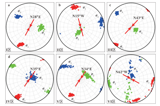
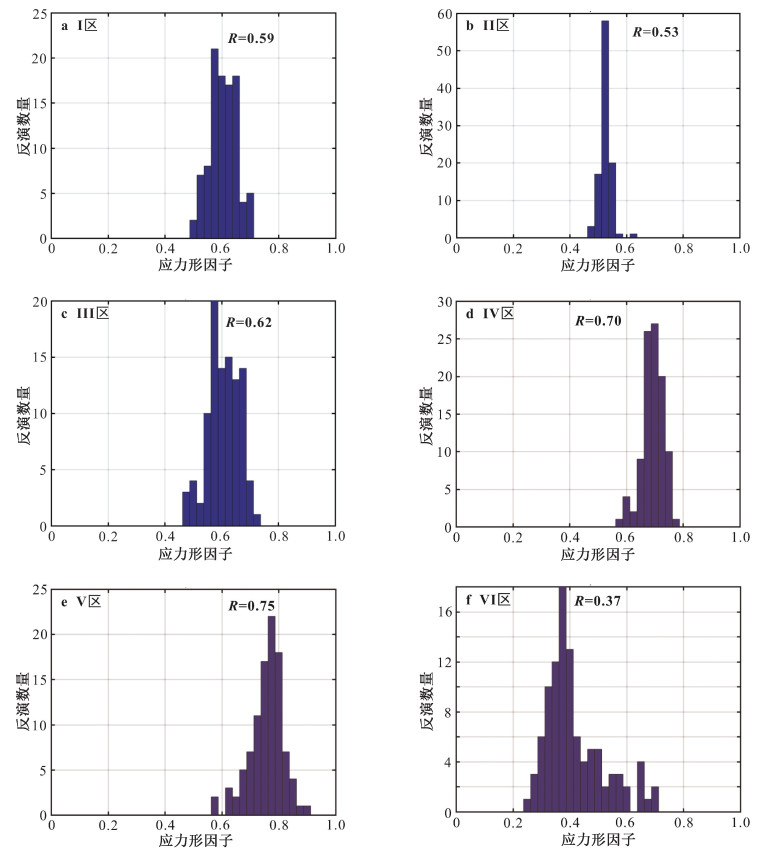
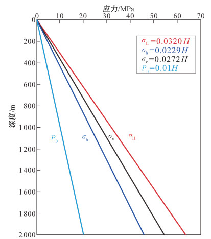
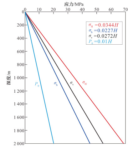
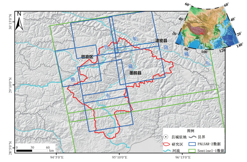
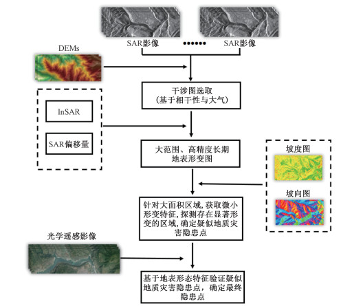
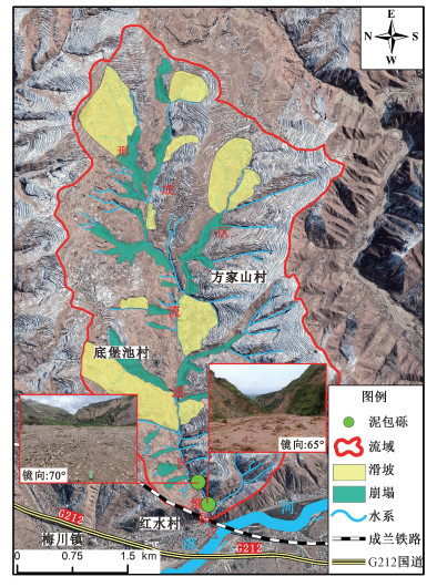
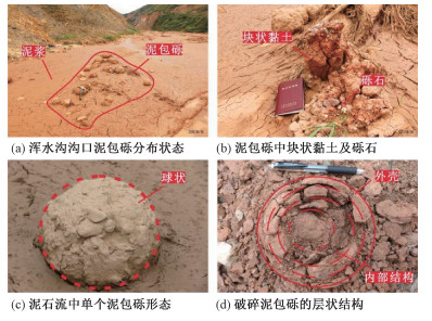
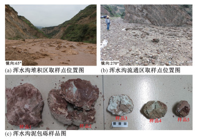
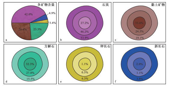
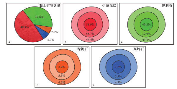
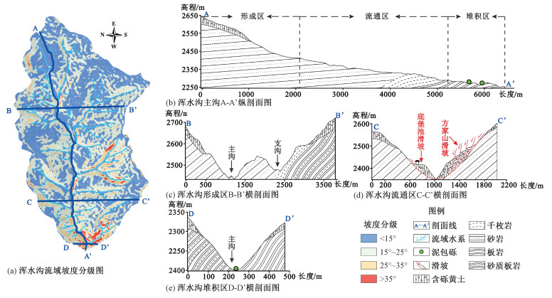
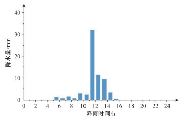
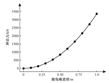
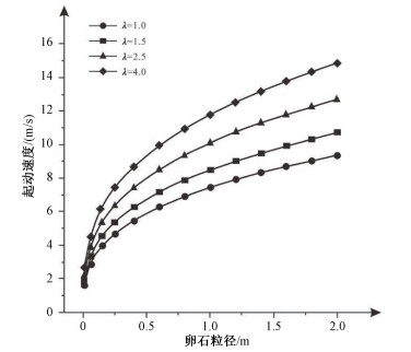
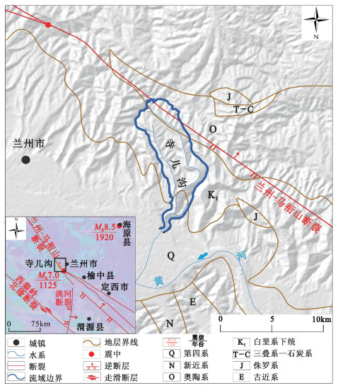
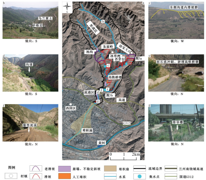
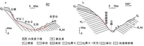
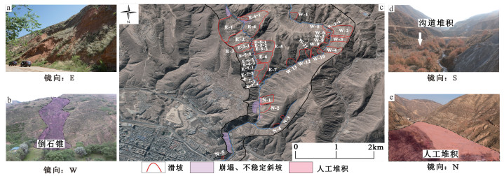
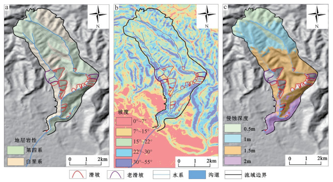
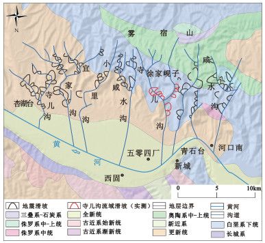
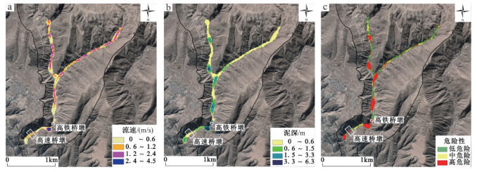
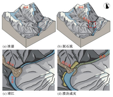
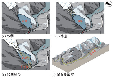
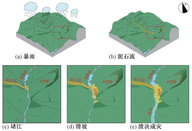
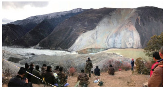
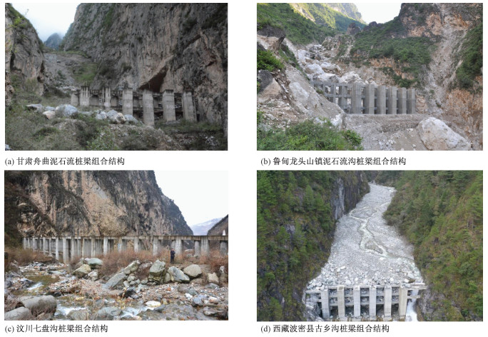
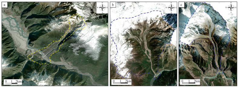
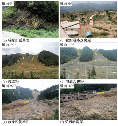
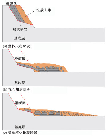
In August 2020, due to the continuous rainfall in southeast Gansu, especially the heavy rainfall processes, debris flows broke out in the Hunshui gully. The left bank of the Fangjiashan landslide was destabilized and sliding, seriously threatening the safety of the Chengdu-Lanzhou Railway at the mouth of the gully. Based on the field investigation results, remote sensing interpretation, and laboratory tests, we studied the mud-coated gravel's morphology, mineral composition, and accumulation characteristics, analyzed the geological environment and mechanism for its formation and discussed its disaster-causing significance. The results show that mud-coated gravels are distributed in the lower reaches of the circulation area and the accumulation area. It presents a spherical and multi-layered structure composed of quartz, calcite, clay minerals, etc. Its formation is mainly controlled by the clay minerals in the Quaternary loess and Paleogene mudstone in the basin. The slow-moving gullies, landslides, and collapses developed on the bank slope as well as appropriate hydrodynamic conditions, promoted the formation and autogenesis of the mud-coated gravel. The impact force of debris flow increases with the particle size of mud-coated gravel, and the critical velocity required for restarting a debris flow is smaller than that of block rock. Mud-coated gravel is the result of the joint action of the Paleogene mudstone and debris flow, and it can aggravate the debris flow hazard. Therefore, it is urgent to control the debris flows in the Hunshui gully to ensure the safe operation of the Chengdu-Lanzhou Railway.

Provenance characteristics and risk analysis of debris flows in Siergou, Lanzhou City
MA Siqi, YANG Weimin, ZHANG Chunshan, QU Jingkai, WAN Feipeng, TANG Haibing
2022, 28(6): 1059-1070. doi: 10.12090/j.issn.1006-6616.20222829
Abstract (496) HTML (142) PDF (24838KB)(53)
Abstract:

Located in the Xigu District of Lanzhou City, Gansu Province, the Siergou watershed has historically experienced large-scale debris flows that have caused significant casualties and property damage. Based on the field survey and remote sensing interpretation, we studied the characteristics of the material source and influencing factors of the debris flows in Siergou through existing literature and indoor tests. We used the FLO-2D software to simulate and analyze the risk of debris flows. The results show that Siergou is dominated by viscous debris flows, which exhibit low-frequency activity and are currently in recession. There are abundant material sources in the Siergou watershed, which can be classified into four types: slope-type, landslide-type, ditch-type, and manmade-type, among which the landslide-type and ditch-type source control the outbreak scale of debris flow. The volume of a one-time flush-out mainly depends on the development degree of a landslide when the landslide occurs. The more developed the landslide is, the larger the one-time flush-out volume is and the larger the scale of the debris flow is. Under critical rainfall conditions, debris flows will break out in Siergou and deposit on the circulation area, forming medium-high risk areas, which seriously threaten the safe operation of the infrastructure in the gully, such as the Lanzhou-Xining high-speed railway and the beltways of the Lanzhou City. When extreme heavy rainfall is encountered, larger-scale debris flows will break out in Siergou. Therefore, further study of the risk of debris flows under extreme weather conditions is necessary to provide a geological basis for debris flow prevention and mitigation in this region.

Research on the pattern of typical geohazard chains in the southwest mountainous region, China
TIE Yongbo, ZHANG Xianzheng, GONG Lingfeng, GAO Yanchao, BAI Yongjian, XU Wei, BA Renji, LI Zongliang, GE Hua
2022, 28(6): 1071-1080. doi: 10.12090/j.issn.1006-6616.20222830
Abstract (951) HTML (163) PDF (9450KB)(156)
Abstract:

The southwest mountainous region in China is the worst-hit area due to the most developed geohazard chains. In order to better understand the pattern of the geohazard chains in this region, we analyzed the main control factors and characteristics of the geohazard chains based on 19 typical geohazard events in history. Three classification patterns, namely landslide-type, collapse-type, debris flow-type, and five typical hazard-inducing processes, were summarized. A typical hazard-inducing chain process in each model was selected for analysis. On this basis, we discussed the mechanism of the geohazard chain, the construction of a database and technical standard system, and the measures for preventing and controlling transboundary basin chain-type geohazards, aiming to provide a reference for the regional geohazard prevention and mitigation plan, and the major engineering projects' construction and people's safety in town.

Effectiveness and mechanical characteristics of a pile-beam composite structure in blocking debris flows
WANG Wenpei, YIN Yueping, HU Xiewen, LI Bin, LIU Mingxue, QI Xiaobo
2022, 28(6): 1081-1089. doi: 10.12090/j.issn.1006-6616.20222834
Abstract (481) HTML (123) PDF (15496KB)(60)
Abstract:

The pile-beam composite structure in high-elevation debris flow areas is selected as the research object. Based on characterizing the pile-beam composite structure, the particle-flow simulation analysis program and the explicit dynamic analysis program were used to study comparatively the blocking effects of single-row piles and two-row piles, as well as that of a pile-beam composite structure at different positions. Besides, We simulated the mechanical characteristics of the pile-beam composite structure and discussed debris flow accumulation and structural stress transfer after the blocking. The calculation results show that the blocking effect of the pile-boulder force chain formed by the contact between large-size particles in the debris flow with the blocking structure and side boundaries on both sides of the gully could effectively block and delay the subsequent debris flow movement. The blocking effect of the pile-beam composite structure is the best. Meanwhile, the transition zone between the two-row piles further suppressed the flow velocity. When choosing the position for a pile-beam composite structure, we should consider suppressing the debris flow velocity as early as possible at the beginning and the potential energy-kinetic energy conversion process. Meanwhile, we also need to emphasize the design of the reservoir capacity, beware of the escape of debris flow due to a low-head barrier, and choose the optimal solution for the layout. The impact stress by debris flow boulders will be transmitted to the rear pile through the connecting beams, and the connecting parts at both ends of the beam almost reach the yield strength, which needs reinforcement to strengthen.

New scientific issues in the study of high-elevation and long-runout landslide dynamics in the Qinghai-Tibet Plateau
GAO Haoyuan, GAO Yang, YIN Yueping, ZHANG Tiantian, WAN Jiawei
2022, 28(6): 1090-1103. doi: 10.12090/j.issn.1006-6616.20222831
Abstract (461) HTML (85) PDF (7527KB)(87)
Abstract:

The dynamic mechanism of high-elevation and long-runout landslides is always a tricky problem in geological disaster research. Due to the complex geological conditions in the Qinghai-Tibet Plateau, high-elevation and long-runout landslides show more complex and robust dynamic action, resulting in disaster chains of ultra-high elevation and ultra-long distance. The article presents a systematic review of the geological characteristics, physical model tests, and numerical analysis of three prominent dynamic effects of high-elevation and long-runout landslides in the Qinghai-Tibet Plateau, namely, dynamic fragmentation, dynamic erosion, and fluidization. Given the current research status of high-elevation and long-runout landslides in the Qinghai-Tibet Plateau, three significant aspects are proposed to be studied in the future: the mechanism of high-elevation and long-runout landslides in extreme geological environments, new methods for model tests based considering size effect, and basin-wide hazard chains induced by high-elevation and long-runout landslides.

Numerical simulation analysis of the solid-liquid coupling process in a hybrid landslide: A case study of the Wushanping landslide
ZHANG Han, GAO Yang, LI Bin, LI Jun, WU Weile
2022, 28(6): 1104-1114. doi: 10.12090/j.issn.1006-6616.20222832
Abstract (428) HTML (187) PDF (19955KB)(68)
Abstract:

The solid-liquid coupling process is crucial in transforming debris flow to mudflow to form a hybrid landslide, which extends the disaster-affected area. It is a hot topic and a tricky problem to be solved in disaster prevention and mitigation research. We used the self-developed post-landslide damage numerical simulation platform (LPF3D) to explore the dynamic process of the Wushanping landslide induced by heavy rainfall in Chongqing under hydrodynamic action and revealed the solid-liquid coupling mechanism. The results show that hydrodynamic effects in the landslide movement are mainly manifested as liquefaction and dragging. The incremental effects of the two hydrodynamic actions are apparent, which often transform debris flow into mudflow, causing long-runout disasters. A two-phase coupled computational model based on the SPH method is proposed. It restores the two-phase movement of the Wushanping landslide under heavy rainfall conditions considering the combined effects of the fluid state equation, the solid viscoplastic constitutive equation, and the inter-phase forces. The numerical calculation results show that the maximum velocity of the Wushanping landslide is 34 m/s, the maximum accumulation thickness is 21.5 m, the accumulation area is 0.12 km2, and the farthest movement distance is 1300 m. The simulation results are consistent with the actual landslide's accumulation pattern. In conclusion, in the high remote landslide risk investigation and prediction process, the pore water pressure and solid-liquid phase interaction under heavy rainfall conditions need to be fully considered, and the numerical simulation based on the LPF3D method provides a basis for the quantitative risk assessment of high-elevation and long-runout landslides.

Long-runout fluidization disaster simulation analysis of clastic landslide under heavy rainfall: A case study of the Niuerwan landslide
WU Weile, HE Kai, GAO Yang, LI Bin, LIU Pengfei
2022, 28(6): 1115-1126. doi: 10.12090/j.issn.1006-6616.20222833
Abstract (506) HTML (122) PDF (32974KB)(69)
Abstract:

The frequent occurrence of remote landslide disasters under heavy rainfall in the mountainous area with sand-mudstone strata in southwest China is a critical issue to be solved in disaster prevention and mitigation. Taking the July 13, 2020 Niuerwan landslide in Wulong, Chongqing as an example, technical means including UAV image, field investigation, geological condition analysis, and PFC3D simulation were used to study the long-runout motion model of flowslide under heavy rainfall. The results show that the unique stratigraphic structure (Quaternary residual slope soil in the upper part and sand-mudstone in the lower part) is the root cause of the landslide instability and long-runout fluidization movement. Heavy rainfall is the key factor in causing the deep destabilization and overall decline of the landslide, and it also leads to the long-distance movement of the upper saturated residual soil. The long-runout fluidization disaster model of bedding landslide shows the characteristics of overall sliding of the lower layer, mixing of coarse and fine particles of the middle layer, and saturation fluidization in the upper layer. The long-runout fluidization process can be divided into three stages: the overall instability, the mixed acceleration, and the fluidization accumulation. Based on the above research, it is concluded that the investigation and prediction process of long-runout fluidization landslide in the mountainous area with sand-mudstone strata should be based on this particular disaster model to provide a quantitative scientific basis for disaster prevention and mitigation.

Cover Page
2022, 28(6): 902-902.
Abstract (182) PDF (1303KB)(25)
Abstract:
Inside Front Cover
2022, 28(6): 903-903.
Abstract (193) PDF (14521KB)(21)
Abstract:
Inside Back Cover
2022, 28(6): 904-904.
Abstract (244) PDF (7130KB)(27)
Abstract:

Contents of  Volume 28


2022, 28(6): 1127-1130.
Abstract (86) PDF (1020KB)(23)
Abstract: