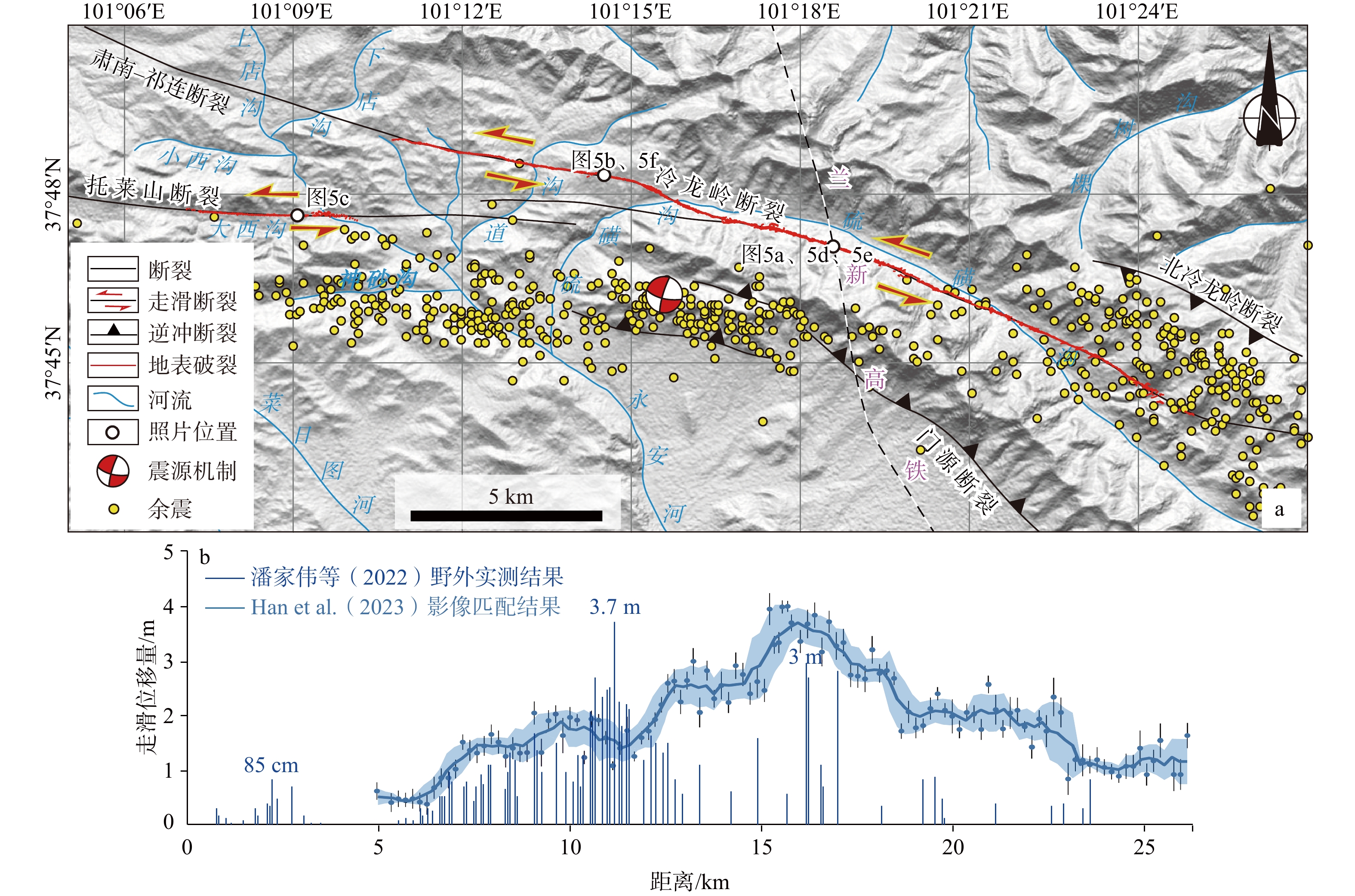
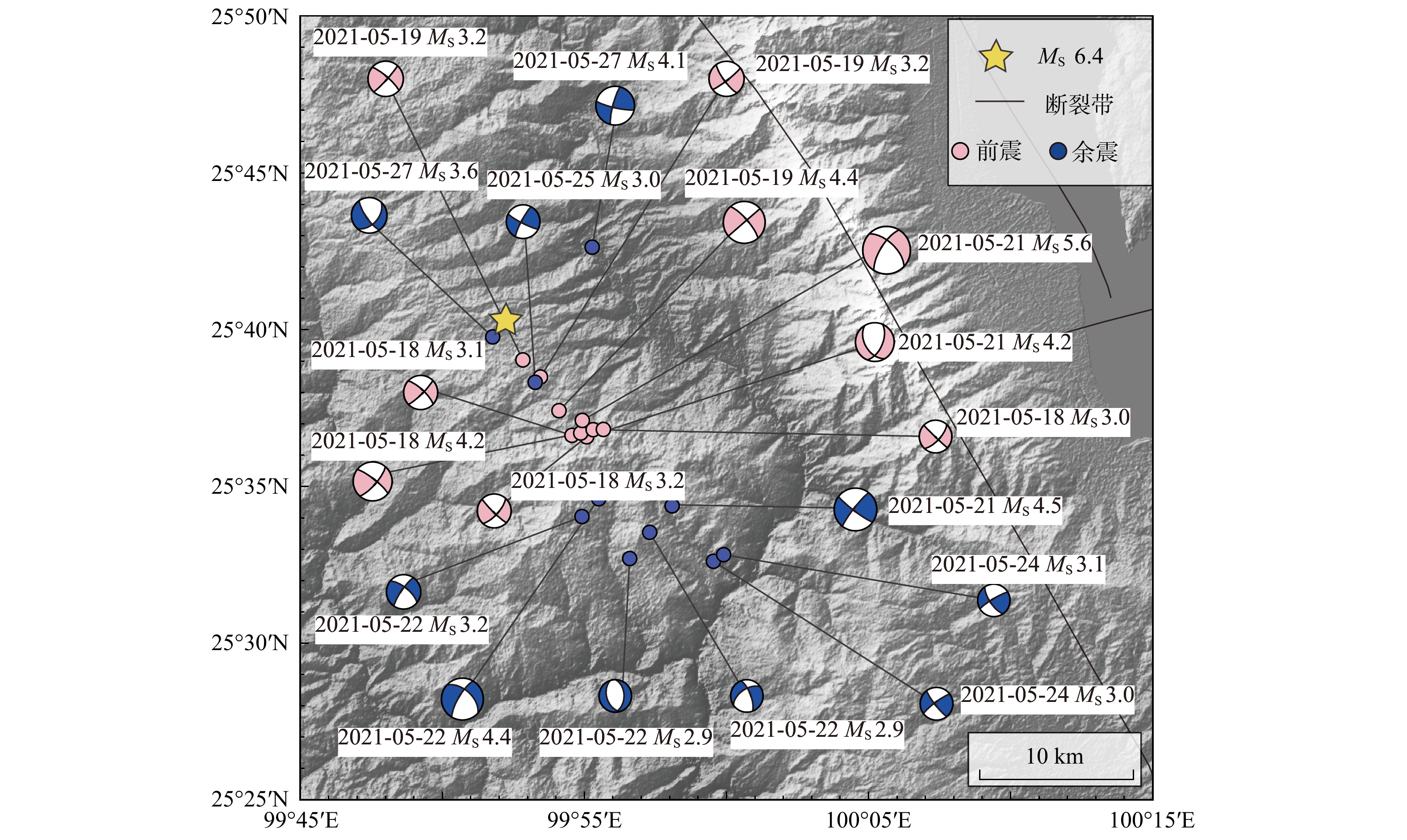
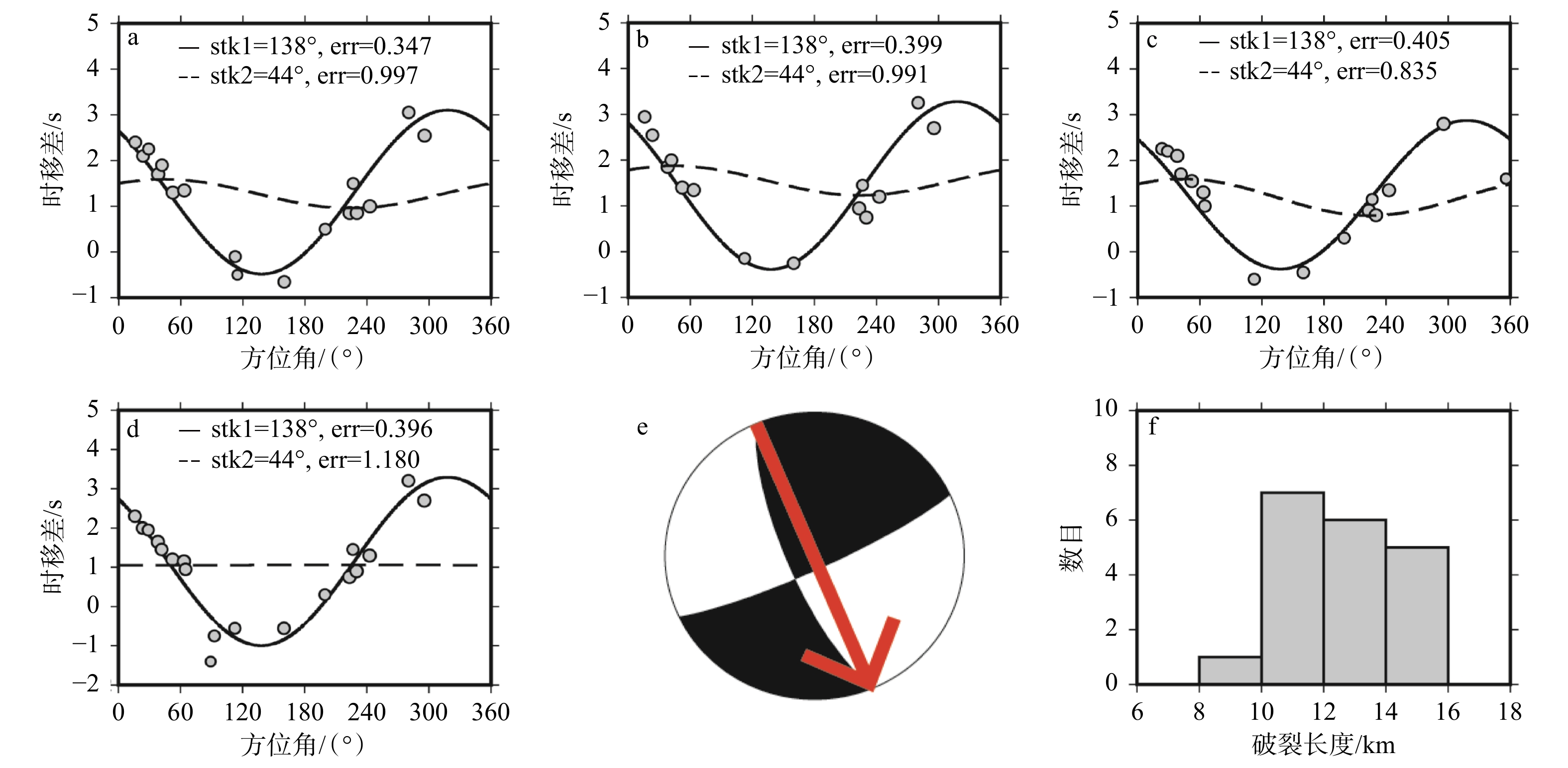
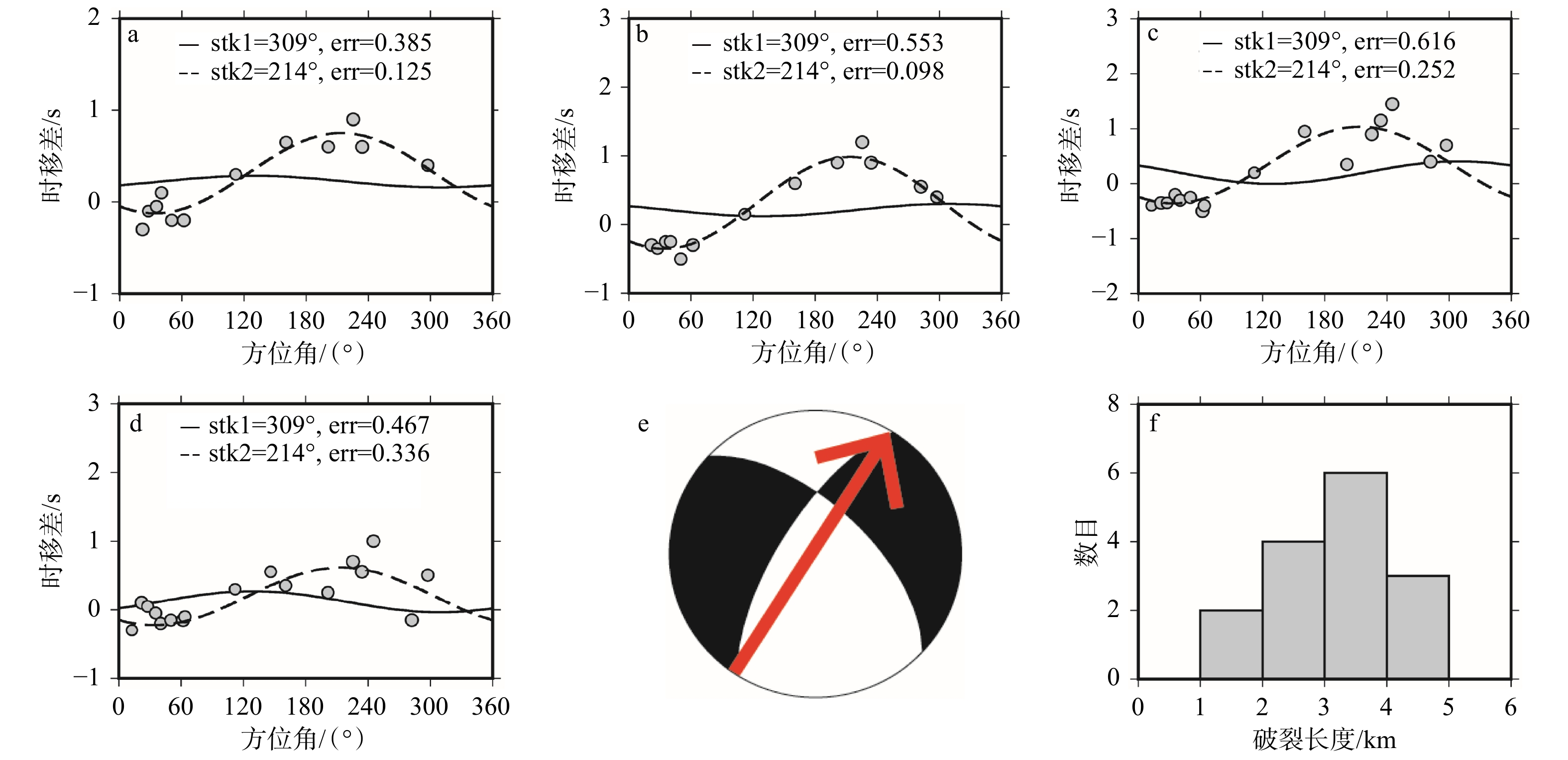
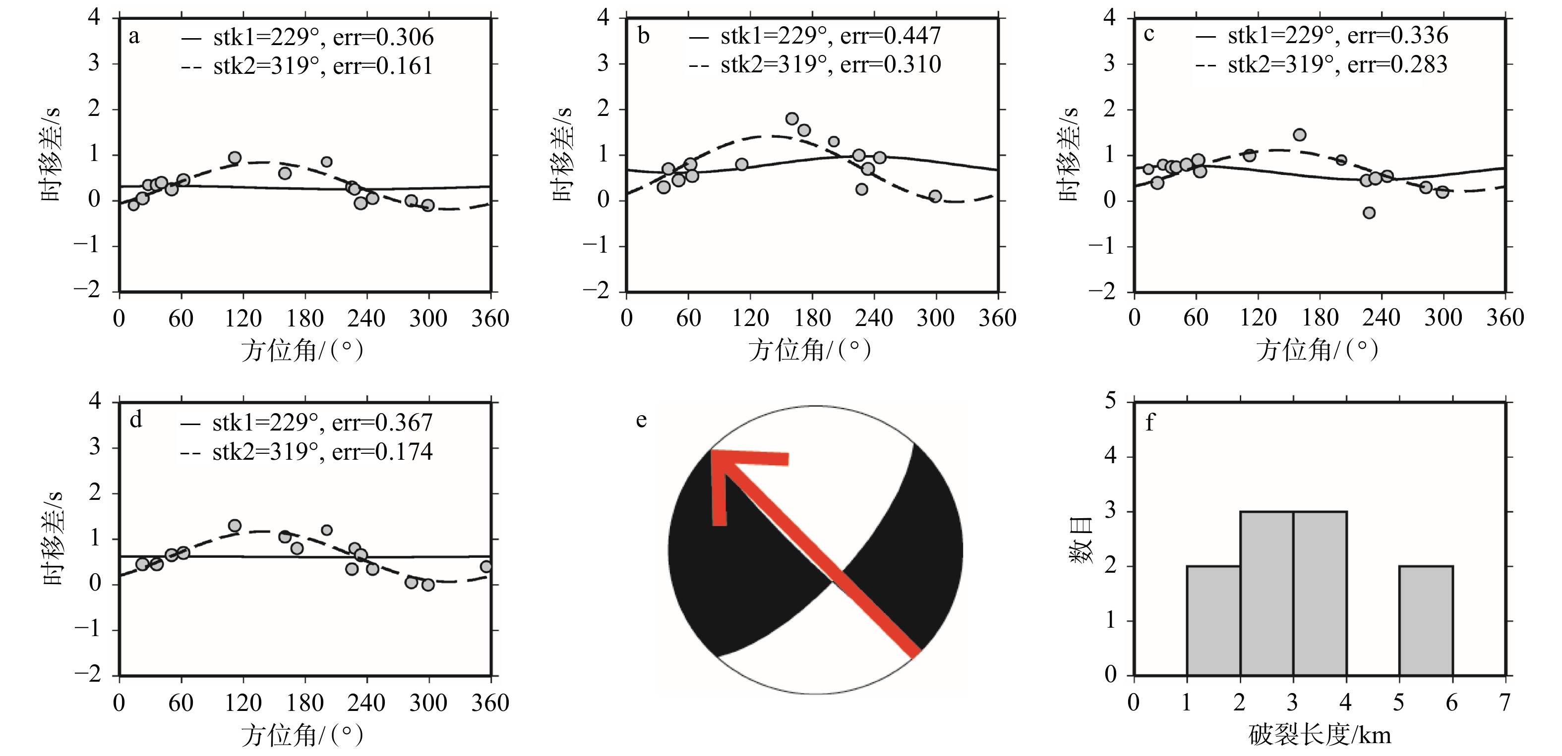
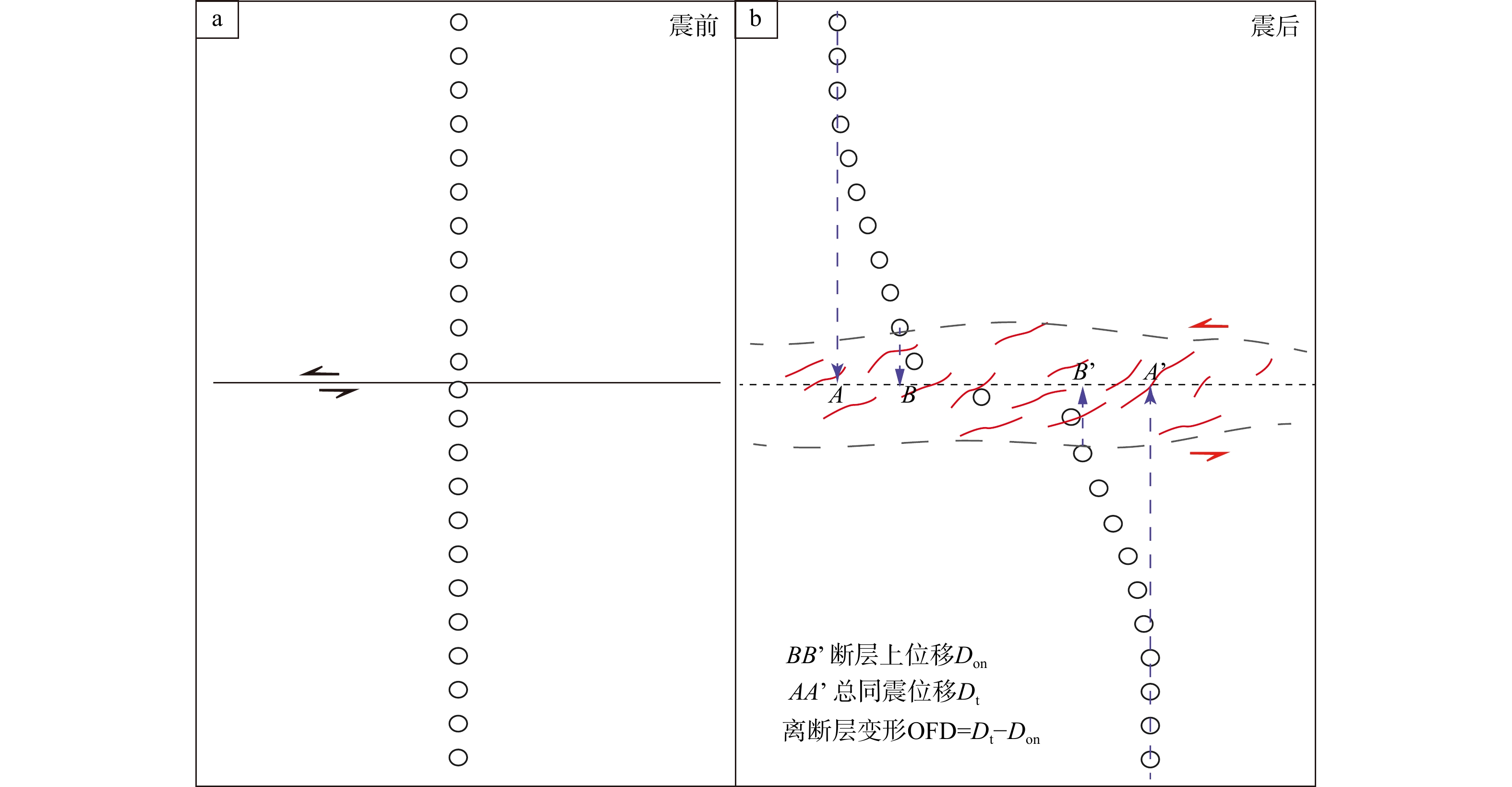
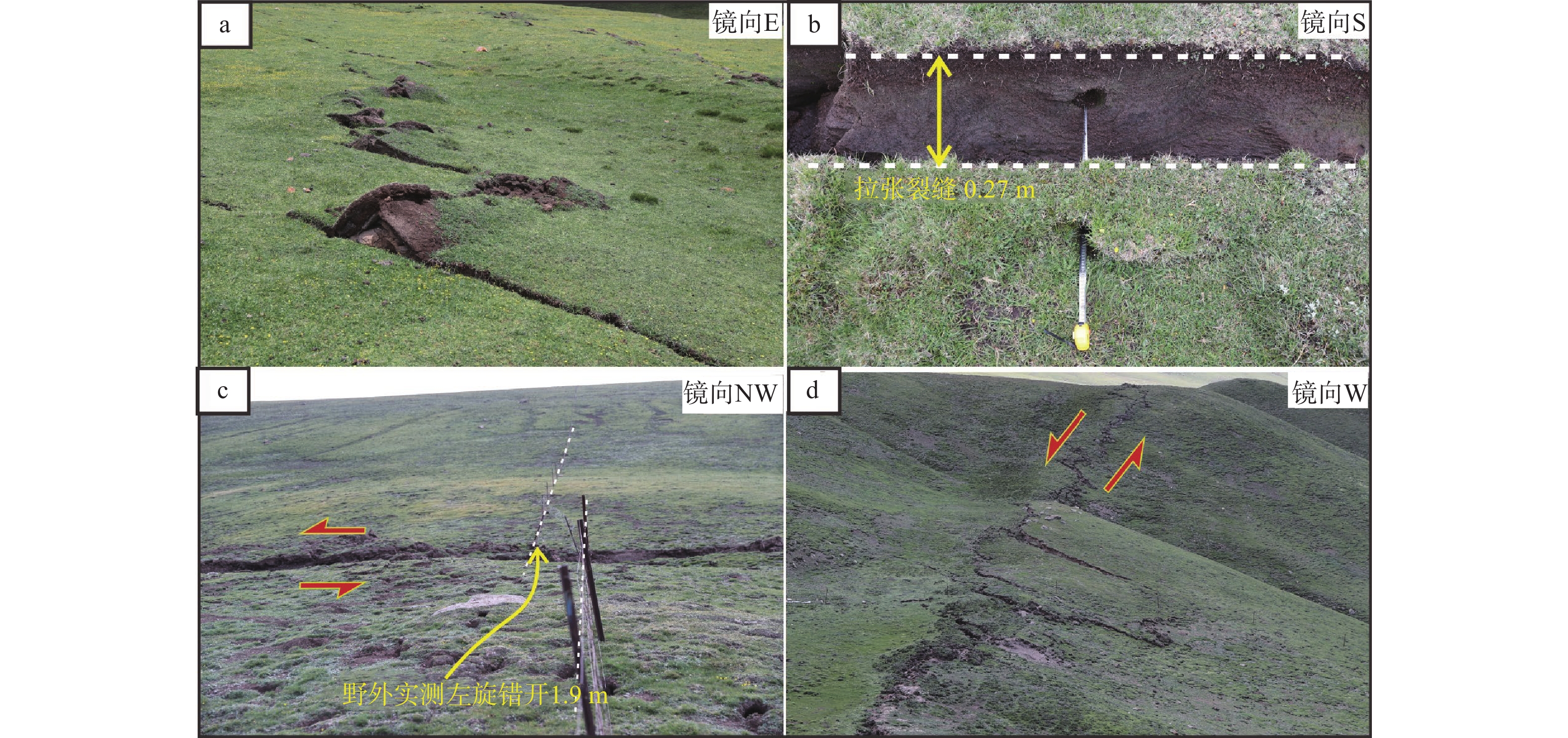
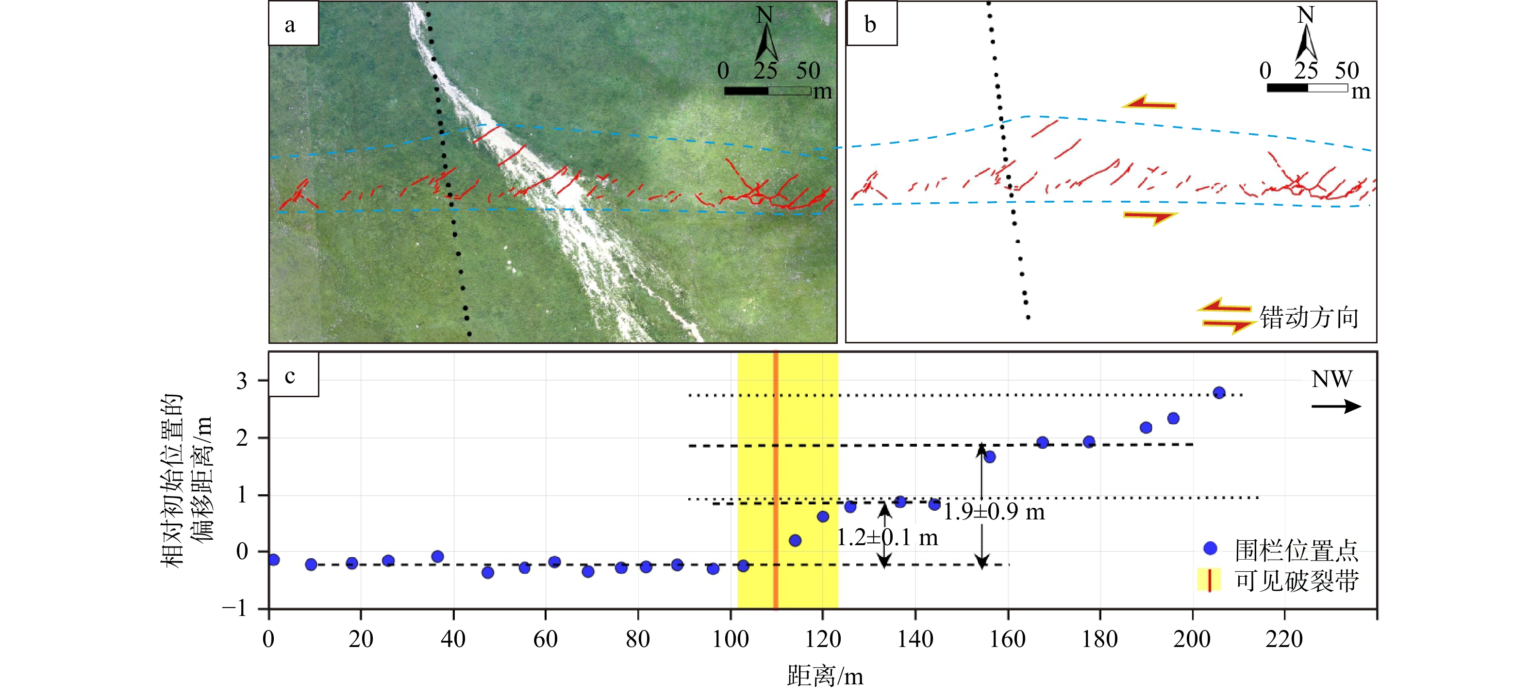
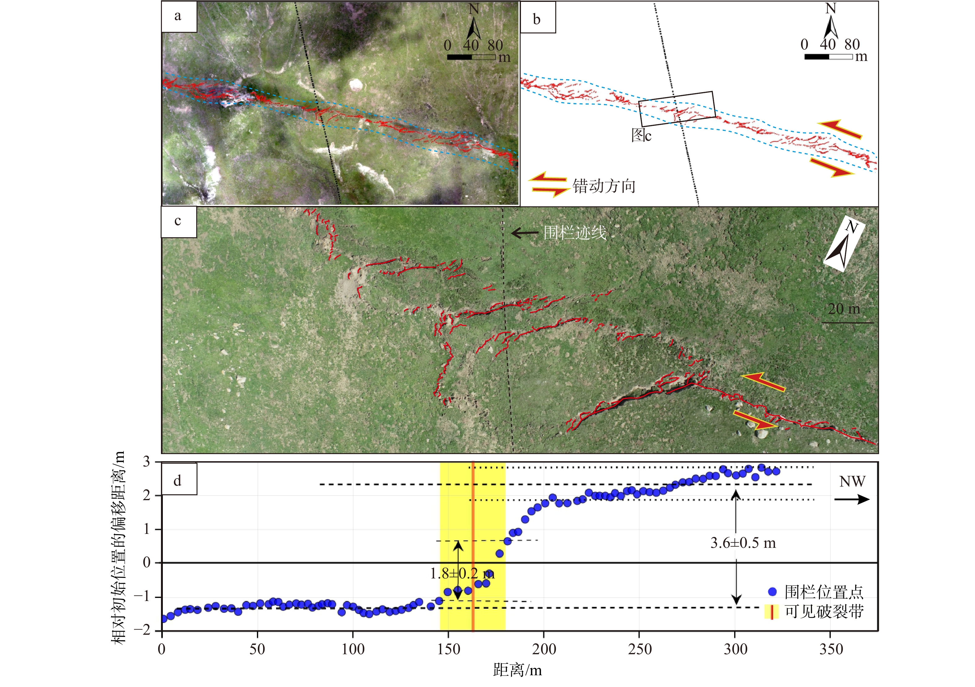
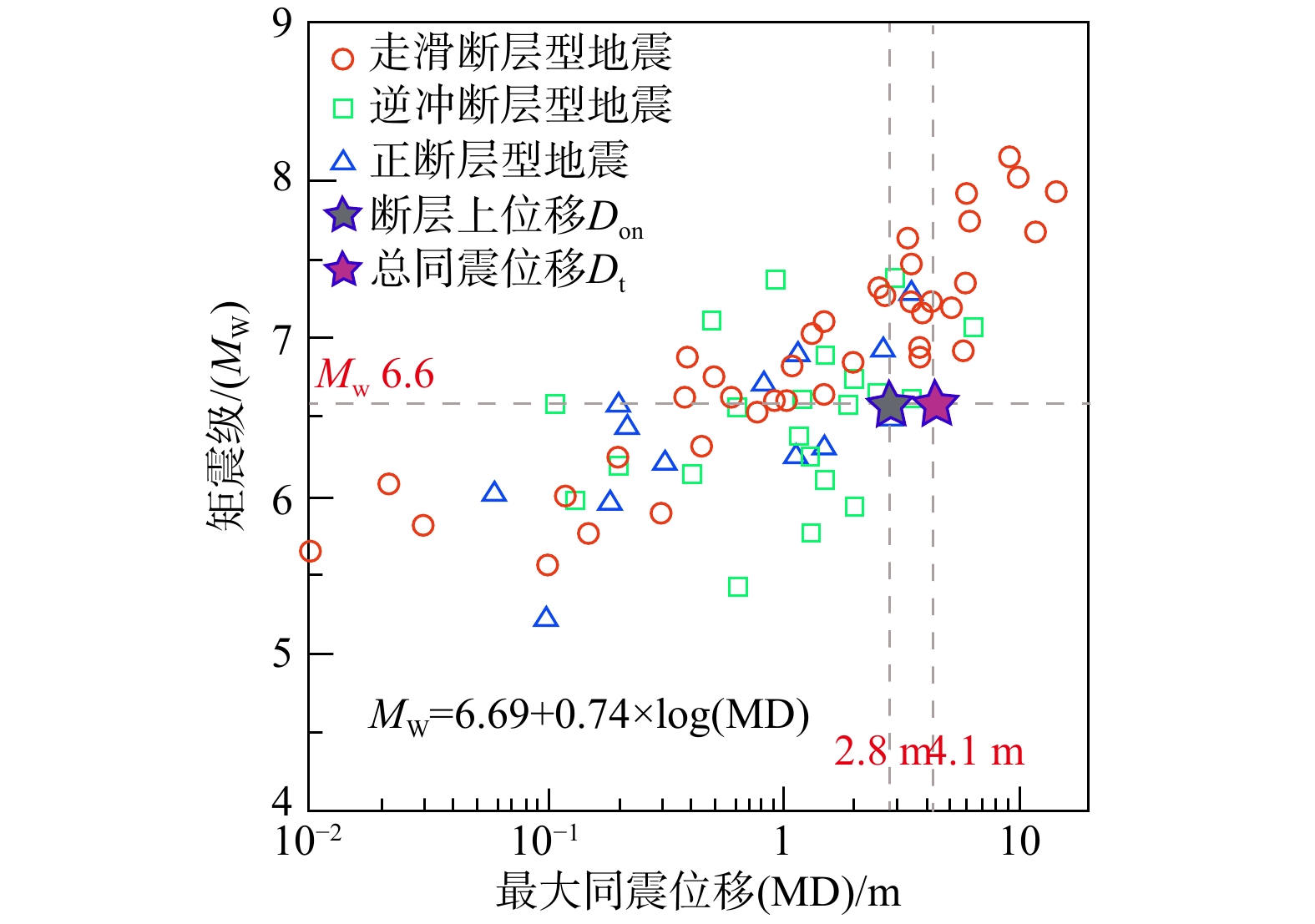
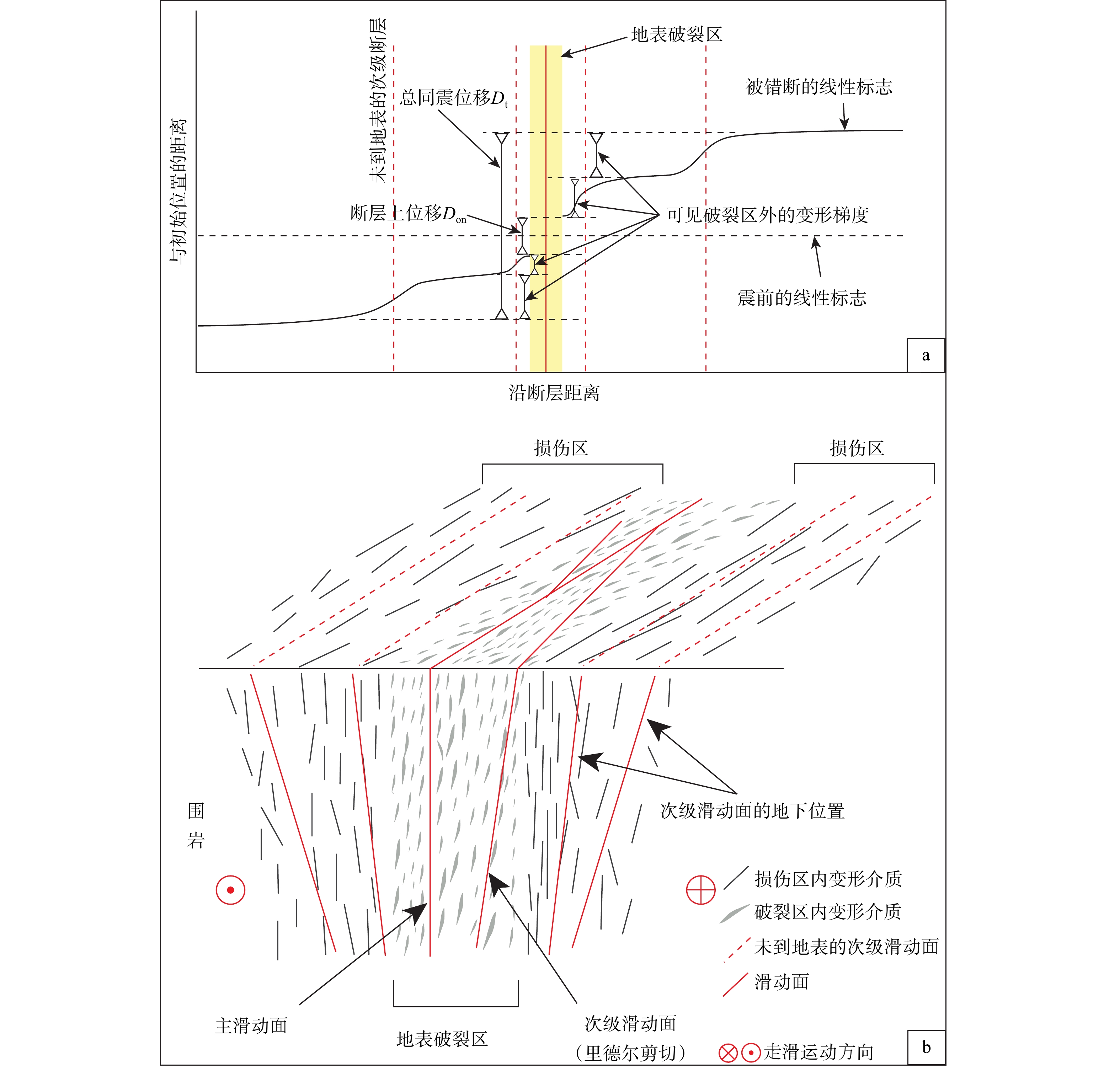
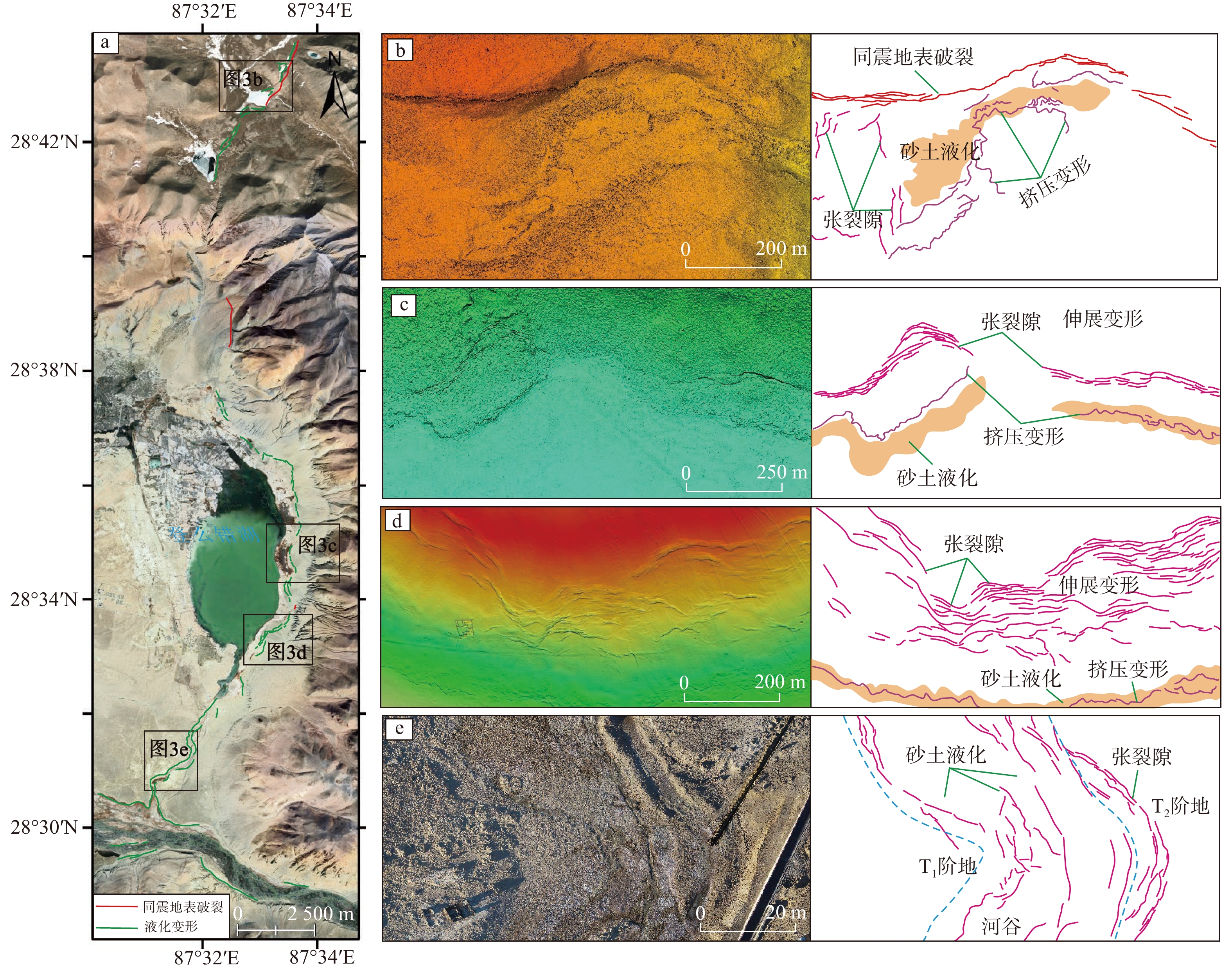
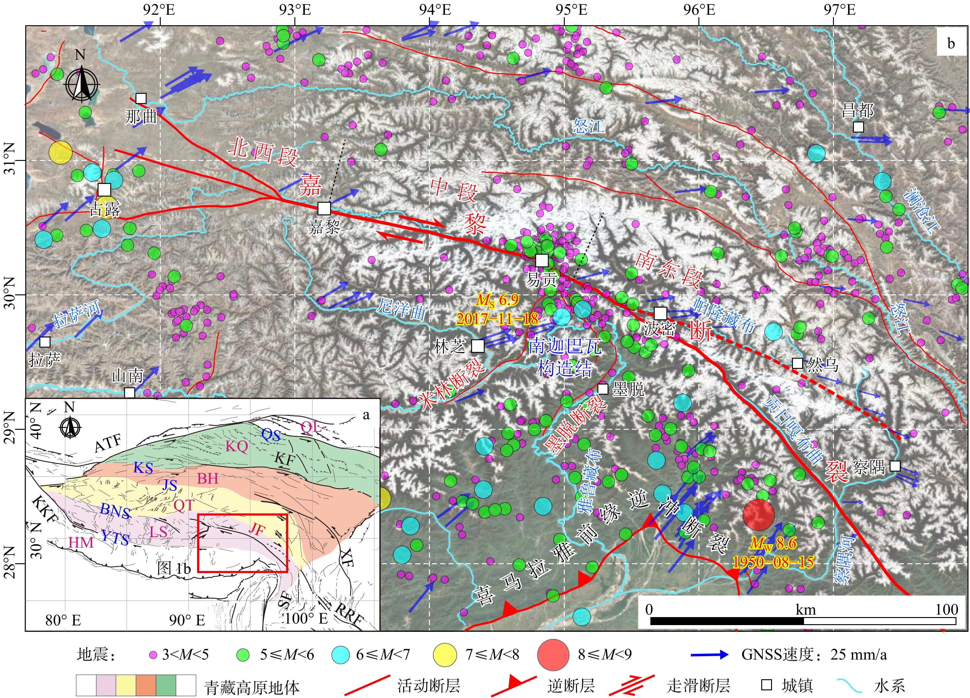
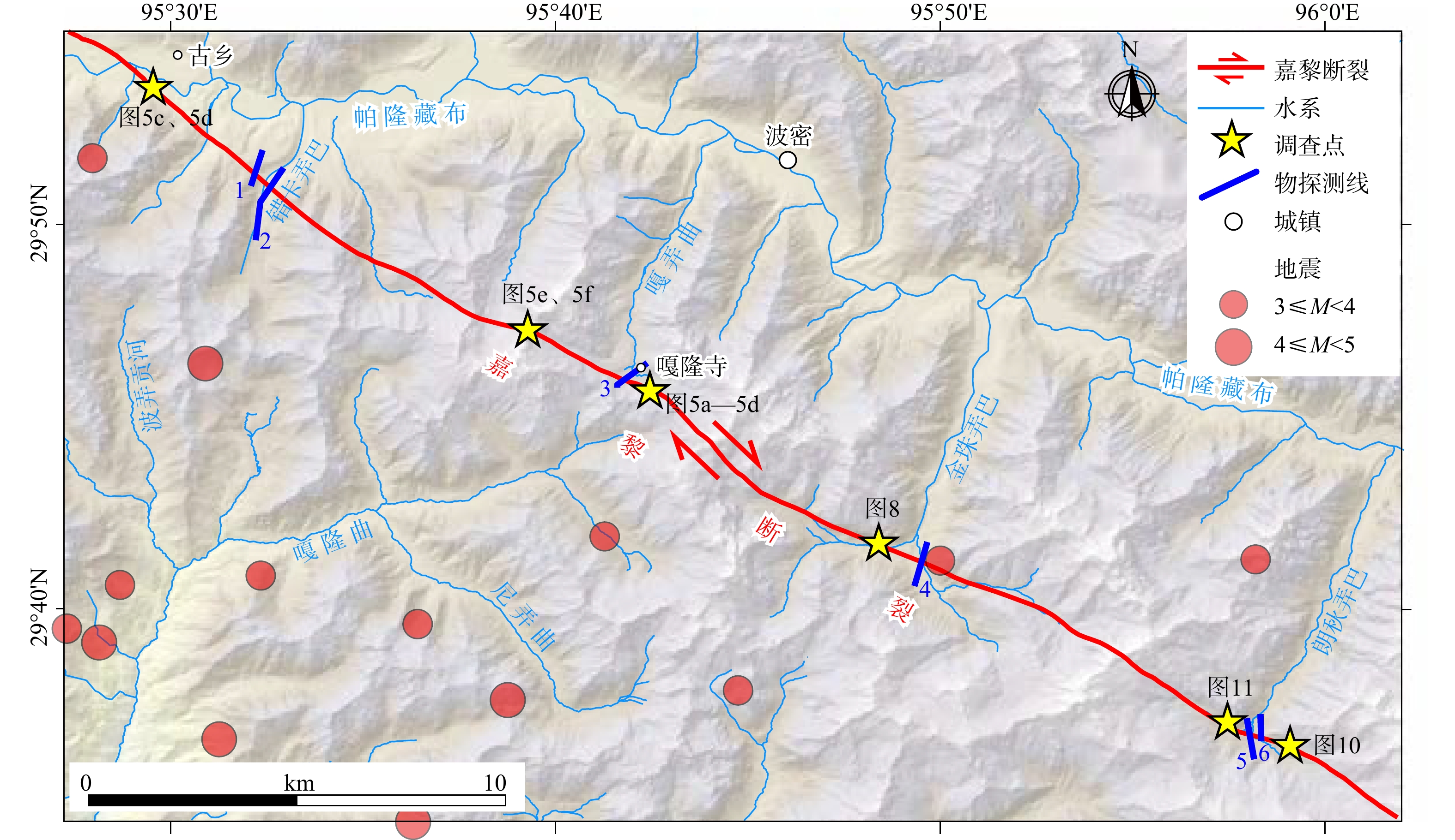
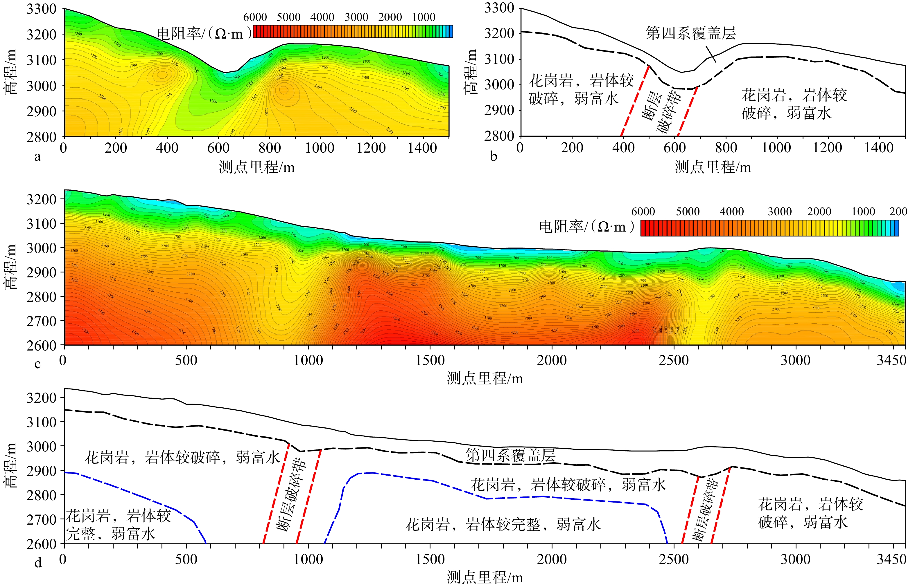
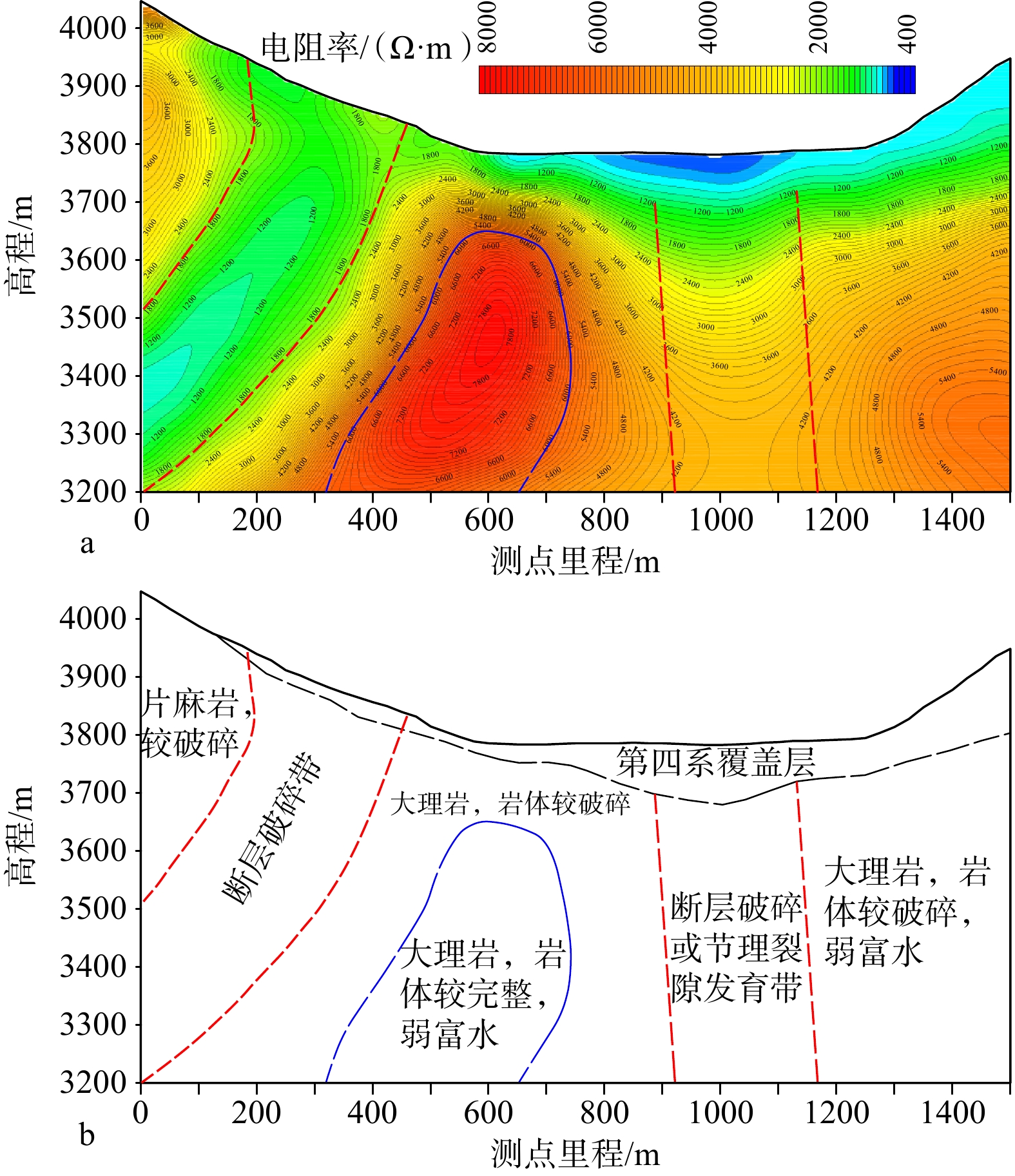
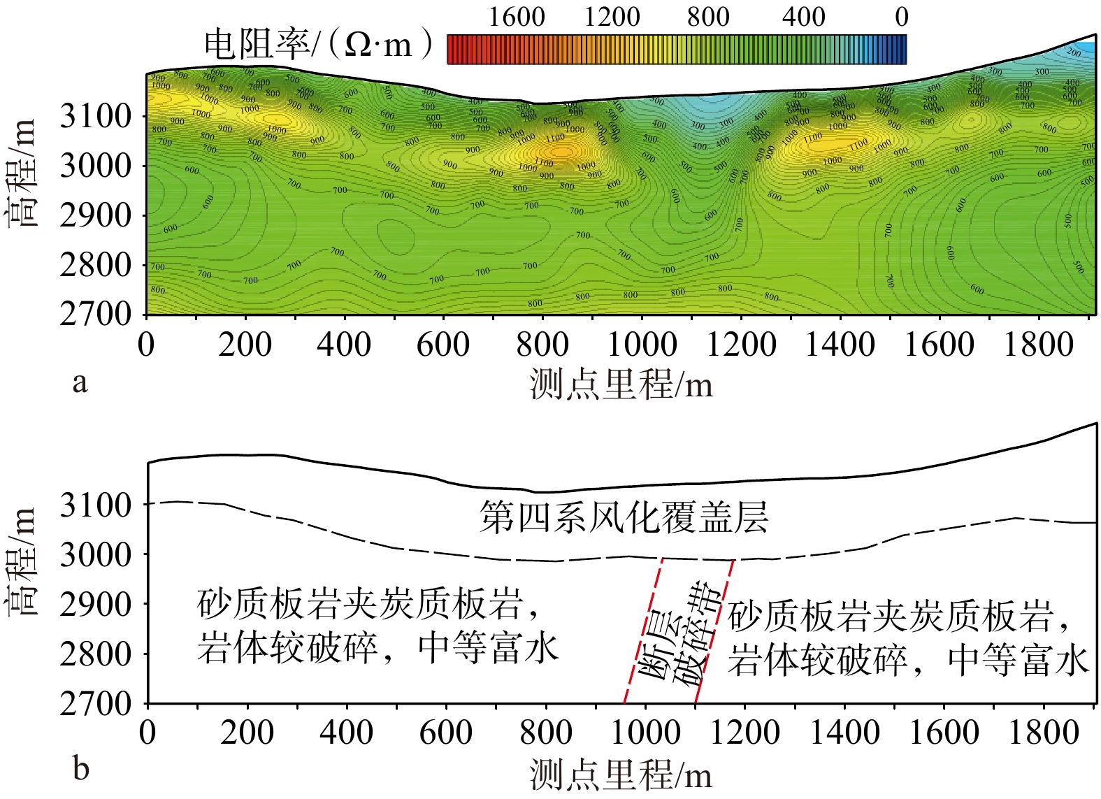
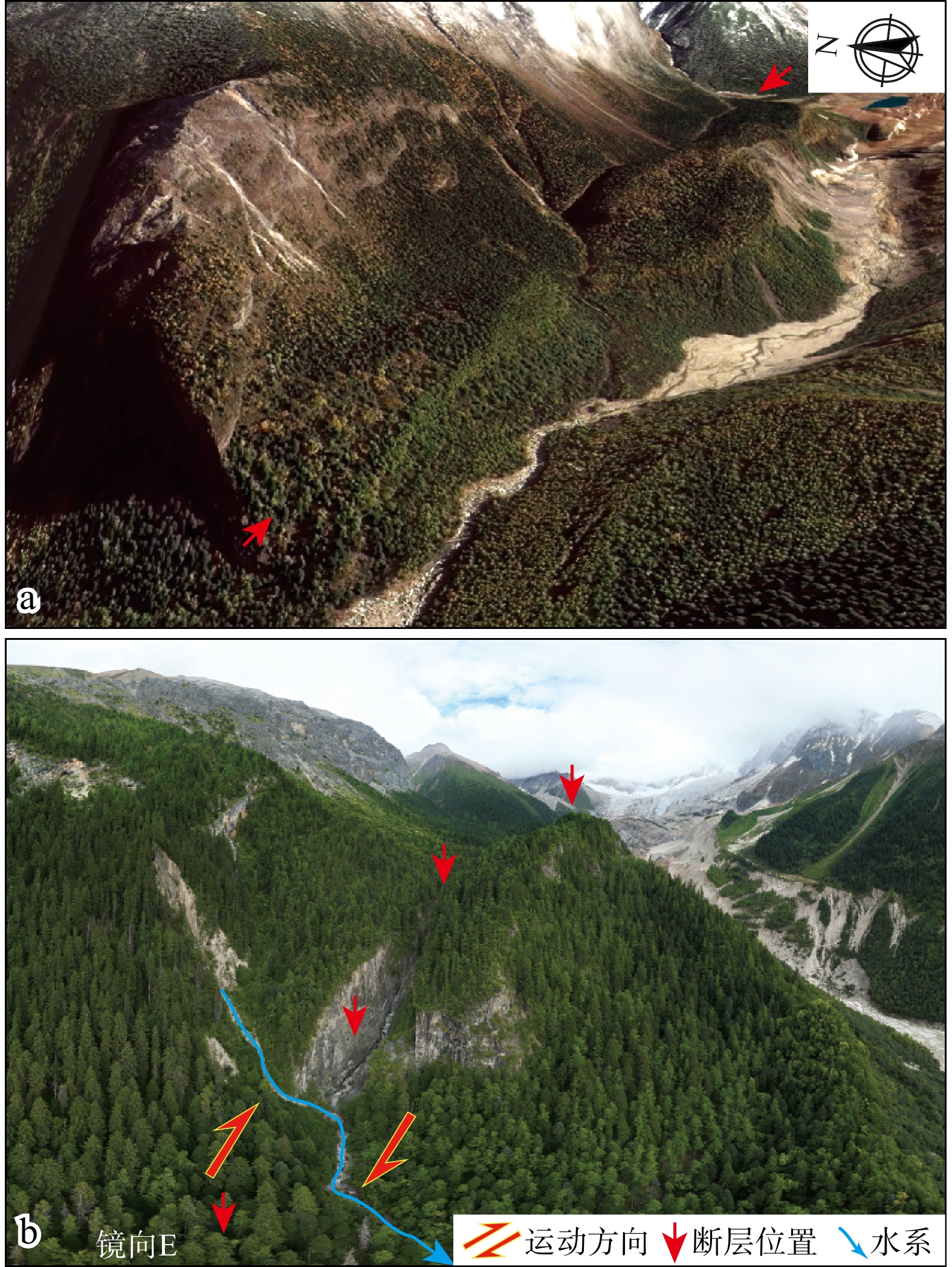
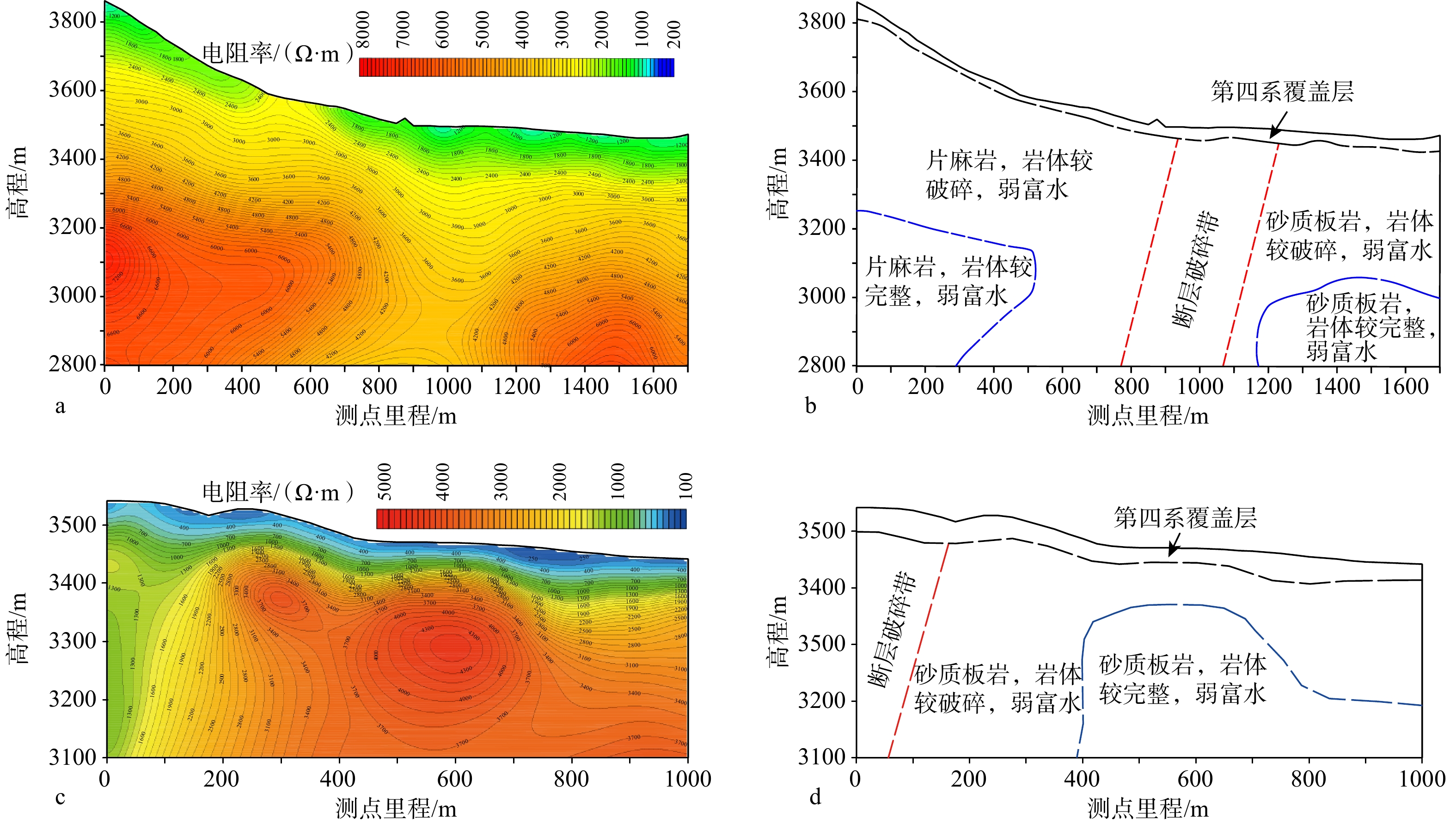
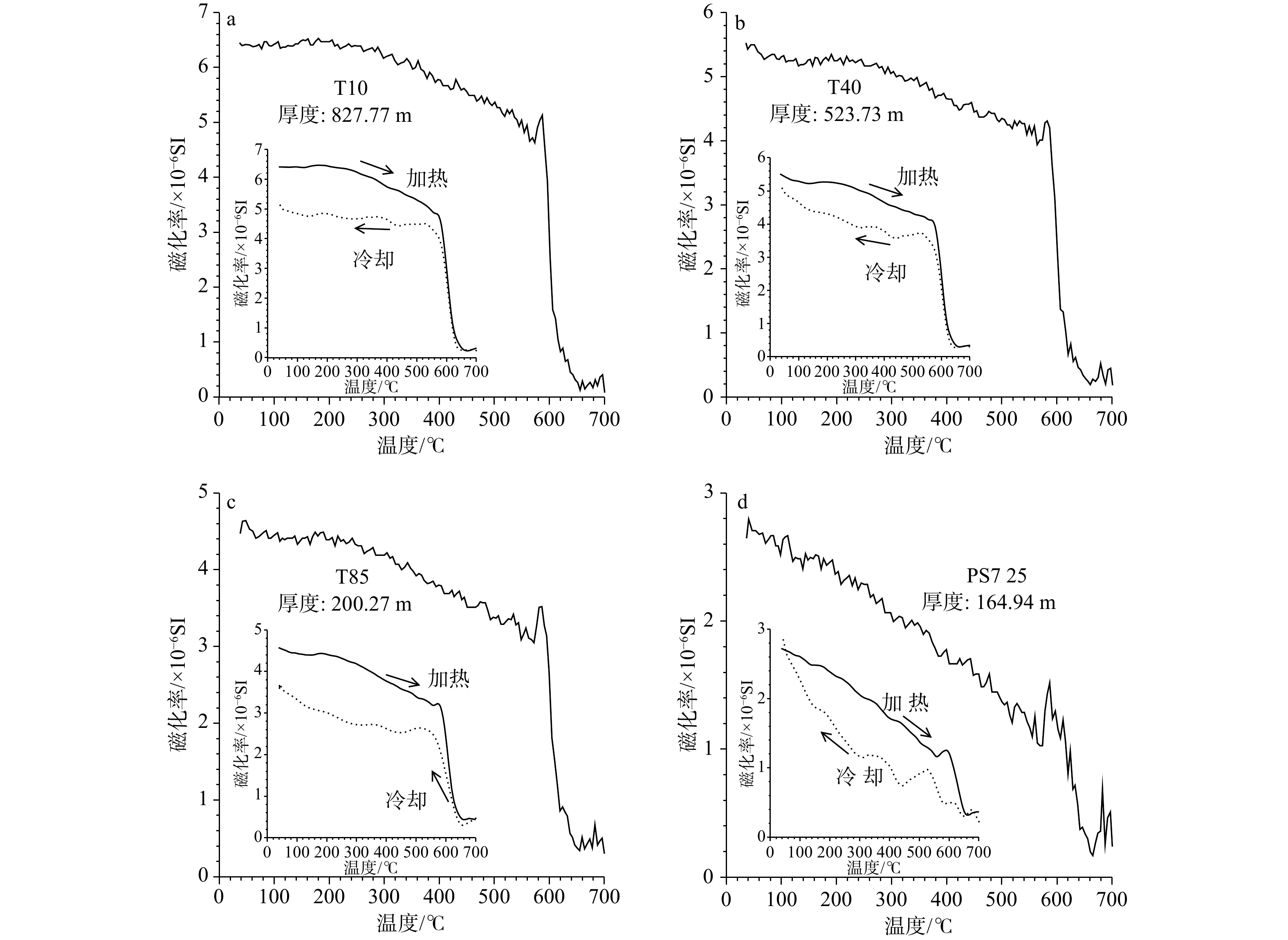
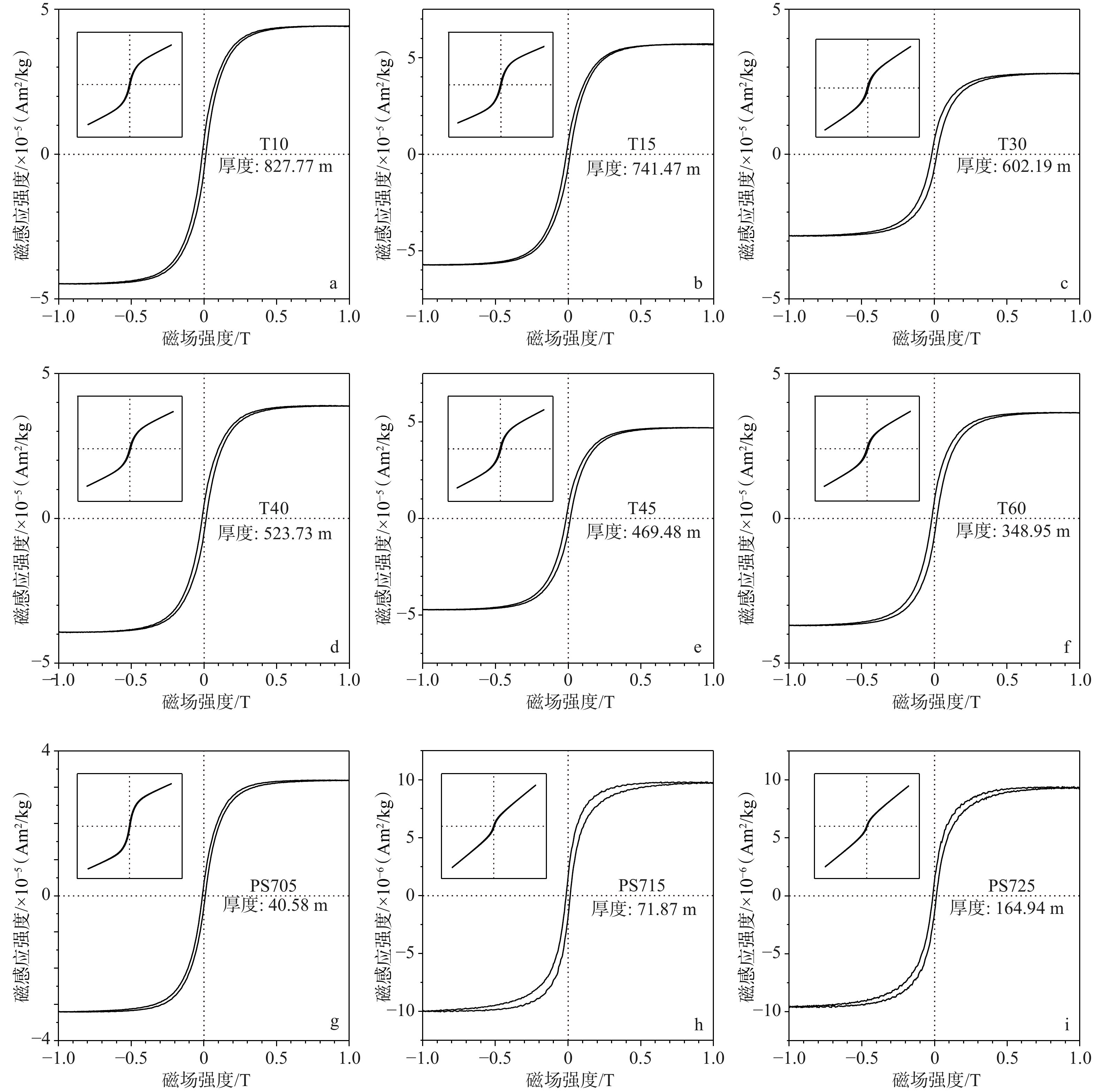
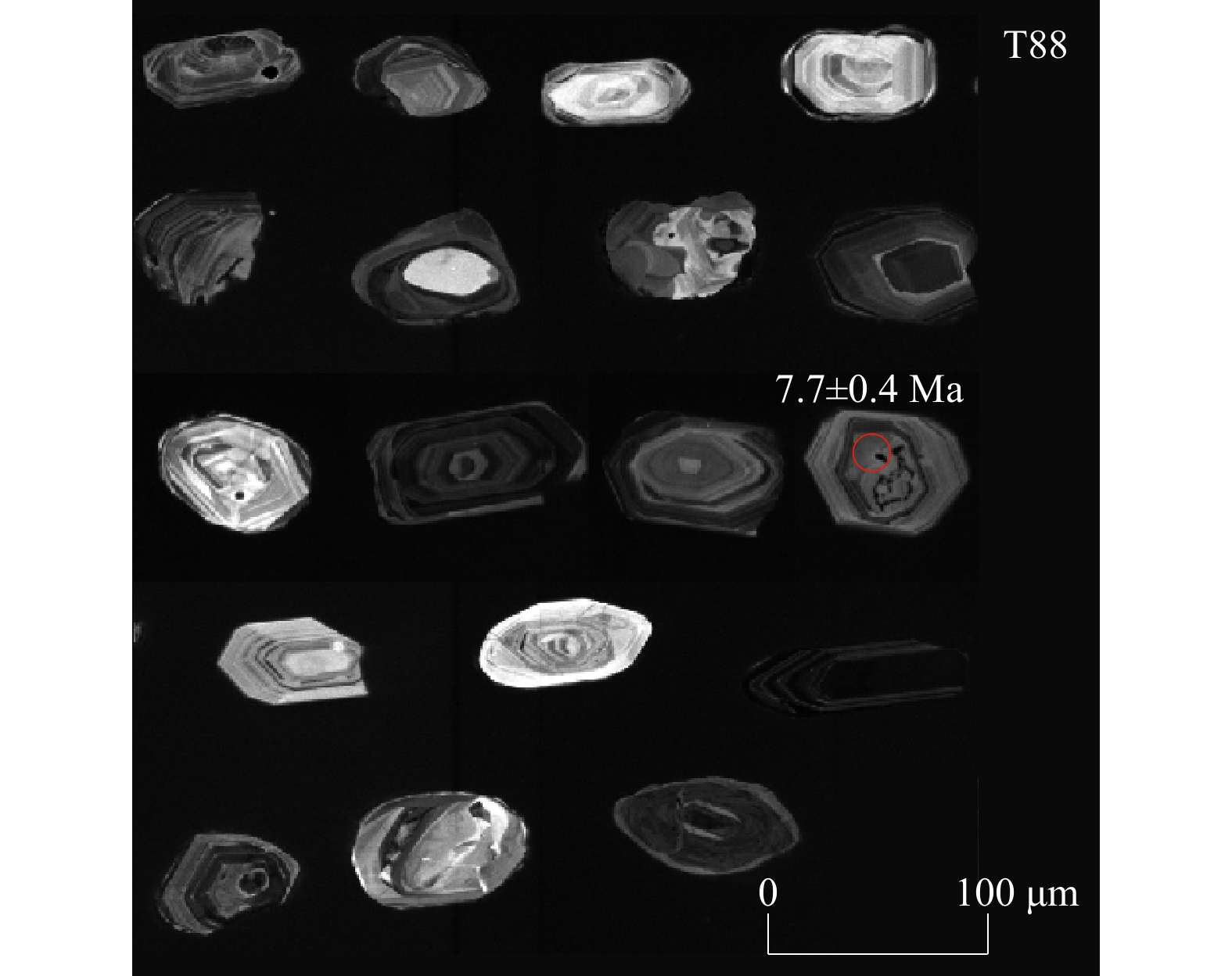
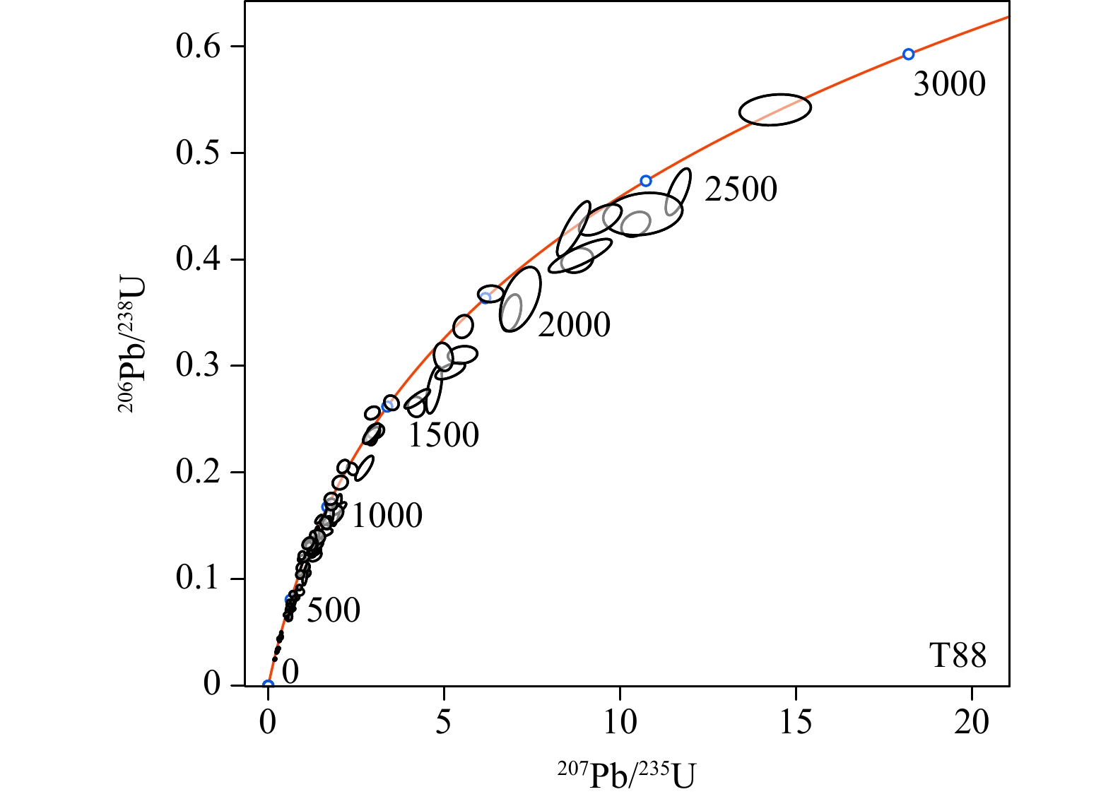
Current Issue

2025, Volume 31,  Issue 2

Cover Page
Cover Page
2025, 31(2)
Abstract (30) PDF (1482KB)(8)
Abstract:
Contents
Contents
2025, 31(2): 1-2.
Abstract (22) HTML (15) PDF (456KB)(5)
Abstract:
Special Section Dedicated to the 30th Anniversary
Analysis of ore-controlling structures of the Shimensi tungsten deposit, Dahutang ore field, northwest Jiangxi Province
CHEN Bailin, GAO Yun
2025, 31(2): 169-196. doi: 10.12090/j.issn.1006-6616.2024106
Abstract (127) HTML (25) PDF (10973KB)(52)
Abstract:
  Objective  The Dahutang tungsten ore field, located in the nearly EW-trending Jiuling uplift belt in northwestern Jiangxi Province, is a recently discovered area of concentrated, world-class, super-large, hydrothermal polymetallic tungsten deposits. It consists of two large tungsten deposits, namely Shimensi, Kunshan, and three medium-sized tungsten deposits, namely the Shiweidong, Dalingshang, Xin’anli deposits. The large Shimensi tungsten deposit is located in the north of the ore field, and the ore bodies are developed in Neoproterozoic granodiorite and Yanshanian granite. The mineralization is of quartz vein type, disseminated veinlet type, and hydrothermal crypto-explosive breccia type, and the three mineralization types occur regularly around the ore-forming granite mass. The ore bodies in the Shimensi tungsten deposit are obviously controlled by structure, but there is little research. Structure is the important ore-controlling factor. The analysis of ore-controlling structures and the construction of tectonic ore-controlling models can help to reconcile the formation and evolution of ore-forming structures and identify the main ore-controlling factors, which can provide technical support for prospection and prediction.   Methods  This study conducts a detailed field investigation of the ore-bearing fracture system, analyzes the combination of different types of ore-bearing fractures, explores the ore-forming conditions, and constructs a structural ore-controlling model.   Results  The research shows that the ore-bearing structure is a multi-directional small fault structure with the main trend being EW, followed by NEE and NWW; all the ore-bearing structures are present in a nearly elliptical distribution with EW-trending long axes. The ore-bearing structures change from the outside to the inside of the ore-forming granite, from those with conjugate dip at medium dip angles to those with sole outward dip at medium dip angles, and those with high dip angles; then hydrothermal crypto-explosion breccia appears in the center of the deposit. Among them, the ore-bearing conjugate shear fractures (with an X-shape in the profile) formed in the magmatic emplacement period little before mineralization in a tectonic stress field with a vertical maximum principal stress and a horizontal intermediate principal stress. The ore-bearing solely outward-dipping fractures with medium or high dip angles were formed as non-conjugate shear fractures and tension-shear fractures in the metallogenic period by hydrothermal crypto-explosion in a tectonic stress field with a vertical maximum principal stress and a horizontal intermediate principal stress. The hydrothermal crypto-explosion center formed in a tectonic stress field with a vertical maximum principal stress and similarly-sized intermediate and minimum principal stresses.   Conclusion  The ore-controlling structures of the Shimensi tungsten deposit are the emplacement structure of the ore-forming magmatic rock with an almost EW(NWW)-trending long axis and the hydraulic fracturing structure of the post-magmatic ore-forming fluid. The emplacement structure of the ore-forming magmatic rock, which was formed a little earlier and distributed over a larger area, developed mainly in the overlying surrounding rock (Neoproterozoic granodiorite) on the top of the ore-forming granite rock mass. The hydraulic fracturing structure of the post-magmatic ore-forming fluid was formed in the metallogenic period within a narrow distribution area in the upper and overlying surrounding rocks of the ore-forming granite rock mass. The latent explosion and hydraulic fracturing of ore-forming fluid instantly reduced the pressure of the ore-forming fluid, leading to the precipitation of ore-forming materials and the crystallization of valuable minerals, forming the tungsten deposits. The emplacement structure of the granite rock mass and the hydraulic fracturing structure of the ore-forming fluid are the sites of the tungsten ore body and control the development of tungsten ore body. The near EW(NWW)-trend of the mining area belongs to a concealed petro-controlling basement structure. This structure causes the long axis of the ore-forming granite rock mass to extend nearly EW and plays an indirect ore-controlling role. The NWW-trending faults such as F20 are neither the ore-conducting structures, nor the ore-controlling structures. They are ore-breaking, post-mineralization structures, with sinistral movement and normal shear sense. The NNE-trending concealed structure in the ore-field controls the distribution of the ore-forming magmatic rock belts and is a high-level petro-controlling structure. [ Significance ] This research can not only guide the exploration of the deeper and peripheral parts of the deposits—that is, further prospection should first search for concealed ore bodies at depth in the plunging part of the eastern and western ends of the near EW(NWW)-trending ore-forming granite rock body, and then search for other granites and fluid metallogenic systems in the area where the concealed ore-forming granite rock mass develops—but also has a demonstrative effect for studies of ore-controlling structures in similar deposits in southern China, enriching the theory of ore-controlling structures for high-temperature hydrothermal deposits.
Characteristics of in-situ stresses and engineering stability analysis on the south section of the Bohai Strait Cross-Sea Corridor project
QIAO Erwei, MA Xiumin, GUO Hualin, Sun Yao, JIANG Jingjie
2025, 31(2): 197-210. doi: 10.12090/j.issn.1006-6616.2023169
Abstract (208) HTML (29) PDF (3996KB)(24)
Abstract:
  Objective  The Bohai Strait Cross-Sea Corridor is an important maritime traffic project which joins the Liaodong and the Shandong peninsulas. The state of geostress is an important reference for engineering design and construction decision-making.   Method  In order to better understand the present characteristics of the geostress and the distribution of the tectonic stress field in the southern section of the project, hydraulic fracturing tests were conducted for stress measurements at 0~300 m depth at Beigou Town, southwest Penglai District, Yantai City.  Results  The analysis of the measured data indicates that the in-situ stress field is controlled by horizontal tectonic stress in the study area, and the horizontal stress values are at an intermediate level compared with those obtained elsewhere in the Northeast−North China Stress Zone; SH (the maximum horizontal principal stress), Sh (the minimum horizontal principal stress), and Sv (the vertical principal stress) change linearly with the depth of the BGZ borehole; in the depth range of the measurements, the shallow surface stress of the crust is mainly reverse fault type, that is, the relationship of the three principal stresses is SH>Sh>Sv. The measured SH average azimuth angle in the borehole, N75.3°E, is in good agreement with the direction of the tectonic stress field of the North China Stress Zone to which the study area belongs; and, it is basically consistent with the direction of the regional tectonic stress field revealed by the focal source mechanism solution and GPS measurement. The Coulomb friction sliding criterion and the measured data are used to preliminarily evaluate the current level of geostress accumulation in the study area and its impact on the engineering stability. It is believed that the overall level of stress accumulation in the region is relatively low, and the crust in the engineering area is currently relatively stable. In addition, based on the comprehensive discrimination criterion of rock burst danger, $\sigma_{{\text{θ}}_{\max}} $/Rc, the possibility of rock burst in the underground tunnel of the Bohai Strait Cross-Sea Corridor is discussed.   Conclusion  It is primarily concluded that there is currently no possibility of rock burst in the underground tunnel of the Bohai Strait Cross-Sea Corridor, and the rock surrounding the tunnel is stable.   Significance  The findings in this paper provide a scientific basis for the optimization of the design and the construction of the Bohai Strait Cross-Sea Corridor. The study also provides basic data for research on active faults, seismogeology, regional dynamics in the survey area, and others.
Earthquake-induced fissures and their formation mechanisms in the 2023 MS 6.2 Jishishan Earthquake
ZHANG Bo, WANG Aiguo, YAO Yunsheng, HE Xiaolong, YAO Saisai, ZHU Junwen, CAI Yimeng
2025, 31(2): 211-222. doi: 10.12090/j.issn.1006-6616.2024114
Abstract (318) HTML (24) PDF (12241KB)(58)
Abstract:
  Objective  Seismic fissures, landslides and mudflows are common secondary hazards of earthquakes. Following the occurrence of moderately strong earthquakes, detailed investigations of landslides and mudflows are usually conducted, but earthquake-induced fissures often receive less attention, because the characteristics and causes of earthquake-induced fissures are controlled by a combination of factors. The 2023 MS6.2 Jishishan Earthquake formed an extensive and dense earthquake-induced fissure zone in the Jishishan Mountain front and the interior of the Linxia Basin, but there are large differences in the understanding of the genetic mechanisms of earthquake-induced fissures.   Methods  In order to better understand the characteristics and genetic mechanisms of earthquake-induced fissures in the Jishishan Mountains, 246 fissures were systematically investigated by field observation, statistical analysis, and drone photogrammetry; then, the distribution, characteristics and genetic mechanisms of the earthquake-induced fissures were analyzed. Combined with relevant published studies, the following new findings are made.   Results  First, the 2023 MS6.2 Jishishan Earthquake formed a large number of fissures in the VII-VIII degree zone, which can be generally divided into two categories: tectonic-related fissures and non-tectonic fissures, and the non-tectonic fissures are further divided into ridge gravity fissures, landslide-related fissures, and valley fissure-sand liquefaction combinations on the basis of the topography associated with these fissures. Second, the tectonic-related fissures developed along the eastern margin fault of the Jishishan Mountains, with fissure widths at the cm-mm level. The tectonic-related fissures extend through fault planes, joints, and other weaknesses of the Jishishan fault zone, clearly showing that the more than 100 m wide fracture zone (i.e., weak zone in the upper crust) of the eastern margin fault of the Jishishan Mountains dominates the distribution of the earthquake-induced fissures. Meanwhile, the tectonic-related fissures tend to develop at weaknesses in man-made structures, such as road seams and bridge joints; this “weakening-preferred” behavior indicates that these fissures are generated by seismic shaking effects on the fracture zone along the fault, rather than direct rupture by the earthquake-causing fault. Thus, the tectonic micro-fissures are not the surface ruptures mentioned above. Third, the non-tectonic fissures mainly developed in the loess-covered area around the Dahejia-Kexinmin-Ganhetan villages north of the epicenter, where the topography is hilly, predominantly tableland and valleys; ridge (tableland) gravity fissures are large in scale, extend far along the ridge, and exhibit a combination of reticulation, parallelism, or en echelon style; landslide-related fissures on the slopes are comparatively smaller in scale and confined to the landslide area; valley fissures are comparable in scale to tectonic micro-fissures and generally formed in association with sand liquefaction; the fissure widths decrease from dm scale on the ridges (tableland) to mm scale in the valleys. Fourth, the tectonic-related micro-fissures healed naturally within approximately half a year, while the healing of the ridge gravity fissures lasted much longer; some landslide-related fissures may take a long time to heal naturally and may even form permanent displacements that pose a serious threat to people and require repair.   Conclusion  By reviewing and analyzing the distribution, types, and genetic mechanisms of earthquake-induced fissures in the 2023 MS6.2 Jishishan Earthquake, and taking into account the magnitude, the epicenter depth, and minor surface displacements, it is speculated that no surface ruptures formed during the Jishishan Earthquake. [ Significance ] An overview of the earthquake-induced fissures of the Jishishan Earthquake is of great significance for understanding the causal mechanisms of secondary earthquake disasters, analyzing seismotectonics, and proposing disaster mitigation strategies.
Crustal Stress & Tectonic Stress Field
Static stress triggering of Morocco M 6.9 earthquake on 9 September 2023
WANG Runyan, WAN Yongkui, GUAN Zhaoxuan, HUANG Shaohua, GU Peiyuan, SONG Zeyao, ZHOU Mingyue
2025, 31(2): 223-234. doi: 10.12090/j.issn.1006-6616.2024039
Abstract (127) HTML (22) PDF (3700KB)(17)
Abstract:
  Objective  Coulomb stress change is an important tool for studying earthquake triggering effects and assessing seismic hazard. In order to study the triggering of the static Coulomb Failure Stress(CFS) of the M 6.9 earthquake in Morocco on September 9, 2023, the study determined the geometric configuration and slip properties of the seismogenic fault, analyzed the co-seismic displacement field and surface strain field generated by the earthquake, and evaluated the triggering effects of the mainshock on aftershocks and surrounding faults, revealing the impact of this earthquake on regional seismic activity.   Methods  Using the "central solution" algorithm, two possible nodal planes of the earthquake were determined, and the local stress field was projected onto these two planes. The nodal plane with higher Coulomb stress was selected as the seismogenic fault plane (strike 253.44°, dip 45.43°, rake 81.05°). Based on statistical formulas, the slip properties of the seismogenic fault plane were determined. Under the homogeneous elastic half-space theoretical model, the co-seismic displacement field and areal strain field of the region were constructed. Subsequently, assuming that the focal mechanisms of the aftershocks on the receiver faults were consistent with the mainshock, the triggering effect of the mainshock on the aftershocks was calculated. Finally, the Coulomb stress changes induced by the mainshock on the surrounding faults were computed to assess the seismic hazard.   Results  The results show that the material at the epicenter moved outward, while the material on the north and south sides moved inward, resulting in uplift at the epicenter and slight subsidence on the north and south sides. The static Coulomb stress generated by the mainshock promoted the occurrence of most shallow aftershocks, with a large number of aftershocks located in areas of high Coulomb stress change. Additionally, the western and southwestern segments of the South Atlas Fault, the southern segment of the North Atlas Fault, and the western segment of the South Sous Fault all exhibited Coulomb stress change values exceeding the 0.01 MPa threshold, indicating a very high seismic hazard that warrants attention.   Conclusion  The study demonstrates that the static CFS generated by the M 6.9 earthquake in Morocco significantly influenced the surrounding seismic activity. The mainshock not only promoted the occurrence of aftershocks but also increased the stress on surrounding faults, particularly in the western and southwestern segments of the South Atlas Fault, the southern segment of the North Atlas Fault, and the western segment of the South Sous Fault. [Significance] The study not only assessed the seismic hazard in the region but also provided a foundational dataset for geodynamic research in the area. It contributes to enhancing earthquake monitoring, prediction, and risk mitigation capabilities, promotes the formulation of relevant policies, and safeguards people's lives and property. Therefore, an in-depth exploration of earthquake triggering is of great significance for strengthening post-earthquake scientific research and improving society's ability to respond to earthquakes.
Energy Resources Geology
Study on the coupling between the hanging- and foot-wall beds and the gas content of deep coal seams in the Linxing area, eastern margin of the Ordos Basin
HUO Shaowei, FENG Xingqiang, WU Jian, ZHANG Shouren, ZHOU Lei, QIAN Zhuliang, CHAO Weiwei
2025, 31(2): 235-247. doi: 10.12090/j.issn.1006-6616.2024124
Abstract (118) HTML (16) PDF (1696KB)(16)
Abstract:
  Objective  The deep coalbed methane in the Linxing area at the eastern margin of the Ordos Basin has great potential for exploration and development and has become a key exploration and development target. Research shows that the hanging- and foot-wall beds of the coal seams play an important role in the enrichment and preservation of coalbed methane. At present, there is lack of systematic research on the influence of the hanging- and foot-wall beds of deep coal seams on the gas content, and the coupling between them is not clear. This study aims to extend the theory of methane enrichment in deep coal beds.   Method  Through the comprehensive application of logging, drilling, and mud logging data and the use of the Analytic Hierarchy Process (AHP), the coupling between the characteristics of the hanging- and foot-wall beds of the No. 8+9 coal seam and its gas-bearing property were studied.   Results  The research results are as follows: (1) In the Linxing area, the Benxi Formation–Taiyuan Formation developed in a barrier-tidal flat-lagoon sedimentary system. The No. 8+9 coal seam mainly developed in the supratidal zone, peat flat, and peat swamp, and the sedimentary environments of the hanging- and foot-wall beds are sedimentary microfacies such as mud flat, lagoon, ash flat, and sand flat. (2) Influenced by the sedimentary environments, the hanging- and foot-wall beds are mainly composed of three lithologies, namely limestone, mudstone, and sandstone. The thicknesses of the hanging- and foot-wall beds of the coal seam vary greatly along the lateral extent. The thickness of the hanging-wall bed ranges from 1.90 to 19.00 m, and the thickness of the foot-wall bed ranges from 1.99 to 21.19 m. There are seven different lithological combinations of the hanging- and foot-wall beds, including top-limestone bottom-mud, top-mud bottom-limestone, top-mud bottom-mud, top-mud bottom-sand, top-sand bottom-limestone, top-sand bottom-mud, and top-sand bottom-sand. (3) Further research on the relationship between the characteristics of the hanging- and foot-wall and the gas content of the coal seam shows that the coal seams in top-limestone bottom-mud, top-mud bottom-limestone, and top-mud bottom-mud associations exhibit the highest gas contents; the coal seams in top-mud bottom-sand and top-sand bottom-limestone associations exhibit relatively high gas contents; the coal seams in top-sand bottom-mud and top-sand bottom-sand associations exhibit low gas contents. Within the same lithology, the greater the thickness of the hanging- and foot-wall beds, the higher the gas content of the coal seam, and there is a positive correlation between the thicknesses of the hanging- and foot-wall beds and the gas content.   Conclusion  According to the research results, three types of coupling models between the hanging- and foot-wall of deep coal seams and their gas-bearing properties are distinguished: Type I (good coupling) with a gas content of more than 15 m³/t, Type II (relatively good coupling) with a gas content of 12 to 15 m³/t, and Type III (poor coupling) with a gas content of less than 12 m³/t. [Significance] The research results have clarified the controlling effect of the hanging- and foot-wall beds of deep coal seams on the gas content, which has important significance for guiding the evaluation, optimization, and mining of areas favorable for deep coalbed methane, and further extends the theory of deep coalbed methane enrichment.
Factors controlling enrichment and accumulation of Devonian–Carboniferous shale gas in the Yaziluo rift trough in the Yunnan–Guizhou–Guangxi region
WANG Yufang, ZHAI Gangyi, SHI Wanzhong, WANG Jinzhu, ZHANG Jiazheng, KANG Haixia, ZHANG Yunxiao, ZHOU Hui, ZHANG Shuting
2025, 31(2): 248-266. doi: 10.12090/j.issn.1006-6616.2024059
Abstract (71) HTML (16) PDF (9679KB)(9)
Abstract:
  Objective  Compared with the Wufeng-Longmaxi Formation in the Sichuan Basin and its periphery, the Yunnan-Guizhou-Guangxi region has more complex conditions for the enrichment and accumulation of shale gas. Currently, the exploration degree of shale gas in the Yunnan-Guizhou-Guangxi region is relatively low, and the main factors controlling the enrichment and accumulation of shale gas are unclear.   Methods  This paper relies on a large number of studies from the basic surveys of shale gas and major special projects in the Yunnan-Guizhou-Guangxi region. The research includes the sedimentary characteristics, diagenesis, hydrocarbon generation, thermal evolution characteristics, shale reservoir characteristics, accumulation patterns, and preservation conditions of the Devonian-Carboniferous shale in the Yunnan-Guizhou-Guangxi region.   Results  The research indicated that the deposition of Devonian-Carboniferous organic-rich shale was mainly controlled by rift troughs, and the sweet spots of organic-rich shale were mainly formed in the transgressive system tract and the early highstand system tract of deep-water facies sedimentation. The regional sea level rise has brought abundant nutrients, promoting the wealth of organisms in the water body and generating strong biological productivity, which provides a good material basis for the formation of organic-rich sediments. Seismic interpretation reveals that most of the areas distributed along the main rift trough are greatly affected by destruction by late-stage tectonic activities, leading to the deterioration of the preservation conditions of shale gas. In contrast, the secondary rift troughs around the main rift trough have relatively stable structures, providing good conditions for the preservation of shale gas.   Conclusion  On this basis, the main controlling model for the enrichment and accumulation of shale gas in the Devonian-Carboniferous system in the Yunnan-Guizhou-Guangxi region is proposed: "rift trough deposition, deep-water lithofacies controlled hydrocarbon generation, and structural preservation in secondary rift troughs". The model has been confirmed through the drilling of multiple wells. [ Significance ] The results of this research can be used as a guide for the optimal selection of favorable shale gas areas and for the drilling of parameter wells in the future.
Geo-hazards & Engineering Geology
Formation mechanism and stability analysis of a landslide in altered ophiolite in the upper reaches of Jinsha River: A case study of the Duirongtong landslide
RAN Lina, ZHANG Yongshuang, REN Sanshao, LI Jinqiu
2025, 31(2): 267-277. doi: 10.12090/j.issn.1006-6616.2024084
Abstract (136) HTML (42) PDF (3539KB)(22)
Abstract:
  Objective  The tectonic suture zone of the Qinghai-Tibet Plateau has a complex rock mass structure and special lithology combination and is thus prone for large landslides. However, many factors influence the formation and evolution of landslides in altered ophiolite. Their formation mechanism is not clear at present, which restricts an effective identification and disaster risk prevention.   Methods  Taking the Duirongtong (DRT) landslide in the Jinsha River tectonic suture zone as an example, field investigations, UAV mapping, geochronological analysis, ring-shear testing, and numerical simulation were performed to analyze the formation mechanisms of the landslide and evaluate the stability of the landslide deposits.   Results  The results show that: (1) The DRT landslide is a giant landslide formed in the late Pleistocene. The slope is mainly composed of basic-ultrabasic rocks, and several clay-altered ophiolitic bands are developed, forming a sliding-prone geo-structure. (2) The clay-altered ophiolite has low shear strength under natural conditions, and its shear strength drops sharply when exposed to water. The natural values of c and φ are 67.0 kPa and 20.3°, and the water-saturated values of cohesion(c) and angle of internal friction(φ) are 39.8 kPa and 13.83°. The DRT landslide is currently stable as a whole, but the leading edge of the landslide may experience movement under heavy rainfall. Based on numerical simulation, some preventive recommendations are proposed.   Conclusion  The study suggests that the formation and evolution of the DRT landslide are controlled by the combination of geological structure and clay-altered rock. [ Significance ] These findings have important implications for the slope stability analysis and disaster prevention in the tectonic suture zone of the Qinghai-Tibet Plateau.
Quaternary Geology & Environment
The genesis and age of karst caves in Xinglong National Geopark, Hebei Province
ZHANG Haoyue, JIANG Qunou, ZHANG Xujiao, WANG Shan
2025, 31(2): 278-286. doi: 10.12090/j.issn.1006-6616.2024136
Abstract (292) HTML (26) PDF (6623KB)(11)
Abstract:
  Objective  Karst caves, as an essential part of the Earth's Critical Zone, hold significant scientific and scenic value. However, previous studies have largely overlooked the tectonic factors influencing cave formation, and quantitative constraints on the age of cave formation remain scarce. This study aims to investigate the genesis and chronology of the Xinglong Karst Cave in the Taojiatai area of Hebei Province, elucidating the controlling factors and temporal constraints of cave development.   Methods  A comprehensive investigation of cave morphology, stratigraphic attitude, and tectonic characteristics was conducted, supplemented by mineralogical analysis using X-ray diffraction and geochemical element analysis. The study analyzed the relationship between cave formation and fault activity, while the geochemical composition of red clay deposits inside the cave was compared with external weathering crusts to constrain the formation age of the cave.   Results  The cave developed within Middle Proterozoic dolomitic limestone containing flint nodules, influenced by two major faults that facilitated differential dissolution along fault planes. The red clay deposits inside the cave share geochemical characteristics with external weathering crusts, indicating an exogenous origin. The enrichment of iron in red stalactites suggests leaching from surface water, further confirming the post-weathering deposition of the red clay. Regional comparisons reveal that the residual red clay outside the cave corresponds to the Tangxian planation period (3.1–3.7 Ma), indicating that the cave must have formed after this period.   Conclusion  This study provides new insights into the fault-controlled genesis of the Xinglong Karst Cave and establishes a minimum formation age of 3.7 Ma, significantly younger than the Middle Proterozoic age of the host rock. The findings correct the previous misconception that the cave formed during the Proterozoic and highlight the crucial role of tectonic activity in cave development. [ Significance ] This research enhances our understanding of the tectonic control and chronological constraints of karst cave formation, providing valuable references for the study of karst landscapes in other regions.
Active Tectonics & Earthquake
InSAR coseismic deformation field and tectonic implications of the 2023 MS 5.5 Subei Earthquake, Gansu, China
XIONG Guohua, JI Lingyun, CHEN Yuxin, ZHU Liangyu, LIU Chuanjin, XU Jing, JIANG Fengyun, XU Guobin
2025, 31(2): 287-300. doi: 10.12090/j.issn.1006-6616.2024127
Abstract (142) HTML (18) PDF (3126KB)(15)
Abstract:
  Objective  On October 24, 2023, an MS 5.5 earthquake occurred in Subei County, Jiuquan City, Gansu Province. The epicenter was located in the Qilian mountain seismic belt at the northeastern margin of the Qinghai-Tibet Plateau. Understanding the seismogenic mechanism of this earthquake and its relationship with the tectonic stress field is crucial for analyzing the seismic hazard in the region.   Methods  The InSAR coseismic deformation field of the MS5.5 earthquake in Subei was obtained using ascending and descending Sentinel-1 SAR data, and the parameters of the seismogenic fault were determined based on a uniform slip model. Subsequently, a distributed slip inversion method was applied to obtain a detailed slip distribution of the seismogenic fault. Furthermore, the earthquake-induced changes in the Coulomb stress and the regional interseismic strain rate were determined.   Results  The results indicate that the surface deformation values generated by this earthquake reached 12 cm and 9 cm in the ascending and descending InSAR line of sight, respectively. The deformation primarily manifests as surface uplift; the seismogenic fault is a concealed fault located between the Shule Nanshan Fault and the northern margin fault of the Central Qilian, the strike is approximately 166.97°, the dip angle is around 68.69°, and the slip angle is about 110.39°; the fault slip is primarily concentrated within the depth range of 1.2 km to 4.9 km, with a maximum slip of 0.58 m occurring at a depth of approximately 2.56 km; the moment magnitude obtained from the inversion is MW 5.6, and the coseismic rupture is primarily characterized by thrust motion with a minor component of right-lateral strike-slip. This seismic event resulted in regional Coulomb stress changes between the northern margin fault of the Central Qilian and the Shule Nanshan Fault, as well as in the northern area of the Shule River Fault Zone. Additionally, the regional surface strain rate exhibited a distinct compressive trend before the earthquake, with higher surface strain and maximum shear strain rates observed on the northern side of the seismic zone.   Conclusion  The continuous accumulation of strain leads to an increased seismic hazard, with historical earthquakes often occurring in gradient zones where strain values transition from high to low. Considering the regional strain distribution characteristics and seismic activity, the seismic hazard in this area remains significant in the future and should not be overlooked. [Significance] The research findings have a certain guiding significance for understanding the tectonic background of the Qilian Block and its seismic hazard.
Study on the activity of the Cuona-Woka Fault Zone, Qinghai-Tibet Plateau, and geological safety risks and prevention methods
QIANG Xingang, GUO Changbao, SUN Dongxia, HAN Jian’en, ZHANG Guangze, ZHANG Min, QIU Zhendong, HE Ping
2025, 31(2): 301-312. doi: 10.12090/j.issn.1006-6616.2024093
Abstract (98) HTML (24) PDF (8031KB)(18)
Abstract:
  Objective  The Plateau Railway, constructed along the Yarlung Zangbo suture zone on the Qinghai-Tibet Plateau, crosses the active Cuona-Woka Fault Zone. Coseismic surface rupture caused by the active fault leads to engineering breaks, tunnel deformation, and geological disasters; it poses a significant geological safety risk during railway operation.   Methods  Based on remote sensing, field investigation, and published research, this paper analyzes the development characteristics, activity, and impact of the Cuona-Woka Fault Zone on the Plateau Railway that it intersects.   Results  The study shows that the Cuona-Woka Fault Zone consists of five northeast-trending branch faults. The western boundary faults of the Woka Basin (F2-1, F2-2) show Late Pleistocene activity, the eastern boundary faults of the Woka Basin (F2-4, F2-5) have Holocene activity, and the F2-3 fault within the basin is the seismogenic fault of the 1915 MS 7.0 Sangri earthquake. Based on the deformation signs caused by fault activity and the types of active faults, it is estimated that future coseismic surface ruptures of the branch faults of the Cuona-Woka Fault Zone may cause deformation and damage to the Zangga tunnel and the Sangzhuling tunnel, which cross the fault zone, with an impact width of approximately 16~30 m.   Conclusion  Therefore, it is recommended to strengthen research on geological safety risk prevention measures for strong seismic deformation and engineering breaks in the sections of the Plateau Railway crossing the active fault zone. [Significance] The results of the study provide guidance for safe operation and disaster prevention and mitigation of the Plateau Railway, as well as a reference for the impact assessment of active fault engineering on other railway lines.
Tectonic stability of the Nanpu sag: Evidence from temporal and spatial characteristics of seismic activity
ZHANG Yang, SHANG Lin, WANG Miao, WU Haitao, DUAN Bin
2025, 31(2): 313-324. doi: 10.12090/j.issn.1006-6616.2024036
Abstract (196) HTML (34) PDF (9184KB)(10)
Abstract:
  Objective  The evaluation of regional tectonic stability plays a crucial role in the planning and construction of major projects. Given that the Nanpu sag is the site for China's first offshore gas storage facility, its tectonic stability is naturally a focal point of concern.   Methods  Based on historical seismic data for the region, this study summarizes the spatiotemporal distribution of seismic activities in the Nanpu sag and its surrounding areas. It analyzes the rupture modes of the Tangshan−Hejian−Cixian fault zone and the Zhangjiakou−Penglai fault zone, and explores the tectonic stability of the Nanpu sag.   Results  The results indicate that the Nanpu sag is a relatively stable "safe island" near active tectonic zones. Regionally, stress accumulated around the periphery of the Nanpu sag is mainly released through the activity of faults such as the Luanxian−Laoting and Baodi−Ninghe faults, and the influence of the seismic activity at the periphery on the interior of the Nanpu sag is limited. Internally, a large-scale creep-dominated extensional deformation system has developed within the Nanpu sag.   Conclusion  Given the current tectonic stress background, only a small magnitude of stress accumulation is required to trigger unstable sliding of pre-existing normal faults within the Nanpu sag. This suggests that stress cannot accumulate over long time scales, and thus the interior of the Nanpu sag lacks conditions for the occurrence of major earthquakes.
Fundamental Geology & Regional Geology
Monazite U-Pb age, geochemistry, and genesis of ore-bearing granites in the Zhukeng tungsten deposit, southern Jiangxi Province
GAO Yuan, WANG Ying, WANG Hai, XU Zhe, ZHANG Yong, ZHOU Yu, ZHANG Fangrong, SUN Chao, HE Bin, ZHANG Siyuan, ZHANG Fushen
2025, 31(2): 325-339. doi: 10.12090/j.issn.1006-6616.2024083
Abstract (132) HTML (15) PDF (2901KB)(20)
Abstract:
  Objective  The composite Zhukeng granite is composed of two-mica granite and muscovite granite and closely related to tungsten and niobium-tantalum deposits in southern Jiangxi Province.   Methods  Based on systematic lithogeochemical analysis and rock-forming age determination of muscovite granite and two-mica granite from the Zhukeng tungsten deposit, combined with regional studies concerning diagenesis and mineralization, the genesis and tectonic setting of the rock mass are discussed.   Result  The LA-ICP-MS analysis of monazite from the fine-grained muscovite granite yielded a 206Pb/238U weighted average U-Pb age of 156.7 ± 1.3 Ma. Major elements exhibit high silica contents (SiO2 ranging from 65.54% to 74.95%), high alkalis contents (Na2O+K2O ranging from 8.48% to 12.85%), high aluminum contents (A/CNK ratios ranging from1.10 to 1.22), and low magnesium contents. The total rare earth elements (ΣREE) range from 61.12×10⁻⁶ to 173.98×10⁻⁶, and there are right-dipping light rare earth enrichment patterns with a weak negative Eu anomalies. The trace elements Rb, Ta, Th, Pb, Nd, and Hf are enriched, while Ba, Nb, Sr, and Ti are depleted, indicating a highly differentiated S-type granite. The LA-ICP-MS analysis of monazite U-Pb from the two-mica granite yielded an 206Pb/238U weighted average age of 159.5 ± 0.5 Ma. Major elements exhibit high silica contents (SiO2 ranging from 75.02% to 77.03%), high alkalis contents (Na2O+K2O ranging from 5.92% to 8.58%), high aluminum contents (A/CNK ranging from 1.14 to 1.65), and low magnesium contents. Total rare earth elements (ΣREE) range from 106.86×10⁻⁶ to 124.24×10⁻⁶, and there are right-dipping light rare earth enrichment patterns with a significant negative Eu anomalies. The trace elements Rb, Ta, Th, Pb, Nd, and Hf are enriched, while Ba, Nb, Sr, and Ti are depleted, suggesting a highly differentiated S-type granite.   Conclusion  By combining geochronological and lithogeochemical characteristics, the authors conclude that the Zhukeng tungsten deposit formed during an Upper Jurassic mineralization event caused by large-scale granitic magmatic activity related to subduction.
Research Express
Identification of high-purity quartz raw materials from granites in the Xixia area, east Qinling orogenic belt
HE Chengguang, ZHAI Wenjian, WANG Yanhui, REN Jiande, ZHANG Shiqi, WANG Kun, HUANG Yehao
2025, 31(2): 340-344. doi: 10.12090/j.issn.1006-6616.2025013
Abstract (69) HTML (15) PDF (2004KB)(22)
Abstract: