2024 Vol. 30, No. 6

Crustal Stress & Tectonic Stress Field
Energy Resources Geology
The application of sedimentary microfacies on the fracability of tight sandstone reservoir in Chang 7 member of Longdong area in the Ordos Basin
WANG Guanmin, ZHU Xinyi, LIU Hai, CHEN Shuai, SHI Xiaoming, HU Jin
2024, 30(6): 893-905. doi: 10.12090/j.issn.1006-6616.2024004
Abstract (217) HTML (48) PDF (3635KB)(48)
Abstract:
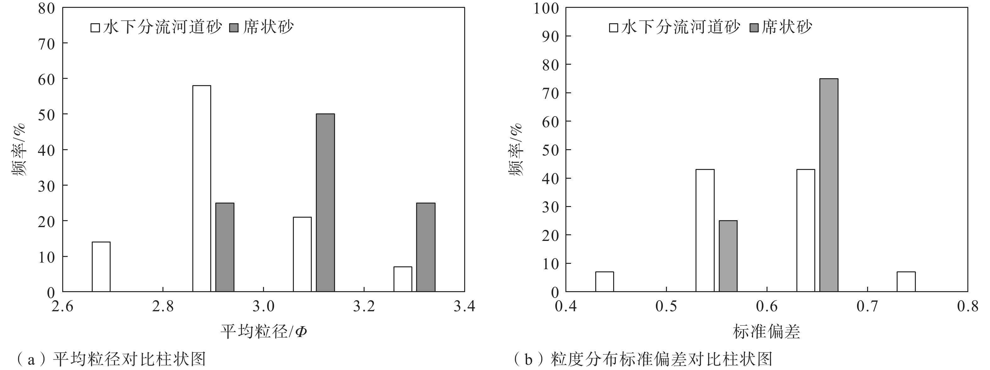
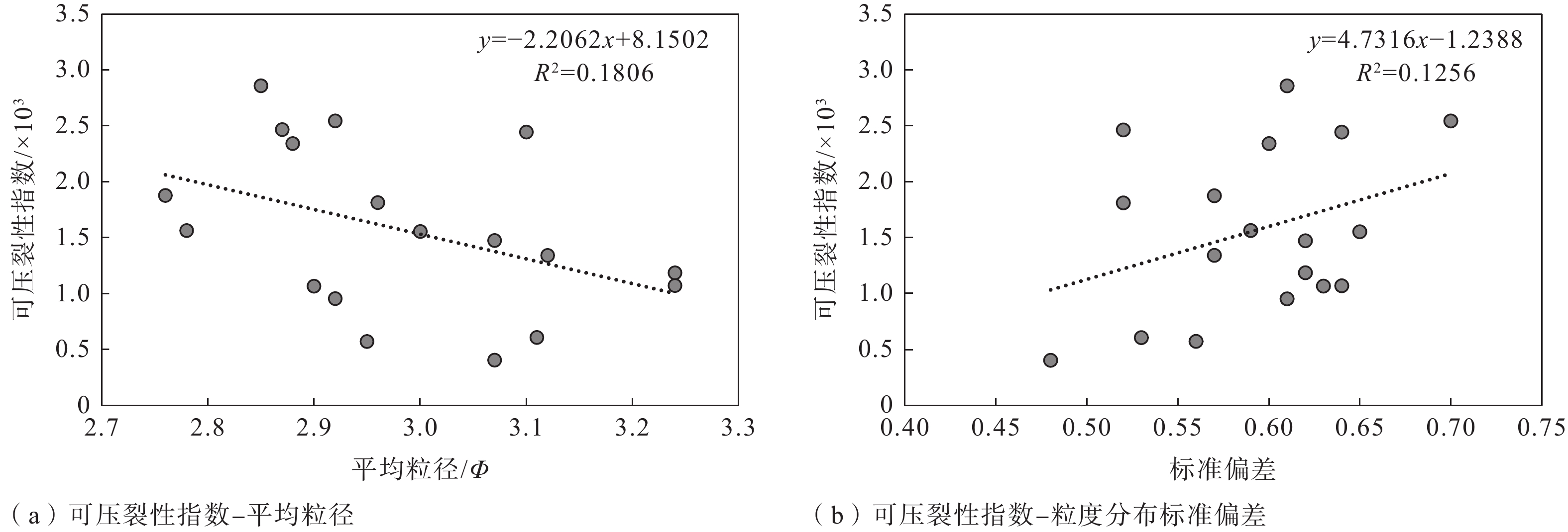
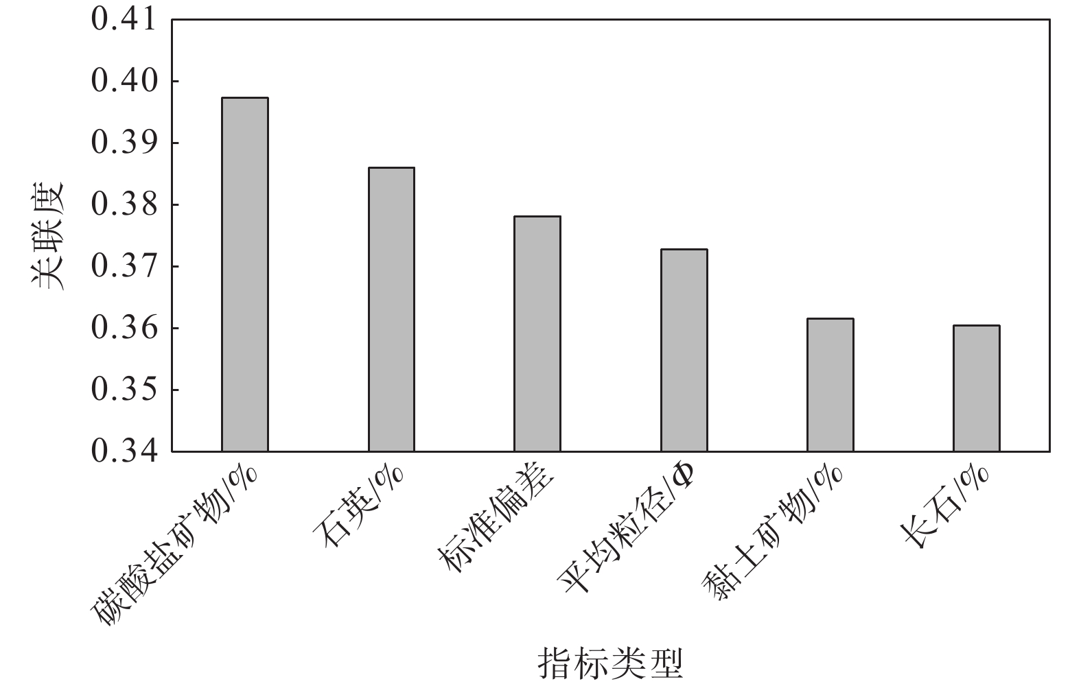
  Objective  Sedimentary differences are the key factor in controlling reservoir heterogeneity. Analyzing reservoir heterogeneity through sedimentary microfacies is crucial for oil and gas field development and sweet spot prediction, and it also informs the evaluation of fracturing in tight sandstone reservoirs. There are many types and complex lithologies of unconventional oil and gas reservoirs in the Ordos Basin as well as many factors controlling reservoir fracability. At present, mechanical experiments are used to comprehensively characterize the fracturing property; however the research cost is high and the experimental process is complicated, making it unnsuitable for large-scale oilfield development and use. Therefore, this study attempted to analyze and compare the fracability of tight sandstones with different sedimentary microfacies from the perspective of sedimentary microfacies controlling the lithology and reservoir development to provide a reference for oilfield development plans.   Methods  Taking the compact sandstone of Chang 7 member of Yanchang Formation in the Longdong area of Ordos Basin as the research object, the different types of microfacies are identified through the data of core and cast slice, the mineral composition and structural parameters of rock samples were obtained by X-ray diffraction (XRD) analysis, and rock mechanics experiments were conducted to quantitatively described the fracturing property.  Results  The results are as follows: (1) Two sedimentary microfacies, namely underwater distributary channel and sheet sand, mainly developed in Chang 7 Member of Yanchang Formation in the study area. Among them, the single sand body thickness of the underwater distributary channel is greater than 2 m, the sheet sand is mostly a medium thin and thick sand mudstone interlayer, and the single sand body thickness is generally less than 2 m. (2) The composition and structure of the two sedimentary sandstone microfacies are obviously different: the content of carbonate minerals, clay minerals, and heterobases in the sheet sand microfacies are relatively high, the particle size is finer, and the sorting is worse, which are the main internal factors that cause the difference in tight sandstone fracability and are the basis for judging the fracability of tight sandstone by sedimentary microfacies. (3) The fracability index was related to the composition and structure of sandstone. In terms of composition, the fracability index was positively correlated with quartz mineral content as well as carbonate mineral content and negatively correlated with feldspar mineral content. In terms of structure, there is a negative correlation between the fracability index and the average particle diameter φ. The larger the particle size, the higher the fracability index. The fracability index was positively correlated with the standard deviation of the particle size, indicating that the worse the particle separation, the higher the fracability index. (4) Through grey correlation analysis, it was found that the degree of influence of sandstone parameters on fracability was in the order of carbonate mineral content, quartz content, standard deviation of particle size, and average particle size from high to low, while clay minerals and feldspar content were in a relatively weak position.  Conclusion  The results indicate that the higher the contents of carbonate and quartz and the higher the standard deviation of particle size (the worse the sorting), the better the fracability. The finer the particle size, the higher the feldspar content and the worse the fracability. Grey correlation analysis showed that the carbonate mineral content, separation and particle size play a major role in the fracability of tight sandstone. Compared with distributary channel microfacies, sheet sand has a higher carbonate minerals content, worse sorting, and little difference in quartz content. Although the microphase particle size of the sheet sand is slightly finer, the average particle size has a relatively minor effect on the fracability; thus, sheet sand as a whole shows better fracability.   Significance  Since the standard deviation (sorting) and particle size of sandstone particles are controlled by sedimentary microfacies, and the content of carbonate minerals is directly controlled by sandstone thickness and indirectly affected by sedimentary microfacies, the change in the tight sandstone fracability index can be judged according to the difference in sedimentary microfacies in practical engineering, and the working process can be simplified.
Geo-hazards & Engineering Geology
Quaternary Geology & Environment
Active Tectonics & Earthquake
Fundamental Geology & Regional Geology
Research Express
Recognition of earthquake tsunamis records during the Northern Song Dynasty in Puqian Bay, Hainan Island
WANG Chaoqun, SUN Dongxia, YANG Xiaoxiao, ZHANG Yaoling, Jia Liyun, ZHANG Lei, Han Jian’en, HU Daogong
2024, 30(6): 1028-1030. doi: 10.12090/j.issn.1006-6616.2024121
Abstract (204) HTML (49) PDF (3372KB)(38)
Abstract:
Inside Back Cover
Inside Back Cover
2024, 30(6)
Abstract (49) PDF (4050KB)(7)
Abstract:
Inside Front Cover
Inside Front Cover
2024, 30(6)
Abstract (46) PDF (4050KB)(11)
Abstract:
Cover Page
Cover Page
2024, 30(6)
Abstract (72) PDF (3935KB)(17)
Abstract:
Contents
Contents
2024, 30(6): 1-2.
Abstract (69) HTML (36) PDF (462KB)(12)
Abstract:
Contents of Vol. 30
Contents of Vol. 30
2024, (6): 1030-1030.
Abstract (41) HTML (27) PDF (385KB)(6)
Abstract:
Crustal Stress & Tectonic Stress Field
Exploration and application of in-situ stress estimation method based on core disking phenomenon of boreholes
YAN Shaokun, WANG Chenghu, GAO Guiyun, LIU Jikun, DAI Xiangqian
2024, 30(6): 865-877. doi: 10.12090/j.issn.1006-6616.2023196
Abstract (391) HTML (62) PDF (2032KB)(72)
Abstract:
  Objective  Rock core disking is a typical phenomenon that occurs in environments with high in-situ stress. The geometric characteristics and section shape of rock disking are related to the state of in-situ stress, and the site where this phenomenon occurs may be unsuitable for measuring in-situ stress. To obtain more comprehensive in-situ stress data from a wider range of sources, according to this phenomenon, in-situ stress estimation is conducted based on the internal relationship between the in-situ measurement data and the original in-situ stress, and the obtained result can supplement the in-situ stress measurement data.   Methods  According to the relevant hypotheses and theories worldwide, the change in core section stress and core internal energy during the core disking phenomenon was analyzed. The physical and geometric characteristics of the disked rock cores were measured, combined with the stress state of the original rock, and an in-situ stress estimation formula based on core disking characteristics was constructed. The results were compared with those of the other formulas.   Results  The geometric characteristics of 73 representative rock disks in the 30–120 m depth section of the Dalianshan borehole in Dandong, Liaoning Province, where the phenomenon of rock core disking occurs, are measured, and the physical properties of the core are tested. The value of the in-situ stress in this section is estimated using the established in-situ stress estimation formula to supplement and perfect the measured hydraulic fracturing data and better reveal the law of in-situ stress variation.   Conclusion  This section is estimated according to other in-situ stress estimation formulas based on the phenomenon of core disking proposed by scholars worldwide; the calculated results either deviate from reality or are dispersed in the distribution. Compared with these formulas, the in-situ stress data estimated by this formula are more in line with reality and meet the stress conditions for the generation of core disking.   Significance   The results show that the results obtained using this method can complement and perfect the in-situ stress data of the core disking depth section.
Spatiotemporal evolution of interseismic coupling and stress accumulation near an asperity on a vertical strike-slip fault: Insights from three-dimensional viscoelastic numerical simulation
LI Yebo, HUANG Luyuan, YAO Rui, TIAN Yiwei, YANG Shuxin
2024, 30(6): 878-892. doi: 10.12090/j.issn.1006-6616.2023134
Abstract (291) HTML (42) PDF (1578KB)(60)
Abstract:
  Objective  Understanding the kinematic state and stress accumulation near fault protuberances is crucial for accurate assessment of earthquake hazards. Interseismic coupling (ISC) is a widely used method for characterizing the kinematic behavior of faults. Despite its importance, the correlation between the spatial distribution of ISC and the positioning of fault asperities, areas of increased frictional resistance, has not been extensively studied. Furthermore, the influence of the rheological properties of Earth materials on the temporal and spatial evolutions of slip deficits and shear stress accumulation in close proximity to these asperities remains poorly understood.   Methods  We developed a set of three-dimensional (3D) elastic and viscoelastic finite element models to investigate the effects of fault asperities on interseismic deformation and stress accumulation. These models incorporate vertical strike-slip faults and use sophisticated contact algorithms to simulate the mechanical locking associated with asperities. Our innovative approach, referred to as the “binary fault-locking approach”, simplifies fault behavior into a binary system, categorizing states as either “locked” or “unlocked”. The present study analyzes the spatial and temporal variations in the ISC and shear stress accumulation rates around a single asperity, providing novel insights into the mechanics of fault systems. In addition, we validate the efficacy of the “binary fault-locking approach” by applying it to the Xianshuihe fault, thereby reinforcing the relevance of our findings to real-world fault behavior. Through this study, we aim to enhance our understanding of fault mechanics and improve earthquake hazard assessments, which ultimately contributes to more effective risk-mitigation strategies.   Results  Because of the mechanical locking of the asperity, a fault-sliding surface within a certain distance from the asperity cannot slide freely, resulting in a slip deficit in an area centered around the asperity. Consequently, the degree of fault-locking displays a ring-shaped attenuation pattern centered on this asperity. Under purely elastic conditions, the ISC and shear stress accumulation rates near the vicinity of the asperity remained constant over time. Conversely, under viscoelastic conditions, the contours of the ISC and shear stress accumulation in the areas surrounding the asperity expanded with time under loading, and the effects of temporal changes in the locking degree became more pronounced. In scenarios where the viscosity differs on either side of the fault, the interseismic deformation and stress accumulation rate of the fault are primarily controlled by the rheological properties of the material on the side with a lower relaxation time, owing to the different relaxation times on either side of the fault.   Conclusion  (1) Because of the continuity of the medium, although the region adjacent to an asperity is not fully locked, its slip velocity is still lower than the movement velocity of block, resulting in a spatial pattern of decreasing ISC outward from the fault asperity. (2) Viscoelastic effects regulated the deformation near a fault asperity, leading to an increase in the spatial extent of the ISC over time. (3) The ISC can serve as an approximate indicator of the shear stress accumulation rate. Irrespective of viscoelastic effects, a value of approximately 0.5 can be used as the threshold for moderate to strong locking, and shear stress accumulation is insignificant below this value. (4) Considering the spatially nonuniform fault coupling along the Luhuo-Kangding segment of the Xianshuihe fault, the simulated surface velocities closely matched the GPS observations, thus confirming the reliability of the method.   Significance  This study establishes an important connection between ISC and shear stress accumulation rate, providing valuable insights for identifying potential seismic hazards. Overall, this study emphasizes the intricate interactions between fault dynamics and geological structures, and highlights the significance of detailed modeling for understanding earthquake mechanisms. By addressing the gaps in knowledge regarding the influence of protuberances on fault behavior, this research contributes valuable information to the field of seismic hazard estimation, thereby enhancing our ability to effectively mitigate earthquake risks.
Geo-hazards & Engineering Geology
Spatial structure characteristics and formation mechanism of the ancient Deda landslide elucidated using the microtremor survey method in Sichuan Province, China
QIU Zhendong, GUO Changbao, YANG Zhihua, WU Ruian, YAN Yiqiu, ZHANG Yiying, JIN Feng, CHEN Wenkai
2024, 30(6): 906-920. doi: 10.12090/j.issn.1006-6616.2023183
Abstract (533) HTML (67) PDF (7258KB)(71)
Abstract:
  Objective  The topography and geological structure of the eastern Qinghai-Tibet Plateau are highly complex. High development density and intricate spatial structures of large ancient landslides in alpine canyon areas, such as those in the Jinsha River, contribute to this complexity. In addition, hazards resulting from creep deformation and the resurgence of these ancient landslides are severe. The ancient Deda landslide, situated in Deda Township, Batang County, Sichuan Province, is a significant ancient landslide influenced by the Chalong-Ranbu fault activity. The spatial structural characteristics of this ancient landslide are complex, with localized resurgence deformation at the landslide front.   Methods  Various methods were included in the current study, such as remote sensing interpretation, on-site investigations, the microtremor survey method (MSM), and engineering geological drilling to elucidate further the spatial structural characteristics of the ancient Deda landslide.   Results  The research revealed that the ancient Deda landslide can be divided into three sections in the plan view: the Deda I landslide (I), the Deda II landslide (II), and the rear wall of the ancient Deda landslide (Ⅲ). Using MSM combined with drilling verification, a scheme for classifying the shear wave velocities of shallow and deep sliding zones was constructed, with a relative error in sliding zone depth identification ranging 2.6% ~ 4.8%. This paper showed that the Deda I landslide features two sliding zones, with a burial depth of 18.7 ~ 20.1 m for the shallow sliding zone (S1-1) and 36.2~49.9 m for the deep sliding zone (S1-2). The volume of the Deda I landslide is approximately 8.7×10⁶ ~ 12.0×10⁶ m3. The Deda II landslide has one sliding zone (S2) with a 25.2 ~ 38.6 m burial depth and a landslide volume of approximately 6.3×10⁶ ~ 9.6×10⁶ m3.   Conclusion  A comprehensive analysis suggested that the formation of the ancient Deda landslide was the result of various factors, including fault structures, rainfall infiltration, and river erosion. The complex landslide structure and its genesis were identified as the primary controlling factors for landslides in a state of creep deformation. [Significance] The research methods and insights presented in this study can serve as a reference for the spatial identification and risk prevention of large ancient landslides on the eastern Qinghai-Tibet Plateau.
Analysis of soaking deformation characteristics of large-thickness discontinuous collapsible loess
LIU Jianlei, WEI Tongyao, HUI Hanbin, JIANG Yaofei
2024, 30(6): 921-932. doi: 10.12090/j.issn.1006-6616.2023174
Abstract (349) HTML (58) PDF (3814KB)(30)
Abstract:
  Objective  The unique stratigraphic structure of the widely distributed discontinuous loess stratum in the Guanzhong Plain area of China results in significant differences between the indoor calculated values and field-measured values of the self-weight wetting amount for evaluating the foundation’s wetting property.  Methods  Indoor wetting tests and large-scale test pit immersion tests were carried out on-site to compare the factors influencing the difference between on-site and indoor wetting amounts, with the loess stratum on the north bank of the Weihe River as the research object.  Results  The following results were obtained from the study: (1) The ratio of self-weight wet depressions between field and indoor test was less than 0.1. This discrepancy was due to the discontinuity and inhomogeneity of loess layers, sampling disturbances in indoor tests, and differing immersion conditions in field test. (2) The “layer bow effect” caused by the discontinuity of loess was the main reason for the difference between the indoor and field tests. This effect weakened upward-transmitted deformation, hindered downward-transmitted gravity stress, and caused discontinuity in the percolation process. (3) Stratification calculations for the four test sites showed that most of the gravitational self-wetting in the field tests occurred in the Qp3 soil layer, while the Qp2 loess layer showed large difference between the field-measured and indoor test values. Thus, the Qp2 loess layer has little to no wetting effect.  Conclusion  The shape of the saturated zone range obtained through numerical simulation was consistent with the field test results, and the numerical simulation method was more advantageous for observing the experimental results. When calculating wet subsidence by self-weight, a stratification method based on the strata age can be used. For the Qp3 stratum, the correction coefficient method specified in the guidelines was chosen, while the Qp2 loess stratum was determined by an on-site pit immersion test.  Significance  The research methodology used in this study provides theoretical guidance for future engineering constructions on the Guanzhong Plain.
Quaternary Geology & Environment
Formation and evolution of the Yuncheng Salt Lake and sources of the saline ions
KOU Linlin, LI Zhenhong, XIA Caixiang, WEI Lijie, DONG Xiaopeng, WANG Sen, CUI Jiawei, HUANG Ting, NAN Debin
2024, 30(6): 933-951. doi: 10.12090/j.issn.1006-6616.2024003
Abstract (706) HTML (71) PDF (4734KB)(59)
Abstract:
  Objective  Yuncheng Salt Lake, located within the core area of the Fenwei Graben System in the south-central part of the North China Craton, is the earliest known salt lake in China and worldwide. The formation and evolution of the Yuncheng Salt Lake are closely related to the Cenozoic tectonic domains of the coastal Pacific in eastern China and the Qinghai-Tibet Plateau in western China. However, there are many debates regarding the spatiotemporal processes and key timing associated with these two domains in the Yuncheng Salt Lake. Additionally, the salt lake is rich in sodium, magnesium, chloride, and sulfate ions; however the sources of these saline ions remain unclear.   Methods  This study investigated the major changes in the Cenozoic tectonic geomorphology of the Yuncheng Basin and its surrounding areas, focusing on the evolution of the Cenozoic river-lake system to establish the formation and evolution stages of the Yuncheng Salt Lake. This study combined the tectonic background and geochemical element analysis of typical strata in the adjacent Zhongtiao Mountains to identify the main sources of saline ions in the Yuncheng Salt Lake.   Results  At the boundary between the Paleogene and Neogene, there was a widespread angular unconformity across the central and eastern parts of the North China Craton. This unconformity affected the Weihe Basin in the Fenwei Graben System to the west, and not the northeastern edge of the Qinghai-Tibet Plateau, which connects to the western North China Craton. This indicates that the tectonic forces during this period originated mainly from the coastal Pacific tectonic domain of the eastern North China Craton. In the mid-Miocene, a widespread unconformity along the northeastern edge of the Qinghai-Tibet Plateau connect to the western North China Craton. The northeastward uplift and expansion of the Qinghai-Tibet Plateau affected caused the Ordos Basin to rotate counterclockwise, initiating the formation of the Shanxi Graben System within the Fenwei Graben System. The Cenozoic evolution of the Yuncheng Salt Lake is the result of the interaction between the two major tectonic domains of eastern and western China. Before the mid-Miocene, the coastal Pacific tectonic domain predominantly controlled the region. Subsequently, the long-distance effects of northeastward uplift and expansion of the Qinghai-Tibet Plateau began to influence the Yuncheng Salt Lake. The Jixian System Longjiayuan Formation in the Zhongtiao Mountain area is composed of marine carbonate deposits that is the primary source of magnesium ions for the salt lake, with an average magnesium oxide content of 20.92%. The Paleogene Pinglu Group, an arid lake basin deposit rich in gypsum layers, provids sodium, chloride, and sulfate ions to the salt lake, with an average sodium oxide content of up to 2.6%.   Conclusion  This study suggested that approximatedly 700000 years ago, during the transition between the early and middle Pleistocene, the Yellow River flowed eastward into the sea through the Sanmenxia Gorge, leading to the disappearance of the Sanmen paleolake and the initial formation of the Yuncheng Salt Lake. Approximately 70000 years ago, during the mid-late Pleistocene, the Fen River changed its course and left the Yuncheng Basin, transforming the salt lake from an open to a closed system, ultimately forming the Yuncheng Salt Lake. Subsequently, under the continuous influence of the fault at the northern edge of the Zhongtiao Mountains, a large sedimentary depression formed, accumulating a large amount of saline minerals. Natural salt lake is formed over long periods of precipitation and evaporation. Currently, the saline ions of the Yuncheng Salt Lake mainly originate from adjacent sedimentary strata in the Zhongtiao Mountains and deep mineralization layers. The major fault controlling the salt lake provides the upward migration and injection of saline substances from deep mineralization layers into the salt lake. The marine high-magnesium dolomite of the Longjiayuan Formation of the Mesoproterozoic Jixian System in the Zhongtiao Mountains is a major source of magnesium ions for the salt lake.   Significance  The research findings provide fundamental geological evidence for the implementation of an ecological protection strategy to restore the lake by reducing salt levels in Yuncheng Salt Lake.
Quaternary strata lithological characteristics and environmental geological significance of borehole WKZK01 in the eastern Songnen Plain
CHEN Yangyang, YANG Ke, YU Junbo, ZHANG Qipeng, YANG Zhiwei, QIAO Shaozhong, LIU Jiacheng, LIU Xue, WANG Chenchen
2024, 30(6): 952-964. doi: 10.12090/j.issn.1006-6616.2023149
Abstract (256) HTML (48) PDF (1513KB)(52)
Abstract:
  Objective  Study of the Quaternary stratigraphical characteristics of the eastern Songnen Plain is of particular importance for gaining an understanding of regional climate change and the evolution of sedimentary environments. To data, however, there has been comparatively little research focusing on the Quaternary strata in this area, which has accordingly limited our comprehension of the mechanisms underlying changes in the regional climate and environment.   Methods  In this study we focused on the borehole WKZK01 in the eastern Songnen Plain. On the basis of lithological characteristic analysis, we obtained dating, sedimentary environment evolution, and climatic evolution information using optically stimulated luminescence, palynology, and laser grain size analytical methods, and based on comparisons with the results obtained from a typical Huangshan section, Harbin, we discuss the Quaternary stratigraphy of the borehole and the sedimentary environments it reflects.   Results  The Quaternary strata in Wangkui county are divided from old to new as follows: the middle Pleistocene Huangshan Formation, the middle Pleistocene Harbin Formation, and the upper Pleistocene Guxiangtun Formation, with an absence of a Holocene Tantu Formation. The Huangshan Formation is 13.05 m thick, with a median grain size (Md) ranging from 7.77 μm to 11.84 μm, and an average value of 9.62 μm. Pollen zone I-1 is dominated by xerophytic herbaceous pollen, with small amounts of mixed coniferous and broadleaf woody plant pollen, although lacks pollen derived from hydrophilic herbaceous plant. The Harbin Formation is 24.05 m thick, with a median grain size (Md) ranging from 9.67 μm to 14.98 μm, and an average value of 11.74 μm. Pollen zone I-2 is still dominated by xerophytic herbaceous pollen, with that derived from mixed coniferous and broadleaf woody plants as the secondary component, and the appearance of hydrophilic herbaceous plant pollen. The Guxiangtun Formation is 15.6 m thick, with a median grain size (Md) ranging from 11.61 μm to 19.91 μm, and an average value of 14.12 μm. Compared with the earlier stages, pollen zone II has a less abundant pollen content, although is characterized by an increase in hydrophilic herbaceous pollen, and a marked decline in the content of pollen derived from xerophytic woody and herbaceous plants.  Conclusion  The Huangshan Formation represents lacustrine deposits, with pollen zone I-1 providing evidence of a cool and dry climate during the early Middle Pleistocene. The Harbin Formation also comprises lacustrine deposits, with the pollen record in zone I-2 indicating a cool and humid climate during the late Middle Pleistocene. The Guxiangtun Formation comprises fluvial deposits, with pollen zone II recording a cold and wet climate during the Late Pleistocene.   Significance  The borehole WKZK01 provides a record of the environmental evolution of a small lake adjacent to the large Songnen paleolake, revealing a transition from the lake center to the margin and eventually disappearing with the formation of rivers.
Active Tectonics & Earthquake
InSAR deformation observation and regional severe earthquake hazard analysis of the 2016 and 2022 strong earthquake activities in Menyuan, Qinghai
CHENG Yan, JIANG Yanan, HOU Zhongjian, ZENG Rui, LUO Huiyuan
2024, 30(6): 965-977. doi: 10.12090/j.issn.1006-6616.2023197
Abstract (231) HTML (36) PDF (5022KB)(34)
Abstract:
  Objective  Over the past 30 years, Menyuan Country, Qinghai, has experienced three strong earthquakes, demonstrating active seismic activity. The focal mechanisms of these earthquakes showed remarkable differences and the epicenters were all located near the Lenglongling fault.   Methods  In order to quantitatively analyze the activity characteristics of the Menyuan seismic sequence using InSAR technology to obtain the coseismic deformation field of the Menyuan earthquake of 2016 and 2022 and establish an appropriate fault model, the fine slip distributions of the two earthquakes were obtained through steepest decent method (SDM). Furthermore, the static Coulomb stress changes on the faults in the region and its surroundings caused by the Menyuan Mw 6.6 earthquake in 2022 were evaluated.   Results  The coseismic deformation field in 2016 exhibited a single elliptical uplift center, with predominantly thrust motion. In contrast, the spatial distribution of the deformation field in 2022 was more complex, showing a Y-shaped distribution, and there was a slight variation in the rupture direction from west to east, with primarily horizontal deformation.  Conclusion  The two earthquakes also differed in their slip patterns and shallow and deep structural styles. In 2016, the seismic activity was weak, with a slip zone existing at depths between 8 km and 12 km, where the maximum slip was only 0.23 m. The fault plane had a low inclination angle, which is a characteristic of deep-seated slip. By contrast, the 2022 earthquake was a typical shallow-focus earthquake featuring three distinct slip areas. The primary rupture occurred in the Lenglongling section, concentrated in the shallow part from 1 km to 7 km, with a maximum displacement of 3.22 m. A significant slip also occurred along the western extension of the Lenglongling fault, reaching a maximum slip of 2.59 m. The Tuolaishan section experienced rupturing mainly between 3 km and 8 km, with the maximum slip recorded as 2.1 m.  Significance  Combined with the analysis of the Menyuan earthquake activity in 1986, it is inferred that the Menyuan earthquake sequence is dominated by the activity of the Lenglongling fault, which is continuously adapting to new structures and stress adjustments in its northeast extension and shows compressive-shortening activity trend. The 2022 Menyuan Mw 6.6 earthquake had a significant impact range, and earthquake hazards need to be continuously monitored and studied further, especially in areas where static Coulomb stress changes exceed the hazard threshold.
Tectonic deformation and seismic mechanism of the 2021 Aksai MS 5.5 earthquake
ZOU Xiaobo, LI Xingjian, SHAO Yanxiu, YUAN Daoyang, QIU Jiangtao, YIN Xinxin, KOU Junyang
2024, 30(6): 978-990. doi: 10.12090/j.issn.1006-6616.2023125
Abstract (224) HTML (37) PDF (8478KB)(49)
Abstract:
  Objective  On August 26, 2021, an Ms5.5 earthquake occurred in Aksai, Gansu Province. The epicenter is located along the southern piedmont of the Danghe Nan Shan. This event garnered significant attention because of its deformation characteristics and seismogenic mechanisms. Existing studies have mainly focused on emergency response and seismic activity analyses; however, there is a lack of research on tectonic deformation and seismic mechanisms. This study aimed to fill this gap by analyzing the deformation characteristics of the earthquake zone and revealing its seismogenic mechanism.   Methods  This study employed seismological methods combined with interferometric synthetic aperture radar (InSAR) technology to investigate the tectonic deformation and seismic mechanism of the 2021 Aksai Ms5.5 earthquake. Combining focal mechanism solutions, precise earthquake locations, and InSAR results, the seismogenic fault and its geometric and kinematic parameters were determined and validated through geological field surveys.   Results  This study applied joint inversion with both local and teleseismic waveforms (the generalized cut-and-paste joint, gCAPjoint) to source parameters. The fault solutions strike 315°, dip 41°, rake 81°, depth 6.9 km. We relocated the Aksai earthquake and its aftershocks using the hypoinverse and double-difference method (HypoDD), and accurate locations of 88 earthquakes were obtained. The 2021 Ms5.5 earthquake sequence in Aksai is distributed near the southern Danghe Nan Shan Fault, with a fault dip toward the NE. The co-seismic deformation field indicated by InSAR matched the macro-epicenter with the precise location results, confirming the reliability of the precise location. Both the ascending and descending orbit surface deformation fields showed uplift near the epicenter with similar magnitudes and signs in the line-of-sight direction, indicating that the earthquake rupture was mainly thrusting. Fault scarps near the epicenter along the southern piedmont of the Danghe Nan Shan were recognized in the field and satellite images. Combined data from focal mechanism solutions, precise earthquake locations, and InSAR coseismic deformation fields, along with field geological survey results, indicate that the seismogenic fault of this event was the southern Danghe Nan Shan Fault, with a strike of 315°, dip of 41°, and rake of 81°.  Conclusion  This study indicated that the seismogenic fault of this event was the southern Danghe Nan Shan Fault, which is a thrust fault. The fault solutions strike 315°, dip 41°, rake 81°, depth 6.9 km. Because of the northward extrusion thrust of the Qinghai-Xizang Block, the seismic activity in the northern part of the Qaidam Block has significantly increased. The future seismic risk of the eastern section of the Altyn Tagh Fault and western Qilian Shan should be emphasized. [ Significance ] This study provides new insights and methods for researching active tectonics. It holds significant scientific importance and innovation in understanding seismogenic mechanisms and structural transformation, as it helps to understand the mode and magnitude of slip transfer between the strike-slipping of the Altyn Tagh Fault and the shortening of the Qilian Shan and also contributes to a better evaluation of the seismic risk in this region.
Fundamental Geology & Regional Geology
Geochemical characteristics of apatite in metabasic rocks under different metamorphic conditions: a case study from the Paleoproterozoic Trans-North China Orogen
YANG Yuqing, GAO Peng, ZHANG Jian, LIU Xiaoguang, CHENG Changquan, YIN Changqing, QIAN Jiahui
2024, 30(6): 991-1011. doi: 10.12090/j.issn.1006-6616.2024046
Abstract (312) HTML (57) PDF (5382KB)(70)
Abstract:
  Objective  Apatite is a common accessory mineral that is widely distributed in various rock types. Its U-Pb age, trace elements (particularly REE, Th, U, and Sr), and Sr-Nd isotopic compositions provide important information on its chronology and magmatism. However, the geochemical behavior at different metamorphic levels during orogenesis remains unclear. As a typical continent-to-continent collisional orogenic belt in the Paleoproterozoic, the Trans-North China Orogen (TNCO) has recorded an integrated metamorphic sequence ranging from greenschist to amphibolite to granulite facies. Therefore, it is an ideal area to study the geochemical behavior of apatite during various grades of metamorphism involving the orogenic process.   Methods  In this study, we systematically collected metabasic samples of different metamorphic grades, including greenschist, amphibolite, and mafic granulite, in the Wutai-Hengshan area of the TNCO. We conducted detailed petrographic observations and geochemical analyses of apatite grains from metabasic rocks with different metamorphic grades.   Results  Our results showed that the apatite grains from the greenschist samples had both magmatic and metamorphic origins. The apatite grains in the amphibolite samples were mainly of metamorphic origin. In contrast, the grains from the granulite samples were closely related to crustal anatexis, exhibiting geochemical characteristics of magmatic-origin apatite.  Conclusion  This study shows that trace element variations in apatite can clearly reflect the influence of metamorphic grades, crustal anatexis, and coexisting rock-forming minerals with variations in temperature and pressure conditions during metamorphism.   Significance  The results of this study provide new constraints to our understanding of elemental migration and the geochemical balance within apatite during orogeny.
Zircon U-Pb dating of the Dizhuanggou Formation, Changjiaoba Group in the South Qinling Belt and its tectonic significance
LIU Zhihui, LIU Xiaochun, CHEN Longyao, ZHENG Guanggao, HU Juan
2024, 30(6): 1012-1027. doi: 10.12090/j.issn.1006-6616.2024027
Abstract (245) HTML (36) PDF (3231KB)(50)
Abstract:
  Objective  The Changjiaoba Group, located in the Foping area of the South Qinling Belt, is one of the few poorly-studied strata in the belt. The lack of an accurate composition and formation age of these strata has restricted research on the tectonic affinity and evolution of the South Qinling Belt.  Method  This paper investigates the petrological characteristics and zircon U-Pb chronology of two metasedimentary rocks from the Dizhuanggou Formation of the Changjiaoba Group.  Results  The results show that the dominant peak detrital zircon dates of the two samples were approximately 810–835 Ma, with the youngest date range being approximately 600–700 Ma, indicating that the maximum depositional age was Neoproterozoic. This age spectrum differs significantly from that of the most exposed Devonian Heilongtan Formation of the Changjiaoba Group, but is highly similar to that of another sample from the Foping Group, which has a minimum age peak of 718 Ma and a major peak at 810 Ma. In addition, metamorphic zircons from the Dizhuanggou Formation and the Foping Group yielded ages of 207 Ma and 193 Ma, respectively.  Conclusion  The distinct depositional age of the Changjiaoba Group indicate the complexity of its composition. Combined with the petrological and field geological features, the Dizhuanggou Formation and a Neoproterozoic strata of the Foping Group are considered to form the transitional basement of the western South Qinling Belt. This is comparable to the transitional basement of the Wudang and Yaolinghe Groups east of the Ningshan Fault in the South Qinling Belt.  Significance  The identification of Neoproterozoic and Mesozoic materials in the Changjiaoba Group provides a new basis for the division of metamorphic units in the Foping area, identifying three units with different degrees of layering and metamorphism, which, in turn, facilitates understanding of the Mesozoic orogenic process in the South Qinling Belt.