2023 Vol. 29, No. 1

Cover
Cover
2023, 29(1)
Abstract (176) PDF (157KB)(64)
Abstract:
Contents
Contents
2023, 29(1): 1-2.
Abstract (325) HTML (107) PDF (436KB)(63)
Abstract:
Tectonic System & Structural Geology
The outline of the Proterozoic South China Ocean
YANG Minggui, YAO Yue, XIONG Ran, WANG Guanghui, HU Qinghua, XU Meigui
2023, 29(1): 1-20. doi: 10.12090/j.issn.1006-6616.2021051
Abstract (584) HTML (172) PDF (16118KB)(131)
Abstract:
The geological circle has been studying the South China Ocean for 40 years. Based on the existing studies, the geological features of the middle Neogene South China Ocean and related geological structures and mineralization issues have been further understood through the topics of Regional Geology of China: Jiangxi, Mineral Geology of China: Jiangxi, and Evolution and Mineralization in South China Ocean–Marginal Pacific. The Pingxiang–Shexian–Suzhou junction zone connects the Jinsha River–Red River junction zone to the north of Henei, which is the subduction zone of the South China Ocean in the middle Neogene. It formed the boundary between the Yangtse plate and the newly-defined China-Southeast Asia plate (referred to as the Jinsha River–Red River–Shexian–Suzhou junction zone), which is now a latitudinal tectonic belt bending southward. The South China Ocean is a Meso-Neoproterozoic ocean between the Yangzi Paleo-plate and the Cathaysia-Southeast Asia Paleo-plate, closed at about 820± Ma. The Jinning movement took place during the collision of the plates, resulting in a consolidation of the Yangtze Block and the Cathaysia-Southeast Asia Block, where they united into one. The region has been an essential part of the Eurasian plate since the Indo-Chinese period, and the South China Rift System had been formed from 815± Ma in the late Neogene to the early Paleozoic. The Tethys and Paleo-Pacific tectonic domains have formed the geological tectonic framework of southern China and plateaus, continents, seas, and island arcs of the neighboring areas since the late Paleozoic. The subduction zone of the South China Ocean has evolved into the “Jinsha River–Hong River–Qinzhou Bay–-Hangzhou Bay” mega metallogenic belt of tungsten-tin-copper-gold polymetallic precious and rare metals, featuring two major magmatic mineralization series of S and I types.
Crustal Stress & Tectonic Stress Field
The methods of fracture prediction based on structural strain analysis and its application
GAO Chenyang, ZHAO Fuhai, GAO Lianfeng, LI Bingxi, LEI Maosheng, DING Kai
2023, 29(1): 21-33. doi: 10.12090/j.issn.1006-6616.2022089
Abstract (616) HTML (170) PDF (15418KB)(147)
Abstract:
Formation strain can directly affect the generation of structural fractures. According to the magnitude of structural strain, the location and intensity of structural fracture development can be predicted, and the chief fracture development areas in the study area can be divided. This paper takes the fourth member of the Yingcheng formation (referred to as the YING-4 section) in the Xuzhong area of the Xujiaweizi rift in the Songliao basin as the research object. Based on establishing a detailed 3D structural model of the study area, we used the “structural restoration” method to restore the paleo-structure of the study area and calculated finite strain values to predict the planar distribution of structural fractures. The research shows that the YING-4 section in the study area mainly includes three fracture-making periods, namely the end of the Yingcheng formation, the Quantou–to–Qingshankou formation, and the Nenjiang formation. Among them, the tectonic deformation at the end of the Yingcheng formation and the Quantou–to–Qingshankou formation is relatively strong, which is the main formation period of the fracture. The study area is divided into three types of fracture development zones according to the relationship between strain size and test gas production. Type I fracture development zone has been verified by well-drilling, indicating that the prediction results of fractures using structural strain are reliable. Type Ⅱ fracture development zone can be used as an important direction for the next step of deep natural gas exploration. Type Ⅲ fracture development zone has low productivity, and the fractures have limited effect on reservoir reconstruction.
Ore Field Structure & Mineralization
Sedimentary facies characteristics and metallogenic model of the lower Cambrian Maidiping formation in the Huangjiaping phosphate deposit, Mabian County, southern Sichuan
LI Zuoqiang, CHEN Min, LU Junyong, YANG Kailong, TANG Maolin, ZHU Rongtao
2023, 29(1): 34-47. doi: 10.12090/j.issn.1006-6616.2022051
Abstract (578) HTML (208) PDF (12523KB)(84)
Abstract:
The lower Cambrian Maidiping formation in the Mabian area of southern Sichuan is a crucial ore-bearing horizon for Kunyang-style phosphate ores. The sedimentary paleoenvironment controls the distribution of phosphate ore. Based on the field section measurements and borehole core observations of the phosphorus-bearing strata of the Maidiping formation in the Huangjiaping area of Mabian, the characteristics of the sedimentary phases, phosphate massifs, and the mode of phosphate ore genesis of the Maidiping formation were studied in detail. The study shows that the Maidiping formation has developed carbonate tidal flat sedimentary facies, and six micro-phases can be identified in three subphases: supratidal flat, strand flat, and subtidal flat. The supratidal flat includes supratidal beach and supratidal dolomite flat; the strand flat includes tidal channel, intertidal beach, and intertidal limestone flat; the subtidal flat is only developed with the low-energy subtidal flat, showing a sedimentary evolution sequence of sea recession and sea erosion in the vertical direction. Based on the finding, we established the bay–tidal flat depositional model in the Maidiping formation. The sedimentary facies strictly controls the enrichment of phosphorite, and the intertidal beach and tidal channel with high energy hydrodynamics in the strand flat is the most favorable environment for phosphorite formation. The sand–gravel phosphorite is the most widely developed phosphorite type in the Mabian area. The mineralization mode of phosphate deposits is that the rising ocean current brings phosphorus-rich seawater into the tidal flat environment of the bay, and the phosphorus condenses and accumulates in the form of colloid-chemical, by biological and chemical interactions, forming semi-solidified and weakly-solidified phosphate sediments, which are then subjected to water scouring, crushing, transporting, and precipitation again, and then formed into high-grade phosphate masses after compaction and consolidation.
Application of EH4 in deep concealed rock (ore) body detection: A case study of the Donglufang copper-molybdenum polymetallic deposit, Shangri-la, China
LI Zhong, ZHANG Xiaobing, WANG Jinming, XIAO Gaoqiang, ZHANG Yourong, DUAN Zhaoyan
2023, 29(1): 48-59. doi: 10.12090/j.issn.1006-6616.2022037
Abstract (351) HTML (173) PDF (13681KB)(76)
Abstract:
This study uses the method of Audio-frequency magnetotelluric sounding (EH4) to detect and analyze the deep geological structure in the Donglifang mining area. The underground spatial electricity and structural characteristics were effectively determined. We built an EH4-based indicator system for localizing ore bodies and summarized the relationship between the apparent resistivity anomalies and the ore bodies in the EH4 profile. The shallow veined or columnar low-resistance bodies may correspond to the low–medium temperature hydrothermal gold, lead, and zinc polymetallic ore bodies; the columnar medium-resistance or medium–low resistance bodies correspond to the silica or porphyry copper–molybdenum polymetallic ore bodies; the medium-resistance bodies correspond to the medium acidic magmatic rocks (porphyrites and porphyries). We identified eleven concealed ore bodies in the deep of the mine area, five of which are consistent with the drill holes, and the remaining six have an excellent prospect of finding ore bodies. It is further inferred that larger-scale porphyry copper–molybdenum ore bodies are formed in the deep rock body. This study proves that the EH4 is an effective geophysical method for finding concealed rock (ore) bodies in the Dongxuofang copper-molybdenum polymetallic mine or this type of deposit.
Geochemical characteristics of the garnets from the Laodonggou gold deposit, Beishan, Inner Mongolia
TANG Weidong, HE Jiale, LIU Tianhang, WEI Liyong, FAN Baocheng, ZHAO Fudong, HE Yi, GUO Yongchao, YANG Bing
2023, 29(1): 60-75. doi: 10.12090/j.issn.1006-6616.2022098
Abstract (380) HTML (141) PDF (26162KB)(47)
Abstract:
The Laodonggou gold deposit is a medium-sized gold deposit discovered in the eastern section of the Beishan metallogenic belt. It resulted from the superposition of multi-phase and multi-stage metallogenesis. Due to its complex deposit genesis, the deposit has five sections, of which skarn orebodies dominate Section III. Skarn minerals are mainly garnet, which can be divided into early and late phases, with early garnet having more oscillatory ring bands. We systematically studied the two types of garnet by detailed microscopic observation and electron microprobe. The core of the early garnet primarily consists of essonites, and the edge is calcium–iron to calcium–aluminum composition. Andradites dominate the late garnet. The chemical composition of garnet indicates that the early skarnization stage is under a moderately acidic and weakly oxidizing–to–weakly reducing hydrothermal environment, while the iron content increases in the later stage and the oxygen escape increases, resulting in increased alkalinity and oxidation. The garnets in Section Ⅲ, originating from hydrothermal metasomatism, belong to the andradite–essonite series. Essonites and andradites prevail in the early stage, accompanied by copper mineralization. With the late hydrothermal environmental changes, andradites increase, and pyrite mineralization and arsenopyrite mineralization increase as well, resulting in gold-rich mineralization.
Dating the Deli Pb–Zn deposit, Xidamingshan mining district, South China: Implications for regional exploration
HU Lijuan, WU Xiangke, LE Xingwen, YU Shuqing, ZHANG Linyan, ZHU Yiguang, CEN Wenpan
2023, 29(1): 76-86. doi: 10.12090/j.issn.1006-6616.2022034
Abstract (380) HTML (195) PDF (5135KB)(71)
Abstract:
The Youjiang basin is a diamond-shaped Indosinian foreland basin formed during the subduction and merging of the South China plate into the Indo-Chinese plate. A large number of Indo-Chinese tectonic traces have been preserved in the basin. However, little has been reported about the syn-tectonic magma and its related mineralization in the basin. Sphalerites from the newly discovered Deli Pb–Zn deposit in the Xidamingshan mining district at the southeastern margin of the Youjiang basin were sampled for the Rb–Sr isochron dating. We obtained the isochron age of 207.1 ± 0.6 Ma (MSWD = 1.5) with initial Sr isotopic composition of 0.728379 to 0.739226. The Sr isotopic compositions are distinct from those of the Late Cretaceous felsic intrusions and the Late Jurassic high-Mg andesite in or around the Xidamingshan district but similar to those of the Late Triassic granites in the Guangxi province. The results indicate that the ore-forming age of the Deli Pb–Zn deposit may be closely related to the concealed Triassic granite. The Si–Ca fracture zone between the Devonian and Cambrian is a favorable location to search for Pb–Zn deposits in the Xidamingshan mining district. This work proves the Triassic Pb–Zn mineralization has occurred in the Xidamingshan mining district and Late Cretaceous magmatic-hydrothermal Bi–W–Zn–Pb–Ag mineralization in the west of it. It provides new ideas and directions for future exploration in the Xidamingshan mining district.
Geo-hazards & Engineering Geology
Applying stream power gradient in the investigation on spatial susceptibility of debris flow: A case of the Jinsha River Basin, China
GU Zhenkui, YAO Xin, LI Lingjing, TAO Tao
2023, 29(1): 87-98. doi: 10.12090/j.issn.1006-6616.2022022
Abstract (691) HTML (138) PDF (55976KB)(90)
Abstract:
Investigation of spatial susceptibility of debris flow is a basis for carrying out geological hazard prevention and developing ecological restoration plans. It is difficult to efficiently and accurately identify potential debris flow gullies on a large spatial scale simply by relying on field surveys combined with remote sensing observations or debris flow simulations with small watersheds as units. Taking the Jinsha River Basin of China as an example, we propose a quantitative scheme to describe the intensity of extrinsic forces by calculating the stream power gradient (ω). We extracted gullies prone to debris flow, assuming that there is no spatial heterogeneity in the provenance supply conditions based on the fundamental understanding that debris flow is a high-energy gravity flow. In the situation where the threshold (ω=1×10⁻⁴ W/m²) is the mutational site of the gradient change trend of the relation curve between the number of debris flow gullies and ω value, a total of about 32 thousand debris flow gullies with lengths of more than 200 m were found. In the middle and lower reaches of the basin, these gullies are located within a 30-kilometer buffer zone along the Jinsha and Yalong Rivers, and there is a power function relationship between the number of debris flow gullies and the width of a buffer zone. However, extreme weather events are likely to increase in the future under global warming, and these areas should be the critical prevention areas of debris flow disasters, especially the cascade reservoir area. The results of this study provide a lattice data set of spatial locations of the gullies prone to debris flow and the stream power gradients in the Jinsha River basin, which can be used to retrieve the exact location of the high-energy gullies and can also be used as the basic data for the study of related geological hazards and surface processes in general.
Research on an effective rainfall model for geological disaster early warning in Fujian Province, China
CHEN Chunli, FANG Zhiwei
2023, 29(1): 99-110. doi: 10.12090/j.issn.1006-6616.2022090
Abstract (428) HTML (141) PDF (3018KB)(61)
Abstract:
Rainfall is one of the most important external factors inducing geological disasters, especially prominent in China’s mountainous regions. Many group-occurring geological disasters induced by heavy rainfall occurred in southeast China’s middle and low mountainous regions, causing many casualties and property losses. Taking Fujian Province as an example, we carefully examined the actual rainfall data of historical geological disaster cases and conducted correlation studies on typical rainfall processes inducing group-occurring geological disasters based on quantitative rainfall estimation with county-level administrative districts as the statistical unit. We also carried out a partial correlation analysis based on quantitative indicators of the geological environment for verification. The result shows that the occurrence of geological disasters in Fujian correlates with adequate rainfall within three days, and it is reduced by a reduction coefficient of 0.79 daily. Based on that finding, we established an effective rainfall model for Fujian Province and verified it through field monitoring and early warning applications. Applying this rainfall model to geological disaster early warning in Fujian can reduce the warning area, lower the warning level, shorten the warning duration, and improve the accuracy of geological disaster early warning by maintaining the hit ratio. The results of the study can help to characterize the rainfall accurately and can provide a scientific basis for the reasonable assessment of rainfall factors in regional geological disaster early warning.
InSAR-based indentification and spatial distribution analysis of active landslides in the Western Sichuan Plateau
LIU Xinghong, YAO Xin, YANG Bo, TANG Wenkun, ZHOU Zhenkai
2023, 29(1): 111-126. doi: 10.12090/j.issn.1006-6616.2022024
Abstract (502) HTML (163) PDF (17340KB)(140)
Abstract:
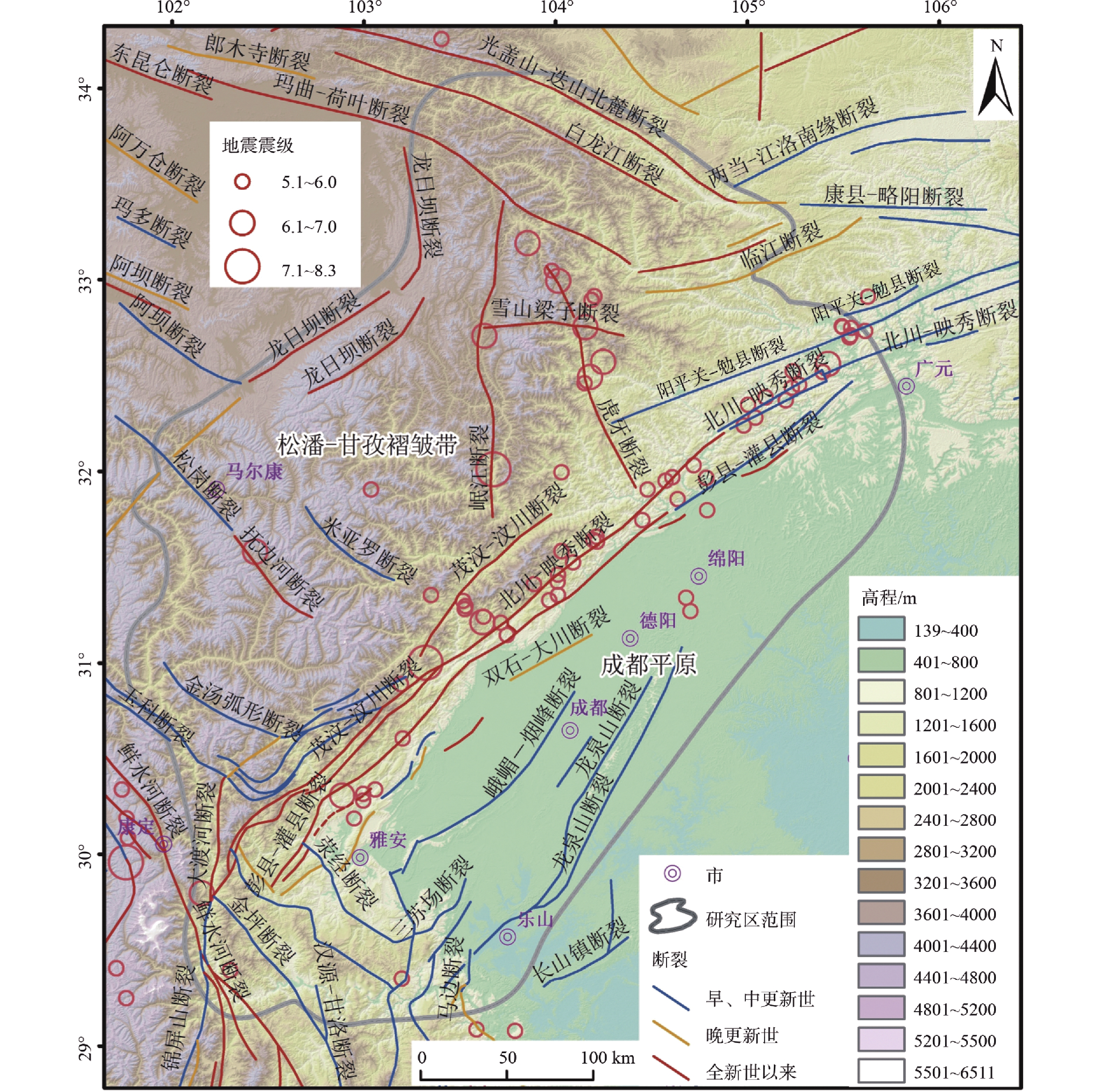
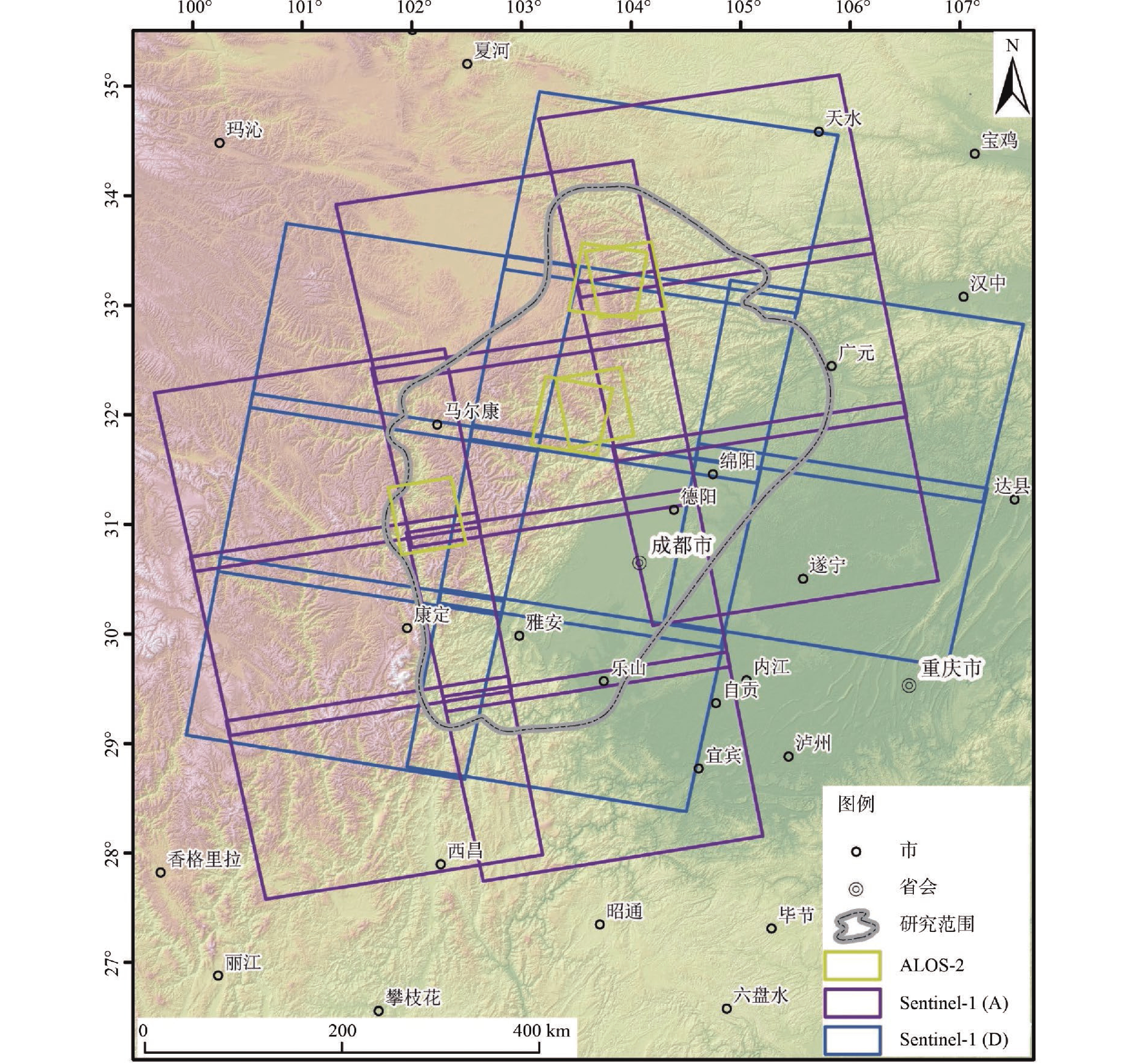
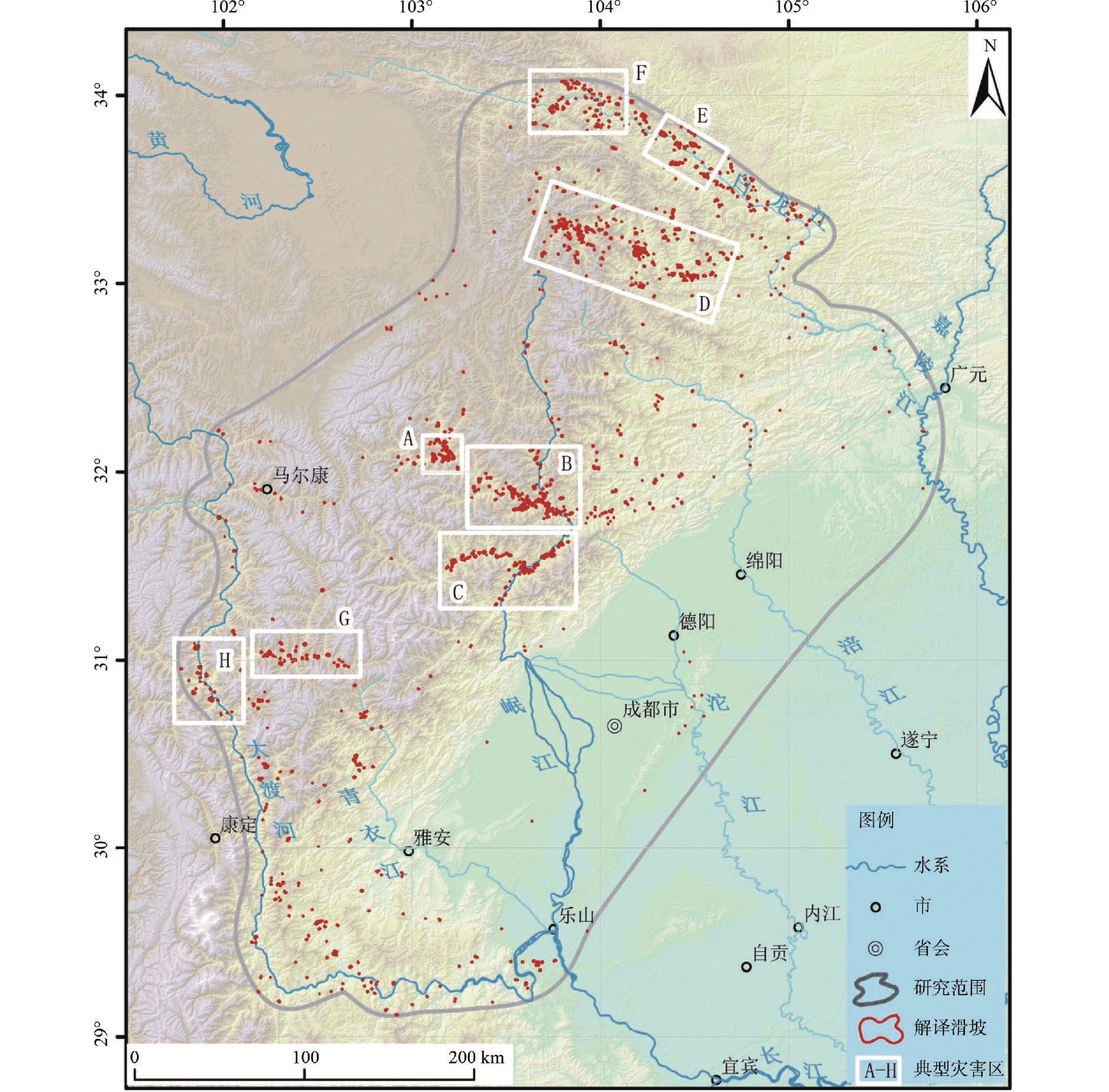
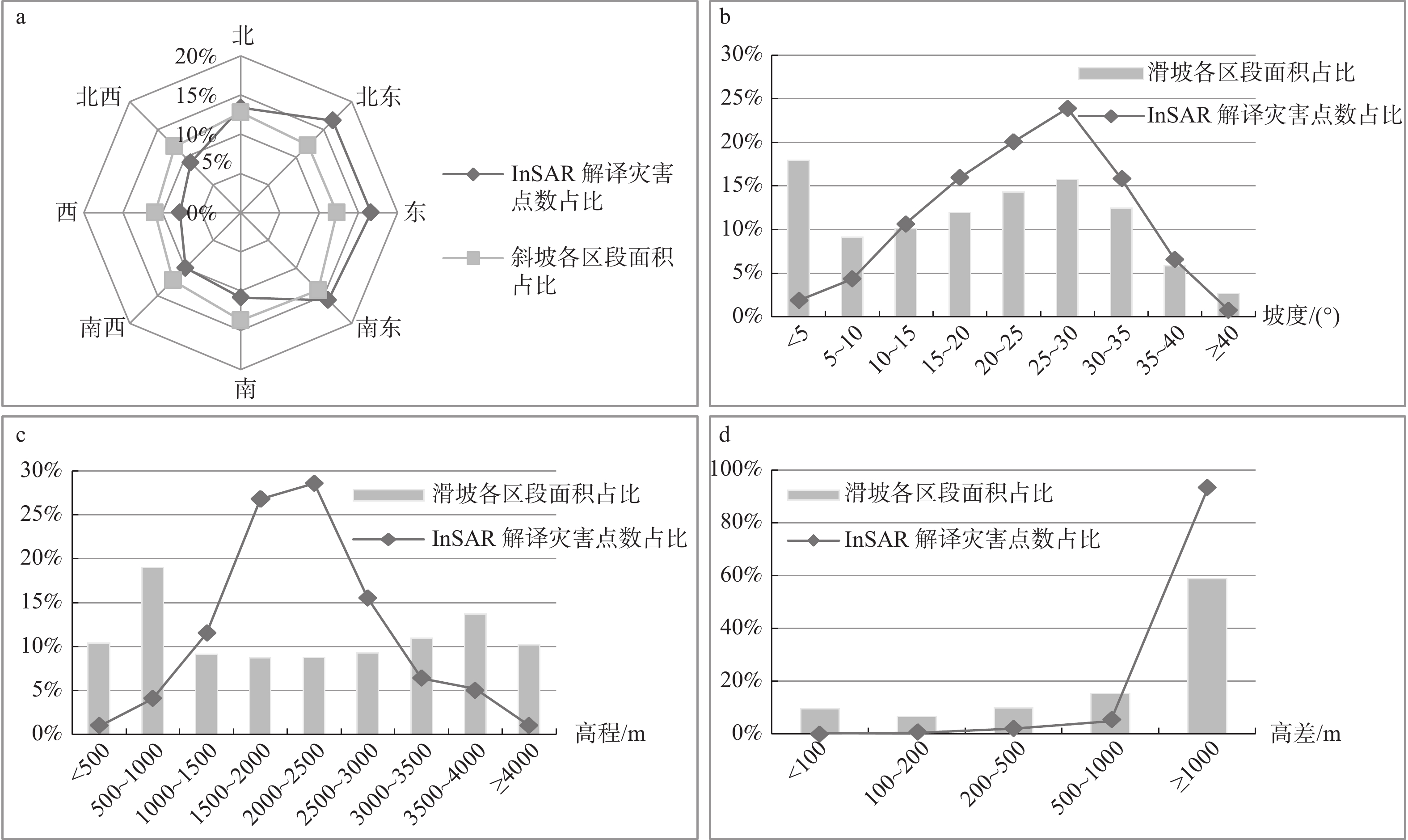
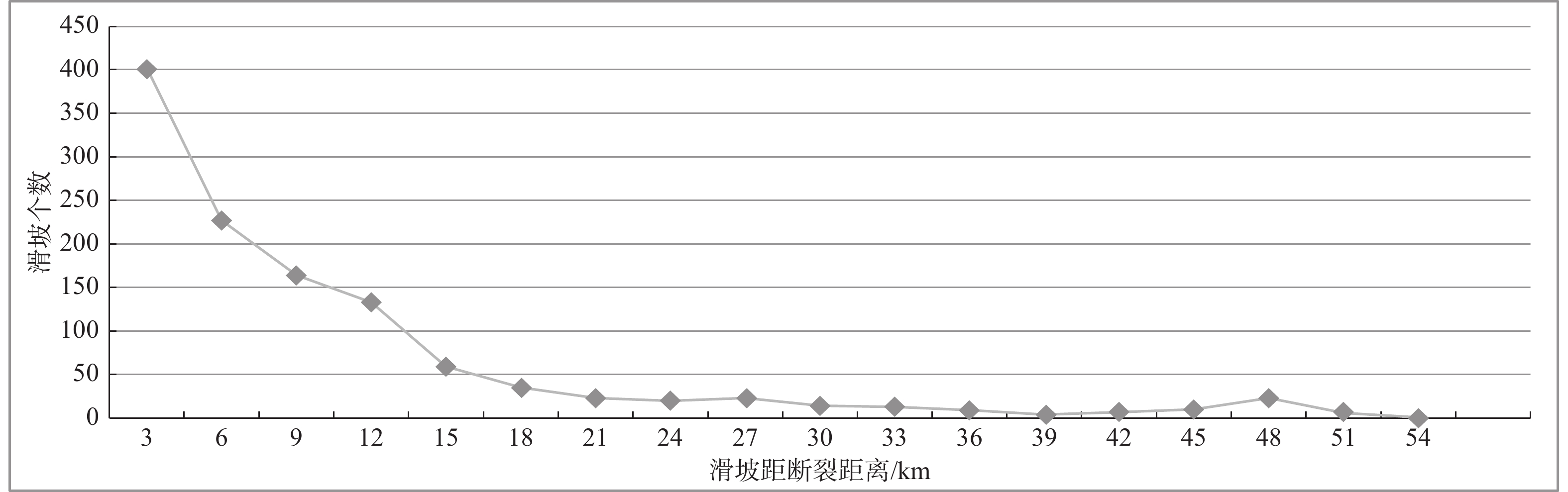
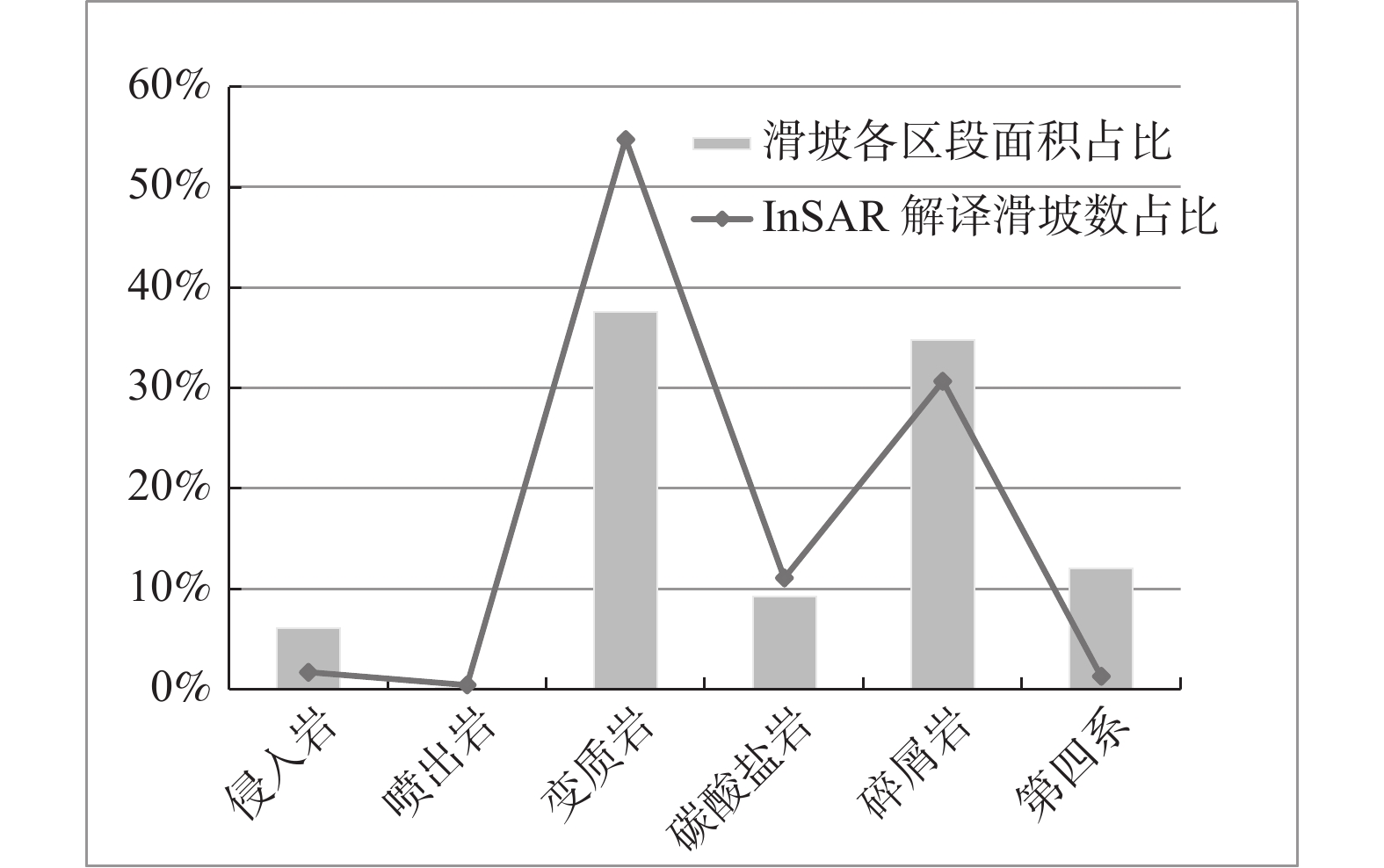
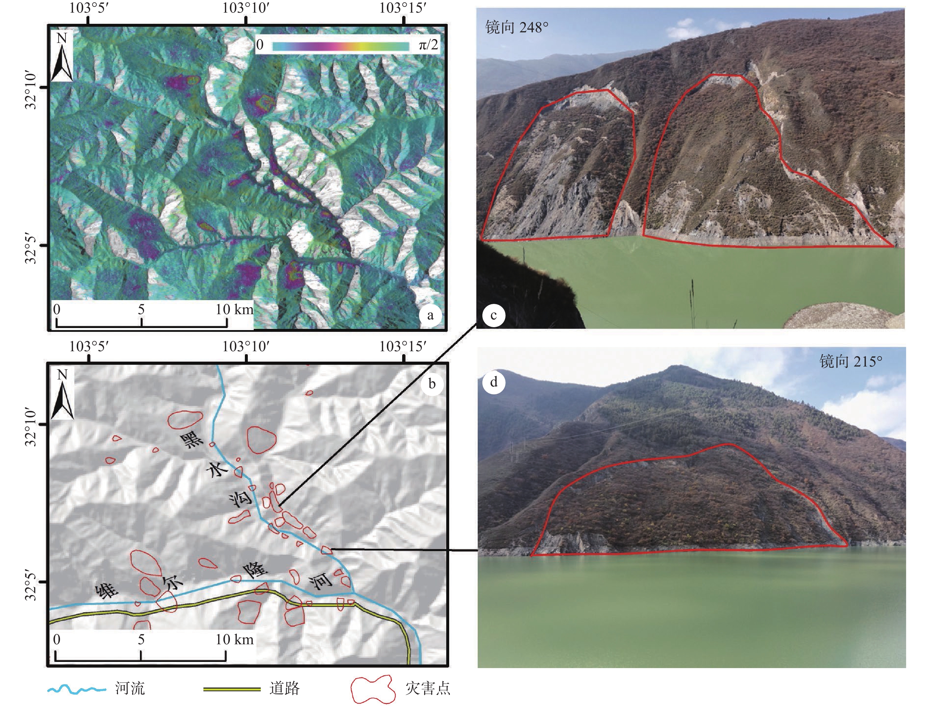
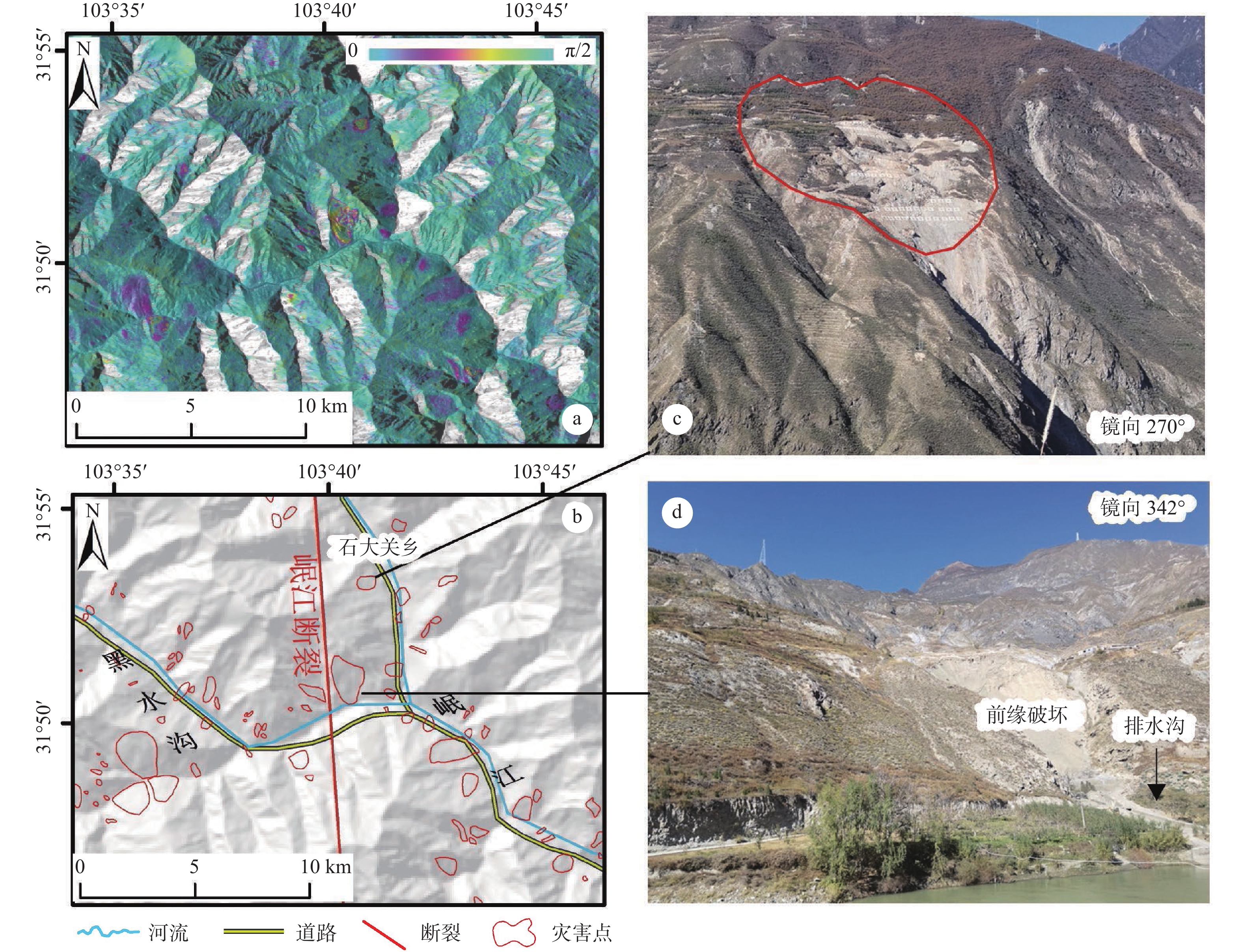
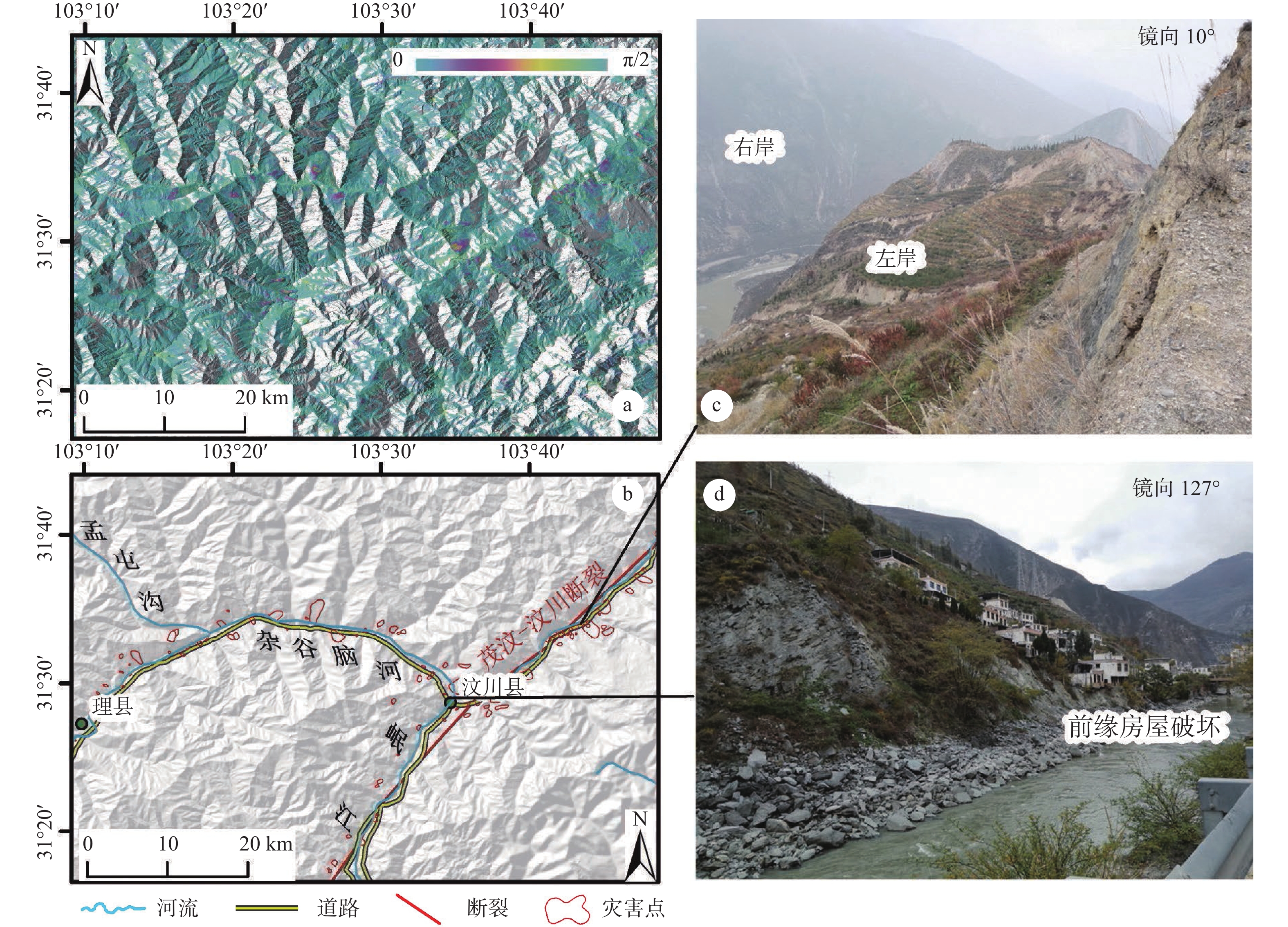
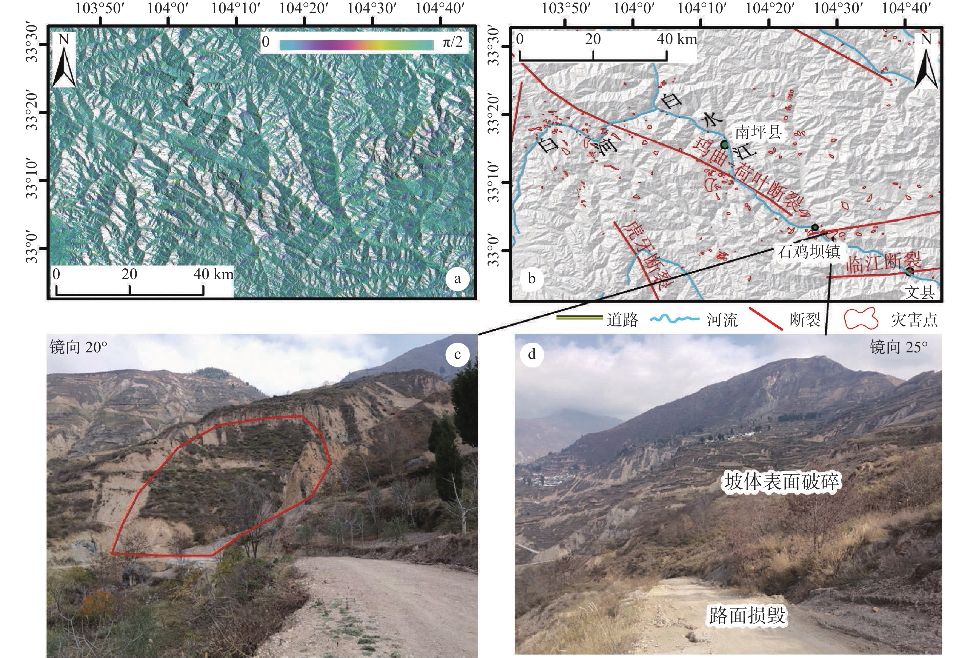
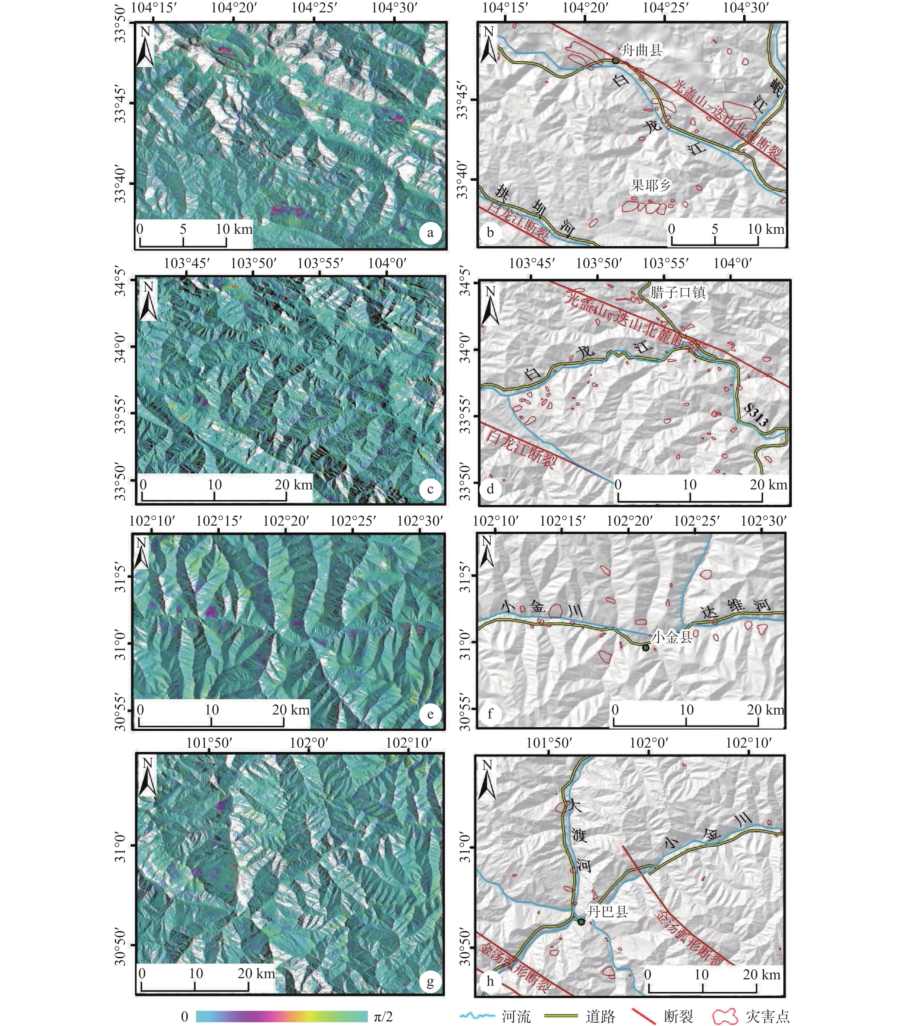
The Chengdu plain westward to the Songpan-Ganzi fold belt is a transition zone from basin to plateau. The region has huge undulation and fall, strange and steep terrain, severe river undercutting and erosion, frequent tectonic activities, and strong internal and external dynamics, resulting in frequent earthquakes and numerous geological hazards. The article uses Sentinel-1A data covering the whole region and ALOS-2 data in key areas for InSAR technology processing, combined with GIS spatial analysis, early identification of active landslide disasters in the study area and exploration of spatial distribution patterns, supplemented by field surveys to support the following understanding. According to the inducing factors of the disaster, the areas where the disaster points are concentrated can be divided into three zones: disaster zones induced by reservoir storage, such as Maoergai Reservoir in Heishui County; disaster zones caused by broken mountains after the earthquake, such as the junction of Minjiang River and Heishui Gully in Maoxian County, the area from Wenchuan County to Li County, and the area from Jiuzhaigou County to Shijiba Town; disaster zones cause by essential rivers, such as Zhouqu County, Lazikou Town, Xiaojin County, and Danba County. The active landslides in the region are mainly distributed in metamorphic rocks such as phyllite and clastic rocks such as shale. The disasters are mainly distributed in the terrain with aspects of SE, E, NE, slope greater than 15°, elevation interval of 1000~3000 m, relative elevation difference greater than 1000 m, and curvature between −0.5~0.5. The disaster points are mainly close to the Minjiang fault, the Tazang fault, the Guanggaishan-Northern Dieshan fault, and the Maowen-Wenchuan fault zone. The combination of orbit-ascending and orbit-ascending data of Sentinel-1A increases the effective observation area to 73.41% of the total area. The ALOS-2 data are relatively better than the Sentinel-1A data in the western Sichuan plateau area. The coincidence rates of ALOS-2 and Sentinel-1A are 58.7% and 44.8%, respectively, in Jiuzhaigou and Maoxian, and the identified number of the former is 3.98 times and 1.39 times that of the latter.
Quaternary activity characteristics of the Qionghua–Liantang fault belt in Hainan
YANG Xiaoxiao, HU Daogong, JIA Liyun, WANG Chaoqun, SUN Dongxia, ZHANG Lei
2023, 29(1): 127-137. doi: 10.12090/j.issn.1006-6616.2022020
Abstract (581) HTML (234) PDF (10567KB)(133)
Abstract:
The Qionghua–Liantang fault belt, located at the boundary between the Fushan depression and the Haikou uplift, is the result of the impact of the uneven extension of the NE-trending Beibu Gulf rift. The Qionghua–Liantang fault belt passes through the Changliu New District and the major projects of the island-looping high-speed railway in Haikou, directly impacting the planning and construction of the Hainan Free Trade Zone. The article uses tectonic geomorphic survey, geophysical exploration, and drilling exploration to reveal that the Qionghua–Liantang fault consists of three NW-trending buried and semi-buried normal faults, which are the Wuyuanhe–Daoxincun fault (F1-1), the Yongzhuangshuiku fault (F1-2), and the Haikouzhuanwachang fault (F1-3). The width of the Qionghua–Liantang fault belt is about 1.8 km, and the length is about 17 km. The vertical displacement of the fault belt is 8.7~41.6 m since the Quaternary. The latest active age of these three faults is the late Pleistocene; the vertical activity rate was less than 0.1 mm/a. It is worth noting that the vertical activity rate of the Haikouzhuanwachang fault (F1-3) is higher than the other two faults and has more vigorous activity. Combining the tectonic background, the latest active age of the Qionghua–Liantang fault, and its relationship with Quaternary volcanic activity, this paper puts forward suggestions on the planning and construction of the Hainan Free Trade Zone and building avoidance of active fault.
Quaternary Geology & Environment
Evolution and changes of the ancient Luanhe fluvial fan since the Quaternary in Tangshan, Hebei Province
CHEN Hongqiang, ZHUAN Shaopeng, ZHAO Huaping, YANG Rui, CHEN Chao, DUAN Bingxin, LI Qingzhe
2023, 29(1): 138-152. doi: 10.12090/j.issn.1006-6616.2022023
Abstract (611) HTML (242) PDF (8473KB)(79)
Abstract:
The study of the ancient Luanhe alluvial fan has focused more on the Holocene, and no systematic study has been conducted on its Pleistocene evolution and variation. We studied the magnetic stratigraphy, chronostratigraphy, sedimentology, logging sedimentology, and core color of the boreholes PZK10 and PZK20 in the ancient Luanshe alluvial fan. Based on that, we carried out a comprehensive study of the Quaternary three-dimensional geological structure, the scale of the alluvial fan body, and the migration pattern of the ancient Luanshe alluvial plain. The borehole PZK10 recorded Brunches, Matuyama, and Gauss polarity chrons; the boundaries between them are 77.42 m and 71.50 m, respectively. The borehole PZK10 also revealed a set of diluvial “mud-gravel” layers deposited in the Pliocene, with two alluvial fan-lake phase cycles in the Early Pleistocene, braided river deposits in the Middle Pleistocene, and lake, alluvial fan and braided river facies in the late Pleistocene. A set of highly thick “mud-gravel” layers was deposited in the Pliocene of the borehole PZK20. The early Pleistocene is the fan-front–plain-braided river facies deposition, the middle Pleistocene is the braided river–alluvial fan facies deposition, and the late Pleistocene is the braided river deposition. Early Pleistocene, the ancient Luanhe River out of the mountain formed a large-scale alluvial fan in Shaliuhe town, which is the first stage of the ancient Luanhe alluvial fan. In the middle of the early Pleistocene, the ancient Luanhe River diverged in the current Qiuzhuang reservoir, and the alluvial fan formed in the Fengrun area, namely the second stage alluvial fan. In the middle Pleistocene, the first alluvial fan began to shrink, while the second alluvial fan continued to develop, forming a vast thick gravel layer. Late Pleistocene, the ancient Luanhe river was captured north of Qianxi county. It flowed eastwards and migrated out of the research area into the Qian’an basin in Xixiakou village, forming the alluvial fan with Xixiakou village as its apex.
Excellence Awards of 2022
2023, 29(1): 153-154.
Abstract (420) HTML (186) PDF (319KB)(89)
Abstract:
Inside Back Cover
2023, 29(1): 155-155.
Abstract (206) PDF (3359KB)(30)
Abstract:
Inside Back Cover
2023, 29(1): 156-156.
Abstract (178) PDF (3359KB)(20)
Abstract: