2023 Vol. 29, No. 2

Cover Page
2023, 29(2): .
Abstract (161) PDF (166KB)(40)
Abstract:
Contents
Contents
2023, 29(2): 1-2.
Abstract (145) PDF (408KB)(32)
Abstract:
Tectonic System & Structural Geology
Late Paleozoic-Mesozoic structural style, deformation sequence, and formation process and mechanism of the checkboard structure in the eastern Junggar Basin
REN Xincheng, XIU Jinlei, LIU Lin, LIU Dezhi, TAN Xingyu, ZHANG Beihang
2023, 29(2): 155-173. doi: 10.12090/j.issn.1006-6616.2022113
Abstract (762) HTML (231) PDF (48193KB)(129)
Abstract:

The eastern Junggar has experienced multistage intra-continental deformations since the late Paleozoic. The checkerboard structure is one of the most notable features of the Junggar Basin, especially the eastern Junggar Basin, and its formation and evolution is a microcosm of the intracontinental deformation within the Central Asian Orogenic Belt. However, it needs to be clarified how and when the checkerboard structure developed within the Junggar Basin. In this study, we focused on Permian-Cenozoic deformations around the Junggar Basin. We proposed that the deformation was mainly driven by plate margin interaction, especially by the Tethys tectonic domain. During the Late Permian, the Junggar Basin experienced the nearly EW-trending compression, which resulted in the overall deformation of the basin and the formation of a series of nearly N-S-trending thrust faults and related folds, laying the foundation for the chessboard structure of the eastern Junggar Basin and even the entire basin. The Junggar Basin and its surrounding basins experienced regional extension during the Early-Middle Jurassic. An important sinistral transtension event occurred in the northeastern and northwestern margins of the basin, forming the large-scale strike-slip duplexes. During the Late Jurassic, the eastern Junggar Basin experienced nearly E-W shortening, which resulted in the nearly N-S-trending folding of the pre-Jurassic strata and further strengthened the original N-S-trending folds and faults. The driving force for the Late Jurassic deformation may result from the Tethys tectonic domain to the south, which also caused a clockwise rotation of the Junggar Basin. During the Late Cretaceous, the eastern Junggar Basin experienced nearly N-S-trending shortening, which led to the deformation of the previous N-S-trending folds and faults and the finalization of the checkerboard structural style. During the late Cenozoic, the eastern Junggar Basin was affected by the far-field effect of the India-Eurasian collision, but the intensity and sphere were relatively weak.

Energy Resources Geology
Analysis of petroleum systems and assessment of petroleum resources in the West Barents Sea Basin, Arctic
LI Gang, WANG Ning, ZHANG Kaixun, BAI Guoping, HE Yubo, HU Jingjing, MENG Qiuhan, QIU Haihua
2023, 29(2): 174-187. doi: 10.12090/j.issn.1006-6616.2022134
Abstract (381) HTML (100) PDF (22896KB)(64)
Abstract:

The West Barents Sea Basin in the Arctic is one of the most promising petroleum basins in the world. With the latest data from the IHS database, this study investigated the petroleum geology of the basin, documented the distribution characteristics of petroleum resources, systematically analyzed the petroleum systems and plays, evaluated the resource potential, and predicted the favorable exploration fairways in the West Barents Sea Basin. The results show that regionally, discovered oil and gas accumulations are mainly distributed in the southwest area of the basin; stratigraphically, oil and gas reserves are mainly confined to the Jurassic and Triassic reservoirs, which host 72.6% and 15.5% of the total proved and probable reserves, respectively. The basin has two known petroleum systems: the Jurassic/Triassic composite petroleum system and the Permian/Carboniferous composite petroleum system. The resource evaluation by the Monte Carlo statistical methodology indicates that the means of undiscovered resources in the West Barents Sea Basin are 487.4×10⁶ t of oil, 1375.6×109 m3 of gas, and 84.6×10⁶ t of condensate, amounting to 1681.9×106 t, of which the gas accounts for 66.0%. Based on the results of resource evaluation and comprehensive analysis of petroleum geology, two favorable exploration fairways were selected: the favorable exploration zone of the Jurassic play and the favorable exploration zone of the Triassic play in the southern area of the basin.

A study of the sedimentary reservoir in the middle sub-member of the first member of the Liushagang Formation in the Weizhou-11A Oilfield, Beibu Gulf Basin
CHENG Yuehong, LI Mao, YU Xinghe
2023, 29(2): 188-201. doi: 10.12090/j.issn.1006-6616.2023011
Abstract (351) HTML (115) PDF (34952KB)(46)
Abstract:

The sedimentary lithology is complex in the middle sub-member of the first member of the Liushagang Formation(L1-M) of the Weizhou-11A oilfield in the southwest Weizhou depression of the Beibu Gulf Basin. The reservoir changes rapidly in both vertical and horizontal directions, and the distribution scale and connectivity are challenging to predict, which seriously affects the oilfield development effect. Through core observation and description, 3D-seismic analysis, rock grain size, lithofacies, logging facies, and modern deposit analogy analysis, it is believed that the depositional fluids control the sand bodies and reservoir types. Braided stream bottom-load deposits (St, Sp, Sr), sandy debris flow deposits (Gmg, Gn), and turbidity deposits (Fhn) can form favorable reservoirs, which are mainly distributed in the braided channel, braided flow bar, mouth bar and sheet sand microfacies of fan delta front. We discussed the spatial distribution law and geometric shape of sedimentary microfacies in four middle-term cycles and proposed five types and eight kinds of sand-body stack types and connectivity characteristics of the fan delta front. The reservoir model and the empirical values of width, thickness, and the width-to-thickness ratio of main sedimentary microfacies are established, which provide a scientific basis for the oilfield development.

Geo-hazards & Engineering Geology
Evaluation of landslide susceptibility in the gentle hill-valley areas based on the interpretable random forest-recursive feature elimination model
SUN Deliang, CHEN Danlu, MI Changlin, CHEN Xingyu, MI Shiwen, LI Xiaoqin
2023, 29(2): 202-219. doi: 10.12090/j.issn.1006-6616.2022128
Abstract (447) HTML (65) PDF (42802KB)(66)
Abstract:

This study aims to evaluate landslide susceptibility and explain the internal mechanism of gentle hill-valley through SHAP partial interpretation and PDP partial dependency map based on the random forest-recursive feature elimination model to provide references for geological disaster prevention and control. We used the optimized random forest algorithm to analyze the landslide susceptibility of the specific hill-valley areas and established a landslide susceptibility evaluation model. The recursive feature elimination algorithm was used to eliminate noise factors. Sixteen factors of four types, including terrain, geology, environmental conditions, and human activities, were selected to build a landslide hazard factor database for the Hechuan district. Then we combined 754 historical landslide sites in the Hechuan district with the factor database to derive a landslide susceptibility zoning map for the study area, and the factor importance was ranked using the random forest algorithm. Finally, a partial dependency plot is applied to explain the factors strongly influencing landslide occurrence in the Hechuan district and the SHAP algorithm for a local explanation of individual landslides. The results show that: compared with the original model, the AUC value of the test set of the random forest-recursive feature elimination model has increased by 0.019, demonstrating the effectiveness of the recursive feature elimination algorithm. According to the evaluation results of the random forest model, the AUC values of the training set and the test set are 0.769 and 0.755, respectively, with high prediction accuracy. The density is high in areas with large undulations, and historical landslides are concentrated in high-susceptibility areas. The spatial distribution of landslides is uneven and complex, and the influence of each hazard factor on landslide occurrence has prominent regional characteristics and spatial heterogeneity. In hill-valley areas, the average annual rainfall, elevation, and lithology are the most critical factors affecting landslide occurrence. According to the local interpretation map of SHAP, the landslide on the uphill road of Baitaping is explained. The lithology and elevation played a role in restraining the landslide, and the undulation, slope, NDVI, and POI kernel density promoted the landslide. In summary, the random forest-recursive feature elimination model has high accuracy in landslide susceptibility evaluation in the hill-valley areas. The interpretation and analysis of the internal mechanism of the regional landslides and individual landslides through PDP and SHAP interpretation algorithms are conducive to constructing and improving the evaluation factor system for landslide susceptibility under different geomorphic environments. The internal decision-making mechanism of landslides is explored; it can provide a reference for the regional landslide susceptibility assessment and geological disaster prevention.

Study on fault-slip potential induced by water injection in the deep thermal reservoir of the Gaoyang low uplift, Hebei Province
ZHU Siyu, CAO Jiawen, FENG Chengjun, WANG Jiming, MENG Jing, QI Bangshen, ZHANG Peng
2023, 29(2): 220-235. doi: 10.12090/j.issn.1006-6616.2022093
Abstract (310) HTML (91) PDF (22377KB)(35)
Abstract:

Recently, water injection-induced earthquakes caused by faulting instability have become a prominent geological safety issue for safely exploiting deep geothermal resources. This study investigates whether the future large-scale development of deep geothermal resources in the Gaoyang uplift will destabilize buried faults. There has a great amount of karst thermal reservoir in the Gaoyang low uplift, Hebei province. To find out whether the large-scale deep geothermal exploitation in the future will induce faults distributed in and around Gaoyang geothermal reservoir to become unstable, firstly, we calculate the initial stable state of the main buried faults based on Mohr-Coulomb criteria using the comprehensive in-situ stress field of North China; then, under Hsieh and Bredehoeft hydrological model, we calculate the possible excess pore pressure caused by water injection for 10~40 years at representative geothermal wells; subsequently, combing this perturbation with the initial stable state, we obtain the fault slip potential of the main buried faults from 2022 to 2062 based on a probabilistic approach; ultimately, we discuss the impact on the changes of fault slip potential due to varying angles between the maximum horizontal principal stress and the fault orientation. The main conclusions of this work can be drawn as follows. With the injection rate of 170 m3/h, the maximum excess pore pressure caused by a single geothermal well does not surpass 11 MPa, and it obeys a power decrease distribution with increasing distance from the center of the injection well; its influence scope is no more than 8 km. Continuous water injection strongly changes the stability of those buried faults distributed 2 km within the geothermal wells, and fault-slip potentials of some segmental faults even exceed 85%, corresponding to high unstable risk. Under 50 years of water injection at an injection well, the fault-slip potential of faults with different strikes within 2 km from the injection well increases rapidly with the declining angle among its orientation and the regional maximum horizontal principal stress. This paper's study methodology and associated findings can offer geoscientific justification for the safe exploration and exploitation of deep geothermal resources domestically and internationally. This study can provide a method reference for the location of injection wells and the selection of faults in different orientations in geothermal fields at home and abroad, thus promoting the safe and efficient development and utilization of geothermal resources.

Characteristics and slope structure of the Beishan landslide group in Tianshui City
WANG Haojie, SUN Ping, ZHANG Shuai, WANG Tao, REN Jian
2023, 29(2): 236-252. doi: 10.12090/j.issn.1006-6616.2022052
Abstract (696) HTML (193) PDF (77929KB)(107)
Abstract:

The Beishan area in Tianshui City is located in the transition zone between the mountainous area on the northern edge of the Qinling Mountains and the Loess Plateau. The solid internal and external dynamic coupling has induced large landslide groups with a zonal distribution, which seriously restricts urban planning and disaster risk prevention in Tianshui City. Based on the systematic summary of existing geological hazard data, this study used the space-sky-earth integrated survey method to identify the variations of loess thickness from west to east, typical slope structure types, and key slip-controlling strata. The seismic landslides' development characteristics, distribution rules, and geometric and kinematic features are systematically analyzed. The results show that the landslide groups in the Beishan area are concentrated along the north bank of the Jihe Valley in a zonal distribution. The landslide types are mainly mudstone landslide and loess-mudstone interface landslide, with multi-stage rotation, translation, and multi-stage sliding. The stratigraphic structure consists of the overlying Quaternary loess and the underlying lacustrine-fluvial mudstone and claystone of the Neoproterozoic Yaodian and Ganquan formations. The landslides belonging to the bedding rock slope have three typical slope structures from west to east. The loess thickness increases gradually from west to east, the elevation and apparent friction angle are lower in the east and west and higher in the middle, and the scarp height of the landslides is higher in the east and west and lower in the middle. In addition, the seismic landslides in this region have long-runout characteristics. The equivalent friction coefficients of these landslides are between 0.21 and 0.28, and the seismic landslides in the eastern and western sections have stronger movement.

Factors inducing the Xigouwan landslide in the Three Gorges Reservoir area and the influence of antecedent precipitation
SHI Xuelei, HAN Xudong, YANG Xiuyuan, SUN Xiujuan, LI Yanyan
2023, 29(2): 253-263. doi: 10.12090/j.issn.1006-6616.2022049
Abstract (393) HTML (100) PDF (14053KB)(103)
Abstract:

Monitoring data over the years have shown that seasonal rainfall and reservoir level changes have always accompanied the accelerated deformation of the Xigouwan landslide, which makes it difficult to identify the dominant triggering factors of landslide deformation and poses a challenge to risk analysis. Given this, this paper analyzed the correlation between the daily deformation rate of the active and inactive areas in the Xigouwan landslide and rainfall, reservoir level, and the change rate of reservoir level by applying the attribute reduction algorithm of the neighborhood rough set model. The calculation results showed that the deformation in the active area was mainly affected by the rainfall in the past seven days. It was also related to the short-term change rate of reservoir water level in some ways. The weak deformation in the inactive area was related to the change rate of reservoir water level in the past three days. Then, based on the landslide deformation characteristics, it was further obtained that the average rainfall in the past seven days inducing severe deformation in the active area was about 20 mm. The decline of the reservoir water level influenced its deformation, but the effect was small. The reservoir level change affected the weak deformation in the inactive area with negligible influence, while the weak deformation in the inactive area was mainly influenced by the reservoir level change. Finally, the seepage-mechanics numerical analysis of the Xigouwan landslide reveals the deformation mechanism of the active area under long-duration early rainfall. As the rainfall intensity increased from 1 mm/d to 20 mm/d, the pore water pressure at the bottom of the landslide body gradually increased. The internal reservoir level rose and extended to the active area, which caused the landslide body in the active area to go from a stable state to an under-stable state, leading to large deformation in the active area. In addition, the numerical simulation results further showed that the decline of the reservoir level had little effect on the internal seepage field and the stability in the active area. The reservoir level change greatly influenced the internal seepage field in the inactive area, indicating that the weak deformation in the inactive area was mainly affected by the reservoir level change. The complete analysis results of factors inducing the Xigouwan landslide in this paper can help provide early warning. The average rainfall of 20 mm in the past seven days can be used as one of the early warning thresholds for severe deformation in the active area of the Xigouwan landslide.

The advantage of the nonlinear mixed model and its application in typical seismically active areas in China
ZHOU Hanyang, DU Jianjun, ZHANG Shuting
2023, 29(2): 264-275. doi: 10.12090/j.issn.1006-6616.2022038
Abstract (359) HTML (68) PDF (11368KB)(41)
Abstract:

As an essential parameter in earthquake prediction and risk assessment research, the b-value has received extensive attention and discussion. In this study, we chose a nonlinear mixed model to fit the earthquake magnitude-frequency distribution to the China Earthquake Catalog database. The b-values calculated by this method were used to analyze and evaluate the seismic activity. This paper takes 27 seismic belts in China as the research area, collects earthquake data of magnitude 4.7 and above from 1920 to 2019 as a complete earthquake catalog, performs mixed model fitting and G-R model fitting for these 27 seismic belts, and compares the fitting effects. Taking Tibet as the test area, the earthquake catalog data from 1920 to 2019 were selected, and the nonlinear mixed model was applied to fitting the earthquake magnitude-frequency model in Tibet at 10-year intervals. Firstly, the earthquake data screened in the study area was classified and counted by magnitude and time; Secondly, the relevant variables in the nonlinear mixed model were calculated using the moment magnitude and seismic moment conversion formula. Finally, a nonlinear hybrid model was used to perform nonlinear regression analysis on the seismic data. The results show that: When low values of b occur, earthquakes occur around the corresponding periods. When b-values are low, earthquakes of large magnitude and low frequency occur. When b-values are relatively high, earthquakes of small magnitude and high frequency occur. Applying the nonlinear mixed model to the complete seismic data in China and neighboring regions enables a more comprehensive analysis of the data and overcomes the limitations of the traditional modeling method in analyzing earthquakes of high magnitude. The b-value will be calculated by rational analysis, which enhances the analysis and evaluation of seismic catalog data.

Quaternary Geology & Environment
Research on the applicability of electron spin resonance dating of the late Quaternary sinter deposits in the rift valley, southern Tibet
WANG Sheng, LYU Tongyan, WU Zhonghai, BAIMA Duoji, YE Qiang, NIMA Ciren, SHA Longbin
2023, 29(2): 276-289. doi: 10.12090/j.issn.1006-6616.2023016
Abstract (376) HTML (119) PDF (16237KB)(75)
Abstract:

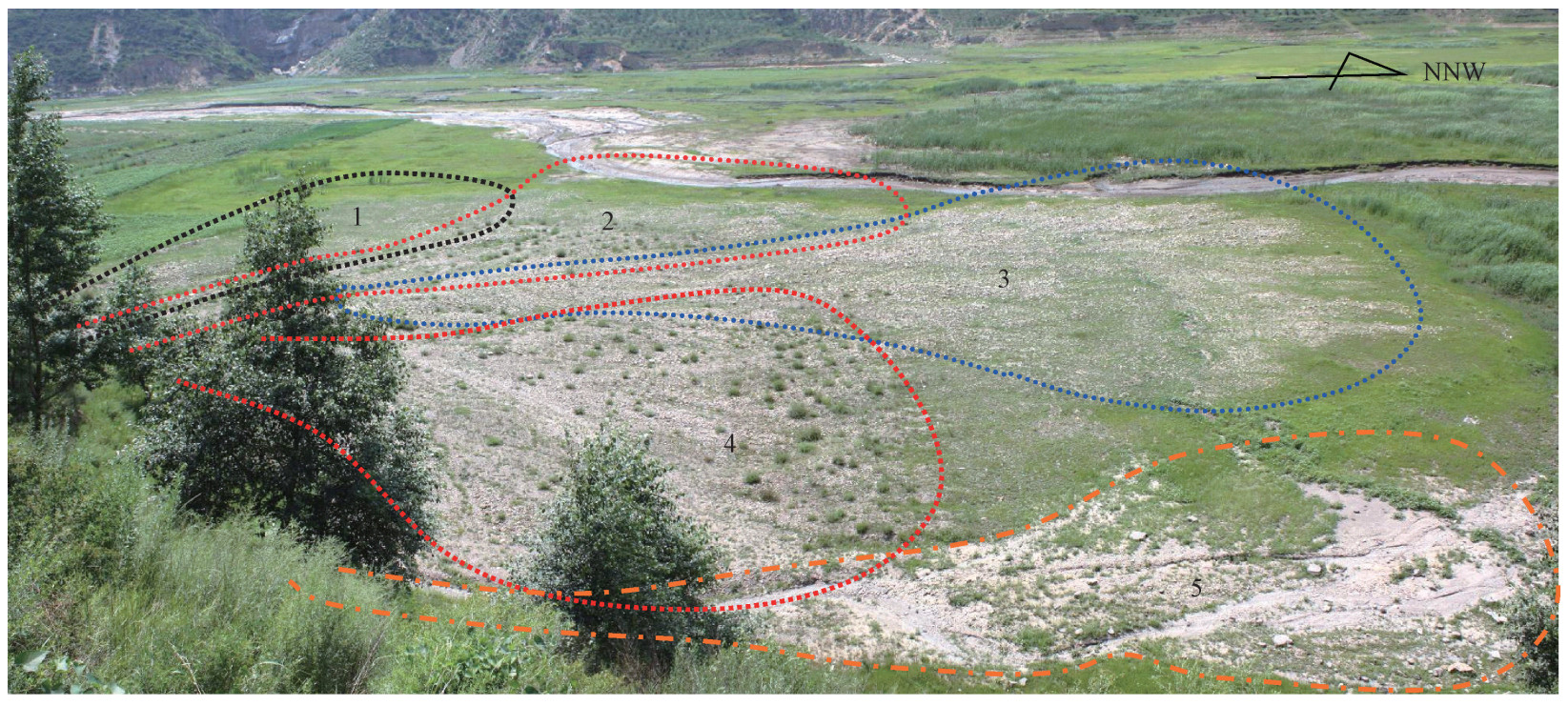
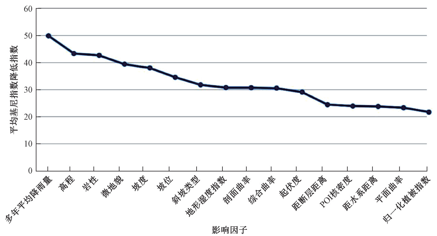
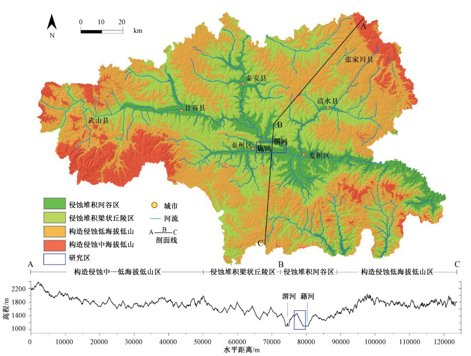
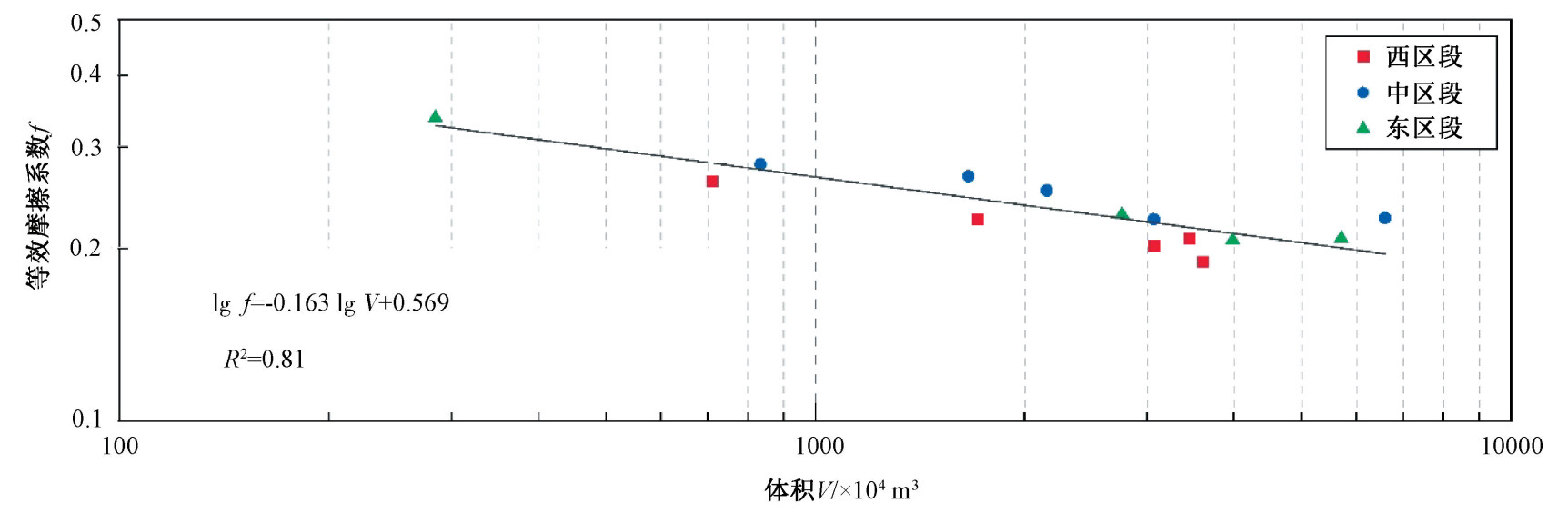
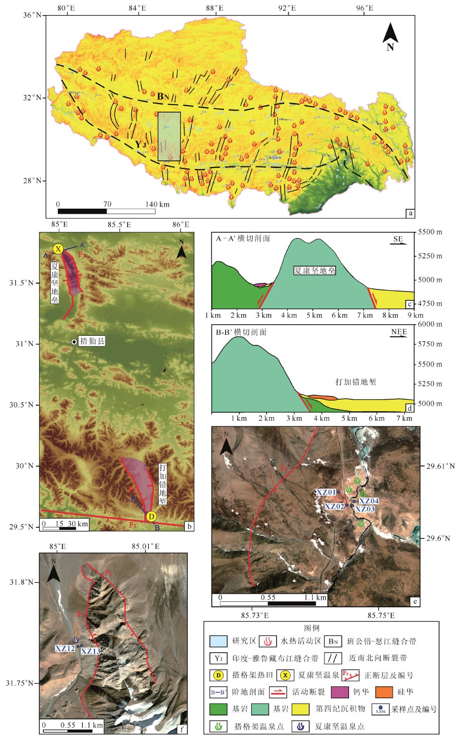
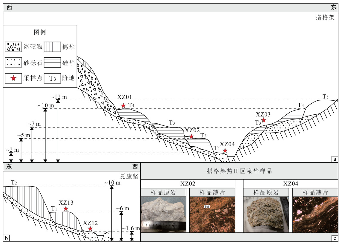
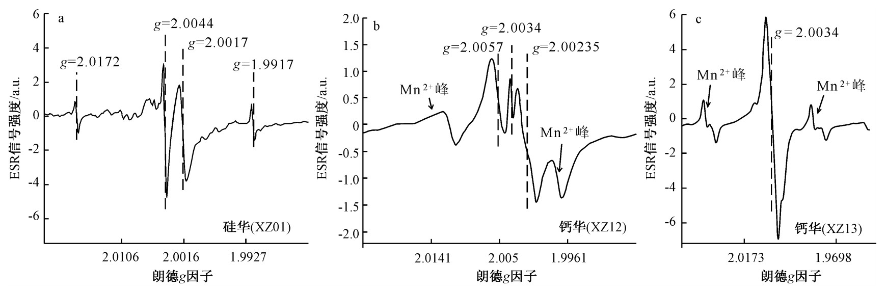
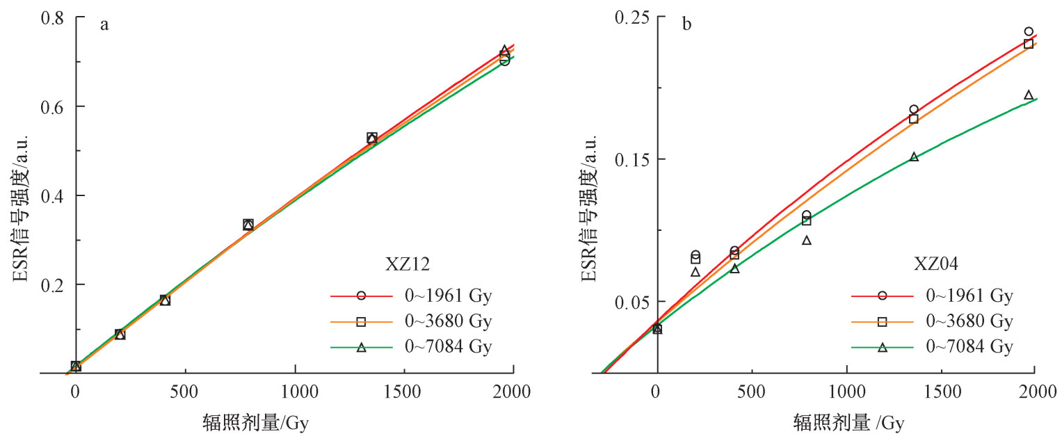
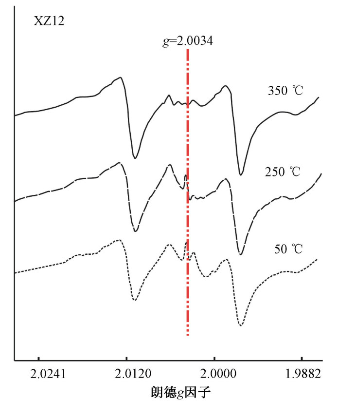
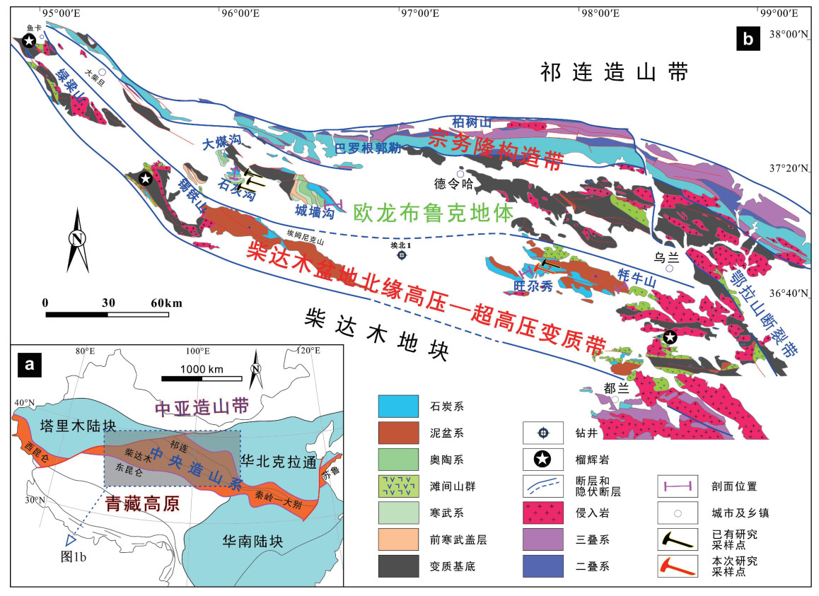
Sinters in the rift valleys of southern Tibet, including silica sinter and travertine deposits, are the products of hydrothermal activity under regional tectonic movement. Their formation age is significant for studying hydrothermal activity history in this region. Electron spin resonance (ESR) dating is a practical dating method for determining the age of silica sinter and travertine deposits. However, silica sinter's ESR signals vary due to the complex composition. Meanwhile, these ESR signals are mixed, superimposed, and interfere with each other, affecting the ESR signal's measurement. Furthermore, ESR dating has been applied less in travertine samples in southern Tibet, which is not conducive to a comprehensive understanding of the hydrothermal activity history in southern Tibet. Studying the applicability of ESR dating of southern Tibetan silica sinter and travertine deposits helps obtain accurate ESR ages. It lays the chronologic foundation for researching tectonic activities in these rift valleys. This research applied ESR dating to the silica sinter and travertine deposits collected separately from the Targejia thermal field area and the Xiakangjian hot spring area, located in the Ngri-Xigaze area in southern Tibet. We performed ESR dating tests, including how to choose ESR signals, the effect of additional doses, and the thermal stability of ESR signals in travertine. Based on these tests, relatively accurate, reliable ESR ages of silica sinter and travertine were obtained. The results show that: According to the ESR dating results, the silica sinter samples collected from the fourth and third terrace of the Targejia geothermal field were formed at 177±20 and 81±16 ka, respectively, and the travertine deposits collected from the floodplain and first terrace of the Xiakangjian hot spring were formed at 106±32 ka and 264±26 ka, respectively. In terms of irradiation dose, sinter samples collected from southern Tibet respond well to irradiation dose in the range of 0~7680 Gy; In terms of temperature, silica sinter samples are less affected by closure temperature, and the thermal behavior of the ESR signal at g=2.0034 of travertine in southern Tibet is stable in the range of 20 ℃~250 ℃ that is suitable for ESR dating. Regarding mineral structure, The travertine in southern Tibet has better mineral purity and crystallinity; thus, the ESR age results are relatively accurate.

General Geology & Regional Geology
Discovery of Permian tuff from the northern margin of the Qaidam Basin and its geological implications
LIU Jia, QIAN Tao
2023, 29(2): 290-300. doi: 10.12090/j.issn.1006-6616.2023002
Abstract (485) HTML (108) PDF (28264KB)(79)
Abstract:

Whether the Permian sedimentary records are still preserved in the northern Qaidam Basin is an open issue with various viewpoints. Most regional geological correlations imply that those Permian successions have been wholly eroded or that there is no Permian deposition in this area. These arguments were partly derived from the contrasting interpretations of the age of the fossils obtained from the Zhabusagaxiu formation. Other scholars consider that the lower unit of the Zhabusagaxiu formation, composed of alternating sandstone, mudstone, and limestone, belongs to the Carboniferous. In contrast, its upper limestone member should be assigned an early Permian sedimentary age, hinting that Permian successions are preserved in the northern Qaidam Basin. Therefore, it is still unclear whether the Permian sedimentary records are still preserved in the northern Qaidam Basin. In this study, the Keluke and Zhabusagaxiu formations in the Wanggaxiu-Dongdagou section were investigated in the field and measured in detail, and several volcanic tuff interbeddings were identified. Zircon LA-ICP-MS U-Pb geochronological studies were undertaken on zircons retrieved from a collected tuff sample. A high-precision weighted mean age of 295±2 Ma(MSWD=0.035)was obtained for the first time. This firstly reported age estimate solidly constrains the existence of the Permian strata in the northern Qaidam Basin. This clue will provide new insight into the following oil-gas exploration concerning the Permian successions and also provide a crucial limit on the studies of Carboniferous-Permian global climate change and sea level change.