2023 Vol. 29, No. 3

Cover
Cover Page
2023, 29(3)
Abstract (164) PDF (1311KB)(77)
Abstract:
Contents
Contents
2023, 29(3)
Abstract (271) HTML (141) PDF (430KB)(47)
Abstract:
Guest Chief Editor's Adress
2023, 29(3): 1-2.
Abstract (139) HTML (95) PDF (380KB)(30)
Abstract:
Crustal Stress Monitoring Technologies and Applicaiton
A brief talk on comprehensive crustal activity observation technology of deep-holes
CAI Meifeng
2023, 29(3): 301-312. doi: 10.12090/j.issn.1006-6616.20232901
Abstract (1068) HTML (83) PDF (2098KB)(79)
Abstract:

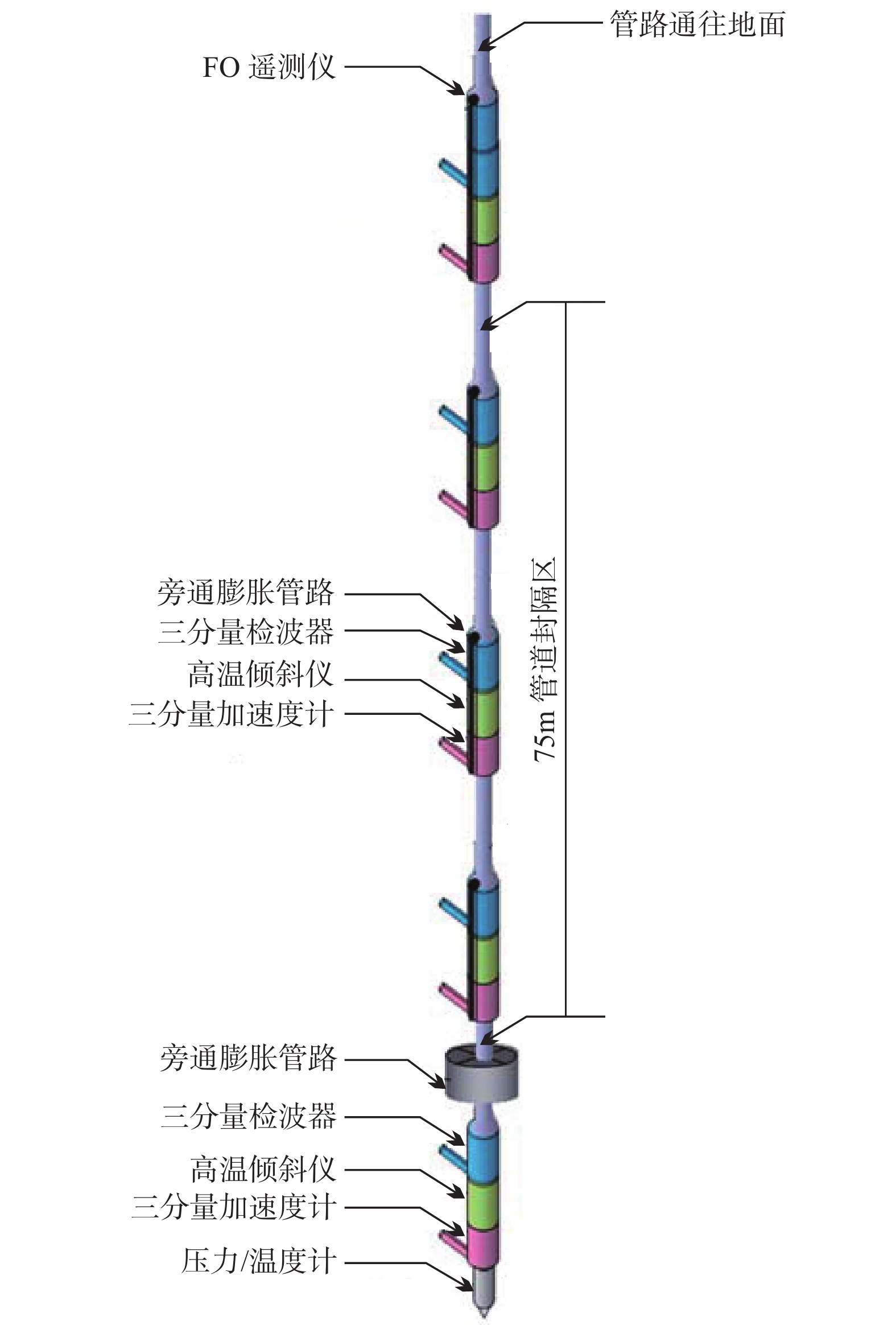
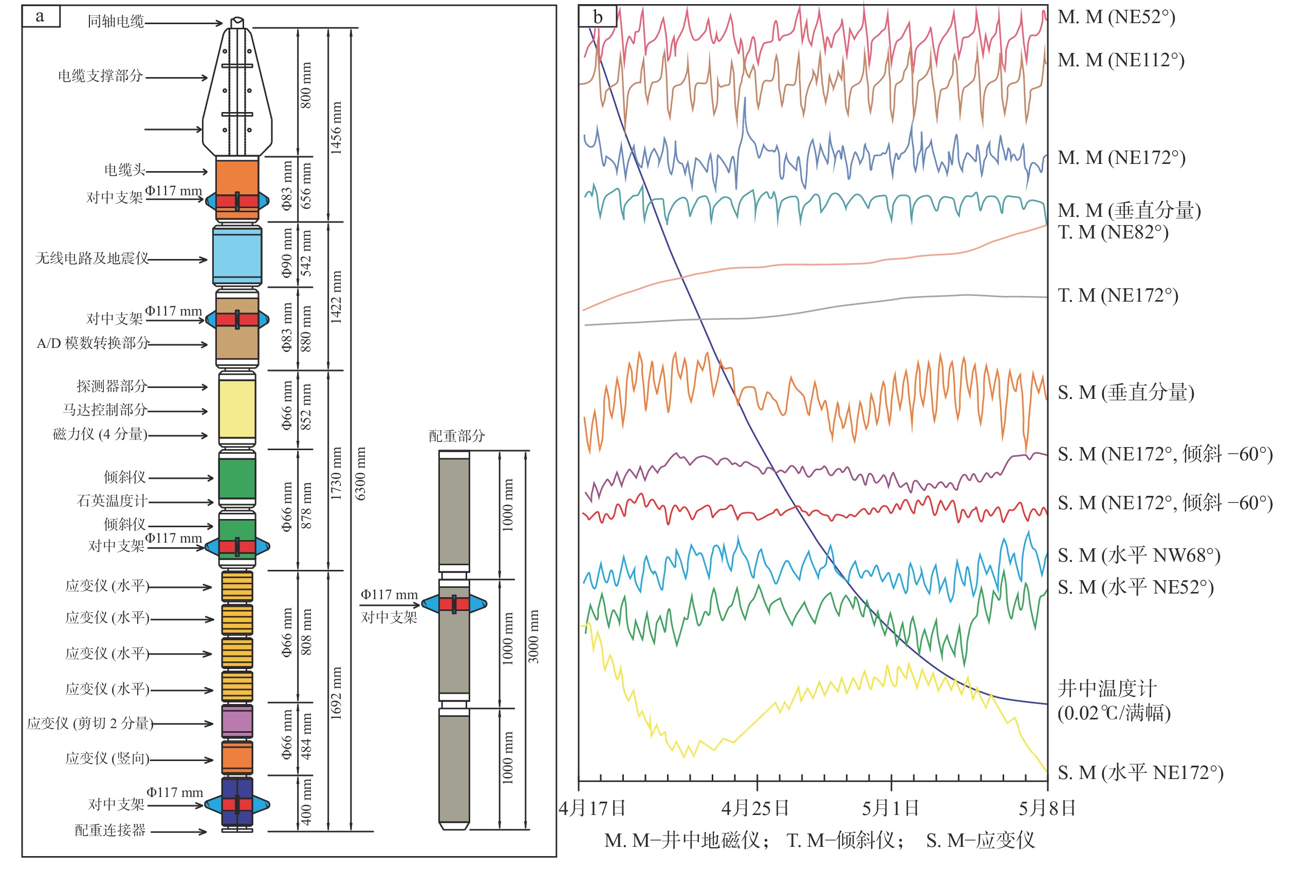
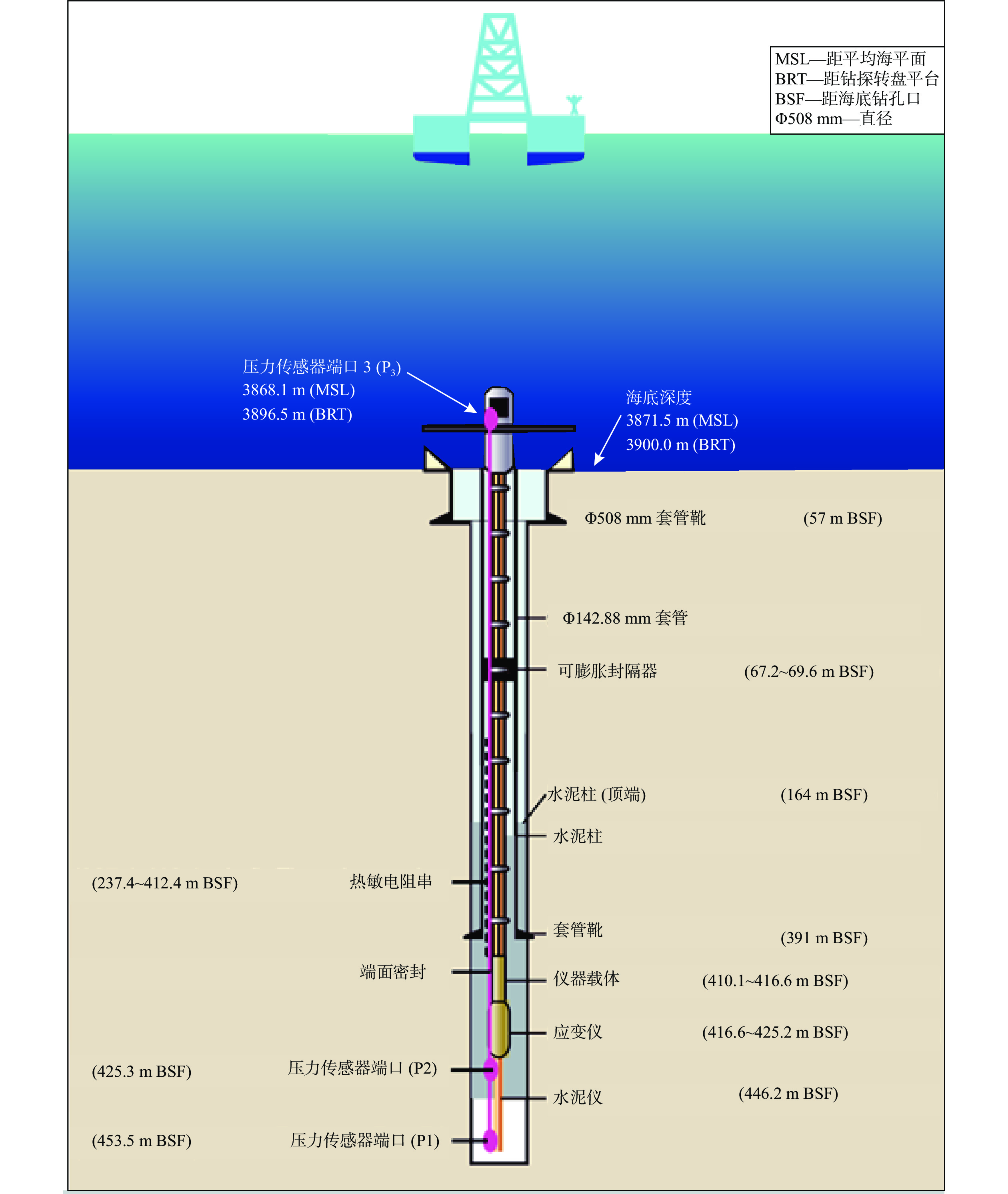
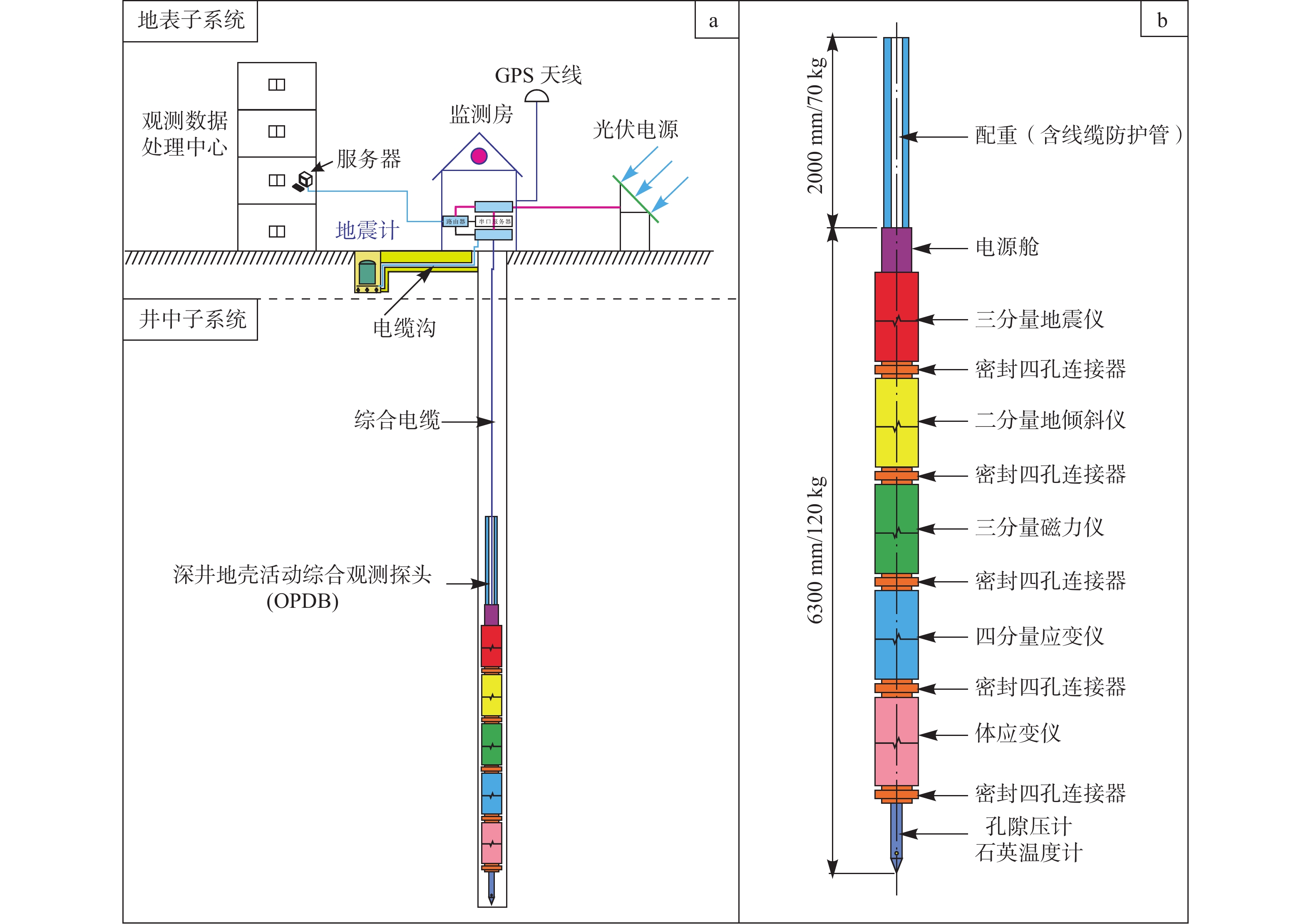
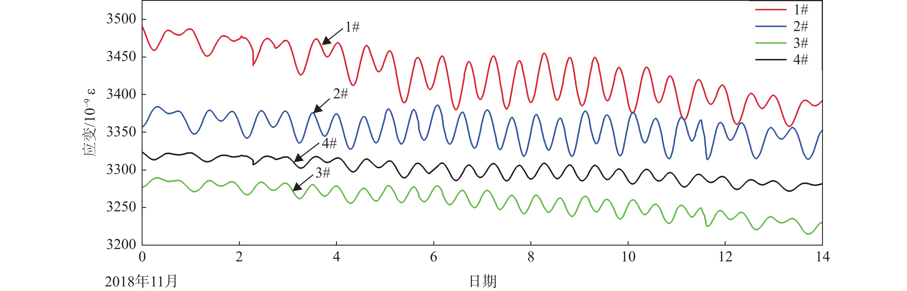
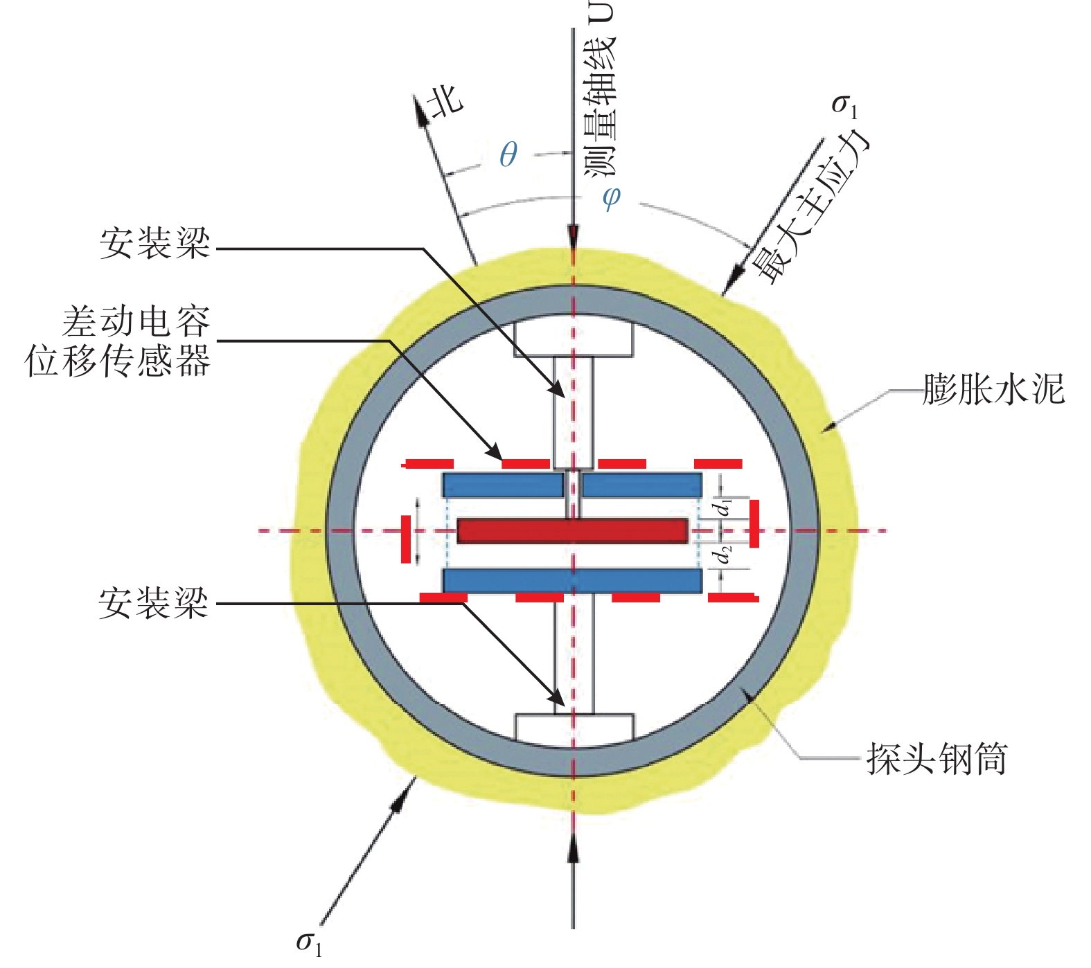
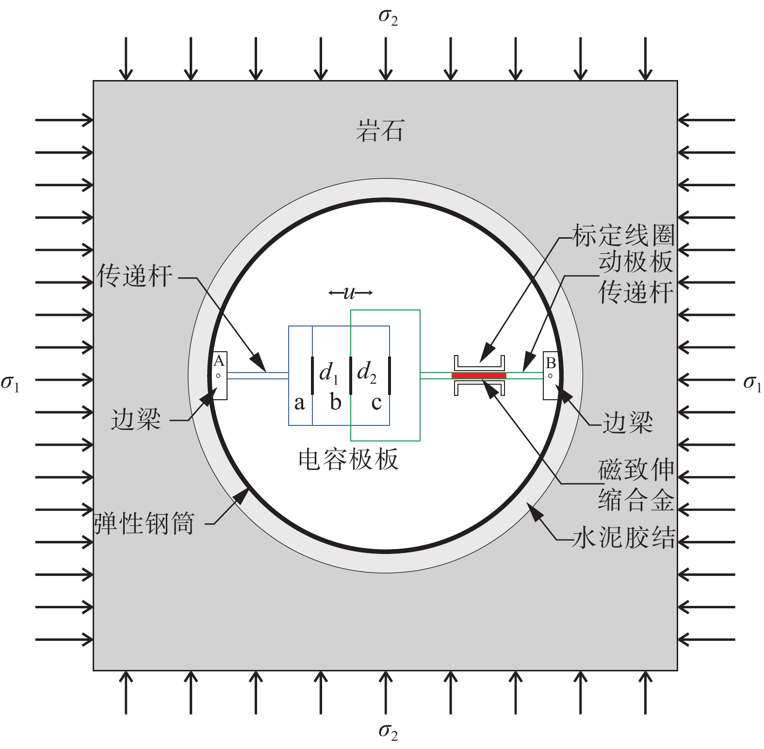
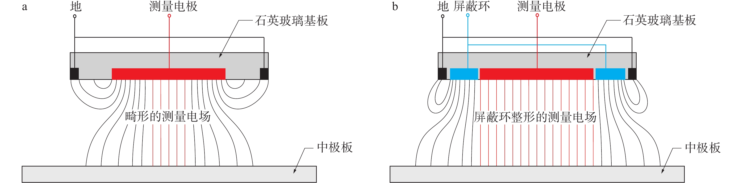
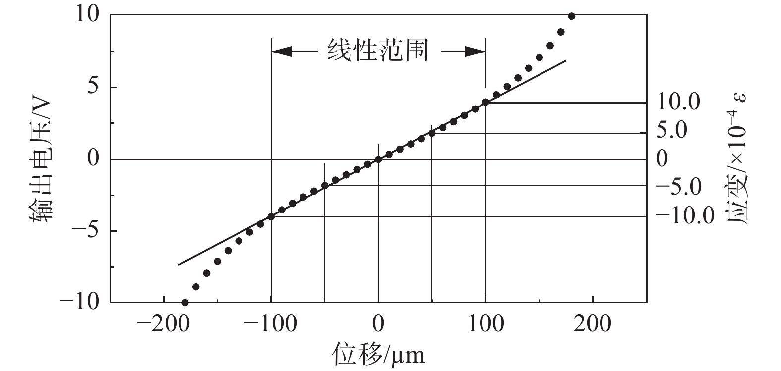
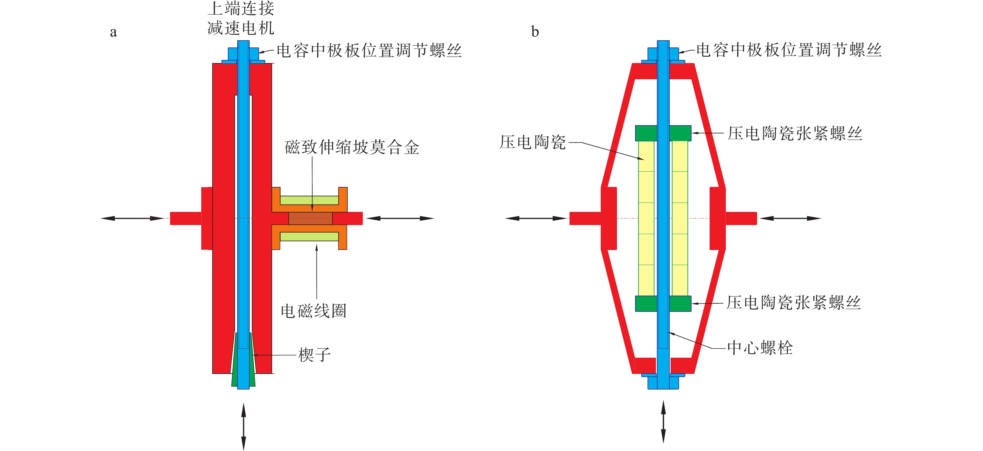
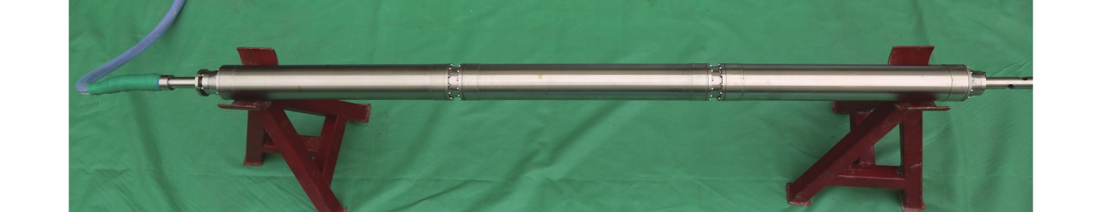
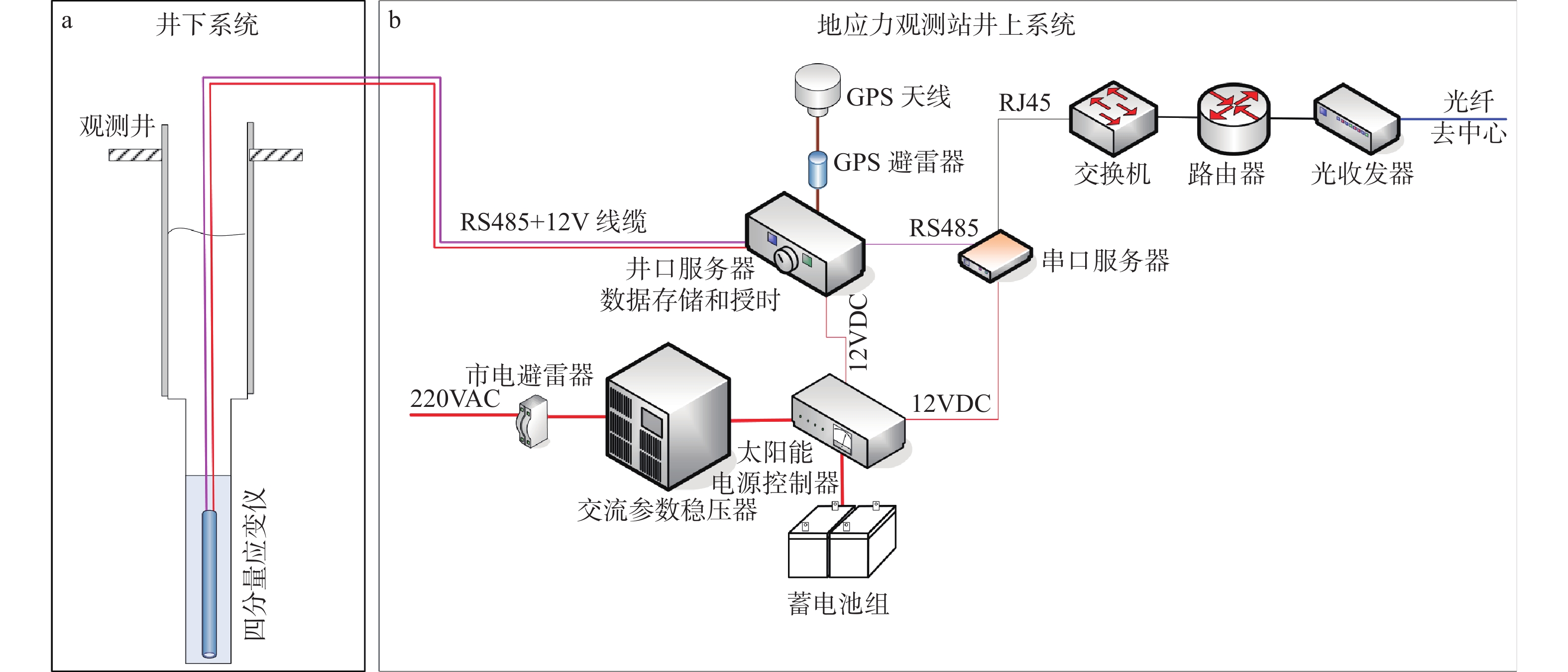
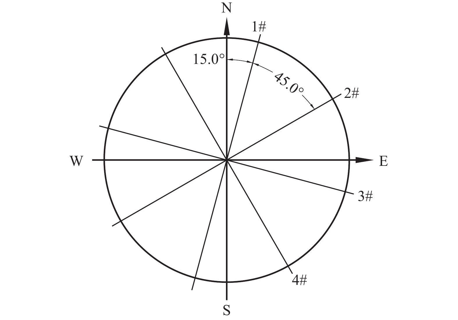
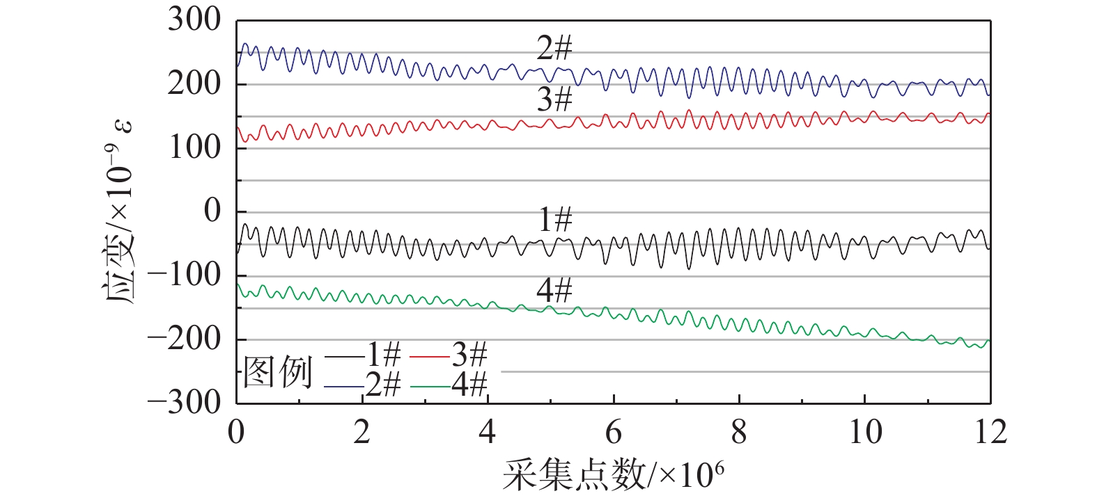
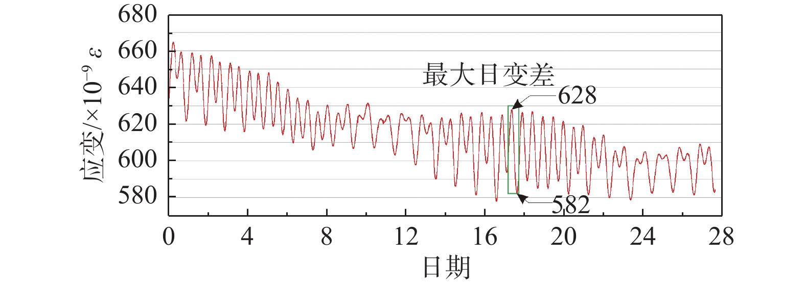
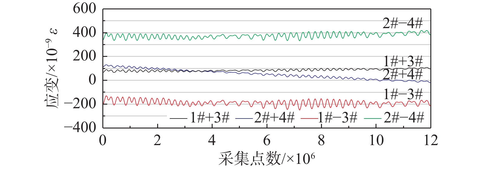
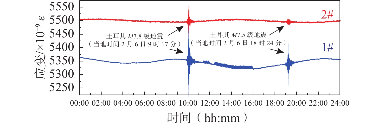
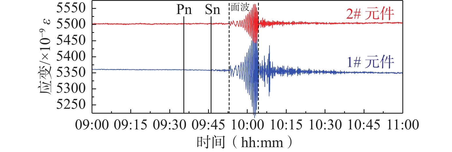
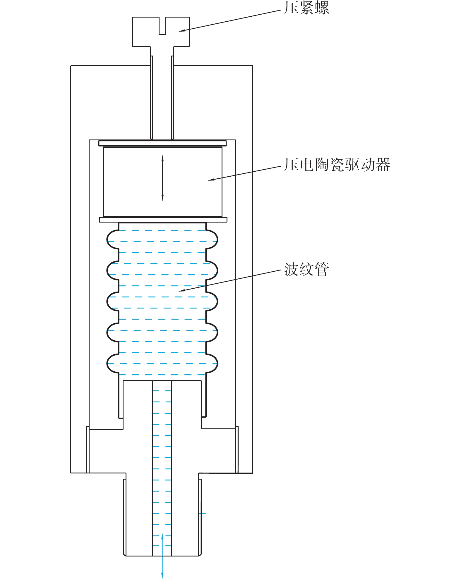
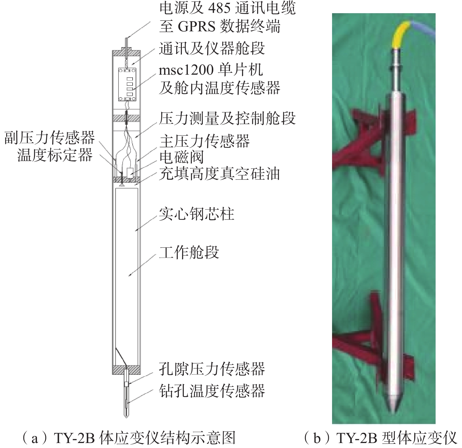
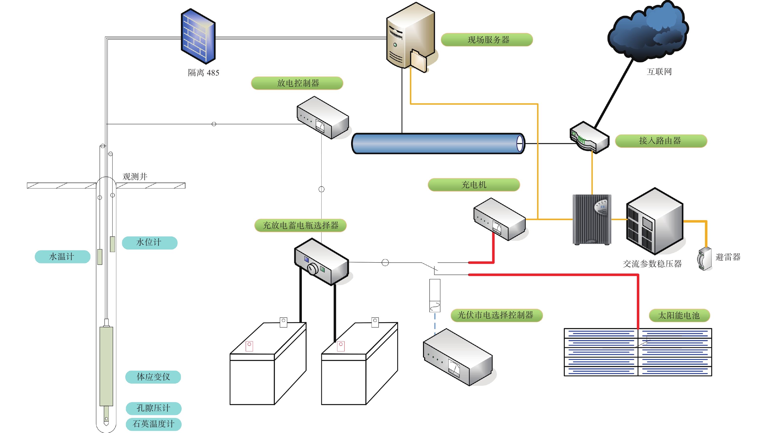
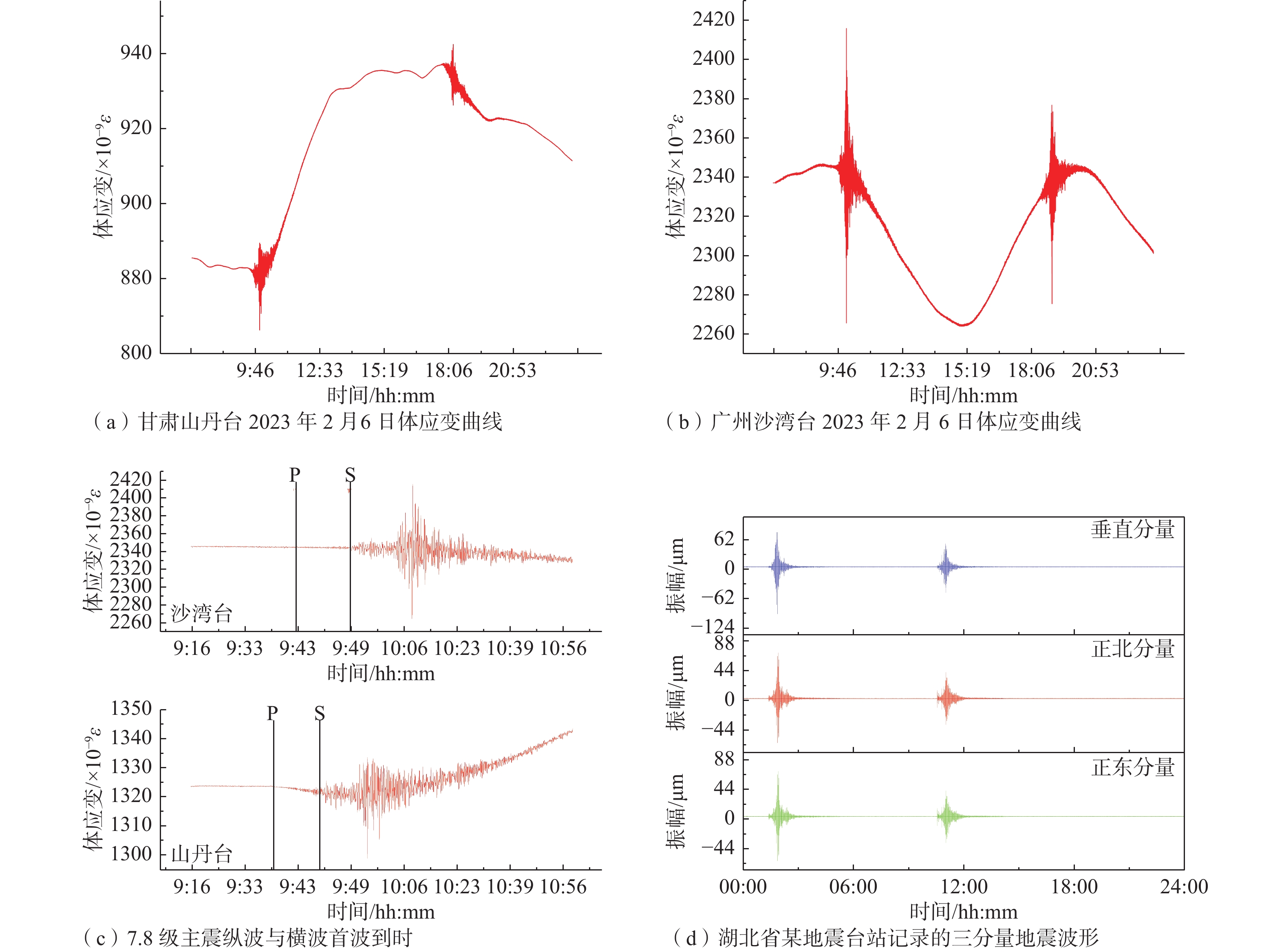
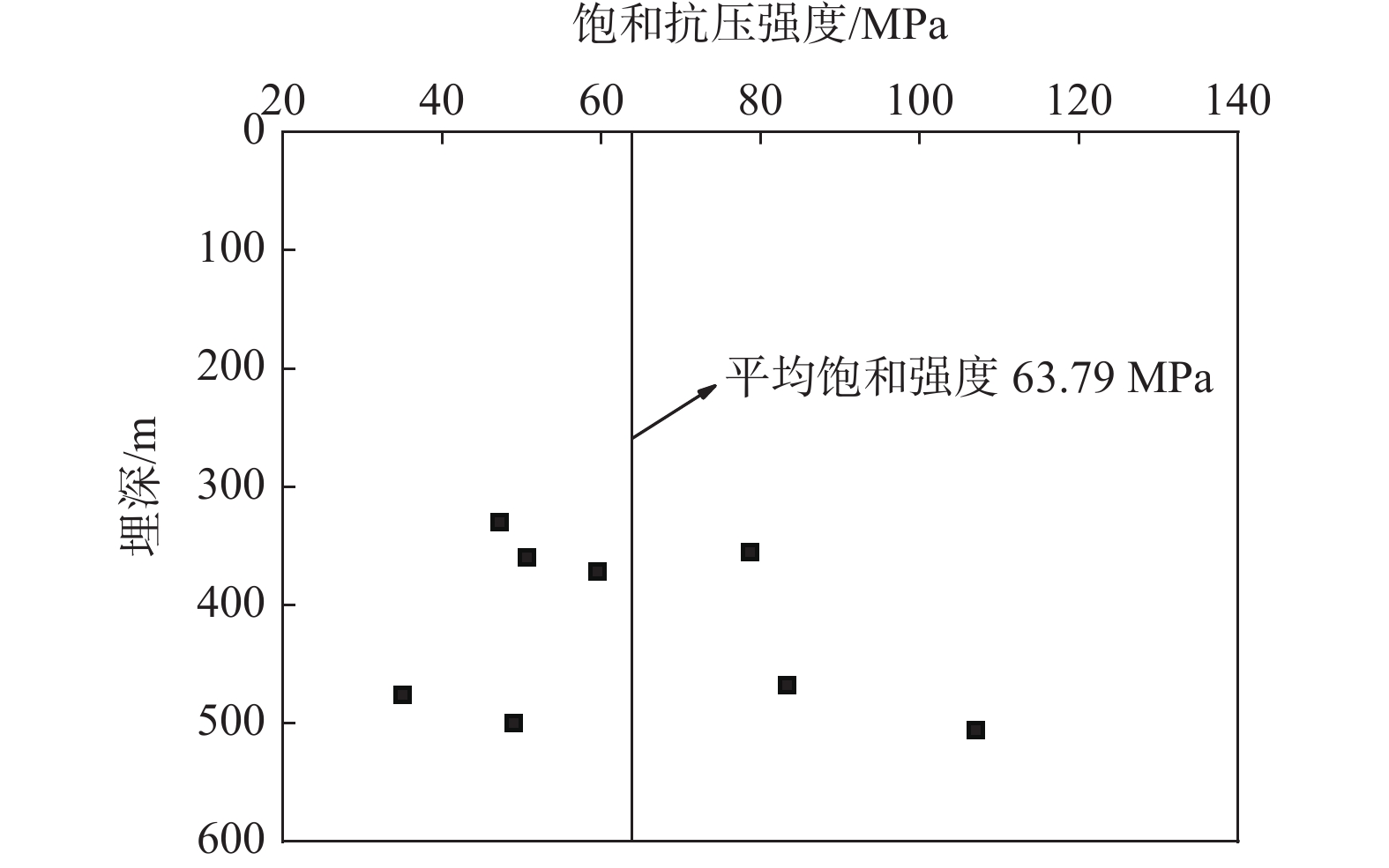
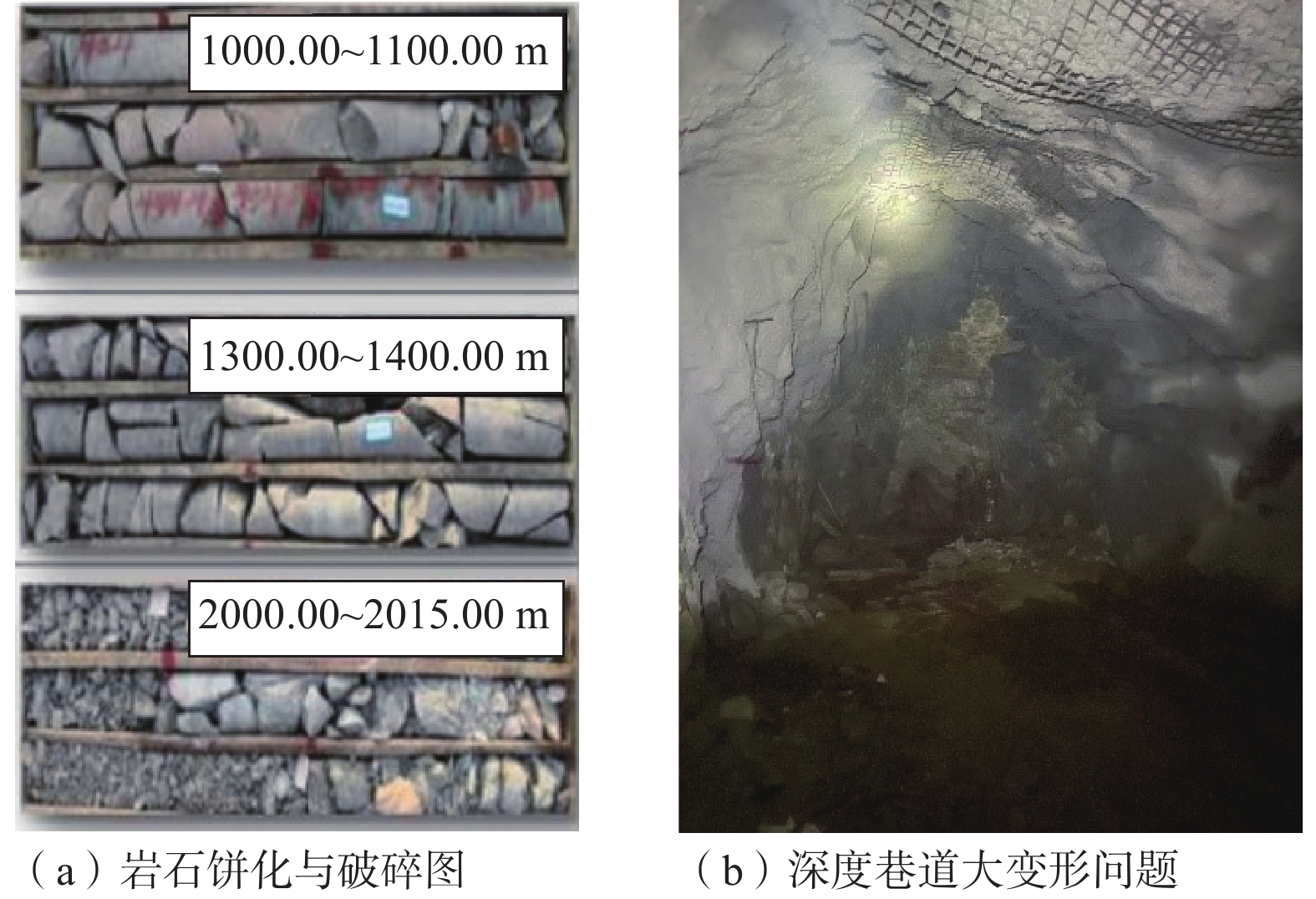
Under the action of the Earth’s inner dynamics, the lithosphere shapes different types of the Earth’s surface, and the crustal stress state and its dynamic change law are captured by the comprehensive observation technology of drilling crustal activity. It is an important way for human beings to understand the internal dynamic process of the Earth and study the mechanism of inner dynamic geological hazards. The contribution of developed countries such as Japan, the USA, and the IODP International Cooperative Research Program to the development of integrated borehole crustal observation technology is summarized in this paper. The paper also systematically reviews the development history and present situation of borehole strain observation technology and borehole strain observation instrument in China. Especially since the 13th Five-Year, under the background of the national strategy of deep-sea exploration, the China Geological Survey Bureau (CGS), the China Earthquake Administration, and other systems have successively carried out research and development of the integrated geophysics observation system in wells, and have been put into use in integrated land and sea observation stations. The Institute of Geomechanics has successfully developed an integrated geophysics observation system for crustal activity using the key techniques of system integration. The system has a variety of strain, tilt, seismic, geomagnetic, geothermal, pore pressure, other sensors, and 16 components capable of observing crustal deformation, stress, strain, tilt, earthquake, and their induced geodynamic changes in the lithosphere, such as geotemperature, hydrology, geoelectricity, geomagnetism, etc. It has been put into use in Shandan (installed depth 253 m) and Pingwu (WFSD-4, 1600 m) observatories in Gansu and Sichuan provinces and has achieved initial results. It is a milestone for our comprehensive crustal activity observation technology to break through the 3000-meter-deep well in the future. It can provide vital information for geodynamics research, safe exploitation of deep mineral and geothermal resources, and prediction of internal dynamic geological hazards. At the same time, based on the national strategy of deep-sea exploration in the 14th Five-year, the future development direction of integrated observation system of deep-well crustal activity is pointed out.

Key technology and application of DRY-1B capacitive component borehole strain gauge
PENG Hua, MA Xiumin, SUN Yao, JIANG Jingjie, HAO Fei
2023, 29(3): 313-323. doi: 10.12090/j.issn.1006-6616.20232902
Abstract (902) HTML (82) PDF (2714KB)(55)
Abstract:

This paper briefly describes the theoretical basis of the DRY-1B capacitive component drilling strain gauge (drilling strain gauge). It discusses critical technologies such as micro-displacement sensing, noise reduction, temperature control, performance testing, and calibration. The strain gauge achieved high resolution (≥5×10⁻¹¹ε), wideband (10–100 Hz optional), extensive dynamic range (≥1×10⁻³ε), 24-bit AD recording, low power consumption (< 3W), and other technical indicators. Its performance is better than the United States PBO and Japan borehole strain gauge of the same period, and it is an international leading long-term observation instrument for crustal movement, which can basically meet the observation requirements of creep movement with slow accumulation of long-term strain and seismic and volcanic activity with a rapid change of short-term strain. Since 2008, through the application of more than 20 geostress stations, the borehole strain gauge has recorded a large amount of strain information, such as crustal deformation, fault activity, co-seismic strain wave, strain step, and ore pressure activity. Based on the results of the self-consistency test of strain monitoring data of the geostress station in the Beichangshan Mountain and the analysis of seismic mapping capacity of the Turkey earthquake, it is found that the strain curves of the 1#+3# and 2#+4# capacitance sensors at the Beichangshan Mountain stress station are generally stable, and the correlation coefficient R2 is 0.95. The annual variation rate of the differential strain of 1#–3# and 2#–4# elements is 10−8 magnitude, which reflects that the shear stress is dominant in the Long Island area and the stress environment of seismic activity is relatively high. The strain gauge was used to observe the apparent co-seismic strain response of Turkey’s M 7.8 and M 7.5 earthquakes on February 6, 2023. In particular, it obtained the M 7.8 main seismic surface wave period of 50–60 s, presenting an out-facing wave anomaly. Theoretically, the strain wave generated by the M 0.74 earthquakes within 100 km can be distinguished, and the application demonstration effect has been achieved. The borehole strain gauge has good popularization value and application prospects in geodynamics research and internal dynamic geological disaster monitoring.

Development of TY-series high-precision volumetric strain gauge: Analysis and application of its seismic reflection capability
SUN Yao, PENG Hua, JIANG Jingjie, MA Xiumin, HAO Fei, ZHANG Bin
2023, 29(3): 324-338. doi: 10.12090/j.issn.1006-6616.20232903
Abstract (871) HTML (129) PDF (2760KB)(41)
Abstract:

The article reviews the development of the volumetric borehole strain gauge. In response to the current problems of insufficient stability and bandwidth and low calibration accuracy of the volumetric strain gauge, a TY-2B-type small volumetric borehole strain gauge was developed with innovative improvements in the hydraulic sensor, control circuit, and calibration method. The improved hydraulic sensor improves the accuracy and reduces the instrument’s volume; the improved control circuit increases the sampling rate, bandwidth, and the instrument’s stability; the innovative piezoelectric ceramic calibration technology raises the reliability of the monitoring data. The test results show that the improved TY-2B volumetric strain gauge has a low power consumption of less than 3 W, good long-term stability, high sensitivity with a resolution of 10-11 ε, and suitable high-frequency and low-frequency. It has a sampling rate of 100 Hz and can acquire complete seismic strain waveforms with precise and stable solid tide waveforms. It is small and light, with a reduced outer diameter of Φ89 mm for Φ100 mm drilling, a length of 1300 mm, and a weight of 45 kg for easy transport and installation. After 15 years of laboratory and field station testing, it obtained good monitoring data and demonstrated its highly sensitive seismic reflection capability. The observed response of the volumetric strain station in the northern section of Longmen Mountain to the 2010 Yushu earthquake and the 2023 Turkey earthquake shows that the TY-series high-precision volumetric strain gauge is not only a static strain gauge but also a broad-frequency strain seismograph with dynamic-static calibration capability. It has a unique advantage over pendulum seismometers in that it can observe both the long-term slow deformation and accumulation of deformation in the earth’s crust and the transient subtle features of crustal rupture and deformation. The long-term trends of the monitoring curves obtained from the Qingchuan–Hanzhong volumetric strain stations since the Wenchuan earthquake and the Guangzhou station since 2021 are consistent with the regional geological characteristics reflected by the seismic and tectonic geological data, indicating that the TY-2B volumetric strain gauge can meet the needs of geological scientific research and geological hazard observation.

Dynamic variation characteristics of in-situ stress in the 1605 Qiongshan M 7½ earthquake area and its implications to the Dongzhaigang subsidence, northeastern Hainan Island, China
JIA Liyun, MA Xiumin, JIANG jingjie, LEI Zhe, WEI Yongyi, MAO Jiarui, HAO Fei
2023, 29(3): 339-354. doi: 10.12090/j.issn.1006-6616.20232904
Abstract (1109) HTML (91) PDF (4084KB)(79)
Abstract:

Based on the strain data of three in-situ stress monitoring stations in different sections of the 1605 Qiongshan 7½ earthquake area, we studied the dynamic variations of in-situ stress and extracted the sudden stress changes recorded by them. We analyzed the in-situ stress variations and tectonic activity between March 2016 and May 2018 to discuss the geomorphological evolution trends and subsidence mechanisms at the Dongzhai Port. The results show that the study area was generally subjected to the NW-compressive stress field, which makes the tensile stress field dominate in the Yanfeng and Dazhipo areas in the hanging wall of the Maniao-Puqian fault(MPF) and the Puqian-qinglan fault(PQF), while the Jinshan area in the footwall of the faults by compressive stress. The MPF fault and the PQF fault have been constantly engaged in non-seismic activities to adjust the local stress field under the regional stress field, among which the MPF Fault had several activities in March–July 2016, October 2017, and April 2018, and the PQF fault had two activities in October 2017. The energy of the MPF activities is more intensive than that of the PQF. The variation trend of the stress field indicates a gradual upward trend in the east bounded by the MPF fault (F13-1) and possible continued subsidence in Dongzhaigang in the west. The fault activity trend implies that the subsidence rate in  Yanfeng, the northern part of Dongzhaigang, bounded by the MPF fault (F2-2), should be greater than that in the southern Sanjiang area. In addition, the volume strain monitoring data also reveals traces of magmatic activity in the lower part of the N–S seismic zone of Hainan Island. The comprehensive study concluded that the Dongzhaigang subsidence is mainly controlled by the positive fault activity of the MPF and PQF faults due to the upwelling of deep magma and influenced by the Holocene sea level change and the properties of soft soil depositional strata leading to soft soil flow slip, sand liquefaction, and seawater erosion. We innovatively apply the borehole strain observation technology to explore the evolution law and trend of typical earthquake subsidence landforms in coastal zones, which has essential academic value in the fields of in-situ stress monitoring and tectonic geomorphology research, and the results also have significant application value for mangrove protection and urban planning and construction in Dongzhaigang area.

Regional stress effect monitoring and precursory characteristics of dynamic disasters in deep coal mining
WU Haoyuan, ZHAO Yanbing, YANG Yong, XIA Lei, SUN Yuanyuan
2023, 29(3): 355-364. doi: 10.12090/j.issn.1006-6616.20232905
Abstract (920) HTML (135) PDF (1895KB)(45)
Abstract:

Dynamic disaster formation and triggering are closely related to the mechanical behavior of the regional stress field. The regional local stress field is continuously adjusted and changed under the effect of coal mining disturbance. In order to study the precursor response of regional stress field change to dynamic disasters, we used the analytical methods of variational modal decomposition and Hilbert transform to perform time-frequency analysis on the data collected from the Baodian coal mine and to identify and extract the intrinsic modal function (IMF) components reflecting the abnormal dynamic changes in the borehole strain data. The results show that the borehole strain observation data can effectively record the small changes inside the rock mass related to the mining disturbance. After decomposition and transformation, the abnormal fluctuation characteristics of IMF components appear two days before the dynamic pressure event, which is characterized by a “sudden jump” from the stage of stable deformation to the stage of rapid change, “shock” in the stage of rapid deformation change and “drop” in the stage of instability. According to the three-stage theory of seismic deformation, the normal starting time of deformation before the occurrence of dynamic disasters and the “sudden jump-shock-fall” are used as the precursor criteria for the occurrence of coal mine dynamic disasters. Based on the accurate observation of the regional stress field by borehole strainmeter, a criterion method applied to the warning of coal mine power hazards is constructed, which can provide a reference for the safe and efficient recovery of working faces under similar mining environments in coal mines.

Crustal Stress Measurement Technologies and Applicaiton
Influence of rock inhomogeneity degree on the crustal stress results measured by hydraulic fracturing method
CHEN Dongsheng, JI Hongguang, YUAN Yongzhong, LI Qintao
2023, 29(3): 365-374. doi: 10.12090/j.issn.1006-6616.20232906
Abstract (365) HTML (88) PDF (1541KB)(60)
Abstract:
Accurate in-situ crustal stress data are essential for excavation support design and long-term stability analysis of underground projects. We tested the main shaft of the Shaling Gold Mine for crustal stress using hydraulic fracturing technology, and the crustal stress state of 20 measurement points was obtained. The Brazilian test, uniaxial compression test, and acoustic emission test of the cores were conducted indoors to obtain the rock’s spatial inhomogeneity and strength distribution. We analyzed the relationship between the inhomogeneity of the rock and the hydraulic fracturing results. The analysis results show that the magnitude of the principal stress increases nearly linearly with the measurement depth, with the maximum horizontal principal stress value ranging from 20.78 to 45.2 MPa and the minimum principal stress value from 14.94 to 35.33 MPa. The average direction of the maximum horizontal principal stress is NW 65°. The inhomogeneity of each layer of the cores varies, and the inhomogeneity coefficient of the metagabbro is from 0.1 to 0.3. The number of acoustic emission signals under each intensity of the rock is basically the same, and the dispersion of the rock is small. The non-homogeneity coefficient of granite is up to 1.0, dominated by the acoustic emission signals generated by the intense-phase rupture at the late loading stage. The non-homogeneity of the rock affects the direction of expansion of the hydraulic fracture, and the angle $\varphi $ between the expansion direction and the maximum horizontal principal stress affects the measurement results of the horizontal maximum and minimum principal stresses and has a more significant effect on the horizontal minimum principal stress. The relationship between hydraulic fracture measurements and rock properties was analyzed, which is helpful for accurately detecting the distribution of stress fields in inhomogeneous strata.
In-situ stress state in critical areas of the Taiyuan pumped storage power station and its application in pivot project layout
BAI Jinpeng, DONG Yan’an, GAN Jun, ZHAO Xiaoyang, LI Hongli, CHAI Bao
2023, 29(3): 375-387. doi: 10.12090/j.issn.1006-6616.20232907
Abstract (336) HTML (61) PDF (2430KB)(36)
Abstract:

The hydraulic fracturing in-situ stress testing technology was used to test two boreholes (500-meter and 520-meter deep) at the Taiyuan pumped storage power station in Shanxi Province. The in-situ stress state of critical areas was obtained, and the ground stress level, underground building layout, and lining form in the project area were analyzed. The results show that the maximum horizontal principal stress ranges from 10.98 to 18.09 MPa, the minimum horizontal principal stress from 6.79 to 11.32 MPa, and the vertical principal stress from 9.61 to 13.57 MPa. Compared with the high and low in-situ stress values at the north and south ends of Shanxi Province, respectively, the measured values are between; Compared with the simulated in-situ stress field in the Qinshui Basin, the test results are basically consistent. The vertical stress values are between the maximum horizontal principal stress values and the minimum horizontal principal stress values (SH>Sv>Sh), which means the maximum horizontal stress at the measuring point is the maximum principal stress and is in the strike-slip stress state. Its lateral pressure coefficient Kav is between 0.92 and 1.09, reflecting that the tectonic action in the engineering area is not intense. In the range of 330–506 meters, the saturated uniaxial compressive strength of the two boreholes is betwwen 35 and 107 MPa, with an average of 63.79 MPa, and the ratio of the saturated strength to the maximum principal stress (

\begin{document}$ {{R}_{\mathrm{b}}} $\end{document}

/σm) is between 3.54 and 5.81, belonging to the medium–high stress level. The direction of the maximum horizontal principal stress in the project area is NE 43° to NE 70.5°, and the average is NE 59.5°, consistent with the regional focal mechanism solution and GPS displacement data. From the perspective of in-situ stress orientation, the average direction of the maximum principal stress in the engineering area is NE 59.5°, and the direction of the long axis of the underground powerhouse is between NE 29.5° and NE 89.5°, which is conducive to the stability of the surrounding rock of the powerhouse. The maximum water head PH of the underground hub project is about 4.62 MPa (i.e., PH <σ3). Based on the hydraulic splitting criterion, it can be seen that the rock mass can resist the maximum internal water pressure, and the reinforced concrete lining of the water transmission tunnel can satisfy the stability of the water transmission tunnel. The research results can be widely used in investigating and designing pumped storage power station projects.

Analysis of in-situ stress field characteristics and tectonic stability in the Motuo key area of the eastern Himalayan syntaxis
ZHANG Bin, SUN Yao, MA Xiumin, PENG Hua, JIANG Jingjie, MAO Jiarui, ZHANG Wenhui, ZHAI Yudong
2023, 29(3): 388-401. doi: 10.12090/j.issn.1006-6616.20232908
Abstract (491) HTML (129) PDF (7738KB)(120)
Abstract:

In order to obtain the in-situ stress field characteristics and analyze tectonic stability in the Motuo key area of the eastern Himalayan syntaxis, the in-situ stress measurement of one in-situ stress hole and 11 test sections of the Xirang section of the Motuo fault zone were carried out by the hydraulic fracturing method. The results show that the maximum and minimum horizontal principal stress values (SH, Sh) in the test section of 61.43−121.34 m are 3.05−14.50 MPa and 2.16−9.87 MPa, respectively, and the vertical principal stress values (Sv) are 1.63−3.31 MPa, namely, SH>Sh>Sv. The in-situ stress field at the measuring point is dominated by horizontal compression, and all of them belong to the in-situ stress state of reverse fault. The principal stress values gradually increase with the increase of depth, and the dominant direction of the maximum principal stress is NEE. In the whole range of in-situ stress depth, the lateral pressure coefficients (Kav) are 1.39−4.38, the maximum horizontal stress coefficients (KHv) are greater than 1, and the ratio increases with the increase of depth. The regional stress field of this key area is dominated by horizontal stress and it is highly directional. The horizontal stress coefficients (KHh) of all test sections are 1.23−1.66, which are similar to the calculation results of in-situ stress characteristic parameters in Linzhi−Tongmai section. The horizontal tectonic stress of the shallow level at 98 m is relatively small, and the stress accumulation level is low. The friction coefficient required to maintain fault stability is smaller than the critical friction coefficient of actual fault, and the tectonic environment is relatively stable. When the depth exceeds 98 m, the friction coefficient required to maintain fault stability is close to the critical friction coefficient value of the actual fault due to the dominant role of horizontal tectonic stress, and there is a small risk of fault instability slip. The superposition of the Coulomb stress change in the sinistral strike-slip direction and the thrust direction caused by the strong regional earthquakes on the fault plane of the Motuo fault zone in the study area are all negative numbers, which inhibits fault slip and does not increase the risk of fault activity in the study area.

Preliminary analysis of the influence of the activity in the Yalu River fault zone on the Wulongbei geothermal hot springs in Dandong under the action of crustal stress
MAO Jiarui, MA Xiumin, SUN Yao, JIANG Jingjie, ZHANG Wenhui
2023, 29(3): 402-416. doi: 10.12090/j.issn.1006-6616.20232909
Abstract (319) HTML (151) PDF (13925KB)(46)
Abstract:

The Yalu River fault zone is an essential branch of the Tanlu fault system with intense present-day tectonic activity. Over 60 hot springs are exposed along the fault zone with abundant geothermal resources. In order to find out the present-day crustal stress state and fault activity in the Wulongbei area of the southern section of the fault zone and to study the control and long-term influence of the fault activity on the geothermal water bodies of hot springs, in-situ stress measurements of 12 sections were carried out in the area by hydraulic fracturing method. The results showed that the maximum and minimum horizontal principal stresses (SH and Sh) range from 6.00 to 13.52 MPa and 3.18 to 7.26 MPa, respectively, in the depth range of 36.80–215.50 meters. In general, the three principal stresses showed an increasing trend with depth; in the middle section of the fracture zone (198.60–207.80 m), the three principal stress values meet the relation of SH>Sv>Sh, which is favorable to the strike-slip activity and has some potential for water-rich hydraulic conductivity, while the three principal stress values of the upper section (36.80–196.63 m) and lower section (215.50 m) accord with SH>Sh>Sv, which is favorable to the reverse fault activity, with poor longitudinal continuity of heat flow channels and poor hydraulic conductivity. Based on the present-day relationship between stress field characteristics and fault activity, it is deduced that the decline of the hot spring level in the Wulongbei area may be due to the fault activity under compressive stress, which gradually reduced the space of the hydraulic conductivity system by extrusion, causing the increase of discharge of runoff in other directions and the reduction of hot spring water supply. Based on the Coulomb frictional instability theory, the in-situ stress value in the depth range of 36.80–113.20 m in the fault zone reaches the lower limit of the critical stress value required for its activity. There is a possibility of dislocation in the future, and the fault activity may change the hot spring geothermal water supply channel. The research results have theoretical significance in studying the role of faults in controlling hot spring geothermal water and applying in-situ stress measurements near fault zones in geothermal research.

In-situ stress characteristics and rockburst tendency of surrounding rocks in the Shuiwangzhuang gold deposit, Zhaoyuan, Shandong province
LIU Luyong, LI Kaizhou, WANG Nengwei, YANG Zhijie, YANG Dongming, SUN Yao
2023, 29(3): 417-429. doi: 10.12090/j.issn.1006-6616.20232910
Abstract (316) HTML (79) PDF (1356KB)(52)
Abstract:

We carried out hydraulic fracturing in-situ stress measurements in an 1881-m deep borehole at the Shuiwangzhuang gold deposit and obtained the variation law of deep in-situ stress with depth in the mining area. The measurement results show that the maximum principal stress has an increasing linear trend with depth. The horizontal stress dominates the in-situ stress state within 800 m, and the vertical stress gradually transitions to the maximum principal stress with increasing depth. The maximum horizontal principal stress ranges from 11.22 to 45.69 MPa, the minimum horizontal principal stress from 7.28 to 36.17 MPa, and the vertical principal stress from 8.44 to 48.27 MPa; The direction of the maximum horizontal principal stress is NWW-trending. We analyzed the characteristics of the deep orebody’s in-situ stress according to the stress value and the direction of the maximum horizontal principal stress, which reveals that the deep in-situ stress of the Shuiwangzhuang mining area belongs to the generally low level in the Zhaoyuan–Laizhou area. We discussed the tendency of rockburst in the underground roadway during deep excavation under a high confining pressure environment based on rock mechanics parameters of drill cores, engineering rock grading standards, and elastic strain energy theory of rock bodies. The Shuiwangzhuang gold orebodies generally belong to the rockburst-free strata or strata with weak rockbursts. However, there is a strong rockburst tendency at depths such as 1102.78 m and 1379.40 m. The gold ore body is at a depth of 1680.40~1684.90 m, generally in the rockburst-free area. The above research results can provide an essential scientific basis for deep mine construction and mining design.

Numerical Simulation of Tectonic Stress Field
In-situ stress measurement and inversion analysis of the deep shaft project area in Sanshan Island based on hydraulic fracturing method
ZHU Mingde, WANG Zhaoya, ZHANG Yuezheng, LI Wenguang, HOU Kuikui, JI Hongguang, YIN Yantian, FU Zhen, HAO Yingjie
2023, 29(3): 430-441. doi: 10.12090/j.issn.1006-6616.20232911
Abstract (362) HTML (74) PDF (1700KB)(59)
Abstract:

The proposed 2000-meter-deep auxiliary shaft at the Xiling mine, Sanshan Island, Shandong Province, is an ultra-deep shaft construction project. Revealing the characteristics of the in-situ stress field in the shaft construction area is one of the necessary prerequisites for the design and construction of the shaft. We measured the in-situ stress in the deep shaft by hydraulic fracturing method to a depth of 1899.00 m and inverted the 2017.56-meter-deep in-situ stress field in the shaft construction area by numerical simulation. The results show that the maximum horizontal principal stress (SH) ranges from 23.16 to 70.86 MPa, and the minimum horizontal principal stress (Sh) from 15.24 to 47.06 MPa in the depth range from 357.76 to 1899.00 m in the borehole tested by hydraulic fracturing; the principal stress increases nearly linearly with depth, and the measured maximum horizontal principal stress directions in the measured boreholes are NW 55.5°, NW 60.4°, and NW 58.4°, respectively. Horizontal stress mainly dominates the stress field in the shaft engineering area, the vertical stress (Sv) below 1200.00 m is the intermediate stress, and the average value of the ratio of SH to Sv is 1.53. The in-situ stress field distribution pattern in the well-construction area with depth and stratigraphic changes is obtained by inversion analysis of FLAC 3D software. The inversion results are basically consistent with the measured values. It provides the fundamental scientific basis for shaft wall design and engineering risk assessment of shaft projects.

In-situ stress measurement and inversion analysis of a large hydropower project in southeast Tibet
LI Zhengzheng, YANG Wenchao, ZHANG Peng, LI Changhu, FAN Yulu
2023, 29(3): 442-452. doi: 10.12090/j.issn.1006-6616.20232912
Abstract (339) HTML (89) PDF (5215KB)(61)
Abstract:

As a control and regulating project, the hydropower station in the Yigongzangbu basin of Tibet plays a vital role in meeting the electricity demand of the Tibetan power grid. Identifying this hydropower station’s present-day in-situ stress environment and understanding the characteristics of in-situ stress distribution at critical locations such as underground plants and diversion tunnels are essential to ensure its engineering safety. Based on the tectonic and geological background and rock conditions of the project area, we carried out hydraulic fracturing in-situ stress measurements by placing boreholes and obtained in-situ stress data from 4 measurement points (8 boreholes). A finite element three-dimensional geological model was established according to the existing geological conditions. The measured stress state revealed the loading conditions, and the inverse analysis of the stress field in the engineering area was made. The maximum horizontal principal stress ranges from 4.17 to 16.93 MPa in the 2D test and 14.2 to 16.23 MPa in the 3D test. The maximum horizontal principal stress orientation is NE 38°to NE 47°, and the NE direction dominates the present-day tectonic stress field. In the 2995-meter elevation horizontal plane of the underground plant area of the power station, the stress values of σ1, σ2, and σ3 range from 11.70 to 12.12 MPa, 9.81 to 10.74 MPa, and  5.22 to 6.85 MPa, respectively. The maximum principal stress value of σ1, σ2, and σ3 along the diversion tunnel range from 11.8 to 14.05 MPa, 10.13 to 12.83 MPa, and  4.56 to 8.49 MPa, respectively. The axis direction of this hydropower station’s underground plant and the diversion tunnel’s axis direction intersect at a slight angle with the direction of the measured maximum principal stress, and the ground stress field is favorable to the stability of the project cavern. It is necessary to consider the actual geological conditions and adopt suitable tunnel construction technology in the later construction process. The construction monitoring should also be strengthened to ensure the project’s safe construction.

Inside Front Cover
Inside Front Cover
2023, 29(3): 453-453.
Abstract (135) PDF (1315KB)(29)
Abstract:
Inside Back Cover
Inside Back Cover
2023, 29(3): 454-454.
Abstract (133) PDF (1219KB)(30)
Abstract: