| Citation: | SUN Deliang,
CHEN Danlu,
MI Changlin,
et al.,
2023. Evaluation of landslide susceptibility in the gentle hill-valley areas based on the interpretable random forest-recursive feature elimination model. Journal of Geomechanics, 29 (2): 202-219. DOI: 10.12090/j.issn.1006-6616.2022128

|
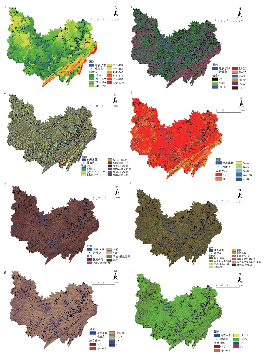
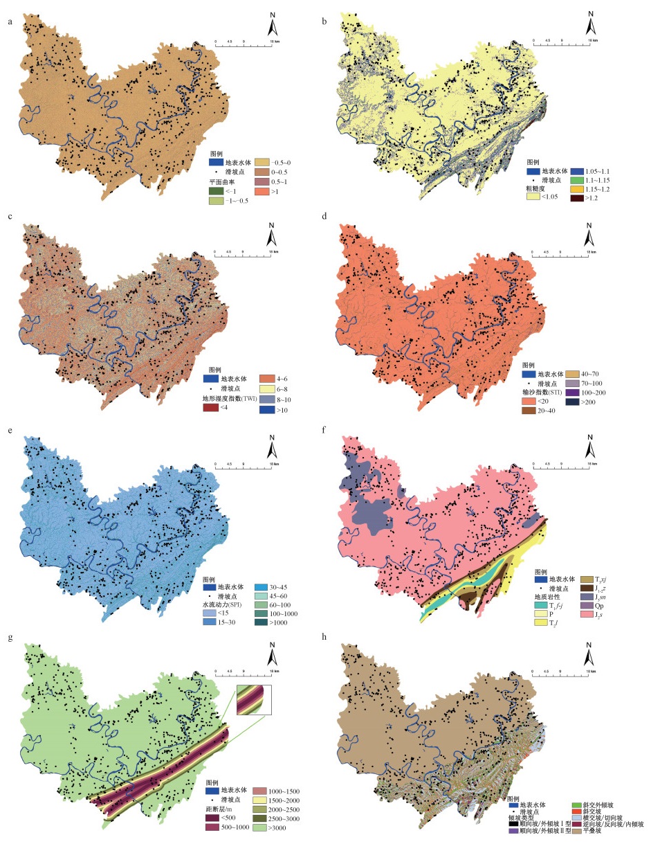
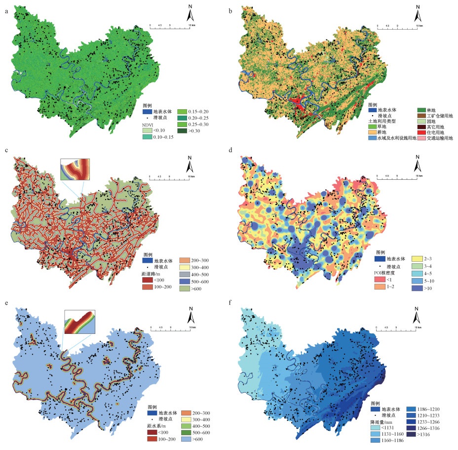
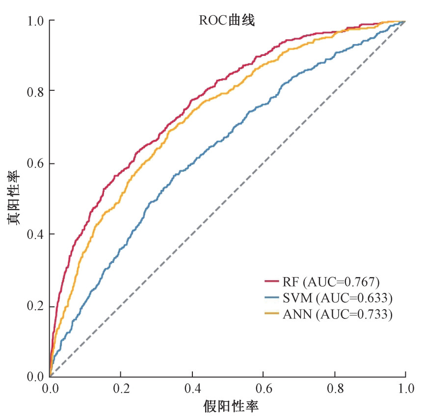
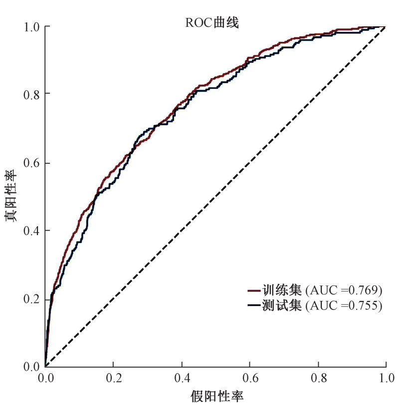
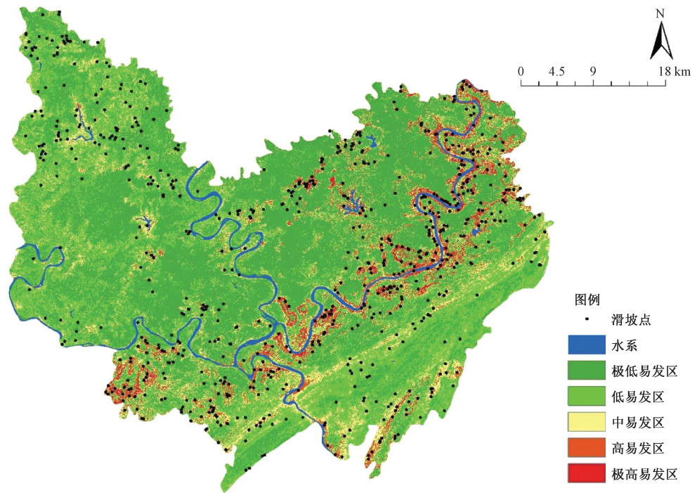
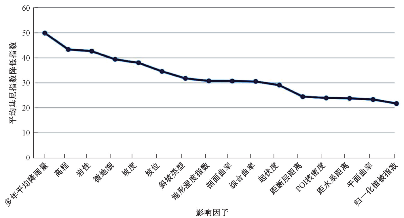
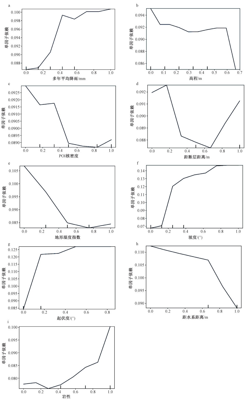
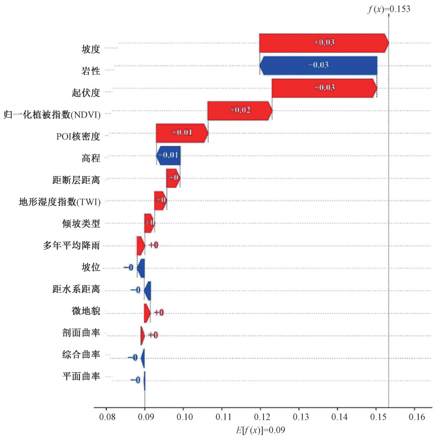
This study aims to evaluate landslide susceptibility and explain the internal mechanism of gentle hill-valley through SHAP partial interpretation and PDP partial dependency map based on the random forest-recursive feature elimination model to provide references for geological disaster prevention and control. We used the optimized random forest algorithm to analyze the landslide susceptibility of the specific hill-valley areas and established a landslide susceptibility evaluation model. The recursive feature elimination algorithm was used to eliminate noise factors. Sixteen factors of four types, including terrain, geology, environmental conditions, and human activities, were selected to build a landslide hazard factor database for the Hechuan district. Then we combined 754 historical landslide sites in the Hechuan district with the factor database to derive a landslide susceptibility zoning map for the study area, and the factor importance was ranked using the random forest algorithm. Finally, a partial dependency plot is applied to explain the factors strongly influencing landslide occurrence in the Hechuan district and the SHAP algorithm for a local explanation of individual landslides. The results show that: compared with the original model, the AUC value of the test set of the random forest-recursive feature elimination model has increased by 0.019, demonstrating the effectiveness of the recursive feature elimination algorithm. According to the evaluation results of the random forest model, the AUC values of the training set and the test set are 0.769 and 0.755, respectively, with high prediction accuracy. The density is high in areas with large undulations, and historical landslides are concentrated in high-susceptibility areas. The spatial distribution of landslides is uneven and complex, and the influence of each hazard factor on landslide occurrence has prominent regional characteristics and spatial heterogeneity. In hill-valley areas, the average annual rainfall, elevation, and lithology are the most critical factors affecting landslide occurrence. According to the local interpretation map of SHAP, the landslide on the uphill road of Baitaping is explained. The lithology and elevation played a role in restraining the landslide, and the undulation, slope, NDVI, and POI kernel density promoted the landslide. In summary, the random forest-recursive feature elimination model has high accuracy in landslide susceptibility evaluation in the hill-valley areas. The interpretation and analysis of the internal mechanism of the regional landslides and individual landslides through PDP and SHAP interpretation algorithms are conducive to constructing and improving the evaluation factor system for landslide susceptibility under different geomorphic environments. The internal decision-making mechanism of landslides is explored; it can provide a reference for the regional landslide susceptibility assessment and geological disaster prevention.

|
ACHOUR Y, BOUMEZBEUR A, HADJI R, et al., 2017. Landslide susceptibility mapping using analytic hierarchy process and information value methods along a highway road section in Constantine, Algeria[J]. Arabian Journal of Geosciences, 10(8): 194. doi: 10.1007/s12517-017-2980-6
|
|
BREIMAN L, 1996. Bagging predictors[J]. Machine Learning, 24(2): 123-140.
|
|
BRILL F, PASSUNI PINEDA S, ESPICHÁN CUYA B, et al., 2020. A data-mining approach towards damage modelling for El Niño events in Peru[J]. Geomatics, Natural Hazards and Risk, 11(1): 1966-1990. doi: 10.1080/19475705.2020.1818636
|
|
BUAH P A, ZHANG Y B, BAKAH D A Y, et al., 2019. Earthquake-induced landslide susceptibility analysis: The effect of DEM resolution[C]//2019 International Conference on Mechatronics, Remote Sensing, Information Systems and Industrial Information Technologies (ICMRSISIIT). Ghana: IEEE, 2019: 1-5.
|
|
CAN A, DAGDELENLER G, ERCANOGLU M, et al., 2019. Landslide susceptibility mapping at Ovacık-Karabük (Turkey) using different artificial neural network models: Comparison of training algorithms[J]. Bulletin of Engineering Geology and the Environment, 78: 89-102. doi: 10.1007/s10064-017-1034-3
|
|
CHEN W, POURGHASEMI H R, ZHAO Z, 2017. A GIS-based comparative study of Dempster-Shafer, logistic regression and artificial neural network models for landslide susceptibility mapping[J]. Geocarto International, 32(4): 367-385. doi: 10.1080/10106049.2016.1140824
|
|
CHEN W, PENG J B, HONG H Y, et al., 2018. Landslide susceptibility modelling using GIS-based machine learning techniques for Chongren County, Jiangxi Province, China[J]. Science of the Total Environment, 626: 1121-1135. doi: 10.1016/j.scitotenv.2018.01.124
|
|
CHEN W, CHEN X, PENG J B, et al., 2021. Landslide susceptibility modeling based on ANFIS with teaching-learning-based optimization and Satin bowerbird optimizer[J]. Geoscience Frontiers, 12(1): 93-107. doi: 10.1016/j.gsf.2020.07.012
|
|
CRAMER H, EVERS V, RAMLAL S, et al., 2008. The effects of transparency on trust in and acceptance of a content-based art recommender[J]. User Modeling and User-Adapted Interaction, 18(5): 455-496. doi: 10.1007/s11257-008-9051-3
|
|
DAS I, STEIN A, KERLE N, et al., 2012. Landslide susceptibility mapping along road corridors in the Indian Himalayas using Bayesian logistic regression models[J]. Geomorphology, 179: 116-125. doi: 10.1016/j.geomorph.2012.08.004
|
|
DAS J, KUMAR S, MISHRA D C, et al., 2023. Machine learning in the estimation of CRISPR-Cas9 cleavage sites for plant system[J]. Frontiers in Genetics, 13: 1085332. doi: 10.3389/fgene.2022.1085332
|
|
DIKSHIT A, PRADHAN B, ALAMRI A M, 2021. Pathways and challenges of the application of artificial intelligence to geohazards modelling[J]. Gondwana Research, 100: 290-301. doi: 10.1016/j.gr.2020.08.007
|
|
DOU J, YUNUS A P, TIEN BUI D, et al., 2019. Assessment of advanced random forest and decision tree algorithms for modeling rainfall-induced landslide susceptibility in the Izu-Oshima Volcanic Island, Japan[J]. Science of the Total Environment, 662: 332-346. doi: 10.1016/j.scitotenv.2019.01.221
|
|
EKMEKCIOǦLU Ö, KOC K, 2022. Explainable step-wise binary classification for the susceptibility assessment of geo-hydrological hazards[J]. CATENA, 216: 106379. doi: 10.1016/j.catena.2022.106379
|
|
FRIEDMAN J H, 2001. Greedy function approximation: A gradient boosting machine[J]. The Annals of Statistics, 29(5): 1189-1232. doi: 10.1214/aos/1013203450
|
|
HERLOCKER J L, KONSTAN J A, RIEDL J, 2000. Explaining collaborative filtering recommendations[C]//Proceedings of the 2000 ACM Conference on Computer Supported Cooperative Work. Philadelphia: Association for Computing Machinery: 241-250.
|
|
HONG H Y, SHAHABI H, SHIRZADI A, et al., 2019. Landslide susceptibility assessment at the Wuning area, China: A comparison between multi-criteria decision making, bivariate statistical and machine learning methods[J]. Natural Hazards, 96: 173-212. doi: 10.1007/s11069-018-3536-0
|
|
HUANG F M, YIN K L, HUANG J S, et al., 2017. Landslide susceptibility mapping based on self-organizing-map network and extreme learning machine[J]. Engineering Geology, 223: 11-22. doi: 10.1016/j.enggeo.2017.04.013
|
|
HUANG F M, CHEN J W, DU Z, et al., 2020. Landslide susceptibility prediction considering regional soil erosion based on machine-learning models[J]. ISPRS International Journal of Geo-Information, 9(6): 377. doi: 10.3390/ijgi9060377
|
|
KALANTAR B, PRADHAN B, NAGHIBI S A, et al., 2018. Assessment of the effects of training data selection on the landslide susceptibility mapping: A comparison between support vector machine (SVM), logistic regression (LR) and artificial neural networks (ANN)[J]. Geomatics, Natural Hazards and Risk, 9(1): 49-69. doi: 10.1080/19475705.2017.1407368
|
|
KAVZOGLU T, SAHIN E K, COLKESEN I, 2015. Selecting optimal conditioning factors in shallow translational landslide susceptibility mapping using genetic algorithm[J]. Engineering Geology, 192: 101-112. doi: 10.1016/j.enggeo.2015.04.004
|
|
KURADUSENGE M, KUMARAN S, ZENNARO M, 2020. Rainfall-induced landslide prediction using machine learning models: The case of Ngororero District, Rwanda[J]. International Journal of Environmental Research and Public Health, 17(11): 4147. doi: 10.3390/ijerph17114147
|
|
LIU C Z, WEN M S, TANG C, 2004. Meteorological early warning of geo-hazards in China based on raining forecast[J]. Geological Bulletin of China, 23(4): 303-309. (in Chinese with English abstract) doi: 10.3969/j.issn.1671-2552.2004.04.001
|
|
LIU R, SHI S X, SUN D L, et al., 2020. Based on GIS and random forest model for landslide susceptibility mapping in Wushan County[J]. Journal of Chongqing Normal University (Natural Science), 37(3): 86-96. (in Chinese with English abstract)
|
|
LUNDBERG S M, LEE S I, 2017. A unified approach to interpreting model predictions[C]//Proceedings of the 31st International Conference on Neural Information Processing Systems. Long Beach: Curran Associates Inc. : 4768-4777.
|
|
MARJANOVIĆ M, KOVAǦEVIĆ M, BAJAT B, et al., 2011. Landslide susceptibility assessment using SVM machine learning algorithm[J]. Engineering Geology, 123(3): 225-234. doi: 10.1016/j.enggeo.2011.09.006
|
|
MILNE F D, BROWN M J, KNAPPETT J A, et al., 2012. Centrifuge modelling of hillslope debris flow initiation[J]. CATENA, 92: 162-171. doi: 10.1016/j.catena.2011.12.001
|
|
MOAYEDI H, MEHRABI M, MOSALLANEZHAD M, et al., 2019. Modification of landslide susceptibility mapping using optimized PSO-ANN technique[J]. Engineering with Computers, 35(3): 967-984. doi: 10.1007/s00366-018-0644-0
|
|
MOOSAVI V, NIAZI Y, 2016. Development of hybrid wavelet packet-statistical models (WP-SM) for landslide susceptibility mapping[J]. Landslides, 13: 97-114. doi: 10.1007/s10346-014-0547-0
|
|
NAGHIBI S A, AHMADI K, DANESHI A, 2017. Application of support vector machine, random forest, and genetic algorithm optimized random forest models in groundwater potential mapping[J]. Water Resources Management, 31(9): 2761-2775. doi: 10.1007/s11269-017-1660-3
|
|
NGO P T T, PANAHI M, KHOSRAVI K, et al., 2021. Evaluation of deep learning algorithms for national scale landslide susceptibility mapping of Iran[J]. Geoscience Frontiers, 12(2): 505-519. doi: 10.1016/j.gsf.2020.06.013
|
|
PHAM B T, NGUYEN-THOI T, QI C C, et al., 2020. Coupling RBF neural network with ensemble learning techniques for landslide susceptibility mapping[J]. CATENA, 195: 104805. doi: 10.1016/j.catena.2020.104805
|
|
REICHENBACH P, ROSSI M, MALAMUD B D, et al., 2018. A review of statistically-based landslide susceptibility models[J]. Earth-Science Reviews, 180: 60-91. doi: 10.1016/j.earscirev.2018.03.001
|
|
SAHIN E K, COLKESEN I, KAVZOGLU T, 2020. A comparative assessment of canonical correlation forest, random forest, rotation forest and logistic regression methods for landslide susceptibility mapping[J]. Geocarto International, 35(4): 341-363. doi: 10.1080/10106049.2018.1516248
|
|
STUMPF A, KERLE N, 2011. Object-oriented mapping of landslides using random forests[J]. Remote Sensing of Environment, 115(10): 2564-2577. doi: 10.1016/j.rse.2011.05.013
|
|
SUN D L, 2019. Mapping landslide susceptibility based on machine learning and forecast warning of landslide induced by rainfall[D]. Shanghai: East China Normal University. (in Chinese with English abstract)
|
|
SUN D L, WEN H J, WANG D Z, et al., 2020a. A random forest model of landslide susceptibility mapping based on hyperparameter optimization using Bayes algorithm[J]. Geomorphology, 362: 107201. doi: 10.1016/j.geomorph.2020.107201
|
|
SUN D L, XU J H, WEN H J, et al., 2020b. An optimized random forest model and its generalization ability in landslide susceptibility mapping: Application in two areas of Three Gorges Reservoir, China[J]. Journal of Earth Science, 31(6): 1068-1086. doi: 10.1007/s12583-020-1072-9
|
|
SUN D L, SHI S X, WEN H J, et al., 2021a. A hybrid optimization method of factor screening predicated on GeoDetector and random forest for landslide susceptibility mapping[J]. Geomorphology, 379: 107623. doi: 10.1016/j.geomorph.2021.107623
|
|
SUN D L, XU J H, WEN H J, et al., 2021b. Assessment of landslide susceptibility mapping based on Bayesian hyperparameter optimization: A comparison between logistic regression and random forest[J]. Engineering Geology, 281: 105972. doi: 10.1016/j.enggeo.2020.105972
|
|
SUN D L, DING Y K, ZHANG J L, et al., 2022. Essential insights into decision mechanism of landslide susceptibility mapping based on different machine learning models[J]. Geocarto International, 1-29.
|
|
TIAN Y Y, XU C, HONG H Y, et al., 2019. Mapping earthquake-triggered landslide susceptibility by use of artificial neural network (ANN) models: An example of the 2013 Minxian (China) Mw 5.9 event[J]. Geomatics, Natural Hazards and Risk, 10(1): 1-25. doi: 10.1080/19475705.2018.1487471
|
|
WANG Y, FANG Z C, HONG H Y, 2019. Comparison of convolutional neural networks for landslide susceptibility mapping in Yanshan County, China[J]. Science of the Total Environment, 666: 975-993. doi: 10.1016/j.scitotenv.2019.02.263
|
|
WANG Y, SUN D L, WEN H J, et al., 2020. Comparison of random forest model and frequency ratio model for landslide susceptibility mapping (LSM) in Yunyang County (Chongqing, China)[J]. International Journal of Environmental Research and Public Health, 17(12): 4206. doi: 10.3390/ijerph17124206
|
|
WANG Y, WEN H J, SUN D L, et al, 2021. Quantitative Assessment of Landslide Risk Based on Susceptibility Mapping Using Random Forest and GeoDetector [J]. Remote Sensing, 13(13).
|
|
WU J H, ZHANG C S, MENG H J, et al., 2021. Temporal and spatial characteristics of landslide susceptibility in the west open-pit mining area, Fushun, China[J]. Journal of Geomechanics, 27(3): 409-417. (in Chinese with English abstract)
|
|
WU C W, LIANG J H, WANG W, et al., 2017. Random Forest Algorithm Based on Recursive Feature Elimination[J]. Statistics & Decision, 489(21): 60-63. (in Chinese with English abstract)
|
|
XIE C Y, 2011. Landslides hazard susceptibility evaluation based on weighting model[J]. Journal of Central South University (Science and Technology), 42(6): 1772-1779. (in Chinese with English abstract)
|
|
YANG J T, SONG C, YANG Y, et al., 2019. New method for landslide susceptibility mapping supported by spatial logistic regression and GeoDetector: A case study of Duwen Highway Basin, Sichuan Province, China[J]. Geomorphology, 324: 62-71. doi: 10.1016/j.geomorph.2018.09.019
|
|
YANG Y G, YIN K L, ZHAO H Y, et al., 2019. Landslide susceptibility evaluation for township units of bank section in Wanzhou District based on C5.0 decision tree and K-means cluster model[J]. Geological Science and Technology Information, 38(6): 189-197. (in Chinese with English abstract)
|
|
YI Y N, ZHANG Z J, ZHANG W C, et al., 2020. Landslide susceptibility mapping using multiscale sampling strategy and convolutional neural network: A case study in Jiuzhaigou region[J]. CATENA, 195: 104851. doi: 10.1016/j.catena.2020.104851
|
|
ZHANG H, GAO Y, LI B, et al., 2022. Numerical simulation analysis of the solid-liquid coupling process in a hybrid landslide: A case study of the Wushanping landslide[J]. Journal of Geomechanics, 28(6): 1104-1114. (in Chinese with English abstract)
|
|
ZHANG Y L, WEN H J, XIE P, et al., 2021. Hybrid-optimized logistic regression model of landslide susceptibility along mountain highway[J]. Bulletin of Engineering Geology and the Environment, 80(10): 7385-7401. doi: 10.1007/s10064-021-02415-y
|
|
ZHOU X Z, WEN H J, ZHANG Y L, et al., 2021. Landslide susceptibility mapping using hybrid random forest with GeoDetector and RFE for factor optimization[J]. Geoscience Frontiers, 12: 101211. doi: 10.1016/j.gsf.2021.101211
|
|
ZHOU X Z, WEN H J, LI Z W, et al., 2022. An interpretable model for the susceptibility of rainfall-induced shallow landslides based on SHAP and XGBoost[J]. Geocarto International, 37(26): 13419-13450. doi: 10.1080/10106049.2022.2076928
|
|
刘传正, 温铭生, 唐灿, 2004. 中国地质灾害气象预警初步研究[J]. 地质通报, 23(4): 303-309. doi: 10.3969/j.issn.1671-2552.2004.04.001
|
|
刘睿, 施婌娴, 孙德亮, 等, 2020. 基于GIS与随机森林的巫山县滑坡易发性区划[J]. 重庆师范大学学报(自然科学版), 37(3): 86-96. https://www.cnki.com.cn/Article/CJFDTOTAL-CQSF202003012.htm
|
|
孙德亮, 2019. 基于机器学习的滑坡易发性区划与降雨诱发滑坡预报预警研究[D]. 上海: 华东师范大学.
|
|
吴辰文, 梁靖涵, 王伟, 等, 2017. 基于递归特征消除方法的随机森林算法[J]. 统计与决策, 489(21): 60-63.
|
|
吴季寰, 张春山, 孟华君, 等, 2021. 抚顺西露天矿区滑坡易发性评价与时空特征分析[J]. 地质力学学报, 27(3): 409-417. doi: 10.12090/j.issn.1006-6616.2021.27.03.037
|
|
解传银, 2011. 基于权重模型的滑坡灾害敏感性评价[J]. 中南大学学报(自然科学版), 42(6): 1772-1779.
|
|
杨永刚, 殷坤龙, 赵海燕, 等, 2019. 基于C5.0决策树-快速聚类模型的万州区库岸段乡镇滑坡易发性区划[J]. 地质科技情报, 38(6): 189-197. https://www.cnki.com.cn/Article/CJFDTOTAL-DZKQ201906023.htm
|
|
张晗, 高杨, 李滨, 等, 2022. 复合型滑坡固液耦合过程数值模拟分析: 以无山坪滑坡为例[J]. 地质力学学报, 28(6): 1104-1114. doi: 10.12090/j.issn.1006-6616.20222832
|

Figures(12) / Tables(6)
Website Copyright © Journal of Geomechanics 京ICP备18031784号 Total visits:
Supported by:
Beijing Renhe Information Technology Co., Ltd.


 DownLoad: