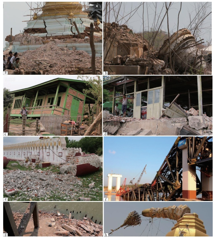
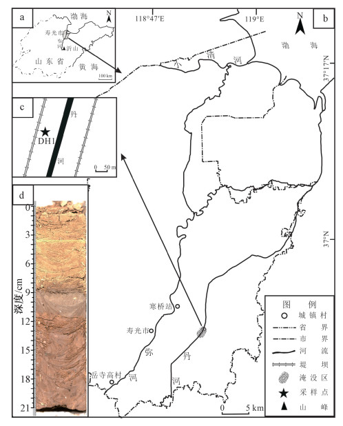
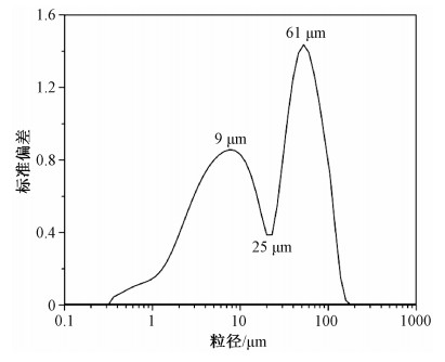
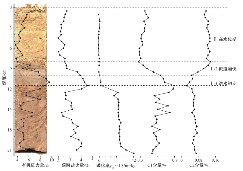
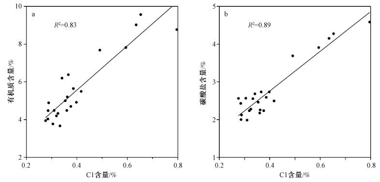
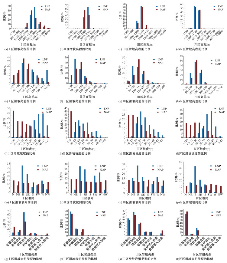
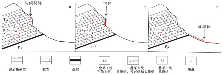
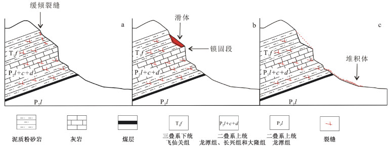
2022 Vol. 28, No. 2

Display Method:
Cover Page
2022, 28(2): .
Abstract (68) PDF (1505KB)(21)
Abstract:
Contents
2022, 28(2): 154-154.
Abstract (153) PDF (469KB)(49)
Abstract:
Surface rupture investigation of the 2022 Menyuan MS 6.9 Earthquake, Qinghai, China: Implications for the fault behavior of the Lenglongling fault and regional intense earthquake risk
HAN Shuai, WU Zhonghai, GAO Yang, LU Haifeng
2022, 28(2): 155-168. doi: 10.12090/j.issn.1006-6616.2022013
Abstract (1852) HTML (214) PDF (38741KB)(165)
Abstract:
The MS 6.9 Menyuan earthquake on January 8, 2022 occurred in the Qilian Mountain fault block in the northeastern margin of the Tibetan Plateau. The instrumental epicenter is located in the Lenglongling fault zone in the west section of the Haiyuan active fault system. It is another strong earthquake with M>6.5 that occurred in the fault system after the Haiyuan M 8.5 earthquake in 1920. The preliminary conclusion of the investigation results shows that the Menyuan earthquake generated two main fracture zones in the south and north separately, which are distributed in left-step oblique arrangement with a total length of nearly 23 km, and there is a surface rupture cavity with a length of about 3.2 km and a width of nearly 2 km between them. The south branch rupture (F1) appears in the east section of the Tuolaishan fault, striking 91°, with a length of about 2.4 km. It is mainly characterized by southward thrust and sinistral strike slip, with a maximum horizontal displacement of nearly 0.4 m. The north branch main rupture (F2) appears in the west section of the Lenglongling fault, with a total length of nearly 20 km. It is mainly sinistral strike-slip deformation, and presents an overall slightly convex arc distribution to the northeast, including the west, middle and east sections of 102°, 109° and 118°, respectively. The maximum strike-slip displacement occurs in the middle section, which is 3.0±0.2 m. In addition, a new north branch secondary fault (F3) with a cumulative length of about 7.6 km, dominated by normal-dextral fault, is discovered on the north side of the middle to east section of the main fault of the north branch, with a cumulative maximum horizontal displacement of about 0.8 m and a maximum normal vertical displacement of about 1.5 m. Comprehensively, the whole coseismic rupture is mainly sinistral strike-slip and has the characteristics of bilateral rupture, whereas the macroscopic epicenter is located in the north branch of midway through the main fracture zone, thus the strike-slip displacement of the surface may be associated with the shallow rupture of the source. The normal-dextral rupture is likely to be caused by the differential movement of the north block dragged by the active south plate. The south Qilian block was extruded eastward along the Haiyuan sinistral strike-slip fault system due to the strong collision and compression between the Indian and Eurasian plates, which led to the simultaneous rupture of the Tuolaishan fault and the Lenglongling fault. This is the main dynamic mechanism leading to the strong earthquake. Under the background of continental dynamics, further attention should be paid to the future strong earthquake risk of the Qilian Mountain fault block and its surrounding area with the Haiyuan sinistral strike-slip fault system as the main boundary.
The 2012 Thabeikkjin (Myanmar) M 7.0 earthquake and its surface rupture characteristics
CHANG Zufeng, ZHANG Jianguo, SHEN Chongyang, LI Chunguang, LIU Changwei, WANG Guangming, YU Jiang
2022, 28(2): 169-181. doi: 10.12090/j.issn.1006-6616.2021161
Abstract (466) HTML (171) PDF (44424KB)(51)
Abstract:
Based on the first-hand data obtained from the field survey in terms of geology, landforms, earthquake ruins, this paper focuses on the activity behavior of the Sagaing fault, as well as the damaged buildings and seismic surface rupture zone generated by the 2012 earthquake. The Sagaing fault striking nearly NS is an active large-scale dextral strike-slip fault, with a horizontal slip rate of 18~20 mm/a. Many strong earthquakes more than M 7 have occurred along the Sagaing fault zone historically, and so far, there are still ruins of the earthquakes, such as the 1839 Innwa, Mandalay, M 8 earthquake, the 1930 Bago M 7.3 earthquake and the 1930 Phyu M 7.3 earthquake. The 2012 Thabeikkjin M 7.0 earthquake caused serious damage to pagodas, civil and other buildings, forming an at least 45 km-long seismic surface rupture with bank collapses, landslides, seismic faults and so on. The epicenter intensity of the earthquake is estimated to be IX. Under the dextral strike slip of the fault, the ground fissures show a trend of regular left-step en echelon, and the included angle with the strike of the Sagaing fault is generally 20°~30°; The large-scale ground fissures mostly show a "S" type. The regular left-step en echelon trend of ground fissures and the faulted ground features indicate that the seismic surface fracture are obviously characterized by dextral strike slip. The horizontal dextral displacements caused by the 2012 earthquake are generally between 40~90 cm, and the maximum reaches 102 cm. The surface rupture characteristics and the results of focal mechanism solutions show that the event is caused by the dextral strike-slip of the Sagaing fault.
Deformation asymmetry in foreland thrust belts and the kinematic direction of the related thrust faults
CHEN Shuping, WAN Huachuan, YUAN Haowei, WANG Xinpeng, HUANG Xueyao
2022, 28(2): 182-190. doi: 10.12090/j.issn.1006-6616.2021080
Abstract (360) HTML (167) PDF (1800KB)(70)
Abstract:
The thrust directions in foreland thrust belts have not been explained on theory. Based on Coulomb fracture criterion and deformation asymmetry in foreland thrust belt, the origins of fore-thrust and back-thrust faults are analyzed in this paper. Two potential conjugate fractures would occur in initial deformation stage, and the fracture requiring less applied forces might develop into thrust fault under the quasi-static equilibrium caused by deformation asymmetry in foreland thrust belts. The applied forces needed to create fault movements include the frictions along both the detachment surface and the fault surface. The fore-thrust faults will occur in most deformations in foreland thrust belts. However, where either the principal stress axes tilt toward foreland or the intersections point of the two conjugate fractures are on the detachment surface, the back-thrust faults will be preferable to occur. The applied force, the frictions along the detachment surface and the geometries of the slipping terranes will determine the principal stress axes. The findings will help to explain the selectivity of the fault dips in both contractional and extensional deformation areas.
Study on the hydraulic fracturing in-situ stress measurement in super-long highway tunnels in southern Shaanxi:Engineering geological significance
LI Bin, ZHANG Wen, WEN Ran
2022, 28(2): 191-202. doi: 10.12090/j.issn.1006-6616.2021053
Abstract (502) HTML (134) PDF (14024KB)(90)
Abstract:
The complex terrain and marked anisotropy of regional tectonic stress field in western China make the crustal stress state an important assessment parameter. Understanding the regional crustal stress state lays the foundation for assessing the layout at the tunnel design stage and predicting rockburst, fault slip and other engineering disasters in the tunnel construction process. This study aims to explore the current in-situ stress state of the super-long highway tunnels in southern Shaanxi. We did hydraulic fracturing in-situ stress measurement of the Boreholes ZK10 and ZK11 in the Guxiandong tunnel and the Hualongshan tunnel, respectively, and thus characterized the current in-situ stress distribution of the two tunnels. The measurement results show that:The SH values at the maximum buried depths of the Guxiandong and Hualongshan super-long deep tunnels are 13 MPa and 22 MPa, respectively. The stress relations of the Guxiandong and Hualongshan tunnels are SH>Sh>Sv and SH>Sv>Sh, respectively, and horizontal principal stress plays a leading role. The SH direction is NW-NWW, which is basically consistent with the direction of the maximum principal stress in the basic database of crustal stress environment in mainland China. Three conclusions were drawn from the results of in-situ stress measurement in combination with related theories and assessment criteria. Firstly, the angle between the direction of maximum horizontal principal stress and tunnel axis is beneficial to the stability of tunnel surrounding rocks. The overall layout of the two tunnels is reasonable. Secondly, rock burst with moderate strength or above will not occur in the two tunnels according to a comprehensive study using the rock strength-stress ratio method, Tao Zhenyu criterion, Russenes criterion and rock stress-strength ratio method. Thirdly we used Mohr-Coulomb criterion and Bayer's law, let the friction coefficient μ have the value between 0.6~1.0, and then we analyzed the present stress state of the two tunnels. It is found that the stress of the fault zone near the two tunnels did not reach the critical condition of sliding instability of shallow faults in the crust, while it is in a stable stress state.
The factors influencing the enrichment of organic matters in the Carboniferous source rocks, Ounan depression, eastern Qaidam basin
SHI Hui, LI Zongxing, YANG Yuanyuan, PENG Bo, HU Junjie, FANG Xinxin, ZHANG Hao, WEI Xiaojie
2022, 28(2): 203-216. doi: 10.12090/j.issn.1006-6616.2021135
Abstract (493) HTML (99) PDF (24117KB)(46)
Abstract:
The Ounan depression is a favorable structural unit for the Carboniferous hydrocarbon migration and accumulation, which demonstrates certain exploration potential. However, the organic matter enrichment mechanism is still unclear, which results in the absence of effective guidance for predicting the distribution of high-quality source rocks and restricts the process of oil and gas exploration. Based on geochemical analysis and XRD, SEM and other tests, the main factors influencing the enrichment of organic matters in Carboniferous source rocks have been identified through a comprehensive investigation into the aspects such as mineral composition, organic matter abundance, kerogen type, thermal evolution degree, formation environment, and the relationship between TOC and primary minerals. The results reveal that shales and carbonate source rocks have been developed in the Carboniferous, a large quantity at poor-medium level and a few at good or above level. They were deposited in the environment of intercontinental shelf with saline-water, arid-hot climate and weak oxidation and reduction. The dispersed organic matters are composed of mixed marine and terrestrial origins, which are overall in a "maturity-high maturity stage". The Carboniferous clastic source rocks are mainly residual type Ⅲ kerogen, but the extracted chloroform bitumen "A" is mainly derived from type Ⅱ kerogen.TOC values increase with the growing of quartz minerals because the high-abundance source rocks are rich in siliceous biological fossils. The SiO2 in the high-SiO2 source rocks has been identified as biogenic, suggesting that the participation of siliceous organisms in the Carboniferous cause the enrichment of marine organic matters and greatly improve the primary productivity of the sediments. This study provide the basis for predicting the distribution of Carboniferous high-quality source rocks and the deployment of oil and gas resources in the study area.
Study on influencing factors of oil-water partition coefficient of phenolic compounds
SUN Yanze, PENG Xiaobo, WEN Zhigang, HE Wenxiang, YAN Gang, LIU Xu, ZHONG Ming, TIAN Weichao
2022, 28(2): 217-225. doi: 10.12090/j.issn.1006-6616.2021176
Abstract (458) HTML (114) PDF (6347KB)(16)
Abstract:
Alkylphenols are a kind of compounds produced by alkylation of phenolic compounds. Compared with other non-hydrocarbon compounds, alkylphenols are more soluble in water. In this paper, through three groups of oil-water distribution experiments at different temperatures (25 ℃, 45 ℃ and 65 ℃), different brine concentrations (4000 mg/L, 6000 mg/L and 8000 mg/L) and different crude oil types (X37, X45 and X61), the distribution characteristics of alkylphenols between oil and water were studied, and the variation law of alkylphenol distribution coefficient was determined. The results show that the oil-water partition coefficient increases with the increase of alkyl molecular weight of homologues; The oil-water partition coefficient of alkylphenols decreases with the increase of temperature, and alkyl homologues with higher molecular weights are more sensitive to temperature; The partition coefficient of alkylphenol in oil-water system increases with the increase of water salinity. According to the experimental results, temperature and salinity of water phase will cause the difference of oil-water partition coefficient of alkylphenol, and the influence of temperature is greater than that of salinity. The distribution behavior of alkylphenols between oil and water can provide more reference for the secondary migration of crude oil and the direction of water drive front in reservoir development.
Sedimentary characterization and provenance analysis of the 2018 flooding along the Dan River, Shandong, and the hydrodynamic process reconstruction
LI Huayong, ZHAO Nan, YANG Yiping, YU Zhengsong, SUN Qifa, WU Shuaihu, ZHANG Man, ZHANG Hucai
2022, 28(2): 226-236. doi: 10.12090/j.issn.1006-6616.2021112
Abstract (449) HTML (117) PDF (7532KB)(39)
Abstract:
Sedimentary characterization of modern floods helps to reconstruct the hydrologic flood process and spot the source area of sediment erosion. It is of great referential value both to the design of flood-control works and the identification of paleo-flood layers. In mid-August 2018, two typhoons battered the Dan River Basin in northern Shandong, leading to flooding disasters. Based on the research of the flooded area, the boreholeDH1 of 21 cm long was obtained from the downstream with well-preserved flood sediments. The analyses on its grain size, loss on ignition, magnetic susceptibility, and sporo-pollen features, show that the sedimentary cycle under flooding is characterized by fine grains in the lower part and coarse grains in the upper part. Modern soil is developed at a depth of 11.5~21.0 cm; a typical flood silt layer is developed at a depth of 0~9.0 cm, which is relatively coarse in grain size, dominated by medium-to-coarse-grained silt, and with a sand content of 14.7% on average; and a fine-grained sedimentary layer is developed at a depth of 9.0~11.5 cm during the initial period of flooding. According to the various traits of sensitive component contents, the flooding process can be divided into two stages: the relatively weak hydrodynamic force at the earlier stage and the significantly accelerated flow velocity at the later stage; The former is characterized by severe vicious flow and deposition of clays under the combined action of natural conditions and human activities, which can be further divided into two sub-sections of the rising water level and the significant acceleration of flow velocity; The latter result in typical silty deposits from flooding. Carbonate, organic matter content, and sporo-pollen abundance all are negatively correlated with grain size, indicating that the weak hydrodynamic environment is conducive to its deposition and accumulation. The sporo-pollen assemblage of the surface soil can better indicate the distribution of vegetation in the study area, and the sporo-pollen assemblage of the silty layer from flooding can better reflect the overall condition of vegetation in the basin, which has revealed that the river flood is much greater than wind in transporting sporo-pollen. In addition, the sporo-pollen assemblage features in the clayey layer from flooding are in good agreement with the distribution of vegetation in the study area, and obviously different from those of the silty layer from flooding, according to which it is speculated that the primary cause of the water level rise during the initial period of flooding lies in precipitation incorporating with local surface runoff; therefore, the sediment and sporo-pollen are derived from within the study area, and meanwhile the influx of tourists in the later period has brought in more sporo-pollen from mountainous vegetation. The sporo-pollen deposition records from borehole DH1 show that the sporo-pollen assemblage features are in good response to the propagation process and hydrodynamic force, and have the potential to identify the source area of sediment erosion. The magnetic susceptibility mainly reflects the intensity of pedogenesis, and its value for both the clayey and silty layers from flooding is steadily low, significantly lower than that for the soil contact layer. Therefore, it can be used as a reliable indicator for identifying flood deposits, but the geospatial scope of their use needs to be further discussed.
Geochronological and geochemical characteristics of the Caledonian Longquan pluton in southern Zhejiang, and their geological significance
LIU Yuandong, SU Xiaolang, CHENG Haiyan, ZHANG Jianfang, LI Xiang, LIU Fenglong
2022, 28(2): 237-256. doi: 10.12090/j.issn.1006-6616.2021093
Abstract (400) HTML (177) PDF (18081KB)(51)
Abstract:
The Longquan pluton is a rare Caledonian granitic rock mass in southern Zhejiang. Studies on the Longquan pluton using petrology, geochemistry, and chronology were conducted in this paper, which reveal that it is composed of granite-monzogranite assemblage (granitoid) and tonalite-trondhjemite-granodiorite assemblage (TTG). The two types of rocks are generally enriched in large ion lithophile elements Rb, Ba, Th, U and K, and depleted in high field strength elements Nb, Ta, P and Ti, showing the characteristics of island arc magmatic rocks. The geochemical characteristics of the TTG rocks show that they belong to the typical high-pressure type TTG, and its magma originated from the remelting of the basic lower crust under the action of subducted slab fluid. While the granitoids were mainly derived from partial melting of ancient crustal sediments. Neither of them was significantly contaminated by mantle. The zircon SHRIMP U-Pb and LA-ICP-MS U-Pb dating results show that the Longquan pluton was formed between 443±3 Ma~410±3 Ma. Combined with its petrological and geochemical characteristics, it is indicated that the subduction of oceanic crust had still existed in the Longquan area until early Devonian.
Analysis on the development law of active geological hazards in the Loess Plateau based on InSAR identification
YAO Chuangchuang, YAO Xin, GU Zhenkui, REN Kaiyu, ZHOU Zhenkai
2022, 28(2): 257-267. doi: 10.12090/j.issn.1006-6616.2021083
Abstract (766) HTML (216) PDF (33862KB)(124)
Abstract:
Active geological disasters induced by earthquakes, rainfalls and human engineering activities occur frequently in the Loess Plateau. However, there is a lack of systematic understanding of the development and distribution of active geological disasters in the Loess Plateau due to the wide area, active structure, diverse landforms and great difference in loess characteristics. InSAR technology can observe surface deformation in a wide range. Based on 40 sentinal-1 SAR data from January 1, 2019 to March 31, 2020, a total of 3286 active geological disasters in the Loess Plateau of 624, 600 km2 were interpreted by InSAR, including 1135 landslides, 1691 mining collapses, 368 subsidences and 92 landfills. Combined with geomorphological and optical image characteristics, four types of active geological hazards were interpreted, which reveals that they are mainly distributed in eight regions, including four landslide areas, three mining collapse areas and one subsidence area. The spatial distribution of active landslides is obviously regional and clustered, concentrating in the middle and west of China; while that of mining collapse and land subsidence densely developed in groups in the middle and west of China. There is a relationship between landslide development density and topography. The development of these geological disasters has an obvious spatio-temporal regularity. Regionally, the development intensity of geological disasters is controlled by topography and mineral resources; and in terms of scale, disasters identified by InSAR are all above medium size, which is different from traditional statistical methods. InSAR identification results objectively reflect the distribution of geological disasters in the Loess Plateau, and deepened our understanding on that as well. InSAR technique, meanwhile, can effectively detect the surface damage induced by underground coal mining, including its distribution, scope, strength, and monitor the depth and scope of opencast coal mine, and then infer the intensity of coal production activities.
Identification and risk assessment of coal mining-induced landslides in Guizhou Province by InSAR and optical remote sensing
ZHU Yifei, YAO Xin, YAO Leihua, ZHOU Zhenkai, YAO Chuangchuang, XIAO Shihao
2022, 28(2): 268-280. doi: 10.12090/j.issn.1006-6616.2021054
Abstract (610) HTML (196) PDF (37900KB)(85)
Abstract:
The Zongling landslide group in Guizhou Province is characterized by strong regularity of disaster formation, concentrated development and severe threat. It is represented in the coal mining-induced geological hazards in western Guizhou and eastern Yunnan. In this paper, InSAR and optical remote sensing were used for nuanced identification to obtain the regional landslide information, and the landslide deformation-failure mode in the Zongling region was summarized. Based on this, the volume-distance statistical formula suitable for landslide risk assessment in this region was established, and the typical disaster bodies ware calculated. Some important insights are gained: Underground coal mining is the major contributor to the deformation of the edge of Table Mountain in Zongling. InSAR observation results show that the deformation in the Zongling area has prominent zonal characteristics, and the annual average deformation velocity is between -20.4~10.2 cm/a, which corresponds well with the lower goaf. The areas with great displacement are concentrated in the edge zone of cuesta, with coal mining subsidence and slope gravity superimposed; There are 64 deformations in the Zongling area, including 37 landslides, 27 cracks, and 2 dangerous deformed bodies. Landslides mainly occur in the dark grey limestone strata and dark purplish-red argillaceous siltstone strata of the Feixianguan Formation. According to the lithology and deformation characteristics of the slip source, the landslides can be classified into two types: pull-toppling and pull-clipping, and the former is distinguished by large particle size, long movement distance, and severe threat. The formula for calculating the slip distance of rock landslide debris flow has good applicability to the slip distance of coal mining-induced landslide developed in the "upper hard and lower soft" strata in the Zongling area, and the verification error is less than 5%. The formula is used to calculate the dangerous deformed bodies of Zuojiaying and Jingjiao in the study area, and the danger avoidance distance is predicted to be 220~386 m. The proposed method of coal mining-induced landslide risk assessment based on differential interferometry and optical image play an exemplary role for the prevention and control of coal mining-induced landslides in western Guizhou and eastern Yunnan.
The applicability assessment of Sentinel-1 data in InSAR monitoring of the deformed slopes of reservoir in the mountains of southwest China: A case study in the Xiluodu Reservoir
LI Lingjing, YAO Xin, ZHOU Zhenkai, WANG Defu
2022, 28(2): 281-293. doi: 10.12090/j.issn.1006-6616.2021109
Abstract (487) HTML (140) PDF (27823KB)(90)
Abstract:
Sentinel satellite is widely used in deformed slope identification and monitoring due to its high resolution, stable orbit system, large coverage capacity, short repetition time, and free data download. Since the 1963 catastrophic landslide of Vaiant in Italy, the geologic hazard on bank slopes has been one of the main problems of the reservoir in the mountainous area. Taking the Xiluodu reservoir in the upper reaches of the Jinsha River as the study area, the applicability of the Sentinel-1 SAR data in InSAR monitoring of deformed slopes of reservoir in mountainous areas was evaluated by combining PALSAR-2 and TerraSAR-X data. The results were used to evaluate whether Sentinel-1 data could replace other commercial SAR data under certain conditions. It provides a reference for future applications in related researches. The results show that: About 200 deformed slopes were interpreted by the Sentinel-1 data in the study area, including landslide, rockfall, and bank collapse. According to field investigations, the minimum projected area of deformed slope based on the Sentinel-1 data is about 2400 m2, a size of 35 m (length)×77 m (width), gathered by 16 high-value raster pixels. Overlapping mask shadow phenomenon is severe in the alpine valley area. By comparing SAR data in common satellite radar observation modes, the effective observation area is 70.3% of the ascending Sentinel-1 orbit, 68.9% of the descending Sentinel-1 orbit, 70.4% of the ascending PALSAR-2 orbit, 67.6% of the descending PALSAR-2 orbit, and 52.5% of the descending TerraSAR-X orbit in the intersection area of all SAR data used. Without considering the resolution, it can be concluded that the Sentinel-1 data in the reservoir area has an equal or more excellent observation ability than the other two SAR data. The water level rises from June to early November, and the currounding vegetation develops well, resulting in poor data coherence. Since 2017, the amount of SAR data acquired by Sentinel-1A (1B) has increased, and high-frequency observations can improve the coherence. Therefore, the SAR data can be used to effectively identify the development and change of regional deformed slopes during the water fluctuation cycle. When the SAR data is lacking for a long time, the deformation measured by some pixels between the nearest pair of SAR data could exceed the maximum InSAR measurement range, and the phase period will be lost during the unwrapping. Sentinel-1 SAR data is more suitable for trend identification of continuous small deformations due to its good continuity.
Evaluation of geohazard susceptibility based on information value model and information value-logistic regression model: A case study of the central mountainous area of Hainan Island
LI Xin, XUE Guicheng, LIU Changzhu, XIA Nan, YANG Yongpeng, YANG Feng, WANG Xiaolin, CHANG Zhenyu
2022, 28(2): 294-305. doi: 10.12090/j.issn.1006-6616.2021111
Abstract (571) HTML (180) PDF (15280KB)(75)
Abstract:
As the basis of geohazard risk evaluation, the geohazard susceptibility evaluation can objectively and accurately reflect the probability of geological hazard occurrence by using quantitative mathematical statistics. This article takes Wuzhishan city, where occurs the most geohazards in Hainan Island, as an example. Factors including structure, rock formations, slopes, topographic undulations, altitude variation coefficients, normalized differential vegetation index (NDVI), rainfall, river systems, roads, and curvatures were selected as evaluation indicators and applied in both information value model and information value-logistic regression model. In the end, by comparing and analyzing the accuracy and adaptability of both models, the article ends with the conclusion that the high-prone areas are mainly distributed along roads and rivers in the mountainous areas, and the extremely low-prone areas are mainly located in the areas where have no rivers, valleys and human activities. In addition, the results also revealed that the prediction accuracy meets the requirements of susceptibility evaluation owing to the high AUC (area under the curve) values occupying 0.897 and 0.896 respectively in both models. Evaluation factors such as rainfall, elevation variation coefficient and highway play a remarkable role on the development of geohazards. Furthermore, it is indicated by experiments that the information value-logistic regression model has better prediction accuracy than the other. The research results provide a scientific and effective discrimination method and a prediction approach for geohazard risk evaluation in this area.
Hazard assessment of debris flows in Kongpo Gyamda, Tibet based on FLO-2D numerical simulation
ZHANG Haowei, LIU Fuzhen, WANG Junchao, ZHANG Jiajia
2022, 28(2): 306-318. doi: 10.12090/j.issn.1006-6616.2021117
Abstract (451) HTML (187) PDF (47607KB)(80)
Abstract:
Kongpo Gyamda is located in eastern Tibet, where debris flows occur frequently in the rainy season, which has a serious impact on local people's daily life and hinders regional economic construction and development. In order to study the hazard characteristics of small to medium-sized debris flow in eastern Tibet and potential dangers to urban residential areas, the FLO-2D software was used to study five debris flow gullies with relatively concentrated residents around Kongpo Gyamda. The scouring and silting characteristics of debris flows were simulated. Based on the simulation results in terms of depth and velocity, the intensity and hazard zoning of debris flows were determined. By analyzing the topological relationship between the debris flow danger zone and the residential area, the debris flow risk around the county was evaluated. It provides technical reference for the town planning, and disaster prevention and mitigation in Kongpo Gyamda.