2025 Vol. 31, No. 3

Cover Page
Cover Page
2025, 31(3)
Abstract (185) PDF (1560KB)(24)
Abstract:
Contents
2025, 31(3): 1-2.
Abstract (152) HTML (91) PDF (427KB)(28)
Abstract:
Special Section Dedicated to the 30th Anniversary
Analysis of historical seismic parameters based on geological hazards from the Xiaonanhai earthquake
GONG Liwen, ZHANG Huai, CHEN Lijuan, WANG Zanjun, ZHANG Bingnuo, SUN Yixing, BAI Changyun
2025, 31(3): 345-360. doi: 10.12090/j.issn.1006-6616.2025001
Abstract (813) HTML (198) PDF (23192KB)(61)
Abstract:
  Objective  As the largest historical seismic event in the Chongqing region, the Xiaonanhai Earthquake holds significant scientific value for deciphering seismogenic parameters to inform regional seismic hazard assessment and anti-seismic fortification standards. This study addresses the critical challenge of scarce observational data in historical earthquake research.   Methods  A novel methodology for inverting seismic parameters through characteristic earthquake relics has been developed, systematically reconstructing the historical seismic parameters of the Xiaonanhai Earthquake. The interpretation of high-precision remote sensing and field investigations of seismically induced geo-hazards reveal a dominant near-N–S spatial distribution of the landslide clusters triggered by the Xiaonanhai Earthquake, consistent with the elliptical major axis direction of historically documented felt areas.   Results  This spatial congruence suggests that the NNW-striking Yangtoushan Fault is the seismogenic fault. Detailed remote sensing analyses of landslide orientations, sliding directions, and deposit distributions demonstrate, for the first time, coherent SE-directed motion features across multiple landslide masses, indicating a southeastward coseismic rupture propagation. A comparative analysis of the spatial correlation between geo-hazards and seismogenic structures observed in the Ludian Earthquake, coupled with seismotectonic mechanisms in southeastern Chongqing, further validates the rationality of the derived seismic parameters.   Conclusion  This study innovatively identifies a "karst–tectonic" composite mechanism: Under persistent NW–SE tectonic stress, bead-like karst caves developed along the fault zone or dominant joint directions form natural weakening zones, inducing stress concentration and ultimately triggering left-lateral strike-slip motion with thrust components. This dual mechanism explains the unique seismic characteristics blending tectonic rupture and karst collapse. [Significance] The proposed "geo-morphodynamic inversion" methodology advances the reconstruction of historical earthquake parameters and provides critical insights for the evaluation of seismic risk in karst terrains.
The outward growth of the arcuate tectonic belt in the northeastern Tibetan Plateau: Insights from three-dimensional finite element numerical simulations
ZHAO Yilin, SUN Yujun, HOU Guiting, SHI Wei
2025, 31(3): 361-385. doi: 10.12090/j.issn.1006-6616.2025037
Abstract (647) HTML (182) PDF (7137KB)(89)
Abstract:
  Objective  The arcuate tectonic belt in the northeastern Tibetan Plateau is a unique boundary for the lateral growth of the Tibetan Plateau. Characterized by an arcuate geomorphology with alternating basins and mountains perpendicular to the direction of plateau expansion, it represents a unique growth mode of the Tibetan Plateau. This study aims to reproduce the formation and evolution process of the arcuate tectonic belt in the northeastern Tibetan Plateau using three-dimensional finite element visco-plastic large deformation numerical simulation. It also proposes a new structural pattern and deformation mechanism for the outward growth of the arcuate tectonic belt.  Methods  Three tests based on a large amount of geological and geophysical data were conducted to investigate how the barrier of the Yinchuan Basin and the weak lower crust control the development of faults within the arcuate tectonic belt.   Results  The results show that, as the Tibetan Plateau expanded northeastward, the shortening and thickening of the crust propagated from the plateau to the northeast. Under NE–SW compression, the deep-seated materials in the Mesozoic and Cenozoic basins (arcuate tectonic belts), which were confined by blocks, migrated northeastward. After being blocked by the rigid Ordos and Alxa blocks, these materials were squeezed into the relatively weak Yinchuan Basin to a limited extent. The obstruction by the Yinchuan Basin is an important condition for the formation and development of the faults within the shallow crust of the arcuate tectonic belt. A weak lower crust with a viscosity of 2.5×10²² Pa·s and a cohesion of 2 MPa promotes fault development within the arcuate tectonic belt, but it is not a necessary prerequisite for fault formation. This paper analyzes the distribution of the maximum shear strain rate on the surface and along three sections of the arcuate tectonic belt as well as the evolution of these characteristics over time. It is proposed that the arcuate tectonic belt generally exhibits a "ramp-thrusting" structural pattern in the deeper sections, and the deformation mechanism is characterized by deep–shallow decoupling. The deformation of the lithosphere within the arcuate tectonic belt decoupled at depths of 20 km and 40 km, forming three tectonic layers. The middle–upper crust is dominated by thrust and fold structures, regulating the horizontal shortening and vertical thickening of the crust; the weak lower crust completes the horizontal shortening and vertical thickening of the crust through ductile–plastic deformation and serves as a detachment layer for the development of arcuate structures; the lithospheric mantle, due to the regulating effect of the Moho surface, underwent limited shortening and thickening.   Conclusion  Under the control of the preexisting fault zones in the southern and northern margins and the detachment zones, the main arcuate faults developed synchronously during the period of 9.5–2.5 Ma. Then, they extended in depth and finally cut into the middle crust. [ Significance ] This study deepens the understanding of the uplift and lateral growth of the Tibetan Plateau, and provides a reference for the study of the deep–shallow processes involved in arcuate structure formation.
Structural deformation and geochronology of the ductile shear zone along the southern margin of the Foping dome, South Qinling
YU Kecheng, SUN Shengsi, DONG Yunpeng, HUI Bo, CHENG Chao, ZHANG Bin, ZHANG Yining, LI Xinyu
2025, 31(3): 386-410. doi: 10.12090/j.issn.1006-6616.2025008
Abstract (710) HTML (134) PDF (6565KB)(82)
Abstract:
  Objective  A typical granulite–migmatite–gneiss dome developed in the Foping area of the central Qinling orogenic belt. This area is key to studying the metamorphic deformation of continental crust and the Mesozoic tectonic evolution of Qinling. The Yangtianba–Shimudi ductile shear zone along the dome's southern margin records information on middle–deep structural deformation during the late Triassic compressional–extensional transition, offering crucial constraints on the exhumation mechanism of the Foping dome.   Methods  A detailed investigation of representative metamorphic and deformed rock samples from the shear zone was conducted using structural analysis, mineral geochemistry, crystallographic preferred orientation (CPO), and geochronology. Field observations and kinematic vorticity analysis show that this shear zone developed under right-lateral ductile shear deformation controlled by pure shear.   Results  In the felsic mylonite, quartz primarily shows prism <a> and prism <c> slip systems, suggesting deformation occurred under amphibolite facies conditions at approximately 550–650 °C. The characteristics of the metamorphic mineral assemblages and the results of garnet–biotite–plagioclase thermobarometry indicate a clockwise P–T path, with peak metamorphic conditions of 568–611 °C/5.2–5.3 kbar and 630–654 °C/7.1–7.9 kbar. The isothermal decompression stage M2 recorded conditions of 590–616 °C/3.5–4.5 kbar. Zircon U–Pb dating of the leucosomes in the migmatites within the shear zone yielded an age of 180.8 ± 3.8 Ma, representing the lower limit of the ductile shear deformation.   Conclusion  Integrated with regional geological data, the metamorphic and deformational evolution of the study area can be reconstructed as follows: Prior to ~210 Ma, the central segment of the South Qinling tectonic belt was dominated by collisional orogenesis, leading to crustal thickening and the development of progressive metamorphism (M1) in the Foping area. During 210–200 Ma, the Foping region transitioned into post-collisional extension. This transitional phase was characterized by a bidirectional stress regime combining horizontal shortening and vertical collapse, which triggered ductile shear deformation (D1) in the Yangtianba-Shimudi area and initiated the isothermal decompression metamorphic event (M2). The region entered a phase of post-collisional extension at about 180 million years. Continued extension resulted in the formation of partial melts in the northern part of the study area. During the subsequent exhumation of the ductile shear zone, the mylonitic foliation was reformed by late fold deformation. [Significance] The findings provide a reference for discussing the detailed process of metamorphic deformation response in the process of Late Triassic–Early Jurassic tectonic transformation in the south of Foping dome.
Tectonic System & Structural Geology
Tectonic geomorphological evidence of late Quaternary segmented activity along the northern margin fault of Lajishan
ZHANG Lijun, YUAN Daoyang, LI Hongqiang, SU Qi, SU Ruihuan, CHEN Yanwen, WEN Yameng
2025, 31(3): 411-426. doi: 10.12090/j.issn.1006-6616.2024125
Abstract (579) HTML (146) PDF (7626KB)(102)
Abstract:
  Objective  The Lajishan–Jishishan orogenic belt represents a significant arc-shaped tectonic zone formed by northeastward compressional expansion along the northeastern margin of the Tibetan Plateau, jointly controlled by two compressional thrust fault zones: the North Lajishan Fault and the South Lajishan fault. Since the Late Cenozoic, intense tectonic activities in the Lajishan area have created a prominent basin–range coupled geomorphological pattern, making it an ideal region for investigating the geomorphic evolution and the tectonic dynamics through structural geomorphological approaches.   Methods  Based on a 30-m-resolution digital elevation model (DEM), this study employs the ArcGIS and MatLab platforms with plugin tools and open-source code packages to extract channel steepness indices (Ksn) from 105 medium- and small-sized rivers on the hanging wall of the North Lajishan Fault (including the East Jishishan Fault), along with hypsometric integrals (HI) from 54 watersheds along the fault zone.   Results  The Ksn distribution reveals an overall west-to-east increasing trend in uplift rates along the North Lajishan fault, with a notable low-value anomaly in its central segment. Statistical analysis of Ksn demonstrates clear segmentation characteristics, indicating that the eastern section of northern Lajishan and the Jishishan section exhibit the highest uplift rate and strongest tectonic activity. HI spatial distribution patterns along the North Lajishan fault show multiple high-value zones within piedmont basins. Integrated with geological surveys and petroleum exploration profiles, these findings suggest that during the Late Quaternary, the North Lajishan fault has not only remained active but also propagated northeastward into the Xining–Minhe and Linxia basins, exhibiting thrust fault–fold deformation features.   Conclusion  (1) The tectonic geomorphological evolution of the North Lajishan Fault (including the eastern margin of Jishishan) is obviously different, and it tends to gradually become younger from west to east. The geomorphological evolution of the northern margin of Lajishan has discrete differences, which can be attributed to three sections: a western, a middle, and an eastern section, which includes the northern margin of Jishishan. Among them, the tectonic activity of the latter section is the latest and most intense, consistent with the long-term tectonic evolution. This confirms the rationality of the geomorphological parameter extraction results and is also a geomorphological response to the differential tectonic activity in this area. (2) The tectonic activity characteristics of the northern margin of Lajishan (including the eastern margin of Jishishan) adhere to the geomorphological evolution law and also have segmental differences. It is believed that the North Lajishan Fault (including the East Jishishan Fault) has strong tectonic activity from west to east. Specifically, the uplift rate of the western section of the northern margin of Lajishan is stable. The tectonic activity may be superimposed on the strike-slip component of the Riyueshan Fault in addition to the regional extrusion uplift, which was active in the Late Pleistocene and dominated by left-handed strike-slip and thrust. The middle section of the northern margin of Lajishan (NE-trending bulge section) has the lowest tectonic uplift rate, and the fault in this section is dominated by extrusion thrust with a late Pleistocene activity; it is little affected by the Riyueshan fault. The eastern section of the northern margin of the Lajishan-Jishishan section (the fault arc protrudes to the south-east turning section) has strong tectonic activity with Holocene fault activity; its nature is mainly thrust with dextral components. Significance In addition to its late Quaternary activity, the North Lajishan Fault (including the East Jishishan Fault) tends to expand and develop into the piedmont basin. Combined with the comprehensive interpretation of field geological surveys and oil exploration sections, it is believed that the fault extends to the interior of the Xining–Minhe Basin to form a reverse fault–fold belt. Its latest tectonic activity may have triggered more than 10 moderate–strong earthquakes. Attention should be paid to this tectonic activity and the related seismicity in those basin.
Fault damage zone and its unmanned aerial vehicle identification technology
CHEN Zebang, YUN Long, WANG Ju, TIAN Xiao
2025, 31(3): 427-443. doi: 10.12090/j.issn.1006-6616.2024089
Abstract (377) HTML (140) PDF (3126KB)(59)
Abstract:
  Objective  In structural geology, faults and their damage zones are fundamental structural units that hold significant research and engineering value. They can be usde to reveal the evolution laws of regional structures and the evolution characteristics of fault structures, to indicate the migration paths of underground fluids, and to evaluate the stability of major engineering rock masses. However, traditional research methods often rely on manual recording to obtain information on fractures and surrounding joint structures, which suffer from inefficiency and susceptibility to limitations imposed by complex terrain. The emerging unmanned aerial vehicle (UAV) aerial survey technology in recent years has effectively addresses the limitations of traditional methods. This method integrates data acquisition, terrain mapping, and dynamic monitoring. It generates high-resolution digital models and images that can more effectively reduce field workload, more intuitively display terrain features, and more conveniently extract structural information. This method can be applied more broadly to the field of structural geology and geological engineering, especially when studying faults and damage zones.   Methods  Based on an extensive literature review, we categorized and compared existing research in relation to different application scenarios.   Results  This study provides a detailed explanation of the basic principles of UAV aerial survey technology and the definition of fault damage zones and associated structures. It also enumerates widely used methods for identifying the extent of fault damage zones and characterizing structural features. Additionally, application scenarios of UAV aerial survey technology within fault damage zones are summarized.  Conclusion  Overall, UAV aerial survey technology has been widely applied in the study of faults and their damage zones, meeting various research needs. However, challenges remain in both the front-end (structural information acquisition) and back-end (structural information interpretation) processes, leaving ample room for future applications and advancements.
Crustal Stress & Tectonic Stress Field
The influence of weak layers on thrust structure deformation: A finite element numerical simulation study
MA Jia, HE Dengfa, LU Guo, ZHANG Weikang, HUANG Hanyu, LIU Chiyue
2025, 31(3): 444-457. doi: 10.12090/j.issn.1006-6616.2024126
Abstract (439) HTML (125) PDF (3772KB)(49)
Abstract:
  Objective  As ubiquitous critical structural units in sedimentary basins, weak layers are characterized by low shear strength, low Young’s modulus, and pronounced plastic rheological behavior, playing a key role in stress accommodation and strain partitioning during tectonic deformation. Seismic reflection profiles from areas such as Liangcun, Jiaoshiba, and Changning in southeastern Sichuan reveal widespread regional weak layers within sequences overlying deep thrust fault systems.   Methods  To investigate the dynamic control mechanism of weak layers on thrust deformation, a typical bend fault was selected as the pre-existing fault structure, and comparative experiments with/without weak layers were designed. Finite element modeling was employed to conduct numerical simulations under lateral compression. A comparative analysis of the simulation results from the two model sets systematically examines how weak layers control structural deformation during tectonic movement, particularly the influence of weak layer thickness on upper and lower structural deformation.   Results  (1) The weak layer-free model demonstrates that, under lateral compression, the overlying strata undergo thrust-parallel slip and fold deformation along the pre-existing bend fault. The deformation exhibits remarkable coherence among strata, with no observable interlayer slip or stratified differential deformation. Meanwhile, the maximum principal stress field displays characteristic tectonic stress zoning, while plastic strain concentrates on both the forelimb and the backlimb with upward-decreasing intensity. (2) The weak layer-bearing model reveals that, under combined lateral compression and underlying structural uplift, the weak layer experiences plastic flow, manifesting as top-thinning and limb-thickening. This results in stratified deformation patterns bounded by the weak layer. Furthermore, the distribution of maximum principal stress and plastic strain shows distinct stressen–strain decoupling across the weak layer interface.   Conclusion  (1) The weak layer constitutes a critical factor in initiating structural stratification. Under lateral compression conditions, the weak layer undergoes plastic flow accompanied by localized thickening and thinning. It significantly accommodates underlying structural deformation and stress-strain, thereby generating differential deformation across the weak layer interface and producing distinct stress-strain decoupling between the upper and lower structural domains. (2) The thickness of weak layers constitutes a critical parameter controlling deformation styles. Thicker weak layers result in longer wavelengths and gentler limb dips with reduced uplift amplitudes for overlying folds; they also produce shorter wavelengths, steeper limb dips and greater uplift amplitudes for underlying folds, thereby enhancing deformation partitioning. Conversely, thinner weak layers lead to more coherent deformation between the upper and lower structural domains. [ Significance] The research findings regarding the influence of weak layers on thrust structural deformation revealed in this study can provide valuable references for structural deformation analysis and dynamic modeling in regions with similar stratigraphic characteristics, such as the Liangcun area, the Jiaoshiba block, and the Changning region in southeastern Sichuan.
High in-situ stress evaluation and disaster case analysis for the Sichuan–Tibet railway
DAI Xiangqian, WANG Chenghu, GAO Guiyun, YANG Xinshuai, LIU Jikun
2025, 31(3): 458-474. doi: 10.12090/j.issn.1006-6616.2025021
Abstract (984) HTML (158) PDF (1752KB)(64)
Abstract:
  Objective  The challenges posed by high in-situ stress along the newly constructed Sichuan–Tibet railway are significant, characterized by frequent catastrophic events such as rock bursts and large deformations in soft rocks, which substantially impact tunnel construction for the Sichuan–Tibet railway.   Method  Based on 366 sets of in-situ stress measurement data from the Yalin section of the Sichuan–Tibet railway and 28 documented cases of tunnel catastrophes in the areas along the Sichuan–Tibet railway, this study analyzes the characteristics of in-situ stress along the route, categorizes the catastrophic events, and evaluates the high in-situ stress conditions of the Sichuan–Tibet railway.   Results  In the B218, B219, and B222 stress divisions traversed by the Yalin section of the Sichuan–Tibet railway, the maximum (SH) and minimum (Sh) horizontal principal stresses increase with depth. Within a burial depth of 1000 m, SH and Sh range from 30.80–37.50 MPa and 21.40–23.56 MPa, respectively. At a burial depth of 2500 m, SH and Sh increase to 69.80–90.0 MPa and 48.40–56.56 MPa, respectively. The preferred orientations of SH are NWW, NW, and NE, consistent with focal mechanism solutions, albeit with some local deviations. The lateral pressure coefficient (kH/kh) is generally greater than 1, indicating that the Sichuan–Tibet railway is predominantly influenced by SH. Stress values in each stress division exhibit the pattern SH > SV > Sh, reflecting a strike-slip fault stress state in the deeper regions below 500 m burial depth. The stress accumulation level (μm) values for each stress division are concentrated around 0.3, suggesting a low regional stress accumulation level. Among the 28 documented tunnel catastrophe cases (12 involving rock bursts and 16 involving large deformations in soft rocks), the minimum burial depth for tunnels experiencing rock bursts is 700 m, while the minimum burial depth for tunnels experiencing large deformations in soft rocks is 275 m. Six tunnels are rated as under high stresses, and eight tunnels are rated as under extremely high stresses. High in-situ stress serves as the energy source and the fundamental cause of frequent catastrophes.   Conclusion  Through comparing the actual grades of tunnel disasters, the most appropriate criterion for predicting rock burst and large deformations in Sichuan–Tibet railway tunnels is determined after comparison and selection. Therefore, they should be prioritized in the studies for the subsequent construction of Sichuan–Tibet railway tunnels as a reference basis. [ Significance ] The research findings offer crucial evidence for the analysis of in-situ stress states and the prevention and control of high in-situ stress disasters in the regions along the Sichuan–Tibet railway, and possess significant engineering guiding significance for enhancing the safety of tunnel engineering and construction efficiency.
Crustal Stress & Tectonic Stress Field
A comprehensive study of the mechanical properties of rock-like materials for inelastic deformation model establishment
TRIMONOVA Mariia, STEFANOV Yuri, DUBINYA Nikita, BAKEEV Rustam
2025, 31(3): 475-490. doi: 10.12090/j.issn.1006-6616.2024094
Abstract (498) HTML (166) PDF (1670KB)(48)
Abstract:
  Objective  The work is devoted to the study of irreversible deformation of artificial samples subjected to a set of standard experiments, with an aim to study their mechanical properties. The principal idea of the study is related to the preparation of an artificial material with an established constitutive behavior model. The existence of such a well-described material provides future opportunities to conduct controllable experiments on various mechanical processes in rock-like material for further development and validation of theoretical models used in rock mechanics.   Methods  A set of artificial samples was prepared for careful assessment through a number of loading tests. Experimental work was carried out to determine the rheological properties under conditions of triaxial compression tests and uniaxial tension. Triaxial loading tests are completed for 9 samples with varying radial stress levels (0–5 MPa). The samples are loaded up to the yield point with control of radial and volumetric strain. The experimental results, which contain the obtained interrelationships between axial and radial stresses and strains, are analyzed using the Drucker-Prager yield surface. Material hardening is taken into account through the non-associated plastic flow law with the cap model. Numerical modeling of sample loading is performed through the finite difference method. Mathematical model parameters are adjusted to minimize the discrepancy between numerical modeling results and experimental data. The design of a series of experimental studies necessary to determine all the parameters of the model has been studied.   Results  It is shown that the formulated mathematical model allows to reliably reproduce the inelastic behavior of the studied material, and it can be used to solve a set of applied problems in continuum mechanics, the problem of numerical simulation of hydraulic fracture growth in an elastoplastic medium in particular. It was found that for the entire range of applied lateral loads (0 – 5 MPa), the elastic limit varied from 2 to 4 MPa, after which the material began to behave plastically. It was also determined that at lateral loads ≥ 3 MPa, compaction began to appear in the material beyond the yield point. Judging by the dependence of volumetric strains under a lateral load equal to 1.4 MPa, compaction should begin to appear even at lateral loads lower than 3 MPa.   Conclusion  Taking the plastic behavior of the material into account is necessary when moving on to modeling the hydraulic fracturing process in such a material, and the resultant plasticity parameters for the model material can be used for numerical modeling of elastoplastic deformation of the rock under consideration, including processes such as hydraulic fracture growth in a poroelastoplastic medium. [ Significance ] The suggested procedure to interpret results of experimental studies can be used for further numerical modeling of mechanical processes in rock masses with inelastic strain accumulation. This opportunity can increase the reliability of geomechanical models used for the optimization of hydrocarbon fields development.
Energy Resources Geology
Research on the charging periods of the ultra-shallow play in front of the Hashan area, northwestern margin of the Junggar Basin
WANG Qianjun, ZHOU Jian, ZHANG Faqiang, YU Hongzhou, WU Qianqian, LU Hongli, LIU Qingxin, ZHOU Yu, CHENG Ming, YAN Jianzhao, LYU Yanfang
2025, 31(3): 491-505. doi: 10.12090/j.issn.1006-6616.2024075
Abstract (508) HTML (154) PDF (3273KB)(48)
Abstract:
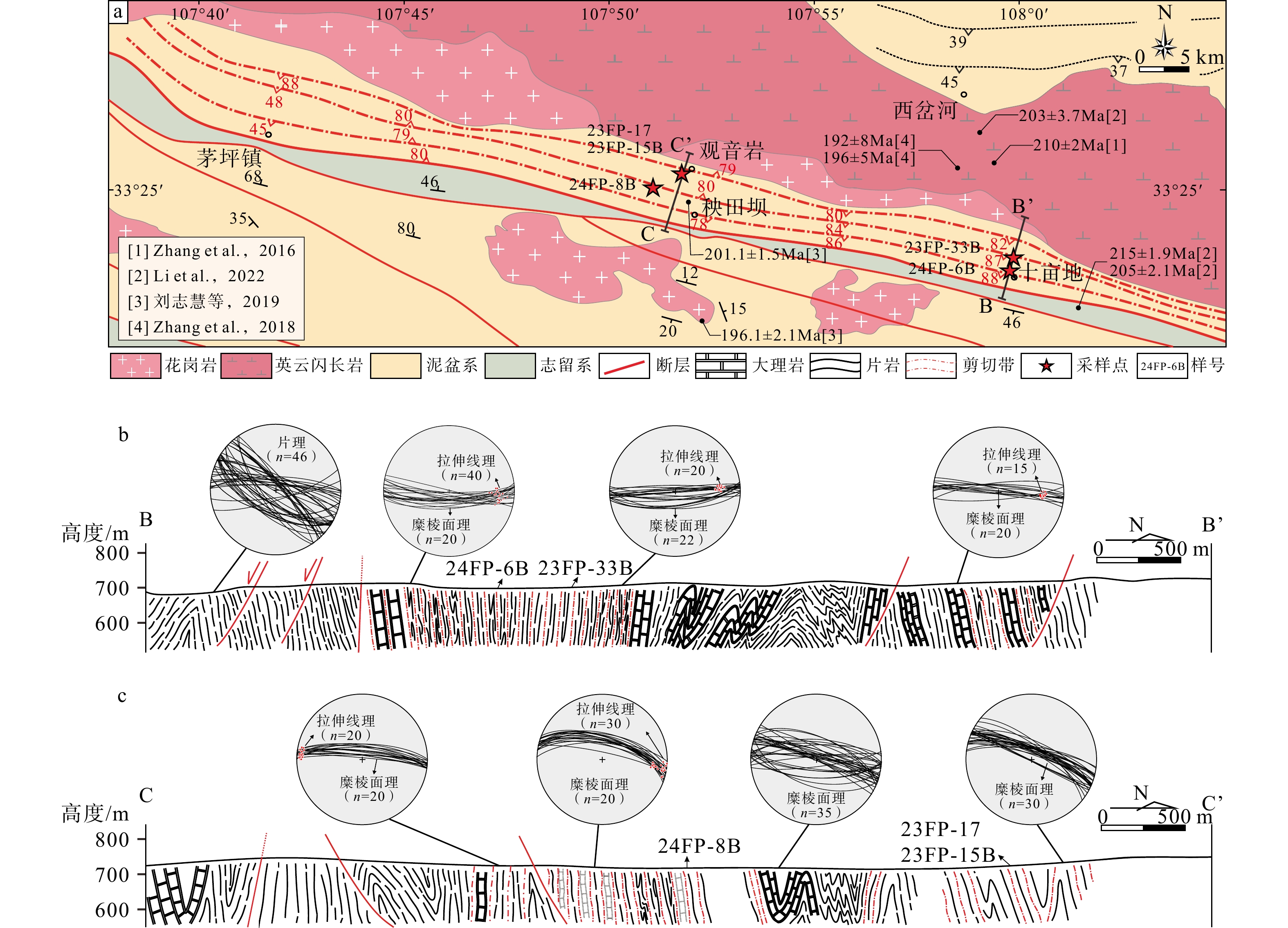
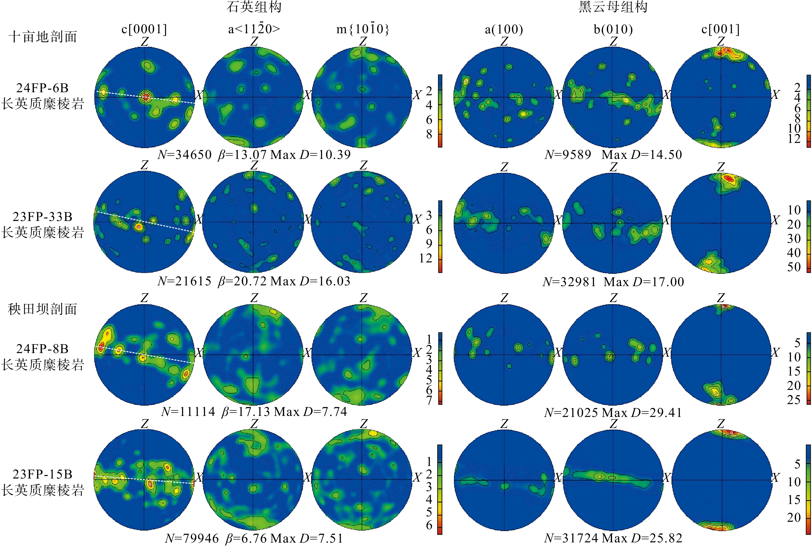
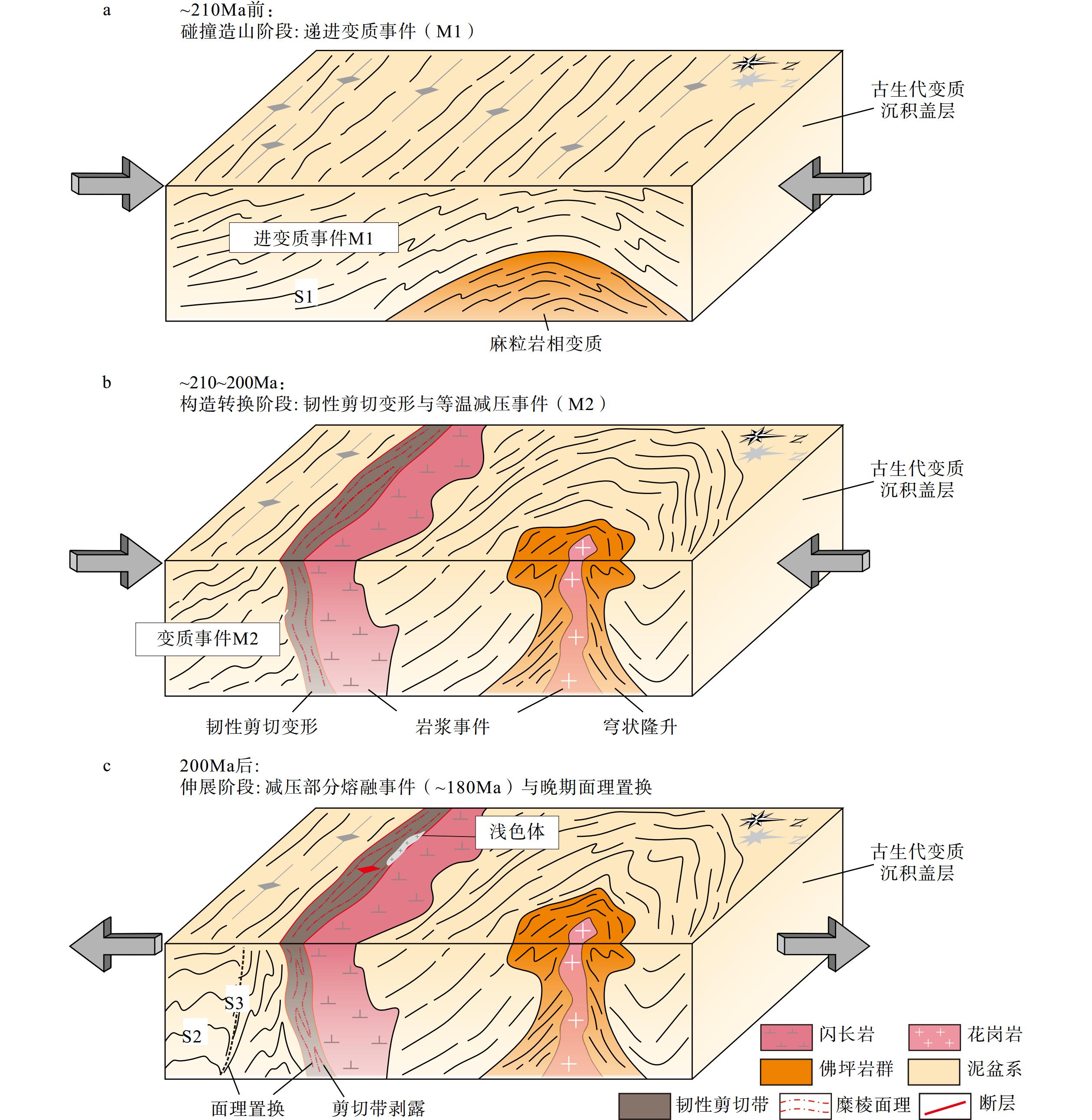
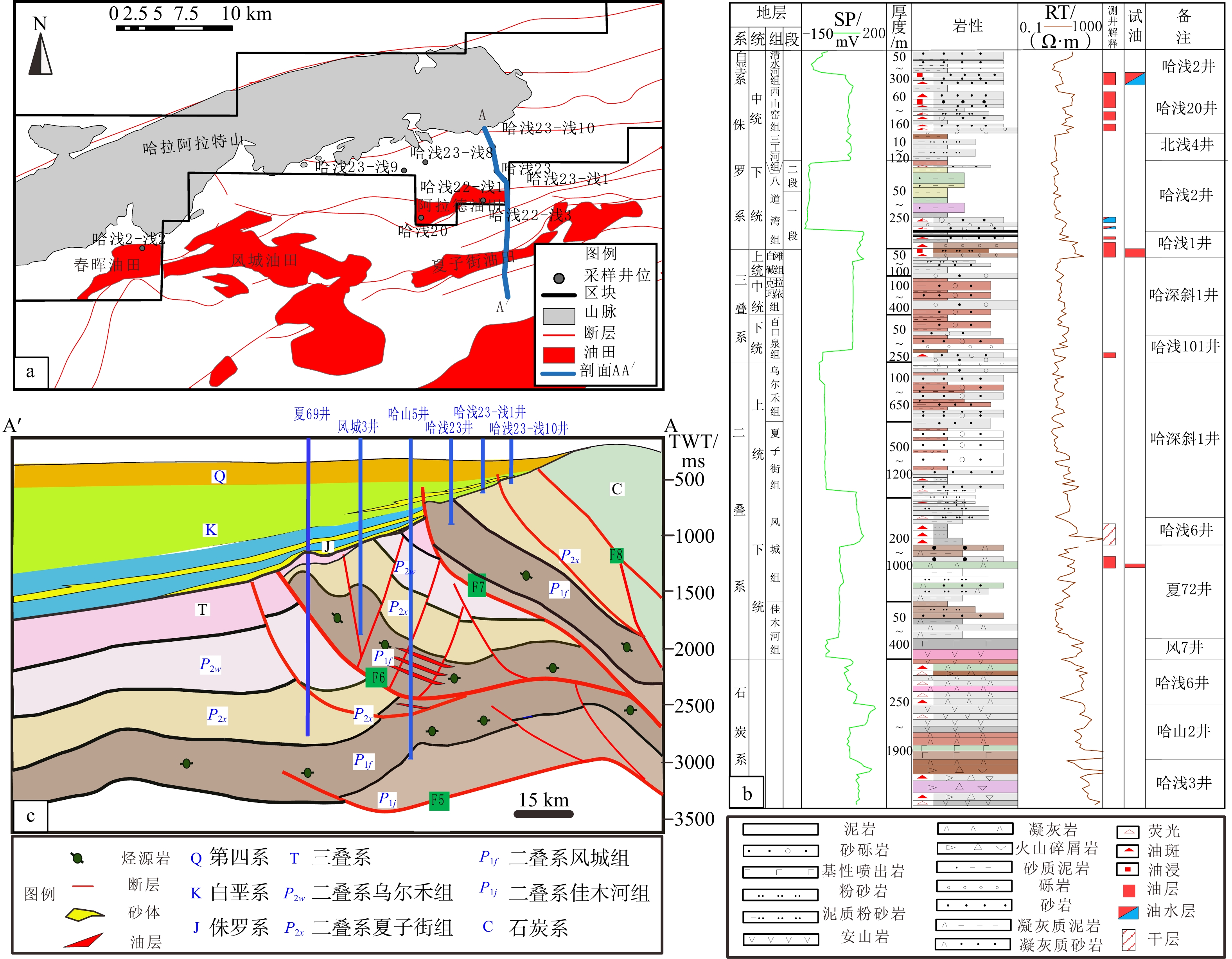
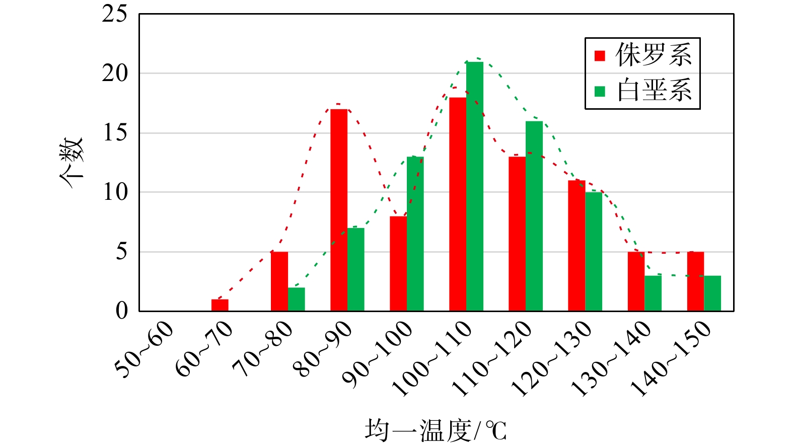
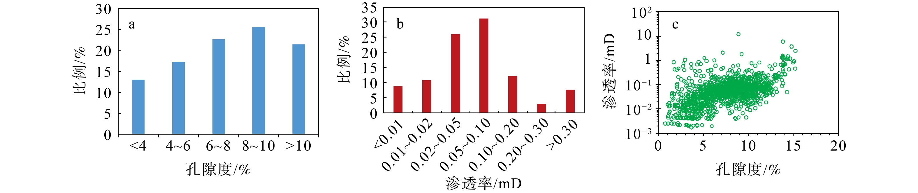
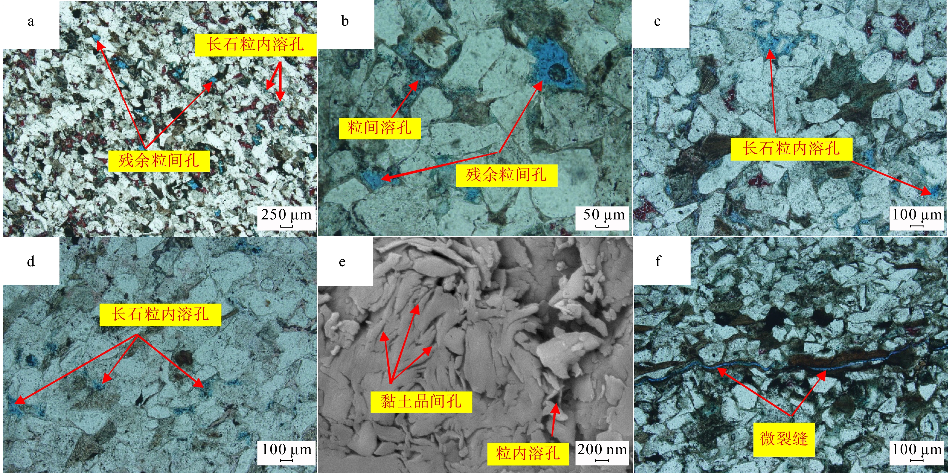
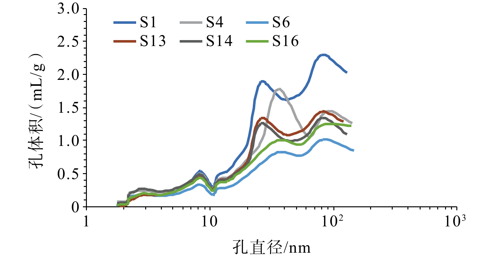
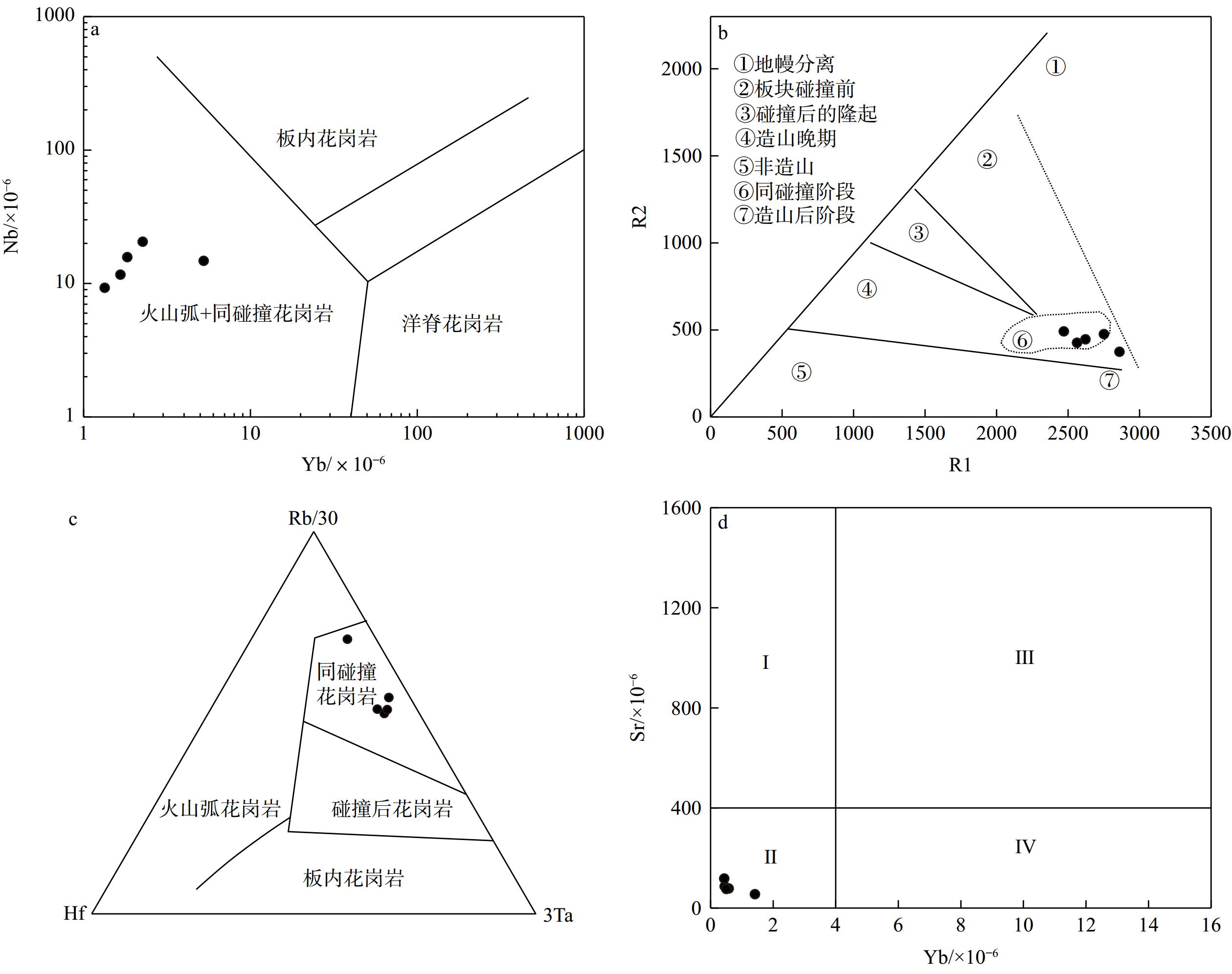
  Objective  The Hala’alat Mountain front-overthrust belt, renowned for its abundant hydrocarbon resources, is characterized by multi-layer oil-bearing systems and intricate source-reservoir relationships. Ultra-shallow strata have emerged as an important domain for resource evaluation and exploration in this region. However, the timing of hydrocarbon charging and adjustment processes and the complex accumulation mechanisms of ultra-shallow reservoirs remain inadequately understood, posing significant challenges for exploration planning and appraisal programs. This study endeavors to unravel the genetic characteristics, accumulation stages, and dynamic mechanisms of ultra-shallow reservoirs in the Hala’alat Mountain front, with the goals of enhancing the theoretical framework for hydrocarbon enrichment patterns in structurally complex zones and providing actionable insights for future exploration endeavors.   Methods  To achieve this objective, an integrated suite of analytical techniques was meticulously employed. Homogenization temperature measurements and salinity analysis of fluid inclusions were conducted to decipher thermal histories and fluid evolution. Quantitative grain fluorescence (QGF) analysis was utilized to track hydrocarbon migration pathways and accumulation dynamics. Calcite U–Pb geochronology provided precise temporal constraints for thermal events and hydrocarbon charging episodes. These methods were systematically applied to reservoir rock samples, enabling a comprehensive investigation of fluid inclusion characteristics, paleo-temperature evolution, and paleo-fluid interfaces. By constraining the thermal event chronology, we aimed to reconstruct the intricate hydrocarbon charging and adjustment processes that have shaped the current reservoir configuration.   Results  (1) The analysis revealed a diverse array of fluid inclusion types, with variations in fluorescence color and intensity indicative of multiple stages of hydrocarbon charging, each with a distinct maturity levels. The homogenization temperatures of aqueous inclusions exhibited two predominant intervals: 70–90°C and 100–130°C. These temperature ranges correspond to distinct thermal episodes, reflecting varying paleo-thermal regimes that influenced hydrocarbon maturation and migration. (2) The QGF profiles provided compelling evidence of dynamic hydrocarbon migration processes, showcasing multiple northward adjustments and accumulations over geological time scales. Notably, Jurassic strata displayed continuous charging characteristics, suggesting prolonged hydrocarbon influx, while Cretaceous reservoirs exhibited late-stage charging patterns, reflecting differential hydrocarbon charging histories across stratigraphic units. This stratigraphic variation in charging behavior offers crucial insights into the temporal and spatial distribution of hydrocarbons within the study area. (3) Calcite U–Pb dating identified two major thermal events at approximately 133 Ma (Early Cretaceous) and 73 Ma (Late Cretaceous). These events are temporally correlated with significant tectonic activities in the study area, including regional compression and fault reactivation. (4) The integration of homogenization temperatures, QGF data, and U–Pb ages revealed a two-phase hydrocarbon charging history. The first phase occurred during the Early Cretaceous (133 Ma), characterized by initial hydrocarbon accumulation driven by regional tectonic compression. The second phase took place during the Late Cretaceous (73 Ma), marked by structural adjustment and hydrocarbon redistribution. These phases were primarily driven by tectonic forces that facilitated vertical migration and redistribution of hydrocarbons into ultra-shallow traps, highlighting the interplay between tectonic events and hydrocarbon accumulation.   Conclusions  The ultra-shallow reservoirs in the Hala’alat front have undergone two critical accumulation phases: the Early Cretaceous initial charging phase and the Late Cretaceous structural adjustment phase. Hydrocarbon migration pathways were predominantly controlled by fault systems, which acted as migration carriers. The northward adjustments were facilitated by differential uplift and the caprock integrity, ensuring the preservation of hydrocarbons within the reservoirs. The coupling of fluid inclusion thermometry, QGF, and U–Pb dating has proven to be a robust and innovative toolkit for resolving multi-stage accumulation processes in complex thrust belts. This methodological integration not only enhances our understanding of hydrocarbon accumulation mechanisms but also provides a precise framework for identifying and dating these events. This study establishes a novel and comprehensive methodology for deciphering multi-phase hydrocarbon accumulation in tectonically active regions. [ Significance ] By offering critical insights into the timing, pathways, and driving mechanisms of hydrocarbon charging, this study provides a solid foundation for predicting ultra-shallow reservoir distributions in similar geological settings. The integration of chronostratigraphic and fluid dynamic analyses advances the theoretical understanding of hydrocarbon enrichment mechanisms in foreland thrust belts, with direct implications for exploration strategies and resource evaluation in analogous basins. Furthermore, the methodological framework developed in this study can be adapted and applied to other complex structural zones, potentially revolutionizing our approach of hydrocarbon exploration in challenging geological environments.
Study on the pore structure characteristics of interbedded shale oil and formation mechanisms of high-quality shale oil reservoirs in the Chang 7 Member, Yanchang Formation, Ansai Oilfield
LIU Yuhang, QIANG Wei, DANG Xin, LIU Bo, WEN Zhigang, TIAN Weichao, FAN Yunpeng
2025, 31(3): 506-521. doi: 10.12090/j.issn.1006-6616.2025011
Abstract (530) HTML (171) PDF (5691KB)(53)
Abstract:
  Objective  As a key producing horizon of the Ansai Oilfield in the Ordos Basin , the pore structure of Chang 7 Member of the Yanchang Formation directly controls reservoir quality, and consequently influences shale oil productivity. The Ansai Oilfield is facing depleted conventional resource and difficult reserve replacement, making shale oil reservoirs the main target for reserve growth. Therefore, characterizing the pore structure and constraining the genesis of different reservoirs is of great significance for oilfield exploration and development.   Methods  Targeting the interbedded shale oil reservoirs in the Chang 7 Member of the Ansai Oilfield, we carried out experiments including scanning electron microscopy, casting thin sections, low-temperature nitrogen adsorption, high-pressure mercury intrusion, and nuclear magnetic resonance, to identify the influence of pore size on the quality of the reservoirs, and to reveal the genesis of different reservoirs from the perspectives of depositional environment and diagenesis.   Results  The reservoir pores are predominantly composed of feldspar pores, residual intergranular pores, intergranular pores, clay intergranular pores, and a small number of microcracks. The feldspar pores are mainly micrometer-sized, while clay intergranular pores are dominantly nanometer-sized. The reservoir exhibits relatively high discharge pressures and low mercury injection saturation, with pore-throat radii predominantly at the nanometer scale. Most pores with diameters below 500 μm are open-type parallel plate-shaped and slit-shaped, with a small number of ink-bottle-type pores also developed. The pore sizes in the reservoir are predominantly below 300 μm, and as physical properties improve, the proportion of larger pores gradually increases.  Conclusion  The genesis of high-quality reservoirs can be categorized into two types. In the northeast, closer to the provenance area, strong hydrodynamic conditions lead to better sorting of rock particles, facilitating the development of chlorite coatings within the reservoir. These chlorite coatings can protect primary intergranular pores between particles, allowing more residual intergranular pores to be preserved after compaction, thus forming high-quality reservoirs. In contrast, the southwest area, being farther from the provenance, exhibits increasing water depth and weaker hydrodynamics. Due to its proximity to the source rock development zone, the reservoir is more susceptible to dissolution of organic acids from hydrocarbon source rocks, leading to the formation of numerous dissolution pores and the development of high-quality reservoirs. [ Significance ] The study can support the efficient exploration and development of shale reservoirs in the region.
Ore Field Structure & Mineralization
Analysis of ore-controlling structures and mineralization prediction of the Guocheng gold deposit in the northeastern margin of the Jiaolai Basin
CAO Peng, YANG Yaqi, ZHENG Chaoyang, WANG Wei, CHEN Yuanlin, LIU Jianzhong, ZHAO Xinghua
2025, 31(3): 522-538. doi: 10.12090/j.issn.1006-6616.2025015
Abstract (512) HTML (160) PDF (8475KB)(71)
Abstract:
  Objective  The Jiaodong Peninsula is the largest gold metallogenic province in China and represents the third-largest gold enrichment region globally. Most gold deposits in this area formed during the Early Cretaceous and are significantly controlled by NNE–NE trending normal faults. Notably, there are more limited gold reserves from the east of the Jiaodong Peninsula compared with those from the northwestern region. The Guocheng gold deposit with a medium size is located in the northeast of the Jiaolai Basin and develops complex fault structures. These gold ore bodies are mainly hosted within faults but show poor distribution regularity. Thus, it is necessary to determine the ore-controlling structures.   Methods  Through detailed surface and underground geological investigations and structural analysis, this study reveals that ore bodies are primarily controlled by a thrust-faulting system and are mainly hosted within marbles of the Jingshan Group and Muniushan granitic pluton.   Results  Precise structural analysis reveals that the study area had undergone at least three-stage tectonic activities. The first stage (D1) was driven by nearly NW–SE compression and formed NE-trending faults and a series of associated secondary faults. The second stage (D2) involved the NW–SE extension, which developed numerous NE-trending intermediate-basic dike swarms and resulted in the development of the Tudui faults and extensional reactivation of NE-trending faults. During the third stage (D3), the nearly NE-SW compression formed some post-ore-formation structures, including new reverse faults and reactivated pre-existing structures.  Conclusion  This study identifies NE-trending faults as principal ore-controlling structures, and proposes the coupling relationships between ore-bearing faults and the Guocheng and Houkuangdong faults. These main ore-bearing structures belong to the tensional-shear secondary faults in the footwalls of the Guocheng and Houkuangdong faults. The conclusion predicts that there are potential ore bodies in the footwall of the Houkuangdong Fault, which is also further confirmed by the drilling project. [Significance] Although the Guocheng gold deposit was also formed in the Early Cretaceous, the ore-controlling structures in this region are obviously different from the northwestern of the Jiaodong Peninsula, suggesting the heterogeneity of extension deformation in the Jiaodong Peninsula during the mineralization stage. Therefore, the thrust-faulting system may be one of the key ore-controlling structures in the east of the Jiaodong Peninsula.
Fundamental Geology & Regional Geology
Genesis of the gneissic biotite granite in Lanhe, northern Guangdong: Constraints from zircon U–Pb geochronology, Hf isotopes, and geochemistry
WANG Haiyang, ZHONG Fujun, PAN Jiayong, XIA Fei, CHEN Zhengle, LI Wenli, LIU Jungang, SUN Yue, YAN Jie, QI Jiaming
2025, 31(3): 539-556. doi: 10.12090/j.issn.1006-6616.2024137
Abstract (689) HTML (136) PDF (2278KB)(44)
Abstract:
  Objective  The Lanhe pluton in northern Guangdong is located at the southeastern margin of the Zhuguangshan Complex and is primarily composed of gneissic biotite granite; its petrogenesis has not yet been determined.   Methods  This study applied LA–ICP–MS zircon U–Pb geochronology, whole-rock geochemistry, and zircon Hf isotope analyses to the Lanhe gneissic biotite granite.   Results  U–Pb dating indicates that the emplacement age of the Lanhe gneissic biotite granite is 427 ± 2 Ma, representing a product of the Caledonian magmatic activity. The geochemical characteristics show that the granite has SiO2 contents ranging from 71.53% to 75.41%, high total alkali contents (K2O + Na2O = 7.57%–8.23%), and high A/CNK values (1.00–1.06). It is enriched in Rb, Th, U, and K, but depleted in Ba, Y, Nb, Ta, Sr, and Yb. The LREE/HREE ratios range from 9.49 to 28.15, with significant Eu negative anomalies (δEu = 0.21–0.76). The zircon εHf(t) values of the samples are all negative (–11.8 to –5.2), with corresponding tDM2 values of 1806–2129 Ma.   Conclusion  Based on the geochemical and isotopic characteristics, the Lanhe gneissic biotite granite is identified as a highly fractionated I-type granite, primarily formed by partial melting of crustal metasedimentary rocks, including metagraywacke and metapelite. It is likely a product of the multi-stage reworking of the Paleoproterozoic basement during the Neoproterozoic to Early Paleozoic. The comprehensive study suggests that the Lanhe gneissic biotite granite formed in a syn-collisional tectonic setting during the Early Paleozoic in South China. [ Significance ] Integrated with the Zhuguang magmatic system and regional geological data, the Lanhe pluton likely represents a product of the transition from compressional thickening to post-collisional extension during the Caledonian Orogeny in South China. This transition may have been associated with intracontinental tectonic reorganization or external subduction–collision processes.