2025 Vol. 31, No. 4

Cover Page
Cover Page
2025, 31(4)
Abstract (142) PDF (1562KB)(33)
Abstract:
Contents
Contents
2025, 31(4): 1-2.
Abstract (126) HTML (98) PDF (427KB)(22)
Abstract:
Special Section Dedicated to the 30th Anniversary
Chronological, geochemical characteristics and tectonic evolution significance of the Sanyan eclogites in the Jinsha River suture zone, eastern Xizang
TANG Yuan, LI Yiduo, WANG Dongbing, HAN Mingming, LI Xin, LUO Liang
2025, 31(4): 557-575. doi: 10.12090/j.issn.1006-6616.2025053
Abstract (417) HTML (126) PDF (4455KB)(105)
Abstract:
  Objective  As a key component of the eastern Tethys tectonic domain, the Jinsha River–Ailao Mountain suture zone is widely recognized as a Paleo-Tethys orogenic belt. However, due to the lack of metamorphic studies on high-pressure/ultra-high-pressure rocks, the subduction-to-closure process of the oceanic crust and the subsequent collisional orogenic evolution remain poorly constrained.   Methods  Systematic field surveys, petrographic observations, zircon U–Pb dating, and whole-rock major and trace element analyses were carried out on the newly discovered eclogites in the Sanyan area of the Jinsha River suture zone in eastern Xizang (Tibet). Based on the degree of retrogressive metamorphism, major mineral assemblages, and textural features, the Sanyan eclogites are classified into four types: garnet–albite–actinolite schist, garnet–actinolite, garnet–amphibolite, and eclogite.   Results  Zircon U–Pb dating of two eclogite samples yields 206Pb/238U ages of 247±2 Ma and 246±1 Ma, respectively. These zircons feature low Th/U ratios, extremely low content of Nb, Ta, and HREE, and no obvious negative Eu anomalies. Therefore, the genesis of the zircons should be eclogite-facies metamorphism, with the ~246 Ma age representing the timing of eclogite-facies metamorphism.   Conclusion  The whole-rock major element analysis of 12 samples shows that the protoliths are picritic basalt–basalt, and the trace element characteristics reveal diverse tectonic settings of the protoliths, including ocean island basalt (OIB), normal mid-ocean ridge basalt (N-MORB), and enriched mid-ocean ridge basalt (E-MORB), suggesting that the Sanyan eclogites were mainly formed by subduction of Paleo-Tethys oceanic crust materials (ocean islands and mid-ocean ridge basalts).   Significance  Combining the previously obtained zircon U–Pb ages of eclogites and the Ar–Ar plateau ages of phengites, the complete closure of the Jinsha River Paleo-Tethys Ocean in the early Middle Triassic (T21) is further constrained.
Correlation of detrital zircon ages among the Nanpanjiang basin, the Babu–Cao Bang tectonic belt, and the Northern Vietnam terrane: Tectonic implications
XIA Lei, XIA Wenjing, WEI Wei, SONG Chao, WANG Yin, LIU Fei
2025, 31(4): 576-588. doi: 10.12090/j.issn.1006-6616.2025068
Abstract (430) HTML (120) PDF (1571KB)(53)
Abstract:
  Objective  During the opening and closing of the Paleo-Tethys ocean, multiple continental blocks rifted from the northern margin of Gondwana, drifted northward, and eventually merged with the southern boundary of the Asian continent, forming multiple serpentinite belts. As part of the Paleo-Tethys orogenic belt, the Indosinian orogenic belt records the evolution history of the Paleo-Tethys ocean; however, key scientific issues, such as the location of the ocean basin and the subduction polarity, remain controversial. The keys to addressing these questions lie in defining the structural characteristics of the Babu–Cao Bang tectonic belt along the Sino-Vietnamese border and clarifying the tectonic affinity of the North Vietnam terrane. Specifically, it has to be determined, whether the Babu–Cao Bang tectonic belt represents a suture zone of a wide ocean basin, and whether the North Vietnam terrane is a component of the South China block or an independent micro-continental block.   Methods  In order to clarify these two questions, detrital zircon age data were collected from 31 sedimentary rocks in three tectonic units including the Nanpanjiang basin along the southwestern margin of the South China block, the Babu–Cao Bang tectonic belt, and the North Vietnam terrane. Furthermore, age data of inherited igneous zircon from the Song Chay massif in the North Vietnam terrane were obtained. The zircon age distribution histograms and probability curve peaks were compared within these three tectonic units.   Results  It was found that the age spectra of these samples mostly have peaks at 270–250 Ma, 460–420 Ma, and 1000–900 Ma. In addition, the age data are relatively concentrated around 1800 Ma and 2500 Ma, which reflects good consistency in the provenance of the three tectonic units.   Conclusion  Based on the stratigraphic correlation between the Nanpanjiang basin and the North Vietnam terrane from the late Paleozoic to the early Mesozoic and the faunal similarities during the same period, this study speculates that an extensional event led to the development of rifts, deep-water sediments, and even oceanic crust in the Babu–Cao Bang tectonic belt during the Permian. However, due to its limited extensional magnitude, this rift failed to evolve into a mature oceanic basin, preserving the tectonic connection between the North Vietnam terrane and the Nanpanjiang basin. The North Vietnam terrane is an important component of the South China block, and the open basin of the Paleo-Tethys ocean should have been located to the south of the North Vietnam terrane. [ Significance] This study provides evidence for the division of tectonic units in the Indosinian orogenic belt, and guides our understanding of Indosinian orogenic processes in the Sino-Vietnamese border area.
Apatite fission-track study of the volcanic rock area in southeast Zhejiang Province and its geological significance
FENG Hangjian, QIU Erkang, JIN Chong, LIN Dan, XU Xinghua, CAI Yao
2025, 31(4): 589-603. doi: 10.12090/j.issn.1006-6616.2025016
Abstract (609) HTML (109) PDF (3671KB)(98)
Abstract:
  Objective  As an essential component of the East Asian continental margin, the southeastern coastal region of China records a complex history of regional tectonics, magmatism, and geomorphological features associated with the subduction of the Paleo-Pacific/Pacific Plate. This region serves as an ideal window for studying ocean–continent interactions related to subduction zones. During the Cretaceous period, influenced by the rollback of the Paleo-Pacific Plate, a giant rhyolitic volcanic belt approximately 1200 km in length developed along the southeastern coast of China. Among the provinces in this region, Zhejiang hosts the largest preserved area of rhyolitic volcanic rocks and retains the most well-preserved volcanic structures. Previous studies have extensively investigated the geochronology, petrology, geochemistry, and metallogenesis of these rhyolitic volcanic rocks; however, their uplift and cooling history has been largely overlooked.   Methods  This study conducted apatite fission track dating and HeFTy thermal history modeling on the central facies intrusive rocks (quartz syenite, syenite and monzonite) of the calderas in the Yandang Mountain and Shenxianju areas.  Results  All the apatite fission track dates from the Yandang Mountain and Shenxianju areas show chi-squared probability P2) ≥ 0.05, indicating that the fission track dates of all specimens follow a Poisson distribution and belong to a single age population. Twenty of the total thirty-two specimens from the Yandang Mountain area yielded apatite fission track ages (pooled age and central age) between 40 Ma and 31 Ma, seven of the thirty-two specimens gave apatite fission track ages between 50 Ma to 41 Ma, with only five of the thirty-two specimens yielding apatite fission track ages ranging from 61 Ma to 51 Ma. For the Shenxianju area, the apatite fission track ages are predominantly (sixteen of the twenty-six specimens) distributed between 40 Ma and 31 Ma, with some specimens (eight of the twenty-six specimens) showing ages ranging from 50 Ma to 41 Ma and a few of them (two of the twenty-six specimens) yielding ages between 61 Ma and 51 Ma. Furthermore, the single-grain apatite fission track ages of the specimens from both the Yandang Mountain and Shenxianju areas show a unimodal distribution with a peak at 33 Ma. The mean confined track lengths of the specimens from the Yandang Mountain area vary between ~11.12 μm and ~14.09 μm with unimodal track length distributions. Specimens from the Shenxianju area yielded mean confined track lengths of ~11.11 to ~14.44 μm, also showing a unimodal track length distribution pattern. The mean Dpar values of specimens from the Yandang Mountain area range from 0.78 μm to 1.04 μm, while those from the Shenxianju area display mean Dpar values varying from 0.86 μm to 1.12 μm. The HeFTy thermal history modeling reveals a rapid exhumation and cooling event occurring from the early-Eocene to the earliest Oligocene for both the Yangdang Mountain (48 Ma to 33 Ma) and Shenxianju (52 Ma to 32 Ma) areas. The cooling rates of this event vary from ca. 8 ℃/Myr to 20 ℃/Myr for Yandang Mountain area and ca. 5 ℃/Myr to 16 ℃/Myr for Shenxianju area respectively.  Conclusion  Our new apatite fission track dating and HeFTy thermal history modeling results help identify an exhumation and cooling event in the Yangdang Mountain and Shenxianju areas during the early-Eocene to the earliest Oligocene epoch. Based on the results of this study and regional tectonic setting analysis, the early-Eocene to the earliest Oligocene exhumation and cooling event in the study areas is interpreted as being initially controlled by the subduction of the Izanagi-Pacific Plate ridge and later driven by the combined effects of the India-Eurasia continental collision and the rollback of the Pacific Plate.   Significance   This study provides important low-temperature thermal geochronological constraints on the Phanerozoic regional tectonic and geomorphological evolution of southeastern Zhejiang province.
Sedimentary characteristics of the Lower Cambrian Shuijingtuo Formation in the E’Xi trough and its petroleum geological significance
CHEN Ke, WANG Yuluo, LU Yanxin, LI Fei
2025, 31(4): 604-616. doi: 10.12090/j.issn.1006-6616.2025036
Abstract (376) HTML (93) PDF (1725KB)(55)
Abstract:
  Objective  The organic-rich shales of the Lower Cambrian in South China are characterized by significant thickness and high thermal maturity. Recent explorations have yielded industrial gas flows from the Lower Cambrian shales in the Middle Yangtze region. To further investigate the shale gas resource potential of the Lower Cambrian in South China, this study focuses on the Lower Cambrian Shuijingtuo Formation in the Middle Yangtze region.   Methods  Through an integrated analysis of outcrop observations and drilling data, we analyzed its sedimentary characteristics and processes. A third-order stratigraphic sequence framework for the Lower Cambrian shale was established, and a sedimentary model of the Early Cambrian E’Xi Trough in the Middle Yangtze region was constructed, clarifying exploration targets.  Results  The Lower Cambrian Shuijingtuo Formation in the Middle Yangtze region primarily consists of shallow-water and deep-water shelf facies, with shallow carbonate deposits at both the bottom and top. The Lower Cambrian organic-rich shales can be divided into five third-order sequences, which are correlatable with those in the Upper Yangtze region. The Shuijingtuo Formation formed during the filling stage of the E’xi Trough, primarily consisting of argillaceous clastic sedimentary rocks.   Conclusion  Organic-rich shales are distributed in deep-water facies, with two identified subsags within the E’xi Trough (the Enshi and Yichang–Changyang depressions) serving as key exploration targets. The Lower Cambrian Shuijingtuo Formation, together with the underlying Sinian Dengying and Doushantuo Formations, forms a "sandwich-like" conventional hydrocarbon assemblage, which is a priority area for future conventional oil and gas exploration in Western Hubei.
Tectonic System & Structural Geology
Late Paleozoic tectonic evolution of the Qinling Orogenic Belt: Constraints and insights from detrital zircon U–Pb geochronology in the Western Qinling
LI Chenghao, CHEN Zhengle, HUO Hailong, PAN Jiayong, WANG Yong, WANG Wenbao, WANG Shengang
2025, 31(4): 617-637. doi: 10.12090/j.issn.1006-6616.2025020
Abstract (675) HTML (182) PDF (3282KB)(120)
Abstract:
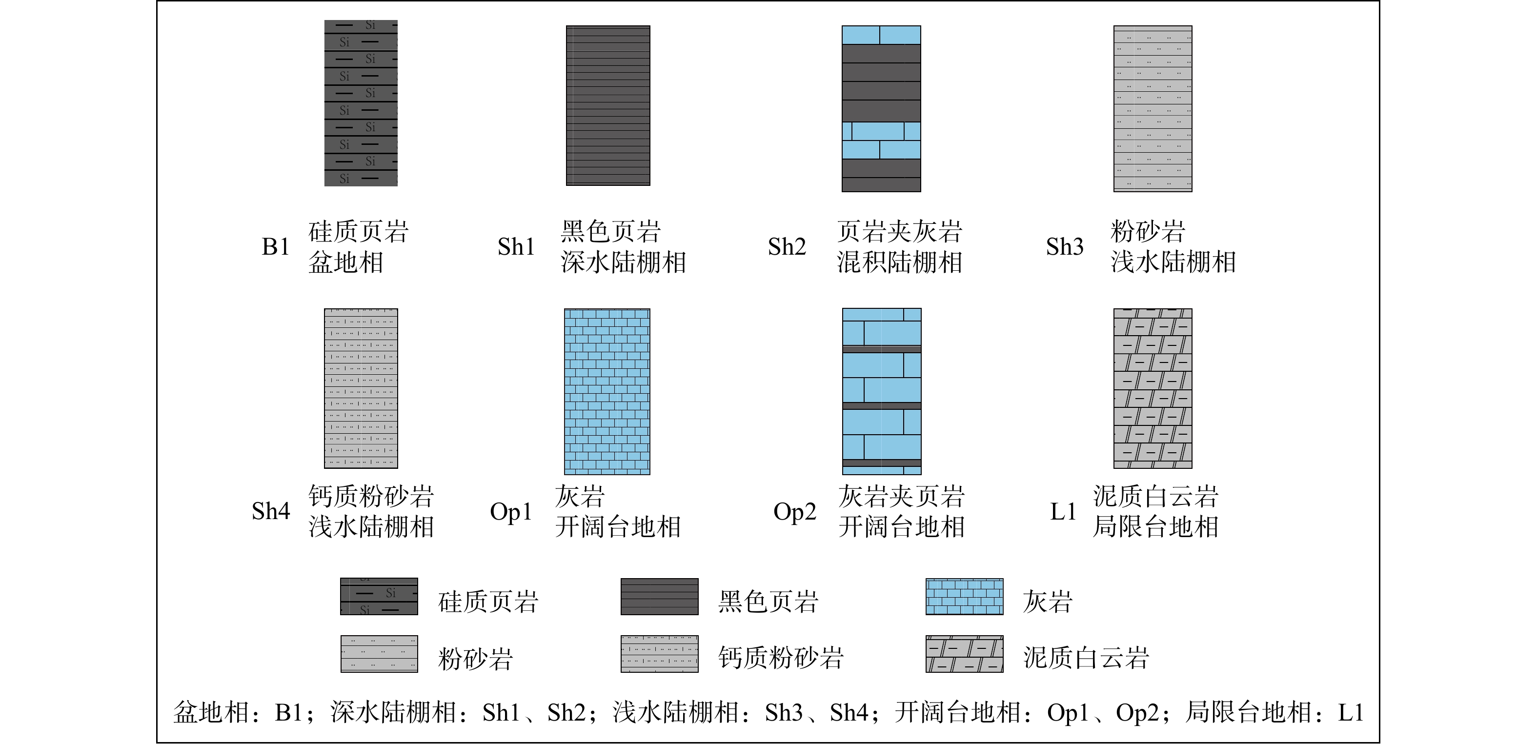
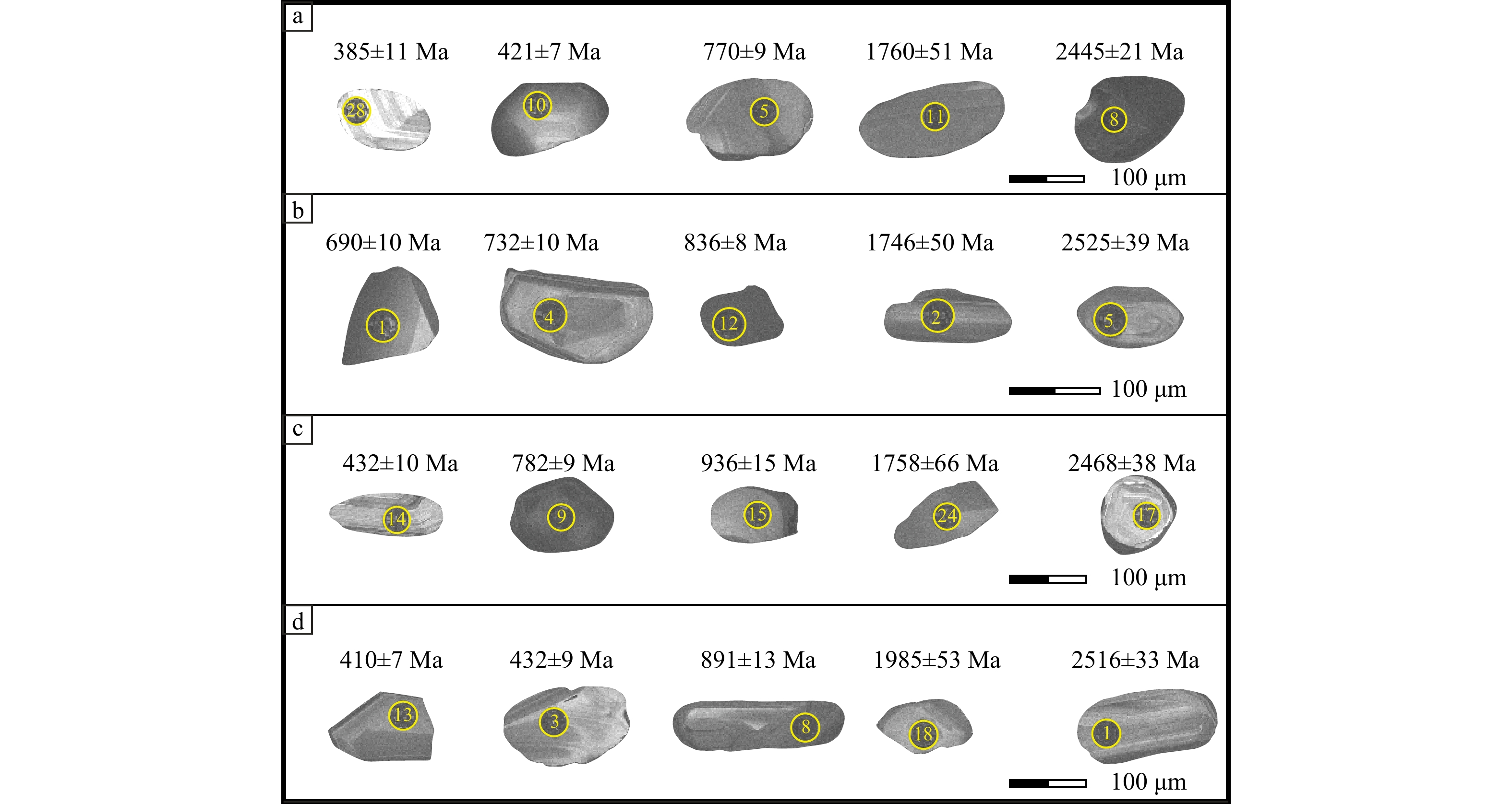
  Objective  The Qinling Orogenic Belt, positioned between the Yangtze and North China cratons, has undergone a multi-stage evolution from the Paleozoic to the Early Mesozoic, fully documenting the collisional orogenic history between both cratons. Substantial research achievements have been accumulated in fields such as provenance, lithogeochemistry, magmatic activity, and tectonics. However, key issues regarding the Early Paleozoic tectonic framework and Late Paleozoic ocean basin evolution of the Qinling Orogenic Belt remain controversial, primarily including the following aspects: The Shangdan Ocean may have closed during the Early Silurian, Carboniferous, or Indosinian periods; the subduction of the Mianlue Ocean may have initiated in the Early Carboniferous, Late Permian, end of the Late Permian, or later than the Early Triassic. The Zhaishang area in Minxian County, located within the Western Qinling Orogenic Belt, shows extensive Paleozoic strata and serves as a critical window for studying the tectonic evolution history of the Qinling Orogenic Belt.   Methods  Systematic sampling was conducted on the exposed Devonian, Carboniferous, and Permian strata in this area. The procedures included zircon single-mineral separation, target preparation, polishing, and cathodoluminescence (CL) imaging, followed by zircon U–Pb isotope analysis using LA–ICP–MS (Laser Ablation Inductively Coupled Plasma Mass Spectrometry). Based on these experimental results, detrital zircon U–Pb chronology was performed for the Devonian, Carboniferous, and Permian strata exposed in the Zhaishang area of Minxian County, Western Qinling, to constrain the Paleozoic tectonic evolution history and sedimentary processes of the Qinling Orogenic Belt.   Results  Results of detrital zircon U-Pb chronology show that the Shuanglanggou Formation of the Xihan Shui Group and the Badu Formation in the Zhaishang area of Minxian County exhibit similar detrital zircon age compositions. Detrital zircons from the Shuanglanggou Formation (Devonian Xihanshui Group) are characterized by the dominant age peak at 794 Ma, belonging to a Neoproterozoic age group (880~746 Ma), and the youngest age peak at 448 Ma. Detrital zircons from the Lower Carboniferous Badu Formation display Neoproterozoic age groups (901~750 Ma), the dominant age peak at 818 Ma, and the youngest age peak at 390 Ma. Detrital zircons from the middle member of the Lower Permian Shilidun Formation exhibit the dominant and likewise youngest age peak at 443 Ma, belonging to an Early Paleozoic age group (464~409 Ma).   Conclusion  Through comparing the relative probability distribution curves of detrital zircon U–Pb ages of the Devonian, Carboniferous, and Permian strata, as well as the correlation diagrams between detrital zircon age peaks and tectonic settings (including the northern Qinling Orogenic Belt, North China Craton, and Yangtze Craton as comparison targets), it is revealed that: The Devonian Shuanglanggou Formation and the Carboniferous Badu Formation in the Zhaishang area share a consistent detrital provenance, primarily the Yangtze Craton, followed by the northern Qinling Orogenic Belt; both tectonic settings are classified as rift basins. The detrital materials of the middle member of the Permian Shilidun Formation stem predominantly from the northern Qinling Orogenic Belt and correspond to a back-arc basin tectonic setting. By integrating the research results with the relative positions of the Qinling Orogenic Belt, the North China Craton, the Yangtze Craton, the Shangdan Ocean, and the Mianlue Ocean, it is concluded that the Zhaishang area in Minxian County was in a rift basin environment from the Late Devonian to the Early Carboniferous, and transitioned to a back-arc basin in the Early Permian. This transition marks the completion of the Mianlue Ocean’s evolution from oceanic expansion to subduction and demise. Additionally, the study constrains that: The Mianlue Ocean opened after the Early Carboniferous; the Shangdan Ocean closed before the Late Devonian. [ Significance ] This study provides new evidence and chronological constraints for the tectonic evolution of the Qinling Orogenic Belt, as well as the closure time of the Shangdan Ocean and the initial subduction time of the Mianlue Ocean, helping to reconstruct and restore the tectonic evolution process of the Qinling Orogenic Belt.
Crustal anatexis and ductile superimposition in the Culai Mountain region, western Shandong Province: Constraints on the Neoarchean tectonic framework of the eastern North China Craton
TANG Qiaoting, ZHANG Jian, ZHANG Shuhui, YIN Changqing, WU Qihang, ZHAO Chen, HE Mingtao, HUANG Wei
2025, 31(4): 638-656. doi: 10.12090/j.issn.1006-6616.2025043
Abstract (511) HTML (90) PDF (10747KB)(55)
Abstract:
  Objective  Western Shandong is located in the core area of the eastern North China Craton and represents a typical Archean basement exposure. It extends as an overall NW–SE trending linear belt. This area preserves not only multiple phases of magmatic records spanning the early to late Neoarchean but also abundant anatectic–rheological structures overprinted by ductile deformation fabrics. These features are of great significance for understanding the Neoarchean tectonic evolution of the North China Craton. The Culai Mountain region is one of the most promising areas for such geological studies. Situated in the core of the tectonic belt (Belt B) of western Shandong, it is characterized by well-developed anatexis and ductile deformation. This makes it an ideal location for investigating the spatial and temporal relationships between crustal anatexis and ductile deformation.   Methods  In this study, we selected a representative migmatite outcrop at the Huangshiya Village and conducted systematic field structural analyses, petrographic observations, and LA–ICP–MS zircon U–Pb geochronology.   Results  Field observations show that the structural lineaments in this region exhibit an overall NW–SE orientation. Numerous felsic melts developed within the amphibolites, mainly as bands along the foliation, with a few occurring in a network-like or disseminated pattern. Flow folds are well-developed. Petrographic observations demonstrate that quartz grains are distributed along the irregular, corroded boundaries of K-feldspar and plagioclase, containing small melt pockets, bead-like quartzs, and melt films. These features collectively indicate intense anatexis in the region. The newly generated melts reduced the overall rock strength, making it more susceptible to subsequent ductile deformation. Concurrently, NE–SW-oriented horizontal compressive stress further promoted NW–SE regional extension, consistent with the nearly vertical foliation and sub-horizontal mineral stretching lineations observed in the amphibolite. This suggests a deformation regime dominated by near-oblate strain. To constrain the timing of the regional deformation, we conducted LA-ICP-MS zircon U-Pb dating on representative pre-, syn-, and post-tectonic samples of the area. The results indicate that the residual amphibolite records a melt crystallization age of ~2503 Ma, representing the timing of the regional anatexis event. The syn-tectonic monzogranite yields a crystallization age of ~2497 Ma, reflecting a syn-tectonic magmatic event, while the undeformed pegmatite veins formed at ~2465 Ma, bracketing the regional ductile deformation at 2497-2465 Ma.   Conclusion  In summary, the western Shandong region experienced intense anatexis in the late Neoarchean, which was rapidly overprinted by near-oblate strain-dominated shortening deformation under NE–SW-oriented horizontal compressive stress. The anatexis further facilitated the development of NW–SE-directed ductile deformation. The superimposition of these two events ultimately shaped the structural pattern of the Neoarchean crust of the western Shandong region. [ Significance ] This study provides new constraints that improve the understanding of the Neoarchean tectonic framework and structural patterns of the western Shandong region.
Crustal Stress & Tectonic Stress Field
Study on creep characteristics of fractured rock masses in caved zones with different roof strengths
CAI Guanjun, WU Qiong, LIU Yunrong, LI Yidan
2025, 31(4): 657-672. doi: 10.12090/j.issn.1006-6616.2024135
Abstract (321) HTML (79) PDF (2232KB)(22)
Abstract:
  Objective  The caved zone in goaf areas is filled with fractured rock masses, and the strength of these fractured rock masses after collapse serves as a key factor causing differential long-term creep characteristics of the goaf. This study aims to comprehensively explore the creep characteristics of fractured rock masses with varying strengths.   Method  Grounded in the similarity theory, we selected analogous models of fractured rock masses representing three strength categories: soft rock, moderately hard rock, and hard rock. By integrating indoor step-loading creep tests with theoretical analysis, a systematic comparison of creep characteristics of fractured rock masses with varying strengths was carried out.   Results  The creep test results of three types of fractured rock masses reveal distinct deformation characteristics. Soft rock masses exhibit “sudden axial strain increments” under loads of 3 kN and 4 kN, while moderately hard rock masses display this phenomenon under a broader range of 3–5 kN. Evolution patterns of instantaneous, creep, and total strains show marked differences as the creep stress increases: soft rock masses demonstrate progressive decreases before stabilizing (instantaneous strain dropping from 0.084% at 1 kN to stable values beyond 4 kN); moderately hard rock masses exhibit an initial increase followed by subsequent decrease with peak strains occurring at different stresses (instantaneous at 2 kN, creep at 3 kN, total at 2 kN); and hard rock masses present more complex characteristics with instantaneous strain initially declining (0.033% to 0.020% in the 1–3 kN range) before rebounding slightly, while creep strain shows a triphasic pattern (increase–decrease–increase) peaking at 0.009% (3 kN) and total strain exhibits an overall trend of initial decrease followed by subsequent increase. Notably, all rock types share decreasing initial and steady-state creep rates with increasing stress. Compared with soft and hard rock masses, moderately hard rock masses experience more significant particle breakage and rearrangement during the creep process. This leads to an initial peak creep rate of 0.176 h−1 at 2 kN, exhibiting distinct peak characteristics. In contrast, hard rock masses exhibit rapid decay in creep rate and quick stabilization, reflecting their dense internal structure and strong interparticle contacts. These characteristics endow hard rock masses with rapid and stable mechanical response properties during the load-bearing process. The response differences of rock masses with varying strengths under the same load show positive correlation between rock strength and initial creep rate but an inverse relationship with steady-state rate. This indicates that while high-strength rocks respond more vigorously initially, they stabilize faster than low-strength rocks which sustain a longer duration of deformation.  Conclusion  Under incremenal loading, all three types of fractured rock masses exhibit decreasing trends in both initial and steady-state creep rates with increasing load, with particularly pronounced creep rate variations in the initial stage.   Significance  This study reveals creep characteristics of fractured rock masses of varying strength, providing a theoretical foundation for predicting long-term deformation of caved zones in goaf areas and developing geohazard prevention and control strategies.
Progress in the application of microseismic monitoring in the operation of underground gas storage
ZHOU Yuanjian, GAO Guangliang, ZHANG Hao, LI Cong, LI Chaofeng, LI Nan, YANG Yu, YANG Zhibin, HU Caiyun, SUN Dongsheng, ZHANG Chongyuan, LI Lei
2025, 31(4): 673-689. doi: 10.12090/j.issn.1006-6616.2025032
Abstract (521) HTML (117) PDF (10834KB)(47)
Abstract:
  Objective  Underground gas storage (UGS) systems are critical for ensuring the flexibility, reliability, and safety of natural gas supply. Microseismic monitoring has emerged as a key technology for assessing the integrity of caprock seals and evaluating dynamic geomechanical responses during gas injection and withdrawal operations. This study aims to systematically summarize the technical framework, implementation practices, and engineering benefits of microseismic monitoring in UGS applications.   Methods  The study integrates technical principles and field experiences from a range of UGS types, including depleted reservoirs, aquifers, and salt caverns. Monitoring approaches are categorized into surface, shallow-borehole, and deep-borehole networks. Key procedures including signal preprocessing, phase picking, event detection, location methods (arrival-time based and waveform stacking), and mechanism analysis are reviewed. Case studies from China (e.g., Hutubi, Tangshan M, and Jintan UGS) and Europe (e.g., Minerbio, Stenlille, Castor) are analyzed to demonstrate the effectiveness of microseismic monitoring under varying geological conditions.   Results  Quantitative findings from multiple UGS sites indicate that microseismic events typically range from ML −3.0 to 2.0, reflecting subtle stress perturbations. For instance, 229 events were recorded at the Hutubi UGS, exhibiting scattered distributions away from major faults and indicating effective caprock sealing. At the Jintan salt cavern UGS, 419 events within 23 days revealed dense clustering near cavern boundaries, enabling real-time evaluation of cavern stability. At the Tangshan M oilfield-based UGS, limited events were detected despite pressures exceeding 30 MPa, with analysis revealing insufficient sensitivity of surface and shallow monitoring arrays for 4-km-deep reservoirs. Comparative analysis of injection parameters and microseismicity demonstrated a stronger correlation with pressure variation than with injection volume. Additionally, the Castor UGS failure case in Spain, where delayed detection of fault reactivation led to M 4+ earthquakes and project termination, highlights the consequences of inadequate real-time monitoring.   Conclusion  Microseismic monitoring enables real-time assessment of stress evolution and caprock integrity, supporting risk mitigation and operational optimization throughout the UGS lifecycle. Gas and oil reservoir-type UGSs prioritize deep fault reactivation monitoring, while salt cavern UGSs focus on cavern wall deformation. Deep borehole sensors and dense arrays are essential for improving detection thresholds and depth accuracy. Future advancements should integrate fiber-optic sensing, machine learning algorithms, real-time data streaming, and interdisciplinary modeling to enhance early warning capability and ensure long-term operational safety of UGS systems.
Coulomb stress effects of the April 3, 2024 Hualien, Taiwan, China MS 7.3 earthquake on the surrounding faults and subsequent April 23, 2024 MS 6.2 and MS 6.3 earthquakes
GU Peiyuan, WAN Yongkui, SONG Zeyao, WANG Runyan, GUAN Zhaoxuan
2025, 31(4): 690-703. doi: 10.12090/j.issn.1006-6616.2024111
Abstract (528) HTML (127) PDF (10790KB)(43)
Abstract:
  Objective  To determine the rupture mode of the MS 7.3 earthquake in Hualien, Taiwan, China on April 3, 2024 and its triggering effect on subsequent seismic events in the surrounding area, the co-seismic displacement field and the induced areal strain response were analyzed by inverting the geometric structure and sliding characteristics of the seismogenic fault. The static Coulomb Failure Stress (CFS) triggering effect of the main earthquake event on the two MS 6.2 and MS 6.3 earthquakes that occurred on April 23, 2024 was evaluated to clarify the promoting effect of this earthquake on the seismic activity and its influence on the stress field of the adjacent area.   Methods  The two possible seismogenic nodes of the main earthquake and its subsequent earthquakes are determined by using the method of "focal mechanism solution". Based on the homogeneous elastic half-space theoretical model, the co-seismic displacement field and areal strain field under seismic action are established. The co-seismic displacement field results of the vertical fault direction of the main shock are analyzed and its sliding characteristics are determined. The CFS variation of the main shock in subsequent seismic events is calculated and its promoting effect on subsequent earthquakes is evaluated. The method of facet clustering is adopted to determine the seismogenic fault plane of the earthquake event. The stress field of the study area is projected onto the seismogenic fault plane and the causes of its occurrence are analyzed.   Results  A co-seismic displacement analysis of the April 3, 2024 MS 7.3 Hualien earthquake in eastern Taiwan reveals distinct patterns in both horizontal and vertical displacement fields, consistent with a reverse fault mechanism. Based on the focal mechanism solution, this seismic event is identified as a typical reverse fault earthquake, aligning with the tectonic compression between the Eurasian Plate and the Pacific Plate. The horizontal displacement field demonstrates a complex material flow pattern: substantial crustal materials converged towards the seismogenic fault along its southeastern and northwestern flanks, followed by outward migration in northeastern and southwestern directions. This kinematic pattern reflects the intense plate convergence where the Pacific Plate subducts westward beneath the Eurasian Plate along the eastern margin of Taiwan Island. Vertical displacement measurements show significant differential movement across the fault. The southeastern block (upper plate) experienced remarkable uplift reaching 48.4 cm, while the northwestern block (lower plate) underwent subsidence of up to 11.4 cm. This vertical displacement configuration, characteristic of thrust faulting, is further confirmed by cross-sectional observations perpendicular to the fault strike. The interface between the upper and lower plates exhibits sharp kinematic contrasts, with the upper plate displaying predominant upward motion components and the lower plate showing downward movements. Along-strike displacement reached approximately 22 cm, significantly exceeding the maximum perpendicular displacement of ~5 cm; this indicates thrust-dominated rupture with minor strike-slip components. The strain field distribution corresponds to a compressive belt parallel to the fault trace near the epicenter, flanked by extensional zones to the immediate east and west. Stress field analysis reveals significant shear stress concentrations (relative shear stress >0.7) and negative normal stresses on the fault planes of three major earthquakes in the sequence, consistent with the compressional regime generated by plate convergence. The westward subduction of the Pacific Plate beneath Taiwan Island creates optimal conditions for thrust faulting along the Longitudinal Valley Fault system, where accumulated shear stress ultimately exceeds the fault strength threshold. Notably, the Coulomb Failure Stress (CFS) calculations demonstrate that the April 3 mainshock significantly promoted subsequent seismic activity. The April 23 MS 6.3 and MS 6.2 events occurred in regions where the calculated CFS changes reached 0.020 MPa and 0.3 MPa, respectively, both exceeding the 0.01 MPa threshold for earthquake triggering. This earthquake sequence represents a normal release process of accumulated tectonic stress in the plate convergence zone. The spatial-temporal evolution of co-seismic deformation, strain redistribution, and stress interactions fully aligns with the regional tectonic framework dominated by the ongoing collision between the Eurasian and Pacific Plates.   Conclusion  Research shows that the MS 7.3 earthquake in Hualien, Taiwan, was caused by thrust faults. This earthquake event, along with the two subsequent MS 6.2 and MS 6.3 earthquake events that occurred on April 23, 2024, were all normal releases of local stress accumulation. Moreover, the CFS generated by the MS 7.3 earthquake in Hualien, Taiwan, has a significant impact on the surrounding seismic activities and has an obvious promoting effect on the occurrence of the subsequent two earthquakes. [ Significance] This study not only evaluates the impact of the MS 7.3 earthquake in Hualien, Taiwan, on subsequent earthquakes, but also provides a fundamental dataset for geodynamic studies in the region. Strengthening the capacity of earthquake monitoring and forecasting and disaster mitigation promotes the formulation of relevant policies and safeguards people's lives and properties.
Energy Resources Geology
Reservoir characteristics and diagenetic processes of the Benxi Formation in the East Yanchuan Block, Ordos Basin
GAO Yaning, ZHANG Shaohua, YU Miao, GAO Qiyu, GUO Haiyang, ZHANG Long
2025, 31(4): 704-719. doi: 10.12090/j.issn.1006-6616.2025054
Abstract (293) HTML (68) PDF (3264KB)(48)
Abstract:
  Objective  The Benxi Formation in the East Yanchuan Block of the southeastern Ordos Basin has emerged as a significant exploration target for tight gas reservoirs. Despite its strategic importance, the sandstone reservoirs in this interval are typically characterized by low porosity, poor permeability, strong heterogeneity, and complex diagenetic histories. These characteristics limit their development potential and make accurate reservoir prediction challenging. This study aims to thoroughly investigate the reservoir characteristics and diagenetic evolution of the Benxi Formation sandstones, with the goal of clarifying how multi-stage diagenetic processes control pore evolution and reservoir quality differentiation.   Methods  An integrated analytical approach was applied, including casting thin section petrography, scanning electron microscopy (SEM), and high-pressure mercury intrusion (HPMI). These techniques were used to examine pore types, mineral assemblages, diagenetic alterations, and pore-throat distributions, allowing for a detailed reconstruction of the diagenetic evolution and its influence on petrophysical properties.   Results  The study reveals: (1) The Benxi Formation sandstones have undergone a multi-stage diagenetic evolution involving three principal phases: mechanical compaction, cementation enhancement, and dissolution modification. Each stage had a distinct influence on the pore structure and reservoir performance. (2) Quartz-rich sandstones showed relatively high resistance to mechanical compaction but experienced substantial porosity loss during the middle diagenetic stage due to the pervasive precipitation of quartz and carbonate cements. This stage led to the formation of a rigid framework, where the intergranular pores were severely occluded, significantly reducing effective porosity and permeability. (3) Lithic quartz sandstones exhibited a much more favorable diagenetic trajectory. These rocks experienced strong dissolution of unstable components, such as feldspar and lithic fragments, resulting in the formation of secondary intragranular and intergranular pores. This process markedly improved pore connectivity and storage capacity, making this lithofacies the most favorable for tight gas accumulation. (4) Lithic sandstones suffered from intense early-stage compaction and cementation, which drastically reduced both primary and secondary porosity. As a result, these rocks exhibit extremely poor reservoir quality and are considered the least favorable reservoir type. (5) Based on the observed differences in diagenetic intensity and pore evolution characteristics, four distinct diagenetic facies types were identified.   Conclusion  (1) The reservoir quality of the Benxi Formation sandstones is primarily controlled by the intensity and sequence of compaction, cementation, and dissolution. (2) Different mineral compositions lead to divergent diagenetic pathways and contrasting pore evolution patterns. (3) Lithic quartz sandstones hold the highest potential due to extensive dissolution, while quartz sandstones are more susceptible to cementation. (4) Lithic sandstones, dominated by early-stage densification, represent poor-quality reservoirs. (5) The proposed four-type diagenetic facies framework effectively reflects the reservoir heterogeneity and offers practical criteria for facies-based reservoir prediction. [Significance] This study advances the understanding of diagenetic control on pore structure in tight sandstone reservoirs and provides a robust geological foundation for classifying and predicting reservoirs and targeting sweet spots in future exploration efforts.
Geo-hazards & Engineering Geology
Geomorphic signatures of reservoir–slope hazards triggered by the Baihetan Reservoir impoundment, lower Jinsha River, China
LI Lei, GU Zhenkui, FAN Hui, YAO Chuangchuang, YAO Xin, LI Renjiang, JIANG Shu, DAI Fuchu
2025, 31(4): 720-739. doi: 10.12090/j.issn.1006-6616.2025003
Abstract (531) HTML (100) PDF (5816KB)(61)
Abstract:
  Objective  Slope instability triggered by reservoir water-level fluctuations represents a prevalent geohazard in mountainous regions and canyons undergoing large-scale hydropower development. Since the 21st century, accelerated hydropower development has necessitated enhanced methodologies for identifying such specific-type geohazard potentials. In recent years, InSAR observations have largely addressed the challenge of identifying large-scale, multi-target deformation; however, due to limitations in real-time monitoring capabilities, this technique cannot detect latent hazards that have not yet manifested as deformations. Therefore, there is an urgent need to establish geomorphic signatures of reservoir-induced slope failures to improve hazard identification specificity. The large-scale impoundment of the Baihetan Reservoir since 2021 has triggered a series of slope instabilities, providing an exceptional opportunity to define the geomorphic signatures.   Methods  We integrated InSAR observations, geomorphic parameters, and optical imagery. Specifically, we utilize 228 ascending and 234 descending Sentinel-1A datasets (2020–2023) processed with DS-InSAR to identify deformed slopes triggered by reservoir water-level fluctuations.  Results  The results demonstrate the explanatory power of geomorphic parameters such as toe height, slope, aspect, and roughness in relation to disaster triggers. Furthermore, the analysis reveals correlations between lithological variations, slope structures, precipitation, and reservoir water-level fluctuations.  Conclusion  The strength of lithology, slope structure, and geomorphometric parameters in the Baihetan Reservoir area, along with their corresponding numerical ranges, form composite geomorphic signatures that can be used to identify hazards associated with reservoir water-level-induced slope instability early on. Additionally, we discovered that, beyond the effects of water-level fluctuations , precipitation events also play a significant role in triggering slope instability in the reservoir area, highlighting the importance of this factor as a driving force.  Significance  These insights significantly advance risk mitigation strategies for hydropower projects, facilitating optimal site selection and operation of hydropower stations, while providing a reference framework for assessing other slope instability mechanisms.
Fundamental Geology & Regional Geology
Deep magmatic processes of mafic layered intrusions in the Lala mining area, western Sichuan
SUN Junyi, LUO Zhaohua, CUI Jiawei
2025, 31(4): 740-754. doi: 10.12090/j.issn.1006-6616.2025028
Abstract (215) HTML (77) PDF (4033KB)(19)
Abstract:
  Objective  Previous studies have shown that many layered intrusions are formed by multiple pulsations of magma. However, little research has been done on whether the magma involved in the pulsation process comes from a single magma chamber or multiple magma chambers. Minerals, as products of magmatism, record the properties of magma chambers and deep magmatism.  Methods  Through the electron probe microanalysis technique (EPMA) on the hornblende and mica, combined with genetic analysis, mineral classification, and thermodynamic calculation, five different lithofacies zones of mafic layered intrusions in the western Sichuan LaLa mining area were studied.  Results  It shows that hornblende and mica of five different facies lithofacies zones formed in different stages of magmatism, with changes in the property of the magma chamber during crystallization.  Conclusion  There were at least two magma chambers with different properties in the deep layers during the formation of mafic layered intrusions. The layered intrusions were formed through multiple (4–5) magmatic pulsations, activated by fluid overpressure, which mobilized two magma chambers of differing compositions and depths.