2023 Vol. 29, No. 6

Cover Page
Cover Page
2023, 29(6): 1-1.
Abstract (148) PDF (1395KB)(57)
Abstract:
Contents
Contents
2023, 29(6): 1-2.
Abstract (132) HTML (73) PDF (443KB)(38)
Abstract:
Crustal Stress & Tectonic Stress Field
Considerations on the application of in-situ stress measurement and real-time monitoring in deep underground engineering in strong tectonic activity region
TAN Chengxuan, ZHANG Peng, WANG Jiming, FENG Chengjun, QI Bangshen, WANG Huiqing, LI Bin, CHEN Qunce, WU Manlu, SUN Weifeng, QIN Xianghui, ZHANG Chongyuan
2023, 29(6): 757-769. doi: 10.12090/j.issn.1006-6616.2023122
Abstract (367) HTML (89) PDF (1759KB)(70)
Abstract:

The concentration, complexity, and significant anisotropy of in-situ stress make it a pressing and challenging issue in engineering geology safety in strong tectonic activity areas. This paper firstly analyzes the application and existing problems of in-situ stress measurement in deep-buried underground engineering in strong tectonic activity areas. Then, it focuses on the application method, technology, and roles of real-time in-situ stress monitoring in deep underground engineering within tectonically active regions. Finally, it discusses the problems that need to be considered in the application of in-situ stress measurement and real-time monitoring. The results show that in the strong tectonic activity area, relying solely on limited deep hole in-situ stress measurements to determine overall stress design parameters for deep underground engineering is inadequate. A comprehensive study of the three-dimensional in-situ stress field is necessary to reveal its spatial distribution characteristics. Different in-situ stress design parameters should be used for different positions of the deep-buried underground project to avoid engineering waste or engineering damages caused by large or small in-situ stress design parameters. In the strong tectonic activity area, the disk core density is inversely proportional to the measured magnitude of the in-situ stress, and the depth range that has yet to form in the cake-shaped core often has the highest in-situ stress and the most concentrated stress, and the deep underground engineering should avoid this depth range. While a major earthquake or major engineering geological problem occurs, real-time monitoring of in-situ stress can dynamically reveal the relative change trend and evolution process of the in-situ stress magnitude of a specific structural site. It can calculate the absolute value of the in-situ stress state in different time domains during the real-time monitoring period without carrying out new absolute in-situ stress measurements. Regional crust stability and deep-buried engineering geological safety risks can be quickly evaluated, and quantitative in-situ stress design parameters and the stress-strain reserved threshold for preventing deformation and breaking can be provided for the damage repair of deep-buried engineering and the risk of fault activity can also be assessed. The research results will offer geological security for the planning, construction, and safe operation and maintenance of major projects in strong tectonic activity areas.

Study on the reconstruction of the paleo-tectonic stress field and its evolution in the Jinchuan mining district, Gansu Province, China
ZHAO Yuanfang, SHI Wei, ZHANG Yu
2023, 29(6): 770-785. doi: 10.12090/j.issn.1006-6616.2023161
Abstract (417) HTML (73) PDF (6873KB)(94)
Abstract:

The Jinchuan mining district has undergone a complex tectonic evolution history, and detailed analysis of the post-mineralization deformation characteristics and stress field evolution stages needs to be completed. This paper employs structural analysis methods to stage and correlate the faults in the bedrock of the Jinchuan mining district, determining the structural deformation sequence. It identifies four significant fault combinations in the region, including NE-trending thrust faults and NW-trending strike-slip faults, NE-trending strike-slip faults and NW-trending thrust faults, NW-trending normal faults, and NEE-trending strike-slip faults. The paleo-tectonic stress field of fault is reconstructed by using the lower hemisphere stereographic projection method on the base of studying faults and striations. Combining the paleo-tectonic stress field results with the regional tectonic evolution history, the study accurately defines the stress field evolution stages in the Jinchuan mining district after the mineralization period, which is crucial for understanding regional tectonic evolution and the development of new prospective areas. The results indicate that the Jinchuan mining district experienced four phases of paleo-tectonic stress field after the mineralization period, characterized by multi-stage compression or extension in different directions. These phases responds to a series of regional tectonic thermal events since the Mesozoic respectively: Phase I exhibits a NW–SE compression stress field during the early to middle Jurassic (J1-2); Phase II shows a NE–SW compression stress field during the late Jurassic (J3); Phase III reflects a NE–SW extensional stress field during the Early Cretaceous (K1); Phase IV represents a NE–SW compression stress field since the Late Cretaceous (K2).

Prediction and analysis on large deformation of surrounding rocks in the Muzhailing Tunnel of the Weiyuan–Wudu Expressway under high in-situ stress
FAN Yulu, CAO Jiawen, YU Shun, FENG Chengjun, ZHANG Peng, MENG Jing, QI Bangshen, WANG Huiqing
2023, 29(6): 786-800. doi: 10.12090/j.issn.1006-6616.2022110
Abstract (492) HTML (94) PDF (2934KB)(56)
Abstract:

This study aims to solve the significant deformation issue in the soft surrounding rocks under high in-situ stress encountered during the construction of the Muzhailing Tunnel on the Weiyuan–Wudu Expressway. We established a three-dimensional geological model to invert the in-situ stress field using ANSYS based on measured in-situ stress data in the engineering area. Then, we calculated and analyzed the deformation of the surrounding rocks by combining the inverted results with the Hoek deformation prediction formula. The result showed that the in-situ stress field in the engineering area was primarily controlled by faults, with secondary influences from rock strength and topography. In the intense tectonic deformation zone, horizontal principal stress values are generally lower than in the weak structural deformation zone. The relationship between the three principal stresses along the tunnel axis is SH>Sh>SV. The maximum horizontal principal stress in the intense tectonic deformation zone was the highest in the G8 section and the lowest in the G6 and G11 sections. In the weak structural deformation zone, horizontal principal stress gradually increases from the G12 section until it decreases due to reduced burial depth starting from the middle of the G14 section. The maximum horizontal principal stress orientation was generally in the NE direction, and the extruded structural belt between the faults was mostly deflected to the NEE –nearly EW direction. The deformation of the surrounding rocks was affected by rock mass strength and in-situ stress field, with rock mass strength playing a dominant role. The deformation of the surrounding rocks is mainly concentrated in the range of 20 to 80 cm, and the deformation levels are mainly moderate and intense.

Ore Field Structure & Mineralization
Deformation sequences and ore-controlling structures of the Chanziping–Daping gold mining area in Hunan Province, China
BAI Daoyuan, LI Bin, ZENG Guangqian, DONG Yujun, CAO Jinliang
2023, 29(6): 801-823. doi: 10.12090/j.issn.1006-6616.2023037
Abstract (278) HTML (84) PDF (8100KB)(58)
Abstract:

The Chanziping–Daping gold deposit area is located in the southwest section of the Xuefeng arc-shaped structural belt, with mainly NWW-NNW-trending and secondary NNE-trending Au veins. Existing studies proposed the NE-trending faults as the ore-passing and ore-bearing structures and the NW-trending faults as the ore-bearing structures. However, there is no clear and reliable understanding of the nature and age of ore-controlling faults. Given this, the authors carried out detailed field observation and analysis of surface outcrop structures and mineralization alteration, and then combined with regional structural characteristics, tectonic evolutions, and dating data, determined the deformation sequences and their ages in the Chanziping–Daping gold deposit area, and determined the types and attributes of ore-controlling structures. The study suggests that the study area experienced six main deformation events from early to late: Regional NWW compression during the late Silurian which resulted in the NNE-trending folds, slaty cleavages and brittle-ductile shear zones; Regional NNW compression in the late Middle Triassic which caused the formation of NWW-to-NW-trending dextral strike-slip faults and shear fractures, NS-trending sinistral shear fractures, NW- and NNE-trending conjugate shear fractures, NEE-trending thrust faults and superimposed folds; Regional NS compression in the early Late Triassic which led to the development of NW-to-NNW-trending dextral strike-slip faults and shear fractures, NNE-to-NE-trending sinistral shear fractures and faults, and NEE-trending sinistral kinks; Regional NWW-to-near EW-compression in the late Middle Jurassic which resulted in the NS-to-NNE-trending thrust faults, NW-to-NWW-trending sinistral shear fractures, NE-trending dextral thrust shear fracture, NNE-to-near NS-trending fracture cleavages, foliation folds and boudins; Regional NE compression in the middle-late Paleogene which led to the development of NNE-to-NS-trending dextral shear fractures and faults, NEE-trending sinistral shear fractures, NW-trending thrust faults and fracture cleavages; Regional NW compression during the late Paleogene to early Neogene which led to the formation of NE-trending thrust shear fractures and NWW-trending dextral shear fractures. The NNE-trending mineral veins in the study area formed in the late Silurian and the late Late Triassic, and the NWW-to-NNW-trending mineral veins formed in the late Late Triassic. The mineralization in the late Silurian was associated with the tectonic activation caused by the fault movement, and the mineralization in the late Late Triassic was related to large-scale granitic magmatism in the same period. The ore-passing structures are mainly the large NNE-trending faults, namely the brittle-ductile shear zones formed by NWW- compression in the late Silurian. The main ore-bearing structures are the NWW-to-NW-trending dextral strike-slip faults formed by NNW compression in the late Middle Triassic, NW-to-NNW-trending dextral strike-slip faults formed by NS compression in the early Late Triassic, with next NNE-trending brittle-ductile shear zones formed by NWW compression in the late Silurian.

Quaternary Geology & Environment
Geomorphic features of the Menyuan basin in the Qilian Mountains and its tectonic significance
LI Hongqiang, YUAN Daoyang, SU Qi, WEN Yameng, SU Ruihuan, SUN Hao, CHEN Yanwen, YU Jinchao, ZHANG Lijun
2023, 29(6): 824-841. doi: 10.12090/j.issn.1006-6616.2023123
Abstract (316) HTML (106) PDF (5295KB)(56)
Abstract:

The Qilian Mountains are situated on the northeastern margin of the Tibetan Plateau and serve as the leading edge of the plateau's northeastward expansion. The Menyuan Basin, characterized by typical basin landforms, provides valuable insights into the region's neotectonic activity and geomorphic evolution. As a representative mountain basin located in the central part of the Qilian Mountains, the Menyuan Basin's development pattern and geomorphic features are closely linked to tectonic activity. This study aims to investigate the variations in tectonic activity and their underlying causes along the north margin fault and different zones of the Menyuan Basin. To achieve this, 30 m resolution digital elevation model (DEM) data and ArcGIS spatial analysis technology were employed to extract the hypsometric integral (HI) and hypsometric integral curve (HC) of 15 rivers that traverse the northern edge of the basin. Subsequently, kriging interpolation was utilized to obtain the spatial distribution characteristics of HI within the basin. The findings reveal that HI values generally exhibit higher values on the western side and lower values on the eastern side of the Menyuan Basin, with the turning point (Laohugou) of the northern fault at the Menyuan Basin serving as the boundary. By combining the distribution of HI with field investigation results of active structures, it is observed that the eastern fault has extended into the basin's interior, giving rise to a series of active reverse fault–fold zones. This phenomenon may be attributed to changes in fault trends and the presence of northeastward faults. Additionally, a high HI anomaly is detected near Qingshizui Town in the basin's interior. Based on previous electromagnetic detection results, it is inferred that a buried fault exists within the basin. Furthermore, the study demonstrates that most rivers exhibit peak fluctuations in the stream length–gradient index (SL) at a specific position upstream of the main fault, indicating a strong correlation between the location of SL fluctuations and the position of the fault intersecting the river. In other words, tectonic activity can exert a significant influence on SL. Abnormal fluctuations near lithological transitions may suggest that local changes in lithology also impact the stream length-gradient index. The comprehensive analysis underscores the substantial differences in geomorphic development between the eastern and western sections of the northern edge of the Menyuan Basin, primarily controlled and influenced by the active structures in this region. Moreover, the aforementioned geomorphic parameters serve as sensitive indicators for evaluating tectonic activity.

Quantitative staging of alluvial fan geomorphic surfaces in arid areas based on SAR imagery: A case study of the Shule River alluvial fan in the western desert region of the Hexi Corridor
YANG Yongzhong, REN Junjie, LI Dongchen
2023, 29(6): 842-855. doi: 10.12090/j.issn.1006-6616.2023080
Abstract (190) HTML (69) PDF (6361KB)(13)
Abstract:

The alluvial fans and river terraces formed by river processes effectively record past tectonic activities, climate changes, and geomorphic evolution processes. Accurately dividing the alluvial fan into stages is the basis for the subsequent research. Previous researchers used L-band SAR backscatter coefficient values as a substitute parameter for geomorphic roughness to achieve quantitative zoning of geomorphic surfaces. However, these studies did not consider the impact of different time data sources on the geomorphic surface results. This study selects the Shule River alluvial fan as the research object. It determines the optimal data source by analyzing the posterior statistical indicators of multi-temporal L-band SAR data and evaluating atmospheric conditions. The maximum likelihood classification method is used to complete the classification of backscatter intensity values and achieve quantitative staging of the geomorphic surface. The results indicate that the posterior statistical indicators of staging can be used as the standard for selecting the best temporal image data to obtain better staging results. L-band HH monopolarization data provides better staging results, demonstrating advantages in distinguishing landforms of different ages compared to C-band data. Moreover, L-band data is more accessible and holds potential for automated staging. SAR image quality and staging results are closely related to imaging atmospheric conditions but show minimal seasonal dependence. Therefore, the study recommends prioritizing images with low surface water content during imaging, such as in high-evaporation intensity summer seasons. The proposed method for analyzing remote sensing data quality and staging landforms can be applied to rapidly and quantitatively stage large-scale alluvial fans in arid regions, providing valuable information for studies on tectonics and climate.

Evolution of sedimentary environment at the ZKA01 borehole in the north wing of the Yangtze River Delta since late Quaternary
LIU Xianguang, YANG Jinwei, JIANG Ren, LIANG Feigang, XIA Bin, WANG Ju, HU Li, SUN Fengrui, DONG Junlin
2023, 29(6): 856-868. doi: 10.12090/j.issn.1006-6616.2023025
Abstract (168) HTML (60) PDF (3677KB)(25)
Abstract:

The late Quaternary chronostratigraphic framework and marine transgression have long been research focal points in the Yangtze River Delta. The frequent channel oscillation and river incision in the Yangtze Delta have led to the frequent absence of complete stratigraphic records. Complete marine transgression records have yet to be discovered within the same borehole in this region. Based on lithostratigraphy, biostratigraphy, paleomagnetic chronology, and OSL dating studies of the ZKA01 borehole in the Dongtai area of the northern wing of the Yangtze River Delta region, the stratigraphic chronology framework since Marine Isotope Stage 5 (MIS5) was established. The ZKA01 borehole was found to have comprehensively recorded five marine transgression events in the Yangtze Delta region since late Pleistocene. The results indicate that the B/M boundary of the ZKA01 borehole is located at 108 m, and the M/G boundary is at 300.25 m. The boundary between the Middle and Upper Pleistocene is positioned at the bottom of the third marine transgression layer, precisely at 92.95 m. The boundary between the Upper Pleistocene and Holocene boundaries is located at the bottom of the first marine transgression layer discovered in the borehole, precisely at 16.65 m. The first three transgressions occurred during MIS5 (128–74 ka), of which MIS 5.1 had a larger scale, second only to the scale of the transgressions during the Holocene. The fourth transgression occurred during MIS3 (60–24 ka), equivalent in depth and age to the "II marine phase layer" of MIS3. The fifth transgression occurred during MIS1 (12 ka to present), depositing in a nearshore shallow marine environment, with the largest scale observed. Additionally, it was identified that the first transgression layer (MIS5) is approximately equivalent in burial depth across various regional boreholes, serving as a distinctive stratigraphic marker for stratigraphic division and comparative studies in the Yangtze River Delta. These research findings hold significant importance for Quaternary stratigraphic division and comparative analysis of sedimentary environments in the Yangtze River Delta.

Active Tectonics & Earthquake
General Geology & Regional Geology
Geochronology and petrogeochemical characteristics of U-bearing granites in the Dongshang deposit, northwestern Jiangxi, China and its geological significance
DANG Feipeng, LYU Chuan, TANG Xiangsheng, ZHANG Yong, XIAO Zhibin, LI Zhipeng, TANG Junyang, ZHANG Tao
2023, 29(6): 898-914. doi: 10.12090/j.issn.1006-6616.2023028
Abstract (244) HTML (75) PDF (4365KB)(27)
Abstract:

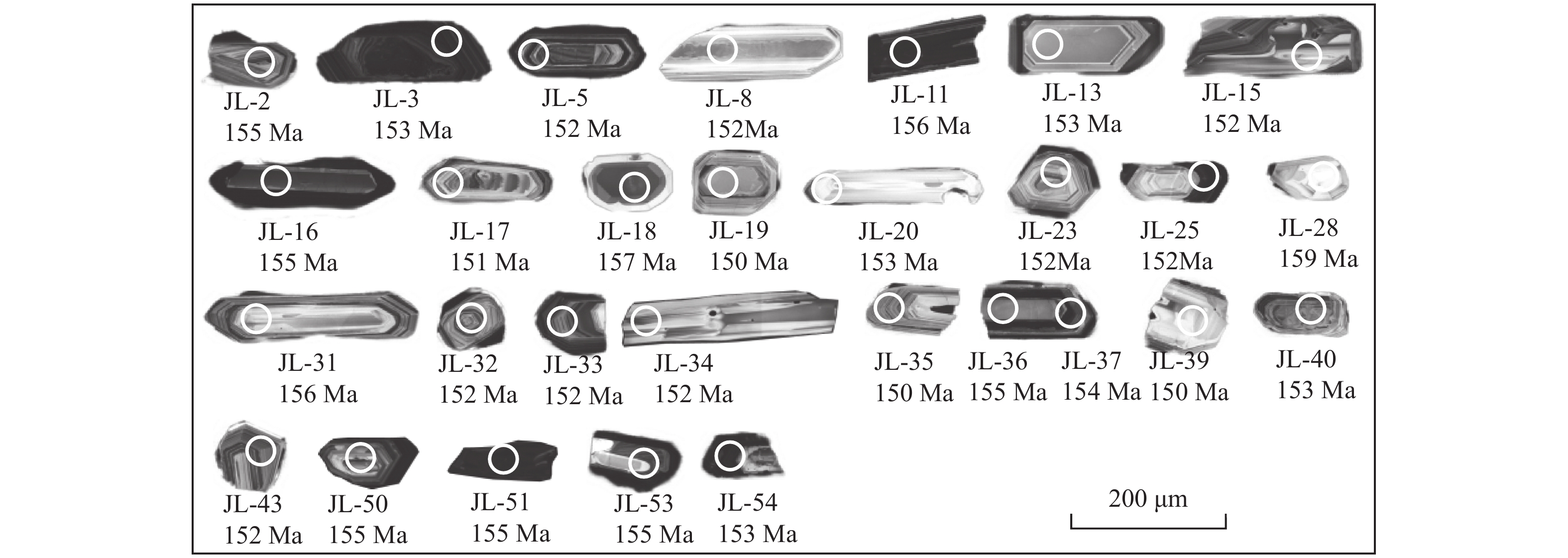
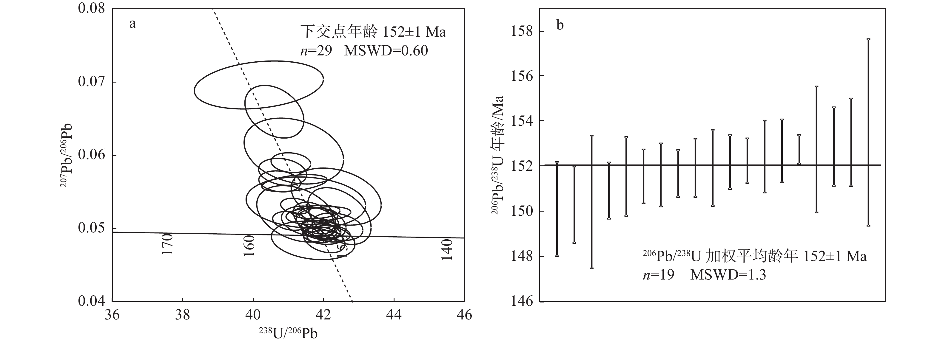
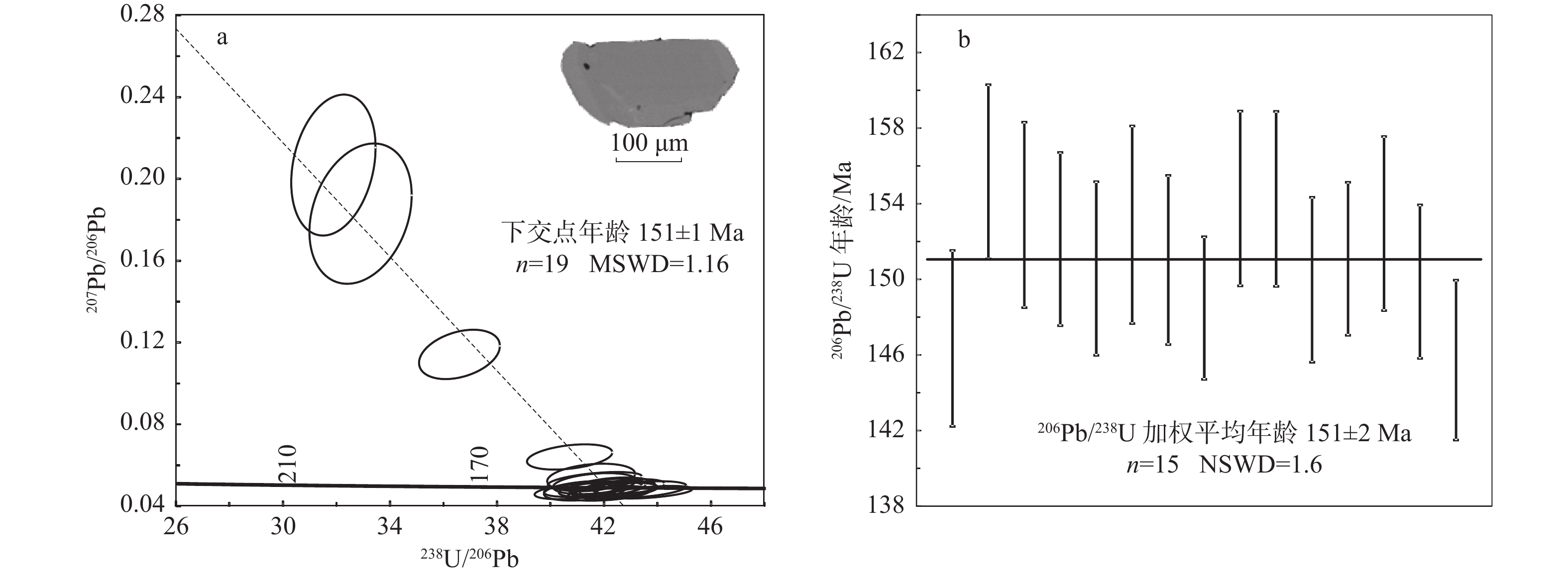
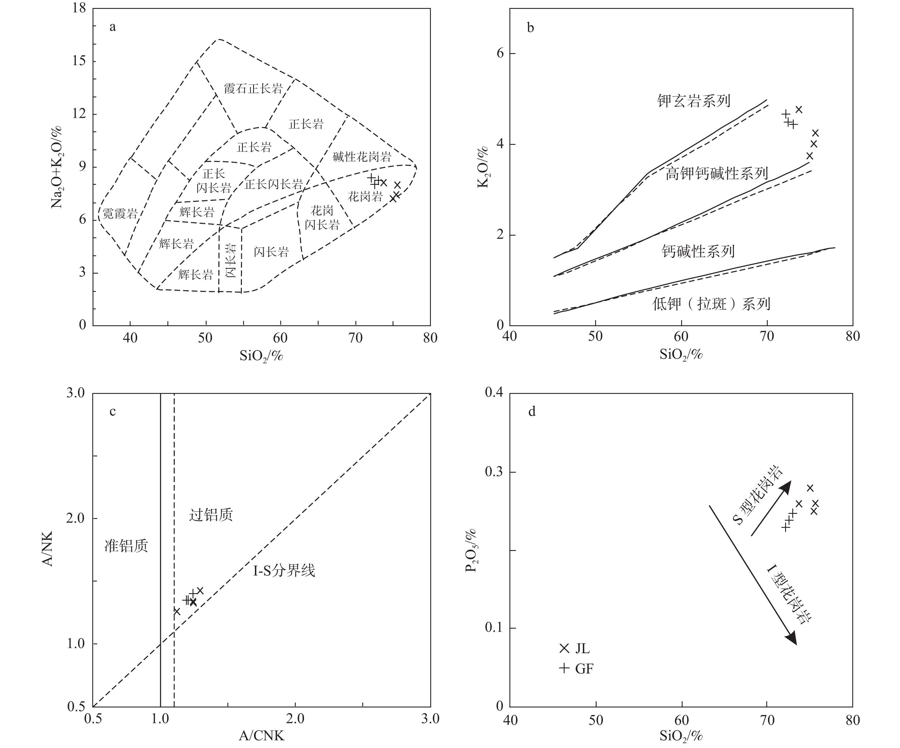
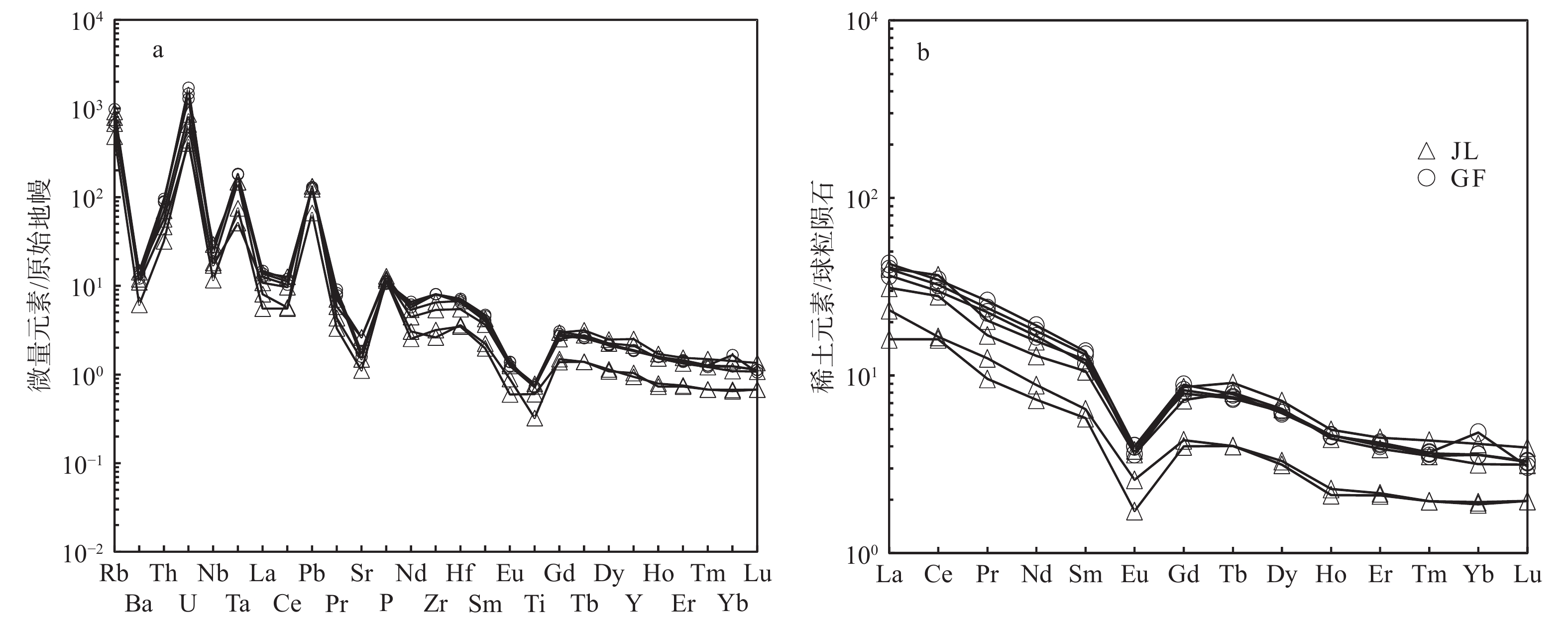
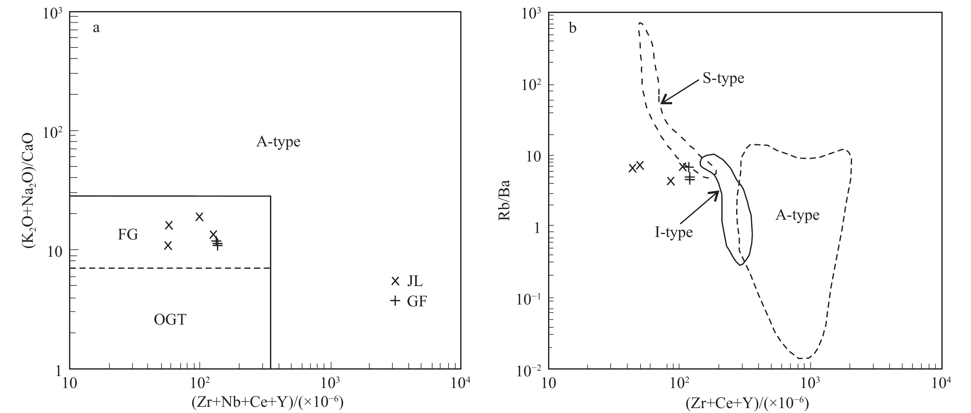
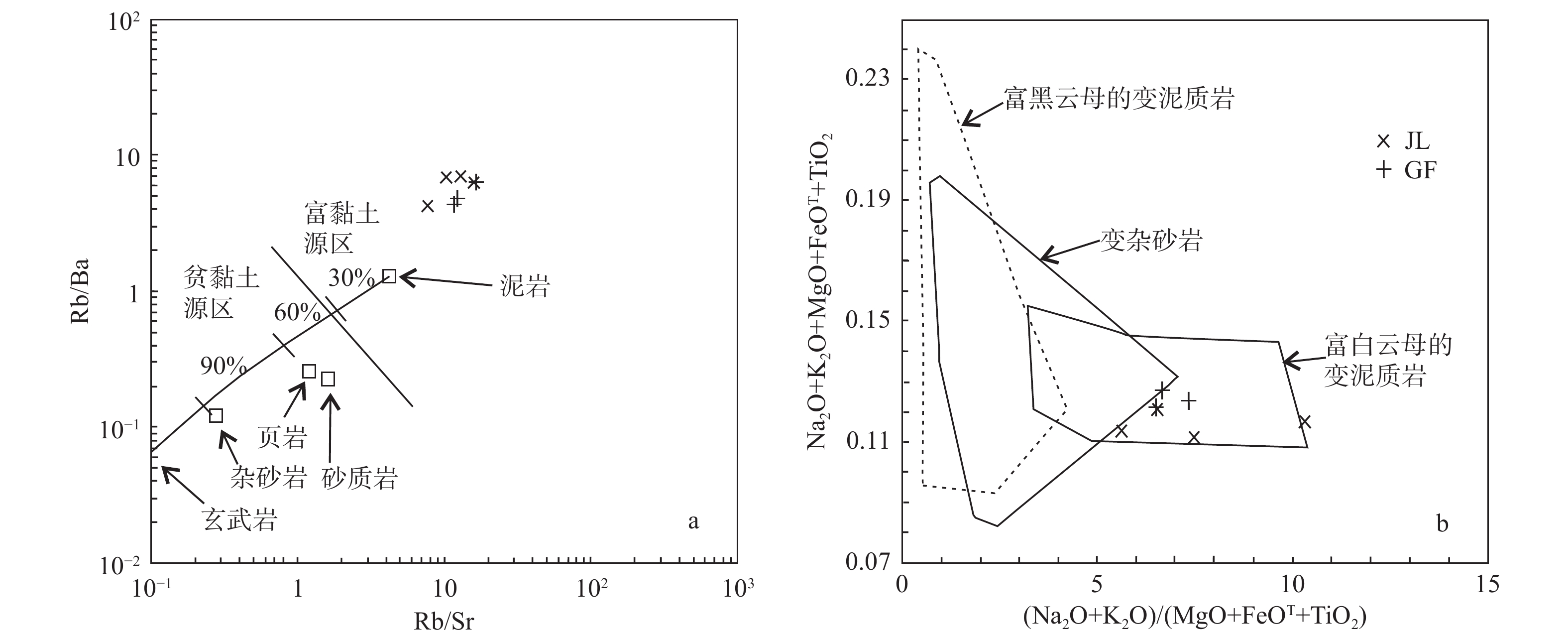
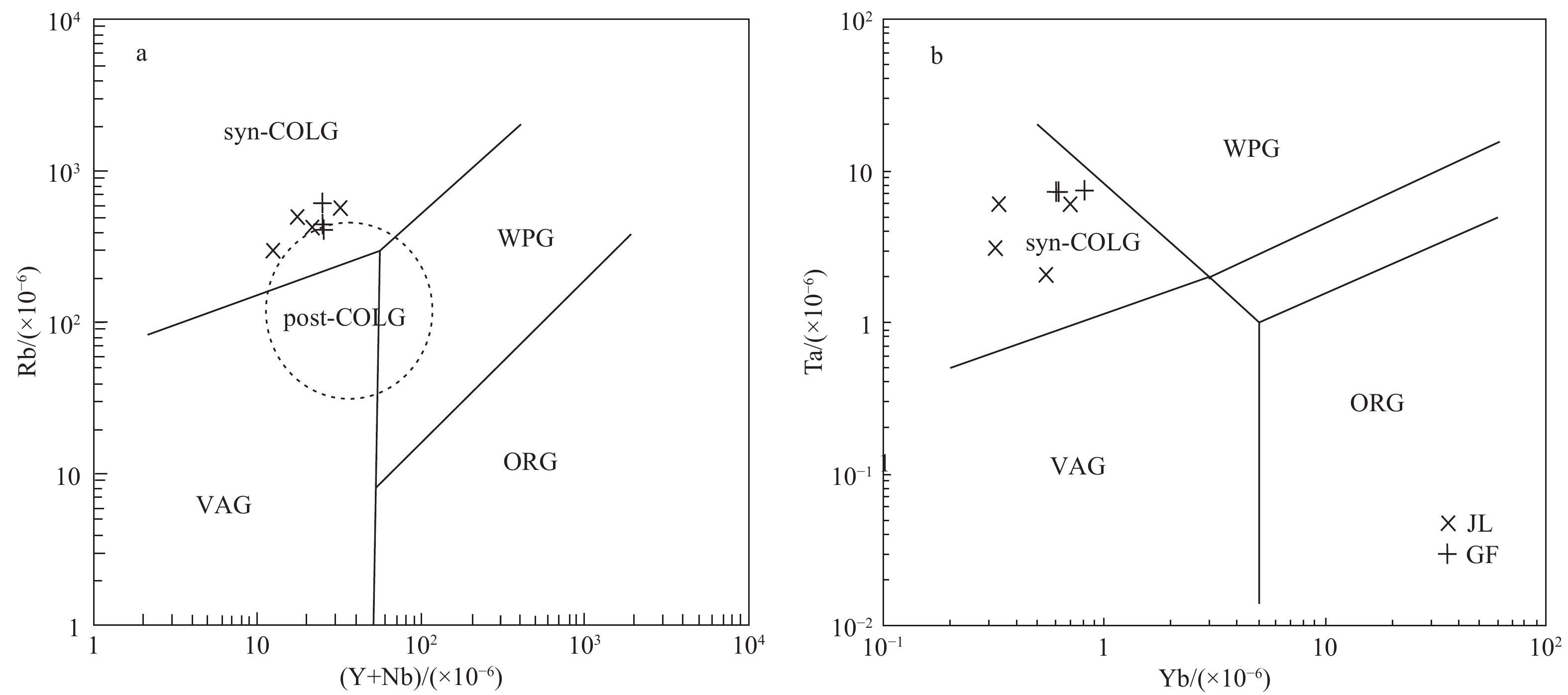
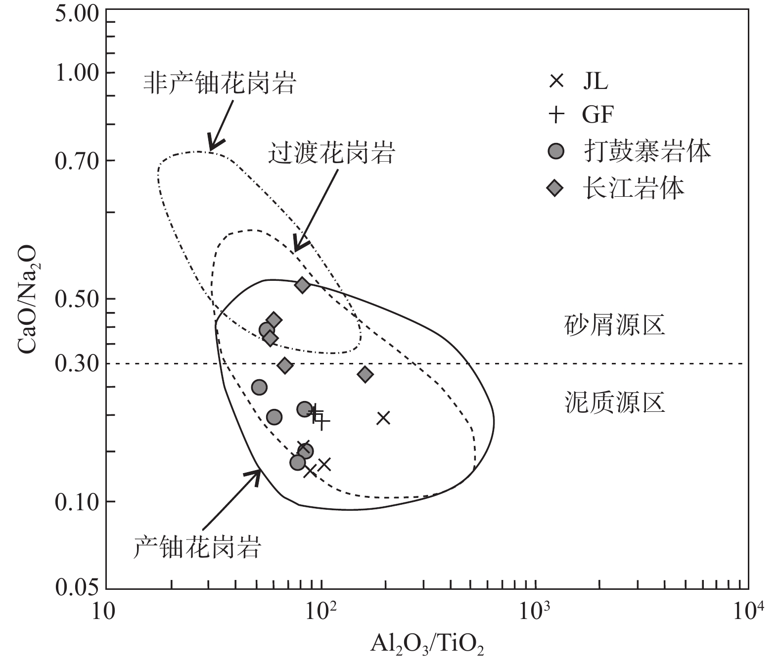
The Dongshang Uranium Deposit is situated in the southern section of the Ganfang Pluton in the Jiuling Orogenic Belt of northwestern Jiangxi Province. The U-bearing granites consist mainly of medium- to coarse-grained, porphyritic biotite(binary) granite. Through zircon and monazite U-Pb geochronology, petrology, and rock geochemistry studies, the U-bearing granites' age, source characteristics, and rock genesis were determined, and their uranium metallogenic potential was also discussed. The LA-ICP-MS analysis showed that the zircon U-Pb intercept and weighted average ages are both 152±1 Ma, and the monazite U-Pb intercept and weighted average ages are 151±1 Ma and 151±2 Ma, respectively, indicating the formation of the U-bearing granites during the early Yanshan period. The major elements exhibit the characteristic of high silica content (SiO2 ranging from 72.1% to 75.6%), high alkalis content (K2O+Na2O ranging from 7.26% to 8.43%), potassium-rich and sodium-poor (K2O/Na2O=1.07 to 1.42), high aluminum (A/CNK=1.12 to 1.29), low titanium content (TiO2 ranging from 0.07% to 0.17%), and iron-poor magnesium (FeOT ranging from 0.75% to 1.28%, MgO ranging from 0.19% to 0.31%), classifying the U-bearing granites as high potassium calcalkaline peraluminous granites. Trace elements Ba, Sr, Nb, and Ti are depleted, while Rb, U, Pb, and Ta are enriched, representing a typical low Ba, Sr granite. The total rare earth elements (ΣREE) are relatively low (∑REE=21.6×10⁻⁶ to 50.7×10⁻⁶), exhibiting a right-dipping light rare earth enrichment pattern with a prominent negative Eu anomaly, which belongs to S-type granites. Based on geochronology and rock geochemical features, it's suggested that the Dongshang U-bearing granites were formed during the syn-collision compressional setting, resulting from the partial melting of the muscovite-rich metapelites of the Anlelin Formation in the Neoproterozoic Shuangqiaoshan Group. High uranium content, high Rb/Sr ratios, Th/U ratios less than 3, and high zircon uranium contents indicate the potential for uranium ore-forming conditions within these granites.

Inside Front Cover
Inside Front Cover
2023, 29(6): 1-1.
Abstract (140) PDF (5528KB)(18)
Abstract:
Inside Back Cover
Inside Back Cover
2023, 29(6): 1-1.
Abstract (107) PDF (5528KB)(14)
Abstract:
Contents of Vol. 29
Contents of Vol. 29
2023, (6): 1-4.
Abstract (86) HTML (46) PDF (364KB)(20)
Abstract:
Active Tectonics & Earthquake
The tunnel damage effects and implications of the coseismic rupture of the Menyuan MS 6.9 Earthquake in Qinghai, China
YAN Yuan
2023, 29(6): 869-878. doi: 10.12090/j.issn.1006-6616.2023027
Abstract (247) HTML (121) PDF (6464KB)(42)
Abstract:
On January 8, 2022, a magnitude 6.9 earthquake occurred in Menyuan County, Qinghai Province, causing severe deformation and damage to the Da Liang Tunnel of the Lanzhou–Xinjiang high-speed railway, which is the first railway tunnel project broken by strike-slip earthquake in China. Through comprehensive analysis of field investigation data, InSAR surface deformation data, and monitoring results from the track control network (CPⅢ), this study delves into the characteristics of deformation and damage caused by the coseismic rupture zone of the Menyuan MS 6.9 earthquake on the Daliang Tunnel. The results indicate that the Haiyuan Fault Zone's Lenglongling–Tuolaishan fault segment is the seismogenic fault for this earthquake, forming a coseismic surface rupture zone approximately 21.5 km long. The dominant deformation nature is left-lateral strike-slip, with a maximum left-lateral displacement of about 3.1 m. As the coseismic rupture zone intersects the Daliang Tunnel, it severely damages the tunnel structure, with the most intense deformation and damage concentrated within 60 m on either side of the central rupture zone. Comparing the observed tunnel deformation with the characteristics of coseismic surface rupture deformation, it is evident that the maximum vertical displacement across the fault zone in the tunnel area is approximately 91.6 cm, with a maximum left-lateral offset of about 2.88 m. The angle between the Lenglongling fault and the Daliang Tunnel is approximately 60°, and the calculated maximum left-lateral offset of the seismogenic fault is about 3.08 m. This indicates a close alignment between the maximum slip offset from coseismic surface rupture and the fault's maximum offset across the tunnel, suggesting that the tunnel structure struggles to resist significant coseismic deformations. The findings of this study can serve as a scientific reference for the planning, construction, and seismic damage prevention of railway projects crossing active fault zones.
Determination of the northeast section of the Nanyuan–Tongxian fault in Beijing and research on its Quaternary activity
NIU Wenzhi, HE Fubing, LIU Zhenhua, CUI Yubin, BAI Lingyan, WANG Anguo, ZHANG Yueze, CAO Mengmeng, ZHOU Jieming
2023, 29(6): 879-887. doi: 10.12090/j.issn.1006-6616.2023032
Abstract (274) HTML (99) PDF (1257KB)(29)
Abstract:
The Nanyuan–Tongxian fault is the boundary fault between the Beijing depression and the Daxing uplift, also the primary seismic-controlling fault of the Beijing M $ 6{\dfrac{1}{2}}$ earthquake in 1665. Its activity is of great significance to land planning and geological disaster prediction in Beijing. Using high-precision gravity, longitudinal-wave and shear-wave seismic comprehensive exploration profiles, and composite borehole geological profiles, this study investigated the geometric characteristics and activity of the northeastern section of the Nanyuan–Tongxian fault. The results show that after passing through Pingjiatuan Village in Tongzhou District, the fault turns to a nearly east-west direction, trending north with a dip angle of 56° to 75°. The new activity in the northeastern section exhibits characteristics of a normal fault, with an estimated buried depth of about 21.6 m, indicating it as a late Pleistocene active fault. The findings demonstrate that the activity age of the northeast section of the Nanyuan–Tongxian fault differs from that of the middle and southwestern sections, providing crucial geological foundations for the spatial planning and disaster reduction systems in the Beijing region.
The activity characteristics and comprehensive geophysical evidence of the Zhangyan–Jinshanwei concealed active fault in Shanghai, China
SONG Chunhua, YU Fei, SHI Gang
2023, 29(6): 888-897. doi: 10.12090/j.issn.1006-6616.2023058
Abstract (205) HTML (66) PDF (3714KB)(27)
Abstract:
The concealed faults in the urban area of Shanghai are well-developed, accumulating several hundred meters of loose sediment layers since the Quaternary. Hindered by the complex and highly disturbed urban environment, the detection and characterization of concealed faults face challenges, posing significant geological risks for urban safety. This study employs high-precision gravity area measurements, high-resolution shallow seismic exploration, and geophysical exploration methods. It integrates geological stratification from surrounding boreholes, stress, and chronostratigraphy analyses (C14 and optically stimulated luminescence) to investigate the Quaternary and current activity of the Zhangyan–Jinshanwei fault. Results show that the fault exhibits good spatial continuity, with evidence reflected in Bouguer gravity anomalies and seismic time profiles. The Zhangyan–Jinshanwei fault is identified as a thrust fault with inherited and newly developed activity characteristics. Its overall trend is northwestward at 315°, dipping southwest, with a fault distance of approximately 10 meters along the bedrock surface. The upper fault point has been displaced to the mid-Pleistocene in the Quaternary. The most recent active period occurred during the mid-Pleistocene, and the current northwestward stress state makes the fault susceptible to extensional and torsional activities. Continuous attention is required for the ongoing activity of this fault. This study's detection approach and findings can serve as a reference for similar urban concealed active fault detection and activity analysis.