Current Issue

2024 Vol. 30, No. 4

Cover Page
Cover Page
2024, 30(4)
Abstract (22) PDF (1337KB)(15)
Abstract:
Contents
Contents
2024, 30(4): 1-2.
Abstract (15) HTML (5) PDF (483KB)(8)
Abstract:
Tectonic System & Structural Geology
Tectonic and geomorphological characteristics of Laoyingshan in the eastern Sichuan-Yunnan block:Insights into the uplift and rotation of the blocks
XU Qinru, DONG Youpu, XIE Zhipeng, REN Yangyang, LI Jiangtao, CAO Dengchi, SU Xiaolong
2024, 30(4): 535-546. doi: 10.12090/j.issn.1006-6616.2023087
Abstract (201) HTML (39) PDF (7428KB)(38)
Abstract:
  Objective  Since the collision and compression of the Indo-European continental plates, the Qinghai-Tibetan Plateau has experienced uplift and intra-land deformationSince the collision and compression of the Indo-European continental plates, the Qinghai-Tibetan Plateau has experienced uplift and intra-land deformation. Similarly, the Sichuan-Yunnan block underwent lateral escape and rotationSince the collision and compression of the Indo-European continental plates, the Qinghai-Tibetan Plateau has experienced uplift and intra-land deformation. Similarly, the Sichuan-Yunnan block underwent lateral escape and rotation. Although extensive paleomagnetic studies have been conducted on the rotation of the central and western parts of the Sichuan-Yunnan rhombic block, less attention has been paid to the rotation of its eastern partSince the collision and compression of the Indo-European continental plates, the Qinghai-Tibetan Plateau has experienced uplift and intra-land deformation. Similarly, the Sichuan-Yunnan block underwent lateral escape and rotation. Although extensive paleomagnetic studies have been conducted on the rotation of the central and western parts of the Sichuan-Yunnan rhombic block, less attention has been paid to the rotation of its eastern part. This study employs fluvial geomorphology, which is highly sensitive to mass rotation, to investigate the rotation and uplift in the Laoyingshan region, situated in the eastern part of the Sichuan-Yunnan block.   Methods  A 30 m resolution digital elevation model (DEM) was used to identify and analyze 22 basins in the study area. Four geomorphological parameters were examined: local topographic relief ratio, longitudinal profile, normalized steepness index, and basin azimuth.   Results  (1) According to regional topographic relief, the low-relief area in the Laoyingshan region is mainly located near the Sijia River and the Baizai River on the western side, whereas the high-relief area is mainly found near the Dabai River and the Gongshan River on the eastern side of the Laoyingshan. The relief around the Dabai and Gongshan Rivers was greater than that around the Sijia River on the western side of Laoyingshan. (2) The normalized steepness index in the Laoyingshan area gradually decreased from north to south. The high-value areas are primarily located near Awang and Jinyuan, corresponding to the east and west branches of the Xiaojiang Fault. In contrast, the low-value areas were mainly distributed at the top of the Laoyingshan and south of the Baozai River in the study area. (3) The results of the river longitudinal profile indicated that the average surface uplift of the area was approximately 358 m. (4) Based on the results of the watershed azimuth angle, the Laoyingshan area underwent a counterclockwise rotation of approximately 15°.   Conclusion  The analysis suggests that since the Late Miocene, the western region of the Sichuan-Yunnan block, located west of the Yuanmou Fault, has experienced fewer effects from strike-slip faults and has predominantly undergone clockwise rotation. Conversely, the eastern region of the Sichuan-Yunnan block, influenced by strike-slip faults, underwent counterclockwise rotation with differential uplift. [ Significance] The fluvial geomorphological index outlines the tectonic rotation of the eastern Sichuan-Yunnan block.
Crustal Stress & Tectonic Stress Field
Differences in crustal stress direction in the southern section of the Huayingshan fault zone in Sichuan Basin: Insights from in situ borehole image logging
TANG Rong, LI Jinxi, LUO Chao, CAI Hongyan, XIE Rongjie, LIU Aodong, GONG Zilong
2024, 30(4): 547-562. doi: 10.12090/j.issn.1006-6616.2023109
Abstract (219) HTML (14) PDF (6756KB)(29)
Abstract:
  Objective  The Huayingshan fault zone, the largest fault zone within Sichuan Basin, exhibits notable differences in geological structures on both sides. Historically, earthquakes with a magnitude of ≤5 have occurred frequently along this fault zone, which remains relatively active to this day, disturbing the crustal stress field of the basin. Clarifying the crustal stress state of the Huayingshan fault zone can enhance our understanding of its active deformation and its tectonic and seismic activities and serve as a reference for subsequent research regarding this fault zone. Currently, geostress studies in this area rely mainly on analyzing seismic data, whereas the investigation of borehole data remains relatively scarce.   Methods  We collected and collated imaging data regarding borehole collapse and borehole-induced tensile fractures from eight borehole logging sites in the southern segment of the Huayingshan fault zone; the geostress directions of these eight boreholes were determined by analyzing these data. Subsequently, a comprehensive analysis of the geostress characteristics was performed by combining the data regarding China’s modern stress field and the earthquake focal mechanism solutions in the southeastern margin of Sichuan Basin.   Results  The maximum horizontal principal stress in four boreholes located in the southern region of the southern segment of the Huayingshan fault zone was oriented in the NWW-SEE direction, which aligns with the regional stress field direction in Sichuan Basin; only one borehole in the southern region exhibited a maximum horizontal principal stress in the NEE—SWW direction, representing a counterclockwise deviation relative to the regional stress field of Sichuan Basin. Meanwhile, the maximum horizontal principal stress in all three boreholes in the central region of the southern segment of the Huayingshan fault zone was also oriented in the NEE—SWW direction, representing a counterclockwise deviation relative to the regional stress field of Sichuan Basin.   Conclusion  Through the comprehensive analysis of the above results and the tectonic features and basement properties of the study area, the following conclusions are drawn: (1) The deviations in stress direction in the southern segment of the fault zone are primarily caused by the combined effects of changes in the basement properties of the region, tectonic stress near the boreholes, and the regional stress field. (2) The geostress characteristics obtained in the present study, along with the focal mechanism solutions of earthquakes in the southern segment of the Huayingshan fault zone, indicate that the stress direction in the southeastern margin of Sichuan Basin is relatively divergent, resulting from the combined effects of complex local structures and the regional stress field in this region.   Significance  The present study aims to supplement the geostress data regarding the southern segment of the Huayingshan fault zone based on borehole data, analyze the current stress field state of the rock mass, and determine the direction of the maximum horizontal principal stress. These findings will provide supporting geostress data for subsequent research on the frequent seismic activities in this region.
Energy Resources Geology
Fracture network complexity of tight sandstone and its influencing factors
LIU Shengxin, FU Huiqi, FENG Xingqiang, HAN Xiaoxiang, WANG Bingqian
2024, 30(4): 563-578. doi: 10.12090/j.issn.1006-6616.2023128
Abstract (315) HTML (57) PDF (4410KB)(38)
Abstract:
  Objective  Fracture network analysis plays an important role in oil and gas exploration and development. However, complexity analysis of tight sandstone fracture networks and their control factors is relatively lagging. Based on an experimental study of the dynamic evolution of the complex fracture network in tight sandstone, the fractal and multifractal spectral characteristics of the fracture network were defined, and the complexity and main controlling factors of the fracture network were analyzed. Fracture network complexity analysis of tight sandstone plays an important role in hydraulic fracturing optimization, fracture network prediction, and fracture modeling.  Methods  Rock mechanics and X-ray computed tomography scan experiments determined the characteristics of rock mechanics and fracture networks . The microstructure and fracture network fractal characteristics of tight sandstone were quantitatively characterized by SEM and fracture network fractal analysis.  Results  The results showed that the quartz content of tight sandstone ranges from 28.08 to 52.88%, clay content ranges from 11.54 to 25.45%, particle size ranges from 61.18 to 184.55 μm, and porosity ranges from 8.125 to 10.296%. Uniaxial compressive strength ranges from 69.09 to 188.33 MPa, and the elastic modulus ranges from 31.69 to 92.76 GPa. The fractal dimension (DB) ranges from 1.28 to 2.35 and average spectral width (Δα) ranges from 1.0851 to 1.3638.  Conclusion  The initiation and propagation of fractures extend through the entire stress–strain process. The complexity of the fracture network of tight sandstone is mainly controlled by microscopic fabric characteristics, and has obvious confining pressure as well as scale effects. The DB of the three-dimensional fracture network and average Δα of the multifractal spectrum represents the complexity and heterogeneity of the fracture spatial distribution, respectively, and are relatively independent. As the content of quartz, feldspar, and other brittle minerals in sandstone increases, the porosity of the reservoir increases, particle size of the sandstone decreases, DB of the fracture network increases, and average Δα decreases. In the absence of confining pressure, the complexity of the sample fracture network is mainly controlled by the microscopic fabric characteristics, and the complexity increases with increase of axial pressure. When present confining pressure plays a leading role; the higher it is, the lower the DB value, and the higher the mean Δα value. Clay minerals are unconducive to complex fractures formation. The mean values of DB and Δα of small-scale samples are greater than those of large-scale samples. The elastic modulus and compressive strength of sandstone are positively correlated with DB and mean Δα.
Diagenesis of microbial dolomite reservoirs in the second Member of Dengying Formation of Ediacaran in the Penglai area, Sichuan Basin: Insights into the formation and evolution of high-quality reservoirs
WANG Yaping, BAO Zhidong, ZHANG Lianjin, YANG Dongfan, WEN Wen, ZHONG Yuan, TANG Pan
2024, 30(4): 579-594. doi: 10.12090/j.issn.1006-6616.2024062
Abstract (78) HTML (30) PDF (6099KB)(16)
Abstract:
  Objective  The microbial dolomite of the second Member of the Dengying Formation(Deng 2 Member) in the Penglai area of the Sichuan Basin is widely distributed and considered a potential target for deep carbonate oil and gas exploration. Unlike conventional high-quality reservoirs characterized by porosity and karst fractures, the carbonate rocks of the Deng 2 Member mainly consist of microbial dolomite. The genesis and diagenetic evolution of these high-quality reservoirs remain unclear.   Methods  This study employed petrographic thin sections, scanning electron microscopy (SEM), cathodoluminescence, and computed tomography (CT)scanning to conduct a detailed analysis of the microbial dolomite reservoirs in the Dengying Formation, using field outcrop and core samples. The aim was to gain a deeper understanding of the effects of diagenesis on pore formation and the development of high-quality reservoirs.   Results and Conclusion   The microbial carbonate reservoirs in the study area were characterized by low porosity and very low permeability, predominantly consisting of fracture-porosity (cavity) type microbial dolomite. The reservoir space was primarily composed of intergranular dissolution pores, residual framework dissolution pores, intragranular dissolution pores, and small to medium-sized dissolution cavities, with minor occurrences of intercrystalline pores and intercrystalline dissolution pores. The Deng 2 Member has undergone multiple diagenetic processes; penecontemporaneous dissolution and early epigenetic dissolution were key factors in enhancing porosity.   Significance   These findings enhance the understanding of the genesis of high-quality microbial carbonate reservoirs in the Ediacaran System of the Sichuan Basin and provide valuable information for deep oil and gas exploration and development in the region.
Characteristics of life-cycle stages and reservoir control in the development of extensional faults in the Dongying Sag
JI Qingjia, ZHOU Weiwei, HAN Runsheng, HU Yang
2024, 30(4): 595-608. doi: 10.12090/j.issn.1006-6616.2023147
Abstract (81) HTML (19) PDF (3936KB)(19)
Abstract:
  Objective  Faults are among the most prevalent geological structures in oil and gas basins. Because of their significant connection to oil and gas resources, they have consistently attracted the attention of experts and scholars in the field, making them a hot research topic. Although previous researchers delved tirelessly into the correlation between faults, oil, and gas, new theoretical breakthroughs have been steadily emerging and have been used to promote advancements in oil and gas exploration. Nonetheless, there continues to be a dearth of thorough investigations into the underlying links between faults and the formation and distribution of oil and gas reservoirs, as well as methods for comprehensively and quantitatively defining the connections between faults and oil and gas.   Methods  The formation of a fault from inception encompasses multiple stages of development, including implicit and explicit stages, and differentiating the diverse growth stages of a fault, ranging from the initial embryonic stage to the terminal stage, poses a significant challenge. To address this issue, the Dongying Sag in the Bohai Bay Basin was selected as the focal point of this study. By employing physical and numerical simulation techniques, the researchers sought to replicate the entire life cycle evolution of the Chennan Fault, a basin-controlling boundary fault, from its embryonic stage to its terminal stage while elucidating the distinct characteristics of each stage. Building upon this foundation, the relative ages of the primary faults in the Dongying Depression and the various modes of fault activity at different stages were qualitatively and quantitatively determined, leading to the establishment of a reservoir-control model.   Results  The research findings indicate that normal faults tend to grow in six distinct stages: the embryonic stage (0 < RA (relative age) ≤ 1), characterized by microfractures or induced fracture zones; juvenile stage (1 < RA ≤ 2), with an intermittent connection of fault geometry; mature stage (2 < RA ≤ 3), marked by the connection of plate-like fault geometry and clear fault throw; declining stage (3 < RA ≤ 4), in which induced fracture zones form on both sides of the fault core, resulting in a shovel-like fault geometry; terminal stage (4 < RA ≤ 5), ramp-flat fault geometry, which has complex derived structures; and death stage (5 < RA ≤ 6), in which fault movement stops or undergoes inversion. The activity pattern of a fault is intricately linked to the duration and intensity of its age. Stable continuous, and high-intensity fault activity promotes the evolution of faults into their terminal stage. Research on reservoir control traps indicates that faults can create reservoirs at all stages of their development. However, as faults age, their ability to control reservoir formation strengthens. The types of traps influenced by faults transition from individual, isolated structures to a variety of arrangements. Moreover, the diversity of oil and gas reservoirs evolves from singular to multifaceted, and the size of these reservoirs expands from small to large. The embryonic and juvenile stage faults primarily influence closure; the mature stage faults predominantly impact sand and reservoir; and the declining stage and terminal stage faults primarily govern the overall distribution range of source rocks, as well as the migration, accumulation, and dissipation of oil and gas.   Conclusion  The reservoir control potential of the Chennan Fault was assessed by considering factors such as reservoir control advantages, the degree of oil and gas enrichment, and the scale of oil and gas accumulation. The reservoir control capacity of the Chennan Fault was classified as “strong.” Reevaluation of the fault’s reservoir control potential from the perspective of its developmental and evolutionary stages significantly enhances and elevates theoretical research on fault reservoir control and also advances exploration efforts in established mature areas. [Significance] Identifying the formation age and evolutionary patterns of extensional faults has immense theoretical and practical importance for comprehending alterations in the fault’s reservoir control capabilities. Moreover, it offers crucial guidance for oil and gas exploration, particularly for enhancing the reserves in existing exploration areas.
3D digital modelling and detailed anatomy of tight sandstone reservoir outcrop with oil-bearing heterogeneity: A case study of Angou outcrop of Triassic Yanchang Formation in Ordos Basin
ZHANG Xiaoyin, ZHAN Rongruo, DUAN Liang, LUO Xiaorong, WEI Ronghao
2024, 30(4): 609-621. doi: 10.12090/j.issn.1006-6616.2024028
Abstract (68) HTML (26) PDF (5277KB)(16)
Abstract:
  Objective  Our understanding of architecture-controlled oil-bearing heterogeneity shown in tight sandstone reservoirs is hindered by scarcity of large-scale oil-bearing outcrops. Triassic lacustrine delta and fluvial succession exposed in a quarry near Angou village (Yanchang county, northern Shannxi province) is an analog for buried oil-bearing tight sandstones in the Ordos basin.   Methods  In this study, 3D digital outcrop modeling was carried out on the oil-bearing sandstone outcrop of Angou by using Unmanned Aerial Vehicle(UAV) multi-point aerial photography, and then the depositional sequence diagenetic anatomy and field anatomy were carried out on the 3D digital model of Angou oil-bearing sandstone outcrop. Based on field observations, drone-based measurement and digital outcrop modelling, continuous sampling using Husquvarna power cutter and petrographic and diagenesis analysis under section, a 2D architectural heterogeneity model incorporating spatial configuration of effective reservoir was created.   Results  The UAV 3D digital outcrop modeling and field dissection revealed that the oil charging was only distributed within the interior, but not at the top or bottom of sand body. The configuration and nature of bounding surface underlying this succession was reconstructed with reference to lateral tracing for distinctive markers and a detailed measured profile with facies and sequence stratigraphic analysis. The results show that the sedimentary environment of oil-bearing tight sandstone is curved river channel. In the quarry, fluvial sandstone succession is underlain by a regional surface interpreted as a third-order sequence boundaries on the basis of abrupt landward facies change and locally developed incised valleys <20 m deep. Architectural heterogeneity within the amalgamated sandbody is expressed by multiple fifth-order storey surfaces, sixth-order barform and seventh-order bedform. Continuous sampling and thin-section observation of outcrops show that the completely different structural properties and diagenetic characteristics of the top, bottom and interior of a single sand layer are the fundamental reasons for the different oil bearing in outcrops. The discovery of the Angou oil-bearing outcrop provides a rare field example for the objective understanding of the oil-bearing heterogeneity of the reservoir controlled by the configurational interface in the sand body.   Conclusion  In this study, the specific characteristics of oil-bearing heterogeneity in oil-bearing sandstone outcrop are described, the sedimentary background and possible levels of different configuration interfaces of extremely thick oil-bearing sandstone are revealed, and the causes of oil-bearing heterogeneity developing in sand bodies are qualitatively understood. [ Significance ] Of importance, the discovery and detailed anatomy of Angou outcrop provide direct geological evidence showing that sedimentation and diagenesis exert a strong control on the quality and heterogeneity of most tight clastic reservoirs.
Cenozoic tectonic-thermal history reconstruction of the Qinnan Depression, Bohai Basin
GAO Yufei, TANG Xiaoyin, YANG Shuchun, ZHAO Xinyan, HU Shengbiao
2024, 30(4): 622-632. doi: 10.12090/j.issn.1006-6616.2023168
Abstract (213) HTML (29) PDF (1182KB)(18)
Abstract:
  Objective  Tectono-thermal history is important to understand basin evolution and its geodynamic mechanism and is the key question to be solved for source rock maturation study. With the increasing energy demand and difficulty in oil and gas discovery on land, sea basins have gradually become an important alternative for oil and gas exploration and a hotspot of national energy strategy research. The Qinnan Depression, located in the northwest of the Bohai Sea, has good exploration prospects. However, owing to the low level of exploration, research on the tectono-thermal evolution of Qinnan Depression is still limited.   Methods  In this study, 25 artificial wells have been established based on 3 seismic profiles of the Qinnan Depression, and their tectonic subsidence and thermal history have been modeled to reconstruct the tectonic-thermal evolution history using a multi-stage finite stretching model.   Results  The results indicate that since the Cenozoic era, the Qinnan Depression has undergone three stages of rifting and stretching during the sedimentary periods of the Kongdian Formation to fourth member of the Shahejie Formation (65–42 Ma), the third member of the Shahejie Formation (42–38 Ma), and the third member of the Dongying Formation (32.8–30.3 Ma), with a total stretching factor of 1.27–2.05. Corresponding to the three stages of stretching, the basal heat flow of the Qinnan Depression has experienced three stages of increase, reaching a peak of 64.0–89.0 mW/m2 at the end of the deposition of the third member of the Dongying Formation (~30.3 Ma), and then decreased gradually until present.   Conclusion  The Qinnan Depression underwent three phases of heating and two stages of cooling since the Cenozoic period. There is a good coupling relationship between the tectonic-thermal evolution process and fault activity in the Qinnan Depression.   Significance  The parameters such as tension system and basement heat flow history obtained in this study are of great significance for understanding the deep dynamic mechanisms of basin tectonic evolution and guiding oil and gas exploration.
Geo-hazards & Engineering Geology
Application of integrated model based on EEMD-CNN-LSTM for landslide-displacement prediction
LIU Hangyuan, CHEN Weitao, LI Yuanyao, XU Zhanya, LI Xianju
2024, 30(4): 633-646. doi: 10.12090/j.issn.1006-6616.2023145
Abstract (524) HTML (72) PDF (6578KB)(51)
Abstract:
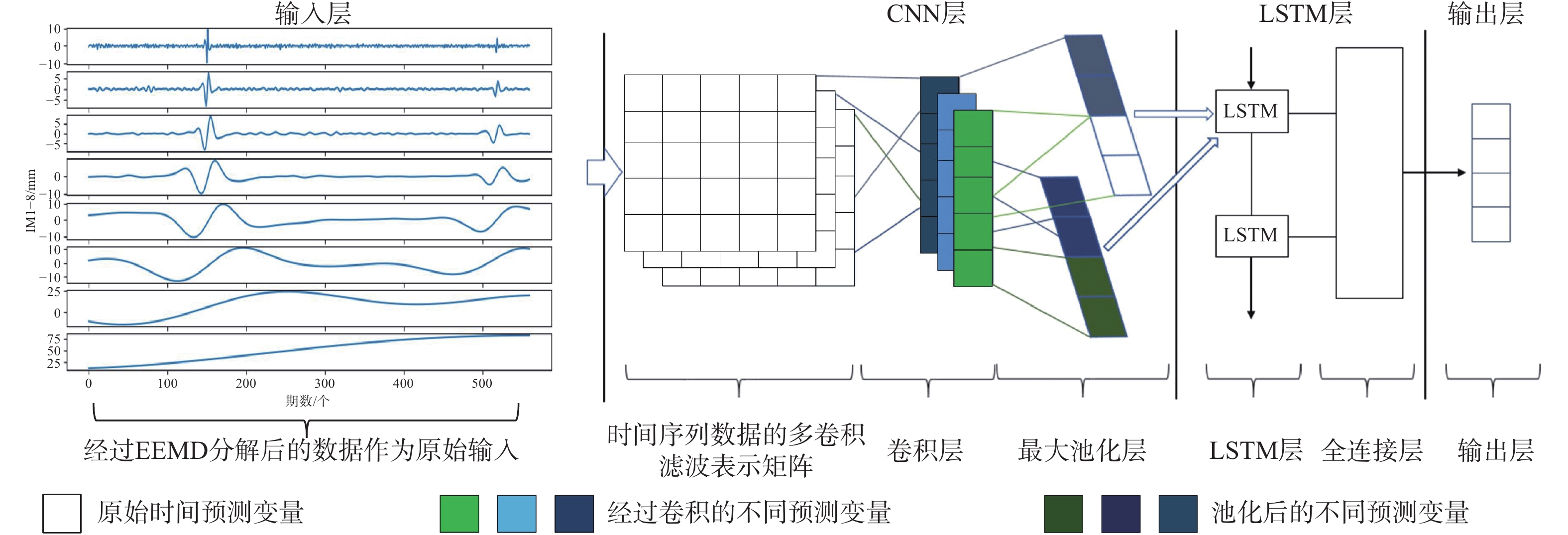
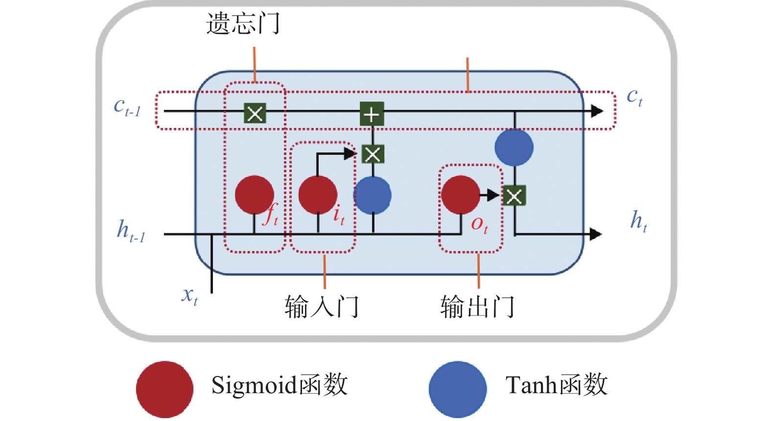
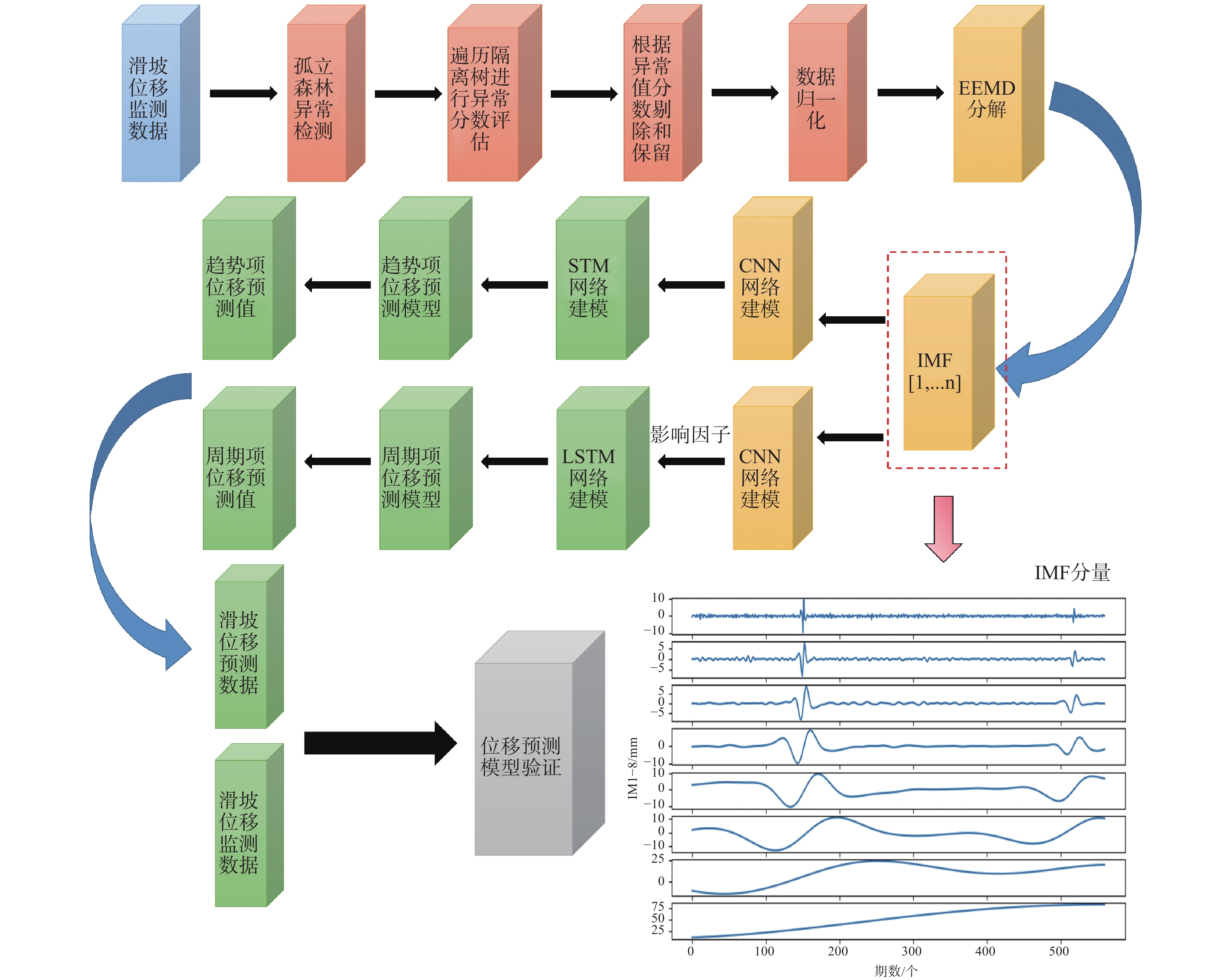
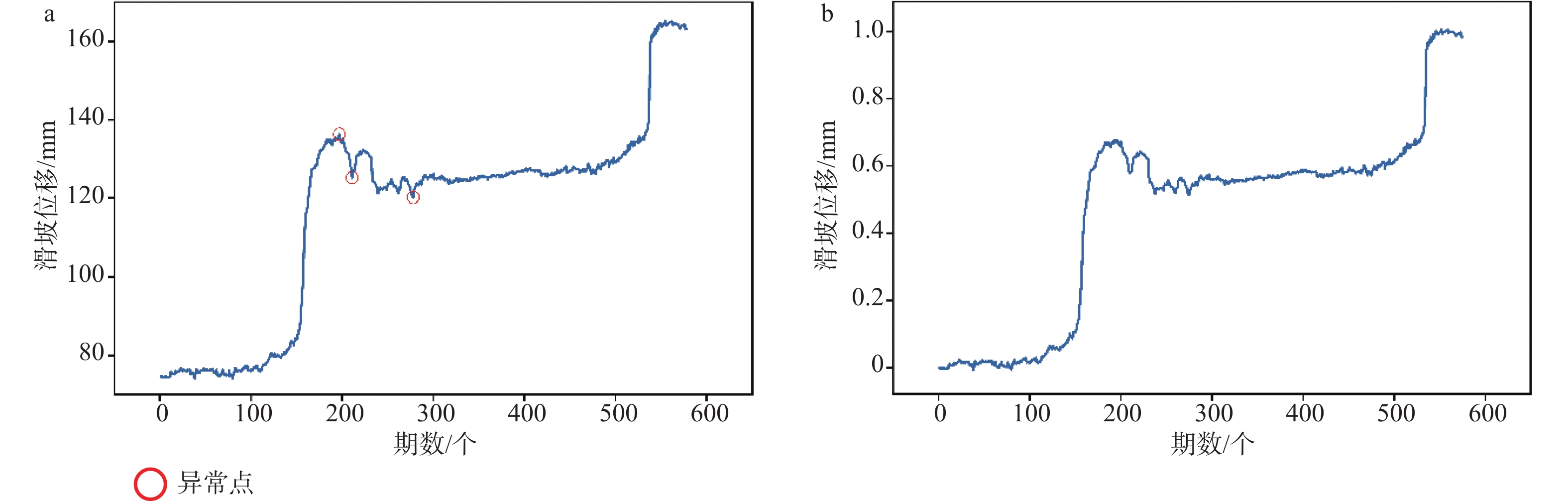
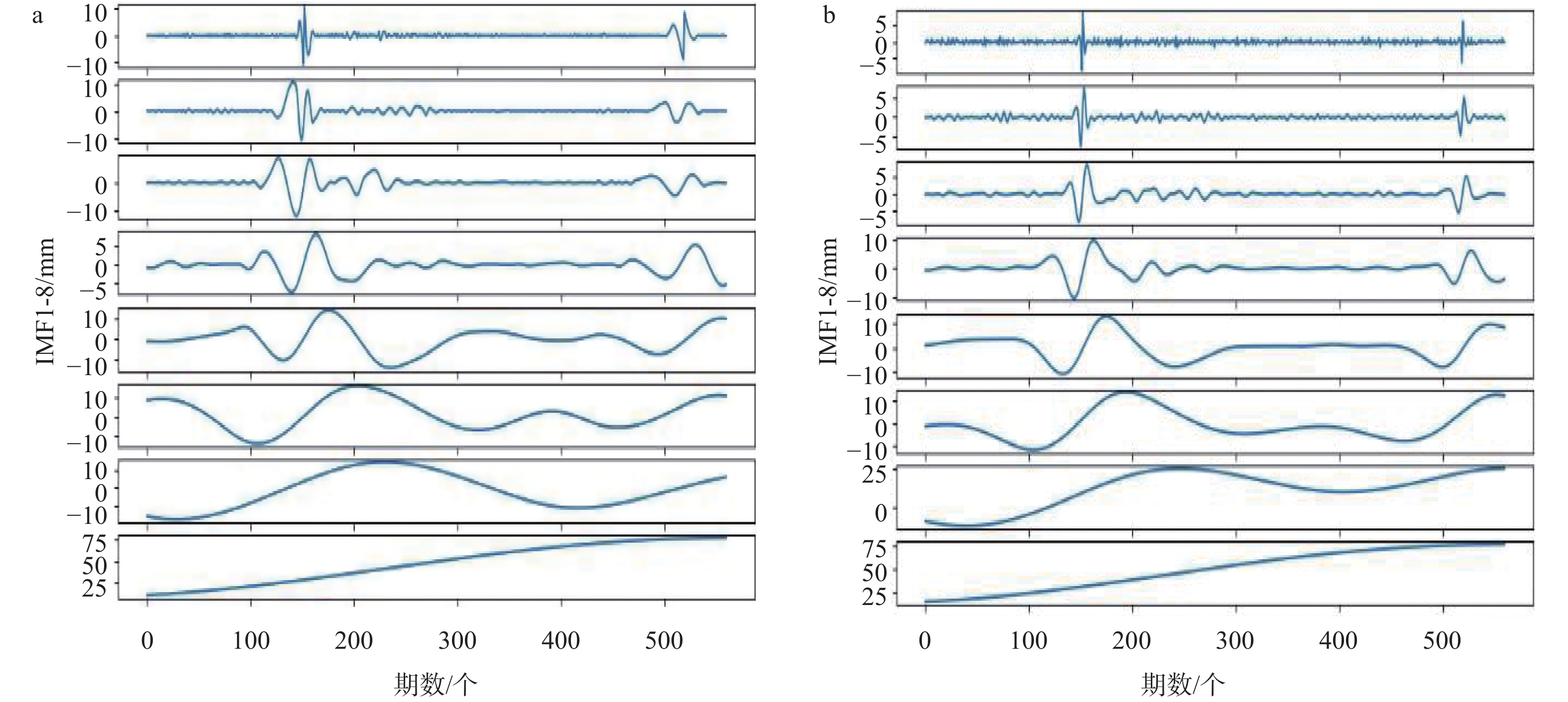
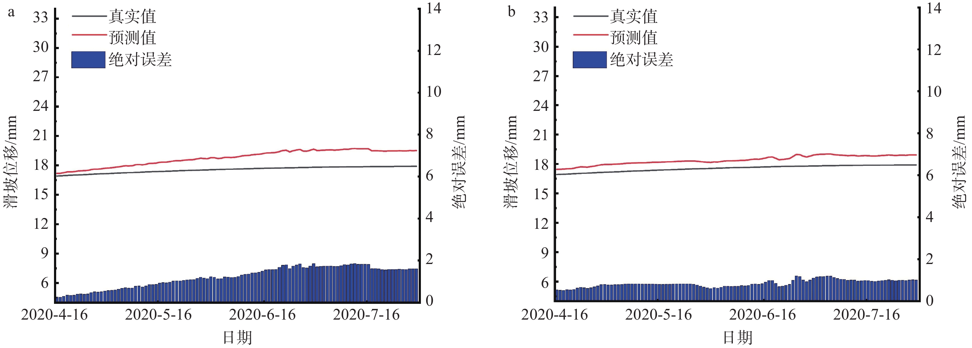
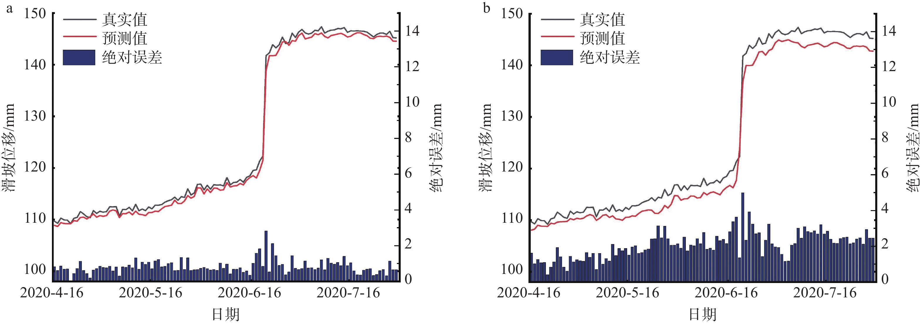
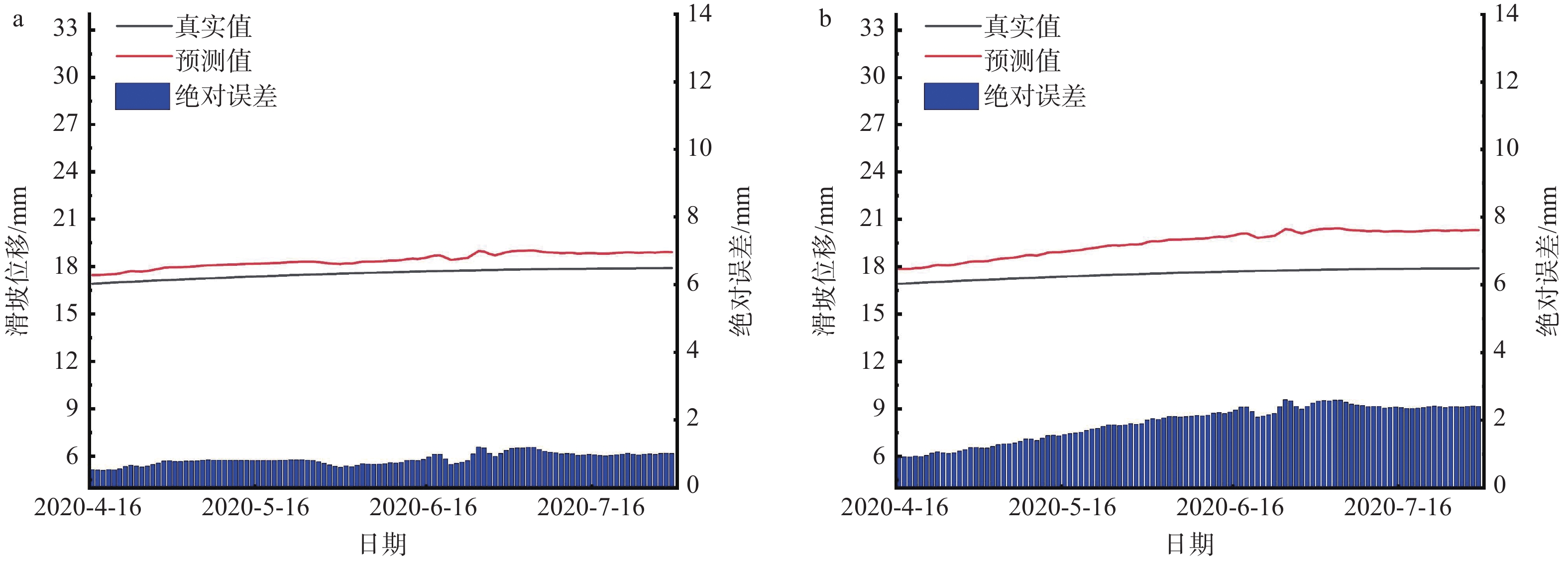
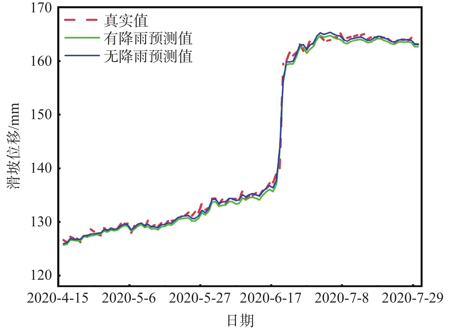
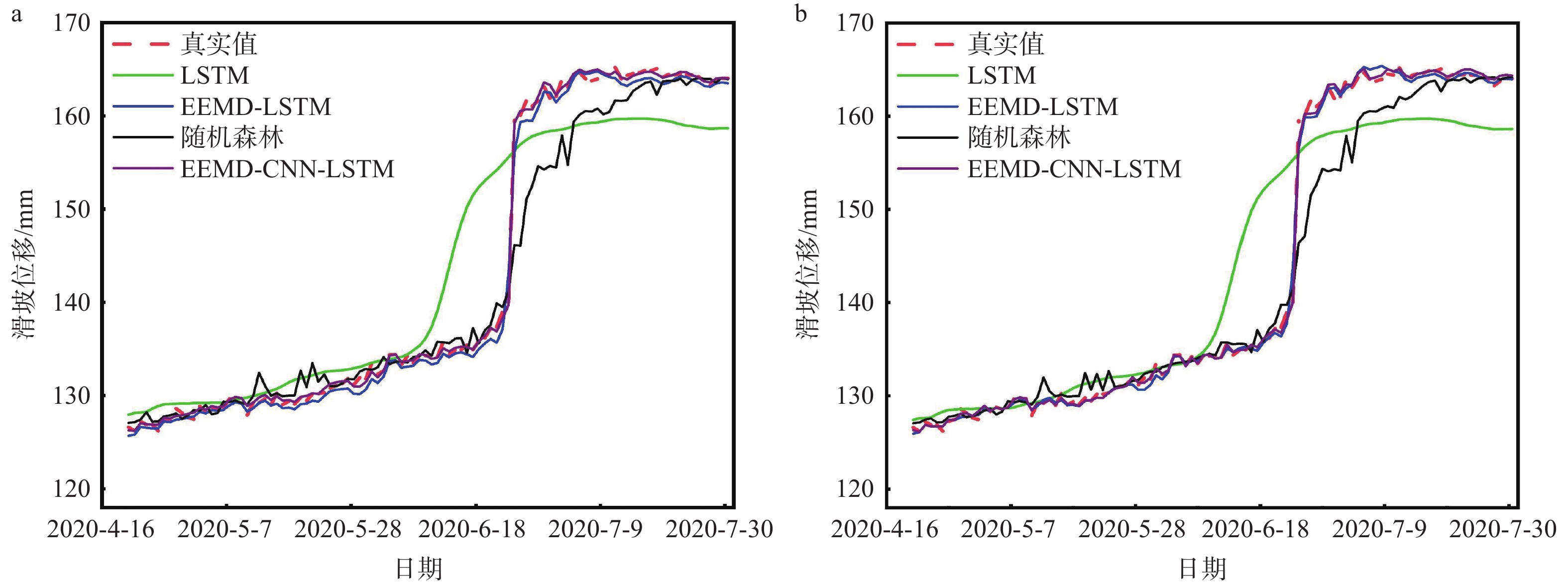
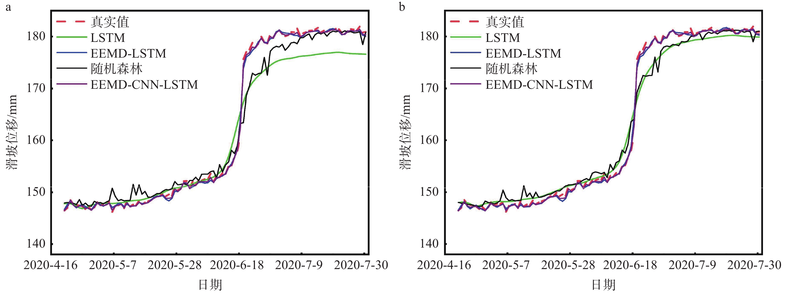
  Objective  Landslide-displacement prediction is critical when evaluating landslide stability. Despite the achievements of time-series methods based on deep-learning paradigms in predicting landslide displacement, the nonstationary, periodic, and trending characteristics of landslide displacement data cause multivariate predictions of current time-series models to easily overfit. Existing studies primarily focus on improving single models, whereas systematic studies pertaining to multimodel integration methods are scarce. This study aims to develop an integrated model that addresses these challenges and improves prediction accuracy.   Methods  Considering the volatility of landslide-displacement data and the combined characteristics of their periodic and trending displacement components, a landslide-displacement prediction model combining isolation forest (IF) anomaly detection, ensemble empirical mode decomposition (EEMD), convolutional neural networks (CNNs), and long short-term memory (LSTM) neural networks is proposed. The stepped Baijiabao landslide in the Three Gorges Reservoir area, which is affected by rainfall, is investigated in this study. First, the IF algorithm is introduced to detect anomalies in the original landslide-displacement data. This enables outliers, which can distort the prediction results, to be identified and excluded. Subsequently, EEMD is adopted to decompose the displacement data into intrinsic mode functions (IMFs), which represent the underlying periodic and trend components. This decomposition allows one to analyze the inherent characteristics of the data more comprehensively. Next, a CNN is employed to capture local periodic and trend patterns within the IMFs. CNNs are particularly effective in recognizing spatial patterns and features, thus rendering them suitable for identifying complex patterns in the displacement data. Finally, the overall displacement is predicted using the LSTM model, which is suitable for accommodating sequential data and capturing long-term dependencies. These techniques are integrated to leverage their respective strengths, thereby improving the prediction accuracy.   Result  The results indicate that the root-mean-square error(RMSE), mean absolute error(MAE), absolute percentage error in evaluation (MAPE), and determination coefficient(R2)indices of the EEMD-CNN-LSTM model for predicting the overall landslide displacement under rainfall conditions are 0.4190, 0.3139, 0.2379, and 0.9997, respectively, which signify improvements in the accuracy of the first three evaluation indices by 32.3%, 25.1%, and 7.3%, respectively, compared with those of existing models. This significant improvement demonstrates the model’s robustness in accommodating the complexities of landslide-displacement data under varying conditions. For predictions without rainfall, the RMSE, MAE, MAPE, and R2 indices are 0.4302, 0.2908, 0.2431, and 0.9996, respectively, which signify improvements in the accuracy of the first three indices by 31.2%, 31.7%, and 8.7%, respectively, compared with those of existing models. These results highlight the model’s high generalizability across different scenarios, as it can maintain high prediction accuracies regardless of external influencing factors such as rainfall. Compared with conventional LSTM, random forest, and EEMD-LSTM models, the EEMD-CNN-LSTM model offers significant advantages under the influence of rainfall and without rainfall, thus significantly reducing overfitting and improving the prediction accuracy. The hybrid approach effectively captures the intricate patterns in the data, which cannot be achieved by single models.  Conclusion  In summary, the multimodel integration method based on IF anomaly detection, EEMD decomposition, local-feature capturing by the CNN, and overall prediction by LSTM significantly improves the accuracy of landslide-displacement prediction, particularly under the influence of rainfall. The integrated model not only addresses the overfitting issues typically encountered in time-series prediction models but also enhances the model’s robustness and reliability. The combination of IF for anomaly detection ensures that outliers do not skew the prediction results, whereas EEMD facilitates the decomposition of data into meaningful components. The CNN’s ability to capture local patterns, coupled with the LSTM’s strength in modeling long-term dependencies, enables the establishment of a comprehensive framework that can effectively accommodate the complexities of landslide displacement data.[ Significance ]This study provides an effective multimodel integration method for landslide-displacement prediction, which addresses the overfitting issues in existing models as well as offers substantial scientific significance and practical value. The proposed model’s ability to accurately predict landslide displacement under varying conditions is extremely beneficial to the stability evaluation of landslide-prone areas, thereby contributing to disaster prevention and mitigation efforts. The innovation is based on the systematic integration of anomaly detection, data decomposition, and advanced neural-network techniques, which results in a robust framework that outperforms conventional methods. The findings of this study are applicable to real-world scenarios, thereby enhancing the accuracy and reliability of landslide monitoring systems and supporting informed decision-making in hazard management and infrastructure development.
Development characteristics and risk assessment of geological hazards in the mountainous and hilly areas of western Zhengzhou City
ZHANG Jianyu, LYU Dunyu, LIU Songbo, WANG Cuiling, MENG Shuran
2024, 30(4): 647-658. doi: 10.12090/j.issn.1006-6616.2022116
Abstract (173) HTML (24) PDF (4247KB)(47)
Abstract:
  Objective  The mountainous and hilly areas of western Zhengzhou City have a complex geological environment, affected by rainfall and human engineering activities. Geological hazards such as collapses, landslides, and debris flows occur frequently. In particular, the “7·20” extreme rainstorm that occurred on July 20, 2021 caused many geological hazards, resulting in heavy casualties and huge economic losses. Therefore, analyzing and summarizing the development characteristics of geological hazards and conducting a risk assessment is necessary for this region. At present, the risk assessment of geological hazards is mainly conducted using a single method that has limitations including slightly low evaluation accuracy. In addition, an overall geological hazard risk assessment has not yet been conducted in the mountainous and hilly areas of western Zhengzhou City.  Methods  Based on the research and analysis of the geological environment background and the distribution characteristics of geological hazards in the study area, eight evaluation factors were selected: slope, landform, engineering geological rock group, elevation, distance from fault, distance from river, rainfall, and human engineering activities. The weighted information method which incorporates elements of the information quantity model and analytic hierarchy process, was used to evaluate the risk of geological hazards in the study area.  Results  The low-, medium-, and high-risk areas are 1387.14 km2, 1803.18 km2, and 1066.47 km2, respectively, accounting for 32.59%, 42.36%, and 25.05% of the total area, respectively. The medium- and high-risk areas are mainly distributed in the tectonic erosion medium-low mountains and loess hills in the central part of the four cities, the tectonic erosion medium-low mountains south of Dengfeng, and the loess hilly areas in northern Gongyi and Xingyang. The terrain has steep slopes and deep gullies, and the main stratigraphic lithology is clastic rocks intercalated with carbonate rocks, soft and hard rock layers, and loess. Fault structures are developed, and geological hazards are prone to occur under the action of inducing factors and are highly dangerous. The majority (93.11%) of geological hazards are distributed in medium- and high-risk areas, with hazard point densities of 0.1752 km−2 and 0.2869 km−2, respectively. The spatial distribution of geological hazard points is consistent with the geological hazard risk assessment results. The rationality of the evaluation results was assessed by a Receiver Operating Characteristic curve, yielding an AUC value of 0.868. The evaluation accuracy met the requirements for hazard assessment.  Conclusion  Geological hazards have the largest information value in the range of >40° slopes loess hilly landforms, loess engineering geological rock groups, and 24-h maximum rainfall of 500–550 mm. The risk of geological hazards is positively correlated with distance from faults and water systems — the closer the distance, the higher the risk. The risk of geological disasters in the study area is controlled by the terrain slope and landform and is closely related to the lithology of the formation, which is an important factor in inducing geological disasters. The weighted information method, which has high accuracy and rationality, was used to evaluate the geological hazard risk.   Significance  The results of this study can provide a basis and technical support for geological hazard prevention and management in the mountainous and hilly areas of western Zhengzhou City and serve as a valuable point of reference for urban planning and infrastructure geological hazard risk assessment in the study area.
Debris flow hazard analysis before and after improvement of Hanjia gully control engineering at the source area of the Fujiang River
TANG Haibing, WU Jianjun, ZHANG Chunshan, YANG Weimin, QU Jingkai, MA Siqi, XU Chuancheng
2024, 30(4): 659-672. doi: 10.12090/j.issn.1006-6616.2023097
Abstract (172) HTML (24) PDF (13672KB)(20)
Abstract:
  Objective  Debris flow from the Hanjia gully develops on the left bank of the source area of the Fujiang River, Fenghe Village, Xiaohe Town, Songpan County, China. In recent years, debris flows have occurred frequently, and the largest debris flow occurred in August 2022, which seriously threatened the lives and properties of villagers in the Hanjia gully. Existing prevention and control engineering methods have decreased in effectiveness or even become ineffective. Currently, researchers have set a variety of extreme rainfall conditions and used FLO-2D to analyze the hazards of debris flow, based on which the governance effect of debris flow prevention and control engineering can be evaluated. However, there are few reports on how to improve the prevention and control engineering and evaluate the effect of the improved prevention and control engineering when the existing prevention and control engineering is ineffective.  Methods  To reduce damage to the Hanjia gully, the characteristics as well as prevention and control status of the debris flow in/from this gully were determined using remote sensing interpretation, field investigation, and FLO-2D numerical simulation; subsequently, improved prevention and control engineering was proposed. The hazard of debris flow before and after the improvements in prevention and control engineering under different rainfall frequencies were studied to analyze the effectiveness of the improved prevention and control engineering.  Results  The results show that the Hanjia gully is located in the "8.8" Jiuzhaigou earthquake disturbance area, the static reserves of post-earthquake landslides and collapses are about 49.79 × 10⁴ m3, and the debris flow sources are abundant, which leads to frequent debris flow during heavy rainfall. The high-hazard area is concentrated in the No. 1 retaining dam, and Fenghe Village and Pingsong Highway are in the low-hazard area under a rainfall event occurring every 10 years, and the existing prevention and control engineering can effectively prevent the debris flow disaster. Under a rainfall event occurring once in 50 years, Fenghe Village is in the high-hazard area of debris flow. The debris flow rushes out of the drainage channel and destroys the Pingsong Highway. The maximum mud depth in the accumulation area increases from 1.41 m to 3.14 m, the maximum velocity increases from 2.4 m/s to 3.65 m/s, and the accumulation area increases from 0.28 × 10⁴ m2 to 5.41 × 10⁴ m2. However, the existing prevention and control engineering methods cannot meet these requirements. After adopting improved prevention and control engineering, such as multistage retaining dams and cutting and straightening of drainage channels, the flow velocity of the debris flow in front of the two additional retaining dams becomes lower than that before the improvement, and the depth of mud in front of the additional retaining dams becomes higher than that before the improvement. The maximum velocity of the debris flow within 100 m of Dam No. 3 decreases by 29%, and the maximum mud depth increases by 413%. The maximum flow velocity in the first 100 m of Dam No. 2 decreases by 21%, the maximum mud depth increases by 175%, the maximum mud depth in the accumulation area is 3.9 m, and the maximum flow velocity is 3.4 m/s. The accumulation volume of debris flows is reduced by 50.2%, and the accumulation area is reduced by 86%.  Conclusion  Improved prevention and control engineering can effectively reduce the solid mass of debris flows and guide debris flow to discharge along drainage channels. The high-hazard area of the debris flow is concentrated in the drainage channel, and the control effect of the debris flow is remarkable.  Significance  The research results provide a scientific method for evaluating the effectiveness of debris-flow control engineering improvements and offer technical support for local debris-flow early warning systems.
Quaternary Geology & Environment
The evolutionary process of Cenozoic Asian monsoon
LIN Xu, WU Zhonghai, DONG Yanyu, XIE Yuanyun, LIU Haijin, LI Zhaoning
2024, 30(4): 673-690. doi: 10.12090/j.issn.1006-6616.2023093
Abstract (205) HTML (20) PDF (3727KB)(40)
Abstract:
  Objective  The formation of monsoon climates is attributed to the seasonal reversal of wind direction and precipitation caused by the difference in thermal capacity between land and ocean. Asia is recognized as the most prominent region globally, with monsoon climates, that affect the largest population. The heavy rainfall accompanying monsoons can result in various secondary disasters, substatially jeopardizing human safety and productivity in the region. Consequently, comprehending the formation process of the Asian monsoon holds paramount importance.   Methods  This study aim to employ geological concepts to establish a connection between the past and present, providing an overview of the components of Asian monsoons, identifying the primary factors influencing their formation and evolution, and summarizing research progress on the South Asian and East Asian monsoons based on sediment records from key Asian locations.   Results  The findings indicate that during the Cenozoic, the collision between the Indian Plate and the southern margin of the Asian continent altered the distribution of land and sea in Asia. Consequently, the Tibetan Plateau experienced initial uplift, contributing to the emergence of monsoon climates in South Asia and East Asia. However, at this stage, the East Asian region was still primarily influenced by the planetary wind system, and the East Asian monsoon was in its early stages, predominantly restricted to the southern margin of the South China Plate in a localized manner. In contrast, the South Asian Monsoon covered a relatively extensive area. This discrepancy may be attributed to the delayed opening of marginal seas in the East Asian region compared to the relatively earlier occurrence of land and sea distribution in South Asia. However, as the Tibetan Plateau continued to uplift and approach its current altitude during the middle to late Cenozoic, the Asian monsoon entered a strengthening phase, notably impacting regional geological evolution processes. Since the middle to late Cenozoic, the development of the North and South Polar ice caps and the upliftment of the Tibetan Plateau have controlled the Asian monsoon, leading it to undergo multiple stable periods of development.   Conclusion  The development and evolution of the East Asian and South Asian monsoons are mainly driven by the distribution of sea and land in the Asia, the upliftment of the Tibetan Plateau and the global climate change during the Cenozoic.  Significance   These findings provide valuable insights into the scientific and rational utilization of the Asian monsoon for conducting systematic Earth science research in Asia.
Karst groundwater enrichment law in Laiwu Basin
LI Bo, YU Dalu, WANG Nan, BI Wenwen, GAO Shuai, XU Qin, WANG Yuwei, HOU Peng
2024, 30(4): 691-702. doi: 10.12090/j.issn.1006-6616.2023166
Abstract (202) HTML (24) PDF (2613KB)(23)
Abstract:
  Objective  The Laiwu Basin is a typical monocline fault basin in the central and southern regions of Shandong Province. It has a complex geological structure and an uneven distribution of groundwater resources within the region. Previous researchers have conducted a large number of hydrogeological and spring water protection studies, but no relevant research has been conducted on the relationship between the development laws of fissure karst and the distribution of karst groundwater.   Methods  In this study, karstification and groundwater enrichment characteristics were investigated in the Laiwu Basin through research methods of data collection, field geological surveys, hydrogeological drilling, and rock and mineral testing.   Results  Carbonate strata are concentrated in the southern part of the Laiwu Basin, with a monoclinal structure controlled by the geological structure, which is scattered sporadically in the northern and eastern regions. Karst development is affected by many factors, such as formation lithology, geological structure, groundwater dynamic conditions, and magma intrusion. The principal surface karst features are grikes and karst valleys. In addition, the principal underground karst features were dominated by dissolution fissures and holes at 400 m depth. Karst groundwater is primarily concentrated in multistage structural fault basins, hanging walls formed by water-blocking faults, groundwater pressure discharge areas, and karst development areas on the anticlinal flank of the mine.   Conclusion  The karst water cycle in the Laiwu Basin has a general regularity of monoclinic basins but is influenced by multiple factors, forming karst water systems of varying sizes that are relatively independent. Significant differences were observed in the development characteristics and water abundance patterns of karsts in different regions. Fault structures and geological water-blocking areas have relatively abundant karst water, whereas the shallow karst water has a strong runoff cycle. [ Significance ] This study provides scientific and technical support for the exploitation and utilization of groundwater resources in water-scarce mountainous areas of central and southern Shandong Province.
Research Express
Recognition of eclogites in the Huangzhuling area of eastern Hainan Island
LIU Xiaochun, HU Juan, ZHENG Guanggao, TIAN Yuan, CHEN Longyao
2024, 30(4): 703-704. doi: 10.12090/j.issn.1006-6616.20243003
Abstract (42) HTML (20) PDF (1774KB)(23)
Abstract: