2022 Vol. 28, No. 4

Display Method:
Contents
2022, 28(4): .
Abstract (124) PDF (431KB)(57)
Abstract:
Cover Page
2022, 28(4): .
Abstract (94) PDF (1290KB)(38)
Abstract:
Discovery of the surface rupture zone along the southern branch of the Longshoushan Fault Zone, NW China and its significance to the deep structures of the 1954 Shandan MS 7¼ earthquake
ZHAO Di, CHEN Peng, LI Rongxi, WU Xiaoli, ZHAO Bangsheng, LIU Qi, WANG Xiaoxue
2022, 28(4): 501-512. doi: 10.12090/j.issn.1006-6616.2022045
Abstract (746) HTML (151) PDF (37788KB)(113)
Abstract:
A detailed field-based remote sensing interpretation in this study revealed abundant recent seismic surface ruptures on the southern margin of the Longshoushan Fault, including fault scarps, mole tracks and displacements of river channels. The total length of the surface rupture zone is over 20 km. The most recent vertical and horizontal displacements of the late Quaternary geomorphic markers fall into the range of 0.35~4 m and 0.3~1.9 m, respectively. The southern Longshoushan Fault is a high-angle thrust fault, and it only exhibits left-lateral strike-slip on the west end. Revealed by profile and trench along the surface rupture, the southern branch of the Longshoushan Fault Zone has gone through several earthquake events since the Holocene, and the latest one happened around 3.96 ka. By comparing with the strongest earthquake recorded in this region, it is suggested that the 1954 MS 7¼ Shandan earthquake may have caused the newly discovered surface ruptures, which developed along both the southern and northern branches of the Longshoushan fault zone, presenting a positive flower structure at the shallow surface. This coseismic displacement distribution mostly is found in strike-slip earthquakes in previous studies, but it is found in a thrust earthquake this time. The discovery of coseismic surface rupture on the southern branch of the Longshoushan Fault Zone will throw light on the focal mechanism and rupture pattern of the 1954 Shandan MS 7¼ earthquake.
Drainage divide stability at Wulashan, northern margin of the Ordos block, China: Evidence from the analysis of χ value
BAI Luanxi, TAN Xibin, ZHOU Chao
2022, 28(4): 513-522. doi: 10.12090/j.issn.1006-6616.2021128
Abstract (433) HTML (138) PDF (15417KB)(61)
Abstract:
The stability of drainage divides carries important tectonic and climatic information. However, there is still no consensus on the criterion for measuring the stability of drainage divides, which may lead to different conclusions. There are two different views on the stability of the divide at the Wulashan horst, northern margin of the Ordos block: The drainage divide is moving northward, according to the comparison of drainage-basin morphology (such as elbows of capture, knick points); The drainage divide remains stable, according to the comparison of Gilbert metrics. In this study, we used the χ-plot method to check both the stability of the Wulashan drainage divide and the reliability of the above methods. The analysis shows that the χ value at the top of the northern side is higher than that at the same elevation of the southern side if a lower baseline was set (1300 m a.s.l.); If a higher baseline (~1800 m a.s.l.) is set, the χ values on both sides of the divide are the same at the same elevation. Because the tilting has relatively less influence, the χ-plot with a higher baseline is more representative of the drainage divide stability. In summary, the result supports the view that the drainage divide at the Wulashan horst is at a steady state. Moreover, we discussed the limitations of the methods in measuring the stability of drainage divides.
In-situ stress simulation and integrity evaluation of underground gas storage: A case study of the Xiangguosi underground gas storage, Sichuan, SW China
ZHAO Yuchao, LUO Yu, LI Longxin, ZHOU Yuan, LI Limin, WANG Xia
2022, 28(4): 523-536. doi: 10.12090/j.issn.1006-6616.2021138
Abstract (672) HTML (158) PDF (30750KB)(87)
Abstract:
To ensure the national demand for gas supply and peak shaving, a project of capacity expansion is proposed for the Xiangguosi underground gas storage (UGS). A geologic integrity evaluation is urgently needed to optimize the upper operating pressure and ensure the long-term safe operation. Thus, based on the geological, seismic, well logging, and dynamic monitoring data as well as the indoor core experimental data, 3D static and 4D geomechanical models were established for this UGS. Some geomechanical characteristics of the geological body were analyzed. The stability of the caprock, base, and fault under different reservoir pressure was individually simulated and evaluated as well. The results show that, both the caprock of the Liangshan Formation and the base of the Hanjiadian Formation may produce a little formation deformation during the operation; the five reservoir-controlling faults have no risk of fault activation during the early UGS operation under current stress conditions, and their sealing performance is good; when the reservoir pressure is higher than the original formation pressure of 6 MPa, the integrity of the Xiangguosi UGS is at risk of instability. This research accurately and quantitatively evaluate the operation safety of the Xiangguosi UGS under the influence of dynamic stress field, which has important guiding significance for the optimization of its operation plan.
Research on stress state in deep shale reservoirs based on in-situ stress measurement and rheological model
MENG Wen, TIAN Tao, SUN Dongsheng, YANG Yuehui, LI Ran, CHEN Qunce
2022, 28(4): 537-549. doi: 10.12090/j.issn.1006-6616.2022041
Abstract (415) HTML (95) PDF (25422KB)(67)
Abstract:
Accurately determining the stress state in deep shale reservoirs is the key to the efficient development of shale gas and other unconventional energy sources. An effective method to increase the evaluation and calculation accuracy of in-situ stress parameters in a deep shale reservoir is to combine different methods to obtain different stress information, such as obtaining the minimum horizontal principal stress based on the in-situ stress measurement, predicting the magnitudes of horizontal stress difference and the horizontal principal stresses by establishing the stress profile based on the rheological model, and estimating the direction of the maximum horizontal principal stress by the wellbore failure imaging logging. We applied this research idea to Well SZ1 in Hanzhong, Shaanxi Province. The minimum horizontal principal stress obtained by hydraulic fracturing ranged from 32 to 41 MPa; Then, the variation laws of rock rheological parameters with the depth were determined by the rock mechanical parameters obtained from cross-dipole acoustic logging data. And combined with the burial history of the reservoir and the strain rate of the crust, the stress profile of Well SZ1 was established. The results show that the magnitude of horizontal stress difference in the depth range of 1950~2025 m in the Niutitang Formation is between 10~15 MPa, and ranges of the minimum and maximum principal stresses are 28~41 MPa and 47~49 MPa, respectively. The predicted horizontal minimum principal stress values are in good agreement with the measured results. Based on the in situ stress measurement and predicted stress profiles, Well SZ1 is characterized by normal faulting (Sv > SH > Sh)or a combination of normal and strike-slip faulting regimes (SvSH > Sh).The horizontal stress difference decreases with the increase of the gamma value, indicating that the stress profile has a good corresponding relationship with the formation lithology. Based on the distribution characteristics of borehole-induced tensile fractures recorded by imaging logging, the direction of the maximum horizontal principal stress in Well SZ1 is ~N74°W, which is consistent with the direction of the regional tectonic stress field. This study provides an important basis for accurately understanding the in-situ stress state of the target layer of Well SZ1, as well as the later horizontal well layout and fracturing control.
Q estimation of seismic reflection data and its application in oil and gas exploration
ZHANG Hao, FU Chang, MAN Hongxia, CHEN Cheng, FANG Xinxin, LI Zongxing
2022, 28(4): 550-560. doi: 10.12090/j.issn.1006-6616.2021154
Abstract (657) HTML (200) PDF (13319KB)(56)
Abstract:
In oil and gas seismic exploration, when the seismic wave propagates in the earth medium, it will encounter obvious absorption and attenuation, resulting in the main frequency of the seismic signal shifting to the low-frequency end. The frequency band narrows and the phase is distorted, which restricts the resolution of seismic exploration to identify thin layers. To obtain a seismic image with higher resolution, this paper introduces a method with effective Q estimation in the imaging domain of seismic reflection data and uses the estimated Q-value to compensate for the attenuation effect through migration to achieve high-resolution imaging. This method introduces the concept of effective Q-value into the time domain. In the time window of the initial viscoelastic time migration image, the effective Q parameters in the time domain are determined through the compensation effect of the data in the time window. Then, the time-depth conversion function is obtained by calculating the imaging ray in the layer velocity in the depth domain, and then the time-depth conversion is carried out for the Q parameters converted to the layer Q-value in the time domain. At last, the key parameter is used as the input of viscoelastic prestack depth migration for viscoelastic compensation imaging of complex structures. Finally, this paper uses the real seismic data from eastern China to verify the effectiveness of the method. The final results show that the process and method developed in this paper can better realize the Q-value modeling and imaging domain compensation in the depth domain, and realize the high-resolution imaging of complex structures.
Structural evolution of the Huangling uplift, South China: Implications for the shale gas exploration in the middle and lower Yangtze River area
WANG Buqing, XIAO Yuexin, XU Qiuchen
2022, 28(4): 561-572. doi: 10.12090/j.issn.1006-6616.2021130
Abstract (615) HTML (157) PDF (17765KB)(53)
Abstract:
Significant discoveries and breakthroughs have been made in the shale gas exploration in the southern slope zone of the Huangling uplift, periphery of the Sichuan basin. Based on previous research results, regional geological data, geophysical data and drilling data, it is proposed that the uplift has experienced four structural evolution stages since the Proterozoic, including the formation of crystalline basement in the pre-Sinian period, the intrusion of rock mass in the early Sinian period, the alternation of subsidence, deposition, uplift and denudation in the Sinian-middle Jurassic period, and the rapid uplift in the late Jurassic-Paleogene period. This distinctive structural evolution history of the Huangling uplift plays an important role in the shale gas accumulation, in which the third stage assures the appropriate depth and moderate thermal evolution and porosity, and the strong basement formed in the first stage protects the relative integrity and continuity of the sedimentary cap. We also found some uplifts with similar structural evolution history, basement and cap features as the Huangling uplift in the middle and lower Yangtze River area, such as the Xuefeng uplift and Qianzhong uplift on the periphery of the Sichuan Basin, and the Huoqiu uplift in the southern North China Basin. Through further geological, geophysical and drilling work, oil/gas reservoir may be discovered in the above uplifts.
Research on rock mechanics parameters of the Jurassic-Cretaceous reservoir in the Sikeshu sag, Junggar Basin, China
ZHAO Jinyong, JI Dongsheng, WU Jian, PANG Zhichao, WU Lin
2022, 28(4): 573-582. doi: 10.12090/j.issn.1006-6616.2021158
Abstract (379) HTML (122) PDF (11476KB)(32)
Abstract:
Structural analysis and reservoir evaluation has become increasingly important as petroleum exploration keeps making breakthroughs in the foreland of the southern Junggar Basin. However, the research on rock mechanical parameters which is closely related to them is rare. Based on the drilling core data, logging and seismic data of the Jurassic-Cretaceous in the Sikeshu sag, using the rock mechanics experiment and three-dimensional rock mechanics inversion, we defined the rock mechanics parameters in this study. The dynamic and static Young′s modulus shows a positively correlated linear relationship with the Poisson′s ratio. The rock mechanical parameters are controlled by the lithological variation. The lower K1q and J2t, J2x, J1b Formations have a higher Young′s modulus and a lower Poisson′s ratio, while the upper K1q and J1s Formations have a lower Young′s modulus and a higher Poisson′s ratio. When the Young′s modulus increases and the Poisson′s ratio decreases, the rock compressive strength increases. The inversion results of rock mechanical parameters in the Gaoquan area show that the higher the Young′s modulus and the lower the Poisson′s ratio, the higher the fracture index. The fracture index of the upper K1q and J1s Formations is lower than 0.4, indicating poor fracture development and petroleum display; while the fracture index of the lower K1q and J2t, J2x, J1b Formations is higher than 0.4, suggesting good fracture development and petroleum display. Therefore, the research results are instructive for the deep petroleum exploration in the study area.
Risk assessment of slope disasters induced by typhoon-rainfall in the southeast coastal area, China: A case study of the Shiyang north slope
HAN Shuai, LIU Mingjun, WU Jianbo, ZHANG Shuai, SUN Qiang, ZHANG Taili
2022, 28(4): 583-595. doi: 10.12090/j.issn.1006-6616.2021168
Abstract (512) HTML (166) PDF (36925KB)(76)
Abstract:
In the southeast coastal areas of China, typhoon-rainfall-induced landslide disasters occur frequently during the flood season each year, which poses a great threat to local people's lives and property. The risk assessment of individual slopes is of great importance for geologic disaster management and prevention. We carried out field surveys, engineering geological drilling, and soil mechanics tests on the north slope of Shiyang Town. The slope stability was discussed in combination with the meteorological data under different rainfall conditions. By using the Monte Carlo method the statistical characteristics of the slope safety factor were calculated. Based on the slope failure probability, the vulnerability of the hazard-bearing body was analyzed, and the risk values for buildings and people under different rainfall conditions were quantitatively calculated. The results show that with the increase in rainfall intensity, the probability of landslide increases, and its risk value increases as well. The risk under extremely heavy rain is the highest, with 94 people per year, and the economic risk is 141 million yuan per year. The research results are a useful guideline for the prevention and control of this type of landslide in the southeast coastal area.
Seismic response analysis of the subway station structure under the coupling action of P and S seismic waves with the time difference
PAN Tingting, HU Xueping, REN Tianxiang, XU Bo
2022, 28(4): 596-604. doi: 10.12090/j.issn.1006-6616.2022028
Abstract (439) HTML (131) PDF (7997KB)(32)
Abstract:
Ground motion records of Beijing from the Tangshan earthquake was selected as the seismic input, and then the seismic simulation of a three-layer and three-span subway station with a rectangle cross-section in Beijing was carried out using the finite difference procedure. The variation law of dynamic acceleration, displacement amplification effect and dynamic stress of the subway station structure under the coupling action of P and S seismic waves with time difference was discussed. It is shown that, the process of impact on dynamic response and stress of the typical subway structure could be clear, which is, firstly, the P wave makes the station structure gain the largest vertical acceleration, and then, the structure gains the largest horizontal acceleration and stress through the coupling action of P and S seismic waves with the time difference, and finally, as the seismic force gradually reduces to disappear, the structure restore stability. The amplification effect of parameters in the dynamic response of the structure showed that the amplification coefficient of the side wall and column structures increases gradually from bottom to top and the amplification coefficient of the vertical acceleration is much larger than that of the horizontal acceleration. As the P wave can cause a large vertical acceleration and strong amplification effect, particular emphasis should be placed on the vertical anti-seismic performance of underground structures near the source. The structure gains the largest horizontal acceleration and tension stress under the coupling action of P and S seismic waves with the time difference, which is the key factor in structure destruction.
Provenance study of the Xining loess in the Northeastern Tibetan Plateau, China
LI Zongyao, SHENG Mei, JIANG Kai, YI Shiyu, WANG Xisheng
2022, 28(4): 605-616. doi: 10.12090/j.issn.1006-6616.2022029
Abstract (572) HTML (106) PDF (17118KB)(84)
Abstract:
Single-grain U-Pb dating of detrital zircons is regarded as an efficient and effective technique to differentiate the contribution of discrete sources. However, its application to the extensive Chinese Loess Plateau (CLP) yields rather complex information in provenance discrimination. The Xining loess was deposited in the Northeastern Tibetan Plateau (NETP), and the detrital zircon U-Pb chronology study can not only obtain provenance information but also provide an important basis to discuss the contribution of the detrital materials from the Northern Tibetan Plateau (NTP) to the CLP. Results of the detrital zircon morphology suggest that zircons may have undergone intense physical weathering and multiple recirculations, and may also indicate the high complexity of the source. Detrital zircon U-Pb age results from different sedimentary layers of the Xining loess reveal there are no obvious temporal variations in the provenance of the Xining loess since ~1.3 Ma and materials may ultimately be eroded from the NTP and the Central Asian Orogenic Belt (CAOB), although the relative contribution of detritus from the two sources may slightly vary through time. The U-Pb age spectra of the Xining loess are highly similar to that of typical loess sites in the western-central CLP, suggesting that the provenance areas of the CLP and the Xining loess may be largely consistent, but the possibility of a small difference of provenance cannot be ruled out.
Petrogenesis and implications of the Dupangling compound granite in southern Hunan Province, China: Constraints from mineralogical chemistry, zircon U-Pb age, geochemistry and Nd-Hf isotope
CHEN Di, LUO Peng, ZENG Zhifang, LIANG Enyun, PENG Yunyi, JIA Pengyuan, XIONG Miao, ZOU Guangjun
2022, 28(4): 617-641. doi: 10.12090/j.issn.1006-6616.2021146
Abstract (393) HTML (138) PDF (20564KB)(57)
Abstract:
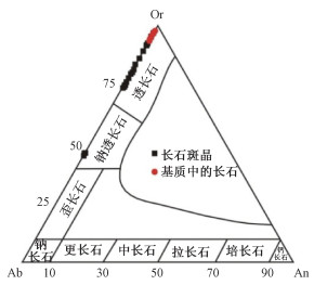
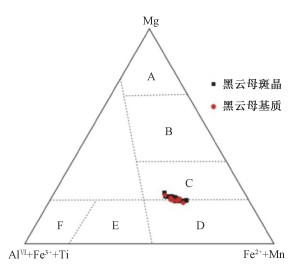
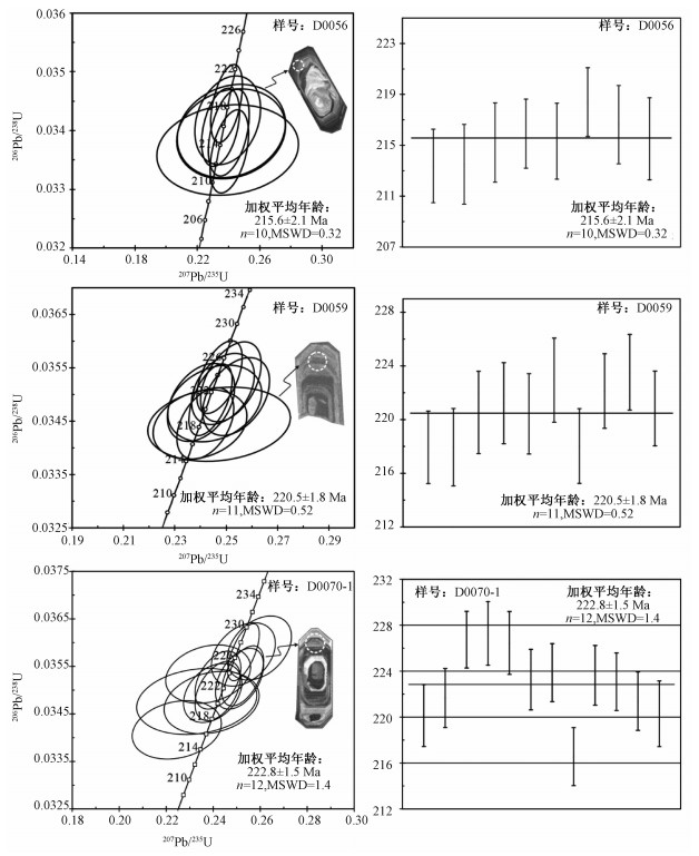
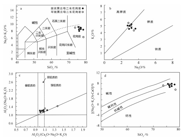
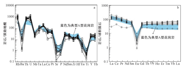
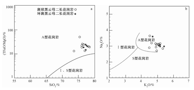
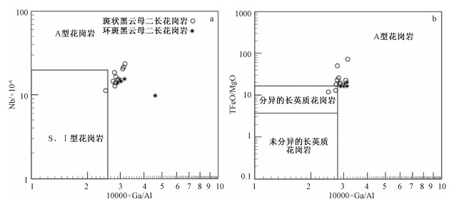
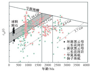
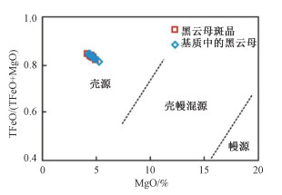
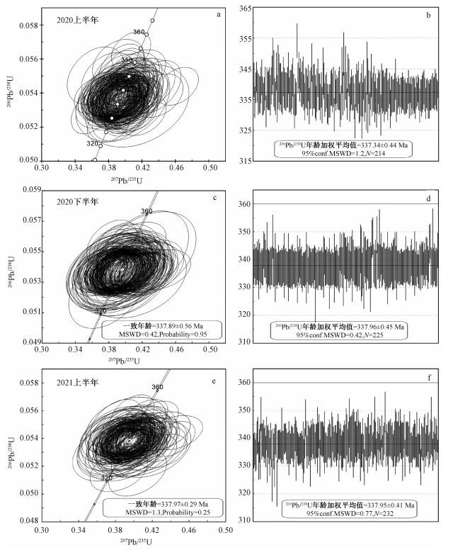
In this paper, zircon SHRIMP U-Pb geochronology, petrology, mineral chemistry, petrogeochemistry, Sm-Nd and Lu-Hf isotopes were studied for the eastern part of the Dupangling pluton, which is located at the western section of Nanling at the junction of Hunan and Guangxi provinces. The zircon SHRIMP U-Pb dating results show that the age of coarse-to-medium-grained porphyritic biotite monzogranite is 215.6±2.1 Ma, medium-grained porphyritic biotite monzogranite 220.5±1.8 Ma, medium-grained rapakivi biotite monzogranite 222.8±1.5 Ma. Combined with the age of fine-grained muscovite monzogranite as 209.7±3.1 Ma obtained in the previous research, it is suggested that the emplacement time ranges from 222.8 Ma to 209.7 Ma, and the pluton is derived from the Indosinian magmatic activity rather than the Yanshanian as previously thought. The mineral-chemical characteristics of rapakivi K-feldspar and biotite phenocryst indicate that the magma temperature, pressure and composition have gone through fluctuation during the formation process, and biotite phenocryst was formed by multiple melting under the underplating by basaltic magma in this area. The Dupangling biotite monzogranites have higher contents of SiO2 and K2O+Na2O, A/CNK value ranges between 1.02 and 1.39 and Rittman index (δ) between 0.93 and 2.18, belonging to the peraluminous calc-alkaline. Moreover, these monzogranites are enriched in REE, Rb, Th and U with higher content of HFSE (Nb, Y and Ga), depleted in Ba, Sr and Eu with higher ratios of TFeO/MgO and Ga/Al, showing the characterisitics of A-type granite. The isotope εNd(t) value ranges from -8.74 to -8.13, and the T2DM value from 1.71 to 1.66 Ga; the zircon isotope εHf(t) value ranges from -14.1 to -1.4, and the T2DM value from 2.14 to 1.34 Ga. It reveals that the Dupangling biotite monzogranites mainly originated from the partial melting of ancient crustal materials and were mixed with a certain degree of depleted mantle materials. The metamorphic peak period of the Indosinian movement is from 258 Ma to 243 Ma. South China was in an extensional tectonic setting after 233 Ma and mantle-derived basalt magma was in a wide range of underplating, which caused the crustal material remelting to form the Dupangling Indosinian aluminous A-type granite (rapakiwi granite) under an extensional background.
In-situ zircon U-Pb dating method by LA-ICP-MS and discussions on the effect of different beam spot diameters on the dating results
WANG Sen, ZHANG Shuanhong, ZHANG Qiqi, LIANG Xia, KONG Linghao, HU Guohui, WANG Kai, WANG Hongyu, CAI Yuhang
2022, 28(4): 642-652. doi: 10.12090/j.issn.1006-6616.2021140
Abstract (1042) HTML (236) PDF (12757KB)(120)
Abstract:
By using the newly introduced GeoLas HD 193 nm ArF excimer laser ablation system and the Agilent 7900 quadrupole inductively coupled plasma mass spectrometer (ICP-MS) in the Key Laboratory of Paleomagnetism and Tectonic Reconstruction at the Institute of Geomechanics, we successfully established the in-situ zircon U-Pb dating method and trace element analytical method by LA-ICP-MS. U-Pb dating experiments were carried out on Plešovice, Temora1 and Qinghu zircons under the experimental conditions of 32 μm beam spot diameter, 5.0 J/cm2 energy density and 5 Hz denudation frequency using the standard zircon 91500 as the external standard. The ideal age results are consistent with their recommended values, and the measured U-Pb ages for Plešovice zircon remain stable in different periods. Meanwhile, a comparative study of the U-Pb dating results in different laboratories was carried out on an unknown sample 11-5, and the dating results are consistent with that obtained in the State Key Laboratory of Geological Processes and Mineral Resources at China University of Geosciences (Wuhan) within analytical error. Trace elements in zircon standard 91500 and glass standard NIST SRM 612 were analyzed by using NIST SRM 610 as an external standard and 29Si as an internal standard, and the measured values are consistent with the recommended values of trace element contents. In addition, the influence of different beam spot diameters on the zircon U-Pb age results was explored by using the Plešovice zircon as an example. The results show that a denudation diameter of 16~44 μm can obtain reliable zircon U-Pb ages similar to the recommended age, and under the same energy density and denudation frequency conditions, U-Pb ages obtained by using 32~44 μm beam spot diameters are more accurate than those obtained by 16~24 μm beam spot diameters.