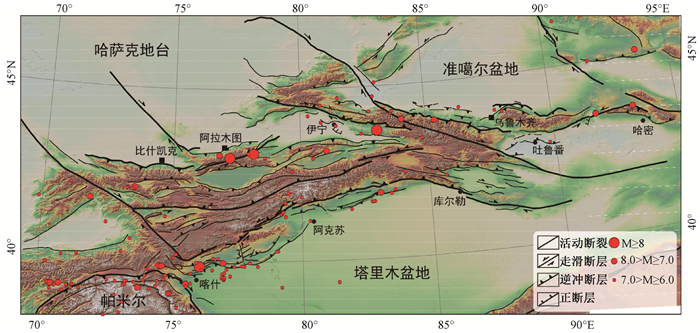
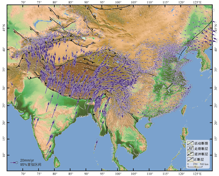
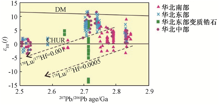
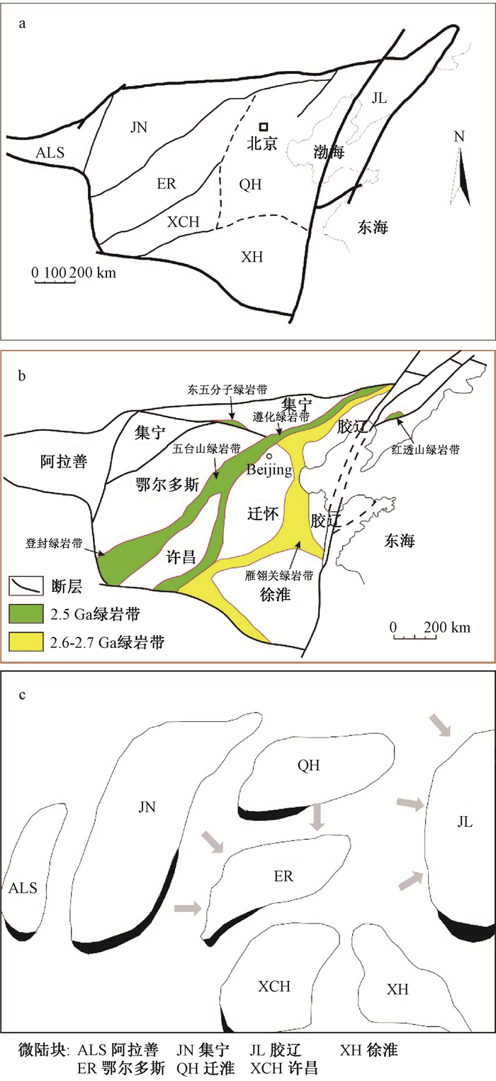
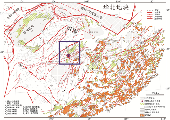
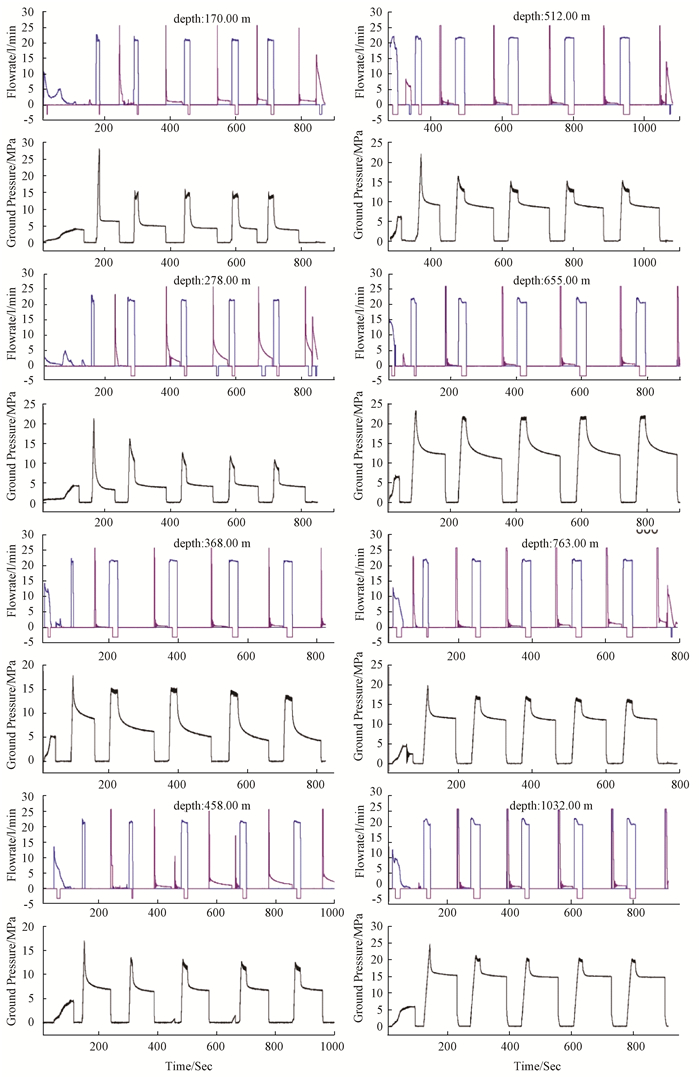
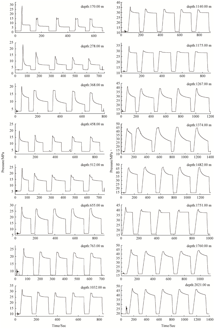
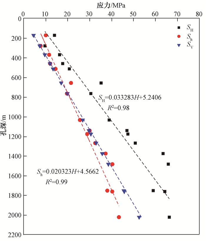
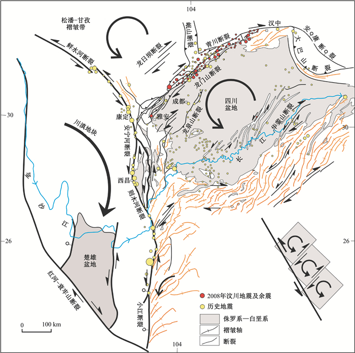
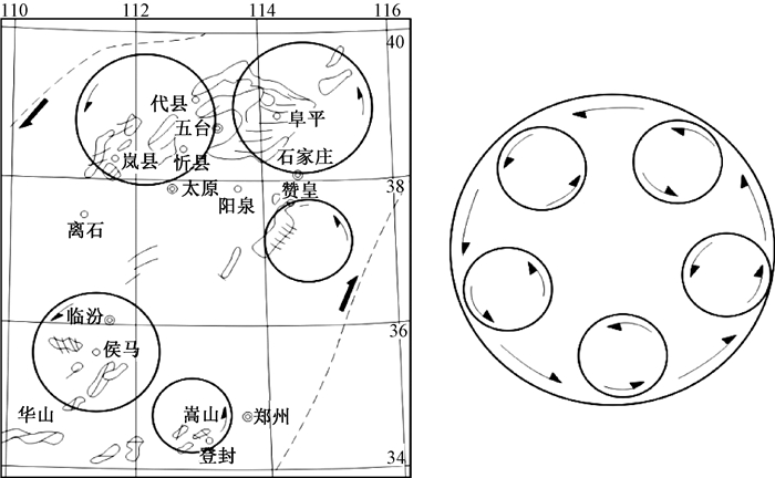
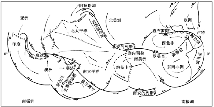
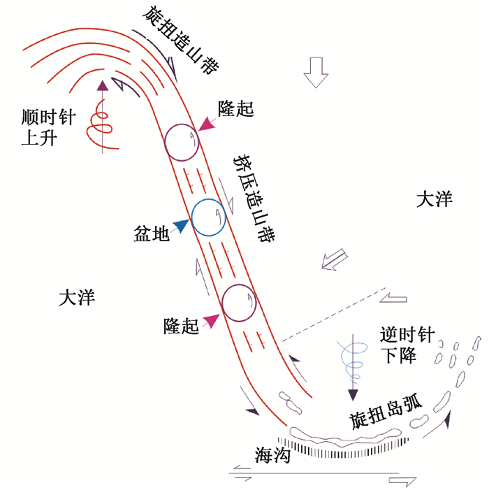
2019 Vol. 25, No. 5

Display Method:
Inside Cover
2019, 25(5): 封三-封三.
Abstract (137) PDF (34014KB)(13)
Abstract:
Inside Cover
2019, 25(5): 封二-封二.
Abstract (112) PDF (35390KB)(16)
Abstract:
Contents
2019, 25(5): .
Abstract (105) PDF (642KB)(10)
Abstract:
Cover Page
2019, 25(5): .
Abstract (90) PDF (1430KB)(14)
Abstract:
Chief Editor’s Address
2019, 25(5): 1-4. doi: 10.12090/j.issn.1006-6616.2019.25.05.081
Abstract (90) HTML (38) PDF (368KB)(12)
Abstract:
BASIC IDEAS OF THE MULTISPHERE TECTONICS OF EARTH SYSTEM
REN Jishun, NIU Baogui, ZHAO Lei, XU Qinqin, ZHU Junbin
2019, 25(5): 607-612. doi: 10.12090/j.issn.1006-6616.2019.25.05.058
Abstract (393) HTML (154) PDF (11642KB)(63)
Abstract:
The basic concepts of the multisphere tectonic view of the Earth system are to place the Earth as a living celestial body in the cosmic system, considering more about the interaction among the deep crust, mantle and core of the earth and the effect of the extraterrestrial celestial body on the Earth movement. This tectonic view holds that tectonic movement is not only the interaction between the lithospheric plates, but also the global dynamic process of the Earth system. The continent and the ocean are the unity of opposites and can be transformed into each other, and the conception of simple continental accretion should be regarded as invalid. The mantle convection hypothesis has not been confirmed so far, and the continental blocks are active, but they can't largely drift at random. The continental crust growth should not be thought to be achieved by simply lateral or vertical accretion, but the product of the multicyclic tectono-magmatism superposition. The tectonics of the Earth has not been developed by uniform changes, but by nonuniformitarian and nonlinear cyclic evolution. The Earth's surface layer has different tectonic patterns controlled by the corresponding deep fault systems in different geological stages, and the Atlantic-Indian-Pacific oceanic basin systems only emerged since the late Mesozoic.
EAST ASIA MULTI-PLATE CONVERGENCE IN LATE MESOZOIC AND THE DEVELOPMENT OF CONTINENTAL TECTONIC SYSTEMS
ZHANG Yueqiao, DONG Shuwen
2019, 25(5): 613-641. doi: 10.12090/j.issn.1006-6616.2019.25.05.059
Abstract (800) HTML (335) PDF (53639KB)(157)
Abstract:
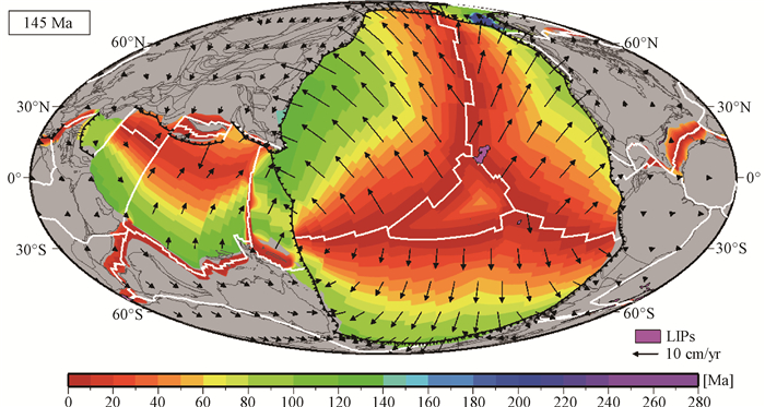
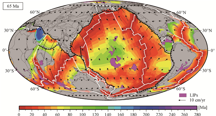
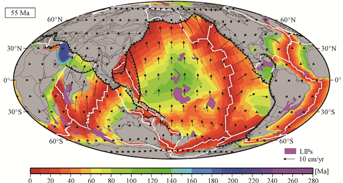
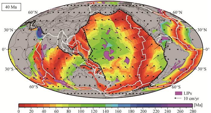
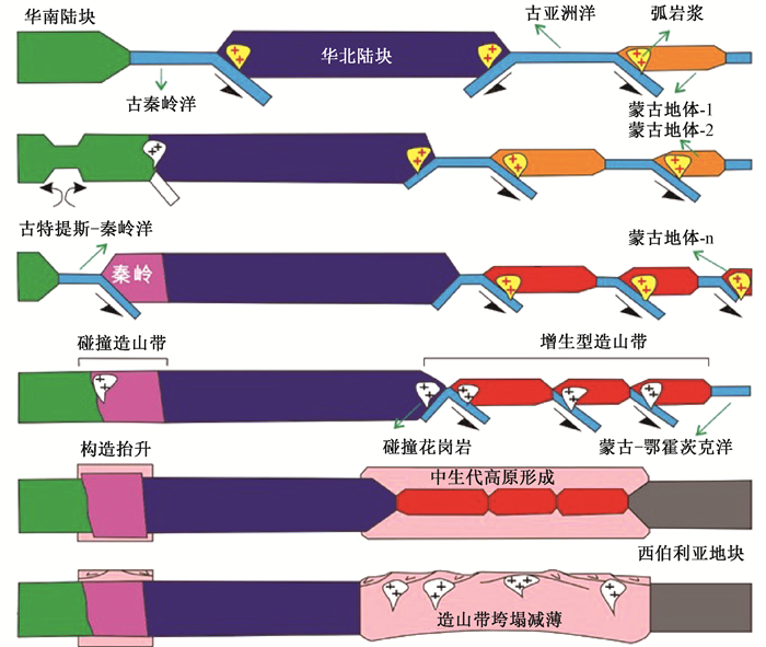
The proto-East Asia continent was build up through Triassic Indosinian orogenesis. Its surrounding three oceans, the Paleo-Pacific ocean to the east, the Mongolian-Okhstk ocean to the north, and the Meso Tethys to the southwest, were quasi-simultaneously subducted under this continent in the earliest Jurassic, which marked the beginning of a new tectonic era called East Asia multi-plate convergence history or for short East Asia convergence. In this paper, by integrating the recent research results of tectono-magmatic studies, we briefly describe the basic features of the three marginal tectonic belts generated by the East Asia convergence, i.e., the Mongolia-Okhstk collisional orogen along its northern margin, the subduction-related accretional orogens along its eastern margin, and the Bangonghu-Nujiang suturing zone along its SW margin, together with widely developed compressional and extensional structures and magmatism produced in the interior of the East Asia continent. A new chronology of the tectonic evolution history was established in which three distinct stages were separated. The Early Jurassic (200~170 Ma) was dominated by coeval landward subduction of the oceanic plates and the development of active continental margins and magmatic activity along the marginal zones. The Middle-Late Jurassic to Early Cretaceous (170~135 Ma) was characterized by the structural development of three marginal orogenic belts (subduction-related accretional and continent-continent collisional orogenesis) and intra-continental orogenic zones, which, as a whole, formed the East Asia convergent tectonic system. The Middle-Late Cretaceous (135~80 Ma) was predominated by crustal extension and lithospheric thinning, with the development of continental extensional tectonic system in East Asia, due in part to the demise of the Mongolia-Okhstk orogeny, and in part to the retreat and/or break off of subducted oceanic slabs of the paleo Pacific Plate. We consider that the sequential evolution and deep-seated processes of Late Mesozoic multi-plate convergence in East Asia not only created complex marginal and intracontinental orogenic tectonic systems, but also controlled the explosive magmatism and mineralization in east China, meanwhile it caused seesaw change of landform in east-west direction. High plateaus possibly generated in East Asia during the middle-Late Jurassic to early Cretaceous convergent orogenesis may have been collapsed during the late-stage extensional tectonism. Coeval with the break-up of the Pangean supercontinent, the East Asia convergence evolved stepwisely from East Asia to Eurasia, then on the way to a future supercontinent.
MESO-CENOZOIC TECTONIC EVOLUTION AND PLATE RECONSTRUCTION OF THE PACIFIC PLATE
LI Sanzhong, CAO Xianzhi, WANG Guangzeng, LIU Bo, LI Xiyao, SUO Yanhui, JIANG Zhaoxia, GUO Lingli, ZHOU Jie, WANG Pengcheng, ZHU Junjiang, WANG Gang, ZHAO Shujuan, LIU Yongjiang, ZHANG Guowei
2019, 25(5): 642-677. doi: 10.12090/j.issn.1006-6616.2019.25.05.060
Abstract (1147) HTML (297) PDF (138620KB)(243)
Abstract:
The Pacific Plate is the largest oceanic plate on the Earth since Mesozoic, but its original mechanism, structure and tectonic evolution are still unclear. The complexity of the interior of the Pacific Plate has not been taken seriously. Large igneous provinces, seamount chains, oceanic micro-blocks, continental micro-blocks and mantle micro-blocks in the deeper mantle in or under the Pacific Plate are well developed. The geodynamic implications of these complex intraplate or sub-plate structures need to be solved urgently. Based on the latest results of plate reconstruction, this paper attempts to analyze its kinematic process and to reveal the formation and evolution mechanism of the Pacific Plate. The results show that the Pacific Plate originated from the RRR triple junction, but it was not a pure oceanic plate. Its accretion and evolutionary processes have undergone a non-Wilson cycle model. Its margins have undergone the incorporation of some exotic continental or oceanic micro-blocks, and some new oceanic micro-blocks have involved and appeared in its interior for various reasons. It made the Pacific Plate show as a fragmented mosaic pattern. The Pacific Plate recorded important tectonic events interacting with the adjacent tectonic plates. At about 55 Ma, it began to subduct under the East Asian continental margin, resulting in a short NW-SE-directed extension of the East Asian continental margin, which was subsequently jointly controlled by the Indian-Eurasian collisional dynamic system and the Pacific subduction dynamic system, and generally formed some pull-apart basins under the right-lateral dextral strike slipping. Then due to subduction retreat, this region gradually developed a double subduction system. The Pacific Plate also recorded the deep-shallow coupling process, and the Pacific LLSVP in the lower mantle played a decisive role in the distribution of the upper lithospheric micro-plates and large igneous provinces. In addition, volcanic chains or hotspots not only reveal plate movement, but also reflect the process of material exchange between deep and shallow parts, and seamounts also reveal the mantle flow under the Pacific Plate. The mantle circulation is not a single convective cell, and the diversity of its convective pattern needs to be further studied.
CRUSTAL TECTONIC FRAMEWORK OF CHINA AND ITS FORMATION PROCESSES: CONSTRAINTS FROM STUCTURAL DEFORMATION
LI Jinyi, ZHANG Jin, LIU Jianfeng, QU Junfeng, ZHENG Rongguo, ZHAO Shuo, WANG Lijia, ZHANG Xiaowei
2019, 25(5): 678-698. doi: 10.12090/j.issn.1006-6616.2019.25.05.061
Abstract (466) HTML (107) PDF (128471KB)(111)
Abstract:
The crustal tectonic framework of China with its formation and evolution has been a major issue for geological field. However, almost all the available studies on this issue focus on tectonic division and evolution, but very few attentions are given to the deformation features and structural relation of various tectonic units in China. On the basis of comprehensive study of the existing data and the authors' research, this paper analyzes and summarizes the structural deformation and crustal tectonic framework of various regions such as South China, North China, Northeast China, Northwest China, Qinghai-Tibet plateau and Sulu-Dabie-Qinling, discusses tectonic division of some regions and put forward some new ideas which includes that there are same tectonic units on the two sides of the Songliao basin could be divided and correlated; that tectonic units in the West Junggar region were parts of the Kazakhstan paleoplate, and the ones in the East Junggar and northern East Tianshan belonged to the accretionary margins of Siberian Paleoplate; that the so-called Mudanjiang suture is not proved by available geological data; and that there are nearly EW- and NW-extended uplifts and depressions besides previous NNE-extensional ones in East China. And then, based on structural data, it briefly probes into the basement framework and formation age of North China craton, the formational age of the Yangtze and Tarim basements, amalgamation of North China, Yangtze and Tarim cratons and some other smaller blocks from Early Paleozoic through Triassic, Jurassic to Cenozoic, superposition and reworking of tectonic deformation in eastern China since Jurassic on the existing structures, and the formation of the current crustal tectonic framework of China
BASIC CHARACTERISTICS OF ACTIVE TECTONICS AND ASSOCIATED GEODYNAMIC PROCESSES IN CONTINENTAL CHINA
ZHENG Wenjun, ZHANG Peizhen, YUAN Daoyang, WU Chuanyong, LI Zhigang, GE Weipeng, WANG Weitao, WANG Yang
2019, 25(5): 699-721. doi: 10.12090/j.issn.1006-6616.2019.25.05.062
Abstract (539) HTML (171) PDF (92961KB)(183)
Abstract:
Many achievements and remarkable progress have been made in active tectonics in China, especially since the 1980s. These studies have laid a foundation for the quantitative study of active tectonics, based on a large number of extensive professional, targeted investigation and comprehensive research work. This paper reviews the research history of active tectonics and synthesizes a large number of previous studies, in order to summarize the basic characteristics of the active tectonics in continental China and its control over the regional geodynamic processes. The structural complexity generally results from the unique tectonic location. The modern crustal deformation is spatially various due to plate tectonics from different directions. On the whole, the geometric images of active tectonics in continental China are mainly composed of active tectonics of different properties and sizes controlled by regional faults. In this paper, we summarized the basic characteristics, geometric images and kinematic features, and the effects of these factors on earthquake. In addition, we also explore the regional geodynamic processes and modes in typical regions based on the general geodynamic characteristics of the continental China and the control of active tectonics on the tectonic deformation and strong seismic activities. Finally, combined with the development of new technologies and methods, the research directions and objectives in the future are illustrated.
TECTONIC EVOLUTION OF THE NORTH CHINA CRATON
ZHAI Mingguo
2019, 25(5): 722-745. doi: 10.12090/j.issn.1006-6616.2019.25.05.063
Abstract (1700) HTML (340) PDF (23287KB)(403)
Abstract:
The North China Craton (NCC) is a major tectonic unit of China. It is brought into focus to international Earth scientists, because of its complicated and complete geological records from Early Archean to Mesozoic. The tectonic evolution of the NCC can be classified into eight stages, which are as follows:Continental nuclei generation; Major growth of continental crust; Amalgamation of micro-blocks and cratonization; Great Oxygenation Event (GOE) and Paleo-Earth environment change; Paleoproterozoic mobile belt event and metamorphism of high-grade granulite facies; Proterozoic multi-stage rifting and Earth's Middle Age adjustment period; Paleozoic orogeneses along the margins of the NCC; Mesozoic tectonic regime inversion and de-cratonization. The tectonic evolution of the NCC as an example shows the Earth's irreversible evolution process with, specially, heat regime change. Although remaining controversial to mechanism of nuclei generation, it is undisputed that the continental crust grew from small to large in scale with multi-stages.~2.5 Ga cratonization is the most important event, and the amalgamation of micro-blocks is a fundamental process to accomplish stabilization. However, the amalgamation complied the dome-keel tectonic model (tectonic style of high-grade region and greenstone belt) is different from the Plate tectonics. After "the quiet period" during the Archean-Proterozoic boundary, the NCC recorded geological presentations of the Huronian Glaciation and GOE. The Paleoproterozoic mobile belt event includes rift-subduction-collision processes with metamorphism of high-grade granulite facies, indicating tectonic regime change from early heat tectonics to Early Plate Tectonics. The NCC was in an extensional tectonic setting over a long to 1.0 Ga critical epoch from~1.8 Ga to < 0.8 Ga, during which main geological activities included multi-stage rifting, multi-intracontinental magmatism and adjustment of lithosphere and texture between crust and mantle. The Paleozoic orogeneses occurred along the margins of the NCC, showing the tectonic activities between the Siberia, North China and South China blocks related to the Paleo-Mongolia Ocean and Paleo-Qinling Ocean. The Mesozoic tectonic regime inversion and basement reworking were shown by lithospheric thinning and a vast amount of crust-partial melting granites. The subduction of the Paleo-Pacific Ocean Plate to the NCC is considered as a main governing factor, but interaction with other circumjacent geological blocks are also considerable. The study on tectonic evolution of the NCC has global significance.
RETHINKING OF THE QINLING OROGEN
ZHANG Guowei, GUO Anlin, DONG Yunpeng, YAO Anping
2019, 25(5): 746-768. doi: 10.12090/j.issn.1006-6616.2019.25.05.064
Abstract (713) HTML (182) PDF (37346KB)(230)
Abstract:
To cherish the memory of geological pioneer J.S.Lee and think about the innovation development of Earth science and tectonic theory, the composite orogeny and dynamics of the Qinling orogen, based on further understanding of the fundamental characteristics of the Qinling orogen, is reconsidered. The Qinling orogen has so far experienced middle-small sized plates, multi-episode ocean-continent subduction, continent-continent collision and intracontinental orogeny, and eventually formed complex component and structure, and the continental composite orogen model of 4-D "overpass-type", rheological stratification, decoupling structure in dynamic evolution. As a result, the habitable Earth surface system and abundant natural resources serving the human society development and national needs have been created. Some issues on controversy are also briefly discussed for reconciling the insights on the Qinling orogen and deepening the study of continental composite orogen, and expecting to grasp J.S.Lee's academic essence for exploring continental tectonics and dynamics, developing plate tectonics theory and Geomechanics, studying Earth dynamics in the vision of the Solar system and universe and pushing the tectonic theory forward.
THE "CROSS-TECTONICS" IN CHINA CONTINENT: FORMATION, EVOLUTION, AND ITS SIGNIFICANCE FOR CONTINENTAL DYNAMICS
DONG Yunpeng, ZHANG Guowei, SUN Shengsi, ZHANG Feifei, HE Dengfeng, SUN Jiaopeng, LIU Xiaoming, YANG Zhao, CHENG Bin, HUI Bo, YUE Yuangang, ZHOU Bo, CHENG Chao, YANG Ziqiang, SHI Xiaohui, LONG Xiaoping
2019, 25(5): 769-797. doi: 10.12090/j.issn.1006-6616.2019.25.05.065
Abstract (370) HTML (160) PDF (24348KB)(157)
Abstract:
The East Asian continent is the most complex continent which was formed by amalgamation of many small-to-medium-sized Laurasia or Gondwana associated blocks. The China continent is located in the core position of East Asia, and is the key to study the formation and evolution of the East Asian continent. The most important tectonic framework controlling the formation and evolution of main China continent is the "cross-tectonics", that is, the EW trending Central Orogenic System and the NS trending Helan-Chuandian North-South tectonic belt. The former includes, from east to west, the Qinling, the Qilian and the Kunlun orogenic belts. They were formed by the subduction-collision between the southern and northern continental blocks during the Paleozoic-Indosinian period constituting the mainland of the China continent. Then, Central Orogenic System has been overprinted by the Mesozoic to Cenozoic intracontinental orogenic events, forming the north and south division of geological geography, ecological environment, and human economy. The latter inherited the Precambrian plate tectonic records, and was gradually transformed into the continental margin of the Paleo-Asian Ocean or Paleo-Tethys tectonic domain. Due to the Neo-Tethys tectonic evolution, it was evolved into the eastern boundary of the uplift and expansion of the Tibetan Plateau, controlling the late Mesozoic-Cenozoic reverse evolution of the western and eastern China. With "cross-tectonics" as the coordinate system, the four quadrants of China mainland have distinct characteristics of geological and geophysical structure, resources, geomorphology, ecology, environment, culture and economy.
NEW UNDERSTANDING OF THE TECTONIC FRAMEWORK AND EVOLUTION DURING THE NEOPROTEROZOIC-PALEOZOIC ERA IN THE EAST TIANSHAN MOUNTAINS
WANG Guocan, ZHANG Meng, FENG Jialong, LIAO Qun'an, ZHANG Xionghua, KANG Lei, GUO Ruilu, XUAN Zeyou, HAN Kaiyu
2019, 25(5): 798-819. doi: 10.12090/j.issn.1006-6616.2019.25.05.066
Abstract (364) HTML (142) PDF (65194KB)(56)
Abstract:
Based on the new data obtained from the geological survey, the properties and temporal and spatial correlation of the Junggar-Tuha block, North Tianshan ocean basin and Kanggur ocean basin during the Neoproterozoic-Paleozoic era in the East Tianshan mountains are redefined. It is proposed that the Junggar-Tuha block is a relatively rigid unified block with the characteristics of oceanic plateau with juvenile crust of 0.8~0.55 Ga in depth and some>1.0 Ga old crust fragments on the surface. The northern boundary of the block changed with time as the evolution of its northern margin. Based on newly defining of the Dacaotan ophiolite and systematic carding of other ophiolites between the Junggar-Tuha block and the Middle Tianshan block, we suggest two stages of the oceanic basin evolution in the Paleozoic era to the south of the Junggar-Tuha block. The North Tianshan oceanic basin was developed in the earlier stage occurred in the Cambrian-Middle Devonian, representing the main oceanic basin which significantly separated the Junggar-Tuha block from the Middle Tianshan-Tarim plate for a long time. The Kanggur oceanic basin, however, is a small re-opened limited oceanic basin developed in the Carboniferous-Early Permian with a short duration which was superimposed on the sewn paleo-continental margin of the North Tianshan Ocean. Combined with other new research achievements in recent years, tectonic evolution model during the Neoproterozoic-Paleozoic in the East Tianshan mountains is reconstructed.
REDISCOVERING OF THE QINGHAI-TIBET-YUNNAN-BURMA-INDONESIAN η-TYPE STRUCTURE
ZHAO Yue, YAN Jiyuan
2019, 25(5): 820-826. doi: 10.12090/j.issn.1006-6616.2019.25.05.067
Abstract (226) HTML (138) PDF (32926KB)(49)
Abstract:
The Qinghai-Tibet-Yunnan-Burma-Indonesian η-type structure was gradually shaped from Middle Miocene when the earliest collision between the Australia plate and the Southeast Asia blocks began. This tectonic system has been formed since Early Pliocene with a unified deformation, motion and dynamical system. It belongs to a huge tectonic system with the serial vortex structures extending from southeastern Asia to Australia and the southwestern Pacific. Rediscovering of this tectonic system is because of that it is closely related to the tectonic geomorphic evolution of Tibet Plateau and the significant adjustment of the global ocean thermohaline current which caused to regional and even global climate change. To understand Professor J.S.Lee's scientific thought and his tectonic system theory needs to think and explore from a broader scope and the frontier of scientific development along the essence of his thought.
TECTONIC ARCHITECTURE AND EVOLUTION OF THE EASTERN SICHUAN-WULINGSHAN AREA, SOUTH CHINA
WANG Zongxiu, LI Chunlin, LI Huijun, ZHANG Linyan, LIANG Mingliang, TAN Yuanlong, LI Leilei, LI Tao, GAO Li, GUO Yongyan, LIU Yanjiao, YAN Xili
2019, 25(5): 827-839. doi: 10.12090/j.issn.1006-6616.2019.25.05.068
Abstract (340) HTML (406) PDF (61967KB)(58)
Abstract:
Intracontinental deformation is one of the important contents in continental dynamics research. The eastern Sichuan-Wulingshan area is located in the interior of the Yangtze Block, far away from the plate boundary, which is an excellent place to study the intracontinental dynamics. On basis of kinematic analysis of faults, morphological analysis of the folds, and contact relationship of the sedimentary strata in the field, we established the Phanerozoic tectonic architecture and discussed the multiple evolutions of the eastern Sichuan-Wulingshan area. Two tectonic events since the Late Mesozoic have laid the tectonic framework of the study area. The fold deformation differences of the eastern Sichuan-Wulingshan area were fundamentally controlled by the depth and quantity of decollement layers. Folds and faults were formed at the same time. The ridge-like folds in the eastern Sichuan area were the result of single-layer slip deformation, while the fold structures in the Wulingshan area were the result of the exposure of folds at different structural levels by different uplifts and denudations under the multi-layer slip background. Combining with the regional evolution, we proposed a five-stage tectonic evolution model of the eastern Sichuan-Wulingshan area in the Phanerozoic. The first three stages (Late Silurian-Middle Devonian, the end of the Carboniferous, and the Middle-Late Triassic) were dominated by regional uplift, without any folds. Then, large-scale folds and thrusts were developed at the fourth stage in the Late Jurassic-Early Cretaceous. Ultimately, due to the influence of the convergence of the India continent and Eurasia continent, the slip direction of the fault was reversed and the early structure was strongly reformed in the late Cenozoic.
PARTICLE-BASED MODELING OF CRACK PROPAGATION DURING PULL-APART BASIN DEVELOPMENT
LIU Yuan, KONIETZKY Heinz
2019, 25(5): 840-852. doi: 10.12090/j.issn.1006-6616.2019.25.05.069
Abstract (261) HTML (84) PDF (21141KB)(21)
Abstract:
Pull-apart basins are extensional structures which are closely related to strike-slip faults. Pull-apart basins have received considerable attention from geologists because of its significant tectonic meaning and the associations with volcanism, earthquake swarms, and special mineralization. Although numerous studies have contributed to the current understanding of pull-apart basin evolution, pull-apart basin development concentrating on crack propagation and coalescence is lacking because of the limitations of the previous methods. A particle-based approach, which is based on Discrete Element Method (DEM), can be successfully used to simulate crack propagation during pull-apart basin development for pure strike-slip. Transtensional models are also set up to investigate basin development and crack propagation in transtentional systems, with different angles between the master strike-slip faults and the motion direction in each system. Modeling results are compared with natural examples worldwide such as the Dead Sea basin, Cinarcik basin in Marmara Sea, and El Paraiso basin in SW Colombia et al. This research provides new method and view to study the evolution of pull-apart basins and the propagation and coalescence of the related strike-slip faults.
HYDRAULIC FRACTURING STRESS MEASUREMENTS IN XUEFENGSHAN DEEP BOREHOLE AND ITS SIGNIFICANCE
CHEN Qunce, SUN Dongsheng, CUI Jianjun, QIN Xianghui, ZHANG Chongyuan, MENG Wen, LI Awei, YANG Yuehui
2019, 25(5): 853-865. doi: 10.12090/j.issn.1006-6616.2019.25.05.070
Abstract (274) HTML (97) PDF (31658KB)(33)
Abstract:
By use of the recently developed hydraulic fracturing in situ stress measurement system, valid data of 16 depth intervals at the borehole depth range of 170~2021 m in the Xuefengshan deep borehole were obtained, which are the first reported results obtained at the borehole depth deeper than 2000 m in China. The test results showed that the magnitude of the in situ stress increased with the depth of the borehole. By linear regression, the relationship of the maximum and minimum horizontal principal stresses with the depth of the test borehole respectively are SH=0.03328H+5.25408, and Sh=0.0203H+4.5662, and at the borehole depth of 2021 m, the magnitude of which are 66.31 MPa and 43.33 MPa respectively. Based on the hydraulic fracturing test data, combined with the BHTV and borehole temperature logging test results, the analysis on the stress state of the study area were carried out. In the range of 170~800 m borehole depth, the relationship of the three principal stresses are SH > Sh > Sv, which are favourable for reverse faulting; In the range of 1000~2021 m borehole depth, the relationship changes to SH > Sv > Sh, which implied that the deep stress regime of this area are strike-slip faulting. The direction of the maximum horizontal principal stress is in NW~NWW direction. According to Mohr-Coulomb criterion, the activity of the faults of the study area were discussed and the conclusion were obtained that the faults of this area are in stable state.
SIGNIFICANCE AND ROLE OF IN-SITU CRUSTAL STRESS MEASURING AND REAL-TIME MONITORING IN EARTHQUAKE PREDICTION RESEARCH
TAN Chengxuan, ZHANG Peng, LU Shilong, ZHU Jianzhu, FENG Chengjun, QIN Xianghui, MENG Jing
2019, 25(5): 866-876. doi: 10.12090/j.issn.1006-6616.2019.25.05.071
Abstract (263) HTML (94) PDF (22229KB)(28)
Abstract:
When the Lushan Ms 7.0 earthquake occurred on April 20, 2013, Chinese scientists were not surprised and at a loss what to do as the Wenchuan Ms 8.0 earthquake happened in 2008. The main reason is that a lot of scientific research works have been carried out along the Longmenshan fracture zone after the Wenchuan Ms 8.0 earthquake, and the potential seismic risks have been primarily pre-found at the southwestern segment of the Longmenshan fracture zone, especially, absolute big crustal stress magnitude abnormality from in-situ crustal stress measuring and relative crustal stress short-term precursory abnormal variation from in-situ crustal stress monitoring have been discovered. This paper first briefly introduces the international main views and knowledge on earthquake prediction. Then the inspiration from the bore-hole strain monitoring result of 2004 Parkfield earthquake is discussed. The role and knowledge of crustal stress on earthquake prediction are also summarized. At last, the practice and exploration of in-situ crustal stress measuring and real-time monitoring in earthquake prediction are presented in detail. From the practice and facts, we think that earthquake prediction should be explored and studied, and in-situ crustal stress measuring and real-time monitoring is one of the effective ways for earthquake prediction.
INCISED VALLEY OF LAST GLACIAL MAXIMUM STAGE IN THE DRILLING STRATA ON THE TIANJIN-HEBEI COASTAL PLAIN
WANG Qiang
2019, 25(5): 877-888. doi: 10.12090/j.issn.1006-6616.2019.25.05.072
Abstract (158) HTML (69) PDF (33717KB)(17)
Abstract:
This paper reviewed the Prof. J.S. Lee's speech on how the Last Glacial Stage climate affected the environment in 1965, as well as the discovery process of the incised valley of the Last Glacial Maximum(LGM)Stage in the drilling strata on the Tianjin-Hebei coastal plain over 40 years. In the source-to-sink processes, at least since Late Pleistocene the study area had been the palaeo-Huanghe (Yellow) River sedimentary area, and the bottom of incised valley of LGM which had been found at many sites were generally at the depth of 30~32 m, lower than that of 20 m of the common Holocene series in the study area. Compared with the depth of 62 m of LGM incised valley in the Changjiang (Yangtze) River estuary area, the range of LGM incised valley in the study area was not as large as the former and there was no unified large estuary. The farthest LGM incised valley occurred at the north urban area of the Mengcun Hui autonomous county of Hebei Province, 80 km from the present coastline, i.e. the top of the Huanghe(Yellow)River sub-delta lobe in Western Han Dynasty. At the same time, the rapid deposition of Early Holocene happened at some drilling holes. It appears that in the study area, only the tributaries of palaeo-Huanghe (Yellow) River could provide such abundant supply, which partly supported the happening of Early Holocene transgression at some areas.
ON THE LANDFORM SIEVE AND RESTORATION: INHERITANCE AND INNOVATION OF J.S.LEE'S ACADEMIC THOUGHTS
ZHANG Ke
2019, 25(5): 889-898. doi: 10.12090/j.issn.1006-6616.2019.25.05.073
Abstract (207) HTML (82) PDF (7906KB)(16)
Abstract:
The academic system of J.S.Lee is extensive and profound; his scientific thinking is distinctive and original; and his research method is comprehensive and systematic, many of which are still worth inheriting and further innovating. One of the highlights here is the geological structural sieve. The definition of structural sieve is a method of the separation of the overlap structures formed in different periods by the analysis of the relative forming order. This idea is very important especially in the study of complex tectonics, avoiding possible confusion of the different geological structures with different ages. The idea is also valuable in the study of landforms, especially in the complex and overlap ones with different ages. Geomorphology is a four-dimension discipline. It is necessary to study not only the landforms in three-dimension in space, but also the geomorphic past, present and future in the time-dimension. In the research on geomorphologic time-dimension or historical geomorphology, we need to sieve different landforms with different ages in order, together with their forming agents, from the overlap or mosaic landform complex, restore their original features, reestablish their evolution history and analyze their genesis. Along the time-dimension masterstroke, methods and significance of research on geomorphic history, evolution and mechanism are exemplified by several macro-landforms (river systems, planation surfaces, late Mesozoic granite domes, K2-E red bed basins and late Quaternary basins, etc.) in the coast area of South China. In spite of various types, mosaic ages, complex genesis of the landforms in the example area, they show a harmonious picture by the research following the method of landform sieve and restoration. The example indicates that the landform sieving is the same efficient to the structural one. The research of historical geomorphology as well as the relationship between inheritance and innovation is discussed philosophically finally. The best way in the memory of J.S.Lee is to inherit his scientific thinking instead of his special knowledge, which was inevitably limited by the scientific and technological developing level in the past. The purpose in the memory of J.S.Lee is to encourage the original innovation in the scientific research for Chinese scholars by learning from his thinking quintessence.
SOME IMPORTANT ISSUES IN THE STUDY OF GRANITE TECTONICS
WANG Tao, GUO Lei, LI Shan, WANG Xiaoxia, WANG Chaoyang
2019, 25(5): 899-919. doi: 10.12090/j.issn.1006-6616.2019.25.05.074
Abstract (259) HTML (77) PDF (11093KB)(55)
Abstract:
In the universe only the Earth develops granitic rock, which is the most important component of the continent. Therefore, granite plays an important role in solid earth science research. In this regard, the author proposes the basic research content of granite tectonics can be summarized as physical characteristics (structure), material composition (rock geochemistry) and chronology. Based on the existing preliminary discussion, this paper further elaborates the following research advances, problems and development directions:granite rock association and its tectonic setting and environment determination; granite evolution and its tectonic environment (structural process); tectonic dynamics of granite deformation and intra-shell rheology; the deep source mapping of granite and the growth of the orogenic belt and crust. Granite tectonics is to explore the problem of tectonics from the perspective of granite, and it enriches the content of geotectonic research. It is necessary for the interdisciplinary and integrated development of geoscience today.
GENETIC LINK BETWEEN LARGE IGNEOUS PROVINCES AND LARGE VOLUMES OF BLACK SHALE DEPOSITION AND ITS IMPLICATIONS
ZHANG Shuanhong, PEI Junling, HU Guohui, ZHANG Qiqi, SHUI Guohao, ZHAO Yue
2019, 25(5): 920-931. doi: 10.12090/j.issn.1006-6616.2019.25.05.075
Abstract (370) HTML (77) PDF (41287KB)(57)
Abstract:
Large igneous provinces (LIPs) have a significant influence on global climate changes and mass extinction events. Previous results show that some of the Global Boundary Stratotype Section and Points (GSSPs) in the Phanerozoic international geologic time scale are corresponding to the coeval global-scale LIPs, mass extinction events and/or ocean anoxic events (OAEs) represented by black shales. However, due to limited knowledge of atmospheric oxygen concentrations, ocean redox conditions and early fossils during the Meso-Neoproterozoic Era prior to the Ediacaran period, little is known on the climate and environmental effects of LIPs and link between LIPs and black shales during a billion years in "Earth's Middle Age" (or "Boring Billion") from 1800 Ma to 800 Ma. Recent results on global distribution of the~1380 Ma LIPs and black shales indicate a temporal and genetic link between the~1380 Ma LIPs and black shales in the Columbia (Nuna) supercontinent. The~1380 Ma LIPs are widely distributed in Baltica, North America, Greenland, Siberia, Kalahari, Congo, West Africa, Amazonia, East Antarctica and West Australia; the coeval black shales have been identified in North China and Northern Australia Graton, and probably in Siberia, Brazil and India Cratons. We proposed that the~1380 Ma black shales were deposited in an and/or several large marine basins, not some restricted basins as previously regarded. Comparisons of the baddeleyite/zircon U-Pb ages of~1380 Ma LIPs and zircon U-Pb ages of tuffs from the black shales within the Xiamaling Formation indicate that global deposition of the~1380 Ma black shales are related to an oceanic anoxic event induced by environment effects of the~1380 Ma LIPs, and the coeval black shales and LIPs provide a robust natural marker for the Calymmian-Ectasian boundary at 1383 Ma. Preliminary results on global distribution of other Meso-Neoproterozoic LIPs and black shales suggest that several other stages of LIPs in "Earth's Middle Age" are correlated with coeval black shales and can potentially provide more natural markers for the Meso-Neoproterozoic geological time scale.
GEOCHRONOLOGY, GEOCHEMISTRY AND HF ISOTOPES OF VOLCANIC ROCKS IN PINGXIANG AREA, SOUTHWEST GUANGXI: IMPLICATIONS FOR THE LATEST STAGE OF PALEO-TETHYAN OCEAN NORTHWARD SUBDUCTION
LI Zhenglin, LIU Xijun, XIAO Wenjiao, BAO Houyin, SHI Yu, LIU Lei, LIAO Shuai, QIN Xianzhu
2019, 25(5): 932-946. doi: 10.12090/j.issn.1006-6616.2019.25.05.076
Abstract (245) HTML (86) PDF (29566KB)(26)
Abstract:
Pingxiang area located in the southwest margin of Souch China Block (SCB) and north side of the collision zone between the South China and Indochina plate, tectonically belongs to the eastern part of the Tethyan tectonic domain. The Triassic intermediate-acid volcanics exposed in the Pingxiang area are continental arcs formed during the subduction of the Paleo-Tethysan ocean. They carried a large number of captured zircons sourced from the basement of SCB, which provided important information for the tectono-thermal events in SCB. In this paper, the geochronology, geochemistry and zircon Hf isotope studies were carried out on the dacites from Triassic Beisi Formation in Pingxiang area, and a weighted average age yeild 227.8±1.3 Ma from one dacite sample was obtained, representing its crystallization age. Geochemically, the dacites have high contents of SiO2, K2O, and low MgO, MnO and CaO contents, enriched in LILEs (Rb, Ba, Th and U) and depleted in HFSEs (Nb, Ta), which shows a typical characteristics of island arc magma, representing the continental arc products formed by the northward subduction of the Paleo-Tethysan ocean. The U-Pb age frequency distribution of captured zircons from another two dacite samples is mainly concentrated in (1)1010~800 Ma (peak 900 Ma), and the zircon εHf(t) value is 4.5~15.1, responding to the tectonic evolution events of the convergence-rifting-reconvergence between the Yangtze and Cathaysia blocks and the participation of the mantle-derived magma; (2) 720~620 Ma (peak 680 Ma), responding to the re-rifting of the Yangtze-Cathaysia blocks; (3) 490~400 Ma (peak 450 Ma), the zircon εHf(t) value is 2.2~-7.8, responding to the tectono-magmatic event of crust-mantle interaction related to the Caledonian movement in Early Paleozoic in SCB; (4) 280~230 Ma (peak 250 Ma), the zircon εHf(t) value is -13.6~-16.5, and the crustal model age is 2.3~2.1 Ga, which represents the magmatic event of the Paleo-Tethysan Ocean final subduction to closure between Indochina and South China. The study results reveal the dacites from Beisi formation have an intimate affinity with SCB, and its crystallization age constrains the latest time of the Paleo-Tethysan Ocean subduction ending to closure between SCB and Indochina block at least last to Middle to Late Triassic.
DEVELOP ACADEMIC THOUGHT OF J.S.Lee TO INITIATE NEW GEOLOGICAL CAUSE IN NEW ERA
ZHAO Wenjin
2019, 25(5): 947-955. doi: 10.12090/j.issn.1006-6616.2019.25.05.077
Abstract (199) HTML (92) PDF (30123KB)(19)
Abstract:
J.S.Lee is a good example and leading figure in the Chinese science and technology community. As a part of Chinese people's thought-house, his academic theory is of forward-looking significance and has a far-reaching influence. This paper discusses the main contents for the commemoration of J.S.Lee from the following five aspects:Mr. Lee has a pure heart for his country and people; He perseveres in the road of innovation and actively explores to solve China's problems; He emphasizes on practice and dialectical ideological methodology; He integrates theory with practice to address practical problems and develops Geomechanics; He vigorously cultivates academic leaders. It is suggested that his thought and spiritual wealth should be studied and carried forward to creatively deal with the new and important issues facing China and the world.
J.S.LEE, FOUNDER OF MODERN GEOLOGY IN CHINA: READING NOTES ON GEOMECHANICS
WANG Erqi
2019, 25(5): 956-961. doi: 10.12090/j.issn.1006-6616.2019.25.05.078
Abstract (579) HTML (150) PDF (23488KB)(25)
Abstract:
Mr. J.S.Lee is one of the founders of geology in China and he created geomechanics based on mechanics, with it different from the traditional geology, and since then, geology has moved from qualitative research to semi-quantitative and quantitative research. Academic views are different from one person to another, emphasizing that all flowers blossom together; however, his methods to propose, analyze and solve problems based on mechanics are universal, which has opened up the vision of later generations and influenced the subsequent studies of plate tectonics and continental tectonics. More importantly, although he added a wealth of modern scientific elements to geology, he still emphasized the cultivation of basic geological skills, the improvement of field observation and practice ability, the interdisciplinary and the accumulation of first-hand data, all of which are particularly valuable today.
RESEARCH ON TECTONIC DYNAMO-PETROGENESIS AND METALLOGENESIS AND TECTONOPHYSICOCHEMISTRY
LYU Guxian
2019, 25(5): 962-980. doi: 10.12090/j.issn.1006-6616.2019.25.05.079
Abstract (212) HTML (156) PDF (12743KB)(34)
Abstract:
The theory of "dynamo-petrogenesis and metallogenesis" was proposed in the early 1970s~1980s on the basis of research in the field of tectonogeochemistry such as stress minerals, rock deformation-metamorphism relation and structural control on ore. It represents a significant progress in the aspect of research on structural control on ore in geomechanics field. Applying "tectonic-lithofacies zone", i.e., the carrier of dynamo-petrogenesis and metallogenesis, great breakthroughs have been made in deep ore prospecting of the Shaertuohai chromite deposit, Xinjiang. Subsequent research has developed from the stage of "dynamo-petrogenesis and metallogenesis" to the present-day "tectonophysicochemistry" stage. Based on solid mechanics, research indicates that deformed rocks are formed by deviatoric stress field, which can be divided into differential stress and isotropic stress sections; the latter is named as "additional tectonic hydrostatic pressure". As a physicochemical variable, it can not only arouse rock volume variation but also can affect the chemical equilibrium. Combined with the long-term research on gold deposits in eastern Shandong, it was found that element geochemical distribution is a result of chemical equilibrium and physical chemistry is the cause of chemical action; accordingly, the thought of "The chemical equilibrium is affected by the change of pressure and temperature of tectonic forces" is proposed. The method of "structural correction based on ore-forming depth" has demonstrated the existence of the predicated "secondary enrichment zone" in gold deposits in eastern Shandong, promoting eastern Shandong to become the global third largest gold field from a crisis-mine severely afflicted area. Over more than 40 years' theoretical research, geological survey and prospecting practice, great progress has been made in tectonophysicochemistry. In 1996, the Professional Committee of Geomechanics set up the "Tectonophysicochemistry Professional Group". In 2018, "the Professional Committee of Tectonophysicochemistry" was approved by Chinese Geophysical Society.
PROGRESS IN RESEARCH ON ROTATION-SHEAR STRUCTURE
LI Dongxu, SONG Licai, ZHANG Linyan
2019, 25(5): 981-1000. doi: 10.12090/j.issn.1006-6616.2019.25.05.080
Abstract (189) HTML (71) PDF (51532KB)(31)
Abstract:
This paper reviews the history and progress of geomechanics research on rotation-shear structure in China. It also reflects the relevant research results abroad. J.S.Lee laid the theoretical foundation of rotation-shear structure through four theses. The subsequent research and ore-prospecting practice, as well as a variety of new methods for simulation tests and mechanical analysis, further enrich the research contents of rotation-shear structure, deepen the understanding on rotation-shear structure geometry, characteristics of kinematics and dynamics mechanism, proposing the idea that some rotation-shear structures are the results of spiral motion, and the formation of rotation-shear structure is likely to be related to the Earth rotation dynamics. Especially the success and economic benefit achieved in prospecting and exploration have improved the understanding on metallogenic theory. Finally, the paper puts forward the problems that should be paid attention to in the future study of the rotation-shear structure.
2019, 25(5): 1001-1002. doi: 10.12090/j.issn.1006-6616.2019.25.05.082
Abstract (81) HTML (25) PDF (1929KB)(28)
Abstract: