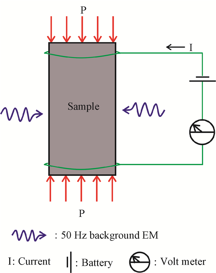
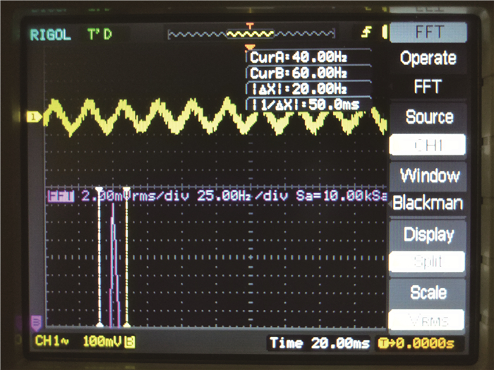
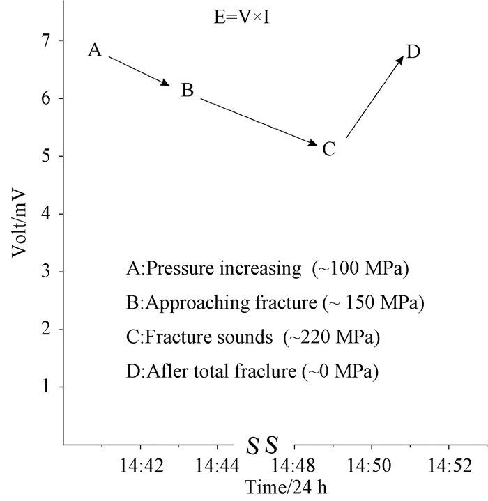
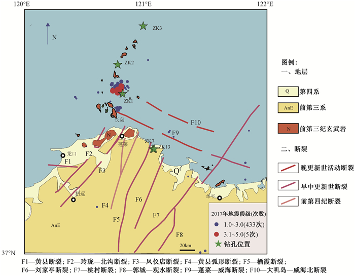
2019 Vol. 25, No. 4

Display Method:
Cover Page
2019, 25(4): . doi: 10.12090/j.issn.1006-6616.2019.25.04.001
Abstract (111) PDF (1390KB)(14)
Abstract:
Contents
2019, 25(4): . doi: 10.12090/j.issn.1006-6616.2019.25.04.000
Abstract (104) PDF (431KB)(6)
Abstract:
STRESS INDUCED CHANGES IN THE ELECTRICAL-MAGNETIC PROPERTIES OF ROCK CORESHUANG
HUANG Qiwen, LI Awei
2019, 25(4): 453-458. doi: 10.12090/j.issn.1006-6616.2019.25.04.042
Abstract (167) HTML (61) PDF (10521KB)(20)
Abstract:
The Standard Lattice Model predicts that under high stress, the outer most electrons of the Si-O bonds of a rock get ejected into the lattice's interstitial space. This loosely bound exoelectron cloud will, in a battery's electric field, have a direct current (DC) I; it will also absorb electromagnetic (EM) waves which result in an alternating current (AC) component in the induced current. Both effects have been measured. At high stress just before fracture, the DC current shows a slow rise due to electron tunneling followed by a sudden rise due to the breaking bond electrons. The AC current's voltage amplitude shows a drop as the current increases, and returns to normal after fracture when the current decreases to normal. This is the conservation of energy:absorbed wave energy E=V×I, AC current power. This AC fracture result demonstrates that EM waves can be used to actively probe the changes in highly stressed crust zones.
THE STATE OF THE IN-SITU STRESS AND FAULT STABILITY EVALUATION OF THE PENGLAI COAST
LI Bing, DING Lifeng, WANG Jianxin, HOU Yanhe, XIE Furen
2019, 25(4): 459-466. doi: 10.12090/j.issn.1006-6616.2019.25.04.043
Abstract (343) HTML (126) PDF (7022KB)(51)
Abstract:
In order to find out the in-situ stress state near the Penglai coast, hydraulic fracturing in-situ stress measurement was conducted in two boreholes (less than 200 meters in depth). The results were compared with the in-situ stress state of three boreholes off Changdao. Regression analysis was adopted to analyze the variation of in-situ stress with depth in this area. Fault stability in the study area was discussed combined with the ratio (μm) of maximum shear stress to average principal stress and lateral pressure coefficient(K'). The results show that the in-situ stress state of the Penglai coast is basically the same with that of Changdao, with the direction of the maximum horizontal principal stress being mainly NEE-EW which is consistent with the regional stress field in north China. The gradient of horizontal stress is greater than the average in-situ stress gradient of Bohai Rim. The relative magnitude of the three-dimensional principal stress in the shallow part of the study area is mainly SH > Sh > Sv which is conducive to the movements of the reverse faults. The values of both the study area and μm are high whose distribution intervals are 2.76~3.98 and 0.47~0.59 respectively. The land area faults and regional stress directions intersect at larger angles and are in a stable state; the angles between the NWW and NE faults of the sea area and the regional stress fields are smaller. If the regional stress continues to increase, it will be conducive to the movements of the strike-slip faults. This may be the primary reason for the frequent earthquakes of Changdao which is consistent with the fact that the focal mechanism of the earthquakes is mainly strike-slip. The research results are of great significance not only to the evaluation of fault stability in the study area but also to the design and construction of major projects.
STUDY ON THE VARIATION LAW OF CRUSTAL STRESS FIELD IN TIGHT RESERVOIR UNDER MULTI FIELD COUPLING
MENG Xianbo, XU Youde, ZHANG Yuejing, SHANG Fengkai, LI Jing, SUN Luning, ZHENG Haidong
2019, 25(4): 467-474. doi: 10.12090/j.issn.1006-6616.2019.25.04.044
Abstract (273) HTML (79) PDF (11615KB)(28)
Abstract:
Crustal stress is an important index of reservoir reconstruction scheme design and improvement to oil and gas exploration and development efficiency. Due to the complex environment in which tight reservoirs are located, the multi field coupling of temperature, stress and seepage should be considered comprehensively. Therefore, the tight reservoir in Block 4 three-dimensional area of central Junggar Basin was taken as an example, the THM coupled control equation was established based on the COMSOL Multiphyics software, and the variation law of crustal stress field in tight reservoir under multi field coupling was studied. The result shows that:The maximum horizontal principal stress ranges from 113 to 134 MPa, and the minimum horizontal principal stress from 106 to 124 MPa, all showing as compressive stress. In the process of oil and gas exploitation, the maximum horizontal principal stress increases first and then tends to be stable. With the deepening of oil and gas exploitation, the range of stress change gradually extends from the wellhead to the nearby fault, and preferentially develops along the fracture direction of the fault. In the fault transition zone, the stress value is minimum, and the stress at the core of the fault is between the broken transition zone and the continuous stratum. With the deepening of oil and gas exploitation, the vertical deformation will occur in tight reservoirs. The maximum vertical deformation of the reservoir occurs near the wellhead, the displacement is more than 10cm, and the settlement decreases as the distance increasing.
STUDY ON THE STRESS SENSITIVITY AND SEEPAGE CHARACTERISTICS OF TIGHT SANDSTONE BASED ON CT SCANNING
YANG Feng, WANG Hao, HUANG Bo, LI Xiaoqian, ZHANG Chao, XIAO Chunjin, LI Jing
2019, 25(4): 475-482. doi: 10.12090/j.issn.1006-6616.2019.25.04.045
Abstract (267) HTML (69) PDF (9054KB)(27)
Abstract:
The understanding of seepage characteristics of low-permeable reservoir is of great significant for oil and gas production and reservoir reconstruction. Therefore, the micro CT scanning technology was used to scan the tight sandstone samples so as to establish a microscopic model that can accurately reflect real structures of rock samples. COMSOL was used to simulate the seepage characteristics of fluid in the pores of rocks, and the seepage characteristics and stress sensitivity of tight sandstone were studied. The results show that:When the pressure difference between the inlet and outlet of the fluid is a constant value, the rock permeability remains unchanged and has no correlation with the specific value of the inlet and outlet pressure. The calculated permeability of rock models in different directions is in the same order of magnitude but slightly different. Under the action of lateral pressure, the flow path narrows, and the fluid overall velocity through the seepage path decreases, which leads to the decrease of permeability. However, where the pore is relatively large, the velocity rises slightly compared with that before the pressure is applied due to the narrowing of the path.
RESEARCH ON THE INFLUENCE OF THE COUPLING EFFECT OF SEEPAGE AND STRESS ON RESERVOIR FRACTURES
SONG Ziyi, WANG Hao, LI Jing, SUN Luning, ZHANG Jiatai, LIU Chen
2019, 25(4): 483-491. doi: 10.12090/j.issn.1006-6616.2019.25.04.046
Abstract (194) HTML (59) PDF (13425KB)(16)
Abstract:
Fracture is an important factor affecting the high and stable yield of reservoir, which lies in a complex geological environment. The formation and development of fractures are influenced by numerous factors; therefore, it is of great significance to study the effect of coupling among factors on reservoir fracture development for guiding petroleum exploration and development. In this study, the effect of seepage-stress coupling on fracture development of Wumishan Formation carbonate reservoir in Well Ren 11 area of Renqiu Oilfield is studied, and the results show that:Without considering the seepage-stress coupling effect, the maximum horizontal principal stress in the study area ranges from 82 MPa to 100 MPa, which gradually increases from southwest to northeast; the minimum horizontal principal stress ranges from 72 MPa to 88 MPa, which gradually increases from the center of the study area to the southwest and northeast. After considering the coupling effect, the maximum horizontal principal stress ranges from 84 MPa to 102 MPa, and the minimum from 76 MPa to 91 MPa. The horizontal principal stress increases after seepage-stress coupling is considered. After the coupling effect, fracture development index of the study area is mainly distributed between 0.027 and 1.156. The fracture development index of the top of the hilltop and the inner area of near the W-E fault is about 0.7, which is a relatively developed area, while the fracture development index of southwest and northeast marginal areas is less than 0.2, which is considered to be an underdeveloped area. With the increase of coupling time, the reservoir fracture development index increases gradually and it increases obviously in the area near the injection well and the oil production well. The fracture linear density of the whole reservoir also shows an increasing trend, only the fracture linear density around the oil production well shows a tendency to decrease first and then increase; The fracture parameters in the reservoir without consideration of coupling effect are smaller than that with consideration, which indicates that the results obtained from fracture prediction only based on stress field are on the small side.
A NEW METHOD FOR EVALUATING BRITTLENESS INDEX OF DEEP TIGHT SANDSTONE RESERVOIR
LIU Huimin, ZHENG Jinkai, ZHAO Wenshan, DU Zhenjing, LI Jing, WANG Hao
2019, 25(4): 492-500. doi: 10.12090/j.issn.1006-6616.2019.25.04.047
Abstract (312) HTML (105) PDF (6466KB)(27)
Abstract:
Reservoir rock brittleness evaluation is important foundation work for the design of reservoir fracturing reconstruction scheme, which has great influence on reservoir fracturing reconstruction effect. Taking the deep tight sandstone reservoir in the central part of the Junggar Basin as the research object, the rock triaxial test under 0~90 MPa multilevel confining pressure was carried out and the influence of confining pressure variation on brittleness rock was analyzed. In view of the unsatisfactory effect of the existing brittleness index on the evaluation of rock brittleness in target reservoirs, based on the energy conversion relationship in the stress-strain curve, a new brittleness index model, which includes the pre-peak brittleness index, post-peak brittleness index and the comprehensive brittleness index, is established. The results show that the confining pressure has a significant influence on the evaluation of rock brittleness; the pre-peak brittleness increases first and then decreases with the increase of confining pressure, while the post-peak brittleness and comprehensive brittleness decrease monotonously with the increase of confining pressure. The study shows that the brittleness of the reservoir gravel fine sandstone is poorer than that of the fine sandstone, and the brittleness difference is mainly manifested in post-peak brittleness.
OCCURRENCE GEOLOGICAL CHARACTERISTICS AND DEVELOPMENT POTENTIAL OF HOT DRY ROCKS IN QINGHAI GONGHE BASIN
ZHANG Shengsheng, ZHANG Lei, TIAN Chengcheng, CAI Jingshou, TANG Baochun
2019, 25(4): 501-508. doi: 10.12090/j.issn.1006-6616.2019.25.04.048
Abstract (584) HTML (204) PDF (13233KB)(63)
Abstract:
The Gonghe Basin is rich in hot dry rock geothermal resources. In order to enhance the theoretical understanding of the genesis of hot dry rock geothermal resources in the Gonghe Basin and further promote the exploration of hot dry rock resources, a comprehensive analysis of the genesis of hot dry rock resources in the Gonghe Basin is made from the heat source mechanism, caprock conditions and reservoir characteristics. Firstly, combined with regional geological structure analysis, geothermal geological survey, geophysical (aeromagnetic, earthquake) interpretation, four hot dry rock exploration wells with the depth of 2927-3705 m were drilled in the Gonghe Basin. At 3705 m, the high-quality hot dry rock resources of 236℃ were obtained, which was the first major breakthrough in the exploration of hot dry rock geothermal resources in China's non-modern volcanic areas. Secondly, radioactivities of granites from different depths were tested. The results show that the radioactive elements content of U, Th and K in the granitoids of the Gonghe Basin is slightly higher than the background value of the earth, and the radioactive heat generation rate is relatively low, the contribution of radioactive heat to the heat source of hot dry rock is less and the heat source may come from the melt in the Crust. Thirdly, based on geological data analysis and aeromagnetic interpretation, the potential hot dry rock distribution area of the Gonghe Basin is about 1.4×10⁴ km2. Finally, the volumetric method is used to evaluate the potential of hot dry rock resources in the Gonghe Basin. The results show that the total conservative and static amount of hot dry rock resources in the 3.0-6.0 km range of the Gonghe Basin is 8974.74×1018 J, and the converted standard coal can reach 306.619 billion tons, showing the broad prospects for development and utilization.
FRACTABILITY EVALUATION OF TIGHT SANDSTONE RESERVOIRS BASED ON IMPROVED ENTROPY ANALYTIC HIERARCHY PROCESS: TAKING THE JURASSIC RESERVOIRS OF WELL Z109 IN THE JUNGGAR BASIN AS AN EXAMPLE
SONG Mingshui, LIU Zhen, ZHANG Xuecai, WANG Yong, LI Jing, YANG Feiyue
2019, 25(4): 509-517. doi: 10.12090/j.issn.1006-6616.2019.25.04.049
Abstract (200) HTML (73) PDF (6798KB)(17)
Abstract:
Evaluation of reservoir fractability is an important basis for reservoir reconstruction, and the main factors affecting the fracability of tight sandstone are natural fracture, sandstone brittleness, horizontal stress difference, fracture toughness and so on. Taking Jurassic tight sandstones in Well Z109, Block 1, Central Junggar Basin as an example, four influencing factors, namely natural crack, sandstone brittleness, horizontal stress difference and fracture toughness, were considered comprehensively, and then improved analytic hierarchy process and entropy method were adopted to evaluate the fractability of tight sandstone reservoirs. The results show that the higher the fracturing index is, the easier it is to fracture tight sandstone reservoirs and the more complex fracture networks can be obtained during fracturing. The reservoirs with fracture index higher than 0.44, high brittleness, small fracture toughness, high degree of fracture development and low level difference coefficient are level Ⅰ high quality fracturing layers, and the reservoirs with fracture index higher than 0.44, high brittleness, small fracture toughness, low degree of fracture development and high level difference coefficient are level Ⅱ fracturing layers. In the study area, 4036~4039 m, 4062~4067 m, 4214~4218 m and 4260~4272 m of Well Z109 are level Ⅰ high quality fracturing layers, 4093~4108 m and 4284~4313 m are level Ⅱ fracturing layers. The research results provide scientific basis for fracturing reconstruction of tight sandstone.
THE MAIN CONTROLLING FACTORS AND EVOLUTIONARY SEQUENCE OF ORDOVICIAN FRACTURE IN H GAS FIELD OF BACHU UPLIFT, TARIM BASIN
LI Shubo, JIANG Wei, ZHANG Xiaogong, WANG Aixia
2019, 25(4): 518-526. doi: 10.12090/j.issn.1006-6616.2019.25.04.050
Abstract (204) HTML (70) PDF (16609KB)(8)
Abstract:
The Ordovician reservoirs in H gas field of Bachu uplift in Tarim Basin are carbonate reservoirs with low porosity and low permeability. The fracture system, as reservoir percolation channel, is characterized by complex spatial distribution and main control factors, and features of multi-stage superposition and evolution. Fracture development characteristics of Ordovician carbonate rocks in H gas field are analyzed by means of core description, microscopic observation and imaging interpretation, etc., major controlling factors of fractures are identified, and fracture evolution sequence is established. The results show that, the Ordovician system of H gas field in the Bachu uplift is dominated by shearing fractures, followed by tensional fractures, and tensional-shearing fractures are the least. The main controlling factors of fracture development are faults, folds and lithology, etc., and fault-related fractures are mainly developed within the range of 460 m from the fault. The higher the deformation degree is, the more developed the fractures are. Also the degree of fracture development is controlled by lithology. The larger the particle size or grain size of limestone are, the more developed the structural fractures are. According to the carbon and oxygen isotope test, combined with core observation, it is found that Ordovician tectonic fractures in H gas field have undergone at least three periods of evolution:development period of a small amount of low angle NEE and NNW trending shearing fractures in the middle of Caledonian; development period of medium-high angle NWW trending tensional fractures, NEE and NW trending tensional-shearing fractures, and SN and NE trending medium-high angle shearing fractures in late Hercynian; development period of a large amount of high angle NEE and NNE trending shearing fractures in early Himalayan, which is the main generation period of fractures.
ACCUMULATION CHARACTERISTICS AND ENERGY CONVERSION OF HIGH-SPEED AND LONG-DISTANCE LANDSLIDE ON THE BASIS OF DEM: A CASE STUDY OF SANXICUN LANDSLIDE
HU Xiaobo, FAN Xiaoyi, TANG Junjie
2019, 25(4): 527-535. doi: 10.12090/j.issn.1006-6616.2019.25.04.051
Abstract (333) HTML (121) PDF (18148KB)(37)
Abstract:
The velocity, accumulation characteristics and energy conversion are important factors in the study of the disaster-causing mechanism of high-speed and long-stance landslide; however, model test and field investigation can't fully reveal the mechanism. In this study, the landslide in Sanxicun was simulated by PFC3D to reveal that the velocity evolution distribution, accumulation characteristics and energy conversion relationship of frent, middle and rear rock and soil during the landslide movement process. The results show that, when the residual friction coefficient of Sanxicun landslide is 0.2, the simulation results are consistent with the actual accumulation characteristics. When the front, middle and rear rock and soil achieve peak velocity, the time distribution is Sfront < Smiddle < Srear. The velocity distribution of the front rock mass shows significant unimodal characteristic, while that of the rear rock mass is bimodal. The accumulation of rock and soil mass presents sequence distribution. In the transformation of gravitational potential energy of the landslide, friction energy accounts for 52% of the total energy, and only 15% of the gravitational potential energy at the peak of kinetic energy is converted into kinetic energy. The research results can provide reference for the analysis of the disaster-causing mechanism of high-speed and long-stance landslide and the project of disaster prevention and reduction.
APPLICATION OF HIGH-DENSITY ELECTRICAL METHOD IN LOESS-MUDSTONE INTERFACE LANDSLIDE INVESTIGATION
WANG Lei, LI Xiaobo, SU Zhandong, CHANG Chaoyu, PENG Da
2019, 25(4): 536-543. doi: 10.12090/j.issn.1006-6616.2019.25.04.052
Abstract (235) HTML (75) PDF (14232KB)(26)
Abstract:
Due to special geological conditions and regional geotectonic settings, several strong earthquakes occurred in Xiji county, Ningxia province in history, which induced a large number of loess-mudstone interface landslides, and brought serious threat to the safety of local people's life and property. Therefore, it is of great significance to explore the formation mechanism and risk assessment of loess-mudstone interface landslides by studying the formation structure, depth of bedrock and spatial distribution of such landslides. By using the high-density method, the stratum structure in the slope area was detected, and the survey results were validated by the bore hole columnar section. The observations of the resistivity well reflected the stratigraphy distribution. The loose and dry loess in the surface has high electrical resistance, and drops down with water content increases. The contact zone of mudstone and loess is saturated, which has low electrical resistance. This research proves that high density electrical method has good adaptability in loess-mudstone interface landslide investigation, which can provide reliable geophysical basis for further analysis of landslide mechanism and prevention.
RESEARCH ON RISK ASSESSMENT OF GEOLOGICAL HAZARDS IN QINLING-DABA MOUNTAIN AREA, SOUTH SHAANXI PROVINCE
ZHOU Jingjing, ZHANG Xiaomin, ZHAO Fasuo, LI Hui, LIU Hainan
2019, 25(4): 544-553. doi: 10.12090/j.issn.1006-6616.2019.25.04.053
Abstract (434) HTML (161) PDF (25115KB)(62)
Abstract:
Shaanxi Province is one of the provinces with the most serious geological disasters in China, especially the Qinling-Daba mountain area in south Shaanxi Province. Therefore, it is of great significance to conduct geological hazard assessment to guide disaster prevention and reduction. Taking Qinling-Daba mountain area as the study area, firstly based on GIS technology and the geological hazard data of the study area from 2001 to 2016, the sensitivity relationship between geological hazards and various index factors in the area is studied, and seven factors affecting the occurrence of geological hazards, such as elevation, type of rock and soil mass, fault structure and rainfall, are determined as the risk assessment indexes of regional geological hazards. Secondly, according to the number of geological disasters and the slope abrupt change of cumulative frequency curves under each index, the assessment index factors are graded into different states. Finally, the grid data model is established to carry out regional geological hazards assessment by using information value model. The results show that the percentages of high-risk, relatively high-risk, and medium-risk areas in the study area are 10.52%, 28.31% and 30.19%, respectively. The spatial distribution of geological hazards in the region is basically consistent with the hazard assessment results, and the prediction accuracy is 90.16%. This research combines empirical knowledge with data-driven analysis methods and applies to a wide range of geological hazard zoning. The conclusions provide reference for prevention and control of regional geological hazards.
ENGINEERING CHARACTERISTICS AND START-UP MECHANISM OF SLAG CLASTIC FLOW IN ZHAOCHUAN DISTRICT, XUANHUA
LI Xiaole, YANG Weimin, CHENG Xiaojie, ZHOU Junjie, ZHANG Shuxuan, WU Yutao, YU Hongkun
2019, 25(4): 554-562. doi: 10.12090/j.issn.1006-6616.2019.25.04.054
Abstract (177) HTML (97) PDF (21372KB)(7)
Abstract:
There are a large number of potentially dangerous loose slag accumulation bodies in Xuanhua area of Zhangjiakou. The representative Xiangshuigou loose slag accumulation bodies in the area is taken as the research object, and the laboratory tests are made on particle composition, mineral composition and mechanical properties. The test results show that the slag accumulation bodies belong to gravel sand with less clay content and poor gradation, loose and easy to flow. At the same dry density, the shear strength of slag increases first and then decreases with the increase of moisture content. When the moisture content is 15%, the cohesive force is the lowest, indicating that the limit moisture content of the slag accumulation bodies in Xiangshuigou may be around 15% at the beginning of the decline of instability. Based on the above analysis results, the formula of the relationship between cohesive force and water content is obtained by fitting, and the limit water content of the initial slide of clastic flow is predicted. This conclusion is of great significance to the stability evaluation of slag accumulation body and the early warning of clastic flow in this area.
THE SURROUNDING ROCK CONDITION EXPLORATION AND CONSTRUCTION METHOD ANALYSIS OF CROSS-BOHAI STRAIT PASSAGE
QIAO Erwei, PENG Hua, MA Xiumin
2019, 25(4): 563-573. doi: 10.12090/j.issn.1006-6616.2019.25.04.055
Abstract (236) HTML (51) PDF (16081KB)(12)
Abstract:
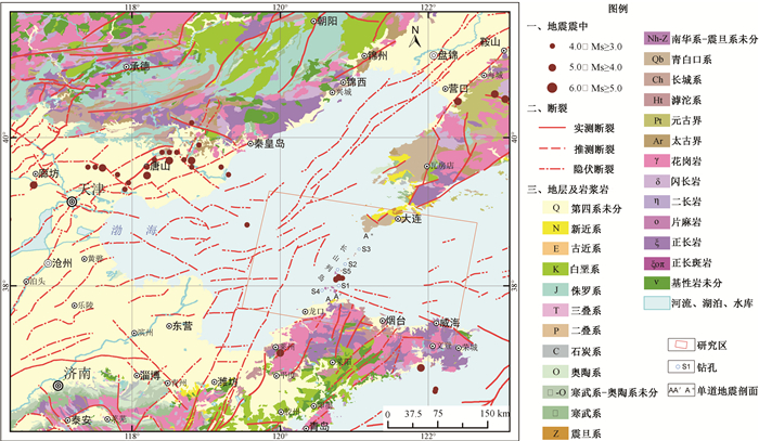
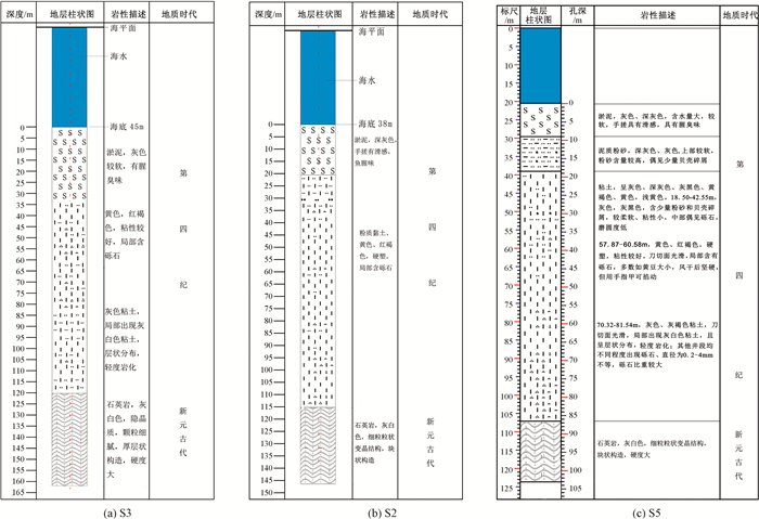
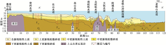
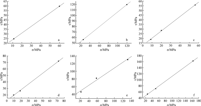
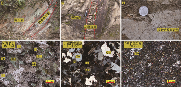
The cross-Bohai Strait passage is not only an important traffic and transportation project which connects Shandong Peninsula and Northeast regions, but it is also of vital significance for promoting the economic development of the Bohai-ring and revitalizing the northeast old industrial base. For the determination of the construction scheme of the project, it is necessary to analyze the surrounding rock conditions and the mechanical properties of the rocks. According to the regional geological survey, formation drilling in the sea area, stratum profile measurement of Bohai Strait and analysis of rock mechanics properties, it is shown that the exposed strata in the passage area are Quaternary, Neogene and Upper Proterozoic from top to bottom, respectively. The Quaternary strata is 10~120 m thick, which are mainly loose sediments, with no impermeable layers and poor stability. The Neogene rocks are scarcely found and scatter only in some areas. They mainly consist of macroporous basalts, and the mechanical properties index of basalts such as compressive strength is relatively low, even lower than normal values. The Upper Proterozoic is composed of quartzite and quartzite interbedded slate and phyllite. Quartzite is stable and hard, having a high compressive strength and shear strength, but slate and phyllite are soft rocks, which are easy to soften when exposed to water. Therefore, based on the two plans of "the whole tunnel" and "bridge in the South and tunnel in the North", it is suggested that the deep-buried tunnel method should be used in the "North Tunnel" section of cross-Bohai Strait passage, which means the tunnel should be located in the Upper Proterozoic quartzite under the Quaternary and Neogene strata. By the method for determining minimum buried of tunnel, the minimum depth of tunnel should be about 65m. In addition, due to the hardness of quartzite, the drilling-blasting method and TBM method should be adopted for the construction of cross-Bohai Strait passage.
ZIRCON U-PB AGE AND SOURCE CHARACTERISTICS OF NEOPROTEROZOIC GABBRO AND DYKES IN LONGWANGTANG REGION OF XIXIANG COUNTY, SHAANXI PROVINCE
ZHENG Guanggao, CUI Jianjun, LIU Xiaochun, CHEN Shaofeng, QU Wei, QIAO Jianxin, CHEN Longyao, ZHAO Wenping, LI Miao, LIU Lin
2019, 25(4): 574-589. doi: 10.12090/j.issn.1006-6616.2019.25.04.056
Abstract (225) HTML (58) PDF (27244KB)(12)
Abstract:
There exist a number of Jinningian magmatic rocks in Xixiang county, Shaanxi Province, which is an important "fingerprint" to study and understand the evolution of the Yangtze craton basement. This paper focuses on gabbro body, granite and albitophyre dikes from Longwangtang region, aiming to understand their formation ages and source characteristics through the methods of LA-ICP-MS zircon U-Pb dating and in-situ Lu-Hf isotope analyses. Age data show that gabbro and granite dike emplacement ages are (863.6±4.4) Ma and (863.6±3.8) Ma, respectively, suggesting they are the products of Neoproterozoic magmatism. Three age groups of (905.2±8.2) Ma, (807.0±8.9) and (762.5±4.2) Ma are identified in the two albitophyre dikes; The first group records the inherited zircon ages and the latter two groups represent emplacement ages for the two dikes, respectively. These results suggest that there existed three stages of magmatism (~864 Ma, ~807 Ma and ~763 Ma), and also existed an early tectonic-thermal event (~905 Ma), indicating Longwangtang region has undergone and preserved long-lived and multi-phased intrusive activities. Lu-Hf isotopic analysis shows that these samples have εHf(t) average values of +7.1~+10.0. Based on the comprehensive analysis of the available geological data, most εHf(t) values of Neoproterozoic rocks in Hannan are positive, showing the trend of deviating from depleted mantle line and closing to chondrite line with time in general, indicating the Neoproterozoic magmatic rocks of Hannan mainly derived from the partial melting of depleted mantle or juvenile crust in an active continental margin setting.
THE DISCOVERY AND GEOLOGICAL SIGNIFICANCE OF MID-CAMBRIAN GRANITES IN MAERYANG AREA, TASHKURGHAN MASSIF, WEST KUNLUN
LI Ruiqiang, HE Chengguang, CHEN Yonglin, YAO Shuai, WANG Kun, LI Lanlan
2019, 25(4): 590-606. doi: 10.12090/j.issn.1006-6616.2019.25.04.057
Abstract (266) HTML (102) PDF (13537KB)(10)
Abstract:
The paper reports a mid-Cambrian granitic magmatic activity which is comprised of gneissic granodiorite and monzogranite in Maeryang area of Tashkurgan massif, West Kunlun. LA-ICP-MS zircon U-Pb dating yields the emplacement ages of ca. (506.0±6.8) Ma and (514.0±9.3) Ma, respectively. The granites are characterized by moderate-high alkaline, quasi-aluminum to weak peraluminum, and a moderate range of SiO2 (67.83%~75.76%). Addtionally, the total REE of granites is equivalent to the average continental crust (∑REE=90.85×10⁻⁶~186.10×10⁻⁶) and marked by obvious fractionation between light and heavy REE ((La/Yb)N=5.38~22.43) and negative Eu anomalies(δEu=0.42~0.71). The intrusions have geochemical features of enrichment of LILEs such as Rb, K, Ba, Th, U and depletion of HFSEs such as Nb, Ta, P, Ti. The geological and petrogeochemical characteristics of the granites indicate that they are quasi-aluminous to weakly peraluminous highly fractionated Ⅰ-type granites. Zircon saturation temperature reflects that the mid-Cambrian granites can be assigned to the high-temperature magmatic rocks. The presence of mica-rich enclaves in the granites which were most likely derived from crust-mantle mixing magma indicates that the crust composition accounts for a large proportion. The intermediate acid magma intrusion during middle-late Cambrian in Tashkurghan and its adjacent region shows that there was a magmatic arc zone in the southern margin of Tashkurgan-Tianshuihai massif. The granites in Maeryang area might originate in the partial melting of ancient continental crust heated by upwelling and underplating mantle during the Proto-Tethys ocean northward subduction in mid-Cambrian. It also indicates that the tectonic environment and geodynamic background during the middle-late Cambrian period have taken a major turn after the Sinian-early Cambrian extension and cracking stage in the Tashkurgan area.