2019 Vol. 25, No. 3

Display Method:
Inside Cover
2019, 25(3): 封三-封三. doi: 10.12090/j.issn.1006-6616.2019.25.03.016
Abstract (149) PDF (7255KB)(13)
Abstract:
Inside Cover
2019, 25(3): 封二-封二.
Abstract (115) HTML (65) PDF (10488KB)(17)
Abstract:
Cover Page
2019, 25(3): .
Abstract (60) PDF (1464KB)(6)
Abstract:
Contents
2019, 25(3): .
Abstract (66) PDF (423KB)(7)
Abstract:
EARLY PALEOZOIC TECTONIC DEFORMATION IN QIASHENKANSAYIGOU AREA, NORTH ALTUN, AND IMPLICATION FOR TECTONIC EVOLUTION
WU Yu, CHEN Zhengle, CHEN Bailin, WANG Yong, MENG Lingtong, SUN Yue, HE Jiangtao, WANG Bin, ZHANG Wengao
2019, 25(3): 301-312. doi: 10.12090/j.issn.1006-6616.2019.25.03.028
Abstract (249) HTML (99) PDF (51793KB)(27)
Abstract:
Hongliugou-Lapeiquan ophiolitic mélange belt, which is exposed in the northern margin of the Qinghai-Tibet Plateau, has been providing significant information for the deep study of Early Paleozoic tectonic framework and evolution of North Altun. On the basis of detailed geological mapping and structural analysis, ophiolitic mélange belt was divided into the following three sub-tectonic units from north to south:the north incoherent unit, the middle coherent unit and the south incoherent unit. There mainly develop a series of complex folds and thrust faults in the north and south incoherent units. The youngest stratum involved in the folds is formerly defined Middle-Late Ordovician silicalite. SHRIMP zircon U-Pb dating from a Syenite porphyry dyke, truncating the above folds, yielded a weighted mean age of 416.8±3.7 Ma. The gabbro and plagiogranite in the mélange are involved in the thrust fault and have U-Pb age of ca. 479~521 Ma and ca. 512.1~518.5 Ma, respectively. Meanwhile, one undeformed Bingou pluton intruding the thrust fault was dated at ca. 410.7~418.5 Ma. All of these results support that the age of the folds and thrust faults in the incoherent units are tightly constrained at the Middle Ordovician to early Devonian, implying that the deformation in the ophiolitic mélange are related to an intense compression during the subduction of the North Altyn ocean. In the south incoherent unit, the characteristics of folds, from north to south, developed from upright fold to reclined fold to overturned fold, revealing a progressive deformation assemblage associated with the top-to-the-NNE shearing. Combined with top-to-the-NNE thrust fault in the south incoherent unit, it is indicated that these folds and thrust faults are as the product of the SSW-ward subduction of the North Altun ocean. In addition, folds with axial surface dipping to NNE and top-to-the-SSE thrust faults are common in the north incoherent unit, implying that the North Altun ocean has also experienced NNE-ward subduction during the Early Paleozoic. Thus, it is proposed that the North Altun ocean is characterized by divergent double subduction.
QUANTITATIVE ANALYSIS OF TECTONIC CHARACTERISTICS AND EVOLUTION IN THE EASTERN JUNGGAR BASIN
MA Chao, WU Kongyou, PEI Yangwen, LI Tianran
2019, 25(3): 313-323. doi: 10.12090/j.issn.1006-6616.2019.25.03.029
Abstract (250) HTML (92) PDF (31888KB)(25)
Abstract:
The eastern Junggar Basin has undergone multiple tectonic movements. Its tectonic characteristics, formation and evolution mechanism are of great guiding value for oil and gas exploration and development in this area. By using high-resolution 2-D and 3-D seismic and well logging data, ten geological framework sections were selected to carry out fine tectonic interpretation, and the geological characteristics of different tectonic units were described, and the geological interpretation model across each tectonic unit was established. On the basis of fine tectonic interpretation and under the guidance of balanced profile restoration, the sections of ten geological frameworks were reconstructed through the 3D MOVE function module of Midland Valley, and the amount and rate of tectonic shortening in each geological period were quantitatively characterized. The results show that in the East-West direction, the shortening amount (4.60~11.28 km) and the shortening rate (0.12~0.20 mm/a) from the Triassic to the Jurassic periods were the largest and the Junggar region experienced intense East-West compressional tectonic deformation during this period. In the North-South direction, the shortening amount (2.56~8.93 km, 0.54~6.90 km) and the shortening rate (0.05~0.15 mm/a, 0.02~0.19 mm/a) at Permian and the end of Neogene periods were the largest and the Jundong region underwent intense North-South compressional tectonic deformation.
THE TIME SPACE DISTRIBUTION CHARACTERISTICS AND MIGRATION LAW OF LARGE EARTHQUAKES IN THE INDIAM-EURASIAN PLATE COLLISION DEFORMATION AREA
ZHAO Genmo, WU Zhonghai, LIU Jie, ZHANG Lei, ZUO Jiameng
2019, 25(3): 324-340. doi: 10.12090/j.issn.1006-6616.2019.25.03.030
Abstract (418) HTML (179) PDF (47227KB)(31)
Abstract:
The continuous collision and compression between the Indian plate and the Eurasian plate during the Cenozoic period led to a strong intraplate deformation of the Asian continent, which resulted in the formation of a triangle deformation area and strong earthquake activity area, namely the Xinjiang-Tibet Triangle Area, with Lake Baikal as the apex and the Himalayan belt as the bottom. Based on the plane structure of solid rigid-plastic deformation and the network model of slip line field, the characteristics of large-scale discrete spatial distribution of historical strong earthquakes in this region are explained. Combined with the examples of the spatial migration of historical strong earthquakes from 1505 to 1976, the sequential and directional migration characteristics of the historical strong earthquakes and the seismic strain release from the boundary of the Indian plate-the Xinjiang-Tibet block-the two sides of the continents are summarized, and potential risks of regional strong earthquakes on the basis of the understanding of the law of seismic spatial migration are discussed. The results show that from 2000 to 2018, the boundary of the Indian plate and the Xinjiang-Tibet Triangle Area have been hit by M7.9~9.1 earthquakes for many times; however, the east and west sides of the continent are the contrary with few earthquakes larger than M7.0. According to the sequential migration characteristics of strong seismic activities in the above seismic regions, it is believed that in the next few to decades, the east and central parts of the Asian continent and the eastern part of the Himalayan belt are at greater risk of major earthquakes.
STRESS FIELD OF FOLD STRUCTURE AND ITS EVOLUTION
LIU Jiaren
2019, 25(3): 341-348. doi: 10.12090/j.issn.1006-6616.2019.25.03.031
Abstract (237) HTML (165) PDF (2260KB)(56)
Abstract:
The theory of elastic mechanics is applied to find out distribution and dynamic evolution of stress field in the forming process of fold structure. The analytical expression of stress field when a single fold starts is deduced, through which the relationship between fold wavelength and the thickness and stiffness modulus of rock formation is obtained, and the cause of fold equidistant distribution is revealed. The relationship between fold driving stress and rock layer thickness, stiffness modulus and fold wavelength is obtained, and the possibility of fold as "paleogeostress recorder" to measure paleogeostress is proposed. Based on analysis of the composite strata in different binding states, the causes of parallel fold, similar fold and incongruous fold are revealed. According to the analytical expression of the stress field when a single fold starts, an analytical expression reflecting the evolution of fold stress field is proposed and partially verified, and then the evolution of the fold stress field is analyzed.
RESEARCH ON THE GROUND STRESS CORRECTION OF RESERVOIRS BASED ON THE FINITE ELEMENT METHOD
WANG Jinduo, SUN Luning, WANG Jun, WANG Min, LI Jing, LIU Xuliang, LIU Chen
2019, 25(3): 349-356. doi: 10.12090/j.issn.1006-6616.2019.25.03.032
Abstract (334) HTML (117) PDF (12919KB)(34)
Abstract:
Ground stress is the basic parameter for oil and gas reservoir evaluation. The traditional solution of ground stress of single well usually relies on logging data and rock mechanics experiments, without considering the effect of formation rock heterogeneity on ground stress in the whole mechanical model. Therefore, Well Dong 11 in Block 4 in the middle of the Junggar Basin is taken as an example to correct the ground stress of the target reservoir with the analysis method of global mechanics model in this study, then the division of the area around the well site and 3D modeling of the whole well were based on the physical properties of formation rocks and rock mechanics parameters, and the ground stress distribution situation of the target in the study area was obtained with the correction in calculation results of ground stress through mechanical analysis of the integrated model by using the finite element software ANSYS. The results show that the difference value of the level interval minimum principal stress between before correction and after correction in the weak (firm) stratum is about 16%~17%, and that of the maximum principal stress value is about 22%~23%. The corrected ground stress can well reflect the influence of the heterogeneity of rock physical properties on the heterogeneity of ground stress, and reflect the real variation characteristics of reservoir ground stress.
CHARACTERISTICS OF THE CENOZOIC CAP ROCK AND ITS CONTROL ON HYDROCARBON IN THE WESTERN BOHAI SEA AREA
ZHANG Zhengtao, LIN Changsong, LI Huiyong, ZHANG Guokun, DAI Jianglin
2019, 25(3): 357-369. doi: 10.12090/j.issn.1006-6616.2019.25.03.033
Abstract (208) HTML (71) PDF (43534KB)(14)
Abstract:
The development of the Cenozoic cap rock in the western Bohai sea area is closely related to hydrocarbon accumulation. In order to clarify the control of cap rock on hydrocarbon enrichment, based on the drilling data, logging data and coring analysis data, the development characteristics of the Cenozoic cap rock and the sealing capacity were studied in the western Bohai sea area. The results show that:three sets of regional mudstone cap rocks are recognized in the study area, which are lower second member of the Dongying Formation(E3d2L), lower of the lower Minghuazhen Formation(N2mL), and upper of the lower Minghuazhen Formation. Compared with two sets of mudstone cap rocks in N2mL, the mudstone cap rock in E3d2L has the characteristics of large thickness, dark color, pure quality, high mud-land ratio, more stable lateral distribution and higher diagenetic stage. The mudstone cap rock of E3d2L has better sealing ability than the N2mL. Hydrocarbon accumulation and distribution in the Dongying Formation and the Shahejie Formation are controlled by E3d2L regional cap rock, which drives the migration of hydrocarbon toward the updip side of the Shaleitian paleo uplift. The "ultimate caprock" of N2mL and faults control the degree of hydrocarbon enrichment of Neogene in the western Bohai sea area. Two kinds of regional cap rock-controlled conduction modes, "the structural ridge transport system of mudstone cap rock in E3d2L around depression" and "the hydrocarbon migration system of mudstone cap rock and fault interaction on uplift slope and above in N2mL", are proposed.
THE CARBONIFEROUS SOURCE ROCK MATURITY EVOLUTION IN THE DELINGHA DEPRESSION IN THE QAIDAM BASIN, NORTHWEST CHINA
WANG Li, LI Zongxing, LIU Chenglin, PENG Bo, HU Junjie, PENG Xinfa, LIU Le
2019, 25(3): 370-381. doi: 10.12090/j.issn.1006-6616.2019.25.03.034
Abstract (587) HTML (227) PDF (13807KB)(20)
Abstract:
The Delingha depression is an area with prospects for Carboniferous exploration in the Qaidam Basin. The Main tectonic movement periods in the Qaidam Basin were obtained based on the comprehensive regional survey, balanced profile inversion, and vitrinite reflectance. Base on the basin simulation techniques, the burial history of the Carboniferous was reconstructed; furthermore, the thermal evolution history of Carboniferous source rock was studied, through analyzing geochemical characteristics of Carboniferous source rocks in the Delingha depression. The study shows that the Carboniferous source rocks in the Delingha depression of are widely developed with higher abundance of organic matter, large burial depth, no metamorphism, and they are in the mature-high mature stage. The burial history of the Carboniferous in the Delingha depression is mainly characterized by rapid burial period, stable period and strong uplifting and erosion period. The history of subsidence and the history of uplift and erosion have been different since the Cenozoic. The thermal evolution history of Carboniferous source rocks is mainly characterized by the "secondary hydrocarbon generation and the main hydrocarbon generation in the late stage", which is mainly controlled by the tectonic movement of the area. The overall thermal evolution of the Qaidam Basin is slowly decreasing, mainly controlled by the characteristics of magmatic thermal events and tectonic activities in the Qaidam Basin.
THE INFLUENCE MECHANISM OF FILLED NATURAL FRACTURES ON THE VARIATION LAW OF SHALE PERMEABILITY IN LOADING PROCESS
SHANG Chunjiang, KANG Yongshang, DENG Ze, ZHAO Qun, WANG Hongyan, LIU Honglin
2019, 25(3): 382-391. doi: 10.12090/j.issn.1006-6616.2019.25.03.035
Abstract (143) HTML (71) PDF (14462KB)(9)
Abstract:
Shale gas exploitation requires large-scale artificial hydraulic fracturing of resevoirs. In order to study the variation law and mechanism of shale permeability during fracturing, fluid-solid coupling physical simulation experiments on two shale samples with and without filled natural fractures were carried out, and combined with the analysis of whole-rock X-ray diffraction of two samples, the following understandings were obtained:(1) During the loading and unloading process, the presence of small stress platforms in the stress-strain curve indicate the formation and closure of micro-fractures in the sample, which is the intrinsic mechanism of permeability change; (2) When the shale sample reaches the fracture condition to form visible fractures, the sample will be permanently deformed to increase the permeability. (3) In the process of loading, micro-fractures tend to develop along the fragile surface of natural fractures and continuously accumulate to form fracture networks, which is the mechanism for the difference of permeability changes between two shale samples.
ORGANIC GEOCHEMISTRY AND MINERAL COMPOSITION CHARACTERISTICS IN SHALES OF NIUTITANG FORMATION, NORTHWESTERN HUNAN
GUO Yongyan, LIANG Mingliang, WANG Zongxiu, ZHANG Linyan, LI Huijun, LI Xiaoshi
2019, 25(3): 392-399. doi: 10.12090/j.issn.1006-6616.2019.25.03.036
Abstract (250) HTML (57) PDF (6548KB)(12)
Abstract:
The article aims to analyze the organic geochemistry and inorganic mineral characteristics of the Lower Cambrian Niutitang Formation shale in northwestern Hunan Province. The main research methods include carbon-sulfur measurement method, rock pyrolysis method, chloroform asphalt "A" measurement method, clay mineral, and whole rock X-ray diffraction analysis method. The results show that the content of TOC in the Niutitang Formation is high, the content of "A" in chloroform asphalt is low, and the potential of generating hydrocarbon "S1+S2" is low. Most of the vitrinite reflectances Ro range from 2.3% to 3.19%, which have reached the mature stage and mainly generate dry gas. The results of biomarkers show that the n-alkane presents bimodal pattern and the medium-and high-carbon number hydrocarbons with carbon number more than C22 are dominant. With Pr/Ph average value of 0.31, the advantage of phytate is obvious, indicating the strong reduced marine sedimentary environment. The right angle diagram of Pr/nC17 and Ph/nC18 shows that the organic matter types of shale are mainly type Ⅰ and Ⅱ1; The terpene abundance order is pentacyclic triterpeneane > tricyclic terpane > tetracyclic terpene. The ratio of γ-alkane to C30 Hopane is generally greater than 0.3, indicating that its sedimentary parent materials are dominated by plankton and marine autotrophic bacteria, with part of algae; Ts/(Ts+Tm) range from 0.53 to 0.60, which is consistent with the detection results of vitrinite reflectance on maturity. The mass chromatogram of saturated hydrocarbon m/z 217 is C27 > C29 > C28 and the ratio of C27/C29 is more than 1, indicating that its parent materials are dominated by the shallow sea creatures. Pregnane, homo-pregnane, diasterane, and 4-methyl sterane were detected in all samples, indicating that they had undergone microbial degradation. Based on the above analysis results, it is proposed that shales of the Niutitang Formation in the study area have good material conditions for shale gas hydrocarbon accumulation. This research work has laid a good working foundation to carry out the shale gas exploration in the target area.
A PRELIMINARY STUDY ON THE MECHANICS AND TECTONIC RELATIONSHIP TO THE GEOTHERMAL FIELD OF THE HEYUAN FAULT ZONE IN GUANGDONG PROVINCE
Lisa TANNOCK, WANG Ya, LI Jingfu, LIU Jie, ZHANG Ke, XU Lifeng, Klaus REGENAUER-LIEB
2019, 25(3): 400-411. doi: 10.12090/j.issn.1006-6616.2019.25.03.037
Abstract (567) HTML (288) PDF (29290KB)(42)
Abstract:
Located in the geothermal anomaly area along the southeast coast of China, the Heyuan fault zone in Guangdong Province owns abundant geothermal resources. To investigate its potential, the mechanics and tectonic relationship to the geothermal field of the Heyuan fault zone in Guangdong Province are analysed. It is preliminarily believed that:1) The origin of hot springs is mainly attributed to deep circulation of groundwater along the fault zone heated by the geothermal gradient; the contribution of shear heat and residual heat of granite magma can be eliminated. 2) The thick quartz reef distributed along the fault is the product of the ancient hydrothermal activity. 3) The direction of compressive stress during the formation of quartz reef is NE-SW, corresponding to the extension of the Heyuan fault and the Heyuan Basin since the Late Cretaceous. This is a marked change to the stress direction of the modern tectonic stress field of NWW-SEE. 4) The current tectonic stress field makes the NE Heyuan faults dextral trans-compressional, while the NW faults have left-lateral strike and tension, resulting in a corresponding change in the groundwater circulation pattern. 5) The hot springs are distributed along the Heyuan fault zone and aligned along the NW faults; the intersection of the faults is the channel through which hot springs rise. Overall, the Heyuan area has promising geothermal resources and potential to establish geothermal power plants. It is recommended that further multidisciplinary studies are carried out, including geology, geophysics, hydrogeology and geothermal.
LARGE-SCALE IN-SITU SUBMERGING EXPERIMENT ON BURIED GROUND-FISSURES EXPANSION
WANG Li, LI Xinsheng, LI Tonglu
2019, 25(3): 412-420. doi: 10.12090/j.issn.1006-6616.2019.25.03.038
Abstract (225) HTML (79) PDF (15115KB)(9)
Abstract:
Buried ground-fissrues have the potential disaster effects and the randomness of expansion, and surface water is one of the factors that induce the expansion of buried ground-fissrues. Based on field investigation data, two main expansion mechanisms, hydraulic pressure and the loess collapsibility, were qualitatively analyzed. On the basis of this theory, a buried ground-fissures site in Xi'an loess area of Qujiang New District was selected to simulate surface water submerging the ground-fissures. Through the settlement observation, data analysis and numerical simulation, it is concluded that hydraulic pressure is the auxiliary factor that induce the expansion of the buried ground-fissrues, while the differential settlement caused by loess collapsibility on both sides of the ground-fissrues is the main cause. The regional settlement near the buried ground-fissrues is the largest, and the further away from the fissure, the smaller the settlement is. The settlement curve takes on a parabolic pattern, which affirms the ground-fissuers expansion mechanism induced by surface water in shallow loess area. Relevant studies have important significance that will guide us to reveal the expansion mechanism of buried ground-fissures and to control the expansion.
EXPERIMENTAL STUDY ON THE SHEAR STRENGTH AND DEFORMATION CHARACTERISTICS OF LIGNIN-FIBER RED CLAY
DONG Ji, CHEN Jun, WU Zhonghu, YANG Heng, CHEN Taixu
2019, 25(3): 421-427. doi: 10.12090/j.issn.1006-6616.2019.25.03.039
Abstract (332) HTML (94) PDF (9474KB)(19)
Abstract:
The pollution of geomaterials is one of the key problems in construction. Considering proportion of lignin fibre, laboratory mechanics experiments and SEM tests were applied to natural red clay and lignin fibre-adding red clay. Variation laws of strength characteristics and effects were studied when added volumes were various. The results showed that:lignin fibre could enhance the compression modulus of red clay under different press levels and the results appeared regularly changing; cohesive strength of red clay increased first then decrease with the increase of lignin fibre. Interlock forces that formed between lignin fibre and soil particle were less than joint force existing in skeletal structure of natural red clay, which could not enhance the soil strength when mixing amount was under 1%. Cohesive strength showed maximum, but the internal friction angle remained stable when the mixing amount was 2%; stressed red clay containing lignin fibre showed bulging deformation without obvious fracture surface. Hence, tension failure and adhering failure didn't exist in red clay containing lignin fibre and presented typical properties of strain hardening; red clay containing lignin fibre could enhance the residual strength effectively.
GEOCHEMICAL CHARACTERISTICS AND PALEOCLIMATE IMPLICATIONS OF HEFEI XIASHU LOESS
LU Shuo, YIN Gongming, SONG Weijuan, FANG Lianghao, SHU Peng, ZHENG Yingping
2019, 25(3): 428-439. doi: 10.12090/j.issn.1006-6616.2019.25.03.040
Abstract (315) HTML (105) PDF (9839KB)(9)
Abstract:
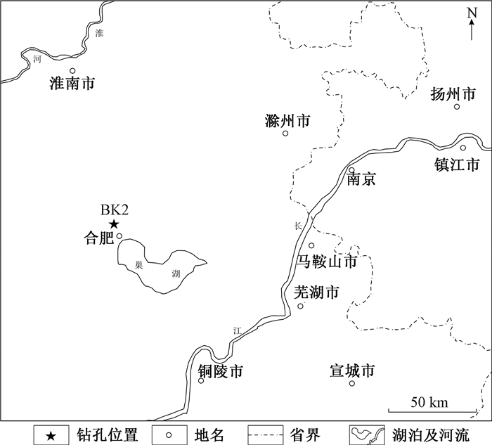
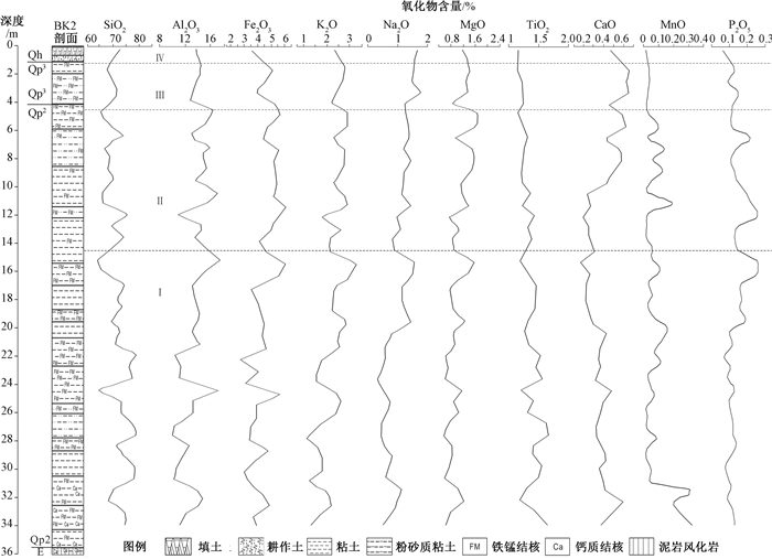
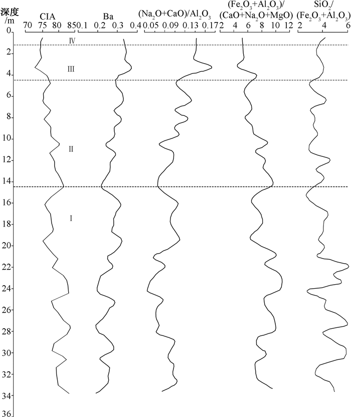
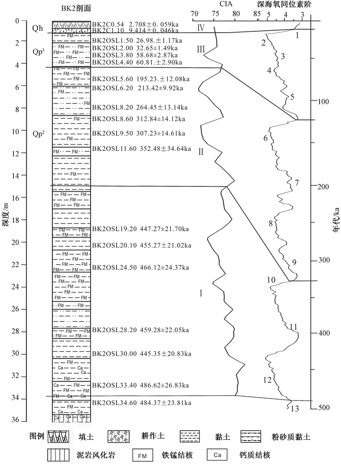
Hefei is located in the north bank of the middle and lower reaches of the Yangtze river and Xiashu loess is widely distributed. Through the analysis of lithology, oxide content and geochemical weathering parameters of BK2 borehole section in Hefei area, the geochemical characteristics and climate change rules of the eolian sediments in Hefei area are studied. The core section of the field borehole shows good continuity of the strata, and the quaternary sedimentary framework of the hole is divided according to the age data. The bottom boundary of Qh is 1.20 m, the bottom boundary of Qp3 is 5 m, and the depths range from 5 m to 35.10 m belong to middle and late Qp2. The values of SiO2 and TiO2 in Hefei loess gradually decrease with depth, whereas those of K2O, Na2O, CaO, MgO gradually increase and those of Al2O3, Fe2O3, P2O5, MnO show no obvious increase. The average content of the main chemical constituents (SiO2+Al2O3+Fe2O3) of Xiashu loess in Hefei is up to 88.99%, which indicates that the climate in this area is relatively humid. The degree of chemical weathering is relatively strong. Weathering index and residual coefficiency decline gradually from bottom to up while Bavalue and de-alkali increase from bottom to up, which demonstrate the weathering intensity decreases from bottom to up. These imply that the wetness degree decreased gradually during the sedimentation of Xiashu Formation; The average CIA value of Xiashu loess and the degree of removing Ca, Na and K of Xiashu loess are all higher than that of Luochuan loess, indicating that the paleoclimate of Xiashu loess was warmer and wetter than that of Luochuan at accumulational stage, drier and cooler than that of Xuancheng, and closer to that of Nanjing and Zhenjiang. Geochemical feature of sedimentary records from borehole section in Hefei shows that since 0.5Ma, it has experienced the change from wet heat to dry cold, which can be roughly divided into four stages:35 m to 14.50 m, 14.50 m to 4.50 m, 4.50 m to 1.20 m, and 1.20 m to 0 m. The climate has changed from warm wet-warm dry-cold dry-warm wet, indicating that the climate change in the region has a global consistency since the middle-late Pleistocene, which matches with MIS curve.
LA-ICP-MS ZIRCON U-PB DATING AND GEOCHEMICAL CHARACTERISTICS OF THE XIWANGGOU OLIVINE PYROXENOLITE IN EAST KUNLUN
KONG Huilei, LI Yazhi, LI Jinchao, JIA Qunzi, GUO Xianzheng, ZHANG Bin
2019, 25(3): 440-452. doi: 10.12090/j.issn.1006-6616.2019.25.03.041
Abstract (285) HTML (95) PDF (25553KB)(13)
Abstract:
The mafic-ultramafic rocks in Paleo-Tethys domain of East Kunlun are not well documented. Researches on petrography, geochronology and geochemistry of the olivine pyroxenolite in Xiwanggou mafic-ultramafic intrusion, located in the Eastern Section of East Kunlun in Qinghai Province, can provide new constraints for the Late Paleozoic-Early Mesozoic tectono-magmatic evolution in East Kunlun. LA-ICP-MS zircon U-Pb dating indicates that the weighted mean age of Xiwanggou olivine pyroxenolite is (262.4±1.6) Ma, in the Middle Permian. Lithogeochemical studies show that the olivine pyroxenolite, which is calc-alkaline series, is characterized by high content of Mg#(85.31~86.27), low content of TiO2(0.41%~0.52%) and low Al2O3(3.04%~4.57%). The m/f ratios range from 5.50 to 6.18, indicative of iron series of ultrabasic rocks. This suite of rocks are enriched in LILE (such as Rb, Th, U) and Pb, relatively depleting in HFSE (such as Nb, Ta, P, Ti). The rocks have low REE contents, with slightly negative Eu anomaly(∑REE=29.79×10⁻⁶~38.96×10⁻⁶, (La/Yb)N=1.71~2.51, δEu=0.73~0.86). The geochemical characteristics show that the parental magma of olivine pyroxenolite derived probably from the mantle influenced by the subducton. The parental magma is developed by the upper crustal assimilation contamination during the magma evolution. Combined with regional evolutionary characteristics in East Kunlun, the authors consider that the Xiwanggou olivine pyroxenolite ought to be the magmatism records in the subduction of Anyemaqen-Paleo-Tethys ocean.