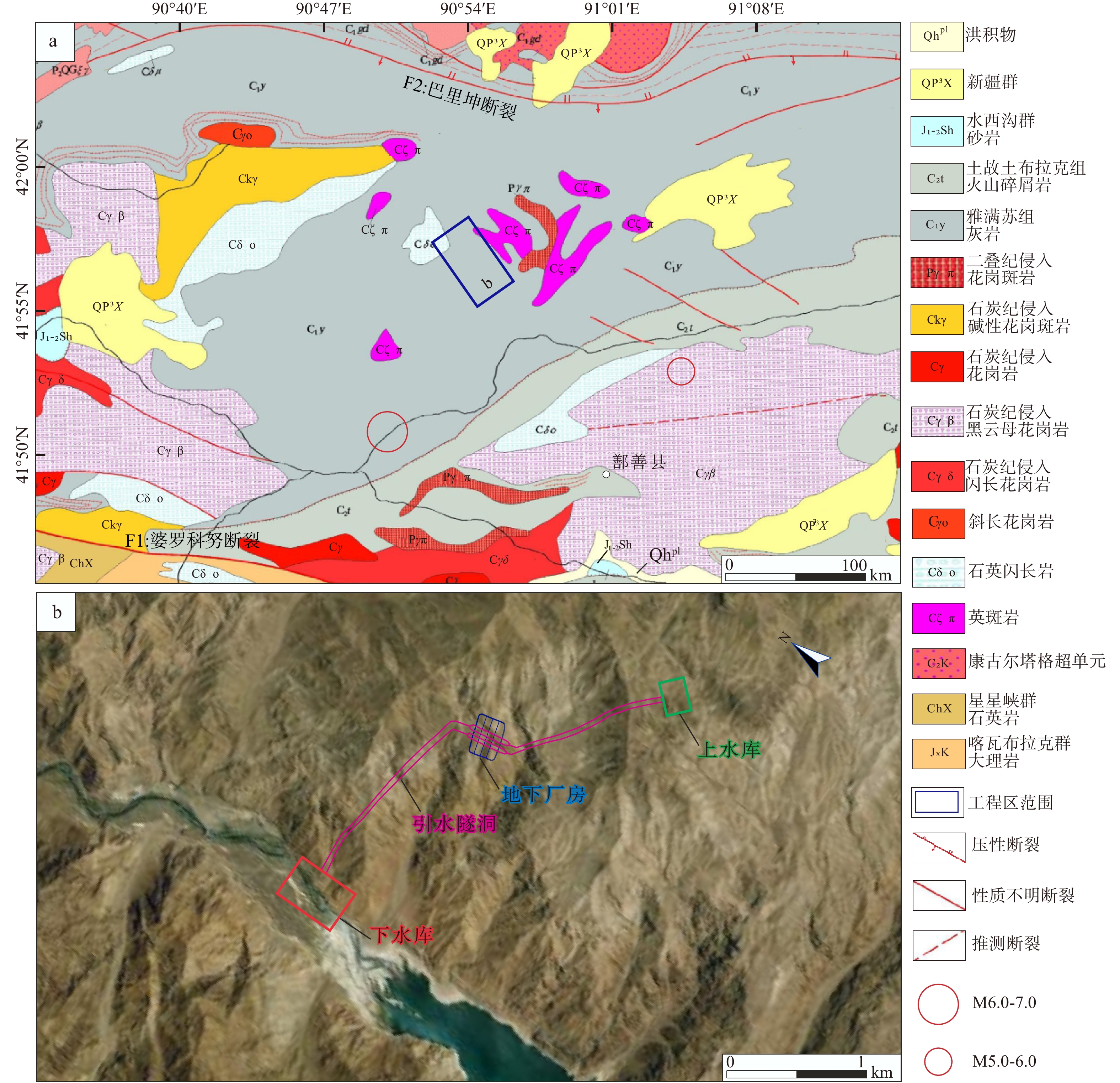
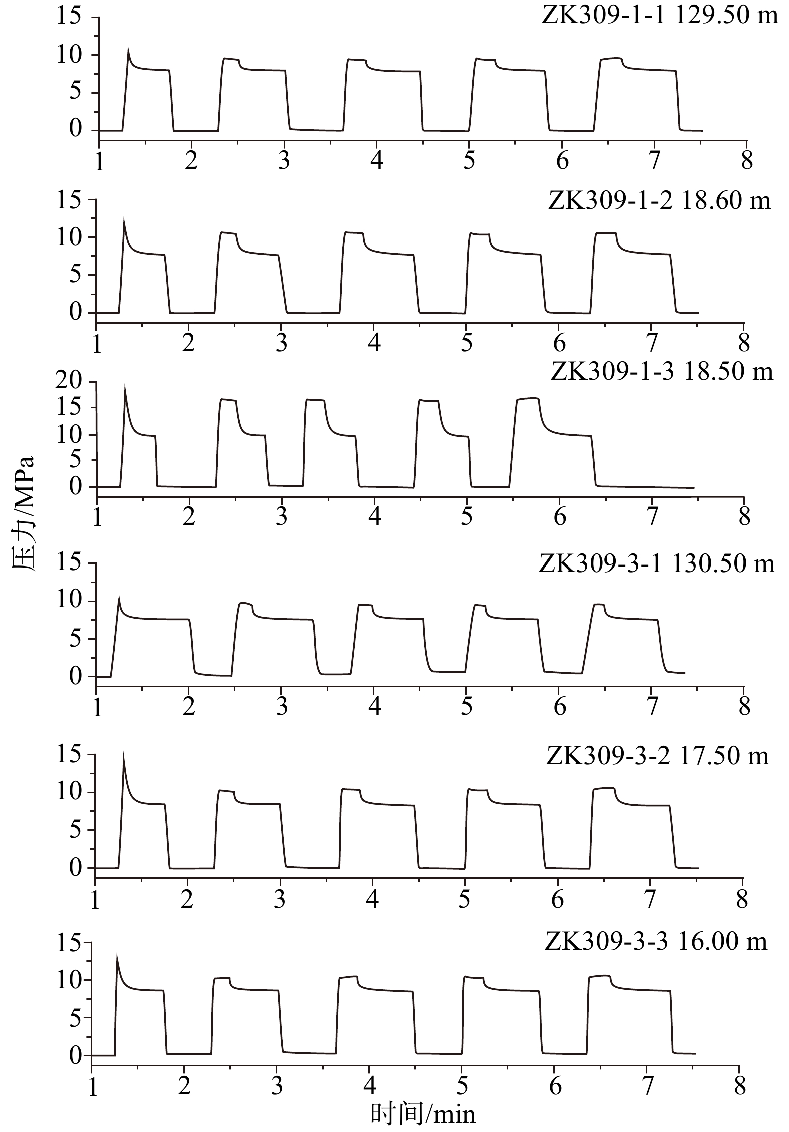
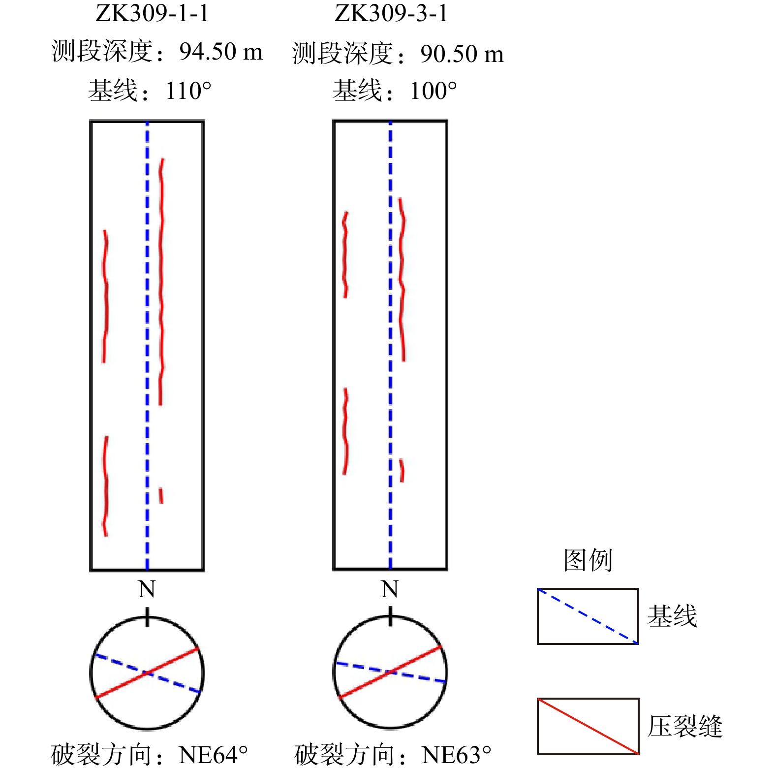
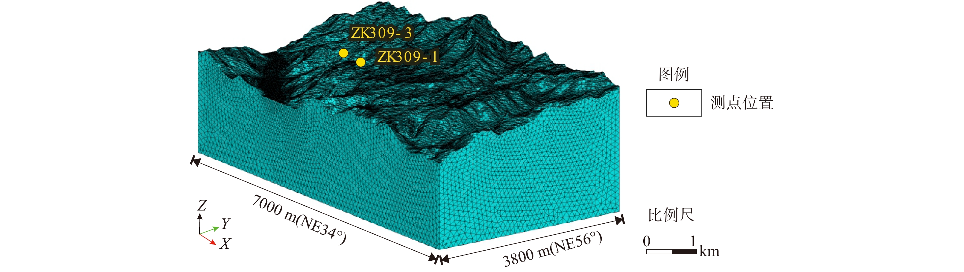
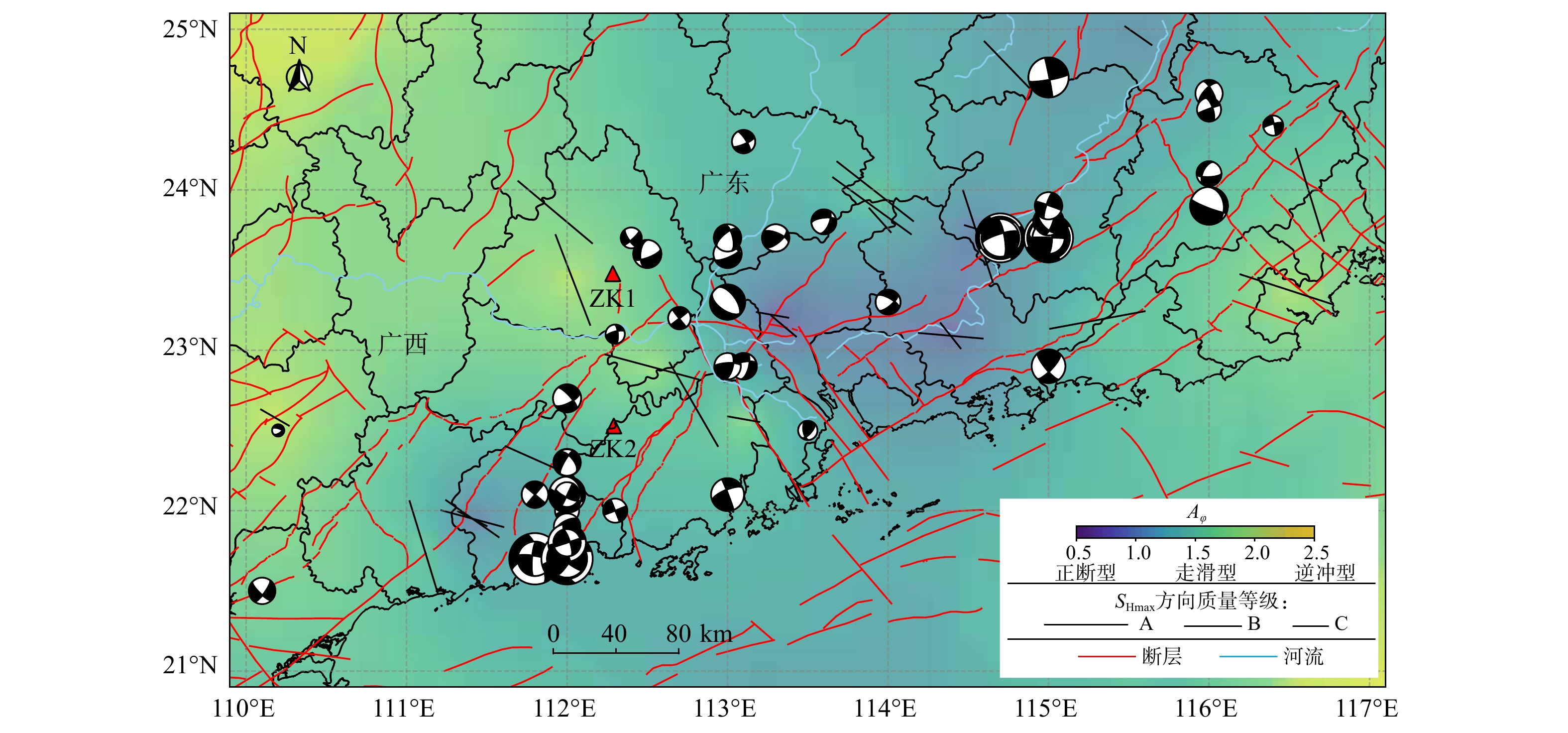
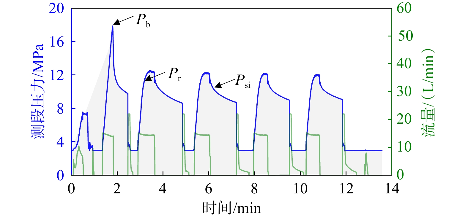
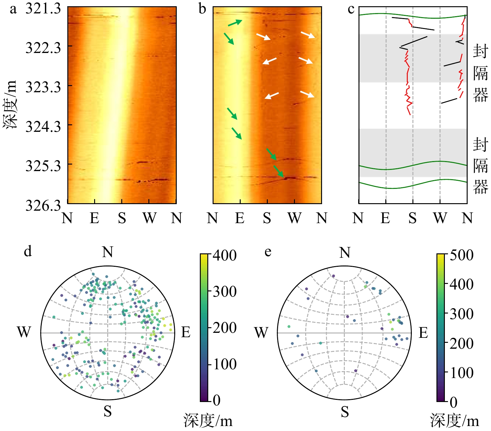
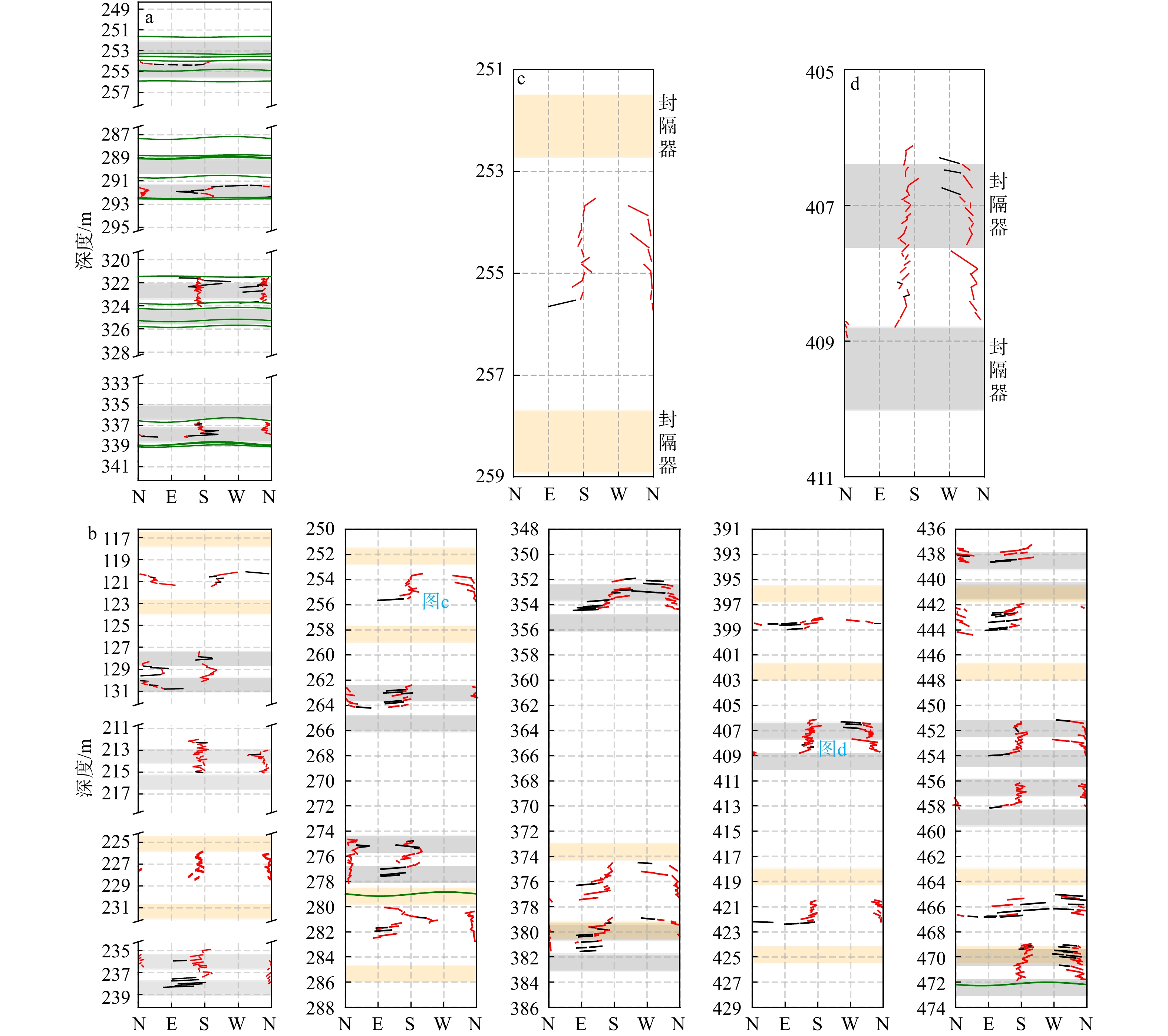
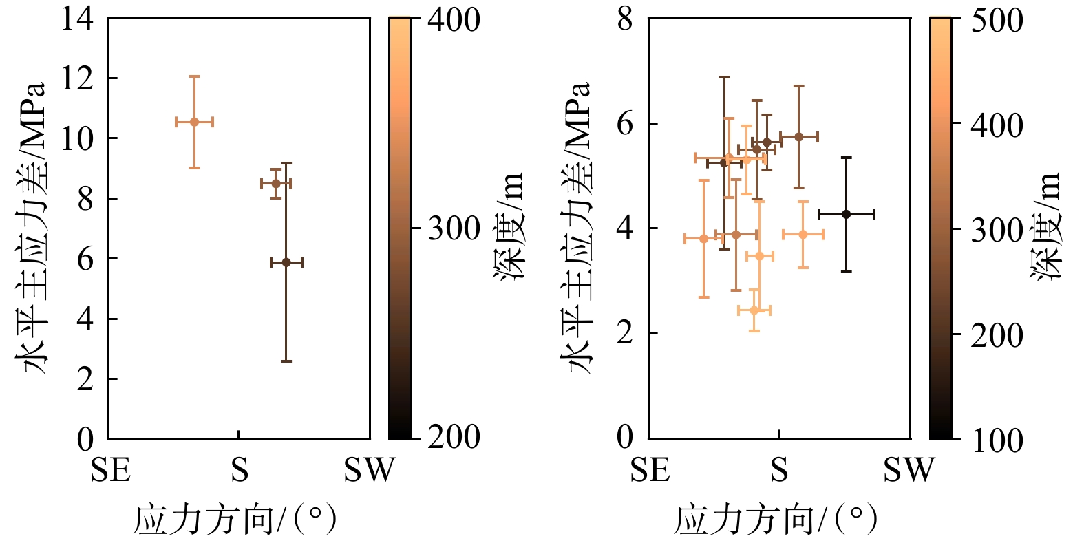
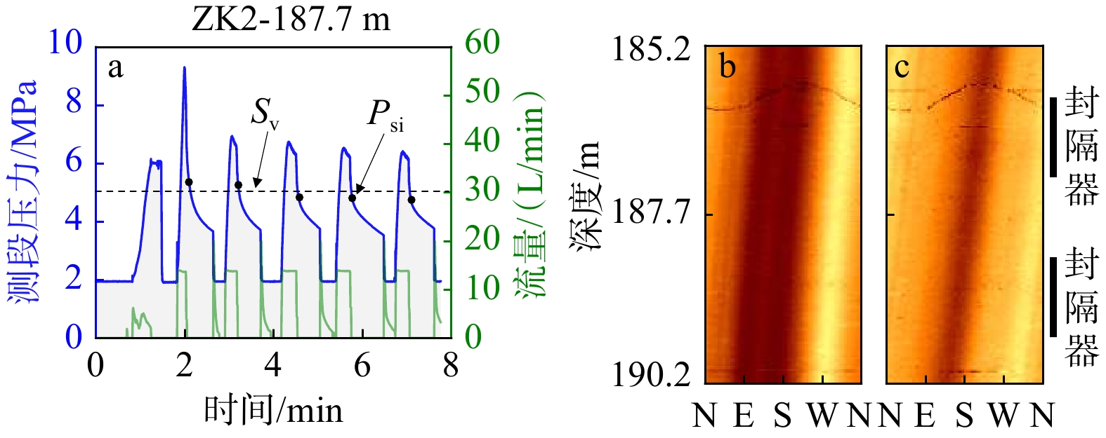
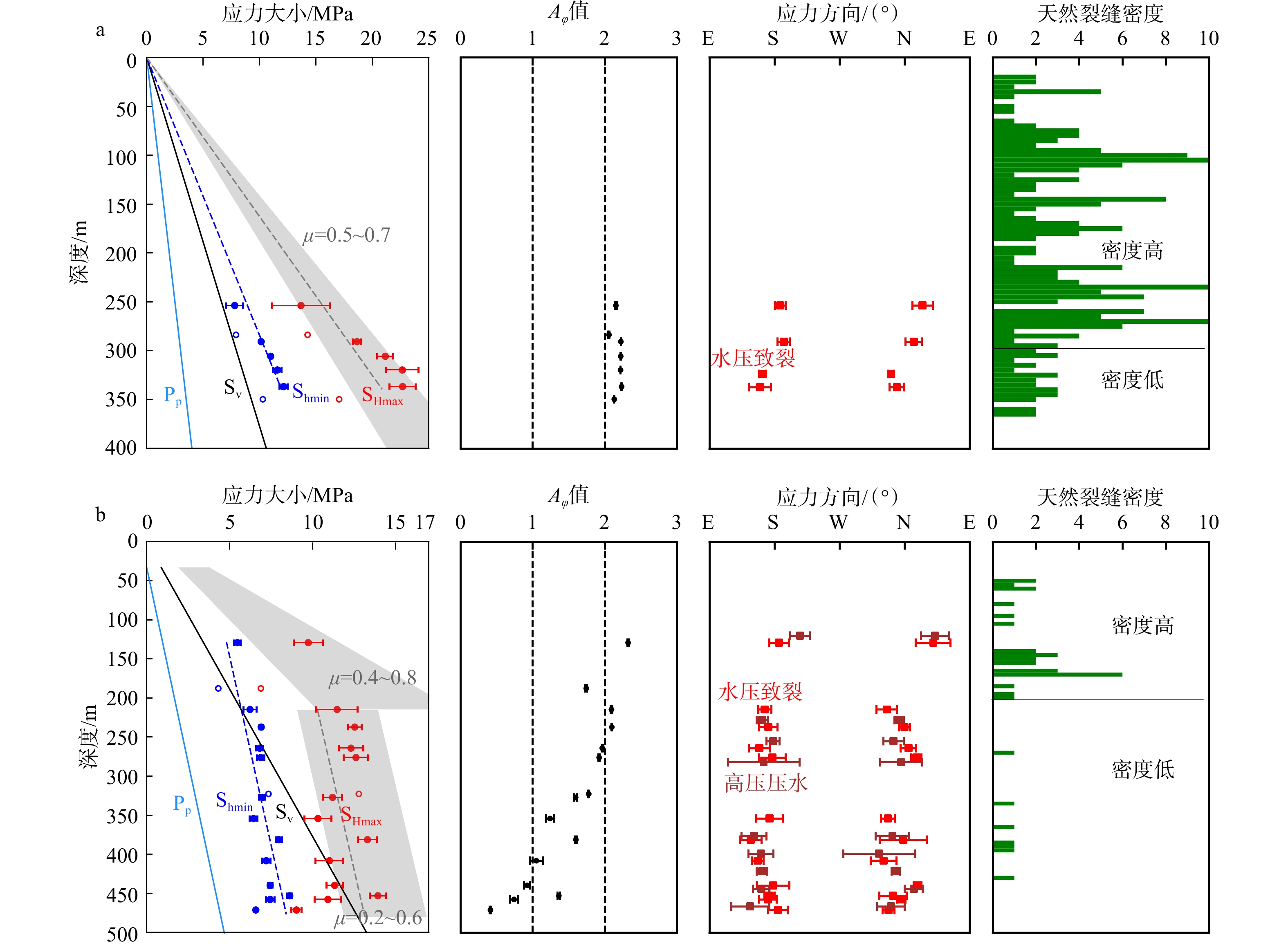
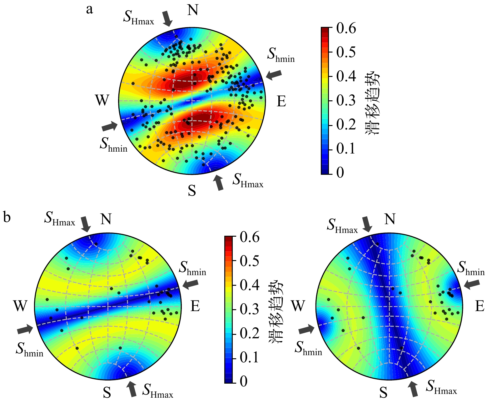
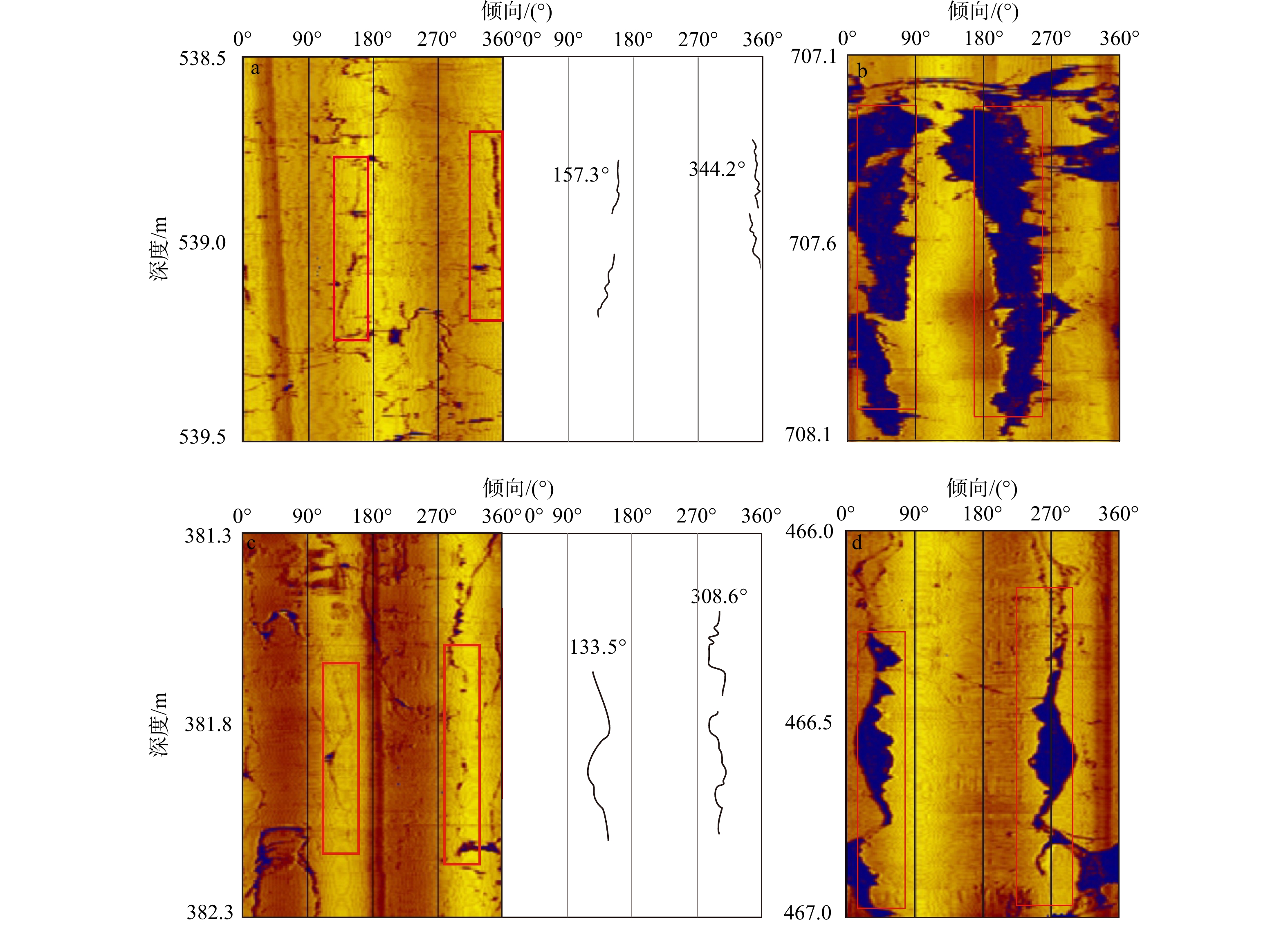
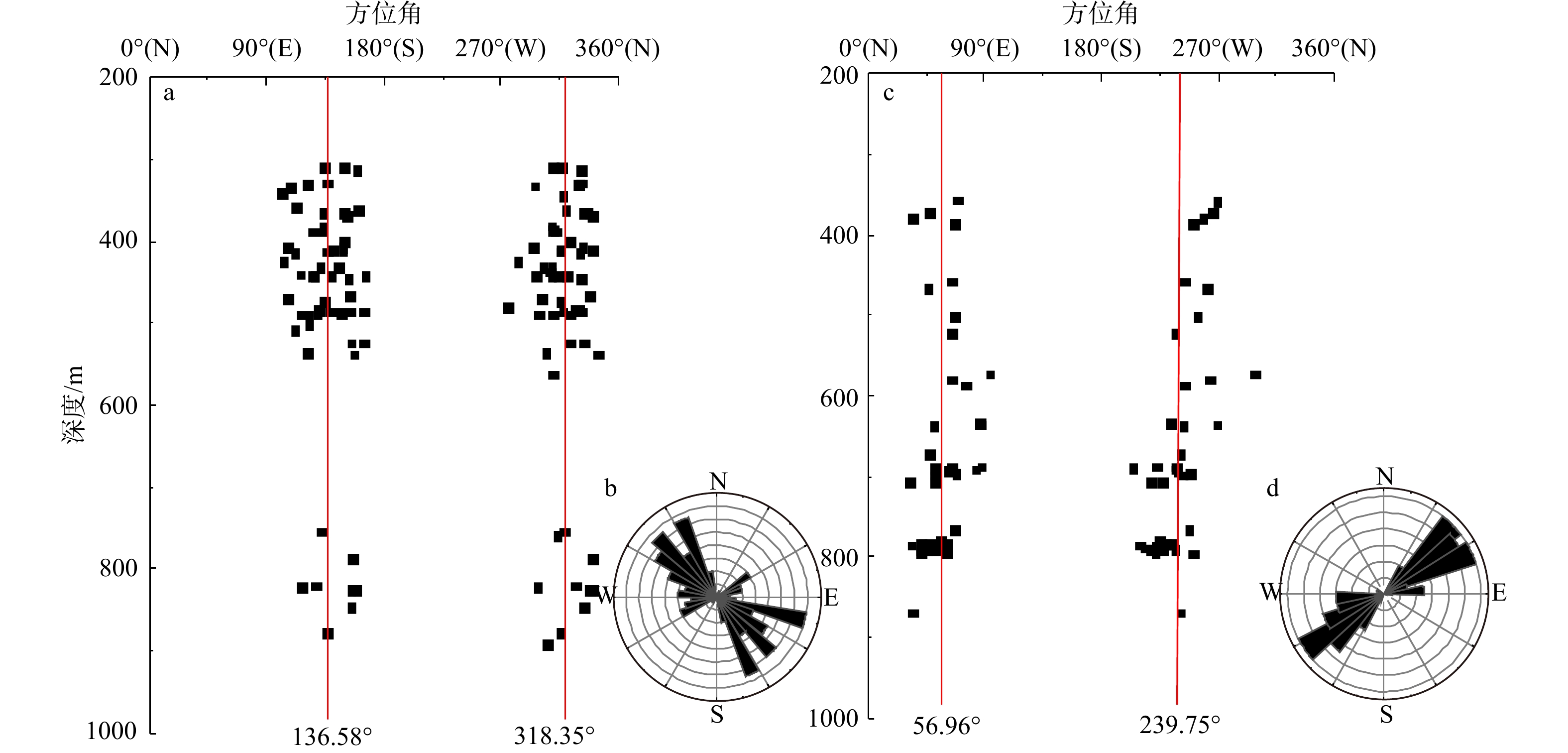
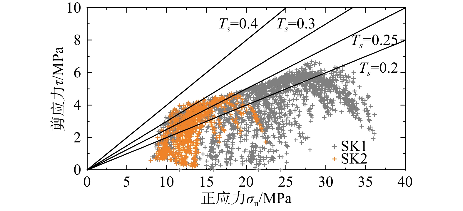
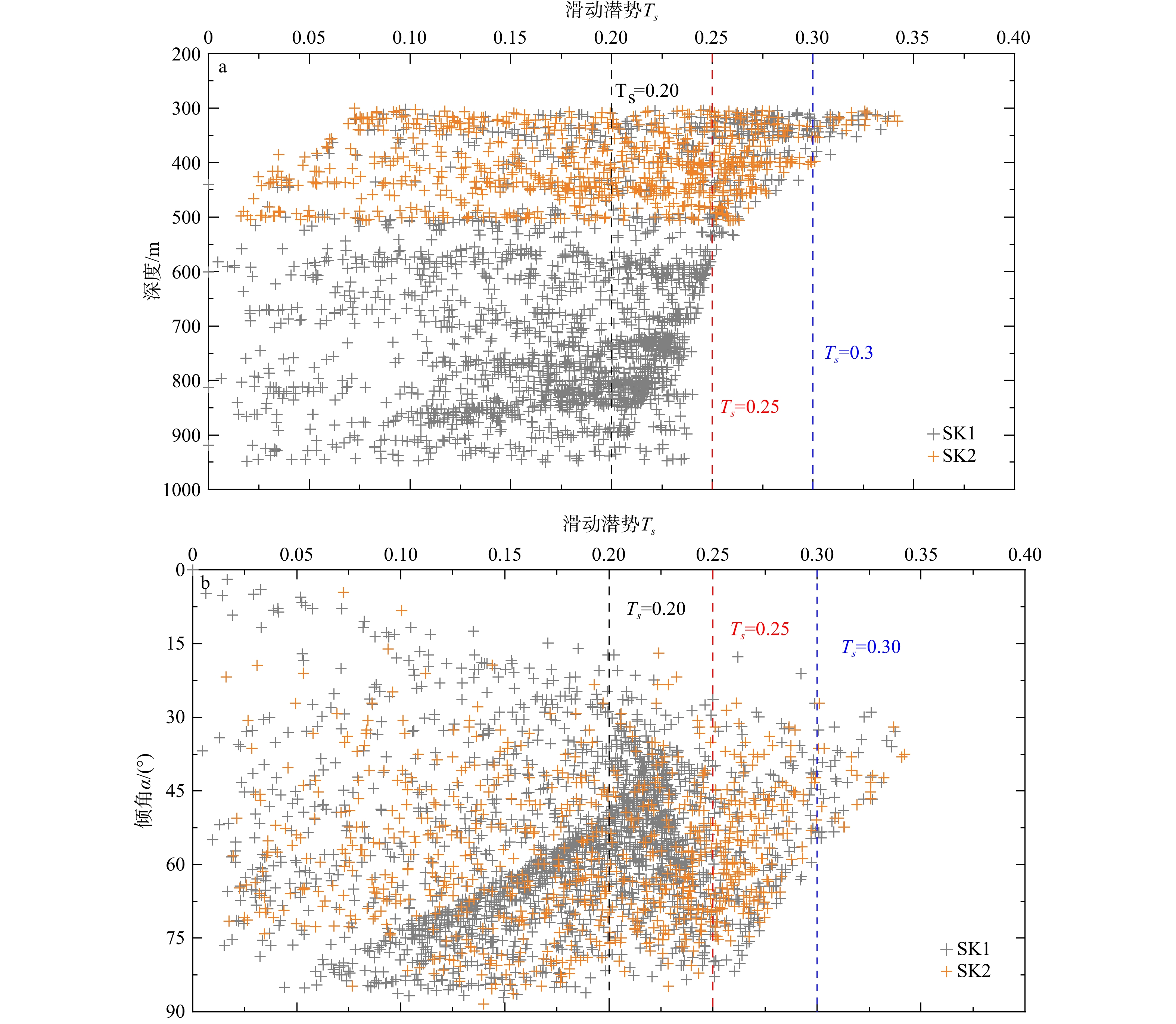
Display Method:
The stress changes of the 2025 Dingri M 6.8 earthquake on the surrounding areas
ZHANG Chenchen, WAN Yongge, GUAN Zhaoxuan, ZHAO Jiebin, WANG Runyan, ZHOU Mingyue
2026, 32(2): 1-14. doi: 10.12090/j.issn.1006-6616.2025072
Abstract (130) HTML (33) PDF (4603KB)(141)
Abstract:
  Objective  The Dingri area in Xizang is located within the Lhasa Block of the Qinghai–Xizang Plateau. It belongs to the core region of the Southern Tibetan Rift System and is a key zone with high seismic activity and earthquake potential. The M 6.8 earthquake that struck Dingri, Xizang (28.50°N, 87.45°E) on January 7, 2025, was the largest ever recorded in this area. Although previous studies have clarified the seismogenic structure and rupture distribution of this earthquake, few studies have addressed its impact on the surrounding areas. Therefore, this study calculates the co-seismic displacement and horizontal strain fields generated by the earthquake and the changes in Coulomb failure stress induced on surrounding faults. The study identifies high-risk fault segments and provides a scientific basis for regional seismic hazard assessment, monitoring, and early warning.   Methods  The local stress field was projected onto two potential nodal planes of the earthquake determined by the central focal mechanism solution; Nodal Plane I (strike 184.37°, dip 47.67°, rake –78.10°) was found to be more prone to rupture. This plane was identified as the seismogenic fault plane when combined with the strike of the local fault. Then, based on the seismic rupture model and the homogeneous elastic half-space model, the co-seismic surface displacement field and the horizontal strain field were calculated. Furthermore, according to the data on the geometry and slip properties of faults near the epicenter, the study systematically quantified the impact of the earthquake on the Coulomb stress of major surrounding faults.   Results  In terms of horizontal displacement, the materials on the east and west sides of the epicenter moved outward, while materials in some northern areas converged toward the epicenter, with a maximum horizontal displacement of 76.65 cm. In terms of vertical displacement, subsidence occurred on the north side of the epicenter (with a maximum of 83.97 cm) and uplift occurred on the northeast side (with a maximum of 33.25 cm), showing an obvious normal fault mechanism near the seismogenic fault. Volumetric strain and areal strain exhibited consistent distribution patterns; both exhibited tension on the north and south sides of the epicenter (with maxima of 1.768×10⁻⁶ and 1.737×10⁻⁶, respectively) and compression around the epicenter as well as on the east and west sides (with maxima of 1.874×10⁻⁶ and 1.987×10⁻⁶, respectively). Coulomb failure stress induced by this earthquake on the major surrounding faults at a depth of 10 km showed that the Dengmecuo Fault experienced significant stress unloading. This was the most intense stress release among all faults, effectively releasing regional tectonic stress and confirming that the Dengmecuo Fault is the seismogenic fault. The maximum Coulomb stress increment of the southern segment of the Shenza–Dingjie Fault was 0.0349 MPa, and that of the eastern segment of the Lazi–Qiongdoujiang Fault was 0.0191 MPa. Both exceeded the triggering threshold of 0.01 MPa, indicating high seismic hazard.  Conclusion  The study shows that this earthquake was a normal-faulting earthquake under the regional tectonic stress field and the Dengmecuo Fault was the seismogenic structure. Significant changes occurred in the co-seismic displacement field and the horizontal strain field around the epicenter. The Coulomb stress increments of the southern segment of the Shenza–Dingjie Fault and the eastern segment of the Lazi–Qiongdoujiang Fault exceeded the triggering threshold, indicating that moderate to strong earthquakes are possible in these segments in the future, which requires high attention. [Significance] By analyzing the impact of the January 7, 2025, M 6.8 Dingri earthquake in Xizang on the Coulomb stress of major faults in southern Xizang, this study identified the high-risk fault segments that need focused attention, providing a valuable reference for subsequent seismic monitoring and early warning.
Composition, tectonic framework, and evolution of the Luxi Orogenic Belt in the North China Craton during the Late Neoarchean
WANG Dongming, HU Jianmin, ZHAO Yuanfang, YAN Jiyuan, GONG Wangbin, ZHANG Zhigang
2026, 32(2): 1-27. doi: 10.12090/j.issn.1006-6616.2025033
Abstract (344) HTML (67) PDF (8668KB)(164)
Abstract:
  Objective  The growth and evolution of the early Earth’s crust are hot topics in Precambrian research. As one of the oldest cratons in the world, the North China Craton (NCC) has undergone a complex cratonization process accompanied by crustal growth and reworking.   Methods  Existing petrological, geochemical, chronological, and structural geological studies are summarized to reveal the tectonic evolution of the Luxi granite–greenstone belt in the eastern NCC.   Results  Multiple lines of evidence indicate late Neoarchean crustal growth, including continental arc and arc magmatic rocks represented by the Feicheng‒Tengzhou magmatic arc and late Neoarchean volcanic rocks, post-collisional crustal-derived magmatism represented by the Lushan‒Yishui magmatic belt, sedimentation in a back-arc basin defined by late Neoarchean metamorphic sedimentary rocks, and the strike-slip shear deformation caused by the oblique convergence of plates. The >2.60 Ga tonalite, trondhjemite, granodiorite (TTG) suite and the supracrustal rock belt exposed in the central part of the Luxi area represent an ancient microcontinent with apparent affinity to the Jiaoliao Block.  Conclusions  Therefore, the Luxi granite–greenstone belt is an accretionary orogenic belt located on the western margin of the Jiaoliao Block, namely the Luxi Orogenic Belt. High-angle oblique arc-continent collision and underplating of large volumes of mantle-derived magma represent two crustal growth modes in horizontal and vertical directions, respectively. This orogenic belt has undergone multi-stage evolution, including the formation of initial oceanic crust, subduction, and intracontinental extension from the Neoarchean to the end of the Paleoproterozoic. [Significance] In the late Neoarchean, extensive crustal growth occurred around the Jiaoliao Block in the eastern NCC, which was controlled by an early plate tectonic regime characterized by hot subduction.
Refined Characterization and Analysis of Shallow Crustal Stresses Based on Hydraulic Fracturing Data
XIONG Sijie, MA Xiaodong, YANG Yuehui, WU Bangchen, LI Awei, SUN Dongsheng
2026, 32(2): 1-13. doi: 10.12090/j.issn.1006-6616.2025096
Abstract (30) HTML (8) PDF (4228KB)(33)
Abstract:
  Objective  In situ stress field characterization is crucial for underground engineering safety, rock stability evaluation, and resource development. Current research in Guangdong Province is mainly concentrated on deep crustal levels, where stress interpretations predominantly rely on focal mechanism inversion and numerical modelling, while shallow stress conditions (<500 m) remain insufficiently constrained due to a lack of direct measurements and fine-scale analysis. To address this gap, this study constructs a shallow stress profile for two boreholes (ZK1 and ZK2, both < 500 m deep) in central-southern Guangdong using hydraulic fracturing and ultrasonic imaging data, aiming to refine shallow stress magnitudes, orientations, and occurrence mechanism.   Methods  Borehole imaging was applied to record hydraulic fracture morphology before and after pressurization, ensuring accurate extraction of the principal stress orientation, while pressure curves and overburden stress were combined to determine stress magnitude. Stress regimes were further characterized using the Aφ parameter, and only intervals demonstrating reliable fracture propagation and stable pressurization response were selected to ensure high-quality stress results. Based on this, a shallow stress profile was established, and the Coulomb failure criterion was used to compute slip tendency (Ts) to evaluate natural fracture stability.   Results  Within 253.8-349.8 m in ZK1, Shmin ranges from 7.8-12.1 MPa and SHmax from 13.7-21.7 MPa, corresponding to Aφ ≈ 2-3, indicative of thrust-faulting stress. In ZK2 at 129.2-471.2 m, Shmin is 5.8-9.9 MPa and SHmax 9.7-18.2 MPa, and Aφ shows a depth-dependent transition: thrust-faulting characteristics (Aφ ≈ 2-3) above 215.3 m, strike-slip stress (Aφ ≈ 1-2) at intermediate depths, and gradual evolution toward normal-faulting stress (Aφ ≈ 0-1) at greater depths. Hydraulic fractures in both boreholes are predominantly sub-vertical with stable maximum horizontal stress orientations of N18°W in ZK1 and N15°W in ZK2, maintaining standard deviations <10°. Nonetheless, shallow intervals show pronounced azimuth deflection, with ZK1 above ~293 m deviating 23° and ZK2 above ~203 m deviating 29° toward the NNE, maybe suggesting fracture-induced heterogeneity weakens the rock mass, modifies local stress anisotropy, and causes reorientation of SHmax. Slip tendency calculations show Ts <0.4 throughout ZK2, indicating good fracture stability, whereas in ZK1, clusters within 290 ± 30 m reach Ts ≈0.6 near the frictional instability limit, accompanied by elevated SHmax relative to predicted trends, implying higher reactivation potential and mechanical risk.   Conclusions  ZK1 is dominated by thrust-faulting stress with SHmax trending ~N18°W. ZK2 exhibits a progressive transformation from thrust to strike-slip to normal-faulting stress state as depth increases, with SHmax consistently oriented between N15°W–N18°W. The shallow stress field (<500 m) is different from deeper crust (>5 km), where strike-slip and normal-fault regimes dominate due to high vertical lithostatic loads, while reduced vertical stress in shallow rock favors horizontal compression and thrust-related stress. Fractures in ZK2 are stable, whereas ZK1 contains intervals with high slip potential, which require priority monitoring. [ Significance] This work provides shallow in situ stress datasets for Guangdong derived from field measurements, significantly improves hydraulic fracturing interpretation reliability, offers essential mechanical parameters for near-surface engineering construction and hazard assessment, and demonstrates that shallow crust stress evolution is controlled by mechanisms distinct from deeper tectonic stress fields, highlighting the scientific necessity of shallow stress measurement.
Tectonic evolution of the Sumatran Fault: synthesis and perspective
GUO Lin, CHU Yang, LIN Wei, LEI Yiyang, LIU Tanjie, GUO Yilin, MENG Lingtong
2026, 32(2): 1-22. doi: 10.12090/j.issn.1006-6616.2025067
Abstract (410) HTML (98) PDF (5012KB)(165)
Abstract:
  Objective  Oblique convergence between the Indo-Australian Plate and the Eurasian Plate produced a ~1,900-km-long dextral strike-slip fault—the Sumatran Fault—within the overriding plate. While previous studies have extensively examined its geometry, kinematics, and seismicity, the tectonic evolution of the fault remains poorly constrained.   Methods  This study integrates multidisciplinary evidence from structural geology, geomorphology, seismicity analysis, geodesy (GPS), low-temperature thermochronology (apatite and zircon (U-Th)/He dating), and volcanic distribution mapping. We systematically synthesize data on fault segmentation, slip rates, cumulative displacement, magmatic-tectonic relationships, and regional geodynamic models to evaluate the fault’s spatiotemporal evolution.  Results  The Sumatran Fault is a highly segmented dextral strike-slip system that can currently be divided into 19 segments based on geometric complexity and seismic activity. Slip rates along the fault are relatively uniform from south to north, with an average around 15 mm/yr, and a total cumulative displacement of approximately 20–25 km. Regionally, the distribution of active arc magmatism closely aligns with the trace of the fault, indicating a dynamic interaction between faulting and magmatism: while magma-induced crustal weakening facilitates fault development, extensional zones associated with normal faulting in turn influence the volcanic activity. Despite its tectonic significance, low-temperature thermochronological studies on the Sumatran Fault remain limited. Existing thermochronological data reveal a period of rapid uplift at ~2 Ma, likely driven by dip-slip motion along the fault.   Conclusion  A three-stage model is proposed. Before 2 Ma, oblique convergence was primarily accommodated by forearc faults (e.g., Mentawai Fault) and shear zones. Around 2 Ma, the Sumatran Fault initiated contemporaneously with the Mentawai Fault, manifesting strain localization in the overriding plate. At present, the Sumatran Fault accommodates the majority of the strain, while strike-slip motion on the Mentawai Fault has significantly diminished. The uplift phase correlates with the initial timing of the Sumatran Fault inferred from present-day slip rates and cumulative offsets, suggesting that the current through-going structure of the fault and the modern tectonic framework were established at the same time. [ Significance ] This study provides a comprehensive synthesis of multidisciplinary constraints on the Sumatran Fault and establishes a unified spatiotemporal framework for its tectonic evolution. By integrating fault segmentation, slip rates, thermochronological data, and magmatic–tectonic interactions, this study clarifies the timing of fault initiation and the development of the present-day tectonic architecture. The results offer new insights into strain partitioning and the formation of trench-parallel strike-slip faults at obliquely convergent margins, providing a valuable reference for understanding similar plate boundary systems and their associated seismic hazards.
Geochemical characteristics of Late Paleozoic–Early Mesozoic volcanic rocks in Heiyingshan, Beishan Orogenic Belt: evidence of the transition from subduction to collision of the Paleo-Asian Ocean
DING Yiwen, SHAO Zhaogang, CHEN Yanfei, CHEN Xuanhua, LI Bing, YU Wei, XU Daxing, HAN Lele
2026, 32(2): 1-16. doi: 10.12090/j.issn.1006-6616.2025017
Abstract (393) HTML (70) PDF (3655KB)(147)
Abstract:
  Objective  It is generally accepted that the Paleo-Asian Ocean in the northern part of the Beishan Orogenic Belt was in the stage of ocean–continent evolution during the Carboniferous–Permian. However, the timing of the closure of the Paleo-Asian Ocean remains controversial. The Heiyingshan area, located at the northern margin of the Beishan Orogenic Belt, is a key area for studying the evolution of the Paleo-Asian Ocean. This study analyzes the geochemical characteristics of tuffs in this area to reveal their tectonic setting and further constrain the evolution of the Paleo-Asian Ocean in the northern Beishan Orogenic Belt.  Methods  Late Carboniferous and Late Triassic volcanic tuffs exposed in the Heiyingshan area were analyzed using petrological and geochemical methods. Major, trace, and rare earth elements concentrations were determined to obtain the geochemical characteristics of the volcanic tuffs. Combined with published regional volcanic rock ages and geochemical data, the petrogenesis and tectonic setting of the volcanic tuff are discussed.   Results  The Late Carboniferous volcanic tuff belongs to the peraluminous calc-alkaline series; it is enriched in large ion lithophile elements (LILE; i.e., Rb, Ba, Th and U) and depleted in high field strength elements (HFSE; i.e., Nb, Ta, Zr, Hf and Ti). The total rare earth element content (ΣREE) ranges from 74.64×10⁻⁶ to 142.45×10⁻⁶, with significant fractionation between light and heavy REEs (LREE/HREE=5.14–7.49, (La/Yb)N=4.58–6.36). The chondrite-normalized REE distribution pattern is right-leaning, with a weak negative Eu anomaly (δEu=0.35–0.66). These characteristics are indicative of I-type granite. The Late Triassic volcanic tuff belongs to the peraluminous high-K calc-alkaline series. It is enriched in silicon and alkali but depleted in aluminum and magnesium. This tuff exhibits a strong negative Eu anomaly (δEu=0.02–0.22). Its chondrite-normalized REE distribution pattern is a slightly right-leaning ‘seagull type’. This tuff is enriched in LILE, (e.g., Rb, Th and U), depleted in incompatible elements (e.g., Ba, Nb, Zr and Ti), and depleted in HFSE, (e.g., Hf and Zr). These characteristics are typical of S-type granite. The Th content of the Late Carboniferous and Late Triassic rock samples in the Heiyingshan area ranges from 7.66 to 32.2μg/g, with an average of 19.24μg/g, which is much higher than the average mantle abundance and closer to the crust. The Nb/Ta ratios of the rock samples range from 8.01 to 12.78, with an average of 10.36, which is much lower than the mantle average of 60 and closer to the crust average of 11. In addition, the Ba/La ratios of the Late Carboniferous volcanic rocks range from 19.19 to 24.09, with an average of 21.64, slightly higher than the continental crust average of 15.63.   Conclusion  The Late Carboniferous and Late Triassic volcanic tuffs in the Heiyingshan area formed in the subduction and collision setting of the Paleo-Asian Ocean, respectively, indicating that the tectonic environment in the Hongshishan-Heiyingshan area transitioned from subduction to collision between the Late Carboniferous and the Late Triassic. The volcanic magma in this area was mainly derived from partial melting of the crust, with the Late Carboniferous volcanic rocks possibly mixed with a small amount of mantle-derived materials. [ Significance ] The geochemical characteristics of the Late Carboniferous and Late Triassic volcanic tuffs in the Heiyingshan area provide evidence for the subduction–collision processes of the Paleo-Asian Ocean in the Beishan Orogenic Belt. The results constrain the timing of the tectonic environment transformation in the Hongshishan–Heiyingshan area in the northern Beishan Orogenic Belt, which is of great significance for understanding the closure of the Paleo-Asian Ocean.
Study of disaster-prone geological structures and instability modes of typical goaf landslides in mountainous areas of southwest China
ZHANG Haoxiang, ZHU Sainan, YAO Leihua, GAO Feng, ZHANG Limei, YANG Long, TAN Weijia, DAI Xusheng, GAO Yu
2026, 32(2): 1-16. doi: 10.12090/j.issn.1006-6616.2025047
Abstract (232) HTML (45) PDF (2507KB)(147)
Abstract:
  Objective  Landslides occur frequently in the goaf areas of mountainous areas in Southwest China. This study aims to explore the commonalities and differences among such landslides to support the development of scientific disaster prevention and mitigation measures.   Methods  A comparative study was conducted using three research objects: the Jiguanling Landslide in a limestone area, the Zhaojiagou Landslide in a clastic rock area, and the Shanyang Landslide in a metamorphic rock area. Methods included data collection and analysis, on-site investigation, multi-phase remote sensing interpretation, physical and mechanical testing of rock and soil masses, and numerical simulation. These methods were employed to analyze similarities and differences in disaster-prone geological structures and instability mechanisms among the selected landslides.  Results  Landslide disasters are prone to occur on slopes characterized by steep terrains, favorable overhanging conditions, and binary structures. Numerical simulations indicate that under goaf conditions, the displacement of each landslide increases, the maximum shear strain increments concentrate on the potential sliding surface and the goaf roof area, and the overall stability of each landslide decreases.   Conclusions  The limestone mountainous area is characterized by thick layers of hard rock interbedded with thin layers of soft rock, presenting high rock mass strength. The Jiguanling Landslide belongs to the toppling–sliding failure mode. The clastic rock mountainous area is affected by interbedding of thin layers of fragmented soft and hard rock, with overall rock mass strength weakened. The Zhaojiagou Landslide belongs to the creep–tensile fracture failure mode. The metamorphic rock mountainous area exhibits hard rock at the top and soft rock at the bottom, with significant differences in strength. The Shanyang Landslide belongs to the slipping-collapse failure mode. [ Significance ] This study provides an important scientific basis for the early identification of goaf landslides and for studying goaf-related disaster formation patterns.
The evolution of the Sinian–Early Cambrian E’xi Trough in the Central Yangtze region and its geological significance for natural gas
CHEN Ke, LU Yanxin, WANG Yuluo, LI Fei
2026, 32(2): 1-17. doi: 10.12090/j.issn.1006-6616.2025048
Abstract (23) HTML (5) PDF (4934KB)(16)
Abstract:
  Objective  From the Neoproterozoic Sinian to the Early Cambrian periods, extensive basins in South China accumulated substantial volumes of organic-rich shale and carbonate rocks, providing high-quality source rocks and reservoirs. These basins constitute key targets for petroleum exploration. The Central Yangtze Region hosts the Sinian–Early Cambrian E’Xi trough, whose formation and evolutionary processes require further investigation.   Methods  Comprehensive analyses integrating drilling data, outcrop sections, and seismic profiles reveal the evolution history of this north-south-trending trough.   Results  Research indicates four distinct developmental stages: (1) During the deposition of the Nantuo Formation, an initial subsidence center emerged in western Hubei with limited tillite thickness; (2) The Doushantuo Formation developed in a half-graben basin system, coinciding with the post-Snowball Earth warming and humidification, which fostered syn-depositional faulting along the eastern trough margin; (3) The deposition of the Dengying Formation was characterized by carbonate platform with the establishment of a "two-platform, one-basin" architecture across the Central–Upper Yangtze region and the development of a complete graben basin in western Hubei; (4) The Niutitang Formation, dominated by clastic sediments, exhibits thickness complementarity with the underlying Dengying dolomites, marking trough filling and termination.   Conclusions  Members II and IV of Doushantuo Formation, together with Member II of the Niutitang Formation, host organic-rich shales, which constitute the primary targets for shale gas exploration. Conventional hydrocarbon systems display a "sandwich-style" accumulation model comprising Doushantuo source rocks, Dengying reservoirs, and Niutitang seal/source couples. Multiphase tectonic activities have disrupted some oil and gas closed systems, while excessive burial depths locally induced overmatured organic matter. Therefore, the key to shale gas exploration is identifying tectonically stable areas with moderate maturity levels, while the strategic focus for conventional natural gas exploration is prioritizing regions characterized by effective hydrocarbon accumulation and favorable preservation conditions.
Characteristics of current in-situ stress field and engineering zoning evaluation of complex structural areas: A case study of the Longmaxi shale reservoir in the southeastern Sichuan Basin margin
MA Shunting, LI Ruixue, CHEN Xinhao, DU Yifei, DENG Hucheng, HE Jianhua, YANG Hong, WEI Limin
2026, 32(2): 1-18. doi: 10.12090/j.issn.1006-6616.2025057
Abstract (40) HTML (8) PDF (6093KB)(3)
Abstract:
  Objective  The Dingshan–Dongxi area on the basin margin in southeastern Sichuan is located at the junction of the eastern Sichuan faul–fold zone and the northern Guizhou fault–fold zone on the east side of the Luzhou–Chishui tectonic superposition zone. Affected by multiple tectonic movements, the structure is complex. The Longmaxi Formation in the study area is rich in shale gas resources, with superior geological and reservoir formation conditions, and has great potential for exploration and development. Clarifying the current in-situ stress state and its distribution law is conducive to improving the development efficiency of shale gas. However, the current in-situ stress field in this area is complex, resulting in less precise planar prediction results and significant differences in the fracturing stimulation effect and production between horizontal wells.   Method  This study provides a detailed interpretation of the direction of the in-situ stress in the well profile of the study area, integrating multi-source data including core tests, well logging and microseismic monitoring. Furthermore, the distribution characteristics of in-situ stress magnitudes of the well profile are clarified through hydraulic fracturing, acoustic emission experiments and well logging. The structural deformation and fracture characteristics of the study area were subjected to refined geological modeling and heterogeneous rock mechanics were assigned. Numerical simulation software was applied to simulate the current in-situ stress distribution characteristics of the study area. Finally, based on the analysis of the influence of current in-situ stress characteristics on the effect of fracturing modification, the in-situ stress zoning evaluation standard was constructed. Combined with the simulated results of the in-situ stress field, the in-situ stress zoning was carried out in the Dingshan–Dongxi area, and the zoning outcome was verified through the retrospective evaluation of the fracturing effect of new wells.   Results  The results show that the current in-situ stress direction in the study area is mostly near-EW direction, and local deflection occurs due to the influence of fractures and structural deformations. The maximum horizontal, minimum and vertical horizontal principal stresses range from 58.4–167.0 MPa, 38.6–135.4 MPa, and 54.7–148.2 MPa, respectively, indicating a strike-slip stress state. The differences between maximum and minimum horizontal principal stress mainly distributed between 5 and 30 MPa. The magnitude of in-situ stress and the difference between maximum and minimum horizontal principal stress are generally controlled by the burial depth. The in-situ stress and the difference between maximum and minimum horizontal principal stress both are lower in areas with high structural deformation, while the in-situ stress is lower and the difference between maximum and minimum horizontal principal stress is higher near faults. The zoning is carried out with a minimum horizontal principal stress of 80 MPa and a difference between maximum and minimum horizontal principal stress of 20 MPa. It is recommended to select the areas with low stress difference and low in-situ stress to conduct fracturing stimulation. These areas are mainly located in the high structural parts of the gentle slope area in the middle of Dingshan, the slope area of Dongxi, and the northern part of the Dongxi fault and anticline area. [ Significance ] This study advances the understanding of the current in-situ stress field of the Longmaxi Formation in the southeastern margin of the Sichuan Basin and possesses significant practical value for the optimization of fracturing stimulation.
Analysis of the three-dimensional in situ stress state and underground cavern stability of a pumped storage hydropower station in Xinjiang, China
ZHANG Xiaofei, WANG Jiming, ZHANG Peng, LI Zhengzheng, Li Changhu, OUYANG Jiangquan
2026, 32(2): 1-16. doi: 10.12090/j.issn.1006-6616.2025076
Abstract (301) HTML (61) PDF (2443KB)(155)
Abstract:
  Objective  This study investigates the in situ stress field and stability of the surrounding rock in the underground caverns of a large-scale, deeply buried pumped storage power station located on the southern margin of the Tianshan Orogenic Belt in Xinjiang. It aims to ensure the geological safety of the underground powerhouse and water diversion tunnels.   Methods  First, two sets of three-dimensional hydraulic fracturing stress measurements were carried out in the underground powerhouse to obtain fundamental data on the in situ stress field. Subsequently, a 3D geological model of the project area was established, and the 3D in situ stress field was inverted using finite element numerical simulation. Finally, the stability of the underground caverns was evaluated based on the distribution of the 3D stress field from two aspects: the rationality of the cavern axis layout and the risk of rockburst in the surrounding rock of the underground powerhouse and water diversion tunnels.   Results  (1) The 3D in situ stress measurements in the underground powerhouse revealed the following: The maximum principal stress (σ1) ranges from 16.19 to 16.23 MPa, with an azimuth of N43.98°E–N54.44°E and a dip angle of −4.81° to 6.93°; the intermediate principal stress (σ2) ranges from 9.82 to 12.23 MPa, with an approximate SE orientation and a dip angle of −18.89° to −14.52°; and the minimum principal stress (σ3) ranges from 6.90 to 10.41 MPa, with a near-vertical dip. (2) The 3D stress field inversion shows that the maximum principal stress (σ1) in the underground powerhouse ranges from 16.54 to 17.21 MPa, with an azimuth of N47.88°E–N56.32°E; Along the axis of the water diversion tunnel, σ1 ranges from 14.86 to 24.32 MPa.   Conclusion  The angles between the axes of the underground powerhouse and water diversion tunnels and the measured maximum horizontal principal stress (SH) deviate by ≤10° from the optimal angle (62.84°) for an SHV-type stress field, which is favorable for cavern stability. Based on multiple criteria, including the rock strength–stress ratio method and Tao Zhenyu’s criterion, the surrounding rock of the underground powerhouse and water diversion tunnels is generally classified as having a slight rockburst risk. [ Significance ] The findings provide a scientific basis for the design and construction of the underground powerhouse and water diversion tunnels of this pumped storage power station. They also fill a gap in 3D in situ stress measurement data for the southern margin of the Tianshan Orogenic Belt in Xinjiang.
Analysis of structural plane stability in the Panlong lead–zinc mine, Guangxi, China and its engineering implications
HUANG Xiaopan, WANG Chenghu, YANG Chengwei, LIU Jikun, XIAO Haifan
2026, 32(2): 1-13. doi: 10.12090/j.issn.1006-6616.2025083
Abstract (283) HTML (67) PDF (2443KB)(154)
Abstract:
  Objective  The Panlong lead–zinc mine, an important polymetallic mine in central Guangxi, faces increasing challenges related to high in-situ stress and structurally complex rock masses as mining progresses to greater depths. Instabilities along structural planes have become a major geotechnical hazard. However, current understanding of the interplay between fracture geometry and the stress field remains limited. This study aims to evaluate the stability of structural planes at depth and their implications for safe mine development.   Methods  High-resolution data on fracture orientation and spacing were obtained through ultrasonic borehole television imaging in boreholes SK1 and SK2. Hydraulic fracturing tests were used to determine the magnitude and orientation of in-situ stresses. Stress tensor transformation and the Coulomb friction criterion were applied to estimate shear and normal stresses on structural planes and to assess their slip tendency under current stress conditions.   Results  The rock mass in the Panlong mine contains steeply dipping structural planes predominantly oriented NW–NNW and NE–NEE. Cluster analysis revealed three dominant fracture sets, reflecting tectonic control from nearby faults. Furthermore, in-situ stress measurements between 500 and 850 m depth show SH = 28.29−44.69 MPa, Sh = 19.46−27.09 MPa, and Sv = 14.50−22.68 MPa. The lateral stress coefficients kH and kh average 2.07 and 1.28, respectively, indicating a horizontal compressive regime with SH oriented NW–NNW. Analysis of borehole breakouts and drilling-induced fractures supports the NW–NNW orientation of maximum horizontal stress. Subsequently, a total of 2,948 structural planes were analyzed. Slip tendency evaluation based on slip tendency (Ts = 0.2−0.4) shows that fractures with Ts > 0.20 are primarily distributed at depths less than 550 m. Steeper fracture planes (40°−75°) exhibit a high slip potential, indicating a higher likelihood of shear slip. NW–NNW-oriented planes exhibit both high density and high slip potential, especially when fracture aperture exceeds 10 mm.   Conclusion  The structural planes in the Panlong mine are characterized by steep dips and strong orientation clustering, primarily NW–NNW and NE–NEE, reflecting significant tectonic control. The in-situ stress regime is governed by horizontal compression, which favors the activation of reverse faults. This aligns with observed fracture development and supports the role of tectonic faults in stress field evolution. NW–NNW-oriented fractures, particularly those with low slip tendency and wide apertures, pose the highest risk for shear reactivation under current conditions and require targeted monitoring and support. Furthermore, structural planes in shallow zones (<550 m) present a higher slip potential than those in deeper zones, emphasizing the need for depth-specific design strategies. [ Significance ] These findings provide a detailed understanding of structural plane behavior under deep mining conditions and offer scientific support for roadway layout optimization, support system design, and hazard mitigation.
A calculation method of the reservoir Biot coefficient based on the Griffith criterion and the equivalent inclusion theory
ZHANG Hui, PEI Chenyang, WANG Zhimin, LIU Lei, LI Jing, LIU Yishuai, WU Zekun
2026, 32(2): 1-10. doi: 10.12090/j.issn.1006-6616.2025086
Abstract (111) HTML (18) PDF (869KB)(133)
Abstract:
  Objective  The Biot coefficient is defined as the ratio of the change in pore volume to the change in total rock volume, reflecting how efficiently pore pressure offsets externally the applied total stress under loading conditions. As a key parameter in poroelastic theory, the Biot coefficient links pore pressure to effective stress in a reservoir and plays a critical role in geostress calculation and wellbore stability analysis.   Methods  Based on the equivalent inclusion theory, this study introduces parameters such as the polarization factor and fracture aspect ratio to characterize the influence of fracture geometry on mechanical reservoir properties. Combined with the Griffith fracture criterion, a method for determining the expected aspect ratio of fractures is developed, leading to analytical expressions for the Biot coefficient in both fractured reservoirs and dissolution cavity reservoirs.   Results  Compared with field-measured geostress data, the maximum and minimum horizontal principal stresses calculated using the proposed Biot coefficient method yield maximum errors of 5.75% and 6.03%, respectively, meeting engineering accuracy requirements.   Conclusions  These findings provide a theoretical basis for accurate geostress field characterization and efficient exploration and development of unconventional reservoirs.
Research on high-precision one-dimensional geomechanical modeling of shale oil reservoirs
HOU Shuoyang, WANG Xiaoqiong, XIAN Chenggang, GE Hongkui, ZHONG Yi
2026, 32(2): 1-13. doi: 10.12090/j.issn.1006-6616.2025094
Abstract (37) HTML (15) PDF (2515KB)(42)
Abstract:
  Objective  The sweet spot intervals of shale oil reservoirs exhibit rapid vertical variations, are characterized by centimeter-scale thin interbeds and well-developed bedding planes, and possess strong anisotropy. Traditional isotropic models are therefore inadequate for detailed geomechanical modeling and characterization, posing significant challenges for reservoir stimulation and hydraulic fracturing design.   Methods  Geomechanics is key to the cost-effective development of oil and gas reservoirs with complex geological features. To establish a high-precision 1D geomechanical model, anisotropy experiments on shale oil reservoirs were conducted in the laboratory, perform 1D geomechanical modeling using well log data to analyze geomechanical characteristics.   Results  Systematically obtaining the anisotropic rock mechanical parameters of shale. Based on the rock mechanics experimental results and the anisotropic model, the depth-wise anisotropic stiffness matrix of the formation was derived from acoustic logging data, thereby obtaining anisotropic characterizations of mechanical parameters such as Young’s modulus, Poisson’s ratio, and compressive strength. Based on the acoustic-density log curves, the unloading characteristics of the study block were identified. Pore pressure was calculated using the Bowers unloading theory and calibrated with field Modular Formation Dynamics Tester data. By integrating a high-precision anisotropic rock mechanics model with pore pressure data, a higher-accuracy two-way horizontal principal stress field was derived using an anisotropic elastic model. This enabled the construction of a high-precision 1D anisotropic geomechanical model, demonstrating significantly improved accuracy compared to the isotropic model.   Conclusions  This study established an anisotropic 1D geomechanical modeling workflow, which provides a theoretical basis and technical support for oil and gas reservoir stimulation and fracturing program design. Systematic laboratory experimental studies on shale oil reservoir anisotropy were conducted to obtain the anisotropic rock mechanical parameters of the shale. These parameters were used to provide anisotropic rock mechanical data for the 1D geomechanical modeling. Based on the high-precision anisotropic rock mechanical model and pore pressure, the anisotropic elastic model was employed to determine the two-way horizontal principal stress with higher accuracy. The precision was significantly improved by approximately 7% compared to the isotropic model. The model was validated against field data such as well history records, revealing the distribution characteristics of anisotropic geomechanical parameters and in-situ stress along the wellbore. [ Significance ] The research findings serve as a foundational basis for the integration of Geo-engineering Integration, providing theoretical guidance and technical support for reservoir stimulation and hydraulic fracturing design.
A refined evaluation method for in situ stresses in orthotropic shale formations
ZENG Bo, GUI Junchuan, HUANG Haoyong, MA Tianshou, CUI Shuai, ZHONG Guanghai, XU Ersi
2026, 32(2): 1-17. doi: 10.12090/j.issn.1006-6616.2025002
Abstract (17) HTML (6) PDF (1539KB)(11)
Abstract:
  Objective  To address the scarcity of methods for evaluating in situ stress in orthotropic media, this study aims to develop a comprehensive in situ stress evaluation method in shale formations by incorporating the orthotropic (ORT) characteristics of rocks.   Methods  The method first establishes the conversion relationship between the dynamic and static mechanical parameters of anisotropic rocks. Based on the relationship between effective stress and strain, a general analytical expression for the Biot coefficient is derived and specific solutions for different conditions are presented. An orthorhombic shale rock physics model is constructed using well-log data to obtain the stiffness matrix required for calculating orthorhombic elastic parameters and Biot coefficients. Starting from the generalized Hooke’s law for anisotropic media, a complete analytical expression for in situ stress in orthorhombic formations is ultimately derived.   Results  The application of this method to well x1 demonstrates that: (1) the significant differences in elastic parameters between the horizontal and vertical ORT shale formation directions are addressed by establishing direction-specific dynamic and static parameter conversion models, enhancing the conversion accuracy of static rock elastic parameters; (2) the Biot coefficient α11 perpendicular to the bedding plane is significantly smaller than α33, with an average relative difference of 13.4%, while the differences between α11 and α22 parallel to the bedding plane are relatively small, indicating remarkable anisotropic characteristics of the Biot coefficients; (3) the ORT model not only provides a detailed stress profile that clearly reflects the V-shaped stress fluctuations caused by changes in clay content but also reduces the prediction errors of the minimum and maximum horizontal principal stresses to 1.9% and 4.0%, respectively. These values are lower than those of the traditional vertical-transverse-isotropy (VTI) model (5.8%, 5.2%) and the isotropy (ISO) model (8.2%, 10.9%).   Conclusion  The ORT in-situ stress evaluation method offers a more accurate and detailed assessment of in situ stress in shale formations, which is significant for refining the design of drilling fluid density windows, developing fracturing parameters and processes, and determining well shutdown time after fracturing.
Numerical simulation of the influence of normal stress on sub-instability synergy of strike-slip faults
DAI Shuhong, SUN Zhaoyang
2026, 32(2): 1-13. doi: 10.12090/j.issn.1006-6616.2025022
Abstract (363) HTML (106) PDF (2031KB)(3)
Abstract:
  Objective  In order to reveal the synergy law of strike-slip faults under different normal stresses, this study systematically investigates the instability process of strike-slip faults through numerical simulation methods.   Methods  A numerical model of a strip-slip fault (elastic modulus 22.3 GPa, Poisson's ratio 0.25) is established using FLAC3D software and a frictional-hardening and frictional-softening model. Six normal stress schemes (0.1–3.5 MPa) are set, with a constant loading rate of 0.5 mm/min for all schemes. By comparing the spatiotemporal evolution characteristics of the shear strain field of strike-slip faults under different normal stress conditions, the influence of normal stress on the evolution of the shear strain field and fault displacement is discussed. Based on changes in the shear strain field and fault displacement, the degree of synergy is quantitatively determined.   Results  Under the same conditions, the normal strain perpendicular to the fault direction decreases with increasing time steps, while the shear strain parallel to the fault direction exhibits similar evolution patterns at different monitoring points, albeit with different mean values. The mean shear strain at monitoring point 1 is negative, that at monitoring point 11 is positive, and the mean values at monitoring points 2 to 10 tend to zero (monitoring points indicate locations where changes are observed). In the sub-instability stage, as fault stress accumulates to the critical point, the shear strain in weak areas increases significantly first. The concentrated shear strain area gradually expands and connects, eventually forming a continuous shear strain connection area. Normal stress is positively correlated with both coseismic displacement and shear strain, and the change in shear strain energy density is also positively correlated with stress. Normal stress has an important influence on displacement in the sub-unstable stage. As normal stress increases, the synergy coefficient gradually decreases, while the degree of synergy increases. In the sub-instability stage, the synergy coefficient shows a significant downward trend.   Conclusions  Normal stress significantly affects the degree of synergy in the sub-instability stage of strike-slip faults by regulating the spatial distribution and release process of shear strain energy. An increase in normal stress leads to an increase in co-seismic displacement and an accumulation of shear strain energy, which effectively improves the degree of fault synergy. The synergy coefficient can be used as a key indicator to quantify the degree of synergy before fault instability and has application value in identifying the sub-instability state of faults. [ Significance ] This study clarifies the positive correlation between normal stress and the degree of synergy of strike-slip faults, providing an important scientific basis for earthquake prediction, as well as fordisaster prevention and mitigation.