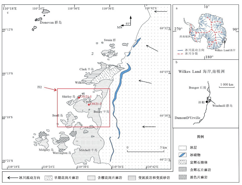
2021 Vol. 27, No. 5

Display Method:
Cover Page
2021, 27(5): .
Abstract (77) PDF (1400KB)(25)
Abstract:
Inside Cover
2021, 27(5): 封三-封三.
Abstract (78) PDF (424KB)(13)
Abstract:
Inside Cover
2021, 27(5): 封二-封二.
Abstract (101) PDF (972KB)(21)
Abstract:
Contents
2021, 27(5): .
Abstract (69) PDF (478KB)(20)
Abstract:
Chief Editor’s Address
2021, 27(5): 688-690.
Abstract (86) HTML (56) PDF (1081KB)(26)
Abstract:
Ancient cratonic nuclei in East Antarctica: Research status, problems and prospects
LIU Xiaochun, ZHAO Yue, WANG Wei, CHEN Longyao, ZHENG Guanggao, LIU Jian, WANG Yafei, REN Liudong
2021, 27(5): 691-704. doi: 10.12090/j.issn.1006-6616.2021.27.05.057
Abstract (379) HTML (142) PDF (9744KB)(59)
Abstract:
The Archean cratonic nuclei in the East Antarctic Shield (Craton) occur mainly in the Napier Mountains, southern Prince Charles Mountains, Rauer Group and Vestfold Hills in the Indian Ocean sector, and are sporadically exposed in the Australian, African and Pacific sectors. These ancient nuclei with diverse earlier crustal histories and later reworking processes are separated by the Paleoproterozoic-Early Paleozoic (Pan-African-aged) orogens. The nuclei in different sectors have a close affinity with the adjacent Gondwana continental blocks. Integrated bedrock and subglacial geological investigations and petrological and chemical studies will ascertain the temporal and spatial distributions, petrogenesis, source regions, tectonic affinities and multiple metamorphic records of the Archean rocks (materials) in East Antarctica.This can help to reveal the major history from nucleation to assembly of the East Antarctica continent, and thus to contribute to a better understanding of the early history of the Earth from an Antarctic perspective.
Research progress of the ultrahigh-temperature granulites in the Rauer Group, East Antarctica
TONG Laixi, LIU Zhao, WANG Yanbin
2021, 27(5): 705-718. doi: 10.12090/j.issn.1006-6616.2021.27.05.058
Abstract (277) HTML (139) PDF (26836KB)(47)
Abstract:
The Rauer Group (Rauer Islands), located in the eastern margin of the Prydz Tectonic Belt in East Antarctica, represents a composite high-grade metamorphic terrane consisting of Archaean and Mesoproterozoic rocks. The Mesoproterozoic rocks contain Fe-Al-rich garnet-sillimanite-bearing Filla Paragneiss associations, and have experienced two phases of metamorphism involving Grenvillian and Pan-African events. The Archaean orthogneisses contain Mg-Al-rich sapphirine-bearing ultrahigh-temperature (UHT) pelitic granulite associations (Mather Paragneiss associations), and they consist mainly of sapphirine-bearing pelitic granulite, Mg-rich garnet-sillimanite-bearing pelitic paragneiss, orthopyroxene-sillimanite quartzite, garnet-bearing mafic granulite and calcsilicate granulite that experienced ultrahigh-temperature metamorphism. In the sapphirine-bearing pelitic granulite, typical post-peak decompression textures around garnet porphyroblasts and sillimanite aggregations (kyanite pseudomorph) developed as symplectite assemblages consisting of sapphirine-orthopyroxene and sapphirine-cordierite respectively. In the garnet-bearing mafic granulite, typical post-peak 'white-eye socket' decompression texture on garnet porphyroblast also developed as symplectite composed of orthopyroxene-plagioclase. Until recently, different researchers derived distinct-type clockwise P-T paths of various peak UHT conditions and pre-peak and post-peak evolution histories, whereas different opinions also exist regarding the timing of UHT metamorphic event and tectonic setting. For example, a UHT metamorphic event was considered to occur either during the Grenvillian period (~1000 Ma) associated with a collisional orogenesis and arc magmatism or during the Pan-African period (~590 Ma or~530 Ma) related to the Prydz orogenesis and the Gondwana continent assembly. Thus, in order to clarify the metamorphic evolution history and tectonic setting of the UHT granulites in the region, further detailed studies on analyses of the mineral assemblages and metamorphic textures and the reconstruction of P-T path as well as high-precesion zircon and monazite U-Pb chronological dating are needed, and regional geological comparison should also be undertaken.
Sequence and tectonic deformation process of metamorphic complex in the Larsemann Hills, East Antarctica
HU Jianmin, WANG Wei, ZHAO Yue, LIU Xiaochun, CHEN Hong, DONG Xiaopeng
2021, 27(5): 719-735. doi: 10.12090/j.issn.1006-6616.2021.27.05.059
Abstract (410) HTML (126) PDF (46234KB)(48)
Abstract:
The Larsemann Hills are located on the eastern coast of the Prydz Bay in East Antarctica. Based on large-scale geological mapping, metamorphic complex in the Larsemann Hills was found to be layered orderly in general, and therefore, the Larsemann Group is established. The Larsemann Group is subdivided into 6 rock formations, and the protolith formation age is the Mesoproterozoic. The group has experienced the superposition of the Grenvillian and Pan-African metamorphism, and the metamorphic grade reached upper amphibolite facies to granulite facies. The main structural line in the Larsemann Hills is in the NEE-SWW strain, which generally constitutes a synclinorum structure verging to NEE. The distribution of several rock formations also shows the gradually younging from east to west. The NNW-SSE deformation of the structural line is obviously superimposed on the eastern Mirror Peninsula. The study shows that the Larsemann Group has suffered 6 periods of deformation, including the early Neoproterozoic Grenvillian period (D1), the late Neoproterozoic to early Paleozoic Pan-African periods (D2, D3, D4 and D5) and the Meso-Cenozoic extension (D6). The foliations presented in the rocks are actually the composite foliations of both the Grenvillian and Pan-African events, and the Pan-African event is demonstrated stronger than the Grenvillian event, which is rarely preserved in the gneisses. Constrained with both the metamorphic age of the Larsemann Group and the intrusion time of the Progress granite, it is believed that the D2~D5 deformations occurred during the span of 550~500 Ma. Thus, both the metamorphism and deformation features of rocks from the Larsemann Hills show that the Mesoproterozoic Larsemann Group have witnessed two orogenies of Grenvillian and Pan-African periods, respectively, and the breakup of the Gondwana.
Anatexis and enrichment mechanism of the Fe-Ti oxide minerals in the quartzofeldspathic gneisses from the Larsemann Hills, East Antarctica
REN Liudong
2021, 27(5): 736-746. doi: 10.12090/j.issn.1006-6616.2021.27.05.060
Abstract (261) HTML (157) PDF (24117KB)(50)
Abstract:
Fe-Ti oxide minerals can be locally aggregated or enriched in the quartzofeldspathic gneisses from the Larsemann Hills, East Antarctica. The enrichment is related to anatexis and subsequent high-grade metamorphism, not inherited from the protolith. The partial melting process was responsible for the residues or local enrichment of the inert Fe-Ti-Al elements and the migration of mobile components, and the volatiles were preferentially incorporated in the melt. In the water-deficient system, the local "melt" in anatexis crystallized to form the leucosomes without melt texture or minimum eutectic composition, suggesting the meta-melt feature, not real melt. The coarse leucosome or pegmatite occurred in anataxis as pre-granitic vein or body and had nothing to do with the late stage differentiation of the granitic magma. Together with the presence of the meta-melt, the substantial differentiation of the components resulted in solid residues and corresponding meta-melt phases, with the former enriched in Al, Fe elements and sillimanite, Fe-Ti oxide minerals occurred. On the contrary, the leucosomes with possible short distance migration of components were poor in Fe, Ti compositions, and seldom formed garnet and Fe-Ti oxides. The volatile-unsaturated anatexis was an essentially closed system and the total dehydration effect was not obvious. The presence of some typical minerals in high-grade metamorphism of the quartzofeldspathic gneisses, such as sillimanite, garnet, cordierite and spinel, was derived from component differentiation in partial melting of the rocks. However, the components migration was limited, and the evolving stages of metamorphism and differentiation could be preserved. Voluminous Fe-Ti oxides and sillimanite in the quartzofeldspathic gneisses suggest the possible local or differential uplifting of the area, the heterogeneity of deformation and accompanying components differentiation, corresponding to the reactivation of the earlier structures in the Pan-African event.
Microstructure and geochronology of pseudotachylite from the Hamm Peak, East Antarctica, and its geological significances
LIU Jianmin, LIU Xiaochun, ZHAO Yue, ZHANG Shuanhong, XU Gang, DONG Shuwen, MAO Qian, CHEN Bailin
2021, 27(5): 747-758. doi: 10.12090/j.issn.1006-6616.2021.27.05.061
Abstract (284) HTML (58) PDF (14937KB)(32)
Abstract:
The pseudotachylite in granulite facies granitic gneisses from the Hamm Peak, southwestern Prydz Bay, East Antarctica, occurs along the east-west-trending ductile-brittle shear zone. The characteristics of microstructure show that the pseudotachylite was formed by the frictional-melt during the rapid faulting along the paleoseismic zone. This inference is supported by the common presence of spherulites and different morphological microlites, such as skeletal, dendritic, acicular and globular in the matrix of pseudotachylite. There exist two kinds of microlite mineral assemblage. One consists mainly of hyperite and plagioclase, which developed in the northeastern part of the shear zone. The other consists of biotite, plagioclase, alkali feldspar and quartz, etc, which developed in the southwestern part of the shear zone. The occurrence of different kinds of microlite mineral assemblage indicates the differences of tectonic surrounding and stress distribution along different parts of the shear zone. Moreover, the presence of aluminous-rich hyperite may indicates the relatively high temperature and high pressure in the ambient physical condition during the pseudotachylite formation and crystallization afterwards, i.e., under the granulite facies conditions. The K-Ar age of bulk matrix of pseudotachylite is 878.1±16.8 Ma. Bulk 40Ar/39Ar step-heating release spectrum gave the varying ages mainly from 925 to 626 Ma. Combined with the regional comparison, we conclude that the pseudotachylite formed during the Grenvillian tectonic events.
Basic characteristics and metallogenic potential of banded iron formation(BIF) in the southern Prince Charles Mountains, East Antarctica
LI Miao, LIU Xiaochun
2021, 27(5): 759-767. doi: 10.12090/j.issn.1006-6616.2021.27.05.062
Abstract (416) HTML (110) PDF (9902KB)(35)
Abstract:
Banded iron formation(BIF) occurs in the lower part of the Paleoproterozoic Ruker Group at Mount Ruker, southern Prince Charles Mountains in East Antarctica. Of all depositional sequence of the Ruker Group, at least 400 m is of iron-bearing formation and 30~70 m is of ore body with an average grade of total Fe about 33.5%. The formation process of the BIF may be related to metamorphic volcanic rocks and the BIF may belong to the transitional type between the Lake Superior type and the Algoma type in genetic classification. High precision aeromagnetic survey identified two major, 10-km-wide, positive aeromagnetic anomalies extending westward from Mount Ruker for 50 km in the north and 60 km in the south, respectively. Based on the aeromagnetic anomaly and high-precision magnetic anomaly data, the prediction model and the distribution range of the BIF are established. The recoverable iron ore resources are finally estimated to be more than ten billion tons.
Zircon U-Pb ages of the mafic gneiss and leucogneiss from the Bailey Peninsula: Constraints on the timing of the tectonothermal events related to the amalgamation of Rodinia in the Windmill Islands, East Antarctica
WANG Yanbin, WANG Hao, REN Liudong, JIAO Yongyan, TONG Laixi, WILLIAMS Ian S
2021, 27(5): 768-782. doi: 10.12090/j.issn.1006-6616.2021.27.05.063
Abstract (292) HTML (71) PDF (19333KB)(32)
Abstract:
We report new geochronological data of the mafic gneiss and leucogneiss from the Windmill Islands, East Antarctica, in order to unravel the tectonothermal events related to the amalgamation of Rodinia. SHRIMP zircon U-Pb dating from the mafic gneiss (Hbl-Cpx-Opx-Bt-Pl-Qtz-Mag-Zrn) yielded early Mesoproterozoic magmatic ages of 1403±28 Ma from igneous cores, and middle Mesoproterozoic metamorphic ages of 1318±34 Ma from overgrown rims. The leucogneiss (Pl-Kfs-Qtz-Bt-Zrn) in the Bailey Peninsula has intrusive ages of 1257±51 Ma from magmatic origin zircon cores, and metamorphic ages of 1197±26 Ma from overgrown rims and/or structureless grains. The intrusive age of mafic gneiss indicates the existence of a ca.1.40 Ga igneous activity in the Windmill Islands. This is likely the earliest igneous record of the Windmill Islands, possibly relating to the final period of igneous activity of the Mawson Continent. The age of high-grade metamorphism of the mafic gneiss from the Bailey Peninsula can be constrained by the metamorphic zircon overgrowth at 1318±34 Ma, suggesting that the Windmill Islands was possibly involved in the Albany-Fraser-Windmill (East Antarctic) orogeny during the 1375~1151 Ma period. This study further supports the tectonic model in which the Windmill Islands and the Albany-Fraser Orogeny are parallel convergence during the Mesoproterozoic Rodinia amalgamation.
Petrogenesis of the Hughes Bluff granitic pluton in the Transantarctic Mountains, Antarctica
CUI Yingchun, MA Lijie, LIU Chenguang, WANG Qingchao, LÄUFER Andreas
2021, 27(5): 783-795. doi: 10.12090/j.issn.1006-6616.2021.27.05.064
Abstract (336) HTML (135) PDF (8214KB)(32)
Abstract:
In order to elucidate the petrogenesis of the Hughes Bluff granitic pluton, the petrological and geochemical studies were conducted, and the results show that the Hughes Bluff granitic pluton is composed of monzogranite, intruded by fine-grained monzogranite dikes in the later period. They both are characterized by high abundance of silicon, alkali and potassium, enriched in Rb, Th, U and K and depleted in Nb, Ta, Nd and Ti relative to those of the primitive mantle, with the Rittmann Indexes less than 3 and the A/CNK values less than 1. They both also have a low total amount of rare earth elements and an abundance of light rare earth, showing weakly negative Eu anomaly and slightly positive Eu anomaly in the chondrite-normalized REE pattern for the monzogranite and granitic monzogranite dike respectively. All the data show that the rocks from the Hughes Bluff granitic pluton belong to the I-type granites, and the source region is probably the lower continental crust, but the contribution of mantle material cannot be ruled out. The magma in the source region underwent varying degrees of fractional crystallization of plagioclase, ilmenite, rutile and apatite, and was derived from a volcanic island arc environment related to subduction.
Detrital zircon age from the glacial and littoral deposit, Northern Victoria Land, Antarctica: Implications for the timing of magmatic activity of the Ross Orogeny on the Gondwana continental margin
CHEN Hong, WANG Honghui, BAO Guodong
2021, 27(5): 796-808. doi: 10.12090/j.issn.1006-6616.2021.27.05.065
Abstract (323) HTML (143) PDF (36440KB)(24)
Abstract:
The Transantarctic Mountains across the central Antarctic continent are the Ross orogenic belt formed by westward subduction of the Paleo-Pacific underneath the East Gondwana active continent margin in the early Paleozoic. The sedimentary, deformation and metamorphism, and granitic magmatic intrusion in this stage represent the process of the Ross Orogeny. Due to the significant difference in age among the three elements mentioned above, there is no precise time defined on the Ross Orogeny. In this paper, detrital zircon U-Pb dating of gravel and sand samples from moraines and coastal sediments in the Inexpressible Island of Northern Victoria Land was carried out. The ages of four samples with different gravel diameters range from 2443 to 323 Ma and are mainly concentrated between 530~450 Ma, with a peak age of~485 Ma. Most of the zircons show oscillatory zoning in CL images and have Th/U ratios great than 0.1 (mainly>0.4), with REE characteristics indicating a magmatic origin. Therefore, these ages reflect the timing of magmatic activity in the provenance of the loose sediment samples. The age composition of detrital zircons is consistent with the age of magmatic intrusion, intracontinental deformation and depositional stratigraphy in the surrounding areas, suggesting that the magmatic activity in the Northern Victoria Land and its surrounding areas might have lasted up to 450 Ma in the intracontinental deformation stage, which may represent the end time of the Ross Orogeny. These results provide a new constraint for the tectonic evolution of the Ross Orogeny on the Gondwana continental margin.
Geophysical characteristics of the Terror Rift, West Antarctica
ZHANG Qiao, JI Fei
2021, 27(5): 809-820. doi: 10.12090/j.issn.1006-6616.2021.27.05.066
Abstract (288) HTML (91) PDF (28627KB)(29)
Abstract:
In this paper, we investigated the Terror Rift where the last stage of Cenozoic rifting in the West Antarctic Rift System (WARS) took place. The International published and domestic sampled during CHARE seismic reflection profiles are utilized. Combining with drilling data, all the stratigraphic reflections are identified and unified in the entire study area for the subsequent interpretation. The rift fault patterns in the study area can be divided into syn-sedimentary faults, intra-layer faults and negative flower structure. According to faulting, we delineated the east and north boundary of the Terror Rift. Moreover, Cenozoic faulting activities are divided into three stages with strongly inheritance between each one of them. The timing of faulting activities gradually becomes younger from the Adare Basin in the north to the Terror Rift in the south, which is attributable to the transmission of rifting from north to south. In order to further reveal the geophysical characteristics of the study area, we investigated effective elastic thickness (EET) based on the fan wavelet transform technique. The anomalously low EET anomalies observed in the front of the Transantarctic Mountains(TAMs) is related to the rifting and magmatism in the late Cenozoic, probably indicating the extensional area of the western Ross Sea.
Magmatism and tectonic evolution of West Antarctica
ZHENG Guanggao, LIU Xiaochun, ZHAO Yue, PEI Junling
2021, 27(5): 821-834. doi: 10.12090/j.issn.1006-6616.2021.27.05.067
Abstract (276) HTML (92) PDF (4407KB)(55)
Abstract:
West Antarctica is mainly composed of five distinct micro-continental blocks, namely Haag Nunataks, Antarctic Peninsula, Thurston Island, Marie Byrd Land and Ellsworth-Whitmore Mountains. In order to understand the geological evolution of West Antarctica, this paper presents a brief overview of the main magmatic events of the five blocks and their tectonic significance. The oldest rock is the Precambrian orthogneiss from Haag Nunataks with zircon U-Pb age of~1238 Ma, indicating the development of Mesoproterozoic arc magmatism in West Antarctica. The other four blocks preserve the geological records since~500 Ma. During the Paleozoic, the Ellsworth-Whitmore Mountains block was formed in a rapidly subsiding continental rift basin environment which was related to the back-arc extension caused by the Ross Orogeny, and the magmatic activity was rare. A set of convergence-related magmatism occurred in the middle to late Paleozoic in Mary Byrd Land block, which was formed in an active continental margin environment. The Antarctic Peninsula-Thurston Island blocks record the development of the Carboniferous-Permian arc during this time. During the Mesozoic, the tectonic setting of these blocks began to differentiate since the Jurassic. The Ellsworth-Whitmore Mountains block records Jurassic intra-plate magmatism, which may be associated with large igneous province. In Marie Byrd Land, the lithology changed from Ⅰ-type arc magmatic rocks to A-type alkaline magmatic rocks in the Jurassic-Early Cretaceous to the mid-Cretaceous period. This reflects a major change in tectonic setting from subduction to rifting during the mid-Cretaceous. The Jurassic-Cretaceous flare-up in arc magmatism record on the Antarctic Peninsula-Thurston Island blocks with a pulse of Jurassic large igneous provinces. These are the product of the interaction of continuous subduction and rifting. The Cenozoic magmatism was represented by the Antarctic Peninsula block with arc magmatism continuing until the Eocene. The temporal and spatial distribution of the arc magmatism was related to the subduction and collision of spreading ridge which was cut into several segments by sinistral transform faults.
Progress in Mesozoic-Cenozoic paleomagnetism and plate reconstruction of West Antarctica
GAO Liang
2021, 27(5): 835-854. doi: 10.12090/j.issn.1006-6616.2021.27.05.068
Abstract (416) HTML (115) PDF (18560KB)(57)
Abstract:
In this study, we summarized paleomagnetic data from West Antarctica and reconstructed the paleoposition of different crustal blocks of West Antarctica. Plate reconstructions identified two widely influenced tectonic events in West Antarctica due to the subduction of the Pacific Plate, including the rapid southward drift of Thurston Island-Eights Coast and Eastern Marie Byrd Land during the eruption of Ontong Java-Manihiki-Hikurangi Large Igneous Provinces and related peak global ocean crust production rate at 120~100 Ma; The lithospheric extension in the Ross Sea region and rapid separation of Thurston Island-Eights Coast and Marie Byrd Land from East Antarctica, as well as the southward drift and clockwise rotation of the Antarctic Peninsula due to the subduction of Pacific-Phoenix Ridge under the Ross sea region at~100 Ma. This supports a co-evolution of the tectonic process between the Pacific Plate subduction and the plate motion in West Antarctica. In the future, we need more reliable paleomagnetic data with precise age constraints to make a more detailed reconstruction of different tectonic processes of West Antarctica. This will help us in understanding the geological evolution of Antarctica, and the geodynamics mechanism of plate growth and plate separation.
Cenozoic paleontological characteristics and paleoenvironment of King George Island, West Antarctica
WEI Lijie
2021, 27(5): 855-866. doi: 10.12090/j.issn.1006-6616.2021.27.05.069
Abstract (344) HTML (214) PDF (13447KB)(36)
Abstract:
A set of high-K and low-Al tholeiites intercalated with volcanic clastic rocks developed in King George Island (Western Antarctica), belonging to the island arc volcanic rock series. Moreover, the longest record of glacial deposition in Antarctica is preserved on the island, which provides the important evidence of the Antarctic Ice Sheet evolution. Fossils of plant leaves, sporopollen, stems, invertebrate animals and bird footprints which were abundantly found in the outcropped Cenozoic continental strata of King George Island, started to decrease from the Eocene to the early Miocene, showing an obvious downward trend of plant diversity, and the surviving sparse vegetation was only the tundra species around the glacier. The studies of ice marine strata and paleontology suggest that the late Oligocene marine strata mainly correspond to high-energy environment and the early Miocene marine strata correspond to low energy environment. This paper explores the Cenozoic paleontological characteristics and paleoenvironment of King George Island, and the investigations allow us to understand the trend of paleontological diversity and provide evidence for the reconstruction of the Antarctic paleoenvironment as well.
Impact of Cenozoic Antarctic continent-ocean configuration patterns on global climate change
PEI Junling, ZHAO Yue, ZHOU Zaizheng, YANG Zhenyu, LIU Xiaochun, ZHENG Guanggao, TONG Yabo, LI Jianfeng, HOU Lifu
2021, 27(5): 867-879. doi: 10.12090/j.issn.1006-6616.2021.27.05.070
Abstract (400) HTML (374) PDF (17270KB)(78)
Abstract:
Antarctica recorded a Cenozoic geologic history of continental growth, breakup and dispersal, global cooling and the development of continental-scale Antarctic ice sheet. Despite the importance of Antarctica, there has not been an integrated view of the Cenozoic tectonic evolution of the region as a whole. In this Review, we identify the Tasmania gateway and Drake Passage, and present their overlapping and interconnected tectonic, magmatic and sedimentary history of Antarctica, South America and Australia. Antarctic Circumpolar Current (ACC), which occurred in the late Eocene to early Oligocene, was most impacted by the opening history of Drake Passage and the Tasmania gateway. Our comprehensive analysis and contrastive study show that the beginning of ACC corresponds to the transition from "warmhouse" to "coolhouse" phase at 34 Ma, indicating the development of ACC was controlled by the tectonic gateways, which in turn affected global climate. We conclude by briefly summarizing the Cenozoic geologic history of the Antarctic system as a whole, and how it provides insight into continent-ocean configuration patterns and what key topics must be addressed by future research are disscussed as well.
Polar Silk Road and Arctic petroleum and gas resources
ZHAO Yue, LIU Jianmin, HAN Shuqin, WEI Lijie
2021, 27(5): 880-889. doi: 10.12090/j.issn.1006-6616.2021.27.05.071
Abstract (403) HTML (59) PDF (15422KB)(44)
Abstract:
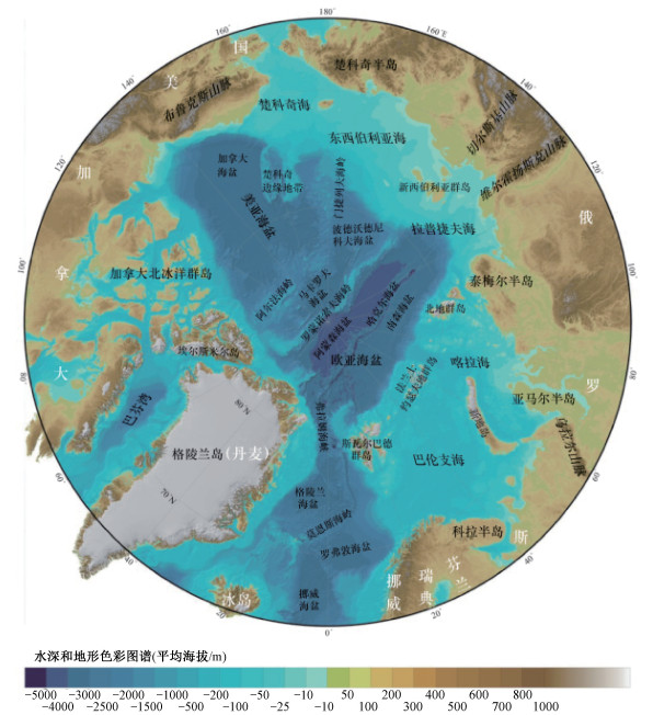
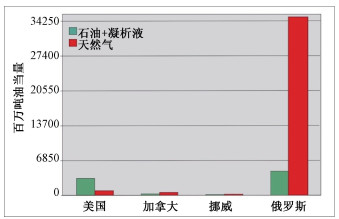
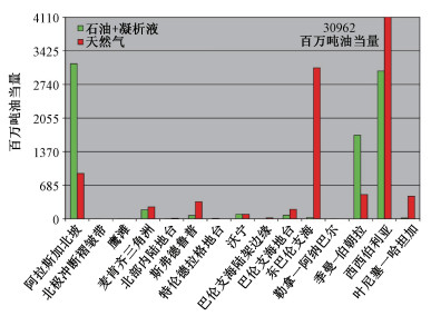
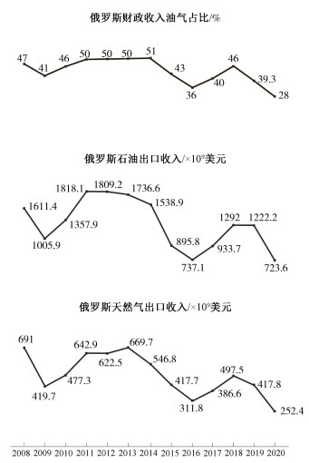
Petroleum and gas are important strategic resources, among which natural gas as a clean energy resource has always been and still will be the most important energy resource in the foreseeable future, even after cutting global carbon emissions and China peaking carbon emissions. Diversification of energy import channels has been one of the effective measures to alleviate the energy shortage in China. The Arctic region is rich in oil and gas resources and is dominated by natural gas. The vast majority of oil and gas resources found in the Arctic are in Russia, but now more than 80 percent of the Russian natural gas production is already in their oil and gas fields in north Arctic Circle. In 2012, China and Russia officially launched a joint project to develop liquefied natural gas, marking significant progress in China's participation in the development and utilzation of Arctic oil and gas resources, and in fact started the cooperative process to integrate the China-led "Construction of the Silk Road Economic Belt"and the later Russia-led "Construction of Eurasian Economic Union".The total amount of oil and gas resources discovered in the Arctic region is 328.94 billion barrels of oil equivalent, of which oil equivalent amounts to 60.54 billion barrels (8.41 billion tons), only accounting for 2.5% of the world's discovered oil resources; Natural gas amounts to 41.4 trillion cubic meters (268.3 billion barrels, 37.26 billion tons of oil equivalent), and accounts for 15.5 percent of the world's discovered natural gas resources. The vast majority of oil and gas resources discovered in the Arctic region are in Russia, which has a total of 290.5 billion barrels of oil equivalent (40.35 billion tons), accounting for 88.3%, of which natural gas amounts to about 39.47 trillion cubic meters, about 255.79 billion barrels (35.53 billion tons) of oil equivalent, constituting more than 95% of the total discovered natural gas resources in the Arctic. The Arctic also has considerable undiscovered oil and gas resources, accounting for about 15% of the world's total undiscovered amount; The undiscovered natural gas, which mainly distributes in Russia, accounts for 30% of the world's total undiscovered amount. In the context of global warming and crackdown by the US-led Western world, Russia is bound to increase extraction and development of Arctic oil and gas, especially natural gas, and transport them through the Arctic Shipping Lanes to China and other consumer countries, in order to secure its natural gas export revenue and fiscal revenue. This paper takes as the basis the summary of the distribution characteristics of oil and gas resources in the Arctic, oil and gas resources and the Arctic strategy of Russia, and the traffic capacity of the Northern Sea Route (NSR), and reviews the launch and development of the liquefied natural gas joint project as well as the international power politics environment. Moreover, this paper briefly introduces the process of China's successful intervention in the Arctic oil and gas resources project, and puts forward the strategic measures for China to utilize Arctic oil and gas resources.
Prospects and directions of China's participation in the development and utilization of oil and gas resources in the Arctic
DU Xingxing, LIU Jianmin
2021, 27(5): 890-898. doi: 10.12090/j.issn.1006-6616.2021.27.05.072
Abstract (519) HTML (145) PDF (1348KB)(51)
Abstract:
The rich oil and gas resources in the Arctic have attracted worldwide attention in recent years. According to the academically accepted assessment by the United States Geological Survey, the Arctic oil and gas resources are unevenly distributed, mainly concentrated in Russia, Alaska (the USA), Norway, Canada and Greenland. The exploration and development of oil and gas resources show different characteristics in different countries and regions, which may change under new circumstances. China is a big consumer and importer of oil and gas resources, and the Russian Arctic Region is becoming one of the China's important oil and gas suppliers. This paper presents the current development and utilization status of Arctic oil and gas resources in major Arctic Nations and the future development prospects. Based on China's current participation in oil and gas development and utilization in the Arctic, this paper concludes by suggesting that China should take Russia as a long-term partner in the Arctic oil and gas resources development and the two sides should carry out cooperation in various fields, including project investment, technology investment and channel construction.