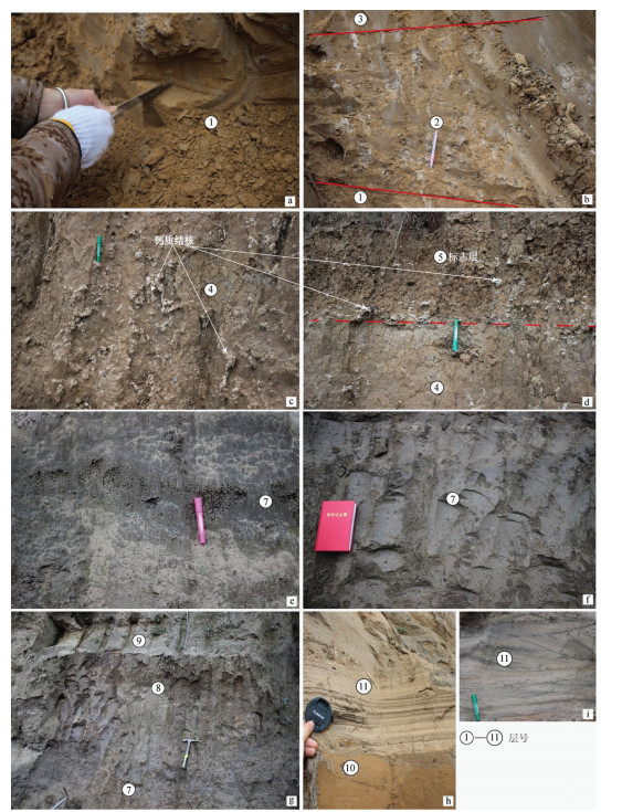
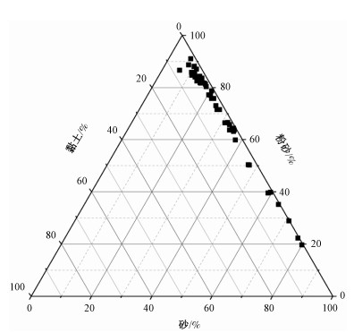
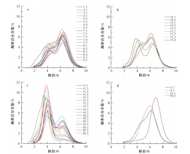
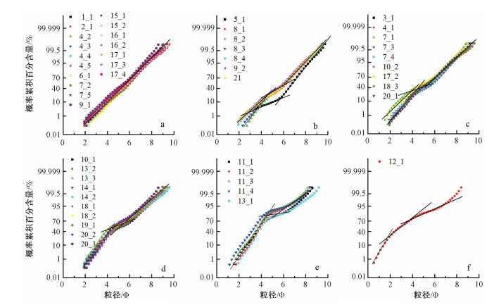
2021 Vol. 27, No. 6

Display Method:
Characteristics and causes of coseismic surface rupture triggered by the "5.22" MS 7.4 Earthquake in Maduo, Qinghai, and their significance
GAI Hailong, YAO Shenghai, YANG Liping, KANG Taibo, YIN Xiang, CHEN Ting, LI Xin
2021, 27(6): 899-912. doi: 10.12090/j.issn.1006-6616.2021.27.06.073
Abstract (1255) HTML (391) PDF (70955KB)(166)
Abstract:
An MS 7.4 earthquake occurred in Maduo County, Guoluo Tibetan Prefecture, Qinghai Province at 02:04 on May 22, 2021(Beijing time), which is the largest one in China after the 2008 Wenchuan MS 8.0 earthquake. Finding out the distribution and characteristics of its coseismic surface rupture in time is of great significance for the identification of seismogenic structure, regional earthquake prevention and disaster reduction. Combining the post-earthquake field investigation with the results from the interpretation and analysis of high-resolution satellite remote sensing images, aftershock data and UAV low altitude photogrammetry, we got a preliminary judgment on the characteristics of six typical seismic surface ruptures. Firstly, the surface rupture caused by the Maduo earthquake is mainly distributed along the southeastern segment of the known South Branch of the East Kunlun fault zone, the kunlunshankou-Jiangcuo fault. It indicates that the Jiangcuo fault should be the seismogenic fault of the earthquake. Secondly, the western segment of the coseismic rupture with an overall strike of 275°~300°, is mainly manifested as an inclined combination of compressive bulges and echelon tensile fractures. There is a significant vertical displacement of 1.4~0.8 m between the Jiangcuogongma section and the Jiangduocun section, indicating that the western segment may have obvious normal fault components. The huanghexiang section in the middle is mainly composed of a series of NW-trending P shear fractures with left-order oblique and NE-trending tensile fractures with right-order en echelon, with small strike slip displacements. The Changma reach of the North Branch is mainly composed of a series of en echelon fractures, with the overall strike of 260°, The strike of the fault is obviously different from that of the western segment of the fault. Thirdly, the maximum left lateral displacement caused by the earthquake occurred in the Cuoerjiala rapture section of the western segment, about 2.8 m, indicating that the strike slip displacement of the surface fracture zone of the earthquake is mainly characterized by unilateral expansion attenuation from west to East. The fact that the Maduo earthquake occurred in the Bayan Har block on the south side of the East Kunlun main fault demonstrate the possibility of earthquake with magnitude 7 or above in this block. Therefore the seismogenic conditions and mechanism of strong earthquake activity in the Bayan Har block should be a scientific issue that needs further attention.
Late Cenozoic development characteristics and dynamic mechanism of the main faults in the Midu area, northwestern Yunnan[BP(]Development characteristics of the main faults of the late cenozoic in the Midu area, northwestern Yunnan, and their dynamic mechanism
HUANG Xiaolong, WU Zhonghai, WU Kungang
2021, 27(6): 913-927. doi: 10.12090/j.issn.1006-6616.2021.27.06.074
Abstract (1069) HTML (352) PDF (54214KB)(129)
Abstract:
The Midu area is located at the southeast end of the northwestern Yunnan fault depression zone, the intersection of the Red River fault zone and the Chenghai fault. It is a key area for uncovering the formation mechanism of the Northwest Yunnan fault depression zone as well as its kinematic relationship with the Red River fault zone. Based on remote sensing interpretation and field investigation, we found five faults in the study area, namely the NE-trending Maolipo fault, NW-NNW-trending Fengyi-Dingxiling fault, Midu fault, Mizhi fault and Yinjie fault. We made statistical analysis of the fault slipping geological-landscape bodies and slickensides, and the results are produced in three aspects. Firstly, the Maolipo fault are mainly characterized by left lateral strike-slip activity with normal fault component in Quaternary. Secondly, the arc-shaped Midu fault and the NW-trending Yinjie fault are dominated by normal fault activity in Quaternary. Thirdly, during the Pliocene the Fengyi-Dingxiling fault was characterized by dextral strike-slips, while the Mizhi fault by extensional normal faults, and there was no obvious activity in both faults during the Quaternary. We inferred both from the geometry and kinematics of the main faults in the Midu area and the activity evolution of the Red River fault zone that, in the Late Cenozoic the main Quaternary active faults, such as the Midu fault and Yinjie fault, were formed on the basis of inheriting and remaking the original fault trace of the Red River fault zone. These active faults controlled the distribution of the Midu basin. The fault activity and transtensional deformation in the Midu area and the Northwest Yunnan fault depression zone during the Pliocene or even earlier could be affected by the extensional deformation at the end of the Red River fault zone. However, during the Quaternary the Chenghai fault basically controlled the development of main active faults in the Midu area. The crustal transtensional deformation in this period might be driven by the clockwise rotation of the Sichuan-Yunnan inner arc belt and the regional strike-slip pull-apart caused by the Nantinghe fault, Wanding fault and Litang fault.
The gravity field and tectonic features in the southeast of the Anza Basin, Kenya
CHEN Qing, YUAN Bingqiang, HUANG Xiaoyu, LI Junmei, CHEN Hao, DING Chengyi, SUN Shuai, QIN Wen
2021, 27(6): 928-937. doi: 10.12090/j.issn.1006-6616.2021.27.06.075
Abstract (368) HTML (166) PDF (10076KB)(42)
Abstract:
The southeast of the Anza Basin in Kenya, located in the East African Rift System, has developed a very thick Mesozoic and Cenozoic sedimentary cover. However, the low level of exploration in this area restricts us from understanding its structural system and evaluating its oil-gas exploration potential. In this study, we processed and interpreted the gravity anomaly data obtained from the study area based on our understanding of its structural characteristics, and the conclusions drawn from the results are as follows. Under the influence of dextral shear stress of the central Africa shear zone, large-scale NW-oriented basement faults and small-scale NE-oriented caprock faults developed in the study area with the latter cutting off the former. The basement depth of the study area varies greatly and is characterized by "one uplift between two depressions". The very thick Mesozoic and Cenozoic cover layer was deposited in depressions. Controlled by the NW-tensional fault as well as the NE-fault developed along the structural weak zone, the study area is divided into four tectonic units: the eastern depression, the central uplift, the southern uplift and the western depression, showing the structural pattern of the "east-west zone and north-south block".
Application of seismic detection by spark source for concealed faults in Shanghai urban water network area
SONG Chunhua, SHI Gang, WU Hong, ZHANG Hao, YU Fei
2021, 27(6): 938-948. doi: 10.12090/j.issn.1006-6616.2021.27.06.076
Abstract (626) HTML (209) PDF (29474KB)(57)
Abstract:
Nowadays artificial seismic exploration is recognized as one of the most effective means to detect hidden faults in urban areas. However, good seismic exploration data in highly urbanized areas is often unavailable limited by the excitation source and strong interference. In this paper, a seismic detection of excitation mode of high-power spark source was carried out in the Dazhi River area, in view of the developed urban water network in Shanghai. We did comparison tests on elements such as energy excitation of spark source, water depth of discharge and seismic imaging effects of different sources, and obtained the best excitation parameters for seismic exploration in inland river areas (east section of Dazhi River) in Shanghai. The validity of seismic exploration by spark source in urban water network is confirmed. Compared with other conventional excitation methods, EDM seismic exploration data has higher signal-to-noise ratio and can reach a deeper exploration depth, which helps to get good results from the detection of hidden faults in urban areas.
DEM in quantitative analysis of structural geomorphology: application and prospect
CAO Pengju, CHENG Sanyou, LIN Haixing, WANG Xi, LI Manqi, CHEN Jing
2021, 27(6): 949-962. doi: 10.12090/j.issn.1006-6616.2021.27.06.077
Abstract (1095) HTML (160) PDF (2012KB)(171)
Abstract:
Digital elevation model (DEM) is used to realize the digital simulation of terrain surface (i.e. the digital representation of terrain surface shape) through the limited terrain elevation data. As a new tool to describe the terrain, it provides a new field of vision for people to study the evolution process of the earth's surface. The application status of DEM in many fields are summerized in this paper, including basic topographic factors, watershed geomorphological features, reconstruction of paleogeomorphology, tectonic geomorphological development model, tectonic activity classification, geomorphological classification and environmental assessment, geomorphological parameter algorithms and computing platform development. Our research generally focuses on land, with river geomorphology and mountain geomorphology as the main objects. The research process changes from the early qualitative description of geomorphology to the semi-quantitative and quantitative analysis of a variety of geomorphological parameters. The research scale extends from a small watershed to the whole orogenic belt in space and from a few hours to millions of years in time. However, many factors can influence the accuracy of quantitative analysis results of tectonic geomorphology, such as the uncertainty of the time series of tectonic geomorphology evolution, the complexity of the acquisition of geomorphological parameters, the diversification of terrain model algorithms and the error factors in the process of DEM generation. Therefore, while summarizing the previous research results, some thoughts are given on the application of DEM in tectonic geomorphology.
Natural gas distribution and reservoir-forming law of the Yinggehai Basin, China
WU Xunda, LIAO Jin, SUN Wenzhao, LIU Ping, LI Chunlei
2021, 27(6): 963-974. doi: 10.12090/j.issn.1006-6616.2021.27.06.078
Abstract (548) HTML (180) PDF (29350KB)(68)
Abstract:
Oil-gas exploration in the Yinggehai basin shows, the formation, distribution and preservation of oil and gas resources are closely related to the overpressure system in the diapir zone. We based our analysis of the characteristics of generation, migration and reservior-forming of oil and gas resources on a full integration of geological logging and seismic data as well as drilling outcomes in the Yinggehai basin. Our research results show that the distribution of natural gas, is generally characterized by shallow gas reservoir along the central mud diapir zone and middle deep lithologic gas reservoir along the limb of diaper zone. The reservior-forming and enrichment follows the law of "driven by overpressure, conduction via fracture of diapir, enrichment in fan deposit possessed by gravity flow, capping with high pressure mudstone, pool-forming of episodic water-soluble gas ".
A KronosFlow software-based preliminary study on the tectono-thermal evolution of thrust-nappe belt
LI Dan, CHANG Jian, LI Chenxing, YAO Tongyun, LIU Minzhu
2021, 27(6): 975-986. doi: 10.12090/j.issn.1006-6616.2021.27.06.079
Abstract (496) HTML (134) PDF (12760KB)(62)
Abstract:
Basin modeling is an essential technical method for the exploration and assessment of petroleum basins. However, traditional 2D basin modeling technologies only apply to extensional basins. This makes the thermal history reconstruction in lateral direction of compressional basins an unsolved problem and thus restricts oil and gas exploration. The latest KronosFlow software developed by the French Beicip-Franlab company breaks through the above limitations of traditional softwares on complex structures such as thrust-nappe belts, salt structures, mud diapir structures, and precisely controls the lateral and vertical structural displacements. We restored the burial history, thermal history, hydrocarbon generation, expulsion history, and hydrocarbon migration and accumulation history of compressional basins, by tracking the continuous motion pattern of a single grid, restoring lateral deformation and seamlessly interacting with the TemisFlow software. We then used the KronosFlow software on the Kalpin and Kuqa thrust-nappe belts in the northern margin of the Tarim Basin for quantitatively inverting the tectonic-thermal evolution history of the thrust-nappe belts since the Cenozoic. The modeling results were consistent with the measured paleo-thermal indicator data, confirming the validity of the results of this software for the compressional basin. The Yimugantawu fault in the Kalpin thrust-nappe belt was reactivated during 40~30 Ma, and the temperature of the Silurian-Devonian near the fault was higher than 85℃. The Kepingtag fault was active during 15~10 Ma, and the formation temperature was lower than 70℃. The Cambrian (maturity of source rocks between 1.3%~1.7%) and Ordovician (maturity of source rocks between 0.7%~1.2%) source rocks have a high degree of thermal evolution and strong hydrocarbon generation ability. The temperature of the Jurassic strata in the Kuqa thrust-nappe belt ranges from 50 to 70℃ in the northern section and 210 to 230℃ in the southern section. The salt structure results in geothermal anomaly, among which the salt rock in the Qiulitage structural belt is the thickest and the cooling effect is the most obvious.
Application of audio magnetotelluric method in prospecting for deep hidden manganese ore: A case study in the Pujue manganese mine in Songtao, Guizhou, China
SHEN Xiaoqing, YANG Bingnan, HE Shuai, ZHANG Deshi
2021, 27(6): 987-997. doi: 10.12090/j.issn.1006-6616.2021.27.06.080
Abstract (433) HTML (69) PDF (14553KB)(42)
Abstract:
The Pujue manganese deposit is a typical Datangpo-type sedimentary deposit of Nanhua period in eastern Guizhou. In the Pujue mining area the early-formed sedimentary manganese deposits were significantly influenced by the subsequent structures in aspects of burial and preservation. Analyzing the deep tectonic framework and its relationship with the manganese-bearing rock series is of great importance to the ore-prospecting prediction and deep exploration of the manganese deposits in the area as well. Our aim is to find out the spatial distribution of metallogenic geological bodies and fault structures and their relationship in the Pujue Manganese mining area. We used audio magnetotelluric method to study the characteristics of underground electrical structure and tectonic framework in the area, and built a theoretical model similar to the geoelectric structure of the study area based on the physical property analysis. Through inversion calculation under different schemas, we gave preference to a two-dimensional inversion method of nonlinear conjugate gradient TM model, which is suitable for Occam-TE one-dimensional inversion as the initial model. We used the above inversion method to invert the measured data from the area, and thus identified the spatial distribution characteristics between the tectonic framework and the manganese-bearing rock series and their contact relationship. It demonstrates that the fault F0 hasn't damaged the manganese-bearing rock series in the deep. Our research results show that AMT is of great significance in guiding the deep prospecting prediction in the Pujue manganese mining area and its adjacent areas.
Assessment of seismic liquefaction hazard in Shanghai based on ground motion intensity and Standard Penetration Test
LI Xue, ZENG Yuyan, YU Fei, SHI Gang
2021, 27(6): 998-1010. doi: 10.12090/j.issn.1006-6616.2021.27.06.081
Abstract (505) HTML (215) PDF (17184KB)(54)
Abstract:
Shanghai is located in the alluvial plain of the Yangtze River Delta, the merge area of the Huangpu River and Suzhou River. The unique geographical and sedimentary environment have formed the shallow sand layers in Shanghai. Due to the significant urbanization process in Shanghai, geological hazard analysis, particularly the assessment for seismic liquefaction hazard in the Shanghai urban area has become an subject to be studied urgently. In this paper, we presented a regional liquefaction hazard analysis model. Based on the borehole Standard Penetration Test (SPT) data and regional Peak Ground Acceleration (PGA) zonation of the Shanghai area, we analyzed liquefaction risks with different probability of exceedance in 50 years. As our results indicated, under the condition that earthquake with 10% probability of exceedance in 50 years happens, more than 66.0% of the land area in Shanghai will not be affected by earthquake-induced liquefaction, 21.8% will only surfer modest liquefaction, and only 12.3% has the risks of serious liquefaction. These places cover Chongming island, Hengsha island, Changxing island and the banks of the Huangpujiang River and the Suzhou River. Provided that earthquake with 2% probability of exceedance in 50 years happens, due to the overall increase of peak ground motion acceleration, not less than 46.25% of the land area may suffer from modest to serious liquefaction risks. Although the rare seismic liquefaction risks exist, the probability of that is quite low. The current high fortification intensity for Shanghai in Chinese Code for Seismic Design of Building may result in unnecessary cost of construction. Our study provides new ideas and suggestions for perfecting the Code for Seismic Design of Building for Shanghai.
Late Quaternary depositional characteristics and environment significance of the Xibozhang section in Baoding, central Hebei Plain, China
LIU Zhirong, XUE Huaiyu, WANG Changsheng
2021, 27(6): 1011-1023. doi: 10.12090/j.issn.1006-6616.2021.27.06.082
Abstract (763) HTML (205) PDF (35468KB)(80)
Abstract:
This paper aims to ascertain the depositional paleoenvironment since the late Quaternary in the central Hebei plain. We measured the 20.74 m-deep Xibozhang section and analyzed the collected samples for grain size and optically stimulated luminescence (OSL) tests. OSL dating results indicate that the deposits were formed during 102~8.67 ka, belonging to the late Pleistocene to early Holocene. Analysis of lithology and grain size show that, the section is fluvial deposit with typical binary structure, which can be further divided into channel deposit and floodplain deposit. The channel deposits are mainly medium-coarse sand containing mica fragments, with oblique bedding. Frequency curves is characterized by positive bias bimodal with moderate to poor sorting, and the probability cumulative curves are mainly two-stage dominated by jump components. The floodplain deposit is mainly clayey silt with well-preserved shell fossils and calcareous nodules. Most frequency curves are negative bias bimodal with poor sorting, and the probability cumulative curves are mainly two-stage dominated by suspension components. The C-M diagram shows that the Xibozhang section consists largely of uniformly suspended deposits, belonging to typical meandering river deposits. Comparing the measured section with the loess section of Jingyuan, we found that the Xibozhang section could be divided into three stages from the bottom up. The lower part, 16.14~20.74 m, is the deposits of the late stage of the last interglacial period, with warm and humid climate, dominated by silty deposits; The middle part, 3.18~16.14 m, is the deposits of the last glacial period, with dry and cold climate. The grain size shows the fine-coarse-fine characteristic, individually corresponding to the early interglacial stage, interglacial stage and maximum glacial stage of the last glacial period; The upper part, 0.2~3.18 m, is the deposits of the post glacial stage with similar characteristics of 16.14~20.74 m, dominated by clay and clayey silty sand deposits. Grain size analysis reveals that the late Quaternary depositional environment of the Baoding depression in central Hebei Plain is mainly of fluvial environment, and the distribution of grain size stage is the material respond to glacial-interglacial climate.
Provenance study on geochemical elements of detrital K-feldspar in Quaternary gravel layer in Yichang and its geological significance
LIN Xu, LIU Haijin, WU Zhonghai, LIU Weiming, ZHANG Yang, CHEN Jixin
2021, 27(6): 1024-1034. doi: 10.12090/j.issn.1006-6616.2021.27.06.083
Abstract (454) HTML (149) PDF (15674KB)(52)
Abstract:
The Yichang area located at the exit of the Three Gorges is covered with a set of thick Quaternary gravel layers, recording the evolution of the paleoenvironment and the formation of the Yangtze River. However, there has been a great dispute over the time when the Yangtze River materials in the upper reaches entered the western margin of the Jianghan Basin. K-feldspar is a common mineral in fluvial sediments, and its geochemical element compositions are significantly different in different regions, making it an ideal mineral for the fluvial provenance study. In this case, we utilized the laser ablation inductively coupled plasma mass spectrometry (LA-ICP-MS) to analyze the elementary compositions of detrital K-feldspar grains (n=340) on the gravel layers of the Yichang area and the upper reaches of the Yangtze River. In combination of principal component analysis (PCA) with formation sedimentary ages of gravel layers, we discussed the time when they established the provenance connection. The results show that the provenance connection has been established since 1.15 Ma and a new provenance area appeared at 0.75 Ma, suggesting that the Yangtze River drainage was strongly influenced by the East and South Asian summer monsoon during the period of 1.2~0.7 Ma.
Quaternary sedimentary sequence and sedimentary environment restoration in the Jinzhong Basin, Fenhe Rift Valley
QIN Bangce, FANG Weixuan, ZHANG Jianguo, JIA Runxing, XIAO Wenjin
2021, 27(6): 1035-1050. doi: 10.12090/j.issn.1006-6616.2021.27.06.084
Abstract (488) HTML (210) PDF (46288KB)(55)
Abstract:
Jinzhong Basin is a Cenozoic intracontinental faulted sedimentary basin located in the middle of Fen-Wei graben system. Our study aims to identify the Quaternary sedimentary sequence and reveal the Quaternary sedimentary environmental evolution of the Jinzhong Basin. We used structural petrography to survey the Quaternary sediments and sedimentary environment on the surface and in the boreholes of the Jinzhong Basin. The results shows: The surface Quaternary sedimentary sequence in the Qingxu area of the Jinzhong Basin is composed of the river bed facies and floodplain facies of the Tuoyang Formation in the basin-the fluvial facies of the Fenhe Formation at the basin edge-the fluvial facies of the Zhiyu Formation, alluvial fan facies of the Fenhe Formation and aeolian facies of the Malan Formation in the basin-mountain transition zone-Permian neritic facies in the bedrock mountain (the periphery of the basin). The Quaternary sedimentary sequence in the core of the borehole is composed of the shallow lake facies and lakeside facies of the Lower Pleistocene-the shallow lake facies and fluvial facies of the Middle Pleistocene-the fluvial facies and alluvial fan facies of the Upper Pleistocene-the alluvial fan facies of the Holocene. The study suggests that the sedimentary sequence and environmental evolution of the Jinzhong basin is the early Pleistocene continental lake basin sediment-the Middle Pleistocene shrunken lake-the late Pleistocene strongly shrunken lake and river-the Holocene re-subsidence terrestrial lake pots. From the center to the mountain the sedimentary environment of the continental lake basin can be divided into lake sediment-river and lake sediment-alluvial fan sediment(the mountain mouth area at the edge of the basin).The dislocation of Upper Pleistocene sediments in the basin-mountain transition zone was caused by syn-sedimentary active faults. The fault activity reveals the dynamic mechanism of stepped formation in the Jinzhong Basin. These findings provide new evidence for the study of regional climate, environmental changes and regional tectonics in the Jinzhong Basin as well as reference for the site selection of Taiyuan City.
The age sequence of the detrital zircons from the Guanyindian section in Longde, the northeastern margin of the Tibetan Plateau, and its geological significance
KOU Linlin, LI Zhenhong, DONG Xiaopeng, CUI Jiawei, LI Hailong
2021, 27(6): 1051-1064. doi: 10.12090/j.issn.1006-6616.2021.27.06.085
Abstract (544) HTML (212) PDF (16990KB)(128)
Abstract:
The precise age of the strata at the northeastern margin of the Tibetan Plateau in the Paleogene-Neogene, and the initial time when the uplift of the Plateau affected its northeastern margin, have always been two main bone contentions among geologists. The Guanyindian section at the northeastern margin of the Tibetan Plateau is our research subject. We gain new insights to the two mentioned issues by using detrital zircon U-Pb dating in combination with the previous results concerning regional paleontological fossil identification and paleomagnetic dating. The dating results show, among the samples from the upper Paleogene Qingshuiying formation at the northeastern margin of the Tibetan Plateau, the youngest peak is 17.8 Ma. Two conclusions are drawn from the research results. Firstly, the deposition age of the Qingshui formation is from the late Oligecene to early Miocene, showing the characteristic of diachronism. Secondly, the northeastward extension and pushing of the uplift of the Tibetan Plateau has begun affecting the west of the Haiyuan-Liupanshan fault zone since the early Miocene with a coupling relationship among tectonics, sedimentation and climate in the area. The research findings provide a new time scale for determining the initial time when the northeastward pushing of the Tibetan Plateau began to affect its northeastern margin.
Contents
2021, 27(6): 1065-1068.
Abstract (130) PDF (163KB)(42)
Abstract:
Contents
2021, 27(6): 1069-1069.
Abstract (140) PDF (410KB)(25)
Abstract:
Cover Page
2021, 27(6): 1070-1070.
Abstract (141) PDF (1440KB)(21)
Abstract:
Inside Cover
2021, 27(6): 1071-1071.
Abstract (170) PDF (1585KB)(11)
Abstract:
Inside Cover
2021, 27(6): 1072-1072.
Abstract (191) PDF (482KB)(16)
Abstract: