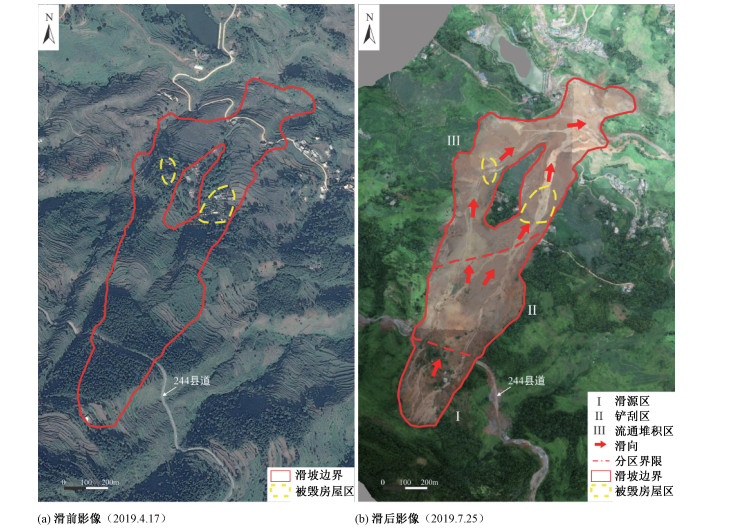
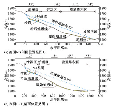
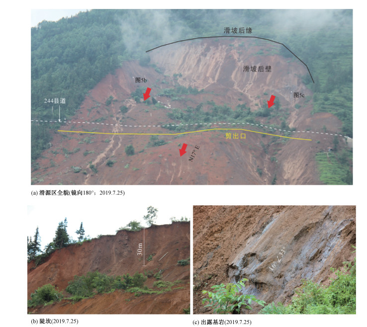
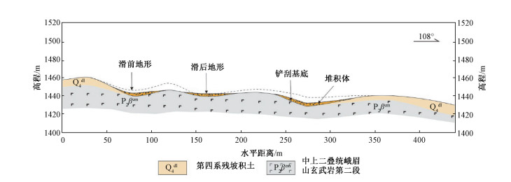
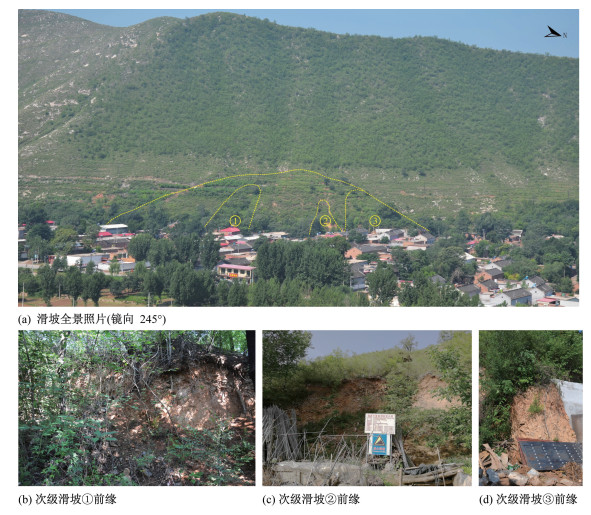
2020 Vol. 26, No. 4

Display Method:
Inside Cover
2020, 26(4): 封二-封三.
Abstract (122) PDF (19787KB)(21)
Abstract:
Chief Editor’s Address
2020, 26(4): .
Abstract (105) HTML (72) PDF (539KB)(22)
Abstract:
Cover Page
2020, 26(4): .
Abstract (88) PDF (1484KB)(16)
Abstract:
Contents
2020, 26(4): .
Abstract (124) PDF (418KB)(16)
Abstract:
Study on the mechanism of deep and large fracture propagation and transfixion in karst slope under the action of mining
YANG Zhongping, JIANG Yuanwen, LI Bin, GAO Yang, LIU Xinrong, ZHAO Yalong
2020, 26(4): 459-470. doi: 10.12090/j.issn.1006-6616.2020.26.04.039
Abstract (710) HTML (97) PDF (24875KB)(33)
Abstract:
In order to study the failure mechanism of the high and steep karst slope under the action of mining,the development law of the slope fracture under the action of mining is studied by using the numerical simulation of universal distinct element code (UDEC). The results show that the mining action has an important influence on the stability of karst slope,which is mainly manifested in the development of new fissures in the overlying rock mass of the coal seam and the expansion and connection of the original fissures in the slope body; the development of the internal fissures in the slope body has a certain time-space effect,and the height of the fracture zone increases with the extension of the mined-out area; the original deep fissures in the slope body have certain damage on the slope body. Under the control action,when the slope is damaged,the landslide body will slide along the main control fracture; under the two-dimensional condition,the karst slope body with deep and large fracture will form a similar "cantilever beam structure" under the action of mining,the cantilever beam structure will break along the main control fracture,the soft rock in the middle of the slope body will be extruded,and finally the main fracture and the free face will expand and connect,and the slope body will collapse.
An analysis of dynamic response characteristics of the Yigong Landslide in Tibet under strong earthquake
LIU Zheng, LI Bin, HE Kai, GAO Yang, WANG Wenpei
2020, 26(4): 471-480. doi: 10.12090/j.issn.1006-6616.2020.26.04.040
Abstract (406) HTML (81) PDF (12311KB)(33)
Abstract:
The Yarlung Zangbo River Grand Canyon area in Tibet is a highly prone area for earthquake-triggered landslides,where several landslides have occurred before. Taking the Yigong Landslide as an example,this article analyzes the frequency response characteristics of the Yigong Mountain by using the FLAC3D finite difference method. Based on the results,the amplification effect of the Yigong Mountain under seismic waves is discussed and the stability of the Yigong Landslide remnant under the condition of near-field strong earthquakes is predicted. Results show that the overall predominant frequency of the Yigong Mountain is at a low value. The predominant frequencies of the mountain top mainly concentrate below 1 Hz,while that of both sides of the mountain top vary from 2~6 Hz. Under the action of seismic waves,the predominant frequencies of the top and both sides of the mountain appear different degrees of amplification,and that in the mountain interior along the height upward shows the change of first increasing then decreasing,and then increasing again. The calculated results are basically identical with the frequency analysis. Stability analysis shows that the Yigong Landslide remnant keeps stable with a safety factor of 1.27 in static condition; however,the results under the earthquake show the occurrence of instability and failure. Finally,it is predicted that the damage of the Yigong Landslide remnant will obviously increase when considering both horizontal and vertical seismic waves. Therefore,it is necessary to strengthen the risk analysis and prediction of mountains under the condition of near-field strong earthquakes.
Study on instability mechanism of shallow landslide caused by typhoon and heavy rain
YAN Jinkai, HUANG Junbao, LI Hailong, CHEN Liang, ZHANG Yanling
2020, 26(4): 481-491. doi: 10.12090/j.issn.1006-6616.2020.26.04.041
Abstract (452) HTML (64) PDF (18167KB)(49)
Abstract:
The instability mechanism of shallow landslide under the coupling of typhoon and heavy rain is studied. On the basis of summarizing the disaster characteristics of landslides caused by typhoon and heavy rain in Fujian, it is proposed that the influence mechanism of wind load on slope deformation and instability is that the slope body is cracked by vegetation, which affects the slope infiltration law. GeoStudio software was used to calculate the changes of transient unsaturated seepage field in the cracked slope body under the condition of typhoon storm infiltration, and to study the effect on the slope stability. The calculation results show that, due to the formation of concentrated infiltration points at the cracks, the infiltration rate of rainwater is greater than that of the unslitted slopes, and the time required for the slopes to reach saturation is greatly shortened. The depth and spacing of cracks have a greater impact on the stability coefficient of landslides. The greater the depth of cracks and the smaller the spacing, the smaller the stability coefficient of the landslide under the same rainfall conditions, and the shorter the rainfall duration required for landslide instability. The effect of crack width on landslide stability is relatively small.
Two-phase motion analysis system for landslide-induced impulse wave based on the particle image velocimetry
CHEN Xiaoting, HUANG Bolin, WANG Jian, ZHANG Quan, FENG Wanli
2020, 26(4): 492-499. doi: 10.12090/j.issn.1006-6616.2020.26.04.042
Abstract (274) HTML (115) PDF (9773KB)(14)
Abstract:
Landslide-induced impulse wave disasters threaten the safety of production and life of residents along both sides of the river and the safety of navigation channels. However, there is still a lack of relevant physical experimental analysis system to provide fluid-solid two-phase motion vector synchronously to deeply analyze the mechanism of impulse wave generated by landslide. In this paper, the particle image velocimetry (PIV) and experimental implementation method based on fluid-solid two-phase recognition are proposed. This PIV technique can achieve a minimum spatial resolution of 1.17 mm and a minimum observation speed of 0.117 m/s in 0.01 s with a 2560×1024-pixel industrial camera under a 3 m×1.5 m observation window. The error sources related to this system and the solutions to overcome the related problems are proposed. A two-phase motion observation platform for landslide and its impulse wave is constructed by related hardware facilities, and a special resolving software is compiled. The demonstration tests of three-dimensional granular pillar collapse, two-dimensional granular column collapse and its impulse wave and underwater collapse-induced impulse wave have been carried out, and good results have been achieved. This system can reveal the whole process of rock, soil and water movement, and has good application prospects. It will provide a powerful research tool for landslide-induced impulse wave and related dynamics research.
Physical experiment and numerical model analysis of surge caused by collapse of columnar dangerous rock mass
ZHAO Hailin, HUANG Bolin, ZHANG Quan, ZHENG Jiahao, FENG Wanli, CHEN Xiaoting
2020, 26(4): 500-509. doi: 10.12090/j.issn.1006-6616.2020.26.04.043
Abstract (395) HTML (64) PDF (8422KB)(19)
Abstract:
Columnar dangerous rock mass is a common hidden geological hazard in the Three Gorges reservoir area, and the surge induced by collapse causes great threat and damage to shipping, tourism, production and life, as well as personnel and property in the reservoir area. In this paper, based on the boundary conditions of the formation and movement of the columnar dangerous rock mass in the field, the physical experiment and numerical simulation of surge caused by the collapse of granular columns are carried out. The results show that the numerical model can well simulate the formation process, vector information and interaction with water, and the velocity curve shows the energy transfer quantitatively. The deviation of surge height between the physical test and the numerical simulation is about 3~4 cm; the stacking angle of the numerical simulation stacking area is 5% larger than that of the physical experiment; the moving distance of the leading edge is 7% smaller. It provides an important basis for prediction and early warning of surge disaster caused by the collapse of columnar dangerous rock mass.
Progress and issues in the research of impact and scraping effect of high-elevation and long-runout landslide
GAO Yang, LI Bin, GAO Haoyuan, HE Kai, LIU Pengfei
2020, 26(4): 510-519. doi: 10.12090/j.issn.1006-6616.2020.26.04.044
Abstract (405) HTML (77) PDF (9040KB)(41)
Abstract:
The impact and scraping effect has always been a hot issue in the dynamics study of high-elevation rock landslide in the southwestern mountainous area of China. On the basis of a large number of field investigations and the current research status at home and abroad, the current basic theory and research methods are summarized. Starting with the typical cases at home and abroad, it is concluded that the impact and scraping modes of high-elevation and long-runout landslides mainly include the embedded shovel-up mode, entrainment mode, impact-slipping mode and impact-splash mode. The difficulties and key issues in the research are put forward. In the aspects of theoretical analysis, numerical calculation, artificial intelligence and risk prediction, future research ideas are prospected. It is aimed to provide an important research basis for the analysis of the disaster pattern and dynamic characteristics of high-elevation landslide under the impact and scraping effect, and to provide technical support for the dynamic research of high-elevation and long-runout landslide, scientific disaster prevention and reduction and scientific rescue work.
Analysis of the fluidization process of the high-position and long-runout landslide in Shuicheng, Liupanshui, Guizhou Province
LI Zhuang, GAO Yang, HE Kai, GAO Haoyuan, WEI Tongyao, LIU Zheng, ZHAO Zhinan
2020, 26(4): 520-532. doi: 10.12090/j.issn.1006-6616.2020.26.04.045
Abstract (556) HTML (121) PDF (37221KB)(37)
Abstract:
High-position and long-runout landslide is a kind of common geological disaster in the southwestern mountainous area of China. It always exists with impact disintegration effect,then converts to avalanche debris or debris flow with the characteristics of fluidization movement and accumulation. The Jichang landslide,occurred in Shuicheng County,Liupanshui City,Guizhou Province,China on July 23,2019, is a typical high-position and long-runout fluidized landslide. The position difference between toe and crown is 430 m,the horizontal movement distance is 1340 m,and the volume of accumulation body is 200×104 m3,which caused 21 houses being buried and 51 people being killed. Based on the detailed field investigation and the comparison of the topography before and after the landslide,the whole process of the movement and accumulation of the landslide is simulated and analyzed by using DAN-W. (1) The maximum thickness of the accumulation body in the source area and accumulation area of the Shuicheng landslide is 27 m and 15 m respectively,the maximum velocity is 27 m/s in the front of debris flow,and the maximum kinetic energy is 6.57×10⁶ J. (2) Due to the conversion of potential energy into kinetic energy,the landslide quickly reaches the peak velocity and scrapes the loose soil layer on the surface. (3) Due to heavy rainfall,the main body moves at high speed so that the pore water of the basement can't be discharged in time,which leads to the decrease of the friction of the basement and reduces the energy loss; Disintegration of the main body promotes fluidization of particles,then reduces friction,which is also an important reason for the long-runout movement of landslide.
Study on the surge induced by the collapse of dangerous rock mass in Longmen Village in Three Gorges reservoir area
ZHENG Jiahao, HUANG Bolin, ZHANG Quan, ZHAO Hailin, FENG Wanli, WANG Jian, CHEN Xiaoting
2020, 26(4): 533-543. doi: 10.12090/j.issn.1006-6616.2020.26.04.046
Abstract (392) HTML (109) PDF (18089KB)(20)
Abstract:
The towering rock masses on both sides of the Yangtze River bring huge safety hazards to the waterway and residents along the river. The Daning River is a tributary of the Yangtze River. The dangerous rock mass in Longmen Village is located above the Daning River, only 1km away from Wushan County. In this paper, the FLOW-3D software model is used to simulate the generation and propagation processes of the surge induced by the collapse of the dangerous rock mass in Longmen Village under two water level conditions of 145 m and 175 m. The numerical simulation analysis shows that the maximum surge height at 145 m and 175 m water level is about 17.8 m and 11.6 m respectively. At the five wharfs in Wushan County, the maximum surge climbs as high as 6.4m and 2.1 m respectively under the two water level conditions. According to the surge height, the Daning River area is zoned based on the risk level. When the water level is 145 m high, the extremely high-risk zone is about 4.4 km and the very high-risk zone is about 1.9 km; when the water level is 175 m high, the extremely high-risk zone is about 3.0 km and the very high-risk zone is about 1 km. The potential surge hazard of the dangerous rock mass in Longmen Village endangers the safety of the Daning River waterway and the wharfs in Wushan county. This study provides a basis for the early warning of landslide-induced surge disasters in the Three Gorges reservoir area.
Fundamental problems and prospects in the study of deposition dynamics of viscous debris flow in the gully-river junction
LIU Jingjing, MA Chun, LI Chunyu
2020, 26(4): 544-555. doi: 10.12090/j.issn.1006-6616.2020.26.04.047
Abstract (367) HTML (62) PDF (8357KB)(19)
Abstract:
Viscous debris-flow deposits in the junction with mainstream channel may greatly change the morphology, and the dynamics relies on the interaction between the Newtonian fluid and non-Newtonian fluid. The deposition under water differs much from that on the surface, and properly describing the subaqueous process is significant for zoning the danger area and understanding the river evolution. This review provides a comprehensive survey of studies on subaqueous deposition of debris flows and puts forward some questions for the future. We found several new phenomena during the deposition under water, such as the intermittent transport, the "unitary" deposit due to separate surges, and the "water slip" of the surge front, which have been long ignored in previous studies. The existing studies are all based on oversimplification of the water-flow interaction, which considers debris flow as sediment-load flow and adopts the method of density flow, or treats debris flow as a semi-solid state and takes into account only the sediment transport by water flow. Such paradigms do not match the complexity of the real processes and usually underestimate the deposition scale. Then we suggest that further studies, based on the special phenomena, should be emphasized on 1) finding a new framework of the water-flow interaction in the junction, and 2) establishing a new model for debris-flow deposition under water.
Geohazard monitoring and risk management of high-steep slope in the Wudongde dam area
LI Bin, ZHANG Qing, WANG Wenpei, ZHAO Qisu, WANG Chenhui, HE Kai, GAO Yang, ZHANG Xiaofei
2020, 26(4): 556-564. doi: 10.12090/j.issn.1006-6616.2020.26.04.048
Abstract (581) HTML (137) PDF (14781KB)(52)
Abstract:
Taking the high-steep slope of Shuidiantang of the Wudongde dam on the Jinsha River as an example, this paper explores systematically the early warning technology and risk management of the high-steep slope monitoring with a height of over 500 m. Rock mass collapse often occurs at slopes with the gradient greater than 70°, and it is difficult to identify. With the method of rock climbing technique, geological survey and geological mapping, the high precision identification and analysis of the dangerous rock mass is achieved. Totally, 178 dangerous rocks are identified. On the basis of this result, the distributed optical fiber strain monitoring and the pull-line displacement sensor of the fractured rock are distributed to monitor in real-time the deformation of the rock mass. The monitoring data are in agreement with the reality. Furthermore, six seismic monitoring stations were set up between the slope of the elevation of 580~1600 m. Many seismic acceleration data were caught, including that of the Wudongde earthquake on December 8, 2016 and the Ludian earthquake on March 12, 2017. On the basis of these data, the stability and dynamic response of the Wudongde earthquake on this high-steep slope are analyzed. The results show that this slope is in the basically stable state. The ideas and methods of high-steep slope warning and risk assessment of southwest hydropower stations are of reference significance.
InSAR monitoring and analysis of landslide deformation after the earthquake in the Zhangmu Port, Tibet
HAN Dongjian, YANG Chengsheng, DONG Jihong
2020, 26(4): 565-574. doi: 10.12090/j.issn.1006-6616.2020.26.04.049
Abstract (407) HTML (76) PDF (21685KB)(17)
Abstract:
The Zhangmu Port,located on the border between China and Nepal,is a national first-class land trading port and the largest border trade port in Tibet. After the Nepal earthquake in 2015, the Zhangmu port was closed due to multiple landslide disasters. In order to investigate the distribution and deformation of landslide disasters in the Zhangmu port area so as to serve regional disaster mitigation and prevention,the InSAR technology was used to process the satellite image data of Sentinel-1A and ALOS-2 covering the area,and by analyzing the annual average rate map of line-of-sight deformation,17 suspected landslides were delineated,and the time series deformation characteristics of 5 typical landslides were analyzed. From the distribution point of view,the landslides identified by monitoring are basically distributed along the left bank of the Boiqu River on the side of National Highway 318. InSAR survey results show that the landslides in the Zhangmu area affected by the earthquake are mostly distributed on the steep hills along the left bank of the Boiqu River. The ancient landslides on the section of Disigang to Youyi Bridge on the China-Nepal Highway have partially resurrected,and the Zhameila dangerous rock mass collapses and landslides are also developed in the urban area where residents live in Zhangmu Town.
Research on multi-source heterogeneous data fusion algorithm of landslide monitoring based on BP neural network
WANG Zhiwei, WANG Li, HUANG Guanwen, HAN Qingqing, XU Fu, YUE Cong
2020, 26(4): 575-582. doi: 10.12090/j.issn.1006-6616.2020.26.04.050
Abstract (461) HTML (126) PDF (4701KB)(35)
Abstract:
Aiming at the multi-source heterogeneous data fusion problem of landslide monitoring,a multi-source heterogeneous monitoring data fusion algorithm based on BP neural network is proposed in this paper. The temperature,humidity,wind power,cloudiness,precipitation and accumulated precipitation which affect the landslide deformation are taken as the input variables,and the landslide displacement changes data are taken as the expected output data in this algorithm. And the prediction accuracy of this algorithm can be effectively improved by filtering the environmental factor variables with calculating the correlation and significance of the environmental factor variables and the landslide displacement changes. This algorithm is verified by the monitoring data of the Dangchuan landslide in Heifangtai,Yongjing County,Gansu Province. The results show that the BP neural network data fusion algorithm can be used in the landslide displacement prediction with multi-source heterogeneous monitoring data. After the environmental factor variable filtering,the determination coefficient of the BP neural network data fusion algorithm can achieve 0.985 and the RMSE can achieve 0.4787 mm. Thus the accuracy of deformation prediction can be effectively improved.
In-situ stress measurement in the shallow basement of the Shanghai area and its structural geological significance
ZHANG Hao, SHI Gang, WU Hong, SHAO Lei, WANG Qian
2020, 26(4): 583-594. doi: 10.12090/j.issn.1006-6616.2020.26.04.051
Abstract (421) HTML (90) PDF (20688KB)(44)
Abstract:
By the hydraulic fracturing method and the ultrasonic imaging logging method, in-situ stress measurement was carried out in the shallow basement (180 m depth range) of the Shanghai area. The measurement results show that the maximum horizontal principal stress is between 9.54~12.91 MPa, and the minimum principal stress is between 5.41~6.96 MPa. The maximum horizontal principal stress direction is NW42°-62°, the dominant orientation is NW, and the stress structure is SH > Sh > Sv, which reflects the characteristics of the regional structural stress field. Based on the spatial distribution of the internal fractures in the area and the in-situ stress measurement results, the NE faults are prone to compressive or compression-torsional reverse faulting and the faults are relatively stable, while the NW faults are prone to tensile or tension-torsional positive faulting, which is still worthy of attention under the current relatively high stress level. At the same time, the in-situ stress measurement results may have guiding significance for the study of the structural boundary trend (the Jiangshan-Shaoxing fault) in this area.
Analysis of the stability of the Lisizhuang landslide in Shunping County, Hebei Province
WANG Huiqing, FENG Chengjun, QI Bangshen, WANG Jiming, SUN Mingqian, YANG Xiaoxiao, WAN Jiawei, FAN Yulu, ZHANG Peng, MENG Jing, TAN Chengxuan
2020, 26(4): 595-603. doi: 10.12090/j.issn.1006-6616.2020.26.04.052
Abstract (341) HTML (235) PDF (13404KB)(22)
Abstract:
The Lisizhuang landslide is the most potentially dangerous accumulation landslide in a residual slope accumulation layer. The toe of the landslide slope was cut to meet the need of construction land, reducing the stability of the landslide. Under the extreme rainfall conditions, the landslide may revive. Based on the field survey, the structural characteristics and main factors affecting the stability of the Lisizhuang landslide are determined. An improved Mein-Larson rainfall infiltration model was utilized to analyze the influence of different rainfall intensities and durations on the safety factor of the landslide. And the finite difference software FLAC3D was used to simulate the stability of the landslide under natural conditions and extreme rainfall conditions. The results show that:In the natural state, the potential slip surface of the slope is the interface between the bedrock and the residual slope, and the safety factor is 1.18. The landslide stays stable. With the increase of the rainfall duration, the potential slip surface is transferred from the interface between the bedrock and the residual slope to the wetting front. When the wetting front reaches the boundary between the bedrock and the residual slope, the numerical simulation shows that the safety factor of the landslide is 0.83, and the landslide is unstable. Retaining wall and drainage ditch for slope treatments of the Lisizhuang landslide are put forward in this paper.
Characteristics and susceptibility evaluation of geohazard development in Shunping county, Hebei province
WAN Jiawei, FENG Chengjun, QI Bangshen, SUN Mingqian, YANG Xiaoxiao, WANG Huiqing, FAN Yulu, ZHANG Peng, MENG Jing, TAN Chengxuan
2020, 26(4): 604-614. doi: 10.12090/j.issn.1006-6616.2020.26.04.053
Abstract (727) HTML (219) PDF (21688KB)(43)
Abstract:
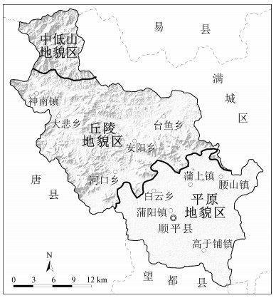
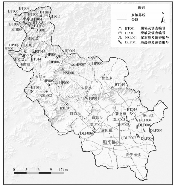
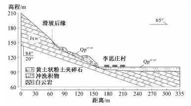
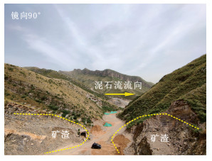
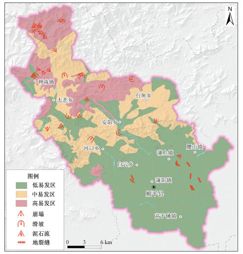
Shunping county of Hebei province is located at the eastern foot of the Taihang Mountains. There mainly are four kinds of geohazards, including rockfall, landslide, mud-rock flow, and earth fissures, which are widely distributed in different geomorphic units of this county. Based on the analysis of geohazard development characteristics, this paper selects six factors, namely slope angle, level difference, slope direction, engineering geological rock group, normalized differential vegetation index (NDVI), and distance to rivers, to evaluate the susceptibility of geohazards in Shunping county, by the GIS technology and Information Value method. The results show that:(1) The areas with high susceptibility, where rockfalls occur frequently and landslides and mud-rock flows occur in less often, are scattered on the medium-low mountains and hills in the northwestern Shunping with the area about 125 km2, accounting for 17.5% of the total area of this county; (2) The areas with medium susceptibility, where rockfalls, landslides and mud-rock flows occur occasionally, are widely distributed on the medium-low mountains and hills in the northwestern Shunping with the area about 200 km2, accounting for 28.0% of the total county area; (3) The areas with low susceptibility, where earth fissures occur occasionally and rockfalls, landslides and mud-rock flows occur rarely, are mainly distributed on the plains in the southeastern Shunping and the wide gullies between the hills in the northwest, with the area about 389 km2, accounting for 54.5% of the total county area.