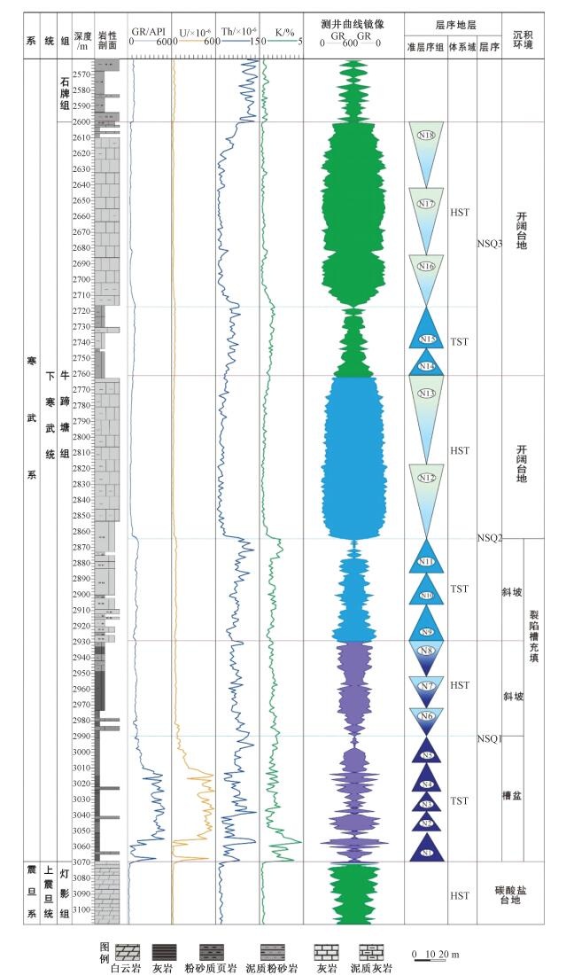
2020 Vol. 26, No. 5

Display Method:
Cover Page
2020, 26(5): .
Abstract (88) PDF (1454KB)(23)
Abstract:
Inside Cover
2020, 26(5): 封三-封三.
Abstract (111) HTML (69) PDF (19474KB)(17)
Abstract:
Contents
2020, 26(5): .
Abstract (85) PDF (319KB)(21)
Abstract:
Chief Editor’s Address
2020, 26(5): .
Abstract (108) HTML (63) PDF (629KB)(16)
Abstract:
Inside Cover
2020, 26(5): 封二-封二.
Abstract (104) HTML (52) PDF (8438KB)(17)
Abstract:
Composite structure and growth of the Longmenshan foreland thrust belt in the eastern margin of the Qinghai-Tibet Plateau
YAN Danping, SUN Ming, GONG Lingxiao, ZHOU Meifu, QIU Liang, LI Shubing, ZHANG Sen, GU Shuhang, MU Hongxu
2020, 26(5): 615-633. doi: 10.12090/j.issn.1006-6616.2020.26.05.054
Abstract (372) HTML (142) PDF (46747KB)(52)
Abstract:
It has been proved that the NE-trending Longmenshan thrust belt in the eastern margin of the Qinghai-Tibet Plateau was a composite of the expansion and growth of the Mesozoic and Cenozoic foreland thrust belts. However, puzzle is remained for the unidirectional and segmented migration of earth surface failures, aftershocks, and landslides of the Wenchuan earthquake on May 12, 2008. This puzzle challenges the understanding for the texture of the Longmenshan composite thrust belt. Based on the previous studies, this paper applied geological investigation and structural analysis focusing on a possible special texture produced by the composite growth of the Longmenshan thrust belt. The results reveal a composite texture produced by the growth of the Cenozoic foreland thrust belt superimposed over the Mesozoic foreland thrust belt with foundation of the composite thrust wedge. The composite thrust wedge could be graded with formational sequence. The Mesozoic foreland thrust wedges are characterized by thrust fault-related anticlines. Thrust complexes of Bikou, Tangwangzhai and Longwangmiao, which are combined by foreland thrust wedges, were initiated before the late Triassic (237 Ma) and terminated at ~160 Ma. The Cenozoic foreland thrust wedge is composed of thrust fault and sheet, and was staged produced by SE-ward progressive propagation at about 35~10 Ma and 10 Ma, respectively. This thrust wedge propagation might result in the Longquanshan uplift in the east of the western Sichuan basin. Therefore, the Longmenshan foreland thrust belt has characteristics of composite texture and composite growth.
Tectonic reconstruction of northwest China in the Nanhua-Paleozoic and discussions on key issues
JI Wenhua, LI Rongshe, CHEN Fenning, YANG Bo
2020, 26(5): 634-655. doi: 10.12090/j.issn.1006-6616.2020.26.05.055
Abstract (414) HTML (188) PDF (17284KB)(49)
Abstract:
The Paleo-Asian and Paleo-Tethyan tectonic collages in northwest China experienced a complex ocean-continent evolution from the Nanhua period to Paleozoic era, and the continent-continent collisions in Triassic formed the basement to the formation of the intracontinental basin and mountain since the Mesozoic. There are still controversies on the closure and location of the Paleo-Asian oceanic basin and tectonic attribution of the Paleozoic Qin-Qi-Kun orogenic belt. Based on the new geological mapping, and analyses of sedimentary formations, magmatism formations, metamorphism and structural deformations, the Nanhua to Paleozoic tectonic units of northwest China are composed of three oceanic plates, four arc-basin systems and two continental blocks, which can be subdivided into 9 second-order, 46 third-order and 112 forth-order tectonic units. These units could be used to depict the residual compositions of disappeared oceanic basins and marginal accretionary structures of the blocks (lands). Integrated with paleomagnetic and bio-paleogeographical data, we propose the Paleozoic paleogeography reconstructions of northwest China, and discuss the tectonic evolutionary process of oceanic subduction and continental assemblages.
Multistage evolution of mantle plume and the ore-forming and ore-controlling role of mantle branch structure: A study on mineralization of the Guojiadian mantle branch structure in northwestern Jiaodong
NIU Shuyin, SUN Aiqun, CHEN Chao, ZHANG Fuxiang, ZHANG Jianzhen, WANG Fengxiang
2020, 26(5): 656-672. doi: 10.12090/j.issn.1006-6616.2020.26.05.056
Abstract (238) HTML (61) PDF (21882KB)(28)
Abstract:
This paper briefly introduces the establishment of metallogenic theory of mantle branch structure, the characteristics, unit division and fault structure system of mantle branch structure, as well as its mineralization. During the late Yanshanian movement, the eastern part of North China entered the evolutionary stage of mantle plume dominated by extensional structures. The Laiyang mantle sub plume and its surrounding mantle branch structures, such as Guojiadian, Qipeng and Mouru, were formed in northwestern Jiaodong. The Guojiadian mantle branch structure was strongly active in the late Yanshanian, which generally formed the Jiaojia fault as a main detachment zone in the hanging wall and the Sanshandao fault as a reverse shovel fault intersecting with the Jiaojia fault, and controlled the formation of a series of large and super large deposits such as the Linglong, Jiaojia and Sanshandao gold deposits. Among many ore-forming and controlling factors, regional fault structure should be an important dominant factor, which not only provides channels for the migration of ore-forming fluids, but also provides favorable spaces for the precipitation of ore-forming materials. The deep source ore-bearing fluids are concentrated and mineralized through mantle plume, sub-mantle plume, mantle branch structure, favorable structural expansion zones successively, i.e.brittle ductile-brittle shear zone, internal and external contact zone of intrusive rock mass, dense structural fracture zone, contact zone between vein rock and surrounding rock. In recent years, deep geological exploration in northwestern Jiaodong has found that several large and medium-sized gold deposits in the shallow distributed along the regional fault might be integrated in a certain depth and often became a super large gold deposit.
Basic characteristics, dynamic mechanism and development direction of the formation and distribution of deep and ultra-deep carbonate reservoirs in China
PANG Xiongqi, LIN Huixi, ZHENG Dingye, LI Huili, ZOU Huayao, PANG Hong, HU Tao, GUO Fangxin, LI Hongyu
2020, 26(5): 673-695. doi: 10.12090/j.issn.1006-6616.2020.26.05.057
Abstract (1091) HTML (106) PDF (35380KB)(128)
Abstract:
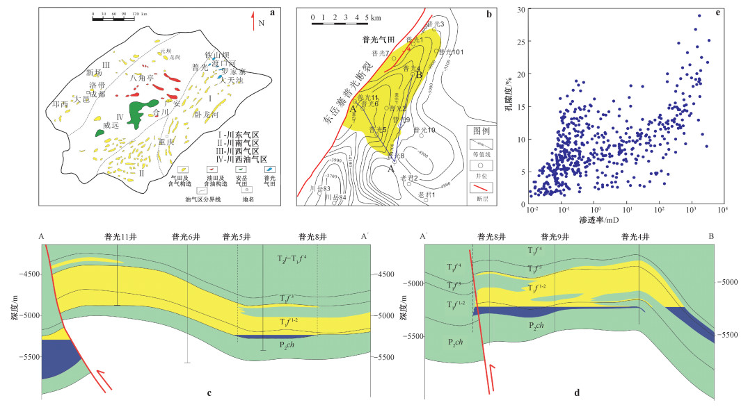
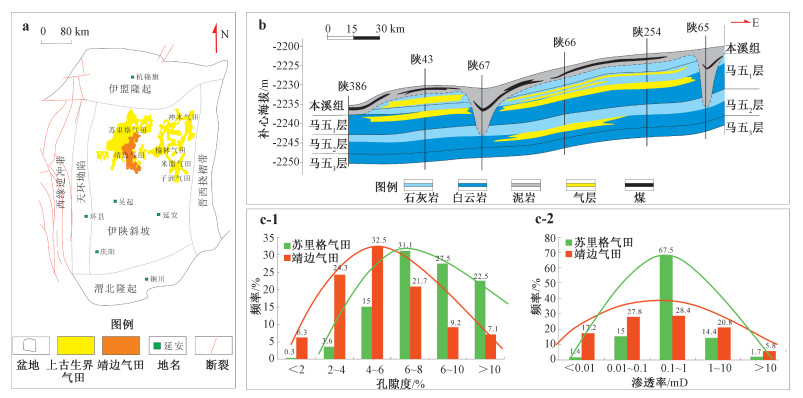
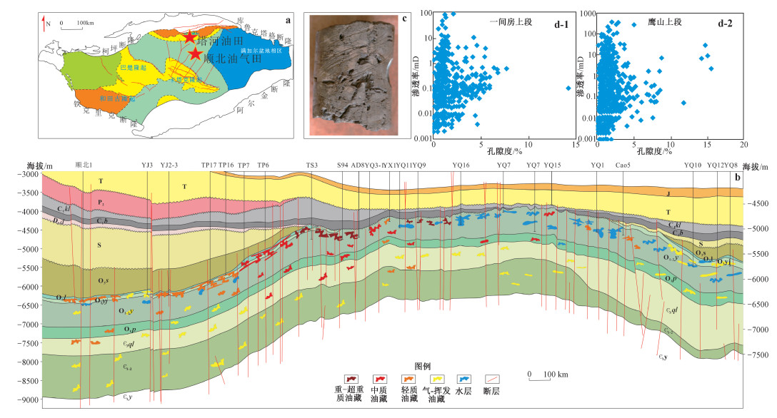
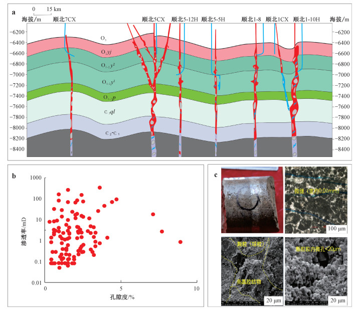
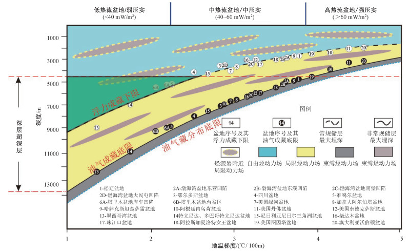
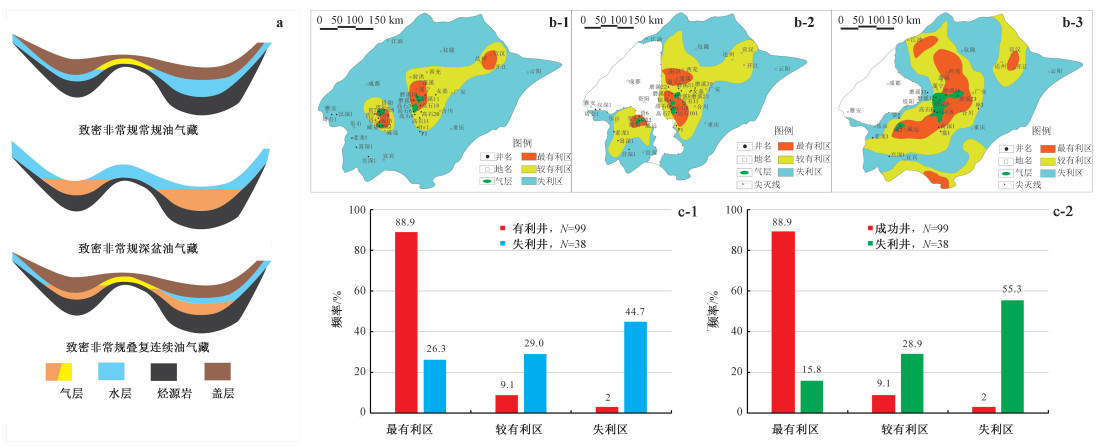
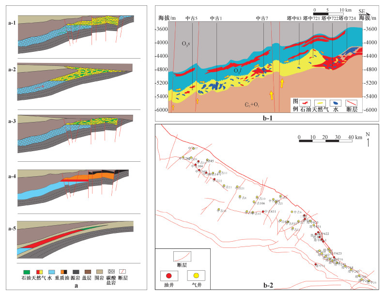
With the increasing dependence on external oil and gas resources, China's oil and gas exploration has expanded to deep and ultra-deep areas and discovered a number of large oil and gas fields in the central and western basins successively, such as the Tahe, Puguang, Anyue, Jingbian and Shunbei oilfields, showing a broad prospect of exploration. The proven deep and ultra-deep carbonate reservoirs in China are quite different from those in the world, and the exploration of these oil and gas fields under the guidance of the classical oil and gas geological theories has met unprecedented challenges, which need to be improved and developed. Through the investigation and comparison of the geological characteristics of the proven carbonate and sandstone reservoirs around the world, it is found that their oil and gas source conditions, accumulation dynamics, and evolution processes are similar; however, it is revealed at the same time that the mineral composition of reservoir layers, their porosity and permeability change characteristics with buried depth, porosity and permeability structure characteristics, the lower limit of reservoir physical properties, and oil and gas reservoir types are very different. There are five differences between the deep and ultra-deep carbonate reservoirs in China and other basins in the world, which in China have older formations, greater burial depth, greater dolomite reservoir ratio, higher natural gas resource ratio, and more chaotic relationship between porosity and permeability. The genetic types of deep carbonate reservoirs discovered in China can be classified into five types: sedimentary high-porosity and high-permeability oil/gas reservoirs, compacted diagenetic low-porosity and low-permeability oil/gas reservoirs, crystalline diagenetic low-porosity and low-permeability oil/gas reservoirs, fluid modified high-porosity and low-permeability oil/gas reservoirs, and stress reformed low-porosity and high-permeability oil/gas reservoirs. The dynamic mechanisms of their formation are respectively related to the oil and gas migration dominated by stratigraphic deposition and buoyancy, formation compaction and non-buoyancy, diagenetic crystallization and non-buoyancy, fluid reformed media and buoyancy, stress reformed media and buoyancy. There are mainly three favorable areas and related types of oil and gas reservoirs for the exploration and development of China's deep and ultra-deep carbonate reservoirs. The first is the conventional oil and gas reservoirs with high-porosity and high-permeability, formed in the free oil/gas dynamic field above the hydrocarbon buoyance-driven depth limit in basins with low heat flow. The second is the fracture-cavity compound oil/gas reservoirs, formed by external stress and inner fluids activities in the superimposed basin due to frequent structural changes. The third one is the extensive compacted continuous unconventional tight oil/gas reservoirs, formed by the confined dynamic field in the structurally stable basin. The reformed unconventional tight carbonate oil and gas reservoirs are the main types of future oil and gas resources in the deep and ultra-deep layers of China's petroliferous basins. They both have the characteristics of conventional reservoirs formed in the early stage and their own unconventional characteristics of extensive and continuous distribution, and have undergone structural changes in the later stage. The complex distribution characteristics, dense medium conditions and high temperature and pressure environment make the exploration and development of this kind of oil and gas resources difficult and costly.
Accumulation model of the Sinian-Cambrian shale gas in western Hubei Province, China
ZHAI Gangyi, WANG Yufang, LIU Guoheng, LU Yongchao, HE Sheng, ZHOU Zhi, LI Juan, ZHANG Yunxiao
2020, 26(5): 696-713. doi: 10.12090/j.issn.1006-6616.2020.26.05.058
Abstract (342) HTML (205) PDF (28612KB)(37)
Abstract:
Based on the study of a large number of real data of shale gas exploration in the Sinian Doushantuo Formation and the Cambrian Niutitang Formation in western Hubei Province, the theoretical understanding of shale gas accumulation in the Sinian and Cambrian that lithofacies controls carbon, diagenesis controls hydrocarbon and structure controls reservoir is put forward innovatively. The deposition of organic-rich shales in the Sinian Doushantuo Formation and the Cambrian Niutitang Formation were controlled by the rift trough in western Hubei. Sweet spots of organic-rich shales were mainly formed in the transgressive system tract and the early high water-level system tract. The long-term shallow burial in the Sinian and Triassic around the Huangling paleo-uplift provided sufficient time for the oil generation. The Triassic is a short-term and rapid burial period, which is the main peak period of shale gas generation. The rigid basement of paleo-uplift, regional shale cap rock and later thrust nappe structure provided good conditions for the shale gas preservation. Thus, the shale gas accumulation model of the Sinian and Cambrian in western Hubei Province is established, which includes carbon control by deep-water trough, hydrocarbon control by shallow burial of paleo-uplift, reservoir control by paleo-uplift and thrust fault.
Dynamic formation mechanism of landslide disaster on the Loess Plateau
PENG Jianbing, WANG Qiyao, ZHUANG Jianqi, LENG Yanqiu, FAN Zhongjie, WANG Shaokai
2020, 26(5): 714-730. doi: 10.12090/j.issn.1006-6616.2020.26.05.059
Abstract (1098) HTML (167) PDF (36991KB)(125)
Abstract:
Landslide disaster is a major geological problem that threatens the safety of people's life and property, and the construction and operation of towns and major projects on the Loess Plateau. Aiming at the dynamic formation mechanism of landslide on the Loess Plateau, based on a large number of investigation, statistics, tests and theoretical analysis, following conclusions were drawn: The regional tectonic stress is the main driving force for high occurrence of landslides. It is the controlling factor for landslides ocurring in different zones and belts and the first internal cause. The tectonic stress of the slope not only creates the structural surface, but also continuously alters and loosens the structural surface and dismembers the integrity of the slope. It is the main driving force for the formation of single landslide and the second internal cause of loess landslide. Loess is a kind of special structural soil with strong water sensitivity, which is prone to disasters under soil stress drive. This disaster-prone property of loess is the internal cause of soil disaster and the third internal cause of loess landslide. A large number of landslides are related to water. Surface water penetrates into the shallow surface of loess in large quantities, which will cause shallow surface collapse and sliding disasters. When water enters the deep loess along the micro, fine and macroscopic dominant channels, it may cause deep-seated landslides. Thus, the seepage of dynamic water is the major external cause of loess landslide. Construction disturbance will not only change the original stress state of slope, but also expand and loosen the existing structural plane. Nowadays, construction disturbance has become an important geological agent to induce geological disasters and is the secondary external cause of loess landslide.
Diamond in oceanic peridotites-chromitites and recycled in deep mantle
YANG Jingsui
2020, 26(5): 731-741. doi: 10.12090/j.issn.1006-6616.2020.26.05.060
Abstract (236) HTML (110) PDF (16796KB)(27)
Abstract:
Microdiamonds have been recovered from mantle rocks and associated podiform chromitites in many ophiolites across the world and, in particular, in-situ diamonds were found in ophiolitic chromitites in Southern Tibet and Northern Ural. Microdiamonds in ophiolites present a new type occurrence of diamonds on Earth, different from those diamonds occurring in kimberlites and ultrahigh pressure metamorphic belts. The discoveries of pressure-sensitive minerals such as coesites with stishovite pseudomorph, high-pressure facies chromitites and Qingsongites (BN) indicate that ophiolitic chromitite may form at depths of >150~300 km or even deeper in the mantle. The very light C isotope composition (δ13C -18‰ to -28‰) of these ophiolitic diamonds, Mn-bearing mineral inclusions observed in these diamonds and coesite occurring in chromite all indicate the recycling of ancient continental or oceanic materials into the deep mantle (>300 km) or down to the mantle transition zone via subduction. These new observations and data strongly suggest that microdiamonds and their host podiform chromitite may have formed near the transition zone in the deep mantle, and that they were then transported upward into shallow mantle depths by convection processes. Thus, a new model has been proposed for deep subduction and recycling of oceanic crust in deep mantle. The discovery of diamonds and other UHP minerals from peridotites and chromitities in ophiolites doubts the current shallow genesis of ophiolitic chromitites and raises a serious of new scientific questions which leads to a new research direction.
Internal and external factors in continental lithosphere mantle replacement in eastern China
ZHENG Jianping
2020, 26(5): 742-758. doi: 10.12090/j.issn.1006-6616.2020.26.05.061
Abstract (336) HTML (107) PDF (17762KB)(47)
Abstract:
Cratonic continent usually has an ancient, thick and refractory lithosphere mantle. Depleted basaltic composition, low density and high rigidity make the cratonic lithosphere float above the asthenosphere enclosure and exist stably for a long time. The eastern China continent was formed through the collision of the North and South China blocks along the Qinling-Dabie-Sulu Orogenic Belt during the Paleozoic and the early Mesozoic, and was reactive in the Phanerozoic, especially in the late Mesozoic. Since then, the eastern China continent showed the charateristics of strong tectonic deformation, basin formation, magmatism and massive mineralization. What are the deep reasons which caused these effects? Based on the analysis of formation and evolution of the eastern continent and the properties of the lithosphere mantle, it can be found that the initial scale of the block was small, and the developed zones were weak and easily affected by later transformation. Especially since the Phanerozoic, the Chinese mainland has been clamped by several surrounding tectonic domains, and the asthenospheric upwellings caused by subductions in different stages and directions have eroded along the weak zones and reformed the overlying lithosphere. These effects led to the thinning lithosphere, significant re-enrichment and ultimate mantle replacement. After the transformation and replacement, the lithosphere mantle that was enriched in basaltic components and had high density and low rigidity, was prone to deformation and partial melting, which made the stable cratonic continent activated. The block scale, internal weak zones and surrounding tectonic environment are, therefore, important internal and external factors in controlling continental stability. The lithospheric evolution of eastern China in the Phanerozoic reflects comprehensive records of these favorable factors.
Petrogenesis and geodynamic implications of Neoproterozoic typical intermediate-felsic magmatism in the western margin of the Yangtze Block, South China
LAI Shaocong, ZHU Yu
2020, 26(5): 759-790. doi: 10.12090/j.issn.1006-6616.2020.26.05.062
Abstract (338) HTML (298) PDF (54799KB)(57)
Abstract:
The South China Block preserves voluminous Neoproterozoic magmatism, it is thus an ideal site for understanding the mantle nature, crustal evolution, and crust-mantle interaction during the assembly and breakup of the Rodinia supercontinent. Although the previous studies have paid more attention to the mafic and felsic rocks, the systematic deep dynamics of intermediate-felsic intrusive rocks is unsubstantial. Based on the recent studies on the Neoproterozoic typical granitoid magmatism, this study provides a systematic insight on the magmatic response of different depth under subduction setting. The new study reveals that the western margin of the Yangtze Block was located at the subduction setting. Apart from the subduction fluids- and slab melts-related mantle metasomatism, the newly recognized ca.850~835 Ma high-Mg# diorites suggest that there existed the subducted sediment melts-related mantle metasomatism. In addition, the identification of ca.840~835 Ma peraluminous granites indicates that the western margin of the Yangtze Block underwent not only the melting of the juvenile mafic lower crust but also the reworking of the mature continental crust during the Neoproterozoic. Moreover, the ca.780 Ma Ⅰ-type granodiorites-granites stand for the magmatic response of different crustal depth induced by the upwelling of asthenosphere mantle. The occurrence from ca.800 Ma thickened lower crust-derived adakitic granites to ca.750 Ma felsic crust-derived A-type granites suggest the geodynamic transition from regionally crustal thickening to extensional thinning under subduction background.
Innovation and application of airborne geophysical exploration technology
XIONG Shengqing
2020, 26(5): 791-818. doi: 10.12090/j.issn.1006-6616.2020.26.05.063
Abstract (420) HTML (429) PDF (31558KB)(87)
Abstract:
This paper briefly reviews the development of China's airborne geophysical exploration technology, focuses on the main technological innovations and application achievements of airborne geophysical exploration in China since the 21st century, especially since the "Eleventh Five-Year Plan", and analyzes and forecasts the future development trend. In order to meet the needs of the state and society, since the "Eleventh Five-Year Plan", China's airborne geophysical exploration technologies, especially the aeromagnetic multi parameter survey, airborne vector magnetic survey, airborne gravity survey and time domain airborne electromagnetic survey, have been developed rapidly. In the process of airborne geophysical exploration technology innovation, the comprehensive research and application of airborne geophysical data have been strengthened. Important achievements have been made in many fields, including geology, solid mineral exploration and energy exploration and evaluation. Airborne geophysical exploration also has shown a good application prospect in groundwater resources survey, engineering geological exploration and environmental geological survey. To meet the demands for national resources and environmental survey, the resolution, stability and practicability of China's airborne geophysical survey system will be further improved in the future. On the basis of strengthening the application in traditional fields such as geology, solid mineral exploration and energy exploration, airborne geophysical exploration will expand and strengthen its application in deep-earth exploration, deep-sea exploration, deep geothermal exploration, water resources investigation, geological disaster investigation, surveying and mapping, military and other fields.