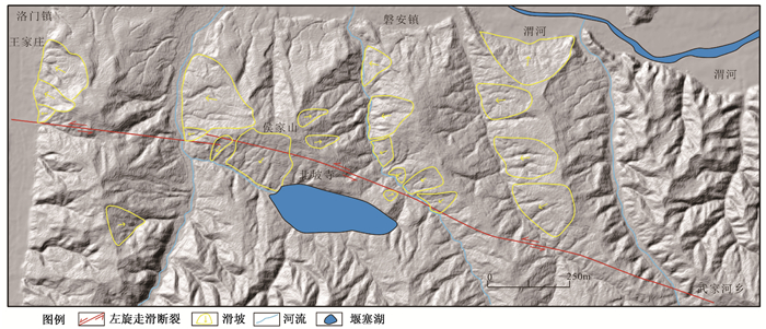
2017 Vol. 23, No. 5

Display Method:
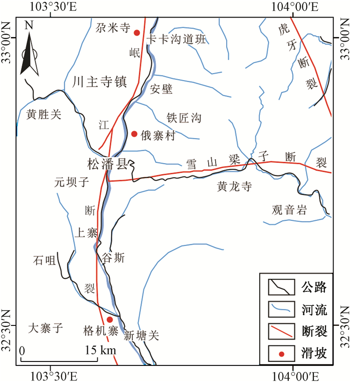
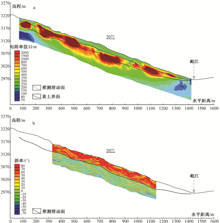
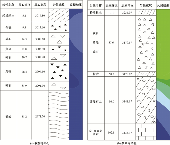
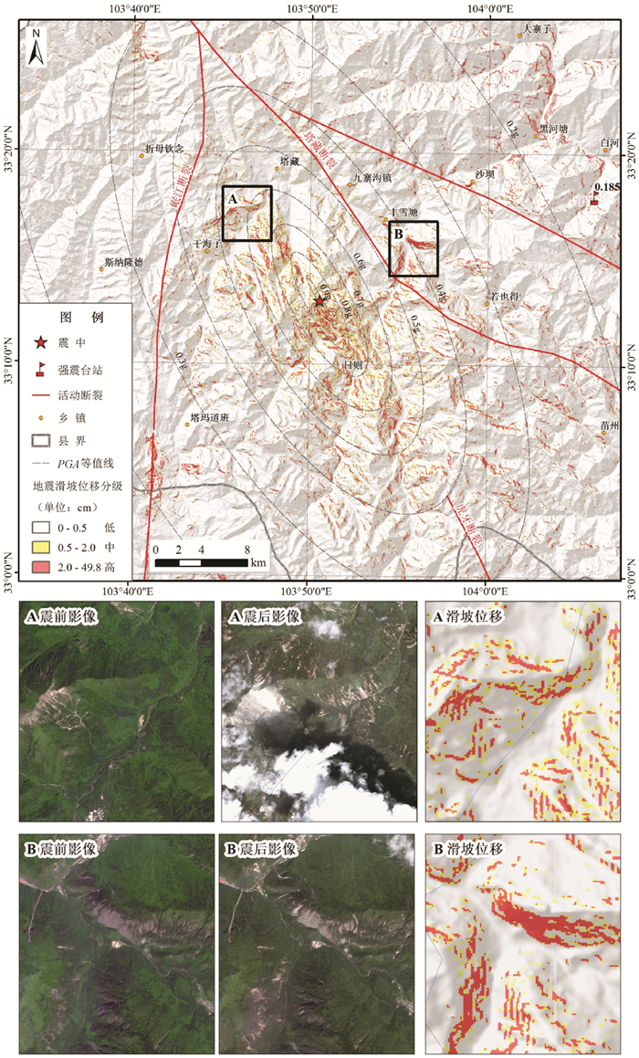
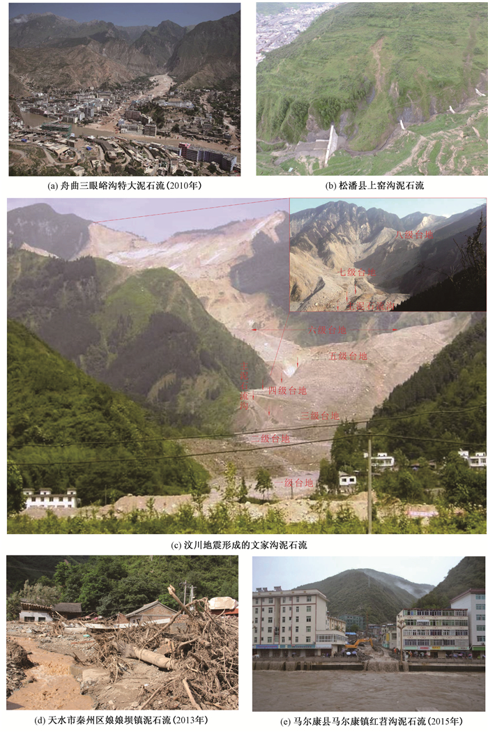
EMERGENCY RAPID ASSESSMENT OF LANDSLIDES INDUCED BY THE JIUZHAIGOU MS 7.0 EARTHQUAKE, SICHUAN, CHINA
LIU Jiamei, WANG Tao, SHI Jusong, LI Zetong
2017, 23(5): 639-645.
Abstract (135) HTML (56) PDF (14414KB)(13)
Abstract:
Based on the Newmark cumulative displacement model, emergency rapid assessment of earthquake landslides induced by the Sichuan Jiuzhaigou Ms 7.0 earthquake was carried out based on regional topographic and geologic data, combined with near-real-time estimates of ground shaking. The analysis results of seismic landslide displacements show that the medium-high risk zones of coseismic landslide activities are mainly concentrated in the area about 4 km width along the seismogenic fault, with a roughly NW-SE rift direction, especially in the Fengxuetang, Rize, and Ganhaizi town of the meizoseismal area. Comparison between the satellite images acquired before and after this earthquake shows that the most common types of landslides induced by the Jiuzhaigou earthquake are shallow debris flows and small scale of rock falls, and the shallow debris flows are mostly formed by the further expansion of activities of the existing landslides. It shows that the obtained displacements can well reflect the macro distribution of coseismic landslide, but they can't be exerted effectively at local site scale, which can be enhanced through the improvement of large scale of geologic maps and high quality topography data. Results can provide valuable timely reference information on the possible societal effects of earthquake-induced landslides.
FRACTURE CHARACTERISTICS OF UPPER PALEOZOIC AND ITS INFLUENCE ON GAS AND WATER DISTRIBUTION ON THE NORTHERN SECTION OF THE TIANHUAN DEPRESSION, ORDOS BASIN
LIU Xinshe, REN Desheng, HOU Yundong, WANG Huaichang
2017, 23(5): 646-653.
Abstract (292) HTML (144) PDF (32880KB)(22)
Abstract:
In connection with types, causes and distributions of the upper Paleozoic fracture in the Tianhuan Depression, Ordos Basin, observations, descriptions and measurements of outcrops, core macroscopic and microscopic microcracks were carried out. Combined with the analysis of logging logs, the results show that tectonic fracture system with different groups, sizes, mechanical properties and structures was developed in the upper Paleozoic strata in the northern part of the Tianhuan Depression, Ordos Basin and it has the control effects on the gas and water distribution. The tectonic fracture system is the main channel for the vertical migration of natural gas in this area. The individual differences of tectonic fractures play a certain role in regulating the distribution of gas and water, which is the main reason for the complicated gas and water distribution in this area.
DYNAMIC RESPONSE ANALYSIS OF THE OBLIQUE METRO TUNNELS IN GROUND FISSURES AREA
LIU Lei, LIU Xueling, MA Tao
2017, 23(5): 654-660.
Abstract (99) HTML (56) PDF (8808KB)(5)
Abstract:
A large scale model test was carried out to study the dynamic response of the oblique metro tunnel in ground fissures area under vibration loads of train. The test results show that subway produces vibration propagation in all directions in the soil with different degree of attenuation while moving, and ground fissures have barrier action on the vibration. The vibration of the ground fissures near the tunnel beneath the soil is larger than that of the upper soil layer, and the vibration response of the arch bottom of the subway tunnel is stronger than that of the hance and the vault. Before ground fissure movements, the additional contact stress is larger between the bottom of the tunnel and the soil; While the declining of the hanging wall of ground fissures, the additional contact stress between the bottom of the footwall tunnel and the top of the hanging wall tunnel near ground fissures and the soil become larger. Before ground fissure movements, the additional strain caused by vibration excitation at both the top and bottom of the tunnel are smaller. While the declining of the hanging wall of ground fissures, the negative additional strain occurs at the top of the hanging wall tunnel and the bottom of the footwall tunnel, while the positive additional strain occurs at the top of footwall tunnel and the bottom of halling wall tunnel. The additional strain becomes larger when the hanging wall declines.
METALLOGENIC AGES AND THE NATURE OF MAGMA SOURCE OF THE YUJIASHAN CU-NI DEPOSIT, HANNAN COMPLEX:CONSTRAINTS FROM ZIRCON U-PB DATING AND LU-HF ISOTOPE
ZHENG Guanggao, CUI Jianjun, LIU Xiaochun, QIAO Jianxin, QU Wei, CHEN Longyao, LI Miao, ZHAO Wenping, LI Dongdong
2017, 23(5): 661-672.
Abstract (210) HTML (124) PDF (6860KB)(12)
Abstract:
The Yujiashan Cu-Ni deposit of Hannan complex is located in the southwest of the Wangjiangshan basic massif, in the west of the northern margin of the Yangtze craton. There is less study on the diagenesis age, mineralization age and the nature of magma source of the outcropped rock mass, which affects the understanding of the deposit genesis. The data of LA-ICP-MS zircon U-Pb dating and in-situ Lu-Hf isotope of the typical outcropped ore-bearing and surrounding rocks were analyzed in the study. The results show that the mineralization age is about or a little late than (791±4) Ma, and the diagenesis age is about (808±6.8) Ma. Furthermore, the in-stiu zircon Hf isotopic analysis indicates that the εHf(t) values of ore-bearing rock range from +9.5~+10.9, with an average value of +10.7 and Hf model ages ranging from 924 Ma to 974 Ma; the εHf(t) values of surrounding rock range from +8.7~+11.1, with an average value of +9.9 and Hf model ages ranging from 924 Ma~974 Ma. Coupled with the available published data, it is proposed that the basic massif of the Yujiashan Cu-Ni deposit maybe derived from the partial melting of depleted mantle materials of late Middle Proterozoic-Neoproterozoic age in the active continental margins setting.
ZIRCON U-PB AGES, GEOCHEMICAL CHARACTERISTICS AND TECTONICS IMPLICATIONS OF LATE JURASSIC INTERMEDIATE INTRUSIVE ROCKS IN SHIQUANHE AREA, WESTERN TIBET
NIMA Ciren, WANG Guocan, DU Dun, PU Chi, Ciren Yangzong, JIAO Wenlong, Li Kaiyun, YE Qiang, LUOSANG Langjie, DA Wa
2017, 23(5): 673-685.
Abstract (169) HTML (111) PDF (4727KB)(15)
Abstract:
A set of intermediate intrusive rocks have been identified from a late Cretaceous pluton which intruded into the Paleozoic stratigraphy along the south of Shiquanhe belt, during the 1:50000 geological survey in the Gaer area. The intrusive rocks are exhibited as stock and apophyse, with the types of quartz diorite, tonalite and granodiorite. The zircon from quartz diorites and tonalites yield U-Pb ages of 157.3±1.5 (MSWD=0.96) and 159.3±3.7 Ma (MSWD=2.30) with LA-ICP-MS method, indicating late Jurassic magmatic activities. These intermediate-acid intrusive rocks have a SiO2 content of 59.65%~64.57%, K2O of 1.95%~2.54%, Na2O of 1.97%~2.54%, K2O/Na2O of 0.77%~1.29%, P2O5 of 0.085%~0.139%, Al2O3 of 13.63%~15.68% and A/CNK value of 0.89~1.04, which could belong to meta-aluminous rocks. The REE content of these rocks range from 107.37×10⁻⁶ to 148.33×10⁻⁶ with high grade fractionation of LREE/HREE (6.77~9.67) and some negative anomaly of Eu (0.63~0.84). Compared with the primitive mantle, all rocks are enriched in large ion lithophile elements (Rb and Th et al) and depleted in high field strength elements (Nb, Ta, Ti and P et al) with geochemical characteristics of the island arc calcalkaline magma. Petrological and geochemical characteristics indicate that the rocks have acidic rule of evolution, with the features of comagmatic evolution and typical I-type granite, and they were formed in the island arc environment with plate subduction. This research also indicates that subduction-type granite already existed in the Shiquanhe area during late Jurassic, and the magmatic activities were likely the product of subducted southward from Northern subzone in Shiquanhe area.
STUDY OF ALLUVIAL FAN SEDIMENTARY FACIES BASED ON GEOSTATISTICAL SEISMIC INVERSION-TAKE THE C OILFIELD OF XINJIANG AS AN EXAMPLE
ZHAO Lei, SHI Liangliang, KE Ling, HE Tingting, ZHANG Zheng, XU Xueliang
2017, 23(5): 686-694.
Abstract (304) HTML (95) PDF (8784KB)(11)
Abstract:
The C oilfield of Xinjiang is in the early development period which has few well data and large well spacing. The study of sedimentary facies using seismic inversion data can improve the research accuracy. The two methods are used for seismic inversion studies, namely constrained sparse pulse inversion and geostatistical inversion. The former is limited by seismic resolution and the vertical resolution can't meet the research demand. The latter can improve the vertical resolution. The sedimentary facies distribution is obtained by the geostatistical inversion of the reservoir thickness distribution map and the sedimentary facies pattern is summarized. This method solves the problem in describing the sedimentary facies in the exploration stage and the better results are obtained.
QUANTITATIVE ANALYSIS AND INTERPRETATION OF THE GEOCHEMICAL DATA OF THE STREAM SEDIMENT IN DUOLONG MINERAL DISTRICT, TIBET, CHINA
LIU Xiangchong, WANG Wenlei, PEI Yingru
2017, 23(5): 695-706.
Abstract (231) HTML (103) PDF (8033KB)(19)
Abstract:
Geochemical data are typical compositional data and their closure effect exists in the rock major elements as well as in all trace elements and their arbitrary subsets. However, the closure effect is often ignored in many cases. Ten porphyry and epithermal Cu-Au deposits were recently found in Duolong mineral district, northwest Tibet, China. There are still great prospecting potential of copper resources in Duolong. The geochemical data of the stream sediment in Duolong were analyzed using Minimum Message Length-Expectation Maximization Algorithm (MML-EM) and Isometric Logratio Transformation (ILR) based on principal component analysis. It is found that all the fifteen elements data contain two log-normal populations. The high-average population of most elements reflects the multiple magmatic activities or hydrothermal processes in Duolong. The closure effect was overcome after ILR transformation and the element associations in the first principal component were interpreted to be indicators for the Cu-Au mineralization potential in Duolong. The areas with high scores of the first component are consistent with most of the found Cu-Au deposits and the alteration zones exposed at surface. Four zones with high scores are suggested for further investigation on their mineral potential.
DISCUSSION ON GEOLOGICAL HAZARDS AND MAJOR ENGINEERING GEOLOGICAL PROBLEMS IN THE MIDDLE PART OF THE NORTH-SOUTH ACTIVE TECTONIC ZONE, CHINA
GUO Changbao, ZHANG Yongshuang, WANG Tao, SUN Ping, JIANG Liangwen, DU Yuben, YANG Zhihua
2017, 23(5): 707-722.
Abstract (257) HTML (107) PDF (42653KB)(22)
Abstract:
The area of Tianshui cities group, Gansu, and the Chengdu-Lanzhou traffic corridors are located in the middle of the north-south active seismic belt, eastern Tibetan Plateau. The study area is a geological and geomorphic boundary zone between the eastern and western China, with strong tectonic activities and frequent earthquakes. Based on the analysis of geological data and field geological survey, focusing on active faults, shallow geological hazards and engineering geological problems of deep-buried tunnels, the engineering geological problems which would be encountered during the construction of the Tianshui cities group and the Chengdu-Lanzhou traffic corridors were summarized in this article. The results show that, there are 15 active faults with great significance to the seismic and regional tectonic stress field. The geological hazards are well developed in this area, including collapses, landslides and debris flows, and they are seriously affected by heavy rainfalls, earthquakes and active faults. Also, there are a series of ancient earthquakes-induced landslides. Some of the collapses and landslides are in large size group and with high position, long-runout and other characteristics, with serious harm, and they could seriously affected the construction of cities, towns, railways, highways and other surface construction. There are some long and deep-buried tunnels in the study area and with serious engineering geological problems, such as high geo-stress, large deformation of soft rock, gushing water and high ground temperature, and other major engineering geological problems, and there are potential existence of fault breaking along the active faults to the deep-buried tunnels, important bridges and other engineering facilities. At last, The methods to solve the above-mentioned engineering geological problems and some solutions are suggested.
DISTRIBUTION CHARACTERISTICS AND FORMATION MECHANISM OF LANDSLIDES TRIGGERED BY ACTIVITIES OF BAOJI-WUSHAN SEGMENT AT THE NORTHERN MARGIN OF WESTERN QINLING FAULT ZONE
XIN Peng, WU Shuren, ZHANG Zelin, LIU Jiamei, WANG Tao, SHI Jusong
2017, 23(5): 723-733.
Abstract (619) HTML (222) PDF (5996KB)(14)
Abstract:
The fault at the northern margin of western Qinling distributes along the transportation corridor of "the Belt and Road", which is one of the focuses with crowded development of strong earthquakes along the south-north active fault zone, having extremely high seismic risk of geological disasters. Based on geological survey, mapping and value analysis, the distribution characteristics of landslide disasters triggered in Tianshui area are summarized, and the mechanism for fault to trigger disasters is investigated. The study yields the following understanding:(1) As a part of geomorphic process of fault, the giant and large-scale landslides triggered by activities along the step of western Qinling fault zone easily developed in the fault zone with a scattered distribution in the hub positions of faults. (2) The giant and large-scale landslides concentrate on the meizoseismal area. When the faults start to fracture, the inertia fracture plane activities cause landslides along the fault zone and trigger seismic oscillation symmetrically distributed by the two sides of the fault zone, with the activity intensity of landslides gradually weakening from the near to the distant. (3) The slope sliding and deformation caused by horizontally fracture activities are mainly reflected by the appearance of structural plane, which features strong fracture direction effect, regional seismic oscillation effect of nearly vertical fault and mountain terrain amplification effect of seismic wave. Such mechanical effects cause fracture structure plane, secondary structure plane and sliding plane during the destruction process of landslides, and they coordinate with each other to control the slippage destruction of landslides.(4)The mud flow triggered by extreme rainfall is the main movement form of giant landslide reactivation. Now more attention of disaster prevention and mitigation should be paid on large mud flows.
IN-SITU STRESS MEASUREMENT AND RESEARCH ON TECTONIC STRESS FIELD DISTRIBUTION LAW OF CHENGDU-LANZHOU RAILWAY
BAO Linhai, DU Yi, GUO Qiliang, ZHANG Yanshan
2017, 23(5): 734-742.
Abstract (231) HTML (127) PDF (5790KB)(24)
Abstract:
Chengdu-Lanzhou Railway is located in the alpine valley area at the eastern edge of Qinghai-Tibet Plateau. Due to the collisions of the India plate and Eurasian plate, regional tectonic deformation is severe. The railway line stretch across the Sichuan-Qinghai and the southern Gansu block, across the Longmenshan fault, Minjiang fault, East Kunlun fault, Diebu-Zhouqu-Bailongjiang fault and other active faults, and the regional tectonic stress field is very complicated. In order to study the in-situ stress distribution law and fault stability of Chengdu-Lanzhou Railway, hydraulic fracturing in-situ stress measurements were carried out in four boreholes along the railway area, the magnitude and direction of the in-situ stress in different positions are obtained, and the distribution law of stress parameters with depth-variant is established. The results show that in-situ stress presents a good linear relationship with depth-variant, and the horizontal stress is generally higher than the vertical stress within the measurement depth ranges, indicating that the regional stress field is dominated by tectonic horizontal stress. Within 750 m depth, the maximum horizontal principal stress is 25 MPa, belonging to middle-high stress level, and the lateral pressure coefficient decreases slowly with depth. The directions of maximum horizontal principal stresses are different in different tectonic units. The direction of maximum horizontal principal stress is NNE in the southern Gansu block while NW in the Sichuan-Qinghai block. According to Coulomb frictional failure criteria, the stability of the fault in the engineering area is analyzed. The results provide meaningful information for further research on tectonic stress field, fault activity and tunnel construction.
RESEARCH REVIEW ON LONG-TERM ACTIVITY OF POST-EARTHQUAKE GEOHAZARD IN STRONG SEISMIC-DISTURBED REGIONS
YANG Zhihua, LAN Hengxing, ZHANG Yongshuang, GUO Changbao
2017, 23(5): 743-753.
Abstract (402) HTML (162) PDF (8666KB)(32)
Abstract:
Earthquake can significantly change the physical and mechanical properties of surface rock masses, which leads to an obvious geohazard increase after earthquake for a long period of time. Based on the review and analysis of the current research status of long-term activity of post-earthquake geohazard, the current research methods and achievements of development, distribution rule and evolution trend of earthquake-induced geohazard are systematically summarized, the problems and weaknesses during the research process are discussed, and the prospects and the future research directions and trends are presented. At present, there is no perfect research system and effective research methods and techniques for long-term activity of post-earthquake geohazard, and the research results have a big difference. In-depth scientific research on long-term activity of post-earthquake geohazard in seismic-disturbed regions can provide scientific support for long-term disaster prevention, mitigation and risk control of geohazard after the earthquake and also present a reference for further study of this scientific problem.
DEVELOPMENT CHARACTERISTICS AND STABILITY ANALYSIS OF THE HONGHUATUN ANCIENT LANDSLIDE AT SONGPAN TUNNEL ENTRANCE OF CHENGDU-LANZHOU RAILWAY
REN Sanshao, GUO Changbao, WU Ruian, SHEN Yaqi, ZHANG Tao
2017, 23(5): 754-765.
Abstract (209) HTML (53) PDF (30615KB)(12)
Abstract:
Chengdu-Lanzhou Railway, which is located in the eastern Tibetan Plateau, is in the middle section of the north-south seismic belt in China. A series of large-giant landslides developed and ancient landslides revived frequently along the railway under the coupling of endogenic and exogenic forces, which cause great harm to the planning and construction of railway projects. Field investigations indicate that Chengdu-Lanzhou Railway tunnel entrance under planning and construction is located in the slope toe of the Honghuatun ancient landslide. In recent years, the landslide has been partially revived under the influence of heavy rainfall and human engineering activities, and it poses a major threat to the railway and the village below. So the construction of anti-slide piles has been carried out by the railway departments to protect landslide. Based on the field investigation, the in-situ large direct shear test and stability simulation analysis were implemented to the ancient landslide. Results show that the shear strength of gravel soil of this landslide is large enough in natural conditions and it is obviously related to the content of the crushed stone. With the increase of stone content, the cohesive force of gravel soil has a tendency to decline, while the internal friction angle has a rising trend. Numerical simulation results based on FLAC3D show that Honghuatun landslide is generally stable in natural conditions, and the local stress state of the slope is changed by the excavation of the railway. Under the action of heavy rainfall, the rain water further weakens the mechanical strength of the sliding body, and the ancient landslide mass become deformed obviously, and there is also a large cracking deformation at the lower part of the landslide. The deformation of the landslide has been effectively controlled under the management of lattice anchor and anti-slide pile, and the deformation is slight which only exist in the foot of the slope. The landslide is inclined to instability under the influence of dry-wet circulation, earthquake and human engineering activities, which would endanger the railway tunnels and residents' safety, and therefore measures should be taken and strengthened, such as mass prediction, disaster prevention and stability monitoring.
ANALYSIS ON THE DEVELOPMENT CHARACTERISTICS AND ENGINEERING GEOMECHANICAL PROPERTIES OF THE SONGPAN LOESS, WESTERN SICHUAN PROVINCE, CHINA
SHEN Yaqi, GUO Changbao, WU Ruian, REN Sanshao, SU Fangrui, ZHANG Tao
2017, 23(5): 766-777.
Abstract (191) HTML (70) PDF (15566KB)(13)
Abstract:
Based on the 1:50000 geological survey of Songpan map and Zhangla map, through the field geological survey, geological dating, geography space analysis, laboratory test and in-situ large scale direct shear test, the development and distribution characteristics and engineering geomechanical properties of the Songpan loess are studied in this article. The Songpan loess has the following features:(1) The Songpan loess is an eolian deposit and the changes of local terrain affect the accumulation of the Songpan loess by controlling the movement of the air near the ground. So the distribution of the Songpan loess is closely related to the topography and geomorphology of the study area.(2) The Songpan loess contains more than 80% silt and mostly with gravels, and the material composition of gravels mainly are sandy slate, carbonaceous slate and quartz.(3) The Songpan loess in the study area is mainly distributed within the scope of elevation between 2712~2712 m, mostly in the south slope of the mountain, within the broad fault basin. It has a large and extensive continuous distribution, while in the deep canyon area with a patchy distribution. (4) The Songpan loess has a distinct structure, and its mechanical properties are influenced by material composition, moisture content and natural structure plane, with an intermediate to high collapsibility. The loess characteristics of structure, water sensitivity and collapsibility are the main factors in the development of geological disasters in the strata and the construction of the future major projects in the research area will be influenced by the undesirable engineering geological characteristics and geological disasters of the Songpan loess.
EXPERIMENTAL STUDY ON DEFORMATION AND FAILURE MECHANISM OF SHALLOW LOESS LANDSLIDE UNDER THE EFFECT OF IRRIGATION
WANG Gang, SUN Ping, WU Lizhou, SHI Lunyan, ZHU Enzhen
2017, 23(5): 778-787.
Abstract (206) HTML (60) PDF (26534KB)(3)
Abstract:
In order to effectively reduce the enormous losses to society and economy caused by shallow loess landslides triggered by irrigation in large area of Jingyang, it is of great realistic significance to carry out laboratory experimental study on irrigation-induced landslides and to study the effects of slope gradient on deformation and failure process of loess slope under irrigation condition. Irrigation rig used for slope surface and slope top irrigation was designed. In the meanwhile, two groups of indoor physical model experiments respectively with slope of 45 degrees and slope of 60 degrees were conducted, and three kinds of sensors namely volume moisture sensors, matric suction sensors and pore water pressure sensors were buried inside the slopes to record the internal changes. Based on the analysis and the comparison of the experimental procedures and results of two groups, the deformation and failure law of shallow loess landslide under irrigation condition is disclosed, and the failure mode and the triggering mechanism of this kind of landslides are summarized. The experimental results show that, at the early stage of the experiments, with the continuous increases of volume moisture, the matric suction of the loess decreased gradually and maintained stable in the end while the strength reduced accordingly at the later stage, the upper loess of the slope reached the saturation stage, excess pore water pressure was generated by the slope deformation and poor drainage of the loess, which decreased the effective stress and the strength of the loess. As a result, the strength reached the minimum, which resulted in landslides. And meanwhile, the steeper a slope is, the greater probability of landslide occurrence is, and the smaller the depth of sliding surface and sliding distance are.
GEOPHYSICAL EXPLORATION AND SLIDING SURFACE DISCRIMINANT ANALYSIS OF LARGE-GIANT ANCIENT LANDSLIDES IN MINJIANG RIVER VALLEY, WESTERN SICHUAN
GUO Qiaoqiao, GUO Changbao, SHEN Wei, ZHANG Guohua, SONG Haoxiang, ZHOU Qingqiang
2017, 23(5): 788-797.
Abstract (165) HTML (146) PDF (22896KB)(11)
Abstract:
High density resistivity method and conventional resistivity sounding method are applied in the exploration analysis of the space structure of a series of typical large-giant ancient landslides such as the Gamisi landslide, the Ezhaicun landslide and the Gejizhai landslide. The survey results show that the slip surfaces of ancient landslides are unstable and have low resistance electrical layers. Also the fronts of the landslides are mostly located in the convergence area of the unstable electrically thin layers. Among them, the unstable electrical layer thickness of the Ezhaicun landslide of high and low resistance is about 0~45 m, and it is the landslide accumulation layer. The sliding surface is close to the bedrock surface with the burial depth of about 30 m. The burial depth of weakly weathered bedrock surface is about 5.6~61 m, and the thickness of strong weathered layer is about 3~12 m. The unstable electrical layer thickness of the Gamisi landslide of high and low resistance is about 2.5~43 m, and it is the landslide accumulation layer. The average burial depth of ancient sliding surface along the profile is about 35 m. In the middle of the landslide there is a circle of closed low resistance anomaly bodies, which are speculated as the paleo-channels with the burial depth of about 56~96 m. The burial depth of weakly weathered bedrock surface is about 13.3~100 m, and the thickness of strong weathered and karst complex layer is about 5~20 m. Based on the geophysical exploration data and interpretation results of ancient landslides, the geophysical parameters of spatial rock-soil bodies of large-giant ancient landslides in the Minjiang River Valley were analyzed, which are of great significance to guide the investigation and analysis of landslides in this area.
2017, 23(5): 798-798.
Abstract (34) HTML (14) PDF (697KB)(4)
Abstract: