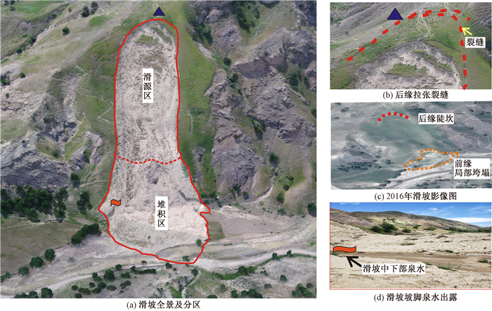
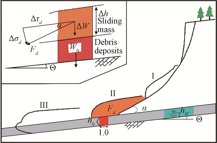
2018 Vol. 24, No. 5

Display Method:
Contents
2018, 24(5): .
Abstract (72) PDF (495KB)(4)
Abstract:
A STUDY ON FAULT STRESS CHARACTERISTICS AND THE LAW OF OIL AND GAS CONTROLLING BY FAULT DEFLECTING: A CASE STUDY OF THE NANPU DEPRESSION
MA Qiang, DELEQIATI·Jantay, CHEN Yajun, MA Le, YU Jingwei, QI Liqi
2018, 24(5): 587-597. doi: 10.12090/j.issn.1006-6616.2018.24.05.059
Abstract (207) HTML (77) PDF (4971KB)(14)
Abstract:
In order to find out the control effects of faults on the macroscopic distribution of oil and gas and look for the oil and gas accumulation zones with exploration potential, taking the geomechanics theory as a guide, the combined stress characteristics of faults, the fault deflecting and the causes in the Nanpu Depression are analyzed, and the oil and gas distribution law and favorable exploration zones in Dongying formation of the Nanpu Depression are studied combined with the characteristics of sand body distribution and ancient and modern tectonic stress field distribution. The results show that the fault deflecting controls the distribution of oil and gas, and the proven oil and gas in Dongying formation mainly shows a circular band distribution near the high curvature of the deflecting shaft of the broom-shaped fault system, the λ-type fault system and the interlaced-type fault system. The oil-controlling property on the concave side of the fault deflecting is obvious. Macroscopically, the oil and gas has the characteristics of selective migration along the sedimentary facies belt from fine to thick tectonic ridge highs and on the concave side of arc fault deflecting. The main direction of the oil and gas is determined by the favorable alignment of high curvature and high porosity, high permeability domain and high porosity, and high permeability sand body sedimentary facies zone in the fault deflecting shaft. The comprehensive study indicates that the Beibu structural belt in the Nanpu Depression is the primary zone for superior exploration in the future, followed by the Nanpu structural belt and the south of the Nanpu No.4 Getuo structural belt.
THE APPLICATION OF TWO FACTOR METHOD IN QUANTITATIVE PREDICTION OF TECTONIC FRACTURES: A CASE STUDY OF SHALE IN QING-1 MEMBER, SONGLIAO BASIN
WU Linqiang, LIU Chenglin, ZHANG Tao, GUO Hongzhou, XU Jingjing, JIANG Chengzhu
2018, 24(5): 598-606. doi: 10.12090/j.issn.1006-6616.2018.24.05.060
Abstract (195) HTML (75) PDF (2334KB)(18)
Abstract:
Qing-1 member of Qingshankou Formation in the Songliao Basin is an important hydrocarbon source formation and also the main development layer for fractured reservoir and shale oil reservoir. Fractures act not only as major pathways but also as important reservoir space. The evaluation of distribution pattern of fractures is instructive to the exploration and development of shale oil as well as fractured oil reservoirs. With finite element software ANSYS and Suffer to jointly model and by using software Petrel to simulate the rock mechanics parameters in three dimensional stochastically, the 3-D numerical simulation of plaeo stress field in late Paleogene is performed. The results show that the maximum principal stress in the study area varies from 24 to 147 MPa, and the minimum principal stress varies from 3.8 to 114.4 MPa. The area near Fuyu uplift zone is the low maximum principal stress area, while the area near Daqingchangyuan is the high maximum principal stress area. The distribution of the minimum horizontal principal stress in the low and high stress areas is approximately the same as that of the maximum horizontal principal stress. Based on the simulation, fracture density is predicted quantitatively through two factor method, with a relatively high reliability and coincidence rate of the measured one. The results show that the density in the Qijia-Gulong Depression, Daqingchangyuan and the Lishu-Dehui Depression is higher than other areas, which means they are the key exploration areas.
STRUCTURAL CHARACTERISTICS AND DIAGENETIC SEALING OF FAULTS IN THE BEISANTAI SWELL, JUNGGAR BASIN
ZHANG Lichen, WU Kongyou, HE Wenjun, CHEN Hong, ZHENG Menglin, JIA Xiyu
2018, 24(5): 607-616. doi: 10.12090/j.issn.1006-6616.2018.24.05.061
Abstract (212) HTML (88) PDF (3924KB)(13)
Abstract:
A fault has a complex internal structure, which can be divided into slip damage zone and induced fracture zone. The internal diagenesis of the fault zone is widely developed, and the cementation is the most important diagenesis in the induced fracture zone on both sides of the fault, which plays an important role in the vertical sealing of the fault. The structure of the main faults in the Beisantai swell is divided quantitatively by using seismic, logging and core information, and diagenetic cementation of fault zone is studied through core observation and microscope observation of thin section. The results show that the cementation of fault zone is obvious and there are various types of cement, mainly calcite; clay minerals, zeolite, quartz and other cement are also found in fractures. Compared with the derived faults, the fracture filling and cementation of large main faults are more intense, and the sealing performance of the oil and gas is stronger. The identification under microscope and the uniform temperature test of fluid inclusion suggest that there were at least three periods of great fluid activities in the Beisantai swell, and the multiple fluid activities lead to the diagenetic sealing of the faults in this area.
ACCUMULATION PATTERN OF ORGANIC MATTER IN SHALES OF THE LOWER CAMBRIAN NIUTITANG FORMATION, CHUANDONG-WULINGSHAN AREA
ZHOU Lei, WANG Zongxiu, LI Huijun, ZHANG Linyan, ZHANG Kaixun, LIANG Mingliang
2018, 24(5): 617-626. doi: 10.12090/j.issn.1006-6616.2018.24.05.062
Abstract (221) HTML (91) PDF (4349KB)(18)
Abstract:
The accumulation and preservation of organic matter have great guiding significance for the evaluation of oil and gas reservoirs and the survey and exploration of targeting exploration area. Based on the technologies and methods of lithogeochemistry, petroleum geochemistry and sedimentology, the richness and source of organic matter and paleoenviroment evolution of the Lower Cambrian Niutitang Formation in Chuandong-Wulingshan area were analyzed. The enrichment and preservation conditions of organic matter were evaluated preliminarily. The results show that planktonic algae (including blue-green algae, rhodophyta and phaeophyta) are the primary producers of organic matter. Compared with the upper domain of Niutitang Formation, during the deposition period of transgression, the warm and humid paleoclimate and large-scale transgression made the sea level rise rapidly, and the transgression caused deep continental shelf, slope and even shallow continental shelf to be in an oxygen-deficient or anoxic environment. This deep water oxygen-deficient and anoxic reduction environment (partial sulfide reduction environment) is favorable for the preservation of organic matter, and a large area of organic-rich shales were formed in the area of Chuandong-Wulingshan area.
ANALYSIS ON THE FORMATION AND ENRICHMENT CONTROL MECHANISM OF THE LOWER JURASSIC RESERVOIRS BY PALEO-GEOMORPHOLOGY OF WUQI AREA IN THE ORDOS BASIN
JIANG Daiqin, WEN Zhigang, TANG Renwen, HE Tongtong
2018, 24(5): 627-634. doi: 10.12090/j.issn.1006-6616.2018.24.05.063
Abstract (207) HTML (125) PDF (2388KB)(16)
Abstract:
In order to study the main controlling factors of the accumulation of Jurassic paleogeomorphic reservoir in Wuqi area, sedimentological paleogeomorphic restoration method was mainly used to describe the distribution of Jurassic paleodrainage system in Wuqi area according to the sand body thickness of the Fuxian Formation + Yan 10 Formation. Combined with the pre-Jurassic paleogeological characteristics of the Ordos Basin, the paleogeomorphic characteristics of the Wuqi area and the accumulation and enrichment of lower Jurassic were studied, and the hydrocarbon accumulation model was summarized. The results shows that there are three ancient terrains in Wuqi area:incised valley, slope zone and mound. The pre-Jurassic paleotopography controls the deposition of the early Jurassic strata and the distribution of oil reservoirs. The main channels for oil migration are the angle unconformity and the erosion between the Fuxian Formation and the Yanchang Formation and the thick high-permeable sand bodies in valley. At the same time, the high-permeable sand bodies also the main reservoirs of the lower Jurassic oil reservoirs. According to the spatial distribution of the lower Jurassic reservoirs, combined with various factors such as paleogeomorphology, sedimentary environment and micro-structural characteristics, three types of hydrocarbon accumulation models of Jurassic paleogeomorphology reservoirs in Wuqi area are summarized:slope model, mound model and paleo-valley model, of which mound model reservoirs are the most developed.
DETRITAL ZIRCON U-Pb AGES AND ITS PROVENANCE SIGNIFICANCE IN THE TZK3 CORE FROM THE YANGTZE RIVER DELTA
CHENG Yu, LI Xiangqian, ZHAO Zengyu, ZHANG Xiangyun, GUO Gang
2018, 24(5): 635-644. doi: 10.12090/j.issn.1006-6616.2018.24.05.064
Abstract (168) HTML (68) PDF (2727KB)(8)
Abstract:
Based on the magnetic stratigraphy of TZK3 core, the lithology, structural structure and zircon age characteristics of sediments were studied to explore the material source of sediments and running through time limit of the Yangtze River. The paleomagnetic results show that 96.7 m, 263.3 m and 603.75 m are B/M boundary, M/G boundary and boundary in the Pliocene, respectively. The plot of U-Pb age spectra for concordant zircons shows that the U-Pb zircon ages of the TZK3 Core are divided into five groups:100~300 Ma, 400~500 Ma, 700~850 Ma, 1800~2000 Ma, 2400~2600 Ma. The age spectrum of 3.7 Ma is relatively simple, mainly in the Cretaceous (100~150 Ma), and the materials are mainly from the volcanic basin in the middle and lower reaches of the Yangtze River. The zircon age spectrum becomes complex and there are relatively more main peaks since 3.04 Ma, indicating that the source area is wider and far-source components are involved. The appearance of zircons from the Emeishan basaltic age (251~260 Ma) in the zircon age of 3.04 Ma, indicating that the material in the upper reaches of the Yangtze River has reached the Yangtze River Delta region in this period. So the running through time limit of the Yangtze River is 3.04~3.7 Ma
DISCUSSION ON THE CONTINENTAL JURASSIC-CRETACEOUS BOUNDARY IN THE SICHUAN BASIN
LIU Gang, DONG Shuwen
2018, 24(5): 645-660. doi: 10.12090/j.issn.1006-6616.2018.24.05.065
Abstract (374) HTML (131) PDF (3757KB)(11)
Abstract:
The Jurassic/Cretaceous is one of the boundaries that do not yet have an accepted global boundary definition. The Berriasian stage is traditionally defined as the Cretaceous base according to ammonites. The geochronology age of basalt bedrock at the bottom of the Berriasian stage in Shatsky Rise, Northwest Pacific is 145Ma, which provides the closest estimate age of the Jurassic/Cretaceous boundary. The international stratigraphical division and correlation are based on marine standard, Jurassic and Cretaceous strata in China are mostly of continental strata which are difficult to compare with international standard strata. Therefore, the dominant opinion on Jurassic/Cretaceous boundary in the Sichuan Basin has not been renewed for a long time. Based on a comprehensive analysis of paleontological, geochronologic and paleogeomagnetic studies, good results are expected. The youngest detrital zircon U-Pb age is ~120 Ma, which reflects a depositional age of younger than ~120 Ma.The detrital zircon U-Pb age of Suining Formation shows that this widespread formation should be assigned to the Cretaceous, not the Jurassic. If it is the case, the transition beds of the Jurassic/Cretaceous would be down to Shaximiao Formation and Suining Formation. Based on systematic study, the indicators or markers of the Jurassic/Cretaceous boundary would be obtained from Shaximiao Formation and Suining Formation.
ZIRCON U-Pb AGES AND GEOCHEMICAL CHARACTERISTICS OF THE SUGAITILIKE LATE SILURIAN GRANITES IN SOUTHERN KUDI, XINJIANG AND ITS GEOTECTONIC SIGNIFICANCE
ZHUAN Shaopeng, BAI Chundong, MAO Zhifang, LI Dian, ZHANG Xinzheng, CHEN Yuanyuan, LIAN Qing
2018, 24(5): 661-669. doi: 10.12090/j.issn.1006-6616.2018.24.05.066
Abstract (236) HTML (87) PDF (3267KB)(6)
Abstract:
There are different opinions about the division of post-collisional stages of the Early Paleozoic Proto-Tethys Ocean in the West Kunlun area. In this paper, researches including regional geological survey, petrology, geochemistry, zircon U-Pb chronology, etc. were carried out on Sugaitilike granites, south side of Kudi ophiolite, which provide a geological basis for the tectonic evolution and closing time limit of the Proto-Tethys Ocean. The results show that, the age of zircon U-Pb(LA-ICP-MS) is 422.5±2.5 Ma, making granites products of the late Silurian magma activities. Sugaitilike granite contains typical mineral muscovite, A/CNK=1.07~1.11, and the content of corundum is 1.07~1.56%, belonging to S-type granite. Geochemically, the rock body is rich in silicon, alkali, calcium-depleted, magnesium-rich, rich in K, Rb, Nb, Th, lean in Sr, Ti, P, and high in Rb/Sr ratio. The comprehensive analysis of the geological background and geochemical characteristics of the Sugeitik granite area shows that granites are the products of the collision phase of the Proto-Tethys Ocean. Therefore, the late Silurian is the transition period from the closing of the Proto-Tethys Ocean to the collision of land and land-the period of post-collisional extension transformation.
A SMALL-SCALE MODEL OF SOFT MATERIALS USED FOR STUDYING THE UNDERGROUND MINING INDUCED DDISCONTINUITY PLANE DEFORMATION
LU Rong, MA Fengshan, GUO Jie, GUO Huigao, KOU Yongyuan
2018, 24(5): 670-675. doi: 10.12090/j.issn.1006-6616.2018.24.05.067
Abstract (136) HTML (83) PDF (2209KB)(6)
Abstract:
In order to study surrounding rock deformation and fault activation caused by underground mining, a small-scale model of soft materials is adopted to simulate the s discontinuity plane deformation induced by underground mining. The bending of a horizontal discontinuity plane after activation is studied through the model by simulating the deformation of the surrounding rock at the top of a rectangular underground mining area. The simulation results show that the shear displacement distribution on the discontinuity plane has the feature of bimodal curve, which is verified by numerical simulation. At the same time, the validity of this method is proved. The biggest advantage of this method is that the small-scale model can effectively simulate the deformation of surrounding rock caused by underground mining under the action of self-weight stress, with simple experimental equipment, short time, convenient operation and low cost. It is a physical simulation method worth popularizing.
DISCRETE ELEMENT SIMULATION OF SAND CONFINED COMPRESSION TEST BASED ON MatDEM
QIN Yan, LIU Chun, ZHANG Xiaoyu, DENG Shang
2018, 24(5): 676-681. doi: 10.12090/j.issn.1006-6616.2018.24.05.068
Abstract (168) HTML (49) PDF (2427KB)(11)
Abstract:
Discrete element method is suitable for numerical simulation of discrete mesoporous media such as sand, because discrete element method is based on discontinuous medium mechanics theory. A 3D discrete element simulator for sand confined compression test was developed by the discrete element simulation software MatDEM. Confined compression tests for 3 different graded sands were carried out, and the numerical simulation matched with the test was carried out. The validity of the developed simulator was verified by the comparison between the test and numerical simulation results. The results show that DEM can well reflect the change of the coordination number in the compression process of sand; in each sample, the elements with smaller size are subjected to greater average pressure, which leads to a larger average displacement; the main error of numerical simulation was caused by the Poisson's ratio of the discrete element particle. This study overcomes the limitations of the conventional soil mechanics research methods, and provides a reference for the study of the discrete element simulation of geotechnical engineering in the future.
ANALYSIS OF INFLUENCE OF DEEP FOUNDATION PIT CONSTRUCTION ON DEFORMATION OF ADJACENT SUBWAY STATION AND SHIELD TUNNEL IN SOFT SOIL AREA
LV Gaole, YI Lingbing, DU Mingfang, LI Shuaibing
2018, 24(5): 682-691. doi: 10.12090/j.issn.1006-6616.2018.24.05.069
Abstract (186) HTML (89) PDF (3766KB)(11)
Abstract:
Taking the bilateral deep foundation pit construction in some soft soil area adjacent to the subway station and shield tunnel as an example, using the numerical calculation software ABAQUS to carry out the numerical simulation of bilateral deep foundation pit construction, The influence of the construction process on the soil uplift in the foundation pit and the soil settlement outside the pit is studied, the deformation conditions of the subway station and shield tunnel were analyzed and the regularity were obtained. The calculation results show that the maximum value of soil uplift inside the foundation pit is 54.3 mm. The maximum x-direction displacement of the surrounding structure is 32.8 mm and the maximum y-direction displacement is 26.8 mm. The maximum vertical displacement of the station occurs from excavation to pit bottom in area A1, with a maximum value of 6.8 mm, while the maximum horizontal displacement of the station is 7.6 mm. The maximum cumulative increment of bending moment is 155.9 kN·m/m. The maximum x-directional horizontal displacement of shield tunnel is 4.7 mm. The maximum settlement value of shield tunnel is 3.8 mm, which occurs when the tunnel is excavated from area A1 to the bottom of the pit.
ANALYSIS OF FACTORS INFLUENCING THE PROPAGATION OF MINING BLASTING VIBRATION WAVE IN KARST AREA
CHEN Xuejun, YU Sizhe, SONG Yu, LI Jiaming, CHEN Yicheng, CHEN Lijie, ZHAO Zhiyong, YANG Yue
2018, 24(5): 692-698. doi: 10.12090/j.issn.1006-6616.2018.24.05.070
Abstract (238) HTML (101) PDF (3239KB)(3)
Abstract:
The field blasting vibration test was carried out on the Pb-Zn mining area of Shuikoushan in Hunan, and the measured data of Gudan Pb-Zn mine were used for comparison and analysis. Four test lines were set up in the area and eight sets of blasting vibration data were received. The collected data were calculated by Sodev's regression correction formula. Vibration wave frequency and vibration velocity were used as test indexes. Based on the measured data, the frequency of blasting vibration wave, the transmission speed in the medium and the peak particle vibration velocity of seismic wave caused by the decay of rule and influencing factors were determined, so as to study the influence of the decay regularity and vibration of blasting vibration on karst collapse under different condition, providing reliable basis for reasonable exploitation of local mines and reducing the occurrence of ground collapse disaster. The experimental results show that mining activity is the main influencing factor of karst ground collapse. The frequency of blasting vibration wave attenuation is related to its propagation distance and fault in the rock mass strength. The wave propagation velocity is influenced by factors such as characteristics of rock and soil, rock stratum and rock strata direction.
RESEARCH ON DYNAMIC CHARACTERISTICS OF THE KALAYAGAQI LANDSLIDE IN YINING COUNTRY, XINJIANG
YANG Longwei, WEI Yunjie, WANG Wenpei, ZHU Sainan, ZHANG Nan
2018, 24(5): 699-705. doi: 10.12090/j.issn.1006-6616.2018.24.05.071
Abstract (221) HTML (92) PDF (2975KB)(14)
Abstract:
Based on the study of dynamic characteristics of high speed long distance loess landslide, a simulation method for spatial prediction of high speed long distance loess landslide is proposed. Taking the Kalayagaqi loess landslide as an example, according to the field geological survey and aerial photograph images of the unmanned aerial vehicle, combined with the engineering geological conditions of the landslide research area, the basic features and formation conditions of the landslide are analysed. The study shows that the main inducing factor of the landslide is the infiltration of melted ice water, and there are mainly four disaster-inducing stages:Firstly, because of the concentration of stress at the top of the mountain, crack phenomenon appears in the trailing of landslide; Secondly, the mountain is covered with snow, and the loess joint fissure are enlarged by the effect of frost heave. Thirdly, due to the rising temperature and the infiltration of melted ice water, the sliding resistance of the landslide is gradually reduced. At last, the landslide lost its stability and slips at a high speed. The Rapid model was used to simulate the whole process of the kalayagaqi landslide. The results show that the duration of the landslide movement is 26 s, the maximum motion speed is up to 22 m/s and the average thickness of the accumulation body reaches 5 m. It proves that the Rapid model can be used to simulate and analyze the dynamic effect of high speed long distance loess landslide, providing reference for the analysis of the disaster-inducing mechanism and dynamic effect of similar landslides in the loess area.
APPLICATION OF INSULATION BOARD IN ROAD ENGINEERING IN PERMAFROST REGIONS OF INNER MONGOLIA
ZHANG Baolong, FAN Wen
2018, 24(5): 706-713. doi: 10.12090/j.issn.1006-6616.2018.24.05.072
Abstract (169) HTML (65) PDF (2957KB)(3)
Abstract:
Based on the meteorological engineering geological data, observation data and design data along the Bo-Ya expressway, a numerical calculation model of the roadbed temperature field was constructed by means of finite element software, and the influence of XPS insulation board on temperature field under different subgrade filling height was studied emphatically. The results show that, the increase of the subgrade height and the application of XPS insulation board both play a positive role in protecting permafrost. With the same embankment filling height, the temperature of permafrost of the subgrade with XPS insulation board reduces by about 0.19℃ than that of the subgrade with crushed rocks when the road runs to its twentieth years. XPS insulation board makes the upper limit of permafrost obviously raised, and the average uplift of the upper limit of permafrost is about 1.23 m under the same subgrade height. The upper limit of permafrost of subgrade with XPS insulation board is located in the replaced crushed rocks during the specified years of the designing code. However; the application of XPS insulation board aggravates the development of sunny-shady slope effect, the subgrade height with crushed rock should be kept above 3 m, and the subgrade height with XPS insulation board should be kept no more than 2 m.
STUDY ON GROUND SETTLEMENT OF ENGINEERING SITE OF METRO TUNNEL ADJACENT TO GROUND FISSURE ZONE UNDER THE ACTION OF EARTHQUAKE
CHEN Xing, HUANG Qiangbing, LIU Nina, ZHAO Teng
2018, 24(5): 714-722. doi: 10.12090/j.issn.1006-6616.2018.24.05.073
Abstract (224) HTML (82) PDF (5342KB)(4)
Abstract:
In order to study the law of ground settlement at the top of subway tunnel located on the hanging wall of ground fissure under the coupling action of earthquake and ground fissure and its influence on nearby buildings, taking Xi'an Metro Line 3 adjacent to the ground fissure site as the engineering background, with FLAC3D finite difference software and theoretical analysis, the ground settlement of engineering site with a metro tunnel adjacent to ground fissure zone under the action of three different seismic waves, namely Xi'an artificial seismic wave, El Centro wave and Kobe wave, are studied. The results show that the settlement of strata at the top of subway tunnel with a certain range is significantly greater than that of the surrounding strata under the action of earthquake, and a settlement groove with a width of 9~16 m is formed. The width of the settlement groove under the action of El Centro wave is the largest, about 15.9 m, and the Xi'an artificial synthetic seismic wave that exceed the probability of 10% is the second, about 11.6 m; The width of the settlement groove under the action of the Kobe wave is the smallest, about 9.5 m. The settlement law of the settlement groove accord with the peck formula. The settlement of the site surface with a range of 20 m at the top of the metro tunnel is the largest as a result of the coupling action of earthquake and ground fissure.
THE CALCULATION METHOD FOR OSMOTIC SUCTION OF SALINE SOLUTION
LI Xiaoyue, XU Yongfu
2018, 24(5): 723-729. doi: 10.12090/j.issn.1006-6616.2018.24.05.074
Abstract (280) HTML (89) PDF (2873KB)(24)
Abstract:
When bentonite cushion contacts with surrounding rocks in a disposal repository of highly radioactive waste, its mechanical properties will be affected by the saline solution contained in surrounding rock cracks, and the osmotic suction of salt solution will add additional stress similar to vertical load on bentonite. Therefore, quantifying the effect of saline solution on the mechanical properties of bentonite is of great significance for evaluating the safety of underground repository. Osmotic coefficients as the key to calculate the osmotic suction are usually obtained by complex tests, which obstructs the practical engineering applications. The Debye-Hückel formula are introduced to calculate the osmotic coefficients and osmotic suction for monovalent ion electrolyte, 2-2 type electrolyte and mixed electrolyte solutions. The impact of various factors on solution suction coefficients, such as solvent type, solute type, solute concentration and temperature are analyzed. Then the calculation method of osmotic suctions of different solutions are obtained. Based on the Debye-Hückel formula, the influence of solvent type and temperature on the osmotic suction coefficient is analyzed. The results show that the larger the solvent polarity, the larger the osmotic suction coefficient; the higher the temperature, the smaller the osmotic suction coefficient.
EXPERIMENTAL STUDY ON THE LATERAL FLOW SLIDE MECHANISM OF SATURATED LOESS MASS
ZHANG Xiaochao, PEI Xiangjun, JIA Jun, SUN Pingping
2018, 24(5): 730-736. doi: 10.12090/j.issn.1006-6616.2018.24.05.075
Abstract (145) HTML (50) PDF (3173KB)(7)
Abstract:
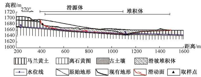
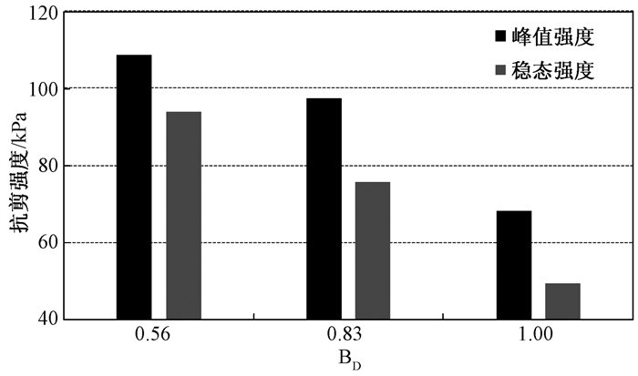
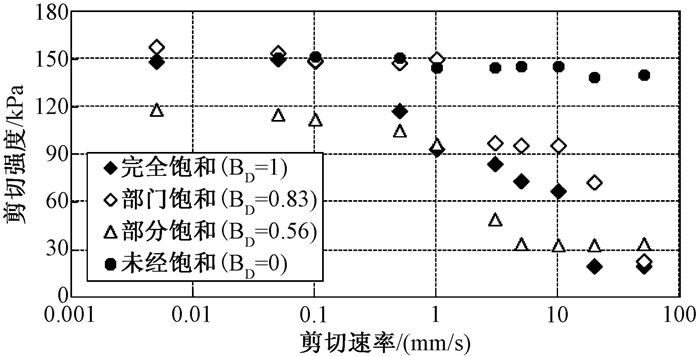
In 1920, the Haiyuan Ms 8.5 strong earthquake induced many loess liquefaction landslides, which were characterized by low angle, long distance, fluidization, and even phenomenon of large-scale horizontal lateral spreading flow slide happened, and the special formation mechanism is quite controversial. The Shibeiyuan landslide was one of the most typical examples of these landslides. Based on the detailed exploration of Shibeiyuan landslide remains, with the application of the DPRI-5 ring shear apparatus, the stability deformation characteristics of the liquefied saturation loess was studied and the influence laws of factors like consolidation pressure, saturability and shearing speed on the steady state strength of loess was discussed. The research indicates that the dynamic load level and its action mode affect considerably the stress-strain of loess and the developing law of pore water pressure; at the same void ratio, the steady state strength of saturated loess is not affected by early stress path, but related to consolidation pressure, saturation, loading rate and so on. The main conclusions are as follows:1Under the undrained shear condition, the higher the consolidation pressure gets, the slower the pore pressure response, and the higher the steady state strength gets2 The higher the saturation of loess gets, the faster the pore pressure response and the lower the steady state strength gets. 3 Shearing rate has a certain weakening effect on loess strength. When the shearing rate is within the scale of 0.1 mm/s, it poses little effect on the steady state strength; when the shearing rate ranges from 0.1 to 1 mm/s, the steady state strength reduces to various degree as the shearing rate increases; when the shearing rate is more than 1mm/s, the steady state strength tends to be constant because the increase of shearing rate would reduce the effects. In general, the higher the saturation degree is, the greater of the weakening effect of the shearing rate poses on the steady state strength. It reveals that steady deformation characteristics and the disaster-inducing mechanism of horizontal lateral flow slide of the Shibeiyuan saturated loess layer under low steady state strength.