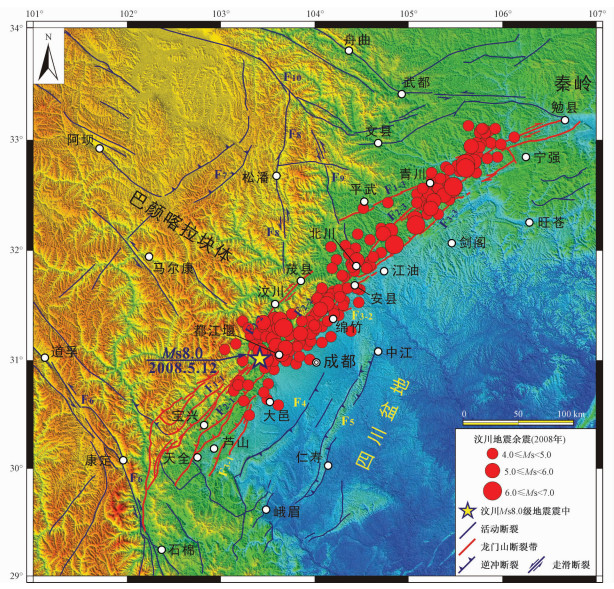
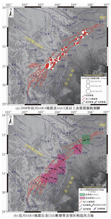
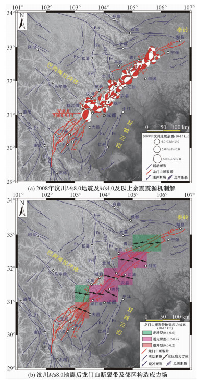
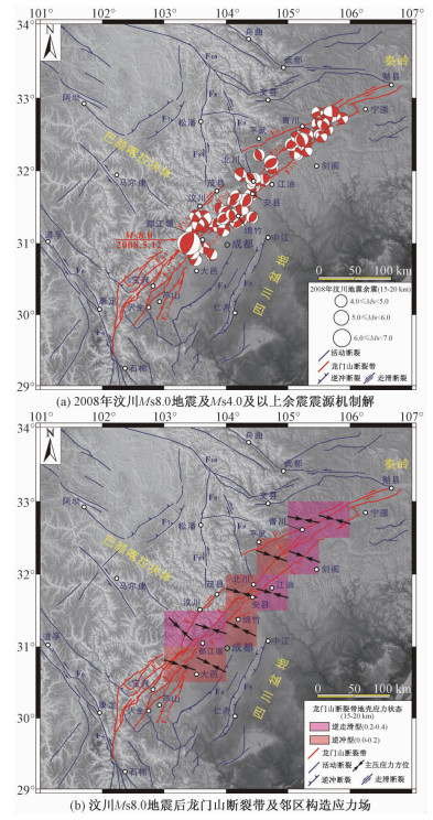
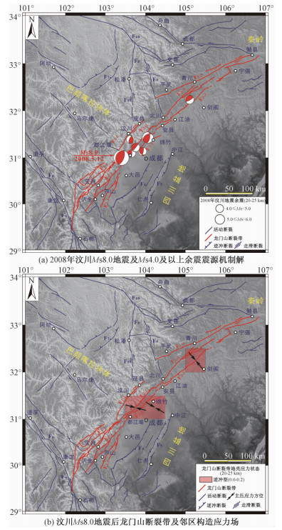
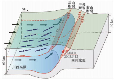
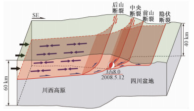
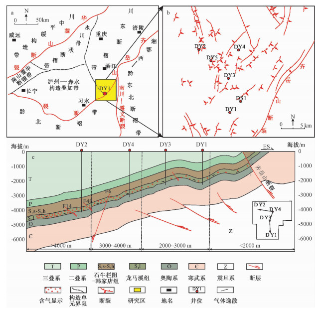
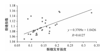
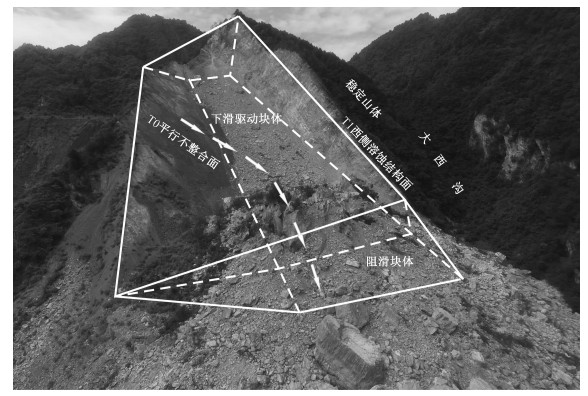
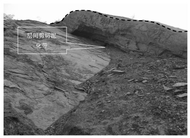
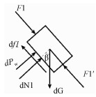
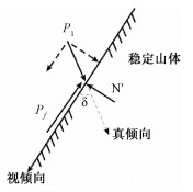
2018 Vol. 24, No. 4

Display Method:
Contents
2018, 24(4): .
Abstract (75) PDF (383KB)(8)
Abstract:
CRUSTAL STRESS FIELD AND ITS TECTONIC SIGNIFICANCE NEAR THE LONGMENSHAN FAULT BELT, AFTER THE WENCHUAN Ms8.0 EARTHQUAKE
FENG Chengjun, QI Bangshen, ZHANG Peng, SUN Dongsheng, MENG Jing, NIU Linlin, WANG Miaomiao, TAN Chengxuan, CHEN Qunce
2018, 24(4): 439-451. doi: 10.12090/j.issn.1006-6616.2018.24.04.046
Abstract (269) HTML (125) PDF (5060KB)(22)
Abstract:
The great Wenchuan Ms8.0 earthquake of May 12, 2008 occurred on the central segment of the Longmenshan Fault Belt. Stress was released when the earthquake struck and stress field of seismic source and peripheral areas were affected. Due to the spatial difference in rapture mode and intensity of fault in the Wenchuan earthquake, the crustal stress field in the Longmenshan Fault Belt should also show various features after the earthquake. So far, there have been few in-depth analysis and discussion on this scientific problem. In this study, the hydraulic fracturing in situ stress measurement data along the Longmenshan Fault Belt as well as the focal mechanism solutions of the strong aftershocks sequences after the Wenchuan earthquake are collected and analyzed, and the mid-upper crustal tectonic stress field of the Longmenshan Fault Belt is determined. The influences of the Wenchuan earthquake on the crustal tectonic stress field are thoroughly discussed through comparing with the regional tectonic stress before the great earthquake, which provides a scientific reference for understanding the stress adjustment process after the Wenchuan earthquake and the deep structural deformation model of the Longmenshan area on the eastern margin of Qinghai-Tibet Plateau. The results reveal that some distributional diversity of the crustal tectonic stress field does exist. At the depth of 0~15 km, the maximum principal stress is orientated at NWW near the Yingxiu-Qingchuan segment of the Lonmenshan Fault Belt and the stress state is characterized by TS, whereas, it is NEE with the SS stress regime at the northeastern Qingchuan area. At the depth of 15~25 km, the principal compressive stress is still orientated at NW~NWW with the broad stress state of TT, which is consistent with the regional tectonic stress field before the Wenchuan earthquake. The NWW-trending compression tectonic stress field beneath the middle crust of the Longmenshan Fault Belt further supports the rigid collision tectonic deformation in the Longmenshan area with collision-compression and thrust-nappe structures.
STUDY ON FAULT SEALING OF ORGANIC-RICH SHALE BY PRESENT STRESS: A CASE STUDY OF LONGMAXI FORMATION IN DINGSHAN AREA, SOUTHEAST SICHUAN
ZHONG Cheng, QIN Qirong, ZHOU Jiling, HU Dongfeng
2018, 24(4): 452-464. doi: 10.12090/j.issn.1006-6616.2018.24.04.047
Abstract (158) HTML (94) PDF (3356KB)(17)
Abstract:
The study of fault sealing has important reference value and guiding significance for the preservation and evaluation of oil and gas reservoirs and exploration of the distribution of oil and gas. Based on the technologies and methods of FMI imaging logging, focal mechanism solution, field hydraulic fracturing, triaxial mechanical experiment, finite element 2D-σ method and so on, the direction, intensity of the present geostress and the rock mechanical properties of the Longmaxi Formation in Dingshan area were analyzed. The sealing property of faults near well location was evaluated preliminarily. The results show that the direction of the present ground stress is generally from NEE-SWW(55°±5°)to SEE-NWW(110°±5°). The maximum principal stress of the Longmaxi Formation is about 145.0 MPa in the Well DY2, and the superimposed normal stress on the fault plane is about 188.4 to 218.3 MPa. The rock is in the plastic deformation stage with a simple fracture mode, generally good fault sealing, gas-bearing properties and test results, the brittleness index about 41.6% to 49.0% and the burst factor about 0.197 to 0.355.The present maximum principal stress of shale formation in the Longmaxi Formation of the Well DY1 is about 52.0 MPa, and the superimposed normal stress of the fault plane is about 75.8 to 83.1 MPa. The rock in the Longmaxi Formation of the Well DY1 is in the elastic deformation stage with a more complex fracture mode, generally bad fault sealing, gas-bearing properties and test results, the Rickman brittleness index about 48.5% to 55.0% and the rock fracture coefficient about 0.355 to 0.671. The fault sealing near shale formation of the Longmaxi Formation in the well DY3 and the well DY4 are generally normal.
THE COMPARATIVE ANALYSIS OF DIFFERENT METHODS FOR FRACTURE PREDICTION IN COMPLEX CARBONATE ROCK RESERVOIR
ZU Kewei, CHENG Xiushen, LUO Zhouliang, YIN Nanxin, WANG Kai
2018, 24(4): 465-473. doi: 10.12090/j.issn.1006-6616.2018.24.04.048
Abstract (143) HTML (62) PDF (2645KB)(9)
Abstract:
Taking Jialingjiang formation in Puguang area as an example, with the fractures development law drawn in the area as a basis, the structural curvature method, S-wave wide azimuth anisotropy method and finite element method were used in fracture prediction, and the results and application conditions of each method were compared. The results show that the curvature method based on the geometry theory could be used to analyze the intensity of fracture development but not the azimuth. It fits in the area with fewer data, simple structure and folds. The S-wave wide azimuth anisotropy method is a preferred geophysics method, which could identify the azimuth and development density of the fracture; however, this method only fits in the area with dipping or high-angle fracture and requires a high quality of seismic data; The finite element method (FEM) could reappear the forming process of fractures in the way of forward and calculate the development intensity and azimuth, but it requires a good understanding of the fracture formation mechanism in the study area, and the accuracy of the prediction results depends on the precision of the model.
STUDY OF DISASTER-INDUCING GEOLOGICAL CONDITIONS OF COLLAPSE AND LANDSLIDE ALONG LULANG-TONGMAI IN SE TIBET
ZHANG Jiajia, CHEN Long, WANG Junchao, LI Yuanling, GAO Bo, SHI Shengwei
2018, 24(4): 474-481. doi: 10.12090/j.issn.1006-6616.2018.24.04.049
Abstract (268) HTML (104) PDF (3670KB)(15)
Abstract:
Eastern Himalayan Syntaxis, as one of the fastest uplifting region in Tibetan Plateau, its complex geological environment determines that the engineering geological problems have complexity and particularity and give birth to a variety of geo-hazards. Based on the survey results of the project "Geo-hazards investigation in main towns and major highways in SE Tibet", the geological conditions of landslides along Lulang-Tongmai were analyzed. According to the analysis, the study area could be divided into four sections, respectively, which are Lulang-Dongjiu section, Dongjiu-Layue section, Layue-Pailong section, Pailong-Tongmai section. Each section corresponds to different disaster-inducing geological conditions, which determines the nature, deformation and failure mode and scale of landslide in the section. The conclusion could be used in risk assessment and early identification of landslides in SE Tibet.
MECHANICAL ANALYSIS OF APPARENT DIP BUCKLING MECHANISM OF STEEP STRATIFIED OBLIQUE ROCK: A CASE STUDY OF SHANYANG ROCKSLIDE IN SHAANXI PROVINCE
WANG Jiayun, SHI Xiaoya
2018, 24(4): 482-489. doi: 10.12090/j.issn.1006-6616.2018.24.04.050
Abstract (176) HTML (94) PDF (3664KB)(11)
Abstract:
Taking Shanyang rockslide in Shaanxi province for example, the apparent dip slide characteristics, and creep-buckling failure mode and mechanism of steep stratified oblique rock are analyzed. Based on the beam theory and mechanical model of bending-buckling failure of stratified slab-rent structure rockmass, the mechanical model of buckling failure of steep stratified oblique rock is established through structural-mechanical analysis of rock mass, taking into consideration of gravity of slope, hydrostatic pressure of groundwater and lateral friction of apparent dip slide of inclined bedding rock. The corresponding condition equation of buckling length is derived afterwards. The result of checking computation on Shanyang rockslide is basically consistent with the practical result, which indicates that the condition equation is correct. And it can provide references for the prevention of apparent dip buckling failure of steep stratified oblique rock.
STUDY ON DYNAMIC RESPONSE OF LANDSLIDE SUPPORTED BY PRESSURE-TYPE ANCHOR UNDER EARTHQUAKE
LI Nan, WANG Banqiao, MEN Yuming, ZHANG Miaozhi
2018, 24(4): 490-497. doi: 10.12090/j.issn.1006-6616.2018.24.04.051
Abstract (180) HTML (60) PDF (2881KB)(8)
Abstract:
In order to study dynamic response of anchorage landslide and mechanical behaviors of pressure-type anchor under earthquake, the finite element software ABAQUS was adopted and an anchorage landslide model supported by pressure-type anchor and lattice beam was established. On that basis, the acceleration response law of anchorage landslide, the effect of ground motion parameters on acceleration response of the model, and the mechanical behaviors of pressure-type anchor under earthquake were researched respectively. The results indicated that anchorage landslide had elevation amplification effect from bottom to top along with the landslide, and the acceleration response in crest was the strongest. Due to the spectrum characteristics of earthquake, acceleration response is different under different seismic waves. The anchorage landslide had an amplifying effect on lower frequency band and an attenuation function on higher frequency band. With the increase of loading amplitude, the acceleration response of anchorage landslide decreased first and then increased. For the same anchor, axial force distribution was nearly uniform; however, for the anchors at different elevation, axial force of anchors had a great difference, and the strain distribution of anchor body shows the "C"-type from bottom to top. The bottom anchor and the top anchor bear most of the loads. The research results could provide a reasonable foundation for the design of the pressure-type anchor under earthquake.
RESEARCH PROGRESS OF GAS SLIPPAGE EFFECT IN COMPACT POROUS MEDIUM
RAN Yanxia, YE Bin, CHENG Zirui
2018, 24(4): 498-504. doi: 10.12090/j.issn.1006-6616.2018.24.04.052
Abstract (270) HTML (111) PDF (1690KB)(13)
Abstract:
The gas seepage in compact rock media is different from fluid seepage. The gas slippage effect is an important factor affecting gas flow in compact porous media. This paper summarizes the research progress on the gas slippage effect and synthetically analyzes the production mechanism and conditions of slippage effect, considering that the motion state of gas molecules near the pore wall contributes to the slippage effect of the gas. In addition, the effect of pore gas pressure, confining pressure, water saturation, gas properties, and other factors on the effect of gas slippage and its essence are studied and analyzed. It is of great reference for studying gas flow law in low permeability medium and measuring the gas permeability parameters in the development of low-permeability gas fields, etc.
THE CURRENT SITUATION OF DESERTIFICATION IN THE HONGSIBU BASIN, NINGXIA, AND ITS MAIN GEOLOGICAL CONTROLLING FACTORS
HUANG Ting, LI Zhenhong, LIU Feng, CUI Jiawei, DONG Xiaopeng, ZHAO Yang
2018, 24(4): 505-514. doi: 10.12090/j.issn.1006-6616.2018.24.04.053
Abstract (219) HTML (137) PDF (3796KB)(8)
Abstract:
Based on the landsand-TM remote sensing images, the desertification evolution history of the Hongsibu Basin in the last 30 years is rebuilt. Combining with the 1:50000 geological mapping, the Late Pleistocene sedimentary frame is systematically built and the lithofacies paleogeography for several important evolutional phases of the Hongsibu Basin is reconstructed. Moreover, the provenance of the eolian sand by detailed geological field and sedimentary geochemical works is traced. According to the primary research, several cognitions can be suggested that Although the desertification had not been eliminated, the ecological migration strategy implemented in 1999 effectively curbed the deterioration of the ecological environment and the range of desertification decreased; The sand ridges at the surface with zonal distribution characteristics mainly extend in NW-SE direction which parallels with the strike of the Daluo Mountain-Niushou Mountain tectonic belts, and Yantong Mountain tectonic belts; The eolian sand piled during the desertification mainly derived from the loosened lacustrine sand deposits, the third part of the Upper Pleistocene Salawusu formation sedimented during the regression, and this process is characterized with in-situ desertification; The similarities of the eolian sand at the surface and the lacustrine sand from the third part of the Salawusu formation in major elements, trace elements, and REE aspects revealed the affinity between these two sets of sands. What's more, this study contributes a lot to the comprehensive control for the regional desertification in the Hongsibu Basin, Ningxia.
GRAIN SIZE CHARACTERISTICS OF TIANHENGSHAN CORE AND THEIR INDICATIONS FOR STRATIGRAPHIC DIVISION IN THE EASTERN PART OF THE NORTHEAST PLAIN OF CHINA
ZHAN Tao, ZENG Fangming, XIE Yuanyun, YANG Ye, MA Yongfa, GE Junyi, YI Liang, CHI Yunping, KANG Chunguo, JIANG Xia, ZHANG Jun, LOU Benjun, ZHOU Xin, DENG Chenglong
2018, 24(4): 515-521. doi: 10.12090/j.issn.1006-6616.2018.24.04.054
Abstract (216) HTML (119) PDF (2691KB)(8)
Abstract:
Huangshan Profile in the eastern part of the Northeast Plain is a typical Quaternary profile in Northeast China; however, there are different views on the stratigraphic division and stratigraphic origin of this section. A detailed study on its grain size characteristics is expected to provide further insight into the stratigraphic division and stratigraphic origin of the profile. In this paper, high resolution grain size characteristics of the sediments in Tianhengshan (THS) Core were studied and compared with those in typical loess profiles on the Chinese Loess Plateau. The results show that the mean grain size, median grain size and percentage fraction of grain size of Harbin Formation fluctuated widely, with coarser grains in the loess layer and finer ones in the paleosol layer, similar to those in the loess-paleosol sequence on the Chinese Loess Plateau. However, grain size characteristics in Huangshan Formation show small fluctuations, thus indicating relatively stable sedimentary dynamics. The characteristics of grain size, including frequency distribution, C-M diagram and other grain size parameters (mean grain size, standard deviation, skewness and kurtosis) in sediments between Harbin Formation and Huangshan Formation are obviously different, indicating that the sedimentary dynamics of the two groups are different. Based on the above characteristics of grain size, combining sedimentary facies and previous methods of classification, the middle-to late-Pleistocene strata of the THS Core from top to bottom is divided into Harbin Formation and Huangshan Formation, which are determined as aeolian accumulation and fluvial/lacustrine sediment, respectively.
FACIES ANALYSIS OF RED BEDS AND ITS RELATIONSHIP WITH THE DEVELOPMENT OF DANXIA LANDFORM IN LONGHUSHAN AREA OF JIANGXI PROVINCE: AN EXAMPLE FROM XIANRENCHENG SCENIC SPOT
LI Wenhao, CHEN Liuqin, GUO Fusheng, LI Pengcheng, WANG Yujia, LI Xinmin
2018, 24(4): 522-532. doi: 10.12090/j.issn.1006-6616.2018.24.04.055
Abstract (353) HTML (184) PDF (5650KB)(10)
Abstract:
Longhushan area is characterized by late-staged Danxia landforms with Late Cretaceous red beds of Hekou Formation as the scenery layer. Little is known about depositional facies of these redbeds. The outcrop of the Hekou Formation is more than 100 meters thick with abundant sedimentary structures. The man-made stone steps from the bottom to the top of the hill are favourable for performing detailed observation and measurement for facies analysis in Xianrencheng Scenic Spot in Longhushan area. Six lithofacies units are recognized based on the characteristics of lithology and sedimentary structures:structureless conglomerate, normal bedding conglomerate, inverse bedding conglomerate, parallel bedding conglomerate, pebbly sandstone, and paleosol. Pebble counting results show that gravels dominantly range from 3 cm to 4 cm with the largest one of 12.5 cm in diameter, and they are mainly composed of purple tuffs, followed by sandstones, granites, quartzite and minor amounts of metamorphic rocks (mainly schists). The roundness is mainly subangular, followed by angular. Under a microscope, the detrital grains of the interbedded sandstone samples are mainly angular to subangular, poorly sorted, 0.05~2.00 mm, composed of quartz, feldspar and rock fragments. Overall, the sandstone samples are featured by moderate to low textural and compositional maturities. Both the field macroscopic observation and microscopic analysis indicate that the redbeds were deposited by alluvial fan systems. Moreover, the spatial distribution of Danxia landforms and plane distribution of alluvial fan facies have good consistency. In particular, the coarse-grained sedimentary succession of alluvial fan facies along the basin margin provided the fundamental bedrock for the formation and development of Danxia landforms.
ZIRCON U-PB DATING AND GEOCHEMICAL FEATURES OF CHAHANCHAHA GRANITE FROM WESTERN TIANSHAN, XINJIANG: IMPLICATIONS FOR TECTONIC EVOLUTION
LIU Gaofeng, WANG Bin, CHEN Shihai, AI Haiping
2018, 24(4): 533-543. doi: 10.12090/j.issn.1006-6616.2018.24.04.056
Abstract (268) HTML (146) PDF (3679KB)(6)
Abstract:
The Chahanchaha granitic body outcrops in the southeast part of the western Tianshan Mountains, Xinjiang, and it is located in the Nalati-Central Tianshan intrusive rock belt at the northern edge of the fault, south margin of the Central Tianshan. The rock type is dominated by granodiorite and monzonitic granite with weak gneissic foliation. The zircon U-Pb dating results indicate that the Chahanchaha granitic rocks formed at 421±6.2 Ma. The geochemical characteristics suggest that the granitic rocks are grouped in metaluminouscalc-alkaline Ⅰ-type granite, which exhibits typical characteristics of intrusive rocks in the continental arc. These data demonstrate that the paleo-south Tianshan ocean crust has started northward subduction at late Silurian, resulting in a continental arc upon the overriding plate.
PROTOLITH RECONSTRUCTION AND GEOTECTONIC ENVIRONMENTAL RESEARCH OF XINGHUADUKOU ROCK GROUP IN LVLIN FORESTRY CENTER, DAXING'ANLING
JIA Limin, LIU Hongzhang, JU Jiaxing, LI Feng
2018, 24(4): 544-554. doi: 10.12090/j.issn.1006-6616.2018.24.04.057
Abstract (267) HTML (129) PDF (3986KB)(7)
Abstract:
Xinghuadukou Rock Group, as the basement of Ergun massif, its metamorphic age, protolith types and geotectonic setting has always been a hot spot for geologists. With Xinghuadukou Rock Group in lvlin forestry center, north part of Daxing'anling, as the research object, zircons U-Pb isotopic dating was used to define the metamorphic age of protolith. Protolith reconstruction was carried out combining with the comprehensive analysis methods of petrography and geochemistry, and its geotectonic setting was further discussed. The resarch suggests that Xinghuadukou Rock Group is mainly composed of amphibolite, leptite, granulite and quartzite. The protolith of these four kinds respectively are basic volcanic rock, dacite tuff, pelitic siltstone and pelitic siltstone. Amphibolite is lack of non-active trace elements Ta、Nd、P, and it belongs to the island-arc geotectonic environment. Leptite mainly lacks Ta、Nd、P、Sr、Ti and other elements, and it is formed in the orogenic belt environment of continental margin. The lower limit of metamorphic age of Xinghuadukou Rock Group in Lvlin forestry center is 774.1±3.8 Ma.
REVIEW OF CATEGORY AND DEVELOPMENT CONTEXT OF FAULT MECHANICS
GUAN Chengyao, ZHAO Guochun, BAI Xiangdong, YUAN Sihua, ZHANG Yan, LIU Xiaoyan
2018, 24(4): 555-586. doi: 10.12090/j.issn.1006-6616.2018.24.04.058
Abstract (154) HTML (184) PDF (4296KB)(30)
Abstract:
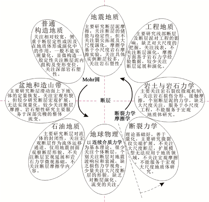
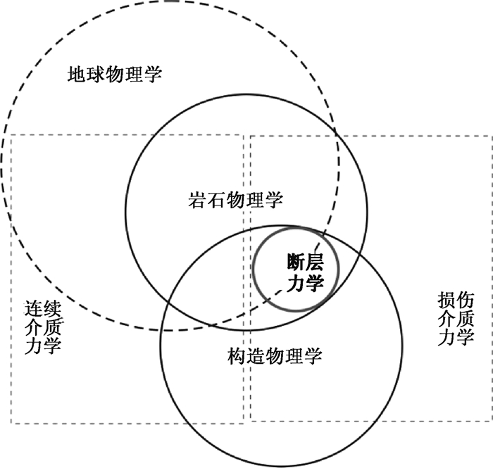
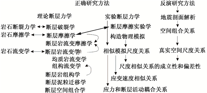
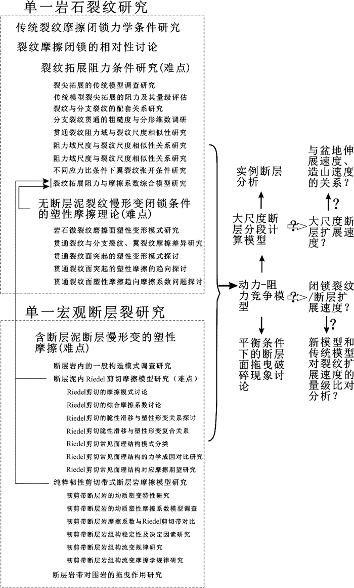
In order to reveal the whole-theory of fault mechanics, this paper reviews the development of fault mechanics, the due system, the lack of frame and summarizes the differences of academic concerns and research contents. The results show that there are scale differences and target differences in the correlation field of fault mechanics. Fault mechanics is a link in multi-disciplinary fields, yet it is still a zone no one to manage. There are differences in size and deformation velocity between rock cracks and faults with internal structures. The centennial development trajectory of fault research from external forces to fault-tectonic stress field and then to slip-line-field is a simplified and practical way, which hinders the development of quantitative theory. "Mohr paradigm" is the support, with practical and simplified features, which also hinders the development of fault mechanics towards mechanism and quantification. There are two kinds of methods in fault research, forward modeling and inversion. Forward modeling mainly includes experimental fault mechanics and theoretical fault mechanics. The combination of forward modeling and inversion is the future development direction. In accordance with the "unified law of mechanics", "geomechanics" embodies the spatial relation and mechanical relation of faults and belongs to the category of "generalized fault mechanics". The "generalized fault mechanics" system is applicable to the development of "unified development, concern and connection", while the "narrow sense mechanics" system is applicable to the development of "decentralized development, individual achieve". The pre-rift always controlling the secondary fault and influencing the stress distribution and the "theory of stress restriction" is an important direction in the future. "fault rheological tribology" and the "fault rock fabric tribology" will emerge as two directions in the future, and the "fault rock fabric tribology" should be integrated micro-tectonics, the stability of rock fabric characteristics, the rheological characteristics, generalized friction characteristic and so on. The microscopic structural phenomenology theory needs to be promoted to the large-scale fault mechanics theory, and rock fabric needs to be introduced to the rock mechanics experiment. Different scales have different concerns, different theories and different parameters, which aggravate the isolation of research groups. The mud-particles in faults can be migrated, resulting in "The theory of fault mud-particles transport". The concept of fault-locking needs to be reconsidered, and future research should be based on the "slow strain" and "large-scale" frictional extension mechanics of fault.