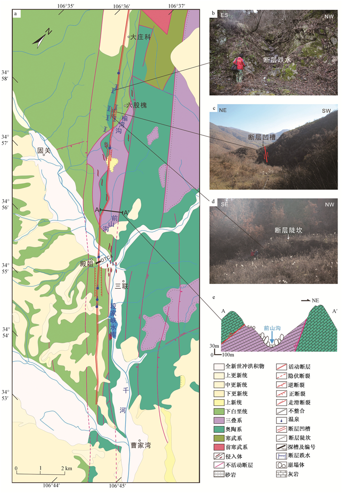
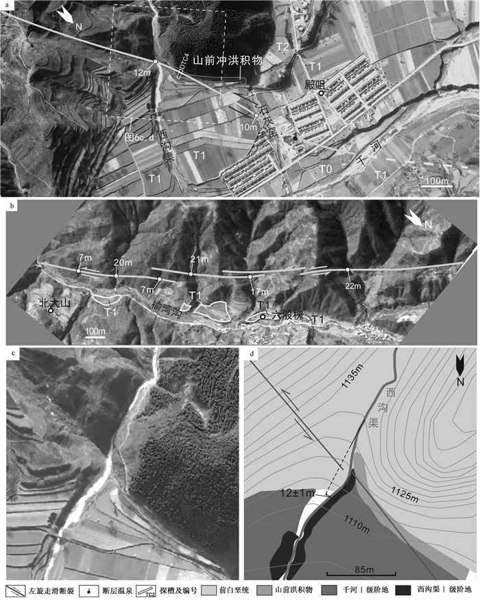
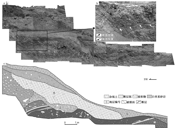
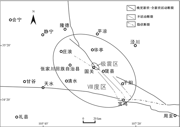
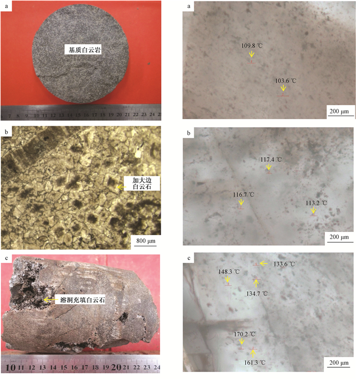
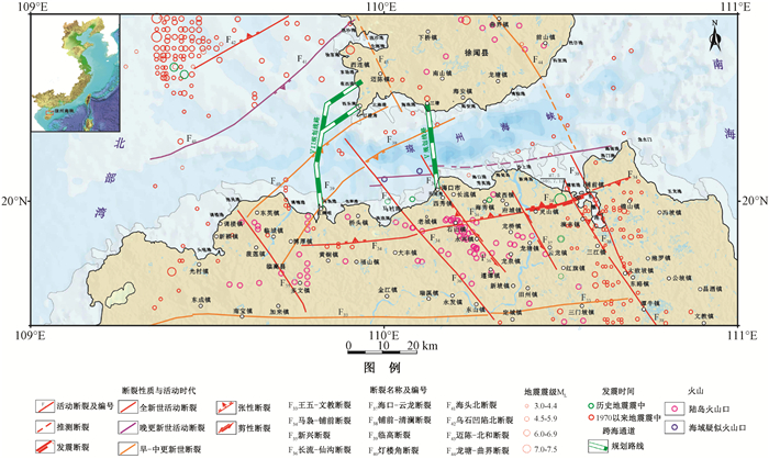
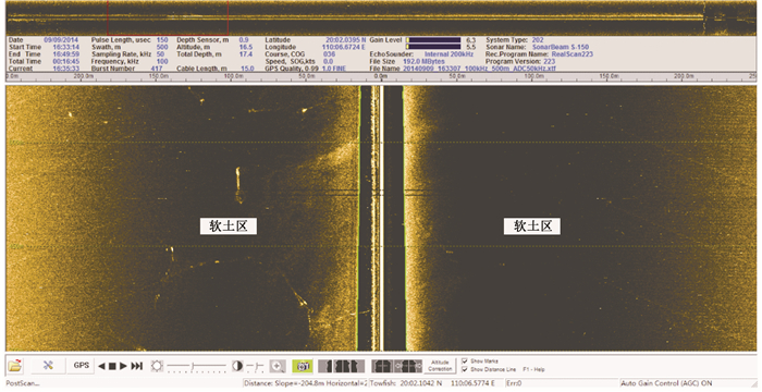
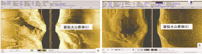
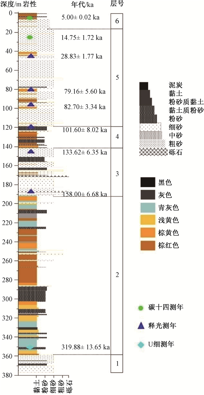
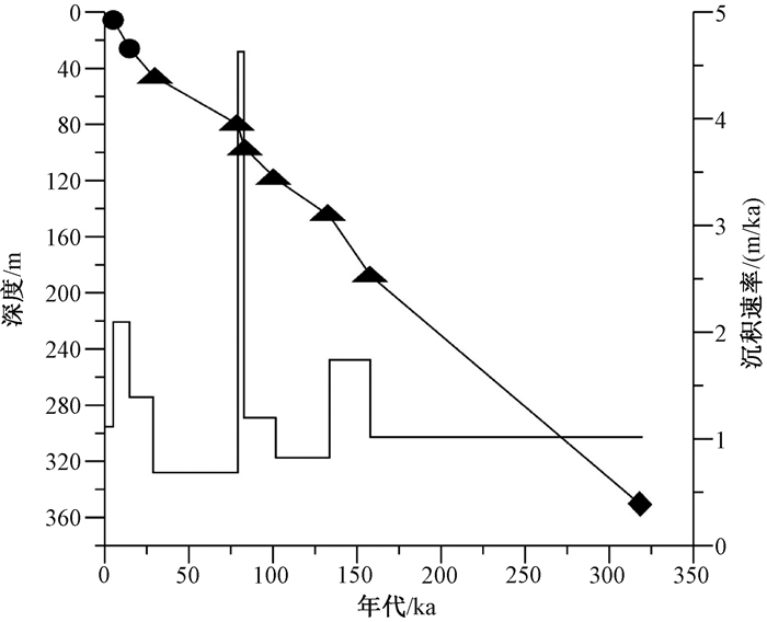
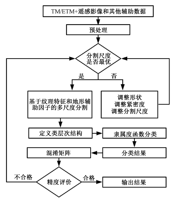
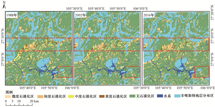
2018 Vol. 24, No. 2

Display Method:
ADVANCES IN CONTINENTAL SCAPE STRUCTURES
ZHANG Yu, SHI Wei
2018, 24(2): 145-156. doi: 10.12090/j.issn.1006-6616.2018.24.02.016
Abstract (381) HTML (100) PDF (2333KB)(40)
Abstract:
The continental scape structure, as one of the important structural styles to accommodate intracontinental deformation, is of great significance to understand intracontinental deformation, strain partitioning and formation mechanism during tectonic evolution of the continent. Based on the previous continental escape structures defined in structural belt, this paper synthesizes the formation mechanism, tectonic models and methods of continental scape structures. The structure is generally formed due to the limitation of conjugate Ⅴ-shaped structure at the end stage of continental collision, and it plays a key role in coordinating the transformation of stress regime. Mechanically, the formation of Ⅴ-shaped fracture zones coincides with the paired general-shear model and the preexisting structure activity criterion according to the Byerlee law and the Coulomb-Mohr fracture criterion. The escape models essentially include lateral escape and oblique extrusion. Structural analysis is essentially necessary in the definition of an escape structure, and tectonic modeling is a reliable tool to reconstruct and understand tectonic processes of continental lateral extrusion.
ANALYSIS AND TEXTUAL RESEARCH OF THE SEISMOGENIC STRUCTURE OF THE QIN-LONG EARTHQUAKE IN 600 A.D.
WANG Shidi, SHI Yaqin, REN Fengwen
2018, 24(2): 157-168. doi: 10.12090/j.issn.1006-6616.2018.24.02.017
Abstract (182) HTML (73) PDF (10641KB)(14)
Abstract:
According to Chinese historical records, an earthquake struck the ancient Qin-Long area in 600 A.D., and caused serious social impact. The epicenter, earthquake magnitude, epicentral intensity, and seismogenic structure of this earthquake have long been disputed. In this study, based on the earthquake collapses found in Guguan town, Longxian county, combined with multiple research methods including historical data verification, satellite images interpretation, field observation, geologic trench excavation, age dating, it shows that the seismogenic structure of the earthquake is the Guguan segment of east Liupanshan fault, and the epicenter should be located near Guguan town, Longxian county. Its magnitude was around 6$ {}^{3}\!\!\diagup\!\!{}_{4}\; $ and the epicentral intensity was inferred as Ⅸ. This study on the historical earthquake in this area has great significance to the earthquake hazard assessment in Liupanshan area and the understanding of the kinetic process of the northeastward expanding of the Tibet Plateau.
DYNAMIC MECHANISM OF RIFT SYSTEMS IN WEST AND CENTRAL AFRICA
ZHANG Qinglian, HOU Guiting, PAN Xiaohua
2018, 24(2): 169-176. doi: 10.12090/j.issn.1006-6616.2018.24.02.018
Abstract (223) HTML (73) PDF (2692KB)(23)
Abstract:
The rift systems in West and Central Africa that developed along the shear zone in Central Africa is a series of Mesozoic-Cenozoic rift basins, and their formation mechanism is still a matter of debate. The evolution of those rift systems has three stages, and Early Cretaceous is the most important one for the basin formation, in which the rifts and major fault zones were strongly active. Based on the geological setting of rift systems in West and Central Africa in Early Cretaceous, using linear elastic theory with two dimensional finite element numerical simulation, through the analysis of the stress field and the strain field, reliable evidence to the mechanical mechanism of rift systems are produced. The simulation results suggest that strike-slipping and extensional process coexist in African continent in Early Cetaceous, and the shear zone in Central Africa is not a "transform fault" but a structure that formed and developed simultaneously with the rift systems in West and Central Africa. In Mesozoic-Cenozoic Pangea disintegration period, due to the different motion rates of the three blocks along parallel slip vectors under the unified tectonic stress field and the counterclockwise rotation around WB by African plate, rift systems were formed and developed.
A PRELIMINARY STUDY ON THE ORE-CONTROLLING STRUCTURE IN TIANYU NICKEL DEPOSIT, EASTERN TIANSHAN MOUNTAINS, NW CHINA
CHEN Bailin, DONG Faxian, LI Songbin, CHEN Zhengle, HAN Fengbin
2018, 24(2): 177-187. doi: 10.12090/j.issn.1006-6616.2018.24.02.019
Abstract (166) HTML (78) PDF (4583KB)(13)
Abstract:
Tianyu nickel deposit is located in southeastern margin of east Tianshan block of the Trim Plate. It is closely related between the ore resource and the tectonics in east Tianshan area, while the Cu-Ni deposits are mainly controlled by regional deep-major fault zone (Kangguer fault and Yamansu Fault et al). The mainly outcropped lithology are medium-hypo metamorphic rocks of middle Proterozoic group and secoundarily are volcanic rocks and pyroclastic rocks of upper Paleozoic group in Tianyu deposit and its vicinity. Folds and faults are well developed with NEE-trending extension in the area, in which, Baihuguan composite anticline is a first-order fold and Shaquanzi fault (as a part of the Yanmansu fault) is a first-order fault. Gneissoid and augen structures of metamorphic rocks or deformed granites are also well developed, which indicates that ductile deformation had occurred. Detailed surface geology and tunnel survey reveal that, there mainly are NE-trending and SN(NNE)-trending faults in ore area. Some of the NE-trending faults control on the Ni ore body by means of controlling the emplacement and distribution of the Ni-bearing ultra-basic rocks. The SN(NNE)-trending faults developed and became active after the forming of the Ni ore body, and often offset ultra-basic rock and Ni ore body with sinistral sense of displacement. Nevertheless, there isn't an obvious sinistral sense of Ni ore body by SN(NNE)-trending faults in Tianyu ore area, and the main Ni ore body is complete and entire. The lens out of Ni ore body at northeast of CM12 on 1350m level was not caused by F8 fault, but resulting from a nature pinching out because of inhomogeneous nickel mineralization in ore-bearing ultra-basic rocks. The results of this study have important implications for the analysis of ore-controlling structure in eastern Tianshan mountains and all domestic copper-nickel deposits as well as the deployment of mining projects.
ZIRCON U-PB DATING, GEOCHEMICAL CHARACTERISTICS AND METALLOGENIC SIGNIFICANCE OF GRONODIORITE PORPHYRY FROM THE XIZANGDAGOU GOLD DEPOSIT IN EAST KUNLUN, QINGHAI PROVINCE
LI Jinchao, KONG Huilei, LI Yazhi, GUO Xianzheng, NAMKHA Norbu, WANG Xianxiao, JIA Qunzi, ZHANG Bin, YAO Xuegang
2018, 24(2): 188-198. doi: 10.12090/j.issn.1006-6616.2018.24.02.020
Abstract (213) HTML (131) PDF (3833KB)(7)
Abstract:
The Xizangdagou gold deposit lies in the Bayan Har tectonic belt of East Kunlun. LA-ICP-MS zircon U-Pb dating shows that the weighted mean age of granodiorite porphyry, which is closely related with the mineralization of the Xizangdagou gold deposit, is (225.0±1.2)Ma, in the Late Triassic. This suite of rocks are enriched in LILE (such as Rb, Sr, Ba, K), LREE and Pb, relatively depleting in HFSE (such as Nb, Ta, P, Ti), with rich LREE and low HREE. Based on the study of evolutionary characteristics of regional structures and chronologic data of gold deposits in East Kunlun, the authors suggest that the granodiorite porphyry in the Xizangdagou gold deposit was formed under a conversion tectonic setting from compressional to extensional, and the Xizangdagou gold deposit formed at 225.0~218.6 Ma, in the Late Triassic.
METALLOGENIC STRUCTCTURAL PLANE CHARACTERISTICS AND ITS PROSPECTING IMPORTANCE FOR THE MAKENG TYPE IRON DEPOSITS IN SOUTHWESTERN FUJIAN PROVINCE
WANG Sen, ZHANG Da, WU Ganguo, YI Jinjun, LI Xingjian, YU Tengda, BAI Yu, GAO Xiaoqiao
2018, 24(2): 199-211. doi: 10.12090/j.issn.1006-6616.2018.24.02.021
Abstract (272) HTML (191) PDF (3802KB)(15)
Abstract:
Located in the Late Paleozoic depression of southwestern Fujian, the Makeng type iron deposits are the main skarn iron polymetallic deposits. The major ore bodies are generally controlled by lithologic boundaries and tectonic structural planes, especially the interface between silica and calcareous bed, and they are located above the quartz sandstone of the Lower Carboniferous Lindi formation(C1l)and below the carbonate rocks of the Upper Carboniferous Jingshe formation-Upper Permian Qixia formation(C2j-P2q). In order to reveal the genesis and mineralization mechanism of the Makeng type iron deposits, the Si/Ca surface ore-controlling theory was used to discuss the metallogenic structctural plane characteristics and its ore-controlling mechanism. Five types of metallogenic interfaces were divided according to their features in this research. We deemed that the main ore bodies of Makeng type iron deposits were controlled by the physical and chemical differences between these Ca/Si surfaces, and it is easy to form expansion space and geochemical barrier near the surfaces in the process of tectonic and fluidic activities. Based on the understanding above, the metallogenic model of the Makeng type iron deposits was built using the Si/Ca surface ore-controlling theory. This work is thought to be meaningful to conduct prospecting research of iron polymetallic deposits in southwestern Fujian Province.
THE GENESIS OF THE DOLOMITIC RESERVOIRS OF THE LOWER PERMIAN QIXIA FORMATION IN THE SOUTH CENTRAL SICHUAN BASIN
ZHAO Juan, ZENG Deming, LIANG Feng, FAN Ling, HOU Fu, SONG Linke, WANG Jiashu, TENG Yiwei
2018, 24(2): 212-219. doi: 10.12090/j.issn.1006-6616.2018.24.02.022
Abstract (185) HTML (102) PDF (3096KB)(12)
Abstract:
During the exploration of the south central Sichuan Basin, the fine-medium grained dolostones of Lower Permian Qixia Formation was found as good reservoir rocks. Industrial gas flows were obtained in numbers of development wells, which reveals great potentiality of the gas exploration. For the further prediction of dolomite reservoir distribution characteristics in central and southern regions, speeding up the next exploration and development of the study area, the genesis of dolomite reservoir is studied through the application of reservoir lithology recognition, carbon and oxygen isotope, fluid inclusion, cathodoluminescence and rare earth elements analysis in this study. The results show that, in the Qixia Formation, the dolostones formed without associated gypsum or other evaporites; the reservoir rocks are mainly gray fine-medium grained dolostones, which spread mainly in the Qier Group. According to a series of reservoir rock analysis, the δ13C content is 4.03~4.77‰; the paleosalinity varies among 131.74~133.39; the homogenization temperatures of fluid inclusions are among 110~180℃; the cathodeluminescence is fairly weak, and the dolomitic matrix reflects purple red light, while the saddle dolomite filled in the vugs absorbs all the light; the distribution tend of light rare earth elements and heavy ones are consistent with the protolith. Overall, in this study it is believed that the Qier Group dolomites were formed during the burial stage, while saddle dolomites filled in the vugs and fractures were formed due to a hydrothermal cause.
ANALYSIS ON THE CAUSES OF DIFFERENT ENRICHMENT OF HYDROCARBON IN GUDAO AND CHENGDAO BURIED-HILLS, JIYANG DEPRESSION
ZHAO Kai, JIANG Youlu, LIU Hua, HU Hongjin, XU Haoqing
2018, 24(2): 220-228. doi: 10.12090/j.issn.1006-6616.2018.24.02.023
Abstract (206) HTML (112) PDF (4140KB)(10)
Abstract:
There are obvious differences between Gudao and Chengdao buried-hills in the degree of hydrocarbon enrichment, and the reason leading to such differences is still unclear. Base on relative researches and the organic geochemical characteristics and reservoir properties, the conditions of hydrocarbon accumulation occurred in Gudao and Chengdao buried-hills were compared, and controlling factors leading to the differences were analyzed. Both Gudao and Chengdao buried-hills are surrounded by hydrocarbon generation sags. Hence they both have favorable hydrocarbon source conditions. The dissolved pores and fractures in Gudao buried-hill are sparse, which causes low hydrocarbon charging efficiency in this buried-hill. It is such characteristics that lead to low hydrocarbon enrichment degree in Gudao buried-hill. In contrast, the dissolved pores and fractures in Chengdao buried-hill are enriched and the hydrocarbon charging efficiency is relatively high, which are also beneficial to form big pools in Chengdao buried-hill. Furthermere, the Dongying formation in Gudao buried-hill was eroded. Compared with Chengdao buried-hill, the Dongying formation's sealing ability is relatively poor in Gudao buried-hill, and the top of Gudao buried-hill is directly connected to the sandstones of the lowest section in the Guantao formation. As a consequence, hydrocarbon could enter into the Guantao formation through the sandstones, and therefore it is hard to form reservoirs in Gudao buried-hill. In comparison, the caprock sealing ability is favorable in Chengdao buried-hill, providing effective places for hydrocarbon accumulation and availing the formation of reservoirs.
STUDY OF THE TECHNIQUE FOR LANDSLIDE RAPID RECOGNITION BY INSAR
LIU Xinghong, YAO Xin, ZHOU Zhenkai, LI Lingjing, YAO Jiaming
2018, 24(2): 229-237. doi: 10.12090/j.issn.1006-6616.2018.24.02.024
Abstract (364) HTML (143) PDF (5663KB)(41)
Abstract:
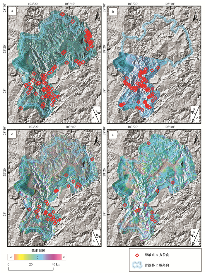
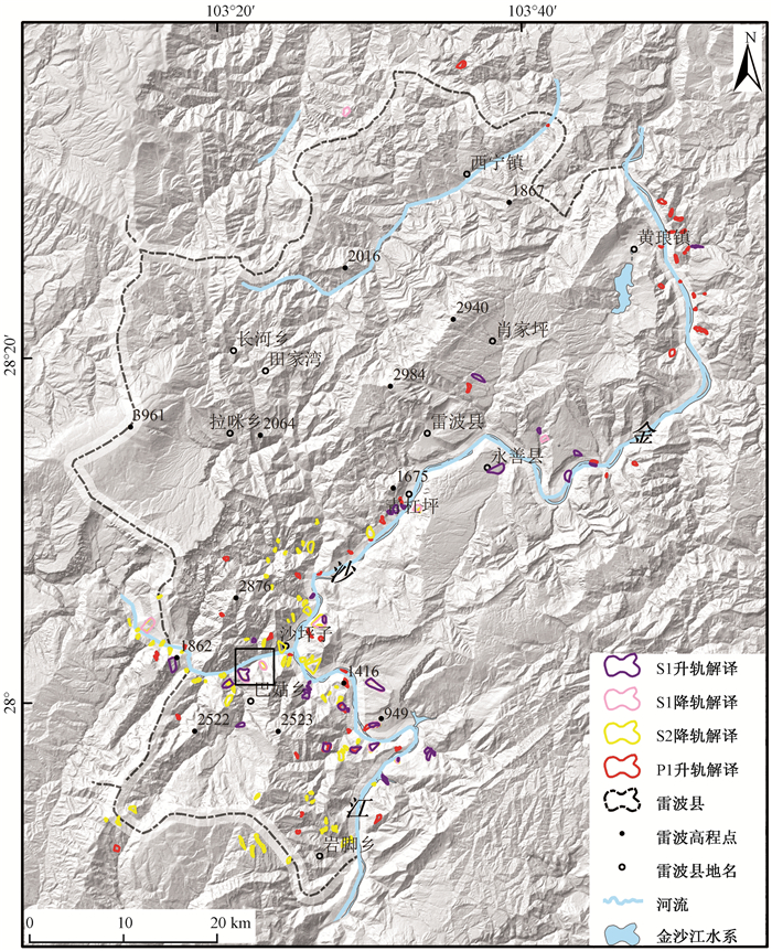
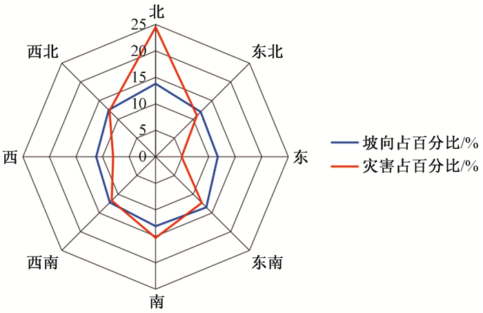
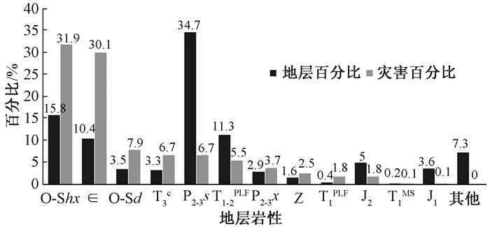
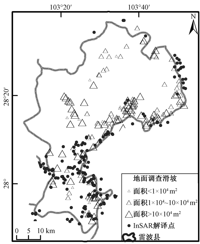
An active landslide rapid recognition method, based on InSAR deformation and assisted by optical remote sensing, geomorphologic features and geological conditions, is presented in this article and Leibo County of Sichuan Province is chosen to be the study area. Four type of SAR data, PALSAR-1/2 as-/descend and Senitnel-1A/B de-/ascend are processed, with interpretation of 163 landslides overall and analysis of spatial and temporal distribution, from which some important conclusions are drawn. (1) InSAR can trace long and small deformation so as to realize effective recognition of active landslides; (2) The use of multiple types SAR data can overcome the shortages of InSAR, such as layover, shadow, incoherence, to improve the efficiency, effect and timeliness; (3) Compared with field investigation results, landslides recognized by InSAR are more comprehensive and accurate, especially for high-position and centralized landslides, and therefore InSAR can be taken as one of the important methods for landslide survey; (4) The landslides in Leibo county mainly occurred along the Jinsha river and the Meigu river, on the north slope and slope areas with a gradient from 30° to 40°. The overall distribution of geological hazards in each stratum is even, except for the Cambrian and Ordovician-Silurian with a relatively high ratio.
NUMERICAL ANALYSIS ON DYNAMIC RESPONSE OF THE OBLIQUE METRO TUNNEL IN GROUND FISSURE AREA
LIU Lei, LIU Xueling, ZHOU Jinxi
2018, 24(2): 238-243. doi: 10.12090/j.issn.1006-6616.2018.24.02.025
Abstract (181) HTML (76) PDF (2706KB)(7)
Abstract:
A numerical analysis model, with an oblique crossing of 60°between horseshoe-shaped metro tunnel and ground fissure, was built with ABAQUS to study the dynamic response of the oblique metro tunnel in ground fissure area under vibration load of metro. The results show that the soil vibration near the tunnel is stronger, and the acceleration amplitude of the ground near the tunnel are greater than those far away from the tunnel. The area with strong vibration response is within 120 metres along the metro tunnel, 15 metres under the tunnel in vertical direction, and 20 metres in both sides of the tunnel. Ground fissure has a strong barrier effect on the propagation of subway vibration in the soil. The vibration of the soil below the ground fissure is stronger than that of the upper soil layer, and the vibration acceleration on the ground level of the soil nearly reduces to zero.
APPLICATION OF SIDE SCAN SONAR IN THE INVESTIGATION OF CRUSTAL STABILITY OF THE CROSS-SEA CHANNEL IN THE QIONGZHOU STRAIT
LI Zhen, PENG Hua, JIANG Jingjie, SUN Yao
2018, 24(2): 244-252. doi: 10.12090/j.issn.1006-6616.2018.24.02.026
Abstract (191) HTML (143) PDF (4694KB)(15)
Abstract:
For the crustal stability assessment of cross-sea channel of the Qiongzhou Strait, the Sonar Beam S-150d scan sonar system was applied to the topography investigation of the seabed in Qiongzhou Strait, in which the side scan sonar image of the engineering region was obtained. Through data analysis and image interpretation, the types of geological hazards and their potential harm were analyzed. Microgeomorphic units including soft ground, movable sand wave, bank slope and active tectonics are found on the Qiongzhou Strait seabed, which will cause relative geological disasters in the construction and operation stage of cross-sea channel engineering. All the data and analysis provide basic information for the crustal stability assessment of cross-sea channel engineering and technical support for the optimization of engineering planning and implementation. It shows that the side scan sonar technique can be applied to the investigation and assessment of the stability of the submarine crust.
EVOLUTION OF SEDIMENTARY ENVIRONMENT IN THE NORTH HETAO BASIN SINCE 344 Ka
CAI Maotang, YE Peisheng, YANG Xingchen, ZHANG Xujiao, LI Chenglu, ZHOU Wei, LU Jing, WANG Tao
2018, 24(2): 253-262. doi: 10.12090/j.issn.1006-6616.2018.24.02.027
Abstract (265) HTML (111) PDF (3434KB)(13)
Abstract:
Through analysis of sedimentary facies and grain size characteristics from 377 m drilling cores in the north Hetao Basin, combined with different dating methods, the evolution of sedimentary environment in the north Hetao Basin since late Middle Pleistocene is revealed. According to the characteristics of grain size parameters, sedimentary environment can be divided into 6 stages:lakeshore (344~326 ka)-semi-deep lake (326~165 ka)-lakeshore delta (165~130 ka) -shallow lake (130~100 ka)-lakeshore-fluvial (100~10 ka)-washland (10 ka~now). Comprehensive research shows that a unified paleo-megalake has been existed in the Hetao Basin from middle Pleistocene to late Pleistocene. After late Pleistocene, the paleo-megalake disintegrated and disappeared.
OBJECT-ORIENTED REMOTE SENSING INFORMATION EXTRACTION METHOD FOR ROCKY DESERTIFICATION IN KARST AREA-A CASE STUDY OF DAFANG COUNTY, GUIZHOU
ZHOU Di, NI Zhongyun, YANG Zhenyu
2018, 24(2): 263-273. doi: 10.12090/j.issn.1006-6616.2018.24.02.028
Abstract (160) HTML (48) PDF (4942KB)(11)
Abstract:
The existing pixel-based supervised and unsupervised classification methods can't meet the requirements of rocky desertification information extraction accuracy in karst rocky desertification area under the circumstances of complicated geological environment, large topographic relief and obvious shadows. In order to improve the accuracy of remote sensing image information extraction, texture feature data and topographic data are used to assist the object oriented method in the rocky desertification information extraction in karst rocky desertification area. Firstly, based on the characteristics of rocky desertification with uneven image sizes in TM/ETM+, the optimal segmentation parameters are calculated using texture and terrain factors to conduct multi-scale segmentation. Secondly, the grading indexes of rocky desertification are established based on vegetation coverage rates, rock exposure rates and slope factors. Finally, according to the grading rules of rocky desertification, spectral information and texture features, the information of rocky desertification in Karst area is extracted. The temporal TM/ETM+images of rocky desertification areas in DaFang, Guizhou, are selected for rocky desertification information extraction. The results show that comparing with pixel-based supervised classification and unsupervised classification methods, the object-oriented classification technology can effectively reduce the "salt and pepper phenomenon" caused by complicated topography, and the extraction accuracy is much better.
DISCUSSION ON MANGSHAN LOESS STRATIGRAPHIC DIVISON IN CHINA CENTRAL PLAINS
YANG Zhou, WANG Shubing, JIANG Fuchu, WANG Xisheng, FU Jianli
2018, 24(2): 274-282. doi: 10.12090/j.issn.1006-6616.2018.24.02.029
Abstract (280) HTML (215) PDF (5320KB)(11)
Abstract:
Stratigraphic age and stratigraphic division are basic and pilot work. As the research moves along, stratigraphic division will be re-recognized. The age and division of the loess stratigraphy mainly depend on OSL, 14C, paleomagnetism and magnetic susceptibility. Mangshan is famous for the extremely thick Manlan loess, while there exists different understandings about the stratigraphic division. Early research about Zhaoxiayu section revealed that the thickness of L1 is 98m, with the weakly developed palaeosol L1SS1, and the oldest stratum exposed at the bottom of the section is the palaeosol S10. Later, the early L1 layer was divided into L1, S1 and L2 layers, and the oldest layer at the bottom of the section is the palaeosol S11 layer. Based on detailed paleomagnetic study of B/M boundary, combined with previous dating results, it is believed that the early division of L1 and the confirmation of the oldest stratum are correct, but the position of B/M boundary is mislocated. The late-stage studies are right in the position of B/M boundary but wrong in the confirmation of the oldest stratum, and also it's not appropriate to divide the palaeosol layer L1SS1 of the Malan Loess into S1. The stratigraphic correlation shows that the Mangshan loess include S0-S10 loess-palaeosol sequence, and the B/M boundary is located at the bottom of the loess L8.
REDEFINITION OF THE SEDIMENTARY TIME OF THE SALAWUSU FORMATION IN THE HONGSIBU BASIN, NINGXIA AND ITS SIGNIFICANCE
CUI Jiawei, LI Zhenhong, LIU Feng, DONG Xiaopeng, HUANG Ting, ZHAO Yang
2018, 24(2): 283-292. doi: 10.12090/j.issn.1006-6616.2018.24.02.030
Abstract (229) HTML (107) PDF (4385KB)(9)
Abstract:
Based on the detailed field profile observation and stratigraphic correlation works, we re-divide the Late Pleistocene sedimentary cycle in the Hongsibu basin, Ningxia. What's more, we also redefine the sedimentary frame of the Pleistocene in the Hongsibu basin combining with the accurate time limit from the OSL or 14C dating results. The lacustrine deposit of the former Salawusu formation can be subdivided into the lower part which corresponds with the traditional Salawusu formation, and the upper part which corresponds with the Shuidonggou formation according to the regional stratigraphic comparison. Overall, the sedimentary process of these two parts covered two periods in which large paleo-lakes developed at the north-eastern margin of the Tibet Plateau during the Late Pleistocene. Besides that, these two periods in which large paleo-lakes developed corresponded to the marine oxygen isotope stage 3 (MIS 3) and stage 5 (MIS 5). During these two stages, the paleoclimate around the world was warm and wet, which means the evolution of the paleoclimate at the north-eastern margin of the Tibet Plateau took concerted action with the whole world. Moreover, there also exits a regional unconformity between these two sets of lacustrine deposits which means there developed a significant tectonic uplift during the sedimentation of these two large paleo-lakes. The tectonic uplift might have close relationship with the uplift of the Tibet Plateau during the Late Pleistocene. Therefore, the sedimentary time re-definition of the Salawusu formation is of great significance to the study of the formation and evolution of the Pleistocene large paleo-lakes, transition of the paleo-environment, and the tectonic uplift of the Tibet Plateau during the Late Pleistocene.
Inside Cover
2018, 24(2): 293-293.
Abstract (122) PDF (11320KB)(2)
Abstract:
Inside Cover
2018, 24(2): 294-294.
Abstract (94) PDF (16409KB)(4)
Abstract: