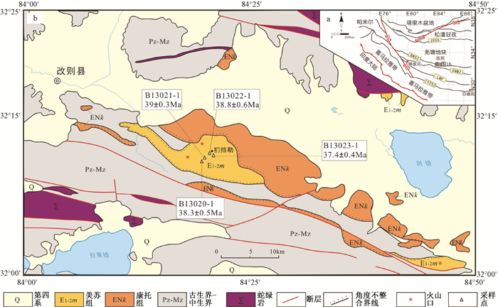
2018 Vol. 24, No. 1

Display Method:
FORMATION MECHANISM OF STEEPLY INCLINED REVERSE FAULT: TAKE THE SERIKBUYA FAULT IN TARIM BASIN AS AN EXAMPLE
LI Wei, CHEN Shuping, YUN Jinbiao, LIU Zhina, LIU Shilin, JI Hongying
2018, 24(1): 1-8. doi: 10.12090/j.issn.1006-6616.2018.24.01.001
Abstract (323) HTML (154) PDF (3025KB)(11)
Abstract:
Many steeply inclined reverse faults have developed in basins of western China, but we have not yet gained an unified understanding of their formation mechanism. The Serikbuya fault is located in the western Tarim Basin and it is a typical steeply inclined reverse fault, which provides a good example to study the formation mechanism of steeply inclined reverse fault. According to the latest seismic profiles and stratigraphic analysis, the inclination of the upper part of the Serikbuya fault is about 65°. The Serikbuya fault formed through two-staged tectonic movement. The first period ranged from Late Caledonian movement to early Hercynian movement(439~362 Ma), and the second period was during the Medium Himalayan movement(23.3~5.3 Ma). It is the multi-stage movements of the fault that formed the upper steeply inclined fault. That is, the movement of the previous gently inclined reverse fault changed the local stress field and promoted the maximum stress spindle from horizontal to tilt. Then the Coulomb fault inclination occurred steep and back thrusts appeared. At the same time, the results of digital sandbox simulation are used to confirm the above inferences.
DEFORMATION CHARACTERISTICS AND GEOCHRONOLOGICAL CONSTRAINTS OF MESOZOIC NAPPE STRUCTURE IN JINGDEZHEN AREA, NORTHEASTERN JIANGXI
HUO Hailong, ZHANG Da, CHEN Zhengle, BI Minfeng, CHEN Guohua, HE Xiaolong, LI Ning, LI Xingjian, XUE Wei, OUYANG Yongpeng
2018, 24(1): 9-24. doi: 10.12090/j.issn.1006-6616.2018.24.01.002
Abstract (265) HTML (111) PDF (7146KB)(23)
Abstract:
Jingdezhen area is located in the northeastern Jiangxi province, which belongs to the Yangzi plate, and has undergone long-term tectonic activities. According to the study of regional tectonic section, the Mesozoic thrust-nappe structure direction of the study area is from NW to SE, the upper Shuangqiaoshan group has been pushed to the top of Carboniferous-Triassic strata, and the structural styles of the thrust belt are characterized by imbricate fans and duplexes and the maximum principal compressive stress is SE-NW trend. The study of undeformed granite zircon U-Pb isotope dating shows that the U-Pb isotope age is 157~172 Ma, and the time of tectonic movement is during early Yanshanian period. The Mesozoic thrust-nappe structure produced the magmatic mineralization process in the Jingdezhen area, and the granites of Jingdezhen area may have invaded from intracontinental subduction-related transformation tectonic setting during the early Yanshanian. The nappe structure constrains the magmatic evolution and in space associated with mineralization. Then it controls the mineralization process of the deposit.
IN-SITU MEASUREMENTS IN THE SOUTHERN MARGIN OF THE ORDOS BLOCK
NIU Linlin, FENG Chengjun, ZHANG Peng, CHEN Qunce, TAN Chengxuan
2018, 24(1): 25-34. doi: 10.12090/j.issn.1006-6616.2018.24.01.003
Abstract (231) HTML (100) PDF (2798KB)(22)
Abstract:
The crustal stress distribution pattern and fault activity of the shallow crust in the southern margin of the Ordos block are studied by using the stress test data obtained from hydraulic fracturing method. The results reveal that the maximum and minimum horizontal principal stress show a good linear relationship with depth. The gradient is 0.032 and 0.021, respectively. Stress structure of SH > Sh > SV is favorable for the activity of the reverse fault and that is different from the normal fault occurred in the 1556 Huashan earthquake. The direction of the maximum horizontal principal stress is NS-NNW, which is consistent with the direction of velocity vector field. It is different from regional tectonic stress direction interpreted by other data, which may be affected by the fault activity around the Ordos block. The crustal activity in the study area is discussed by using the Mohr-Coulomb criterion and Byerlee's law under the premise that the friction coefficient is 0.6~1.0. We found that the measured points in the southern margin of Ordos block have not reached or exceeded the limit of the earth's crust rupture and there are no fault instability or earthquake and other forms of the activities, which is in a relatively stable state of crustal stress. New in-situ stress measurement data have been added to the area. The research results provide the boundary conditions for the engineering design and construction, numerical simulation of tectonic stress field in the area, which is of great significance for the study of geological hazard assessment, crustal stability and continental dynamics.
DISTRIBUTION OF SURROUNDING ROCK STRESS IN DEEP CARBONATE RESERVOIR KARST CAVE
ZHOU Hanguo, GUO Jianchun, LI Jing, PENG Chengle, WANG Chang, GAO Shuai, ZHENG Jinkai
2018, 24(1): 35-41. doi: 10.12090/j.issn.1006-6616.2018.24.01.004
Abstract (122) HTML (68) PDF (1769KB)(10)
Abstract:
The Ordovician carbonate oil pool in northern Renqiu of the Jizhong depression is taken as an example in this article. The rock mechanical parameters in the study area were calculated based on the log data of the oil field, and the typical isolated water long elliptic karst cave of the target reservoir was selected, with its surrounding rock stress and its damage zone calculated by numerical simulation and third strength theory. The results show that:1) Under the combined action of overburden pressure and lateral pressure, the stress concentration effect zone of the long elliptic karst cave surrounding rock is 9 times of the radius. 2) The surrounding rock stress of long elliptic karst cave is mainly compressive stress, mainly concentrating in the top and the bottom. 3) The filling property of karst cave has great influence on the principal stress difference and damage range of surrounding rock. For the long-elliptic karst cave, the principal stress difference and shear damage of the surrounding rock increase with the increase of filling pressure when the filling pressure is less than 0.1 MPa; while the principal stress difference and the shear damage range of the surrounding rock gradually decrease with the increase of filling pressure when the filling pressure is more than 0.1 MPa.
APPLICATION OF PRESTACK INVERSION METHOD IN THE PREDICTION OF TIGHT SANDSTONE GAS RESERVOIR
XUE Mingxi, CHEN Kaiyuan, TIAN Zehua, JIA Shuguang
2018, 24(1): 42-50. doi: 10.12090/j.issn.1006-6616.2018.24.01.005
Abstract (151) HTML (117) PDF (4036KB)(14)
Abstract:
Taking A block of eastern Ordos Basin as an example, reservoir petrophysical sensitive parameters are demonstrated though the work of petrophysical analysis which shows that the single impedance parameter can't be applied to identify the reservoir and the parameter Vp/Vs must be used for the identification. Though the analysis of seismic simulation, the seismic resolution and the seismic-response characteristics of different sand thicknesses are studied. Based on the study of seismic simulation, in order to solve the problems of tiny thickness reservoir, rapid lateral variation and reservoir recognition difficulty, the pre-stack geostatistical inversion is chosen as the research method. Comparison of the thickness of well log interpretation and reservoir inversion in 11 wells shows that pre-stack geostatistical inversion can effectively identify reservoir with thickness more than 3m. The results of inversion are considered achieving a high accuracy prediction of reservoir with a thickness average error rate of 7.5%, the average error of five blind wells is 10.2% and the new well is 1.73% which provides a strong reference for well placement.
THE FLUID INCLUSION PALEO PRESSURE CHARACTERISTICS AND GEOLOGICAL IMPLICATIONS OF GAOTAIZI TIGHT RESERVOIR IN QIJIA AREA OF SONGLIAO BASIN
SI Shanghua, ZHAO Jingzhou, MENG Qi'an, CAO Qing, WU Weitao, ZHANG Yuhang
2018, 24(1): 51-59. doi: 10.12090/j.issn.1006-6616.2018.24.01.006
Abstract (187) HTML (77) PDF (2751KB)(12)
Abstract:
PVTx thermal dynamics simulation of reservoir fluid inclusions has been applied to restore trapping pressures by inclusion component, homogenization temperature and gas liquid ratio combined with simulation software. In Gaotaizi tight reservoir in Qijia area of Songliao Basin, the hydrocarbon charging events and the paleo fluid pressure are divided by CLSM, fluorescence microscopy and micro-thermometry, through which characteristics of different events of paleo fluid pressure are distinguished. The results indicate two stages of hydrocarbon charging in Qijia Area. The first charging occurred in upper Cretaceous Nenjiang late stage(79~75 Ma), with yellow fluorescence color. The second charging occurred in upper Cretaceous Mingshui stage(79~75 Ma), with yellow-green and blue-green fluorescence color. The paleo fluid pressures of two stages respectively are 16.13~16.97 MPa and 22.14~26.13 MPa.All the research findings are of great help to deepen the understanding of hydrocarbon accumulation patterns of the exploration area.
EXPLORATION ON STRUCTURAL CHARACTERISTICS OF THE WEIHE BASIN AND ITS EVOLUTION
LIU Lin, RUI Huichao
2018, 24(1): 60-69. doi: 10.12090/j.issn.1006-6616.2018.24.01.007
Abstract (534) HTML (101) PDF (4625KB)(62)
Abstract:
The Weihe basin is the graben basin located between the Qinling orogenic belt and the Ordos basin, and there are some controversies about the formation time and basement constitutions of the Weihe basin. In recent years, natural gas types, formation mechanism, accumulation condition, resources potentiality and basin structure in the Weihe basin have been well studied, which provides considerable evidences to resolve the controversies mentioned above. According to the drilling data and the new results of geophysical and geochemical prospecting in the Weihe basin, we found that the Weihe basin covered by Cenozoic, Mesozoic-Palaeozoic complex cap rocks, and composed of two depressions, one nose structure, two bulges and two slope belts, which respectively are Gucheng depression, Xi'an depression, Jinghe nose structural, Baoji bulge, Lishan bulge, Xianyang slope belt and Fuping-Pucheng slope belt. Baoji bulge in the west, Xi'an depression and Xianyang slope belt in the central section are covered by Paleozoic strata and Mesozoic strata, respectively. The basement of Fuping-Pucheng slope belt in the northeast and Gucheng depression in the northwest are composed of Ordovician strata and Paleozoic strata, respectively. The Weihe basin and the Ordos basin display similar basement and overlying strata. The formation of Taiyao fault (ca. 1800 Ma) provides the structural condition, and the formation of syngenetic thrust faults in Weibei uplift during Caledonian movement at the end of the Ordovician marks the beginning of independent evolution of the Weihe basin. After that, Mesozoic and Cenozoic are the main sedimentation period of the basin. Combined with previous studies, basement model and evolution model of the Weihe basin are built in this article.
REGIONAL CRUSTAL STABILITY EVALUATION IN BEIJING-ZHANGJIAKOU AREA
ZHANG Shuxuan, YANG Weimin, MENG Huajun, ZHANG Xiangying, LI Huanbin
2018, 24(1): 70-77. doi: 10.12090/j.issn.1006-6616.2018.24.01.008
Abstract (260) HTML (104) PDF (2684KB)(19)
Abstract:
On the basis of field investigation and extensive collection of information, the main factors of controlling and influencing regional crustal stability and the coupling action of internal and external dynamic geology are analyzed. Active fracture, seismicity and deep geophysics are selected as the main influencing factors of regional stability. At the same time, 11 factors, including engineering rock group, topography and surface geological hazards, are selected as evaluation factors and assigned according to category. The regional crustal stability evaluation model is established by multi-factors weighted superposition analysis method. Based on the GIS platform, the regional crust stability in Beijing-Zhangjiakou area is quantitatively evaluated, in which the research region are divided into 4 grades, including stable region, substable region, subunstable region and unstable region. According to the evaluation results of regional crustal stability, relevant suggestions are put forward for the construction and operation of the Beijing-Zhangjiakou high-railway, Yun Ding Shan Ski Slope and Shi Jing Long Ski Slope, which provides the basis for territorial planning of Beijing-Zhangjiakou area.
RESEARCH ON BASIC FEATURES AND STABILITY OF LARGE AND DEEP-SEATED LOESS LANDSLIDE ON THE NORTH BANK OF THE WEIHE RIVER IN BAOJI AREA
MENG Jing, HU Qiuyun, SHI Jusong, XIN Peng, LI Bin, WANG Tao
2018, 24(1): 78-86. doi: 10.12090/j.issn.1006-6616.2018.24.01.009
Abstract (166) HTML (136) PDF (2749KB)(13)
Abstract:
The Yangjiacun large scale deep-seated loess landslide on the north bank of the Weihe River in Baoji area is taken as the research sample in this article. Field geological detailed survey, engineering geological exploration as well as high density DC resistivity geophysical exploration method were comprehensively applied to reveal the basic features and stability of the Yangjiacun landslide. The research findings indicate that:The Yangjiacun landslide is a deep-seated multiple rotational loess landslide with a general shape of circular arc characteristic sliding surface. The northern Weihe fault just passes through from the central part of the Yangjiacun landslide mass, which might control the structure features of the landslide. The deformation of the Neogene Sanmen formation clay layers serves as the main internal cause of landslide occurrence. Comprehensive evaluation results indicate that the Yangjiacun landslide mass generally is in a stable state; however, the local deformation of landslide toe should be paid attention to. The research results will provide basis for early warning and risk control of the Yangjiacun landslide.
THE INFLUENCE OF DIFFERENT NEWMARK DISPLACEMENT MODELS ON SEISMIC LANDSLIDE HAZARD ASSESSMENT: A CASE STUDY OF TIANSHUI AREA, CHINA
LIU Jiamei, WANG Tao, SHI Jusong, XIN Peng, WU Shuren
2018, 24(1): 87-95. doi: 10.12090/j.issn.1006-6616.2018.24.01.010
Abstract (251) HTML (100) PDF (3285KB)(19)
Abstract:
Recent years, the Newmark sliding-block model is one of the most wildly-used methods for assessing the stability of slopes during earthquakes; however, the influence of different Newmark displacement models on seismic landslide hazard assessments need to be investigated and quantified. Through the comparison between the displacements estimated by various Newmark displacement models in the Tianshui area, the influence of Newmark displacement models on seismic landslide hazard assessments are discussed. The results show that the overall tendency of the seismic landslide risk assessment based on different displacement prediction models is consistent; however, due to the region dependent and various function forms of these models, there is a great difference in the distribution of moderate and high seismic landslide hazard area. It suggests that a Newmark displacement prediction model considering the attenuation characteristics of ground motion and the engineering geological background of China should be established as soon as possible, which will provide support for the potential seismic landslide hazard assessment and the rapid assessment of post-earthquake landslide.
LANDSLIDE SUSCEPTIBILITY ASSESSMENT OF NEW JING-ZHANG HIGH-SPEED RAILWAY BASED ON GIS AND INFORMATION VALUE MODEL
ZHANG Xiangying, ZHANG Chunshan, MENG Huajun, WANG Peng, LI Huanbin
2018, 24(1): 96-105. doi: 10.12090/j.issn.1006-6616.2018.24.01.011
Abstract (184) HTML (89) PDF (3693KB)(14)
Abstract:
New Jing-Zhang high-speed railway is not only an important supporting transportation infrastructure for the 2022 winter Olympics in Beijing, but also an important part of the eastern section of the "eight vertical and eight horizontal" Jinglan corridor that the state plans to implement. Based on the investigation of the landslide disaster along the Jing-Zhang high-speed railway, a statistical analysis on the correlation factors affecting the development of geological disasters are made in this article. A total of 10 variables are analyzed as input variables, namely topography (height, slope and aspect), vegetation coverage ratio, engineering rock group, fault, river, rainfall, earthquake and human activity of the study area. The results of landslide susceptibility assessment based on GIS and information value model of New Jing-Zhang High-speed Rail will be divided into 5 grades:extremely high susceptible, high susceptible, moderate susceptible, low susceptible and extremely low susceptible. The results of the model preferably inosculate with the field surveying, and the results of this article can provide a valid basis for the railway construction in the future.
CHARACTERISTICS OF MATERIAL SOURCES OF GALONGQU GLACIAL DEBRIS FLOW AND THE INFLUENCE TO ZHAMO ROAD
ZHANG Jiajia, LIU Jiankang, GAO Bo, CHEN Long, LI Yuanling, ZOU Renzhou, HUANG Liang
2018, 24(1): 106-115. doi: 10.12090/j.issn.1006-6616.2018.24.01.012
Abstract (221) HTML (118) PDF (5110KB)(25)
Abstract:
Under the background of global warming, glaciers melt, ice tongues retreat, glacial debris flows tend to be more active. Zhamo road is now the only road to Motuo county. Galongqu develops typical maritime glacier debris flows in southeastern Tibet. Based on the field survey, Galongqu valley is investigated through three kinds of material sources including moraine, collapse and channel accumulation. Distribution characteristics and participating modes of material sources are also summarized. On account of material source calculation models, the quantitative volume may participate in the Galongqu debris flow is 366.28×10⁴ m3, where the moraine source is dominant. The supplying of material sources here are representative in southeastern Tibet. Galongqu glacial debris flow might bear great hazard potential to Zhamo Road along with the global warming trend.
CHRONOLOGY STUDY OF THE QUATERNARY STRATA IN YBK1 CORE IN THE NORTH WING OF THE YANGTZE RIVER DELTA
ZONG Kaihong, ZONG Wen, KANG Congxuan, LUO Ding, BAI Shibiao
2018, 24(1): 116-127. doi: 10.12090/j.issn.1006-6616.2018.24.01.013
Abstract (170) HTML (62) PDF (3087KB)(23)
Abstract:
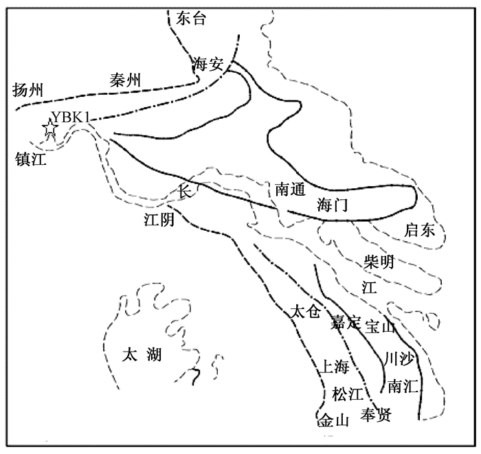
The establishment of Quaternary drilling core time rulers is an important basis for analyzing the evolution of the Quaternary environment in the plain areas. After analyzing the lithology, color, material composition, sedimentary structure and interface of the Quaternary sediments with a total thickness of 95.5m in YBK1 core in the east side of Yunhe Bridge in Shiqiao Town, Yangzhou City, dividing the stratum in detail, and using dating methods like AMS14C, OSL, cosmogenic nuclide and paleomagnetism, we finally establish the Quaternary stratigraphic-time ruler of YBK1 core. Combining with the stratigraphic structure, key bed and so on, we determine that the Quaternary sediments is overlying the Pukou group red siltstone, and it is composed of four sets of strata, which from old to new respectively are:the upper part of the early Late-Pleistocene Qidong Group, with age of 0.1~0.3Ma, thickness of 30.20m, sand bed gravel layer as the main stratum with complicated composition; the lower part of the early Late-Pleistocene Kunshan Group, with age of 0.1~0.045Ma, thickness of 1.80m, residual sand bed gravel layer as the main stratum; the middle part of the later Late-Pleistocene Gehu Group, with age of 0.045~0.01Ma, thickness of only 3.40m, littoral facies grey clay sand as the main stratum, no upper and lower parts; the Holocene Rudong Group, with large thickness of 55.10m, which can be further divided into upper, middle and lower sections with demarcation ages of~2.5Ka and~7.5Ka. The Holocene in this area is dominated by coastal sediments, estuaries and floodplains. It is the Holocene river diversion that made the stratum thickness increase suddenly. According to the lithological characteristics of YBK1 core, Early-Pleistocene and Early-Middle-Pleistocene sediments are non-existent, sediments of Late-Middle-Pleistocene to Late-Pleistocene are affected by river erosion, resulting of depositing a small amount of residual coarse grain river bed sediments. Up to Holocene, the weakening of surface hydrodynamic forces caused by river diversion produced the thicker Holocene sediments.
ZIRCON U-PB AGES OF MAGMATIC ROCKS FROM MEISU FORMATION IN GERZE AREA IN TIBET AND ITS GEOLOGICAL SIGNIFICANCE
ZHANG Yaoling, SHEN Yanxu, WU Zhenhan, ZHAO Zhen
2018, 24(1): 128-136. doi: 10.12090/j.issn.1006-6616.2018.24.01.014
Abstract (285) HTML (134) PDF (4493KB)(10)
Abstract:
The Meisu Formation exposed in Gerze basin of southern Qiangtang, middle Tibet, is composed of red sandstones and conglomerates with volcanic rock interlayers. At present, its formation age is still lack of reliable geochronologic constraints as other researchers only acquired Paleocene-Eocene K-Ar ages(34.0~69.1 Ma) from type section and other places of Meisu Formation. Laser ablation multiple collector inductively coupled plasma mass spectrometry (LA-MC-ICP-MS) method is used to determinate zircon U-Pb isotope from rhyolite, quartz trachyandesite, and granite secondary volcanic rock of sedimentary strata of Meisu Formation in Gerze basin. The results indicate that the average 206Pb/238U age of magma zircons of 3 volcanic samples and 1 intrusive rock sample are respectively 38.3±0.5 Ma, 39.0±0.3Ma, 37.4±0.4 Ma and 38.8±0.6 Ma, which defines the formation age of Meisu Formation of this area is late Eocene. The forming age of Meisu Formation of Gerze area provides chronological evidence of reactivation of Bangonghu-Nujiang Suture to regulate internal rigid block of Tibet Plateau "escape" to the East after India-Eurasia continental collision.
J. S. LEE AND A. P. KARPINSKY GOLDEN PRIZE
HAN Shuqin, YAN Chunhua, FEI Shuijing, WANG Zongxiu, CHEN Zhengle, ZHANG Kaixun, HAN Fengbin, LI Chunlin, BAKHTIER Nurtaev, ARPAY Turesebekov
2018, 24(1): 137-144. doi: 10.12090/j.issn.1006-6616.2018.24.01.015
Abstract (159) HTML (111) PDF (3979KB)(1)
Abstract:
J.S. Lee (Li Siguang)has a close contact with the geosciences field of the Soviet Union. His contributions to geology was highly appraised by the soviet Union geologists. In 1958, the general assembly of the Academy of Sciences of the Soviet Union unanimously elected J.S.Lee as the academician of the Soviet Academy of Sciences. The prestigious A. P. Karpinsky golden prize was established in the Soviet Union in 1947 to honor outstanding geologists and their academic contributions to the field of geology. From 1947 to 2017, 20 Russians and 1 Chinese have been honored with this award. The sixth recipient, J.S.Lee, was honored with this prize in 1958 as the only non-Russian. Two of his influential books have been translated into russian.The geology of China was translated in 1952 and Vortex structure of north-western China in 1958. The two translations had a great impact on the Soviet Union geological community at that time. It greatly promoted the widespread of J.S.Lee's academic thoughts. The century-old development process of geology survey in China also bears the imprint of Russian geoscience theories, norms, methods and practice, symbolizing geology without borders. Under the background of "One Belt And One Road" cooperation initiative as well as the widespread of J.S.Lee's academic thoughts, the exchanges and cooperation between China and Russia, China and central Asia in the field of geology will continue to deepen and become fruitful.
Inside Cover
2018, 24(1): 145-145.
Abstract (41) PDF (8257KB)(0)
Abstract:
Inside Cover
2018, 24(1): 146-146.
Abstract (72) PDF (11998KB)(0)
Abstract: