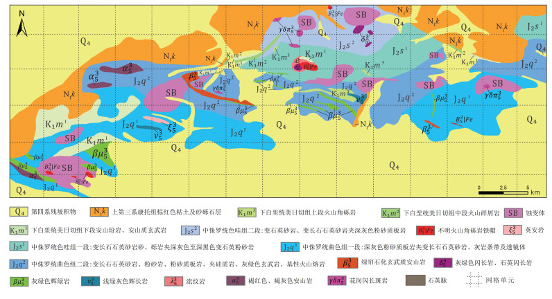
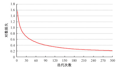
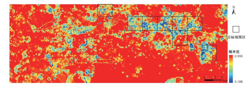
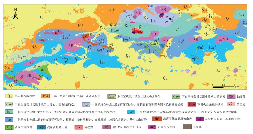
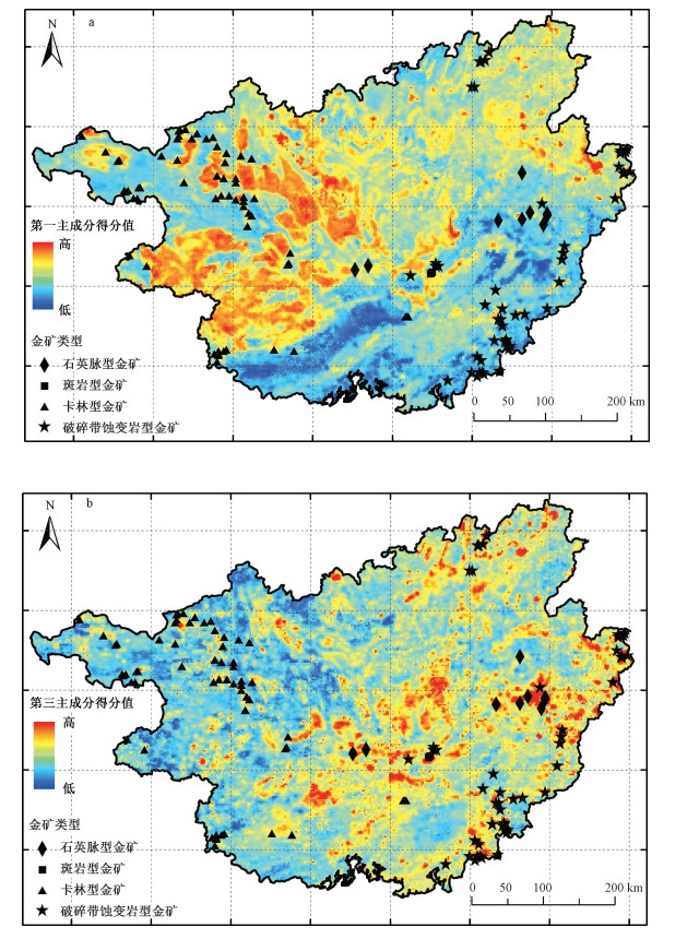
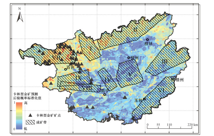
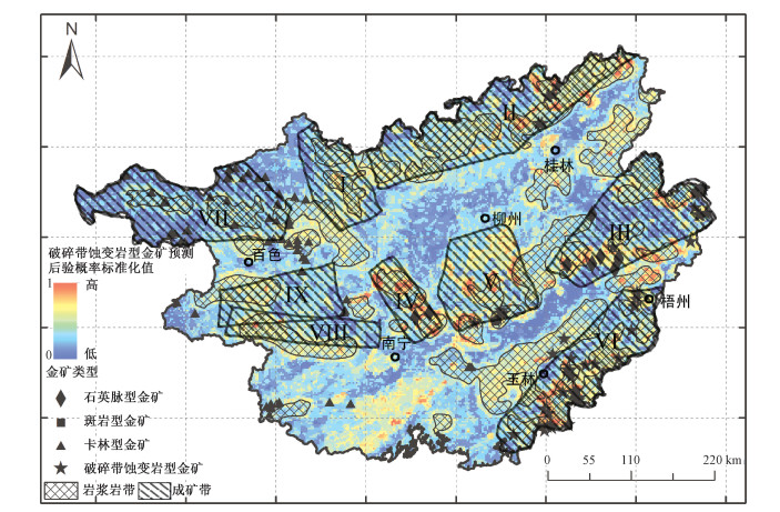
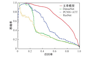
2021 Vol. 27, No. 3

Display Method:
Contents
2021, 27(3): .
Abstract (119) PDF (438KB)(13)
Abstract:
Cover Page
2021, 27(3): .
Abstract (71) PDF (1488KB)(16)
Abstract:
Chief Editor’s Address
2021, 27(3): 337-338.
Abstract (164) HTML (74) PDF (667KB)(42)
Abstract:
A machine learning-based lithologic mapping method
JI Quanwei, WANG Wenlei, LIU Zhibo, ZHU Maoqiang, YUAN Changjiang
2021, 27(3): 339-349. doi: 10.12090/j.issn.1006-6616.2021.27.03.031
Abstract (394) HTML (82) PDF (10631KB)(63)
Abstract:
In this study, a gradient boosting decision tree (GBDT)-based lithologic mapping method constituted by field survey and machine learning is introduced. The Duolong mineral district, Tibet, China is currently chosen for model test. During the practical application, geochemical data at a 1:50000 scale is analyzed to identify lithologic units, while a geological map at the same scale currently provides lithologic units identified by field survey. Lithologic units within a small area are firstly collected from the geological map. Correspondence between geochemical data and lithologic units within the small area can consequently be marked, by which the GBDT method is applied to reclassify the geochemical data and further predict lithologic units in the Duolong district. Transforming the result to a probability distribution, areas with low probability can be identified, and further investigation will be implemented to update geological knowledge and correspondence between geochemical and lithologic units. Iteration of the process will lead a reasonable lithologic mapping result. It is shown that the model accuracy increases with iteration growing, and reaches 87% after 7 iterations. The currently proposed method highlights deep integration of field survey and machine learning algorithm, and emphasizes importance of field work in the whole modeling process. Useful geo-information can be deeply mined from existing data and further updates former geological understandings. Meanwhile, lithologic units within un-explored areas can be identified based on the knowledge in explored areas. The GBDT-based method which effectively reduces field work is a meaningful exploration in lithologic mapping and will provide a new reference and supplementary way to geological mapping.
Review and prospect of structural equation modeling in geoscience data modeling and analysis
LIU Jiangtao, ZHAO Jie, WU Fafu
2021, 27(3): 350-364. doi: 10.12090/j.issn.1006-6616.2021.27.03.032
Abstract (780) HTML (99) PDF (8580KB)(45)
Abstract:
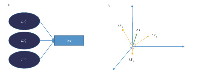
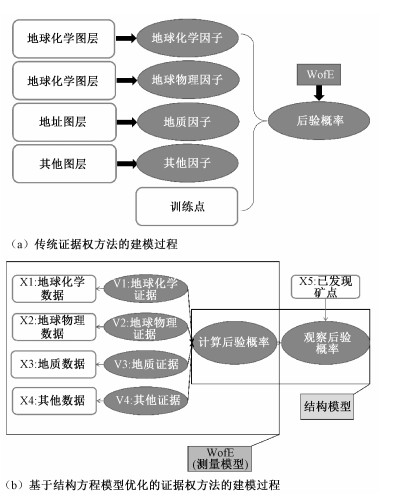
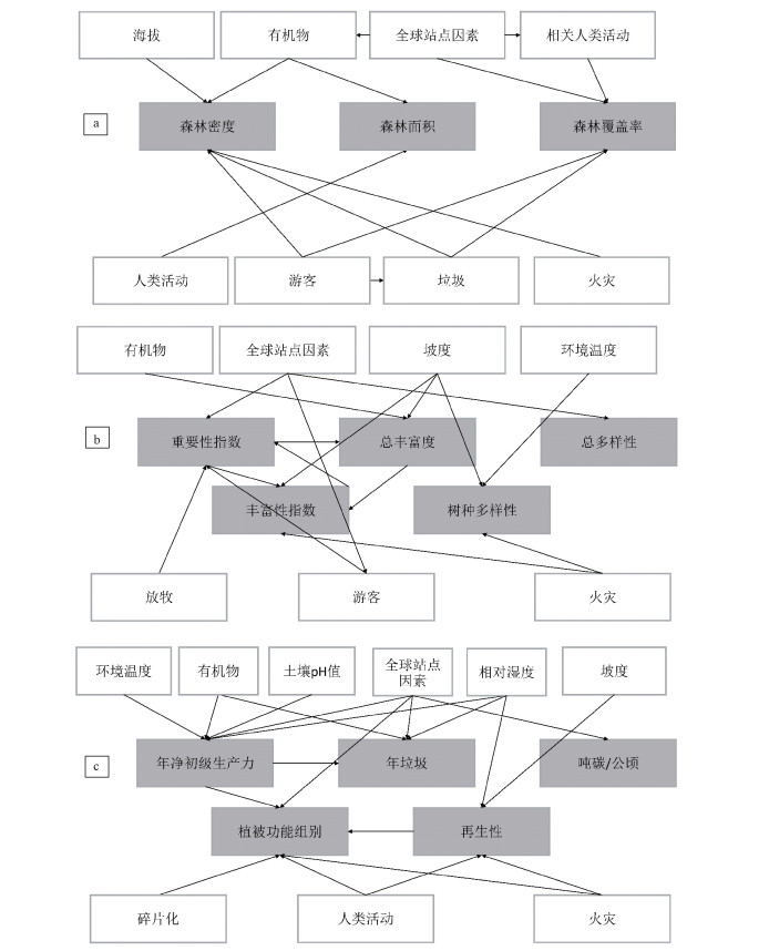
Structural equation modeling (SEM) is a method of establishing, estimating and testing causality. It can replace multiple regression, path analysis, factor analysis, covariance analysis and other methods to clearly analyze the effect of individual indicators on the overall and the relationship between individual indicators. SEM is a multivariate statistical modeling technology mainly applied to confirmatory factor analysis model. Due to the advantages of measuring latent variable scores through observable variables and analyzing the synergistic effects between latent variables using different sub-models, SEM is widely used in data modeling and analysis in the fields of psychology, behavior, and marketing. It provides a mature application path of proposing the concept-designing the model-obtaining data-verifying the model. Geoscience data modeling technology has always been one of the hotspots in geoscience research, the purpose of which is to extract valuable model structures and latent variables from massive, multi-dimensional, high-dimensional, and multi-temporal geo-data, and to study different geo-variables and interactive relationship between latent variables so as to support related applications and research such as environmental governance, disaster prevention, resource prospecting, and ecological evaluation. With the changes in the scale of geoscience data and the continuous development of modeling tools, the geoscience data modeling have gradually changed from sampling to full-sample, the method from under the guidance of geological models to unconstrained/weak-constrained modeling, the basis from variable causality to variable correlation, and the complexity from single model/single process to comprehensive multi-model/multi-process. SEM is a comprehensive modeling method, which can include multiple analysis techniques such as factor analysis, latent variable estimation, path analysis, etc. This multi-level, multi-branch modeling method combines the characteristics of knowledge-driven modeling and data-driven modeling. SEM generally faces the following three challenges, also three changes, in the modeling of geoscience data: from a method mainly oriented to confirmatory modeling and analysis to an exploratory modeling and analysis method; from a construction with complete geological model constraints to a weak model/unconstrained geological data modeling method; from a modeling of statistical variables without spatial attributes to a modeling of spatial statistical variables. This puts forward new requirements on the model itself and the method of data modeling. In response to the above three issues, this article reviews the concept and development of SEM, and introduces three application cases of SEM in geological data modeling.One is using lake sediment geochemical data to extract mineralization endogenous factors in gold mines which is modeled under weak constraints.The second is using the comprehensive parameter optimization method of SEM to weaken and correct CI problem of weight of evidence in the calculation of the posterior probability of gold prospecting by matching the posterior probability and the observation posterior probability. The third is using SEM to study the forest protection strategy of the Magdalena watershed in Mexico.By numbering the forest blocks in different regions, the spatial distribution of the data is transformed into traditional statistical variables without spatial attributes, and the impact of different environmental strategies on forest protection is analyzed.
A geology-constrained new intelligence method of synthesizing geologic bodies
XU Ke, WANG Yongzhi, CHEN Yuanyuan, CHEN Tanglei, JIANG Zuorui
2021, 27(3): 365-373. doi: 10.12090/j.issn.1006-6616.2021.27.03.033
Abstract (230) HTML (97) PDF (6622KB)(28)
Abstract:
Due to its massive content, complex processing logic and heavy repeated workload, geologic body synthesis, as the key task in the geological map compilation, is the primary factor affecting the process. Therefore, our study aims to realize the high-efficiency synthesis of geologic bodies. This paper presents a new intelligence method of synthesizing geologic bodies, which takes geological constraints (expert knowledge) as the core and cartographic generalization as the means to merge spatial graphs. Also three ways of synthesizing geologic bodies were designed (merging geologic bodies with the same properties, merging interactively selected geologic bodies, merging geologic bodies into drawn bigger polygons) based on regular mapping of geological expert knowledge such as geological age, stratigraphic name. By using the geological map data in the Beishan area to test the geologic body merging module, and through repeated comparative experiments, it is proved that this intelligence method can not only rapidly realize the "one-click" synthesis of the spatial graphs of geologic bodies, but also complete the automatic mapping and assignment of geological knowledge. The comprehensive results accord with the geological rule. This method provides an effective automatic tool for simplifying geologic bodies or other surface elements to reflect the spatial distribution in a geological map.
Quantitative prediction of mineral resources in typical gold deposits in Guangxi, China using a fuzzy weights of evidence method
DENG Jun, ZHAN Mingguo, ZHOU Weijin, WU Songle, HUANG Ning, ZHANG Runqiu, XIE Shuyun
2021, 27(3): 374-390. doi: 10.12090/j.issn.1006-6616.2021.27.03.034
Abstract (509) HTML (238) PDF (64746KB)(75)
Abstract:
Quantitative prediction of mineral resources based on multi-information fusion is the leading topic of resource potential prediction, in which the deep mining of different geological background information and geochemical data is the key problem and still challenging. In this study, we analyzed the spatial distribution characteristics of main metallogenic and associated elements such as Au, Ag, Mn, Cu, Pb, Zn, Sn and Sb in 60767 geochemical samples on the platforms like ArcGIS and GeoDAS, by summerzing the geological background information and metallogenic controlling factors of each tectonic unit in Guangxi. Based on the GeoDAS paltform, through IDW interpolation, S-A anomaly decomposition, principal component analysis and other technologies, the data from the layers with geochemical component element anomaly, gravity and aeromagnetic anomaly and the buffers at the intersection of magmatic rock and fault were used as the training points for the utilization of the fuzzy weights of evidence. A posteriori probability map was drawn up to delineate the favorable metallogenic areas for Carlin-type gold deposit and fracture zone altered gold deposit. This study is of great significance to the application of new metallogenic theories and evaluation techniques in the evaluation or zoning of mineral resources potential.
Research on a geological entity relation extraction model for gold mine based on BERT
HUANG Xusheng, ZHU Yueqin, FU Lijun, LIU Yujiang, TANG Keke, LI Jin
2021, 27(3): 391-399. doi: 10.12090/j.issn.1006-6616.2021.27.03.035
Abstract (316) HTML (72) PDF (3225KB)(21)
Abstract:
Intelligent identification of entity relation is an important method and approach to improve literature mining and analysis, and knowledge extraction of gold mine. This study focuses on the core issues affecting current entity relation extraction of gold mine such as complex entity relation and less manual annotation information, and proposes a BERT (Bidirectional Encoder Representations from Transformer) remotely supervised relation extraction model. The accuracy of relation extraction is increased by optimizing and improving the modules related to geological data coding, geological classification and geological entity filtering. And the effectiveness of the model is verified by the entity relation extraction experiment of 290489 pieces of gold ore documents.
An assessment method of habitat quality in small watershed with mining area: A case study of Guobayan Mineral District in the Baoxing River Basin
XU Xiaolong, YANG Xingchen, WEI Ruilong, CHENG Xianqiong, YE Chengming, WANG Lixuan, SUI Tianbo
2021, 27(3): 400-408. doi: 10.12090/j.issn.1006-6616.2021.27.03.036
Abstract (272) HTML (100) PDF (10260KB)(20)
Abstract:
This study aims to explore the impact assessment method of geologic engineering activities on the habitat quality of small watershed. This paper utilized remote sensing technology to fetch the land-use change information of the Guobayan Mineral District, a key project in the Baoxing River Basin, and also quantitatively assess the habitat quality there by InVEST model. The assessment results show that from 2000 to 2020:In the Guobayan Mineral District, the land use types mainly changed from woodland to bare land, and the proportion of woodland area decreased by 15.11%, while that of bare land increased by 12.30%;The habitat quality index decreased from 0.9234 to 0.8618, the standard deviation increased from 0.2389 to 0.3134, and the proportion of low-grade area of habitat quality increased by 4.84%, suggesting an slight overall decrease. The proportion of areas with strong habitat degradation increased by 3.40%, and the habitat degradation index increased from 0.0113 to 0.0159, indicating a slight degradation. In conclusion, although the habitat quality of small watershed could be disturbed by human activities, the impact on the environment can be controlled at a very low level through appropriate mining methods, scientific optimization of land-use pattern and effective ecological restoration.
Temporal and spatial characteristics of landslide susceptibility in the West open-pit mining area, Fushun, China
WU Jihuan, ZHANG Chunshan, MENG Huajun, GUO Han, WU Kungang, LI Hongjia
2021, 27(3): 409-417. doi: 10.12090/j.issn.1006-6616.2021.27.03.037
Abstract (668) HTML (156) PDF (16025KB)(46)
Abstract:
In recent years landslides occurred in the Fushun West open-pit mining area compared with previous ones show obvious temporal and spatial variations in the scale, activity frequency and spatial position, followed up by changes in landslide susceptibility, which presents new challenges for future treatment. We compared susceptibility changes caused by the temporal and spatial differences using the Improved Frequency Ratio model on the selected two types of hazard-triggering factors, including human engineering activities (mainly mining engineering disturbances) and engineering geological conditions. And the results pointed to slope structure, engineering rock group and hydrogeological conditions as the influencing factors. Compared with how it was in 2010, current landslide susceptibility has decreased, and the extremely high-high prone areas have decreased by 1.294 km2 in size; however, there is still a high incidence trend in the middle area of the north side. And the spatial location of the currently high landslide-prone areas has undergone major changes. The landslide susceptibility in the northwest side of the mine shows a sharp decline, and it has also reduced slightly at 50~500 m away from the eastern boundary of the mining area, while it has increased in the middle section of the north slope, and the top of the middle and west section of the south slope. Especially, the middle section of the north slope is the most landslide-prone area. The research results provide reference basis for slope treatment and follow-up planning after mining closure.
A detection method of trace metal elements in black soil based on hyperspectral technology: Geological implications
WANG Jianhua, ZUO Ling, LI Zhizhong, MU Huayi, ZHOU Ping, YANG Jiajia, ZHAO Yingjun, QIN Kai
2021, 27(3): 418-429. doi: 10.12090/j.issn.1006-6616.2021.27.03.038
Abstract (434) HTML (69) PDF (6433KB)(30)
Abstract:
In the case of low content of heavy metals in soil, the hyperspectral characteristic response of heavy metals is very weak, so it is difficult to construct an accurate direct hyperspectral inversion model. In order to solve the above problems, according to the physical and chemical properties of soil chemical variables, the enrichment characteristics of heavy metals are transferred to the related major chemical elements, so that the weak information of heavy metals can be indirectly quantitatively inverted. In this paper, the black soil in Hailun was taken as the research object. Through principal component analysis and cluster analysis, it was confirmed that there was an obvious adsorption occurrence relationship between the major element iron oxide (Fe2O3) and trace heavy metals As, Zn, Cd. The best inversion model of iron oxide content in the study area was established by partial least square method (the determination coefficient is 0.704, the root mean square difference is 0.148, and the F-test is 12.732). Based on the occurrence relationship between iron oxide and As, Zn, CD, a nonlinear fitting model between the predicted value of iron oxide and the real value of heavy metals was constructed by neural network. The fitting results show that the fitting degree of As, Zn and Cd is As>Zn>Cd. The overall correlations are 0.796, 0.732, 0.530 respectively. The study results show that the indirect prediction model based on iron oxide content can better quantitatively predict As, Zn and Cd, which provides a new method for the quantitative analysis of trace heavy metal content. This model provides a basis for hyperspectral remote sensing technology to predict soil heavy metal content, enhances the feasibility of soil trace heavy metal inversion, and is helpful to refine the quality monitoring of natural resource. It is of great significance to deepen the comprehensive analysis and evaluation of geoscience system.
Re-analyzing the in-situ stress field in the right bank of the Baihetan hydroelectric power plant using the borehole breakout data
CHEN Nian, WANG Chenghu, CHEN Pingzhi, CHEN Jianlin, ZHOU Hao
2021, 27(3): 430-440. doi: 10.12090/j.issn.1006-6616.2021.27.03.039
Abstract (325) HTML (78) PDF (14757KB)(26)
Abstract:
The Baihetan hydroelectric power plant, located on the Jinsha River in the Sichuan-Yunnan Block, Southwest China, is the second largest after the Three Gorges hydroelectric power plant. Crustal stress state is an important geological factor affecting underground engineering, and the stability analysis of underground chamber is of great significance. For the long-term safe operation of the Baihetan hydroelectric power plant, the ultrasonic borehole televiewer with high resolution is utilized to log 7 boreholes in the right bank. The data of borehole breakouts are used to calculate the present orientation of principal stress in engineering rock masses. The results show that the orientation of the maximum horizontal principal stress (SH) in the right bank is NNE-SSW, which is mainly influenced by tectonic stress, gravitational stress, river denudation and bank slope unloading, belonging to the local tectonic stress field.
Structural preservation conditions analysis of oil and gas in complex structural area: A case study of structural analysis in the Well Wanjingdi-1, Anhui, China
TAN Yuanlong, WANG Zongxiu, FENG Xingqiang, XIAO Weifeng, JI Changjun, WU Lin, ZHOU Lei, ZHANG Linyan
2021, 27(3): 441-452. doi: 10.12090/j.issn.1006-6616.2021.27.03.040
Abstract (284) HTML (100) PDF (28545KB)(90)
Abstract:
The multi-stage tectonism of compression and extension occurred in the southern part of the Lower Yangtze region in the Mesozoic, which is one of the important factors restricting the breakthrough of oil and gas exploration in this area. This paper aims to reveal the influence of Mesozoic tectonisim on oil and gas preservation in the Lower Yangtze area. Based on the seismic profile interpretation data, field outcrop survey, regional tectonic evolution history analysis and the drilling core data and oil-gas display of the Well Wanjingdi-1, we comprehensively discussed the favorable structural preservation conditions in the southern part of the Lower Yangtze region. The results of seismic interpretation profile and surface survey show that the southern part of the lower Yangtze River has experienced two important tectonic processes since the Late Triassic. The first stage is fold deformation, thrust fault and uplift erosion caused by Indosinian compression, and the second stage is extension since the Late Cretaceous, resulting in the formation of fault basin and normal fault activity. Shale gas display was obtained from the Permian shale in the Well Wanjingdi-1, and light oil was found in the drilling of the Lower Triassic Yinkeng Formation, indicating that the southern Lower Yangtze region has good enrichment conditions and resource potential, which points out a new direction for oil and gas exploration in the region. The analysis of structural preservation conditions shows that the Well Wanjingdi-1 is located in the syncline of the fold-depression belt. The amount of uplift and denudation was small in the Indosinian period. Since the late Cretaceous, the depression has a small amplitude of extension and has good sealing and reservoir forming conditions. It is a favorable structural position for oil and gas preservation in this region. Based on the comprehensive analysis of regional structure and sedimentary basin evolution, it is considered that in the southern Lower Yangtze region, the syncline structural belt in the southern margin of the basin with small erosion amount of Triassic strata or the central zone of fault basin overlying thick Cretaceous-Cenozoic strata should be taken as the key target to search for favorable oil and gas zones.
Assessment of regional crustal stability in Shenfu New Area of Liaoning Province, China
ZHANG Chunshan, ZHANG Shuxuan, YANG Weimin, MENG Huajun, LYU Jiajin, ZHANG Tiantian, WU Jihuan, GUO Han
2021, 27(3): 453-462. doi: 10.12090/j.issn.1006-6616.2021.27.03.041
Abstract (322) HTML (71) PDF (15300KB)(35)
Abstract:
In this paper, the main factors controlling and influencing regional crustal stability as well as the coupling action of internal and external dynamic geology in Shenfu New Area were analyzed, using both previous findings and field survey results. Based on the GIS platform, the regional crustal stability assessment was carried out through the multi-factor weighted superposition analysis method. Twelve influencing factors were selected, including fault activity, seismicity, deep geophysical status, engineering rock group, topography and surface geological hazards. The regional crustal stability assessment model was established in terms of relevance and importance of the influencing factors, through which to quantitatively assess the regional crustal stability of Shenfu New Area. And the results show that Shenfu New Area is dominated by the stable and sub-stable areas covering 728.9 km2, accounting for 81.07% of the total area, which is conducive to the planning and construction in this area. Necessary engineering measures are recommended to ensure the stability of foundation and slope when underground engineering, such as the construction of the planned Metro Line 9 at a depth of 15~25 meters, passes through the unstable and sub-unstable areas. The strata in the construction section of Metro Line 9 are generally weathering zones and junction areas of oval-gravel accumulation, mud-clastic accumulation and metamorphic gneiss, situated in groundwater immersed zones or changing zones, which is hard to be provided with protection and support. It is suggested that reasonable construction scheme should be determined as soon as possible to ensure a smooth and safe construction, and precipitation and anticorrosion measures are needed.
Discussion on the correlation between active fault and geological disaster distribution in the Ganzi area, western Sichuan province, China
QIN Yulong, WU Jianliang, ZHAN Hanyu, XIONG Changli, JIA Chun, BAI Xianzhou, LI Mingze, WU Wenhui, XU Yunfeng
2021, 27(3): 463-474. doi: 10.12090/j.issn.1006-6616.2021.27.03.042
Abstract (894) HTML (302) PDF (23841KB)(65)
Abstract:
Geological disaster effect of active fault zone is a major research area in the field of engineering geology and geological disaster. Located in the west margin of the Qinghai-Tibet plateau, the Ganzi area in western Sichuan Province has underwent different geological events, which have created its unique topography, special landforms and geological phenomena. The intensive neotectonic movements in western Sichuan have caused frequent, various, and widely distributed geological disasters, threatening the safety of human life and property and damaging social life and economic development. In this study, we analyzed the correlation between active fault and spatial distribution of geological disaster sites, and summarized the rules between their spatial distributions. It is considered that active fault is one of the internal dynamic conditions causing geological disasters in the Ganzi area, and it is closely related to geological disasters in space. In average, around the main active fault, there is 0.1 site per km2 within the range of 0~1 km, 0.05 site per km2 within 1~2 km and 0.3 site per km2 within 2~5 km. Geological disaster monitoring and prevention is urgently needed along the active faults, so as to provide basis and suggestions for reducing or avoiding geological disasters.
Geochemical characteristics of the Tertiary and Quaternary eolian deposits in eastern Gansu province: Implications for provenance and weathering intensity
QI Lin, QIAO Yansong, LIU Zongxiu, WANG Yan, PENG Shasha
2021, 27(3): 475-490. doi: 10.12090/j.issn.1006-6616.2021.27.03.043
Abstract (484) HTML (104) PDF (9661KB)(44)
Abstract:
An eolian deposit section named Shaozhai, which has been developed since the Tertiary in eastern Gansu province, was analyzed for major-trace elements and Sm-Nd isotopic compositions to explore the relationship for the provenance and weathering intensity between the Tertiary red clay and Quaternary loess. The magnetostratigraphy data indicates that the basal age of the typical eolian deposits is about 5.23 Ma B.P.. We observed both similarities and obvious differences in the Tertiary red clay and Quaternary loess. Specifically, the Tertiary red clay has similar UCC-normalized major-trace element abundances and chondrite-normalized rare earth element abundances as the Quaternary loess, demonstrating that dust materials making up these sediments likely have experienced similar and numerous recycling processes prior to deposition. The Tertiary red clay has relatively high abundances of MgO, Li, Cs, Bi and low abundances of Na2O, La-Lu, Y. In comparison with the Quaternary loess, chemical weathering parameters such as Na2O/Al2O3, CIA, combined with the A-CN-K diagram suggest that the Tertiary Red clay has experienced a stronger weathering intensity. There is not much difference in the TiO2/Al2O3, SiO2/Al2O3, SiO2/TiO2, Zr/Hf, Nb/Ta, Lu/Hf, Y/Ho, Th/Nb, Hf/Nb, total rare earth elements, differentiation degree between the light and heavy rare earth element, internal differentiation degree of the light rare earth element, abnormal degree of Ce and Eu, εNd(0) of the Tertiary red clay and Quaternary loess, demonstrating a similar provenance for them. The finer grain size and stronger weathering of the Tertiary red clay may be responsible for the difference in major and trace element content for the Tertiary red clay and Quaternary loess.