2012 Vol. 18, No. 4

Display Method:
BASIN TYPES AND CHARACTERISTICS OF BASIN GROUPS IN EAST ASIA
KANG Yong-shang, SHANG Yue-nan, YUE Lai-qun, DIAO Shun, QI Xue-feng
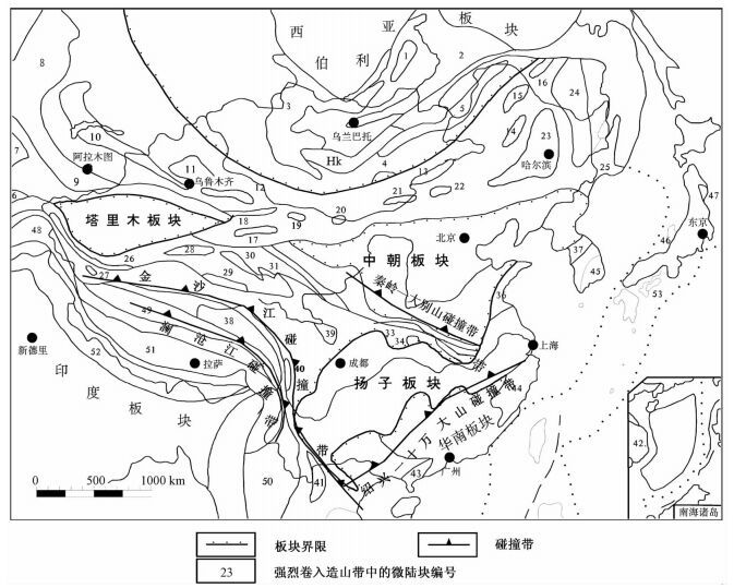
2012, 18(4): 347-358.
Abstract (185) HTML (104) PDF (2295KB)(13)
Abstract:
Tectonic evolution in East Asia was polyphased and complicated. The geological framework of East Asia basically formed during Indo-Chinese epoch. As an important tectonic evolution stage, Yanshannian epoch played a significant role in the evolution and formation process of sedimerntary basins in East Asia. In this paper, sedimentary basins in East Asia were divided into 6 types based on the three-dimensional stress (extension or compression) and the reformation degree of basins due to this stress background since Yanshannian, considering the evolution history of the basin themselves, and combined with previous research achievements on basin types. They were cratonic basin, intracontinental compaction flexture basin, strike-slip pull-apart basin, rift basin, forearc basin and back-arc basin. Basins in East Asia are further classified into two groups according to their formation periods (before or since Yanshannian epoch) and into seven groups in space according to the tectonic domains, to which one basin belongs. This classification study showed that basins in one tectonic domain were compatible relatively to such as basin type, depositional sequence, evolution history and so on, and basins in different tectonic domains displayed definite differentiation on these respects. The results of comparability or the community of the basins in the same basin group and the diversity of basins among the different basin groups, have great theoretical meaning for understanding the genesis and evolution of different basins. At the same time, this study also lays the foundation of analogy analysis for evaluation of oil and gas resource potential in the basins with lower degree of exploration.
A DEMANDING DEVELOPMENT TO HYDROCARBON RESOURCES IN CHUXIONG BASIN
LIN Zong-man
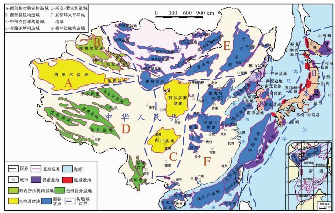
2012, 18(4): 359-378.
Abstract (512) HTML (414) PDF (4905KB)(8)
Abstract:
Mesozoic and Paleozoic marine hydrocarbon resources have been developed in South China except Sichuan Basin for half a century. The Chuxiong Basin is very important in oil and gas exploration in South China because of its material basis and favorable tectonic environment forming large-and-middle scale of hydrocarbon accumulation. Hydrocarbon source rocks mainly developed in €1, O1-2, D1-2, T3y, T3l, T3g, T3s and J1-2. Two important plays are Middle-Upper Devonian to the lower part of Upper Triassic marine formation and the upper part of Triassic land formation to Lower-Middle Jurassic. Exploration should be implemented along the margin of platform because of a bad hydrocarbon generation condition and other disadvantages as complicated structural deformation, intensive uplifting and high level of evolution inside the platform.
DEPOSITIONAL FILLING MODEL AND EVOLUTION OF THE SAG IN LACUSTRINE BASIN:A CASE STUDY FROM SHAHEJIE FORMATION IN MAXI SAG, RAOYANG DEPRESSION
ZHANG Yi-ming, LI Sheng-li, LI Min, YU Xing-he, ZHANG Wan-fu, TIAN Qian-qian, FANG Xin-xin
2012, 18(4): 379-388.
Abstract (139) HTML (101) PDF (1751KB)(5)
Abstract:
Sag is an important part of the rift lacustrine basin and is the main occurrence area of hydrocarbon source rocks. But in terms of its unique characteristics of sedimentary filling, the buried depth and the reservoir development, the exploratory degree of petroleum in a sag is usually low. Maxi sag is located at Raoyang depression, Jizhong sub-basin and this paper is to discuss the sedimentary filling model and evolution law of Shahejie Formation which is one of the main petroleum exploration intervals. The differences of sedimentary facies type and the depositional model between the steep slope and gentle slope of the sag area were delineated. Furthermore, the depositional characteristics of the Shahejie Formation, the depositional filling models of different tectonic evolution periods of the sag area were analyzed. The sag area of rift basin had the depositional conditions of the reservoir existence, and it's the favorable area for the stratigraphic reservoirs. Therefore, the sag area could be an important area for future petroleum exploration of deep strata in the rift basin.
THE WALL ROCK ALTERATION AND ITS GEOCHEMICAL CHARACTERISTICS OF THE SHAZHOU DEPOSIT IN XIANGSHAN URANIUM ORE-FIELD
CAO Xiao-bing, LÜ Gu-xian, HU Bao-qun, ZHENG Guang-gao, YAO Hong-xin, LIANG Dong
2012, 18(4): 389-400.
Abstract (179) HTML (45) PDF (2470KB)(15)
Abstract:
The ore body of Shazhou deposit in Jiangxi Province is strictly controlled by faults and its wall rock alteration zoning characteristics is very apparent. This paper introduces the geochemical characteristics of the wall rock alteration. The results of whole-rock analysis of Shazhou deposit show that the chemical composition of the ore body is very different from the surrounding rock and the differences are relevant with the migration of chemical elements in the course of alteration. The combinations of metallogenetic elements are U, W, HREE, Th, Zn, Zr, Mo, Pb based on R-mode cluster analysis of all the rock samples and these elements can serve as the criteria for U ore prospecting in the region.
CHARACTERISTICS AND SIGNIFICANCE OF THE COPPER-GOLD-ANTIMONY DEPOSITS IN DAGANGOU AREA, EAST KUNLUN
ZHANG Kai, GOU Rong-tao, LIU Shu-lin, GUO Gang, XU Jun-jie, WANG Bo-wen, LI Hua-nan, YUAN Jing
2012, 18(4): 401-409.
Abstract (140) HTML (100) PDF (2905KB)(6)
Abstract:
The East Kunlun area is located at the suture zone of Sino-Korean Plate, Tarim-Qaidam Plate, Yangtze Plate and India Plate. The special tectonic structural location decided its tectonic evolution being very complicated and distinctive. The geochemical anomalies in this area composed by Au-Co-Cu-Pb-Zn-Hg-Sb-As elements and most of them have been confirmed as anomalies related to mineral deposit. 198 ore deposits and ore spots have been found in this area. This showed a favorable ore-searching prospect. Total 6 ore deposits were discovered at Dagangou zone, including a copper multi-metal mineral belt and a gold-antimony ore-bearing structural alteration belt. Their mineralization characteristics are basically same. The ore deposit occurred in the Middle Triassic Naocangjiangou Formation west-northwest brittle-ductile shear zone and ashen-gray calcite quarts vein at the both sides of shear zone.
GENESIS OF NODULAR LIMESTONE IN THE UPPER CAMBRIAN BAOSHAN FORMATION IN WESTERN YUNNAN PROVINCE
HAO Jia-xu, PENG Cheng-long, ZHANG Guo-xiang
2012, 18(4): 410-417.
Abstract (301) HTML (189) PDF (1771KB)(11)
Abstract:
In this paper, the depositional environment and formation mechanism of the nodular limestone from the Under Cambrian Baoshan Formation in Shidian region, western Yunnan Province was discussed on the basis of mineral components, texture and structure of the node and matrix. Researches show that there are three origins of the nodular limestone in the study area. The first is that the semi-consolidate or weak-consolidate mud and carbonate sediment is altered into the nodular structure by the differential compaction and pressure solution, and the occurrence mode of the nodular limestone is determined by the content of compositions of rock and the pressure solution intensity. The second is that the semi-consolidate or weak-consolidate mud and carbonate sediment is altered into the shoestring and rudaceous nodular limestone by the slope slumping. The third is that the argillo calcareous sediment with exposure and cracking is cemented into the nodular limestone by sediment filling.
ROCK MECHANICS PARAMETER CALCULATION BASED ON CONVENTIONAL LOGGING DATA:A CASE STUDY OF UPPER PALEOZOIC IN ORDOS BASIN
GUI Rong, WAN Yong-ping
2012, 18(4): 418-424.
Abstract (313) HTML (77) PDF (1324KB)(46)
Abstract:
As the rock mechanics parameters such as Young modulus and Poisson ration are the basic data for drilling and completion as well as design for reservoir fracturing in oil field, and for simulation of tectonic stress field in sedimentary basin, it is the key contents that obtain rock mechanic parameters during petroleum exploration and development. Based on rock mechanic test and relations study between compressional wave slowness and shear wave slowness, this paper established the undetermined coefficients of the formula for shear wave slowness based on conventional logging data. The values obtained through the least square method for the three undetermined coefficients A, B and C are 2.74, 25.45, -370.16 respectively. The calculated shear wave slowness is consistent to the tested ones. Based on the calculated method, the results of Young modulus and Poisson ration of the Upper Paleozoic of Ordos Basin are range from 35593 MPa to 37997 MPa and from 0.21 to 0.25 respectively. The establishment of the formula for the rock mechanics and the study on the rock mechanical parameters laid a theoretical foundation on the research work of gas field exploration and development.
A FEASIBILITY STUDY ON TT-OSL DATING FOR THE EOLIAN SEDIMENTS FROM NORTHERN SLOPE OF KUNLUN MOUNTAINS, XINJIANG
ZHANG Ke-qi
2012, 18(4): 425-432.
Abstract (161) HTML (68) PDF (1136KB)(5)
Abstract:
The feasibility of TT-OSL dating for the eolian sediments at northern slope of Kunlun Mountains was discussed in this paper. The four samples were collected in Keriya River to Pishan County, southern Xinjiang. The measurement results showed that the intensity of TT-OSL signals were very weak, which meant a low signal-to-noise ratio resulting in the sensitive points of the corrected natural and regenerated TT-OSL signals being too scattered to fit a growth curve with high quality and reliability. Therefore a credible De will be not calculated. The paper thought that TT-OSL dating for the eolian sediments at northern slope of Kunlun Mountains, Xinjiang couldn't be reliably achieved.
ANALYSIS ON OPEN HOLE STABILITY OF A DEEP GAS WELL WITH HIGH PRESSURE DURING TESTING
CHEN Jun-hai, CHEN Mian, JIN Yan
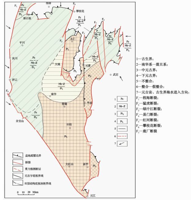
2012, 18(4): 433-439.
Abstract (115) HTML (65) PDF (712KB)(9)
Abstract:
During testing of the open hole of high pressure and deep gas well, borehole collapse may occur in open-hole sections, because borehole fluid pressure was too low to support the borehole wall. Based on stress distribution near wellbore area under non-uniform tectonic stresses, seepage stress field caused by high-pressure fluid flow through porous medium and thermal stress field due to temperature changes, and combined with the Mohr-Coulomb criterion, we can determine the well equivalent flow pressure which can prevent collapsing. In addition, it may guide density and height of fluid cushion and well control fluid, which will ensure work smoothly.
NUMERICAL SIMULATION OF LANDSLIDE MECHANISM AT ERMANSHAN IN HANYUAN UNDER DIFFERENT CONDITIONS
TAO Qian, LIU Chao, ZHU Zhi-ming, YANG Yong, ZOU Zuyin
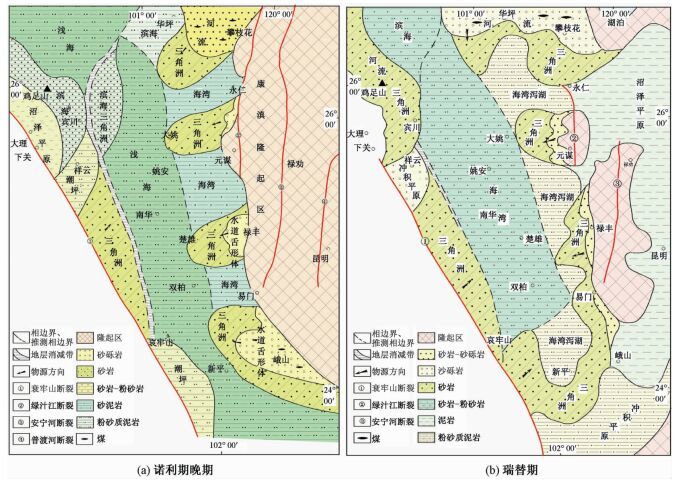
2012, 18(4): 440-450.
Abstract (172) HTML (58) PDF (2388KB)(5)
Abstract:
In this paper, the FLAC3D software was used to establish the model of Ermanshan Mountain in Hanyuan County, Ya'an City, Sichuan Province and to simulate the rainfall landslide process. The stress-strain features and slope stability were calculated and analysed in order to offer a reliable basis for the prediction of second landslide induced by earthquake and disaster prevention and reduction. Under the assumption of earthquake condition, the experiment detail analysed the dynamic characteristics of the side slope and obtained the dynamic characteristic curve of the monitoring points. Under the assumption of rainfall condition, the safety coefficient table with different strength reductions was acquired based on the stability analysis of the slope. Researches showed that the relatively special terrain conditions, geological structure and unfavourable structural surface combination were the basis of the landslide. Saturated water loading and the infiltration softening effect of a large amount of water along the oblique groove tension crack structural plane during the earlier heavy rainfall were the key factors causing landslide.
THE EFFECT OF CRD METHOD OF CIVIL AIR DEFENSE TUNNEL ON THE SURFACE
SU Zhong-jie, ZHAO Song, YANG Yu, ZHOU Xiao-ke, LIU Jing-jing
2012, 18(4): 451-456.
Abstract (138) HTML (65) PDF (1164KB)(5)
Abstract:
This paper made a preliminary study on the effect of CRD method of civil air defense tunnel on the surface based on the monitoring data, the Matlab software and the mining subsidence theory. The impacted zone was confirmed. The settlement curve's inflection point and its characteristics were found. The lower velocity zone and higher velocity zone of settlement variation were distinguished. These achievements could be referenced for the design of relevant construction and monitoring of the old tunnels.