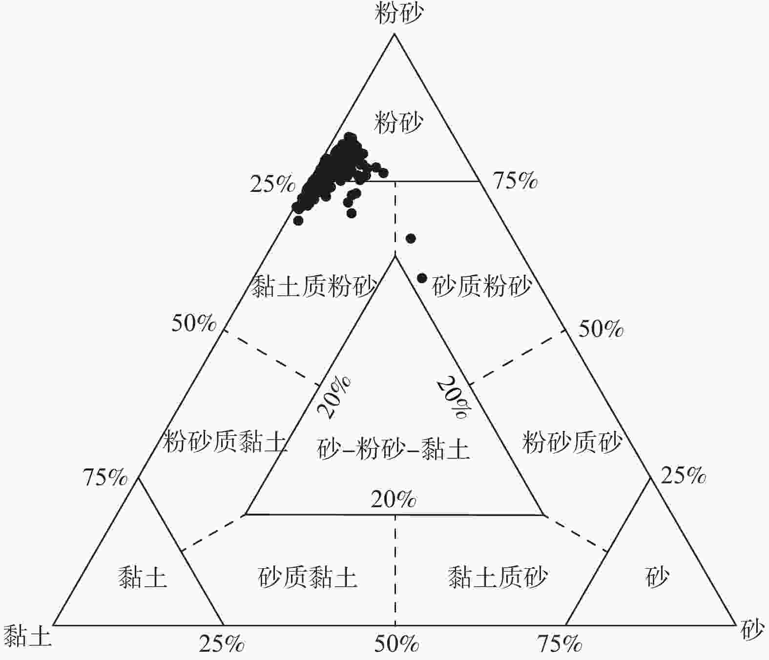
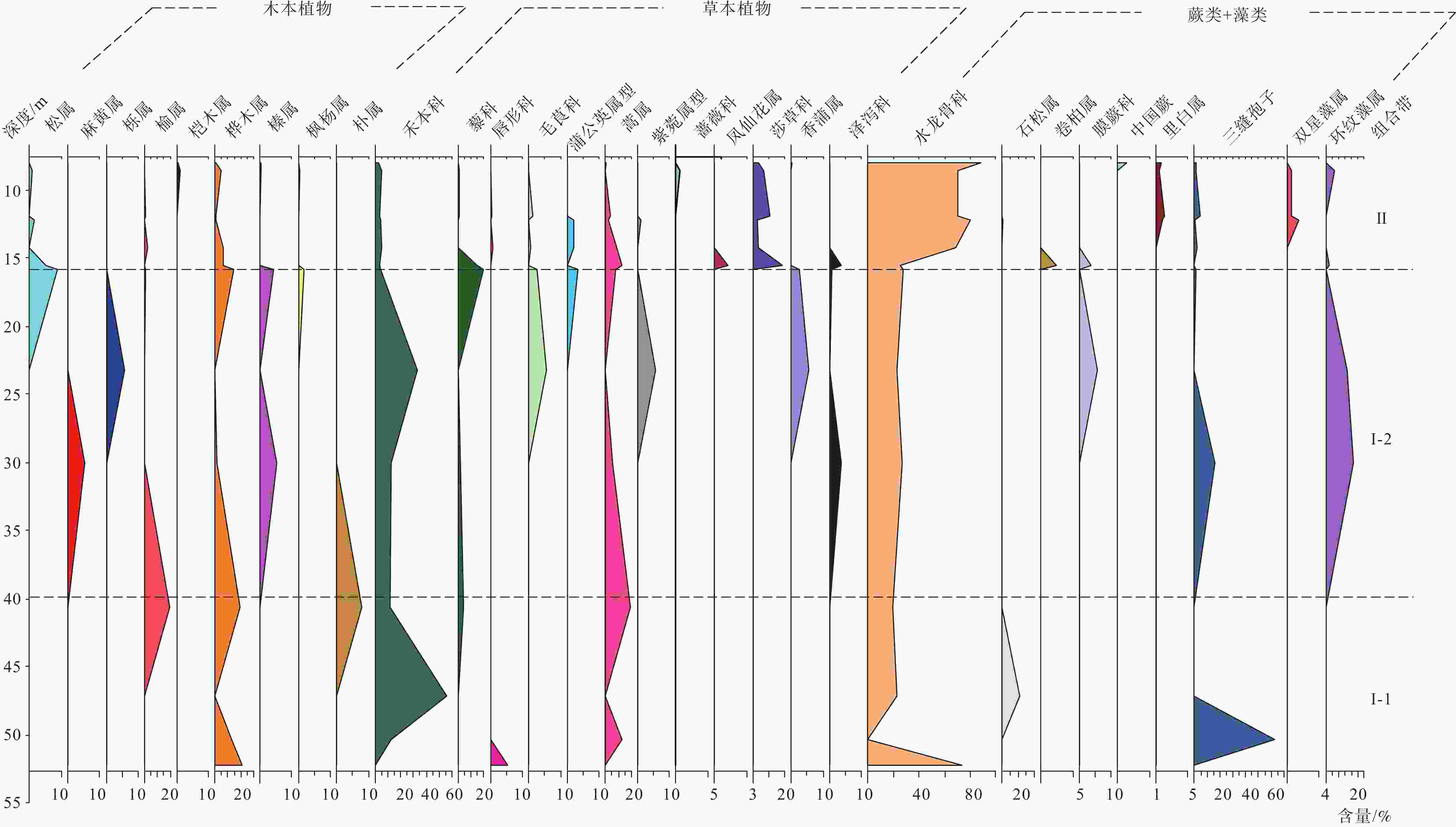
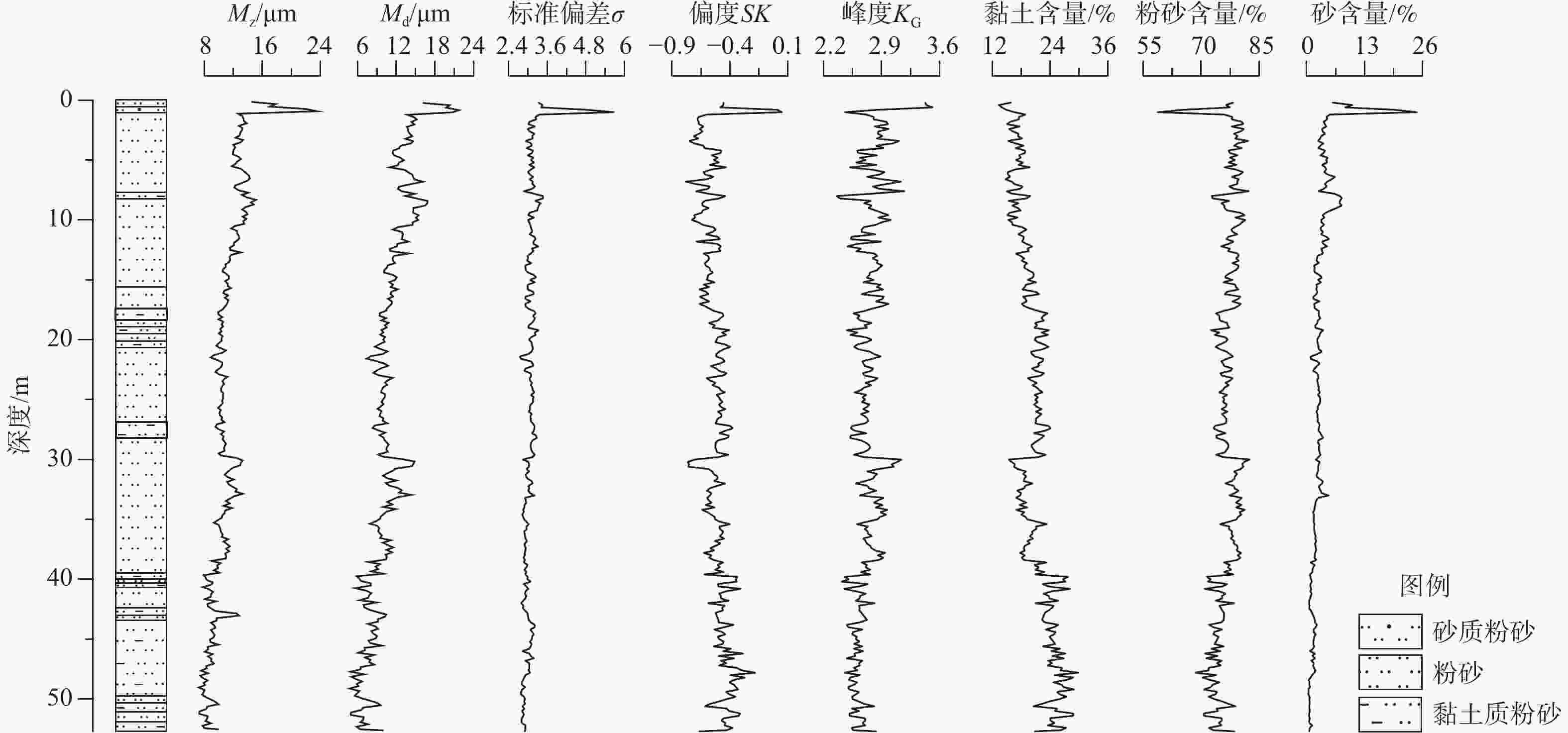
Quaternary strata lithological characteristics and environmental geological significance of borehole WKZK01 in the eastern Songnen Plain
-
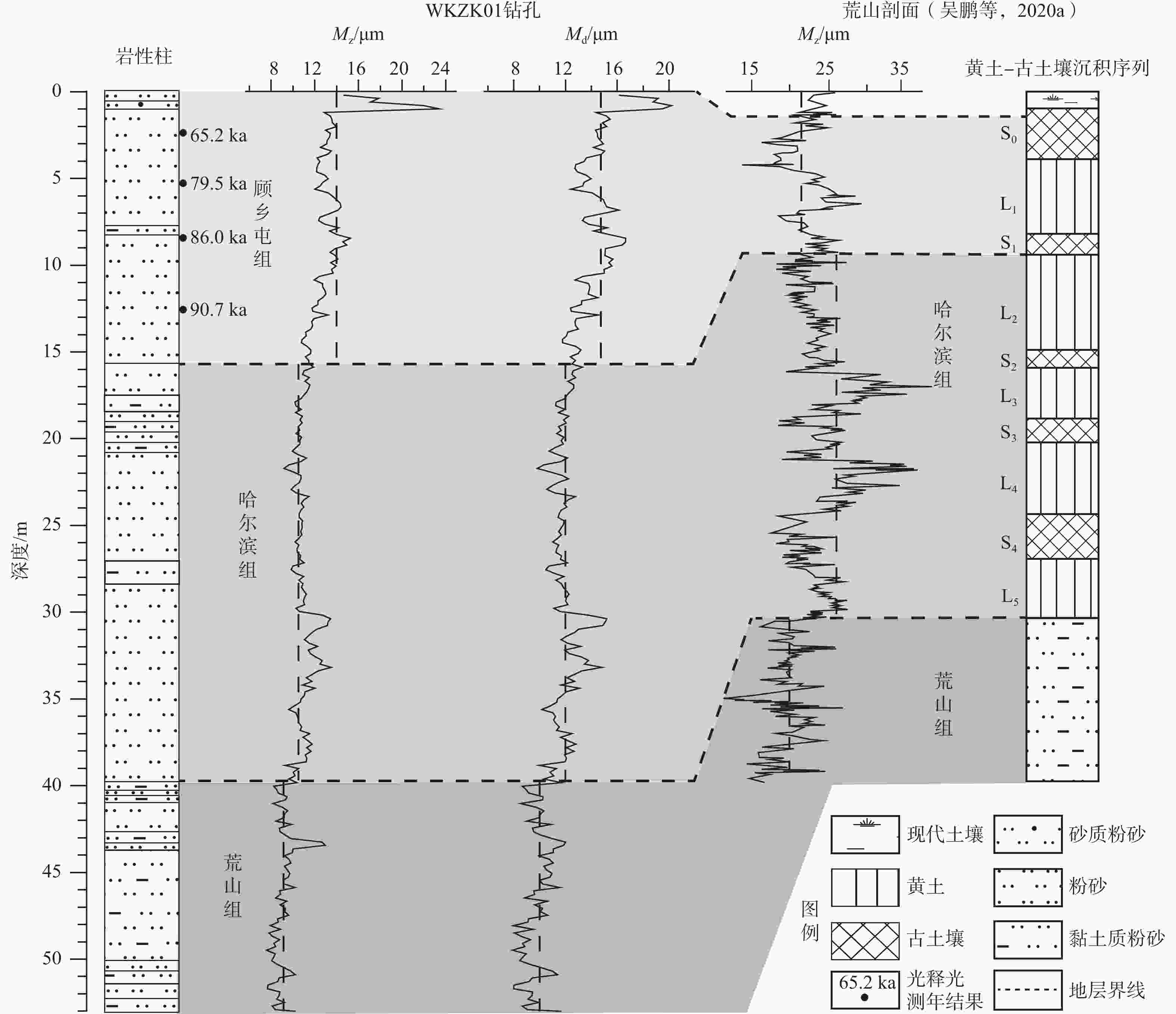
摘要: 松嫩平原东部第四纪地层特征研究对于了解区域气候变化和沉积环境演化具有重要意义。然而,目前关于该区的第四纪地层研究较少,从而限制了对该区气候环境变化机理的理解。文章选择松嫩平原东部望奎WKZK01钻孔岩芯为研究对象,在岩性特征分析的基础上,利用光释光、孢粉和粒度等测试方法,对比分析哈尔滨荒山剖面的相关成果,对钻孔第四纪地层划分及所反映的沉积环境进行了探讨。将望奎县第四纪地层由老至新划分为:中更新统荒山组、中更新统哈尔滨组、上更新统顾乡屯组,无全新统坦途组。钻孔揭露荒山组厚13.05 m,为湖泊相,孢粉带I−1记录了中更新世早期凉干气候;哈尔滨组厚24.05 m,为湖泊相,孢粉带I−2记录了中更新世晚期凉湿气候;顾乡屯组厚15.6 m,为河流相,孢粉带II记录了晚更新世冷湿气候。望奎WKZK01钻孔岩芯记录了松嫩古大湖周边面积较小的湖泊由湖心到湖滨最后消亡形成河流的环境演化过程。Abstract:
Objective Study of the Quaternary stratigraphical characteristics of the eastern Songnen Plain is of particular importance for gaining an understanding of regional climate change and the evolution of sedimentary environments. To data, however, there has been comparatively little research focusing on the Quaternary strata in this area, which has accordingly limited our comprehension of the mechanisms underlying changes in the regional climate and environment. Methods In this study we focused on the borehole WKZK01 in the eastern Songnen Plain. On the basis of lithological characteristic analysis, we obtained dating, sedimentary environment evolution, and climatic evolution information using optically stimulated luminescence, palynology, and laser grain size analytical methods, and based on comparisons with the results obtained from a typical Huangshan section, Harbin, we discuss the Quaternary stratigraphy of the borehole and the sedimentary environments it reflects. Results The Quaternary strata in Wangkui county are divided from old to new as follows: the middle Pleistocene Huangshan Formation, the middle Pleistocene Harbin Formation, and the upper Pleistocene Guxiangtun Formation, with an absence of a Holocene Tantu Formation. The Huangshan Formation is 13.05 m thick, with a median grain size (Md) ranging from 7.77 μm to 11.84 μm, and an average value of 9.62 μm. Pollen zone I-1 is dominated by xerophytic herbaceous pollen, with small amounts of mixed coniferous and broadleaf woody plant pollen, although lacks pollen derived from hydrophilic herbaceous plant. The Harbin Formation is 24.05 m thick, with a median grain size (Md) ranging from 9.67 μm to 14.98 μm, and an average value of 11.74 μm. Pollen zone I-2 is still dominated by xerophytic herbaceous pollen, with that derived from mixed coniferous and broadleaf woody plants as the secondary component, and the appearance of hydrophilic herbaceous plant pollen. The Guxiangtun Formation is 15.6 m thick, with a median grain size (Md) ranging from 11.61 μm to 19.91 μm, and an average value of 14.12 μm. Compared with the earlier stages, pollen zone II has a less abundant pollen content, although is characterized by an increase in hydrophilic herbaceous pollen, and a marked decline in the content of pollen derived from xerophytic woody and herbaceous plants. Conclusion The Huangshan Formation represents lacustrine deposits, with pollen zone I-1 providing evidence of a cool and dry climate during the early Middle Pleistocene. The Harbin Formation also comprises lacustrine deposits, with the pollen record in zone I-2 indicating a cool and humid climate during the late Middle Pleistocene. The Guxiangtun Formation comprises fluvial deposits, with pollen zone II recording a cold and wet climate during the Late Pleistocene. Significance The borehole WKZK01 provides a record of the environmental evolution of a small lake adjacent to the large Songnen paleolake, revealing a transition from the lake center to the margin and eventually disappearing with the formation of rivers. -
Key words:
- paleoenvironment /
- paleoclimate /
- optically stimulated luminescence /
- grain size /
- pollen /
- Songnen Plain
-
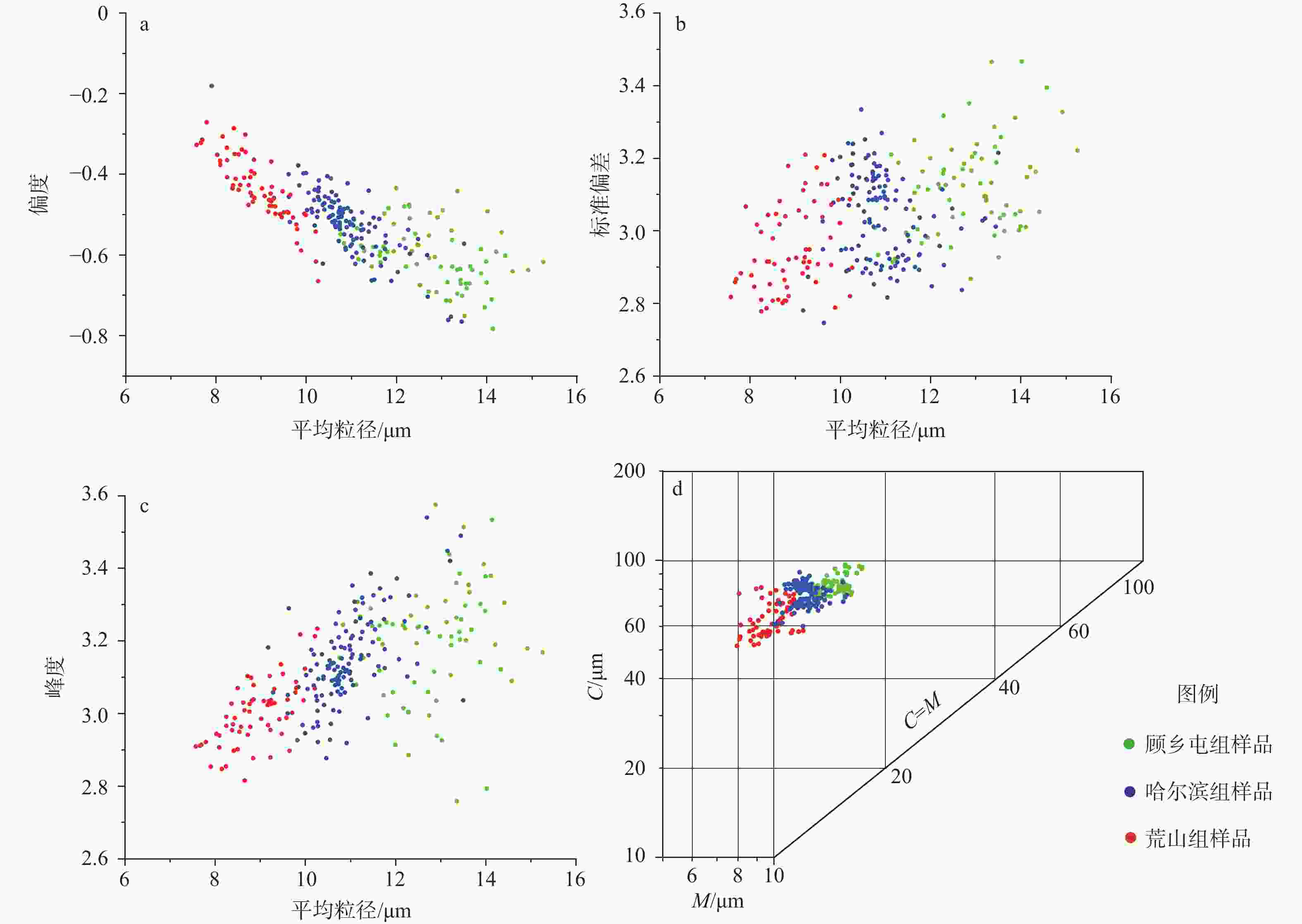
图 5 WKZK01钻孔顾乡屯组、哈尔滨组和荒山组地层样品的粒度参数散点图、C−M图
a—偏度−平均粒径散点图;b—标准偏差−平均粒径散点图;c—峰度−平均粒径散点图;d—C−M图
Figure 5. Grain size parameters of formation samples from the Guxiangtun, Harbin and Huangshan Formations in borehole WKZK01
(a) Skewness-mean scatter plot; (b) Standard deviation-mean scatter plot; (c) Kurtosis-mean scatter plot; (d) C(First percentile)-M(Median) plot
表 1 钻孔WKZK01钻孔分层及岩性特征
Table 1. Lithological and stratigraphical characteristics of borehole WKZK01
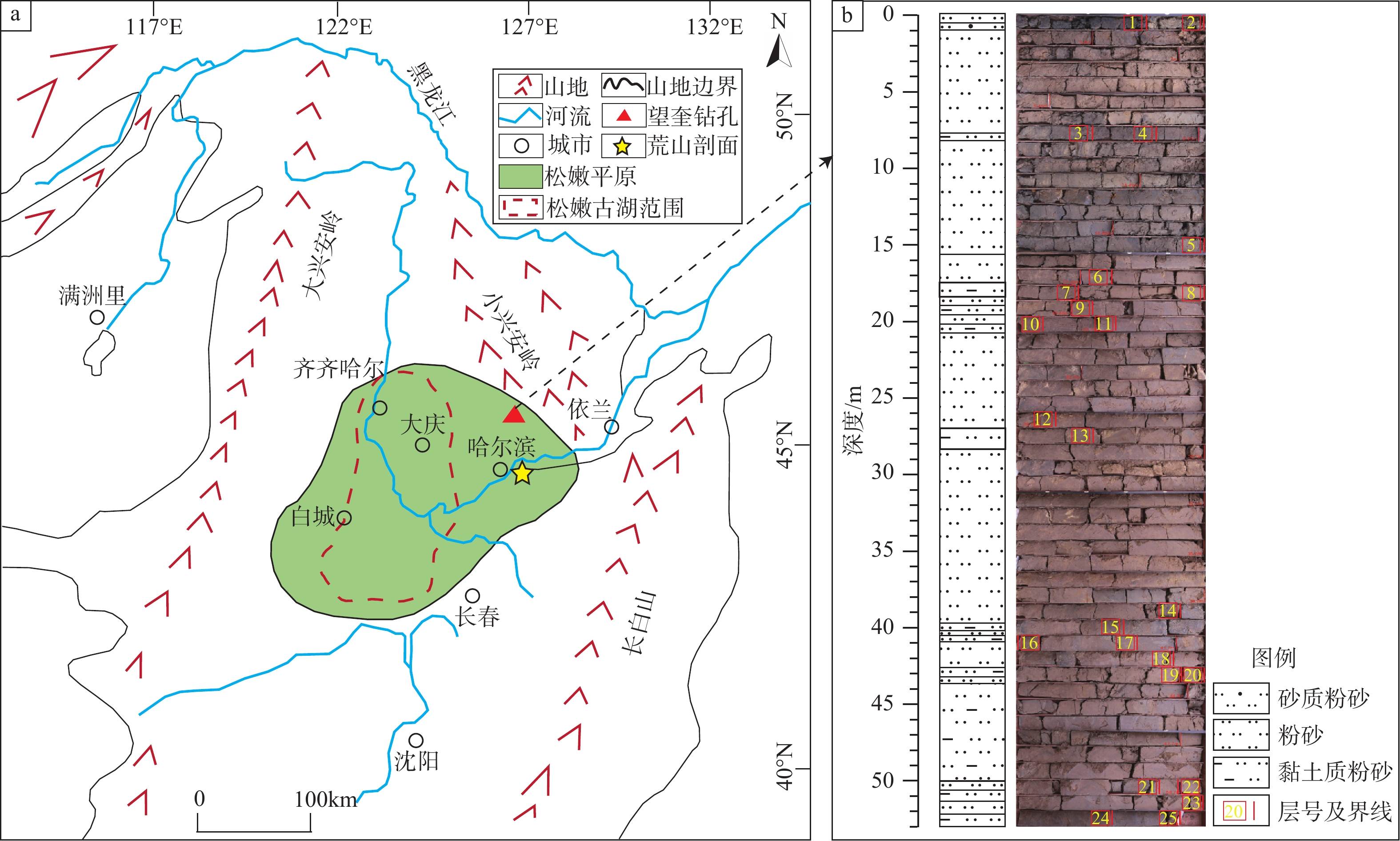
层号 层顶深度/m 层底深度/m 层厚/m 岩性特征 1 0 0.6 0.6 粉砂,棕黑色,团粒状结构,略为紧实,略为湿润,少量孔隙,少量根系 2 0.6 1.0 0.4 砂质粉砂,灰黑色,团粒状结构,略为紧实,略为湿润,少量孔隙,少量根系 3 1.0 7.8 6.8 粉砂,暗棕色,少量孔隙,少量根系,含铁染锈斑;2.7~6.5 m处为灰黄色,未见铁锰结核,颜色较为单一;6.5~7.4 m处为黄褐色;其中,6.5~6.8 m处为暗棕色,6.8~7.0处为黄褐色,含铁锰结核与锈斑,往下铁锰结核减少,颜色略带青灰色,反映氧化−还原环境 4 7.8 8.2 0.4 黏土质粉砂,棕黑色,块状结构,略为湿润,略为紧实 5 8.2 15.6 9.4 粉砂,黄褐色,少见铁锰结核与锈斑;该层从上往下颜色由深变浅。11.7~13.1 m处为棕黑色,见较多铁锰结核;该地层与上覆地层颜色界限较为清楚,可能为古土壤层;13.1~15.6 m处为暗棕色,块状结构,略为紧实,略为湿润;该地层较上覆地层颜色偏浅,但变化不明显 6 15.6 17.6 2.0 粉砂,暗棕色与棕黑色条带相间分布,块状结构,略为紧实,略为湿润 7 17.6 18.4 0.8 黏土质粉砂,黄褐色,块状结构,略为紧实,略为湿润,见少量红褐色铁结核 8 18.4 19.0 0.6 粉砂,黄褐色,见少量红褐色铁结核 9 19.0 19.6 0.6 黏土质粉砂,黄褐色,块状结构,略为紧实,略为湿润,见少量红褐色铁结核 10 19.6 20.2 0.6 粉砂,黄褐色,含黑色锰结核;该层与上覆地层区别为含较多黑色锰结核,见少量红褐色铁结核 11 20.2 20.8 0.6 黏土质粉砂,该层与上覆地层区别为含较多黑色锰结核,见少量红褐色铁结核 12 20.8 27.0 6.2 粉砂,黄褐色,含黑色锰结核;23.1~23.4 m处为棕黑色,可能为古土壤,往下颜色逐渐过渡变化 13 27.0 28.2 1.2 黏土质粉砂,黄褐色,含黑色锰结核;该层含较多黑色斑点状锰结核,见少量红褐色铁结核 14 28.2 39.6 11.4 粉砂,黄褐色,块状结构,紧实,略为湿润,含较多黑色斑点状锰结核;38.1~38.7 m处颜色偏暗,为棕黑色,发育灰白色斑点状、角砾状钙盐粉末,基质为灰黑色网纹状填充 15 39.6 40.2 0.6 黏土质粉砂,暗棕色,含黑色斑点状锰结核和红褐色铁结核,微细层理较为发育 16 40.2 40.6 0.4 粉砂,暗棕色,含黑色斑点状锰结核和红褐色铁结核,40.2~40.4 m颜色偏暗,微细层理较为发育 17 40.6 41.0 0.4 黏土质粉砂,暗棕色,含黑色斑点状锰结核和红褐色铁结核,微细层理较为发育 18 41.0 42.8 1.8 粉砂,暗棕色,含黑色斑点状锰结核和红褐色铁结核,微细层理较为发育 19 42.8 43.2 0.4 黏土质粉砂,暗棕色,含黑色斑点状锰结核和红褐色铁结核,微细层理较为发育 20 43.2 43.6 0.4 粉砂,暗棕色,含黑色斑点状锰结核和红褐色铁结核,微细层理较为发育 21 43.6 50.0 6.4 黏土质粉砂,暗棕色,含黑色斑点状锰结核和红褐色铁结核,微细层理较为发育;47.2~47.4 m处颜色偏暗,为棕黑色,发育灰白色斑点状、角砾状钙盐粉末,基质为灰黑色网纹状填充 22 50.0 50.6 0.6 粉砂,暗棕色,块状结构。含黑色斑点状锰结核和红褐色铁结核,微细层理较为发育;底部50.3~50.6 m处颜色偏暗,为棕黑色 23 50.6 51.4 0.8 黏土质粉砂,暗棕色,块状结构,含黑色斑点状锰结核和红褐色铁结核,微细层理较为发育;底部颜色偏暗,为棕黑色,发育灰白色斑点状、角砾状钙盐粉末,基质为灰黑色网纹状填充 24 51.4 52.2 0.8 粉砂,暗棕色,块状结构,含黑色斑点状锰结核和红褐色铁结核,微细层理较为发育 25 52.2 52.7 0.5 黏土质粉砂,暗棕色,含黑色斑点状锰结核和红褐色铁结核,微细层理较为发育;底部颜色偏暗,为棕黑色,发育灰白色斑点状、角砾状钙盐粉末,基质为灰黑色网纹状填充 表 2 WKZK01钻孔光释光测年样品信息及测年数据
Table 2. Sample information and dating data of optical stimulated luminescence (OSL) of borehole WKZK01
样品编号 埋深/m U/(μg/g) Th/(μg/g) K/% 等效剂量/Gy 误差/Gy 年剂量/ (Gy/ka) 含水量/% 年龄/ka WKZK01−1 2.33 1.68 8.32 1.85 183.81 7.90 2.82 24.91 65.2±2.8 WKZK01−2 5.08 1.22 7.25 1.90 199.13 6.13 2.51 28.66 79.5±2.4 WKZK01−3 8.84 1.31 7.17 1.61 215.21 9.27 2.50 17.80 86.0±3.7 WKZK01−4 12.19 1.43 6.01 1.96 236.06 12.77 2.60 22.52 90.7±4.9 -
[1] Bureau of Geology and Mineral Resoures of Heilongjiang Province, 1993. Regional geology of Heilongjiang province[M]. Beijing: Geology Press. (in Chinese) [2] Editorial Board of Chinese Vegetation, 1980. Vegetation of China[M]. Beijing: Science Press. (in Chinese) [3] FENG Z Z, 1993. Sedimentary petrology[M]. 2nd ed. Beijing: Petroleum Industry Press. (in Chinese) [4] GAO H Y, XIE Y Y, CHI Y P, et al., 2023. Sedimentary composition and detrital zircon U-Pb dating of the sand-gravel profile in Binxian County, Harbin: Indications for sedimentary environment and regional tectonic evolution[J]. Chinese Journal of Geology, 58(4): 1354-1372. (in Chinese with English abstract [5] GAO W, JIA D C, LI T L, et al., 2013. Stratigraphic boundary between Middle and Upper Pleistocene Series in Eastern Songliao Plain: age of optical luminescennce and element changes[J]. Journal of Jilin University (Earth Science Edition), 43(6): 1889-1896. (in Chinese with English abstract [6] HE H C, DING H Y, ZHANG Z K, et al., 2005. Grain-size characteristics and their environmental significance of Hongze Lake Sediments[J]. Scientia Geographica Sinica, 25(5): 590-596. (in Chinese with English abstract [7] HOU X R, XIE Y Y, KANG C G, et al., 2023. Sedimentological characteristics of the Baitushan Formation in the Eastern Foothills of the Great Xing’an Range: implications for stratigraphic divisions[J]. Acta Sedimentologica Sinica, 41(3): 720-734. (in Chinese with English abstract [8] LIN N F, TANG J, 2005. Study on the environment evolution and the analysis of causes to land salinization and desertification in Songnen Plain[J]. Quaternary Sciences, 25(4): 474-483. (in Chinese with English abstract [9] LENG Y K, XIE Y Y, KANG C G, et al., 2023. Sedimentary characteristics and environmental significance of the Juren Sandy Gravel Profile in Harbin[J]. Acta Sedimentologica Sinica, 41(2): 472-484. (in Chinese with English abstract [10] LI W Y, YAO Z J, 1990. A study on the quantitative relationship between pinus pollen in surface sample and Pinus vegetation[J]. Acta Botanica Sinica, 32(12): 943-950. (in Chinese with English abstract [11] LI X X, MAO D L, LAI F B, et al., 2024. Grain size characteristics and sand source analysis of three aeolian landforms in the lower reaches of the Qira River floodplain[J]. Arid Zone Research, 41(8): 1413-1422. (in Chinese with English abstract [12] LI Z Z, LING Z Y, CHEN X L, et al., 2010. Late holocene climate changes revealed by Grain-size cycles in takemukul desert in Yili of Xinjiang[J]. Scientia Geographica Sinica, 30(4): 613-619. (in Chinese with English abstract [13] LINK A G, 1966. Textural classification of sediments[J]. Sedimentology, 7(3): 249-254. doi: 10.1111/j.1365-3091.1966.tb01598.x [14] LIU D Y, LI W R, PENG S S, et al., 2010. Current application of grain size analysis in Chinese loess paleoclimatic study[J]. Periodical of Ocean University of China, 40(2): 79-84. (in Chinese with English abstract). [15] LIU Z R, XUE H Y, WANG C S, 2021. Late Quaternary depositional characteristics and environment significance of the Xibozhang section in Baoding, central Hebei Plain, China[J]. Journal of Geomechanics, 27(6): 1011-1023. (in Chinese with English abstract [16] MA Y F, ZHAN T, YANG Y, et al., 2021. The indication of chroma characteristics and its palaeoclimatic significance in the Tianhengshan (THS) core from the eastern part of the Northeast China Plain to the evolution of Songnen paleo-lake[J]. Acta Geologica Sinica, 95(11): 3519-3531. (in Chinese with English abstract [17] QIU S W, WANG X K, ZHANG S Q, et al., 2012. The evolution of the Large Paleolake in Songliao plain and its formation[J]. Quaternary Sciences, 32(5): 1011-1021. (in Chinese with English abstract [18] QIU S W, WANG X K, MAKHINOV A N, et al., 2014. Summary of the paleodrainage pattern changes in the Northeast China Plain and its neighboring areas[J]. Acta Geographica Sinica, 69(11): 1604-1614. (in Chinese with English abstract [19] SHEPARD F P, 1954. Nomenclature based on sand-silt-clay ratios[J]. Journal of Sedimentary Research, 24(3): 151-158. [20] SUN J H, XIE Y Y, KANG C G, et al., 2022. Stratigraphic properties of the baitushan formation in Ping’an town, the eastern foot of the Great Hinggan Mountains: an indication of provenance and sedimentary environment[J]. Journal of Stratigraphy, 46(2): 196-208. (in Chinese with English abstract [21] SUN J Z, WANG Y Z, ZHANG Q Y, 1982. Classification of Quaternary stratigraphy in Songliao Plain-Application of several chronological methods[J]. Journal of Chang'an University (Earth Science Edition)(2): 79-91, 10. (in Chinese [22] SUN Y, XIE Y Y, CHI Y P, et al., 2022. Stratigraphic characteristics of the Baitushan Formation in Longjiang county, eastern foothills of the great Xing'an Range, China: chemical weathering, sediment cycling, source-sink system and sedimentary environment[J]. Mountain Research, 40(1): 14-28. (in Chinese with English abstract [23] TIAN M Z, CHENG J, 2020. Quaternary geology and geomorphology[M]. 2nd ed. Beijing: Geology Press. (in Chinese) [24] WANG E B, 2012. Quaternary sedimentary sequences and their environmental significance in Harbin Area[D]. Changchun: Jilin University. (in Chinese with English abstract [25] WANG J X, XIE Y Y, KANG C G, et al., 2020. The indication of the heavy mineral characteristics of the core in Harbin Huangshan to the Quaternary drainage evolution of Songhua River[J]. Quaternary Sciences, 40(1): 79-94. (in Chinese with English abstract [26] WANG X Y, WU L, ZHANG G S, et al., 2008. Characteristics and environmental significance of magnetic susceptibility and grain size of lake sediments since Holocene in Chaohu Lake, Anhui Province[J]. Scientia Geographica Sinica, 28(4): 548-553. (in Chinese with English abstract [27] WANG Y, DONG J, YANG J S, 2020. Quaternary Stratigraphy of the Huangshan Section in Harbin[J]. Earth Science, 45(7): 2662-2672. (in Chinese with English abstract [28] WU P, XIE Y Y, KANG C G, et al., 2020a. The genesis of Huangshan loess in Harbin: integrated evidence from grain size, geochemistry, magnetization, sedimentation and landform[J]. Acta Geoscientica Sinica, 41(3): 420-430. (in Chinese with English abstract [29] WU P, XIE Y Y, KANG C G, et al., 2020b. The capture of the Songhua River system in the late Early Pleistocene: geochemical and sedimentological records[J]. Acta Geologica Sinica, 94(10): 3144-3160. (in Chinese with English abstract [30] WU X H, PU Q Y, QIAN F, et al., 1984. Preliminary study on the quaternary magnetostratigraphy of the Songliao plain in North-East China[J]. Marine Geology & Quaternary Geology, 4(2): 1-13. (in Chinese with English abstract [31] XIE Y Y, YUAN F, ZHAN T, et al., 2018. Geochemistry of loess deposits in northeastern China: constraint on provenance and implication for disappearance of the large Songliao palaeolake[J]. Journal of the Geological Society, 175(1): 146-162. doi: 10.1144/jgs2017-032 [32] XU Y Y, XIE Y Y, KANG C G, et al., 2022. Drainage evolution of the Songhua River system in the Early Pleistocene: evidence from TIMA minerals and geochemistry[J]. Chinese Journal of Geology, 57(1): 190-206. (in Chinese with English abstract [33] ZENG J L, CHI Y P, XIE Y Y, et al. , 2024. Stratigraphic attribute characteristics of sand and gravel accumulation of Sanjiedi Profile in Harbin, China[J/OL]. Acta Sedimentologica Sinica, 1-21[2024-11-27]. https://doi.org/10.14027/j.issn.1000-0550.2024.026. (in Chinese with English abstract [34] ZHAN T, ZENG F M, XIE Y Y, et al., 2018. Grain size characteristics of Tianhengshan core and their indications for stratigraphic division in the eastern part of the northeast plain of China[J]. Journal of Geomechanics, 24(4): 515-521. (in Chinese with English abstract [35] ZHAN T, ZENG F M, XIE Y Y, et al., 2019. Magnetostratigraphic dating of a drill core from the Northeast Plain of China: implications for the evolution of Songnen paleo-lake[J]. Chinese Science Bulletin, 64(11): 1179-1190. (in Chinese with English abstract doi: 10.1360/N972018-01212 [36] ZHANG M, XIE Y Y, KANG C G, et al., 2021. Chemical weathering characteristics of the Loess-Paleosol Sequences in Harbin Huangshan Rock Core: implication for formation environment of the Paleosol[J]. Acta Pedologica Sinica, 58(3): 673-684. (in Chinese with English abstract [37] ZHANG X, ZHENG Z, HUANG K Y, et al., 2020. Sensitivity of altitudinal vegetation in Southwest China to changes in the Indian summer monsoon during the past 68000 years[J]. Quaternary Science Reviews, 239: 106359. doi: 10.1016/j.quascirev.2020.106359 [38] ZHANG Y X, CHI Y P, XIE Y Y, et al., 2020. Organic carbon isotope composition of Harbin loess since the Mid-Pleistocene and its paleoclimatic significance[J]. Acta Geoscientica Sinica, 41(4): 525-534. (in Chinese with English abstract [39] 冯增昭,1993. 沉积岩石学[M]. 2版. 北京:石油工业出版社. [40] 高宏宇,谢远云,迟云平,等,2023. 哈尔滨宾县砂砾石剖面沉积物组成及碎屑锆石U-Pb测年:对沉积环境和区域构造演化的指示[J]. 地质科学,58(4):1354-1372. doi: 10.12017/dzkx.2023.075 [41] 高文,贾大成,李桐林,等,2013. 松嫩平原东部中、晚更新世地层界限:光释光年龄及元素变化[J]. 吉林大学学报(地球科学版),43(6):1889-1896. [42] 何华春,丁海燕,张振克,等,2005. 淮河中下游洪泽湖湖泊沉积物粒度特征及其沉积环境意义[J]. 地理科学,25(5):590-596. doi: 10.3969/j.issn.1000-0690.2005.05.013 [43] 黑龙江省地质矿产局,1993. 黑龙江省区域地质志[M]. 北京:地质出版社. [44] 侯心茹,谢远云,康春国,等,2023. 大兴安岭东麓白土山组地层的沉积学特征:对地层划分的指示[J]. 沉积学报,41(3):720-734. [45] 林年丰,汤洁,2005. 松嫩平原环境演变与土地盐碱化、荒漠化的成因分析[J]. 第四纪研究,25(4):474-483. doi: 10.3321/j.issn:1001-7410.2005.04.011 [46] 冷宇坤,谢远云,康春国,等,2023. 哈尔滨居仁砂砾石剖面沉积特征及其环境意义[J]. 沉积学报,41(2):472-484. [47] 李文漪,姚祖驹,1990. 表土中松属花粉与植物间数量关系的研究[J]. 植物学报,32(12):943-950. [48] 李鑫鑫,毛东雷,来风兵,等,2024. 策勒河下游风积地貌沉积物粒度特征及沙源分析[J]. 干旱区研究,41(8):1413-1422. [49] 李志忠,凌智永,陈秀玲,等,2010. 新疆伊犁河谷晚全新世风沙沉积粒度旋回与气候变化[J]. 地理科学,30(4):613-619. [50] 刘冬雁,李巍然,彭莎莎,等,2010. 粒度分析在中国第四纪黄土古气候研究中的应用现状[J]. 中国海洋大学学报,40(2):79-84. [51] 刘智荣,薛怀宇,王昌盛,2021. 河北平原中部保定西伯章剖面晚第四纪沉积特征及其环境意义[J]. 地质力学学报,27(6):1011-1023. doi: 10.12090/j.issn.1006-6616.2021.27.06.082 [52] 马永法,詹涛,杨业,等,2021. 东北平原东部天恒山钻孔色度变化特征与古气候意义及对松嫩古湖演化的指示[J]. 地质学报,95(11):3519-3531. doi: 10.3969/j.issn.0001-5717.2021.11.024 [53] 裘善文,王锡魁,张淑芹,等,2012. 松辽平原古大湖演变及其平原的形成[J]. 第四纪研究,32(5):1011-1021. doi: 10.3969/j.issn.1001-7410.2012.05.17 [54] 裘善文,王锡魁,MAKHINOV A N,等,2014. 中国东北平原及毗邻地区古水文网变迁研究综述[J]. 地理学报,69(11):1604-1614. doi: 10.11821/dlxb201411002 [55] 孙建华,谢远云,康春国,等,2022. 大兴安岭东麓平安镇白土山组的地层属性:对物源和沉积环境的指示[J]. 地层学杂志,46(2):196-208. [56] 孙建中,王雨灼,张庆云,1982. 松辽平原第四纪地层的划分:几种年代学方法的应用[J]. 长安大学学报(地球科学版)(2):79-91,10. [57] 孙杨,谢远云,迟云平,等,2022. 大兴安岭东麓龙江县白土山组地层特征:化学风化、沉积循环、源-汇体系和沉积环境[J]. 山地学报,40(1):14-28. doi: 10.3969/j.issn.1008-2786.2022.1.sdxb202201002 [58] 田明中,程捷,2020. 第四纪地质学与地貌学[M]. 2版. 北京:地质出版社. [59] 王恩宝,2012. 哈尔滨地区第四纪沉积序列及其环境意义[D]. 长春:吉林大学. [60] 王嘉新,谢远云,康春国,等,2020. 哈尔滨荒山岩芯重矿物特征对松花江第四纪水系演化的指示[J]. 第四纪研究,40(1):79-94. doi: 10.11928/j.issn.1001-7410.2020.01.08 [61] 王心源,吴立,张广胜,等,2008. 安徽巢湖全新世湖泊沉积物磁化率与粒度组合的变化特征及其环境意义[J]. 地理科学,28(4):548-553. doi: 10.3969/j.issn.1000-0690.2008.04.016 [62] 王永,董进,杨劲松,2020. 哈尔滨荒山剖面第四纪地层研究[J]. 地球科学,45(7):2662-2672. [63] 吴鹏,谢远云,康春国,等,2020a. 哈尔滨荒山黄土的成因:粒度、地球化学、磁化率、沉积和地貌特征的整合记录[J]. 地球学报,41(3):420-430. [64] 吴鹏,谢远云,康春国,等,2020b. 早更新世晚期松花江水系袭夺:地球化学和沉积学记录[J]. 地质学报,94(10):3144-3160. [65] 吴锡浩,浦庆余,钱方,等,1984. 松辽平原第四纪磁性地层的初步研究[J]. 海洋地质与第四纪地质,4(2):1-13. [66] 徐园园,谢远云,康春国,等,2022. 松花江早更新世水系演化:来自TIMA矿物和地球化学的证据[J]. 地质科学,57(1):190-206. doi: 10.12017/dzkx.2022.012 [67] 曾吉莉,迟云平,谢远云,等,2024. 哈尔滨三截地砂砾石堆积地层属性特征:对地层区域划分和构造的指示[J/OL]. 沉积学报,1-21[2024-11-27]. https://doi.org/10.14027/j.issn.1000-0550.2024.026. [68] 詹涛,曾方明,谢远云,等,2018. 东北平原东部天恒山钻孔的粒度特征及其对地层划分的指示[J]. 地质力学学报,24(4):515-521. doi: 10.12090/j.issn.1006-6616.2018.24.04.054 [69] 詹涛,曾方明,谢远云,等,2019. 东北平原钻孔的磁性地层定年及松嫩古湖演化[J]. 科学通报,64(11):1179-1190. [70] 张曼,谢远云,康春国,等,2021. 哈尔滨荒山岩芯黄土-古土壤的化学风化特征:对古土壤形成环境指示[J]. 土壤学报,58(3):673-684. [71] 张月馨,迟云平,谢远云,等,2020. 中更新世以来哈尔滨黄土有机碳同位素组成及其古气候意义[J]. 地球学报,41(4):525-534. doi: 10.3975/cagsb.2020.040602 [72] 中国植被编辑委员会,1980. 中国植被[M]. 北京:科学出版社. -


 下载:
下载:
