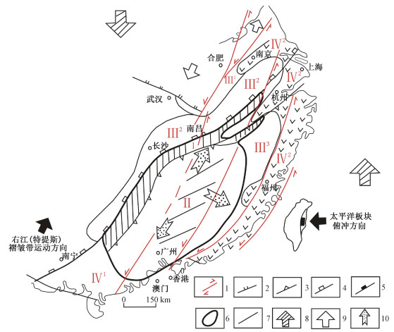
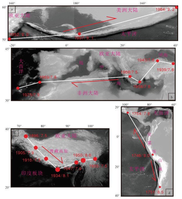
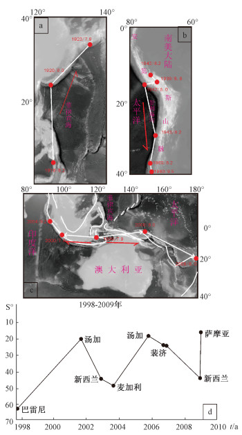
2020 Vol. 26, No. 1

Display Method:
Contents
2020, 26(1): .
Abstract (111) PDF (403KB)(7)
Abstract:
Cover Page
2020, 26(1): .
Abstract (82) PDF (1345KB)(10)
Abstract:
Inside Cover
2020, 26(1): 封二-封三.
Abstract (108) PDF (717KB)(6)
Abstract:
Core-mantle-type extensional mode and dynamic mechanism of the magmatic metallogenic explosion of the Yanshanian in the Cathaysian metallogenic province
YANG Minggui, WANG Guanghui
2020, 26(1): 1-12. doi: 10.12090/j.issn.1006-6616.2020.26.01.001
Abstract (222) HTML (155) PDF (14506KB)(40)
Abstract:
The Cathaysian metallogenic province in the southeastern China is the most important multi-metal and non-metal metallogenic province with W, Sn and precious metals along the marginal-Pacific metallogenic megaprovince. The geological investigation results and the isotopic dating data show that the magmatic metallogenic explosion caused by the intracontinental active orogeny in this region came from intracontinental crustal vulnerable zones, originally occurred in the middle section of the Qinzhou-Hangzhou juncture during the middle Jurassic period (172±Ma), intensified in the Nanling region during the Late Jurassic period, and extensively extented to outside, lastly ended in the late early Cretaceous (99±Ma), thus forming the core-mantle extended mode centred with the middle section of the Qinzhou-Hangzhou and Nanling region and the outer side as the mantle. Meanwhile, it restricted the regional magmatism, ore-forming features as well as the magmatic metallogenic regularity from early to late, core to mantle, deep to shallow and shallow to surface. The creep effection of the upper crust caused by the large-scale adjustment of the lithosphere materials and the magmatic mineralization is significant, due to the movement taking place under the sitting of the higher degree of the crustal hardenability. Therefore, the unique dynamic mechanism of the magmatic metallogenic core-mamtle-type was formed as a result of the intensive left-lateral sinistral shearing and the recombination of the weak subduction.
The types, characteristics and mechanism of seismic migration
ZHAO Genmo, WU Zhonghai, LIU Jie
2020, 26(1): 13-32. doi: 10.12090/j.issn.1006-6616.2020.26.01.002
Abstract (577) HTML (171) PDF (17759KB)(47)
Abstract:
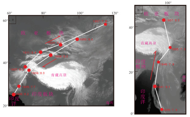
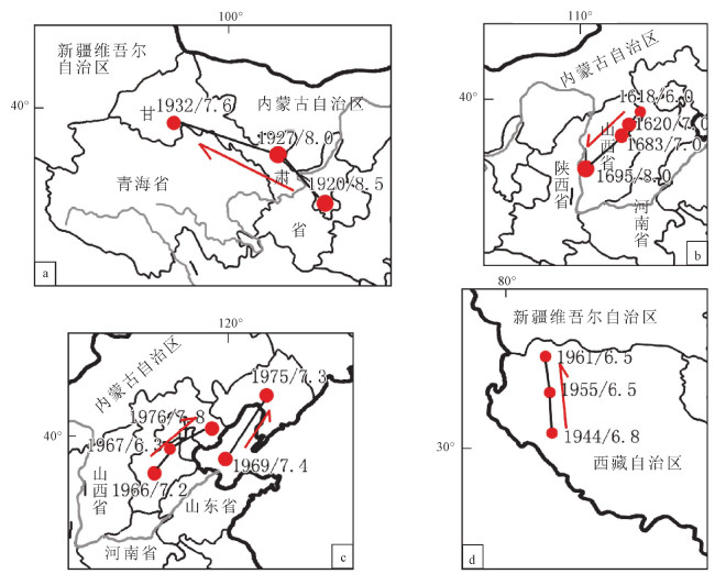
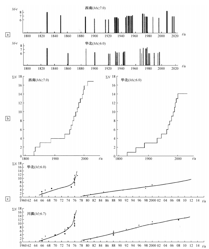
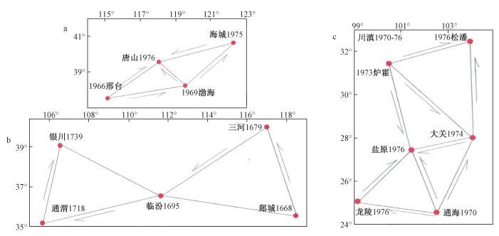
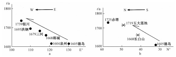
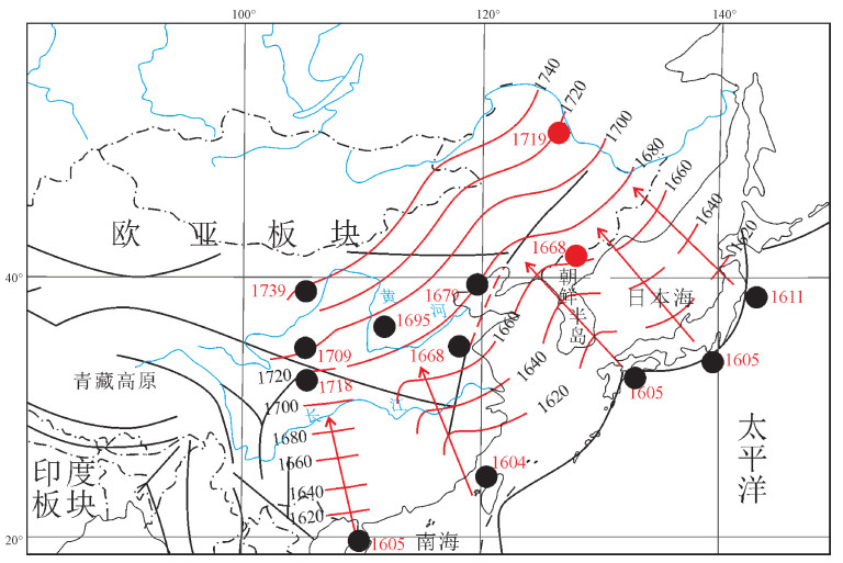
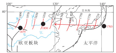
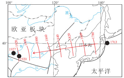
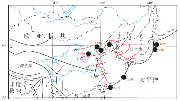
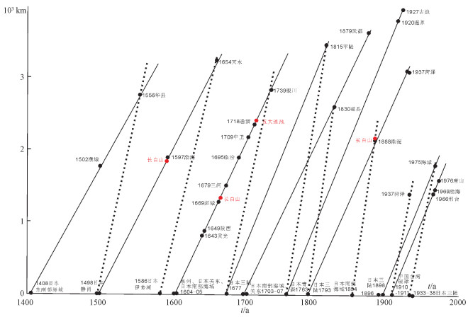
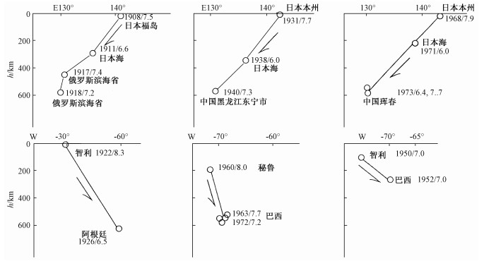
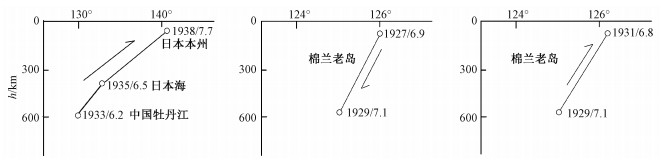
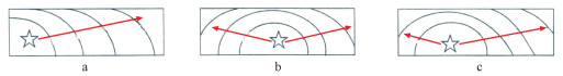
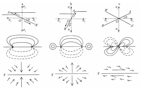
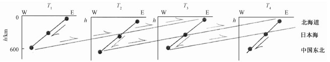
The migration of seismicity refers to the sequential occurrence of earthquakes in a certain direction, which is the ordered structure in the local area in the overall disorder of seismicity. Through the systematic analysis of the typical seismic migration phenomena in the region, it can be found that the migrations can be divided into three categories:longitudinal migration along the fault strike, transverse migration along the vertical fault strike and deep source migration on the lithosphere scale. Combined with the analysis of specific examples, the main characteristics of vertical migration (including one-way, two-way, repeated and jumping migration), horizontal migration and deep source earthquake migration can be preliminarily summarized, and the velocity values of different types of migrations can be preliminarily estimated, among which the average velocity of vertical migration along the global plate boundary is about 569 km/a, the average velocity along the sub plate boundary is about 120 km/a, and the average velocity along the continental internal fault zone is about 34 km/a. The horizontal migration is relatively complex. It is found that there are two kinds of migration phenomena in East Asia, one is about 20 km/a, the other is about 50 km/a. The global average migration velocity of deep source earthquakes is about 360 km/a. There are different levels and grades of vertical and horizontal migration of earthquakes, and there are also many kinds of deformation waves and migration phenomena with different frequencies, energy and velocities, which may be the result of the interaction of interruption layers in the process of large earthquake clustering activity, the triggering of seismic stress and the propagation of deformation waves on the scale of lithosphere, and it is obvious that the existence and regularity of this kind of earthquake migration phenomenon on the scale of large space can provide new ideas and method reference for regional seismic risk analysis.
Analysis on the application prospect of ASR in-situ stress measurement method in underground mine
SUN Dongsheng, CHEN Qunce, ZHANG Yanqing
2020, 26(1): 33-38. doi: 10.12090/j.issn.1006-6616.2020.26.01.003
Abstract (275) HTML (82) PDF (3850KB)(20)
Abstract:
Present in-situ stress state is an important data for the underground construction, tunnel stability analysis and rock burst (coal and gas burst) prediction in underground mine. At present, in-situ stress measurement in underground mine is mainly based on hollow inclusion gauge method. In practice, it is found that the stress meter of hollow inclusion gauge often fails to fully adhere to the borehole wall, which brings the low success rate and high labor intensity. In this paper, the anelastic strain recovery (ASR in short) in-situ stress measurement method based on the oriented cores is introduced. The effectiveness of ASR method are analyzed by comparing the test results with that obtained through the hydraulic fracturing method. The reliability of the ASR method is also analyzed by the repeatable test results. The results show that the maximum value of mean deviation parameter is 6.29%. The ASR method will have broad application prospects on in-situ stress measurement in underground mine with the advantages of safety, high efficiency and immunity to the limitation of depth and measurement environment.
Width of stress disturbed zone near fault and its influencing factors
WENG Jianqiao, ZENG Lianbo, LYU Wenya, LIU Qi, ZU Kewei
2020, 26(1): 39-47. doi: 10.12090/j.issn.1006-6616.2020.26.01.004
Abstract (528) HTML (83) PDF (3232KB)(72)
Abstract:
3D normal fault models in a triaxial crustal stress state were established in finite element simulation software to study the characteristics of in-situ stress in the fault developed areas. Simulated data show that the disturbed zones of in-situ stress widely exist in the surrounding rocks due to the fault movement. The principle stress direction in the disturbed zones is obviously deviated from the background stress state. The stress value is lower near the middle of the faults, while the fault ends are the abnormally high stress realm. Based on the analysis results, the distribution of stress disturbed zone is mainly decided by the fault scale. Width of stress disturbed zone proportionally goes up as fault length and displacement increase simultaneously. Rock mechanism, fault strike, shape of fault plane and background stress state affect the width of stress disturbed zone by changing the ratio of width to fault length (W-L). More intensely fractured fault rock along with higher angle between fault strike and background maximum horizontal principle stress direction, greater ratio of fault displacement to fault length (D-L), larger differential stress, leads to higher W/L value. The conclusions are verified in BZ-X Oilfield, Bohai Bay Basin. Building a 3D geologic model on the basis of actual structure relief and regional stress state, the in-situ stress in 2nd member of Shahejie Formation was calculated with the finite element method. The distribution of stress disturbed zones near faults is made clear by analyzing variation of in-situ stress state in surrounding rocks. The width of stress disturbed zones changes regularly as predicted in the law above. Both stress value and orientation, is notably changed in disturbed zones, which could affect artificial fracture propagation and well pattern deployment significantly.
Tectonic stress field research on the Ordovician reservoirs in the Tahe Oilfield
LIU Jiageng, LI Jing, SU Yuliang, FAN Zuosong, LIU Xuliang, GUO Hao
2020, 26(1): 48-54. doi: 10.12090/j.issn.1006-6616.2020.26.01.005
Abstract (257) HTML (69) PDF (8969KB)(27)
Abstract:
The distribution characteristics of tectonic stress field in carbonate reservoir are of great significance to the study on oil and gas migration law, reasonable arrangement of injection-production pattern, reservoir transformation, etc. In this paper, starting with the geological tectonic evolution of the Well Block AD13 in the Tahe Oilfield, based on the well logging data, combined with elasticity and finite element theory, the elastic mechanics computational model of crustal stress in the research area is established and the reservoir crustal stress in the research area is simulated by using the finite element software, then the calculated results are compared with the measured values of crustal stress. The results indicate that the maximum horizontal principal stress is 102~130 MPa, the minimum horizontal principal stress is 87~110 MPa, all expressing as compressive stress. The direction of maximum horizontal principal stress in the east and south, northwest, and southwest of the research area are NE, NEE and SE, respectively. The magnitude and direction of crustal stress are consistent with the actual results. The research results can provide a scientific basis for oil and gas exploration and development engineering in the research area.
Investigation on fracture propagation in fractured-cavity reservoirs based on FEMM-fracflow modelling
WANG Hui, LIU Quansheng
2020, 26(1): 55-64. doi: 10.12090/j.issn.1006-6616.2020.26.01.006
Abstract (238) HTML (78) PDF (4916KB)(14)
Abstract:
The propagation path of hydraulic fractures is critical to oil recovery in fractured-cavity reservoirs. Based on Hybrid Finite-element and Mesh-free Method-Fracflow (FEMM-Fracflow) numerical simulation platform, this paper explores the influence of natural caves, in-situ stress and injection velocity on the propagation path of hydraulic fractures in reservoirs. The simulation results show that when there are caves, the fracture propagates toward the cave. When the horizontal confining pressure is changed, the fracture propagates toward the cave obviously without applying horizontal confining pressure, and eventually connects with the cave; when the horizontal confining pressure of 50 MPa is applied, the trend of hydraulic fracture propagating toward the cave is obviously weakened; when injection velocity is changed, the fracture propagates toward the cave with the injection velocity of 0.05 kg/s, while the tendency of fracture propagating toward the cave is weakened with the injection velocity of 0.2 kg/s.
Fluid potential characteristics of Carboniferous and the division of hydrocarbon migration and accumulation units in the eastern depression of the Bayanhaote Basin
XUE Mingwang, ZHANG Tan, DING Wenlong, JIAO Baocheng, ZHOU Zhicheng, DU Xiaoyu
2020, 26(1): 65-73. doi: 10.12090/j.issn.1006-6616.2020.26.01.007
Abstract (198) HTML (105) PDF (6231KB)(14)
Abstract:
The Bayanhaote Basin is the focus of hydrocarbon exploration, but its fluid potential characteristics and hydrocarbon migration and accumulation units have not been studied, which limits the optimization of regional hydrocarbon accumulation research and exploration objectives. This paper discusses the fluid potential characteristics of Carboniferous and the division of hydrocarbon migration and accumulation units in the eastern depression of the Bayanhaote Basin. From the perspective of hydrocarbon transportation dynamics, this paper analyzes the hydrocarbon migration and accumulation laws and causes in the eastern depression of the Bayanhaote Basin. Based on the tectonic activity evolution of the basin during the main accumulation period, combined with the tectonic pattern of the period, the Late Cretaceous fluid potentials in the eastern depression of the Bayanhaote Basin were calculated, and the hydrocarbon migration and accumulation characteristics were identified by the fluid potential fields. The results show that the fluid potential field generally decreases from the east and the south to the west and southeast of the depression. The high-potential area has a small range, and the main body is located in the east and south of the depression. On this basis, it can be divided into three areas and eight units for hydrocarbon migration and accumulation. The above-mentioned fluid potential characteristics are conducive to the long-term migration and accumulation of hydrocarbon. The better hydrocarbon migration and accumulation unit is the main potential area for exploration in the eastern depression of the Bayanhaote Basin.
Stress field simulation and fracture development prediction of the Wufeng Formation-Longmaxi Formation in the Fushun-Yongchuan Block, Sichuan Basin
REN Haolin, LIU Chenglin, LIU Wenping, YANG Xiya, LI Wenyan
2020, 26(1): 74-83. doi: 10.12090/j.issn.1006-6616.2020.26.01.008
Abstract (336) HTML (114) PDF (7168KB)(46)
Abstract:
The tectonic fractures in rocks are mainly controlled by the regional tectonic stress field where the strata are located. Tectonic stress plays an important role in the migration, accumulation and distribution of oil and gas. The stress field of the Wufeng Formation-Longmaxi Formation in the Fushun-Yongchuan Block of the Sichuan Basin was simulated and analyzed by ANSYS finite element software; The three-point method in the method of structural curvature method was used to predict the development of cracks in the shale, and the comprehensive simulation results and curvature calculation data were used to predict the fracture intensity in the target area. The results proved that the distribution of the high stress value of the Wufeng Formation-Longmaxi Formation in the Fushun-Yongchuan Block is along the anticline, and the anticline stress values in the eastern and southwestern part of the study area are higher than those in other areas; the distribution of high curvature is along the anticline, and the curvature values of the anticline in the east and southwest of the study area are higher than those in other areas; the fracture in the anticline of the study area has a higher level of development, and it's lower in the syncline, at the same time it's higher in the anticline of the eastern and southwestern part of the study area than other areas under the current stress.
Application of basin simulation technology on the assessment of hydrocarbon resources potential of the Lunpola Basin in Tibet
WANG Rui, WU Xinhe, XIA Xianghua, LI Yinglie, CAO jie
2020, 26(1): 84-95. doi: 10.12090/j.issn.1006-6616.2020.26.01.009
Abstract (321) HTML (53) PDF (21335KB)(15)
Abstract:
The Lunpola Basin is the only petroliferous basin in Tibet that has obtained industrial oil flows. Due to the complicated geologic conditions and the oil is relatively thick, the progress of its oil-gas exploration is slow. In order to analyze the potentiality of hydrocarbon resources and effectively guide the oil exploration in the future, the basin simulation technology was applied to study geologic history, thermal history, hydrocarbon-generation history and the resources amount of Paleogene in this basin was calculated by combining new drilling and seismic data. The results show that the hydrocarbon-generation quantity and oil-gas resource amount of Paleogene in the Lunpola Basin are 49.80×10⁸ t and 1.507×10⁸ t respectively. The Jiangriacuo Sag is the largest hydrocarbon-generation center in this basin, which has hydrocarbon-generation quantity as 20.93×10⁸ t and the oil and gas resource amount as 1.05×10⁸ t. The Jiangjiacuo Sag and the north part of the Pacuo Sag are the second most important hydrocarbon generation centers, which have hydrocarbon generation quantity as 8.83×10⁸ t and 14.76×10⁸ t, and the resources amount as 0.41×10⁸ t and 0.71×10⁸ t respectively. From the simulation results, considering the hydrocarbon-generation intensity, the Jiangriacuo Sag and the Jiangjiacuo Sag are the favorable areas for hydrocarbon accumulation. Because of the poor hydrocarbon source and trap conditions, only the Luomadiku structural trap has been found, and the resource abundance in the Pacuo Sag is low. By using basin simulation technology, the hydrocarbon resources composition and the favorable zones of hydrocarbon resources distribution in the Lumpola Basin are defined, which points out the direction for further exploration.
Study on pore structure characteristics of tight sandstone in Block 4 of the central Junggar Basin
LIU Huimin, WANG Xuejun, DU Zhenjing, TANG Dong, LI Jing, WANG Hao
2020, 26(1): 96-105. doi: 10.12090/j.issn.1006-6616.2020.26.01.010
Abstract (377) HTML (86) PDF (8583KB)(14)
Abstract:
The pore structure of tight sandstone is the major factor affecting physical property, performance and seepage characteristics of reservoir. The accurate characterization of rock pore structure is one of the important contents of reservoir evaluation. Therefore, the pore structure characteristics of tight sandstone reservoir in Well Dong-11, Block 4, central Junggar Basin were studied qualitatively and quantitatively through core observation, CT scanning imaging and image processing. The results show that:USM sharpening, threshold selection and median filtering were used for image processing of gray scale images in micro-CT scanning, which could better distinguish the boundary between skeleton and pore inside the rock and improve the image segmentation accuracy. Porosity tends to be constant when the side length of the digital core cube model is 450 voxel. The reservoir space of tight sandstone reservoirs in the study area is mainly composed of intergranular pores and micro-fractures, with a small number of cleavage fractures, and more isolated pores. Pores are characterized by complex shapes and uneven distribution. The porosity distribution of the continuous section of the tight sandstone in the study area is not uniform and highly discrete. The maximum and minimum values of porosity appear frequently on continuous sections (strong jumping), which is easy to cause excessive pressure drop in the process of fluid flow, resulting in partial pore throat blockage. The pore size distribution of tight sandstone reservoir in the study area is not uniform. The pore diameter is mainly from 15 microns to 35 microns, which accounts for about 60% of the total pore number, but its area only accounts for 18%. The pores take up 20% of the total number of pores from 50 microns to 200 microns in diameter, but the area takes up 60%, which provides favorable storage space for oil and gas.
Study on the influence of valley topographic parameter on the moving distance of landslide
FAN Xiaoyi, ZHANG Ruixiao, HU Xiaobo
2020, 26(1): 106-114. doi: 10.12090/j.issn.1006-6616.2020.26.01.011
Abstract (367) HTML (135) PDF (4221KB)(28)
Abstract:
The valley topography, located on the landslide motion path, can restrain, deflect, divert and prevent the landslide movement and result in the difference of landslide moving distance. The valley topography of landslide is divided into straight-valley and deflection-valley based on the angle between the moving direction of the landslide source area and the migration area and the extension direction of the valley accumulation area. The nonlinear regression models, related to landslide volumes and valley topographic parameters, were deduced. On the basis of the models, the laws that the volumes and the topography parameters influenced on the landslide moving distance were revealed. The results show that, the difference of the moving distance between the straight-valley and deflection-valley landslides increases gradually with the increase of volume. The reason of volume as a significant factor for landslide moving distance lies in the difference of landslide volume in order of magnitude. However, in the same order of magnitude, the volume change only is the greatest influence factor of the maximum horizontal moving distance of valley landslide, and the angle change of the slope is more significant than volume for the vertical moving distance and horizontal moving distance of the accumulative area. The deflection angle is a minor factor for deflection-valley landslide moving distance, because the valley slope significantly affects the effect of the deflection angle on the landslide moving distance. The results provide future reference for the disaster assessment of valley landslide.
Research of dynamic response patterns of high steep rock slope under earthquake effects
LIU Zheng, LI Bin, HE Kai, GAO Yang, WANG Chenhui
2020, 26(1): 115-124. doi: 10.12090/j.issn.1006-6616.2020.26.01.012
Abstract (273) HTML (122) PDF (5031KB)(21)
Abstract:
Base on the research of single-sided high steep slopes in southwestern China, dynamic responses of double-sided slopes are analysed which include changes of height, angle and width. Results show that predominant frequencies of slopes mainly concentrate in 1~4 Hz when inputting Ricker waves with varying center frequencies and the results alter in different parts of the slope. Dynamic response patterns mainly depend on slope height, contours of amplification coefficients parallel to the bottom of slope at lower heights while distribute as closed regions near surface when height increases. This means numerical value of amplification linearly increase with the height of the slope at a relatively low height but fluctuate at a great height. In addition, slope angle changes the direction of contours and makes amplification factors greater in steep slope, but dynamic patterns of slope are unaffected by those changes. Double-sided slopes show similar dynamic pattern with the single ones, but reflection and refraction of quake waves caused by slope shape make the amplification greater in double-sided slopes, which manifest as intensified contours and multiplied acceleration.
Ostracod characteristics of the eastern Hetao Basin and its sedimentary environmental significance during the Middle and Late Quaternary
WU Lijie, SHI Jiansheng, ZHANG Yilong, LI Zhenghong, WANG Wenzhong, WANG Lijuan, YU Juan
2020, 26(1): 125-134. doi: 10.12090/j.issn.1006-6616.2020.26.01.013
Abstract (413) HTML (149) PDF (3669KB)(22)
Abstract:
By the comprehensive analysis of lithology, lithofacies and ostracod biological assemblages of the DTLC core in the eastern Hetao Basin, the ostracod biostratigraphy and its sedimentary environmental significance during the middle and late Quaternary was emphatically discussed. The conclusions are as follows:In the early stage of Middle Pleistocene (Q21), it reflected a fluvial-lacustrine alternative sedimentary environment mainly dominated by alluviation with no ostracod fossils. In the late stage of Middle Pleistocene (Q22), it reflected a closed brackish and salt water lake environment under cold and dry climatic condition with a brackish-salt water lacustrine ostracod enrichment characterized by Leucocythere plethora-Eucypris inflate-Limnocyther dubiosa. During the early period of Late Pleistocene (Q31), it represented a closed brackish water and deep lake environment with a relative lacustrine ostracod enrichment characterized by Leucocythere plethora-Limnocythere dubios. During the late period of Late Pleistocene (Q32), it mainly reflected an alluvial-proluvial environment with a small number of freshwater ostracods characterized by Ilyocypris manasensis-Candoniella albicans-Cypria luminosa. It was a river-floodplain environment during the Holocene (Q4). According to the comprehensive analysis of the regional sedimentary environment of the Hetao Basin, it is concluded that the Hetao Basin was a flows-in lake basin where the Yellow River was an inner river from the late stage of Middle Pleistocene (Q22) to the early period of Late Pleistocene (Q31). Since the late period of Late Pleistocene (Q32), the Yellow River gradually turned into an outflow river and the Hetao Basin became an outflow lake basin.
Quantitative structure analysis of ore-bearing garnet-rich crystal in the Huogeqi mining area in Inner Mongolia and its significance
YAN Yan, PENG Runmin, CHEN Siyu, CHEN Junlin, QIN Xiang
2020, 26(1): 135-150. doi: 10.12090/j.issn.1006-6616.2020.26.01.014
Abstract (231) HTML (68) PDF (42943KB)(14)
Abstract:
Crystal size distribution(CSD) is an important method to quantitatively analyze the structure of igneous rocks and metamorphic rocks. The CSD measured in metamorphic rocks provides quantitative information about crystal nucleation, growth rate and growth time during metamorphism. In this paper, garnet crystals from ore-bearing garnet-rich rock samples from the Huogeqi No. 2 deposit in Inner Mongolia are selected as the research object, supported by GIS software and R language. By using methods of spatial point pattern analysis, CSD analysis, spatial nearest neighbor analysis, spatial multi-distance analysis and Fry analysis, the microstructure variation characteristics of crystal spatial data and point spatial data are discussed. The segmented change record information of CSD curves is linked with the geological evolution history. The results show that the segmented CSD curves reflect the superimposed records of metamorphic events. The grain size distributions of different forms of crystals directly reflect the difference in the evolution history of regional metamorphic rocks and contact deformed rocks. The contact metamorphism involves a short period of high temperature, so the CSD produced is linear and not affected by annealing. The regional metamorphism involves long-term cooling at high temperature, so the initial linear CSD is later annealed and modified to bell shape. The nuclear density and CSD analysis results of ore-bearing garnet-rich samples also show two crystal group densities. It is considered that the differentiation of one crystal group may be related to the regional metamorphism in the orogenic process, while the other may be related to intrusive rocks that occurred in specific locations after regional metamorphism and activation.