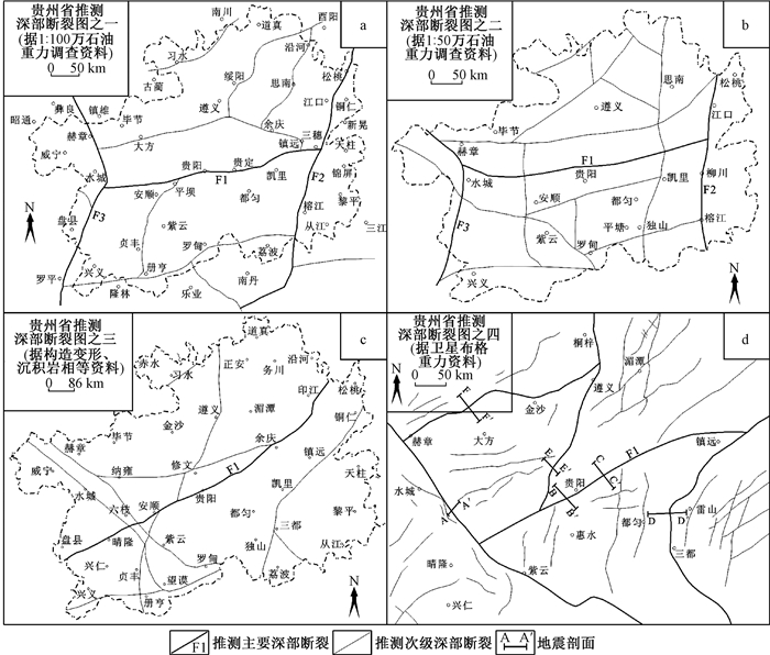
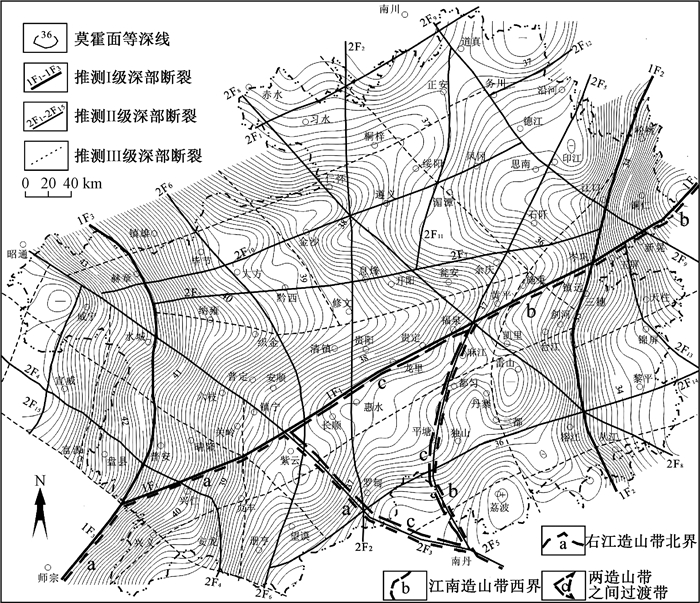
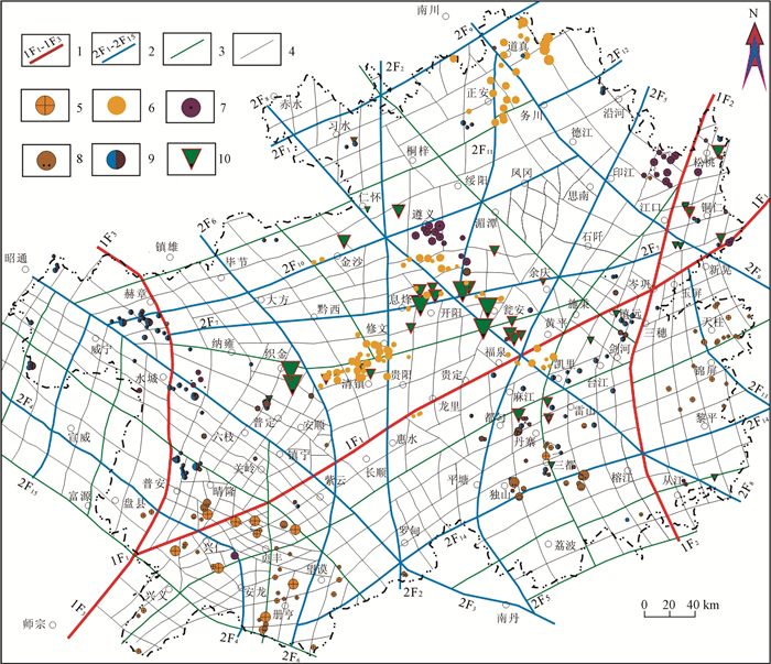
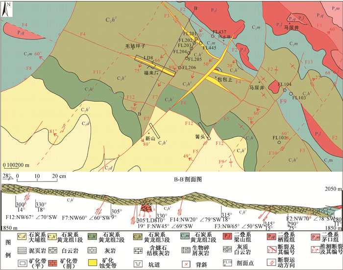
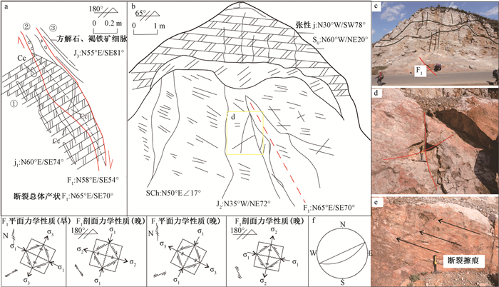
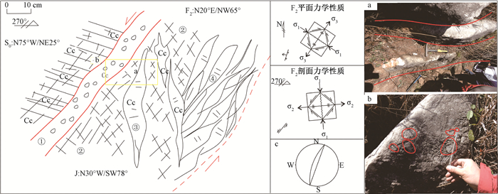
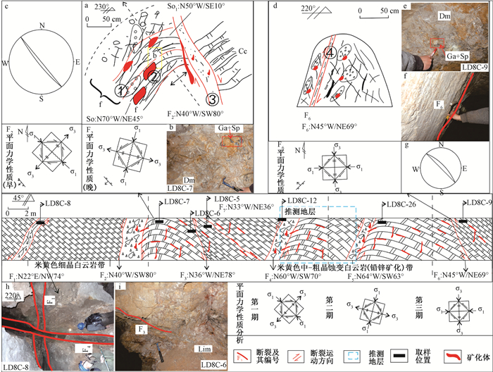
2019 Vol. 25, No. 1

Display Method:
Contents
2019, 25(1): .
Abstract (78) PDF (365KB)(16)
Abstract:
Chief Editor’s Address
2019, 25(1): 1-2.
Abstract (81) PDF (395KB)(18)
Abstract:
TECTONIC DYNAMICS OF FLUIDS AND METALLOGENESIS
XU Xingwang, NIU Lei, HONG Tao, KE Qiang, LI Hang, WANG Xuehai
2019, 25(1): 1-8. doi: 10.12090/j.issn.1006-6616.2019.25.01.001
Abstract (158) HTML (101) PDF (12949KB)(36)
Abstract:
Fluid is an important constitute of the earth, and tectonics and dynamics of fluids are major research branches of geomechanics and tectonics. Tectonic dynamics of fluids is a new interdisplinary subject among fluid geology, geomechanics and structural geology. This contribution introduces the concept and the framework of the subject of tectonic dynamics of fluids. In addition, it summarizes a series of important advances in the study of tectonic dynamics of fluids and metallogenesis in recent years, including coming up with the new mechanics for fracture caused by hydraulic pressure, discovering the porphyry accumulation structure, indicating porphyry as the product of reemplacement of some crystallized residual magma in magma chamber, discovering and determining tectonic peperite, and so on. Moreover, some new research advances are also presented here. Finally, some key scientific questions are pointed out. It is concluded that fluids not only create fractures and spaces for ore-forming fluids to be transported and to precipitate but also transport and enrich ore-forming elements, thus laying a foundation for the final formation of ore deposits.
THE APPLICATION OF THE INTEGRATED GEOLOGICAL, GEOPHYSICAL AND GEOCHEMICAL PROSPECTING METHOD IN THE DISCOVERY OF THE LONGTOUSHAN LEAD POLYMETALLIC DEPOSIT IN NORTHERN HEBEI PROVINCE
WANG Jian, ZHU Lixin, MA Shengming, ZHOU Weiwei, CHEN Fenghe, SU Zhenhua, JIA Zhichao
2019, 25(1): 9-18. doi: 10.12090/j.issn.1006-6616.2019.25.01.002
Abstract (292) HTML (92) PDF (23232KB)(31)
Abstract:
Concealed ore is the key object of mineral exploration at present. Based on the 1:200000 regional prospecting information in northern Hebei province, the Longtoushan prospecting target around the Zhuizishan granite mass has good prospecting potential. 1:50000 geochemical survey of stream sediement delineates 11 comprehensive anomalies, among them, H6 anomaly is the mineral-induced anomaly. The results of the 1:10000 geological, geophysical and geochemical survey show that anomaly of Ag, Pb, Zn, Au and other elements have high outlier values, with three levels of zones from the outer zone, middle zone to the inner zone. It has the characteristics of low resistance and high polarization induced electrical anomaly. Altered and mineralized zones are coupled with geophysical and geochemical anomalies. Through systematic geophysical and geochemical survey of different scales and the engineering verification, the Longtoushan lead polymetallic deposit was discovered. Orebodies occur in the F3 fault system with NWW extending and 30~60 m wide. The wall rocks are the archean Dantazi group gneiss and late Jurassic Zhangjiakou group andesite. The ores are mostly vein-disseminated and dense block structured, and the deposit features are similar to the adjacent Xiaokouhuaying deposit, the Niujuan deposit and other polymetallic deposits, belonging to the medium-low temperature hydrothermal vein type lead polymetallic deposit. According to the characteristics of geological, geophysical and geochemical prospecting information, the integrated prospecting model is established and the prospecting indicators of hydrothermal vein type lead polymetallic deposits are determined, which is conducive to advancing the prospecting and exploration in northern Hebei province.
THE EFFICIENT MECHANISMS FOR PRECIPITATING WOLFRAMITE: CO2 ESCAPING
LIU Xiangchong, ZHANG Dehui
2019, 25(1): 19-26. doi: 10.12090/j.issn.1006-6616.2019.25.01.003
Abstract (224) HTML (133) PDF (4817KB)(16)
Abstract:
Wolframite is the main ore mineral of vein-type tungsten deposits. How wolframite precipitates from hydrothermal fluids is highly disputed in the literature. Whether CO2 escaping causes significant precipitationof wolframitehas not been quantitatively examined. A reaction equilibrium model for the system of W-Fe-Na-Cl-H-C-O was established in this contribution. The model contains 22 species and 16 reactions, the thermodynamic data of which are from the database SUPCRT. The modeling results indicate that pH is negatively correlated to fluid pressure and tungsten solubility is positively correlated to fluid pressure. A decreasein fluid pressure from lithostatic to hydrostatic level could cause a drop of tungsten solubility by 27%~47%, and the decrease degree has a positive correlation to temperature and depth. Therefore, CO2 escaping accompanying a drop of fluid pressure is one of the mechanisms precipitating wolframite efficiently.
ORE-CONTROLLING FACTORS OF THE BAERZHE SUPER-LARGE DEPOSIT IN JARUD BANNER, INNER MONGOLIA
CHEN Jinyong, FAN Honghai, WANG Shengyun, ZHANG Chuang, ZHAO Jingyang, GENG Ruirui
2019, 25(1): 27-35. doi: 10.12090/j.issn.1006-6616.2019.25.01.004
Abstract (291) HTML (108) PDF (19170KB)(45)
Abstract:
The Baerzhe deposit is not only a REE-Zr-Nb-Ta-Be super-large polymetallic deposit, but also a large U-Th deposit. Uranium and thorium mainly exist in the form of isomorphism. The minerals of beryllium and rare earth elements are mainly yttroceber-ysite and monazite. Niobium, tantalum and zirconium are mainly hosted in niobite, pyrochlore and zircon. Besides, in this paper, the ore-controlling factors of Baerzhe super-large deposit are analyzed from three aspects of structure, lithology and alteration. The results show that uranium-thorium mineralization is closely related to REE and rare elements mineralization in the Baerzhe deposit, and all of them occur in strongly altered riebeckite granite. Alteration is mainly albitization and silicification. The deposit is controlled by tectonics and alkaline granite body, and it is a product of structure and alkaline granitic magma evolution.
CORRELATION BETWEEN THE STRUCTURAL CHARACTERISTICS OF THE DEEP FOUR-LEVEL FAULT AND THE IMPORTANT MINERAL DEPOSITS IN GUIZHOU PROVINCE
WANG Liang, HU Congliang, ZHANG Jiawei, CHEN Guoyong
2019, 25(1): 36-51. doi: 10.12090/j.issn.1006-6616.2019.25.01.005
Abstract (253) HTML (174) PDF (17136KB)(56)
Abstract:
Guizhou Province is located at the convergent parts of the Yangtze Plate, Jiangnan Orogen and Youjiang Orogen. Several major tectonic extensions and structural deformation due to tectonic compressions have taken place since the Neoproterozoic Era. However, the sedimentation that occurred after the late Paleozoic Era had covered those early geological structures. Studies on the deduction of the deep fractures in Guizhou Province by several authors are still limited in scope and controversial due to the insufficient data and differences in perception. In this paper, the deep four-level fault in Guizhou Province was classified with a combined application of gravity, aeromagnetic survey technologies, and geological data, which is supported strongly by the existing studies. According to the deduced results, other than the three pieces of deep Level Ⅰ fractures, which had "H-shaped" structures, 15 pieces of Level Ⅱ fractures, 12 pieces of Level Ⅲ fractures, and several pieces of basement fractures were also found. It was also deduced that each of the said fractures was resulted by the development of the fracture-level right above it. According to the artificial seismic profile, the distribution characteristics of five of the fault pieces from Level Ⅰ to Ⅲ have been tested further. The results showed that those fractures were extended to different directions and the cutting depth had reached 6~12 km. To conclude, the fractures' profile as deep fractures, which cut through the sedimentary mantle and basement, had been confirmed. Furthermore, combining the knowledge of the four-level fault and the distribution of important mineral deposits in Guizhou Province, a deduction was put forward, wherein a spatial correlation that linked the distribution of the gold, lead and zinc, antimony, manganese, phosphorus, and bauxite ores in Guizhou Province with the Level Ⅰ, Ⅱ, and Ⅲ deep fractures might have existed.
DEEP STRUCTURAL-GEOCHEMICAL CHARACTERISTICS AND BURIED ORE-BODY PREDICTION IN THE HATU GOLD DEPOSIT
Dilixiati·MAIMAITI, Kayishaer·ERESI, WANG Yong, BAI Yuxiu, WANG Junlin, WANG Renke, LIU Bo, LIN Caixiang
2019, 25(1): 52-60. doi: 10.12090/j.issn.1006-6616.2019.25.01.006
Abstract (351) HTML (165) PDF (19384KB)(49)
Abstract:
Based on the sampling of ore bodies and surrounding rock systems at the surface and deep of the Hatu gold mine, and the study of quartz inclusions and oxygen isotopes, it is believed that the Hatu gold mine is an orogenic type medium-low temperature mixed hydrothermal gold deposit. The statistical results of ore-bearing fractures show that the occurrence and the quantity fluctuation of shallow ore-bearing structures vary widely. The rocks are mainly brittle deformed, and under the action of torsional stress, more tensile fractures are formed, which are distributed in an anechelon pattern. The number of deep faults decreases significantly, and the range of occurrence change narrows. Due to the increase of rock confining pressure, brittle deformation turns to plastic transformation, tensile fractures doesn't develop, and quartz vein-type ores become quartz fine vein+altered rock type or altered rock type. Through analyzing the spatial changes of the contents of Hg, Au, Ni, Pb, As, Sb, Cu, W, Zn, Ag, Mo and Bi in metallogenic halo, it is found that the geochemical primary halo is affected by the sharp extinction of the ore-bearing structure, and there is the superposition structure of the front and tail halo. In addition, it is known that the lower part of the vein group is mainly a combination of tail halo elements. Although there are anomalies of the front halo elements Sb and As, the scale and intensity are small. Combined with the characteristics of the downward attenuation of the number and scale of ore-bearing faults, it is believed that the deep part may still have hidden ore bodies, but the scale is not large.
THE EARLY-CRETACEOUS TECTONIC EVOLUTION AND THE SPATIAL-TEMPORAL FRAMEWORK OF MAGMATISM-MINERALIZATION IN ZIJINSHAN ORE-FIELD, FUJIAN PROVINCE
PAN Tianwang, YUAN Yuan, LYU Yong, SHI Wenqiang
2019, 25(1): 61-76. doi: 10.12090/j.issn.1006-6616.2019.25.01.007
Abstract (334) HTML (137) PDF (16337KB)(26)
Abstract:
This paper presents a systematic review of major types and characteristics of the representative deposits in the Zijinshan ore-field by integrating with previous studies, which is in an attempt to establish the spatial-temporal framework of magmatic-metallogenic events during 145~92 Ma time interval and, on that basis, investigate its relationship with the NW-trending Shanghang-Yunxiao mineralization belt under the Early Cretaceous extension setting. We conclude that the magmatism-mineraliztion of the Zijinshan ore-field was mainly controlled by the multiple activation of the NW-trending Shanghang-Yunxiao deep fault in response to Pacific plate subduction. There occurred a small scale of the magmatism and metallogenesis in the Zijinshan ore-field when the regional tectonic regime inversed from compression to extension (145~125 Ma), whereas the intense crust-mantle interaction induced large scale of magmatism and mineralization during the 110~92 Ma in response to the enhanced crust extension, which resulted in generating the giant Zijinshan porphyry-epithermal Cu-Au-Mo-Ag ore system. It's worth noting that a transient tectonic inversion lasted from 125~110 Ma separated the two extension stage mentioned above. These transpression gave rise to the short magmatic quiescence in our study area.
STRUCTURAL ORE-CONTROLLING MODEL AND PROSPECTING RESEARCH FOR THE DULONG SN-ZN-IN POLYMETALLIC DEPOSIT, SOUTHEASTERN YUNNAN
XUE Wei, ZHANG Da, LI Chengyuan, FANG Ye, CHEN Zidan
2019, 25(1): 77-89. doi: 10.12090/j.issn.1006-6616.2019.25.01.008
Abstract (212) HTML (178) PDF (72896KB)(24)
Abstract:
The Dulong Sn-Zn-In polymetallic deposit is situated in the south of the Laojunshan deposit-accumulated area, southwestern margin of the South China block. It is an important source of Sn-Zn-In polymetallic resources and has obvious structural ore-controlling characteristics. Detailed field study of the Tongjie and Manjiazhai area showed that the contact relationship of strata is all tectonic contact, and the structural styles mainly include extensional slip and left strike slip. The Early Cretaceous extension slip structure is the most important ore-controlling structure in the mining area and consists of three north-south decollement faults:F0, F1 and F2, and the mineralization, alteration and characteristics of the ore-body are mainly controlled by these faults. The Maguan-Dulong faults are NW-trending strike slip faults. These faults are post-mineralization faults and they control the north boundary of the deposit. The property of normal faults make the erosion degree of the mining area relatively low, which plays an advantageous role in the preservation of the deposit. Based on the characteristics of ore-controlling structures and the regional tectonic setting, the ore-controlling model of the Dulong deposit is proposed. It is believed that the deep south of the Dulong area, the west of the Cambrian strata and the deep Xinzhaiyan formation are favorable areas for the further exploration for tin, zinc and indium ores and the deep mining areas have great prospecting potential.
THE GENERATION, DEVELOPMENT AND ORE-CONTROLLING OF STRUCTURES OF THE FULAICHANG LEAD-ZINC DEPOSIT, NORTHEASTERN GUIZHOU
CHENG Chen, HAN Runsheng, WANG Lei, XIAO Xianguo, HE Zhiwei, LI Bo, ZHOU Xuanling
2019, 25(1): 90-104. doi: 10.12090/j.issn.1006-6616.2019.25.01.009
Abstract (224) HTML (83) PDF (71147KB)(32)
Abstract:
The Fulaichang lead-zinc deposit (FL-ZD) is located in the southwestern part of the Yadu-Mangdong Pb-Zn Metallogenic belt in northwestern Guizhou, China, Which is suited between the Tianqiao lead-zinc deposit and the Maomao lead-zinc deposit, and the distributions of the deposit and its ore bodies are strictly controlled by the structure. Based on the theory and method of geological mechanics of ore-field, the large scale fine survey of structural section and the typical identification of ore-controlling structural mechanical properties, as well as the screening of faults and fold structures in different directions in the lead and zinc mining area of Fulaichang mining area were made. It is believed that since the late Indosinian-Himalayan period, there have been three periods of tectonic activities in this region, and the main compressive stress direction has experienced the transition from NW to NE to near EW respectively. Based on analyzing the ore-controlling characteristics of folds and faults in the mining area, it is concluded that the ore-guiding structure, ore-distribution structure and ore-bearing structure of the deposit are the checkerboard-type structure of the tectonic framework, the NE-trending faults (inclined NW) and NWW fault-trending, and the interlayer fault zones in the lower plate of NWW-trending faults, respectively. In addition, there are NW trending (NNE trending) ore-breaking structures in the mining area, which obviously cut and shift the ore bodies and control the spatial positioning of the ore bodies. On the basis of summarizing the structural ore-controlling regularity, the ore-forming tectonic system of the deposit is established, which lays a foundation for ore prospecting and genetic study of the deposit.
GRAVITY AND MAGNETIC FIELD CHARACTERISTICS AND HYDROCARBON PROSPECTS OF THE NANWEIXI BASIN
FENG Xuliang, LIU Bin
2019, 25(1): 105-114. doi: 10.12090/j.issn.1006-6616.2019.25.01.010
Abstract (170) HTML (85) PDF (34889KB)(8)
Abstract:
Characteristics of gravity and magnetic anomalies and their geological significance are analyzed in order to identify prospective zones for hydrocarbon exploration in the Nanweixi Basin. The northern depression and northern uplift of the Nanweixi Basin are characterized by high gravity and high magnetism, indicating strong volcanic activities in this region. The central depression, southern uplift, and the northern part of the southern depression are characterized by local high gravity and magnetic anomalies with clumpy and isoaxial shape on the overall low gravity and magnetic amomaly background, which is a comprehensive reflection of volcanic rocks and carbonate platforms. The thickness of the Cenozoic in the Nanweixi Basin is characterized by NE trending thin-thick bands, and the thickness in the southern depression is the largest, followed by the central depression. The northern part of the basin is located in the upheaval of the Moho surface, while the Moho surface is relatively deep in the southern part of the basin, which manifests as the feature of thinned continental crust. Curie surface of the northern depression and northern uplift are relatively shallow, which may be related to the strong extension and thinning of lithosphere and the mantle material invasion caused by the expansion of the South China Sea. Curie surface in the central depression and the southern uplift is shallower than which is in the south depression, indicating that the central depression and the southern uplift have much stronger underlying thermal activities than those of the southern depression. The Nanweixi Basin has relatively favourable hydrocarbon prospects from the gravity and magnetic field characteristics and their inversion results and the petroleum geological features. The central depression, southern uplift and the southwestern peripheral regions of the basin are the best potential hydrocarbon prospect zones, followed by the southern depression. In the favourable hydrocarbon zones, some high gravity anomaly area with local clumpy and isoaxial shape may indicate carbonate platform and organic reef, which should be the future exploration target.
INTERLAYERED OXIDATION-ZONE STYLES IN FAULT-FOLD BELTS OF THE NORTHERN TARIM BASIN AND ITS CONTROLLING TO THE FORMATION OF SANDSTONE-TYPE URANIUM DEPOSITS
LU Kegai, WANG Guorong, SUN Xiao
2019, 25(1): 115-124. doi: 10.12090/j.issn.1006-6616.2019.25.01.011
Abstract (461) HTML (146) PDF (37289KB)(16)
Abstract:
The northern rim of the Tarim basin was strongly deformed, forming series of fault-fold belts, where was lack of stable gentle slope zones which are generally regarded as favorable for the formation of sandstone-type uranium deposits. Most recently discovered sandstone-type uranium deposits hosted in Middle Jurassic and Pliocene are different because of various interlayer oxidation zone styles. The interlayer oxidation-zone styles could be divided into two different types, including steep dipping and inverse transformation. The former type of zones are usually situated in the intermountain residual fault basin, or near the piedmont faults. Most parts of this type of oxidation zones had been denudated and only partially preserved. The latter zones are generally controlled by the uplifting of anticlinorium in the basin. As a result, inversion tilting leads to part of the transition zone and uranium anomaly-bodies eroded out to the surface. Main uranium ore-bodies in these deposits behave as roll-back and part of lenticular in shape. Therefore, comprehensive studies suggest that the favorable uranium mineralization should probably be located at the sag areas, the edge of the first low fault-fold zones, and some other blind fault-fold belts.
DEVONIAN MAGMATISM IN THE NORTHERN MARGIN OF THE NORTH CHINA BLOCK AND ITS TECTONIC SETTING
ZHANG Qiqi, ZHANG Shuanhong
2019, 25(1): 125-138. doi: 10.12090/j.issn.1006-6616.2019.25.01.012
Abstract (205) HTML (69) PDF (7172KB)(25)
Abstract:
Late Paleozoic-early Mesozoic magmatic rocks are widespread along the northern margin of the North China Block and constitute an east-west belt that is about one thousand kilometers long. As a part of the late Paleozoic-early Mesozoic magmatic belt, the distribution of the Devonian magmatic rocks is not common as that of the Carboniferous-Permian magmatic rocks. However, in recent years, more and more Devonian magmatic rocks have been identified and their geological background and tectonic implications have been much more attractive than before. Our research in combined with previously published results indicate that the Devonian magantism along the northern North China Block occurred mainly during 400~360 Ma. Among them the Devonian alkaline intrusive rocks and mafic-ultramafic intrusive rocks are distributed along the northern North China Block from Guyang to Chifeng areas and their emplacement occurred mainly during 400~380 Ma. The Devonian volcanic rocks are mainly distributed in Chifeng area in the eastern part of the northern North China Block and their eruption occurred during two peaks at 400 Ma and 360 Ma, respectively. The Devonian intrusive rocks consist mainly of monzonite, syenite and alkaline granite with minor monzodiorite and mafic-ultramafic rocks. The Devonian volcanic rocks are composed mainly of metamorphic rhyolitic rocks and metamorphic basaltic andesite, metabasalt (plagioclase amphibolite) and exhibit characteristics of bimodal volcanic rocks. Rock association, weak deformation fabrics, and geochemical and isotopic characteristics of the Devonian magmatic rocks, as well as the tectonic evolution history suggest that formation of the Devonian magmatic rocks in the northern North China Block is related to post-collisional extension after arc-continental collision between the Bainaimiao arc and the northern North China Craton during the latest Silurian. The Devonian magmatic rocks identified from the northern North China Block in recent years are of great significance to better understand the continental crustal growth of the northern margin of North China Block during late Paleozoic period and timing for final closure of the Paleo-Asian ocean.
THE PETROGENESIS AND TECTONIC SETTING OF THE ORE-BEARING MAFIC LAYERED INTRUSIONS IN LALA AREA, WESTERN SICHUAN
SUN Junyi, YU Wenjia, CUI Jiawei, LI Zhong, LUO Zhaohua
2019, 25(1): 139-150. doi: 10.12090/j.issn.1006-6616.2019.25.01.013
Abstract (192) HTML (103) PDF (18416KB)(10)
Abstract:
The ore-bearing mafic layered intrusions in Lala District, Western Sichuan Province, is located on the west margin of the Yangzi platform with complex tectonic environment, and there is still a lack of systematic research on its genesis mechanism and magmatic source. The main, trace elements and Sr-Nd isotopes of the seven lithofacies belts are analyzed in this article, and the results show that the seven lithofacies belts (YWS-1-YWS-7) were formed by different evolution processes of magma. The fifth lithofacies (YWS-5) represents the magma derived from mantle contaminated by earth crust, with high SiO2 content (42.95%~44.07%), low MgO content (1.62%~1.89%), obviously low total amount of rare earth elements (295.32×10⁻⁶~366.36×10⁻⁶), low content of Cr, Ni, 87Sr/86Sr 0.7391~0.7812; other lithofacies represent the magma derived from lithospheric mantle source area, with high Mg#content (0.54~0.74), high content of rare earth elements (672.53×10⁻⁶~986.66×10⁻⁶), 87Sr/86Sr 0.7087~0.7097.Based on the analysis of regional geological background, it is concluded that the layered intrusions were produced in continental rift tectonic environment and the magma originated from lithospheric mantle source area, with crystallization differentiation and multiple pulsations associated in the evolution process. This process is related to the Neoproterozoic super mantle plume activities on the western margin of the Yangtze plate.
Inside Cover
2019, 25(1): 151-151.
Abstract (79) PDF (10257KB)(14)
Abstract:
Inside Cover
2019, 25(1): 152-152.
Abstract (187) PDF (10764KB)(52)
Abstract: