

Late Quaternary surface deformation and tectonic implications of the Bue Co strike-slip fault system in central-western Qiangtang block
-
摘要: 班公-怒江缝合带(班怒带)是青藏高原内部羌塘地块与拉萨地块之间的重要边界,研究该边界带上共轭走滑断裂第四纪晚期的几何结构与变形特性对于理解高原内部在印度-欧亚板块碰撞作用下形成的空间差异响应和构造模型具有重要意义。位于班怒带西段的布木错断裂系包括北东向布木错断裂和北西向纳屋错断裂,通过遥感解译和野外地质调查,明确了这两条断裂在第四纪晚期的构造特征和最新的地表变形特征。结果显示,两条断裂自第四纪晚期以来的活动特征明显,并且近期都经历过一次大地震,产生了地表破裂。据此推测班怒带西段北西、北东两组断裂的最新活动强度接近,羌塘地块南部边界现今变形可能受控于两组断裂的共同影响,并已延伸至块体内部。以上发现进一步证明,青藏高原内部物质受中—下地壳流的驱动作用,通过走滑断层和正断层持续向北扩展。Abstract:
Objective The Bangong-Nujiang Suture Zone (BNSZ) serves as a boundary between the Qiangtang and Lhasa terranes of the Tibetan Plateau. The geometric structure and deformation characteristics of the "V" -shaped conjugate strike-slip faults along this late Quaternary boundary are important for understanding the spatially variable responses and tectonic models formed within the plateau as a result of the India-Eurasia plate collision. However, previous studies have primarily focused on the kinematic properties and activity rates of strike-slip faults in the eastern segment of the suture zone. The scarcity of information on the activity characteristics of strike-slip faults and paleoseismic events in the western segment of the suture zone has hindered our understanding of regional tectonic deformation and seismic activity. The Bue Co fault system, located in the western section of the BNSZ, is a (conjugate) strike-slip fault system consisting of the NE-trending Bue Co and NW-trending Lamu Co faults. Methods This study employs a combination of remote sensing interpretation and field surveys, utilizing high-resolution Digital Surface Models (DSM) collected by unmanned aerial vehicles (UAV) to conduct a detailed analysis of surface ruptures and systematically decipher the geometric morphologies and late Quaternary deformation evidence of the NE-trending Bue Co Fault and the NW-trending Lamu Co Fault in the western section of the BNSZ. Results This study revealed significant fault activity since the late Quaternary period, with evidence of recent large earthquakes that caused surface ruptures extending >60 km along both faults. The Bue Co fault exhibits left-lateral strike-slip, with recent seismic displacements ranging from 3.7 to 4.2 m, whereas the Lamu Co fault shows right-lateral strike-slip with minimum displacements of 2.7 m. Both faults display normal faulting components in their surface rupture zones, and the vertical displacements are cumulative across landforms of various ages, indicating long-term fault activity. The latest activity intensities of the NW and NE faults in the western BNSZ were similar, suggesting that the deformation of the southern boundary of the Qiangtang block may be controlled by both fault sets, which extend into the interior of the block. Conclusion These findings reveal that (1) both the Bue Co and Lamu Co faults can generate strong earthquakes of magnitude ≥7, indicating active tectonic deformation and a high seismic hazard potential in the western section of the BNSZ; (2) the deformation in the western BNSZ is concentrated along the NW-trending strike-slip faults and active along the NE-trending strike-slip faults, which may jointly control the southern boundary of the eastward extrusion of the Qiangtang terrane and have extended into the interior of the terrane; and (3) the continuous deformation pattern is supported, revealing that material within the Tibetan Plateau is driven by mid-lower crustal flow extruding eastward, with the southern boundary of the extrusion potentially continuing northward through a series of strike-slip and normal faults. Significance These conclusions deepen our understanding of the activity and seismic potential of strike-slip faults in the western BNSZ and provide novel insights into the internal tectonic deformation patterns and dynamic background of the Tibetan Plateau. Furthermore, this study provides an essential theoretical foundation for regional stability assessments and disaster mitigation planning. -
0. 引言
印度-欧亚碰撞造就了青藏高原新生代以来宏伟的地质地貌景观(Molnar and Tapponnier, 1975;Harrison et al., 1992;Clark and Royden, 2000;Yin and Harrison, 2003;吴中海等,2006),并在高原内部形成了与周缘地区迥异的构造变形特征(Elliott et al., 2010)。大型活动断层的几何学和运动学研究对于理解大陆构造演化和地震破裂的动力学机制起到重要的约束作用(Tapponnier et al., 2001a;Meade,2007;Molnar and Dayem, 2010)。高原内部的活动构造类型以正断层和走滑断层为主,共同控制着一系列晚新生代以来的伸展型盆地和湖泊,而逆冲断层则通常发育在高原周边的造山带上(Molnar and Tapponnier, 1975,1978;Armijo et al., 1986,1989;England and Houseman, 1989;Tapponnie et al., 2001b;Taylor and Yin, 2009)。班公-怒江缝合带(班怒带)是青藏高原内部一条近东西向的重要构造带。据GPS显示,该构造带以北块体的近地表物质呈明显的向东运动趋势,因此被视作高原物质向东运移的南部边界(Tapponnier and Molnar, 1976,1977;Gan et al., 2007)。北东向左旋走滑和北西向右旋走滑断层是沿班怒带发育的标志性活动构造,二者相交组合成一系列“V”字形共轭走滑断裂系(Taylor et al., 2003;Taylor et al., 2011;Yin and Taylor, 2011)。这些断裂与南北两侧的近南北向裂谷/地堑相接,形成一条长1500~1800 km、宽200~300 km的近东西向强烈变形带,被认为是高原内部调节印度-欧亚板块汇聚的主要构造形式(Armijo et al., 1986,1989;England and Houseman, 1989;Taylor et al., 2003;Ratschbacher et al., 2011;Yin and Taylor, 2011;Sundell et al., 2013;Styron et al., 2015)。
值得注意的是,自史料记载以来,班怒带上发生的6级以上大震、强震主要集中在中东段(改则县以东)地区,包括1951年崩错8.0级大震;而西段(改则县以西)地震的次数和强度均低于中东段,且西段走滑断层连续性较中东段略差,单条断层的延伸距离也更短,这些差异也引发了对班怒带西段断层发震行为和变形模式的思考。正确判断该地区(共轭)走滑断裂是否在全新世活动、活动强度与邻区活动构造的差异性、以及是否具备产生大震的能力,是了解班怒带西段第四纪晚期应力传递和应变分布的关键问题之一,也是验证高原变形模式合理性的重要突破口。然而,由于缺乏对班怒带西段走滑断裂活动的野外观测和相关的古地震报道,极大地限制了对上述问题的理解与认识。
布木错断裂系是班怒带西段最为典型的活动构造之一,包括南部的纳屋错断裂(北西向)和北部的布木错断裂(北东向)。两条断裂第四纪晚期构造活动特征显著,是研究班怒带西段活动断裂地表变形和发震行为的理想对象。对于这样一对规模较大、研究基础薄弱的区域走滑断裂系,有许多有价值的科学问题亟待探索。为了更深入地理解班怒带西段的构造变形与演化,以两条断裂带上的地表破裂为切入点,在详细的遥感解译的基础上,通过实地考察验证,结合无人机(UAV)采集的高分辨率数字表面模型(DSM),系统解析地形地貌,以确定破裂带的几何形态并提供相应的变形证据。以上工作可以帮助更深入了解班怒带西段走滑断裂系的最新地震活动模式,进一步探索羌塘西部及其邻近地区的动力学机制,并为未来地震导致的地表不稳定性等问题提供理论依据。
1. 区域地质概况
班怒带走滑断裂系西起班公湖、东至嘉黎,总长度约为1500 km,由一系列长度不等的北东、北西向走滑断裂组成。北东向断裂为左旋走滑,北西向断裂为右旋走滑,构成了钝角代表主压应力方向的共轭断裂系。代表性的包括洞错走滑断裂系、布木错走滑断裂系、埃永错走滑断裂系等,组合形式多呈开口向东的“V”字型构造,常与南部拉萨地块和北部羌塘地块上的裂谷和正断层相接(图 1a)。缝合带北侧羌塘地块上的正断层沿左旋的依布茶卡断裂、布木错断裂和先且错断裂发育,而南侧拉萨地块上的裂谷则与右旋的格仁错断裂、崩错断裂、纳屋错断裂等走滑断层的东端相连(Armijo et al., 1986,1989;Yin et al., 1999;Yin,2000;张进江和丁林,2003),两组断裂的交汇处或转换带上往往形成地堑或裂谷(Mercier et al., 1987)。Armijo et al. (1986,1989)认为,班公-怒江缝合带上的北西向右旋走滑断裂从西到东构成了羌塘南部的一条完整边界,是控制北侧羌塘地块作为刚性块体向东挤出的右旋简单剪切带,滑移速率高(10~20 mm/a)。Taylor et al. (2003)则认为北西、北东向两组走滑断层的位移量接近(每条约10~12 km),滑移速率相对较低(2~3 mm/a),形成于南北向挤压环境下的纯剪切连续变形。而Yin and Taylor(2011)进一步提出,“V”字型走滑断裂系形成的先决条件是中下地壳存在向东运动的软弱隧道流。张进江等(2013)认为青藏高原内部钝角为主压应力方向的共轭走滑断裂受最大有效力矩准则控制,是南北向缓慢挤压过程的产物,而近南北向裂谷则是在快速变形时形成。另有一些学者发现班怒带上的走滑断裂仅代表了部分高原内部的共轭走滑断裂,羌塘块体内部也同样分布着规模各异、连续性较差的北东、北西向走滑断层(Han et al., 2019;图 1b)。
 图 1 研究区区域地质图LGF—龙木错-郭扎错断裂;KF—喀喇昆仑断裂;BF—布木错断裂;LCF—纳屋错断裂;RPF—日干配错断裂;GCF—格仁错断裂;BCF—崩错断裂;JF —嘉黎断裂;KLF—昆仑断裂;QNT—柴达木北缘逆冲带;GZF—甘孜断裂;LBF—龙日坝断裂;XXF—鲜水河-小江断裂;LMF—龙门山断裂;HF—海源断裂;ATF—阿尔金断裂
a—青藏高原活动断裂构造纲要图(据Taylor and Yin, 2009修改);b—羌塘中西部地区布木错断裂系及邻区主要活动断裂分布图Figure 1. Regional geological map of the study area(a) Schematic tectonic map of the active faults in the Tibetan Plateau (modified after Taylor and Yin, 2009); (b) Distribution map of major active faults in the Bue Co fault system and adjacent areas in the midwestern Qiangtang
LGF-Longmu-Guozha fault; KF-Karakoram fault; BF-Bue Co fault; LCF-Lamu Co fault; RPF-Riganpei Co fault; GCF-Gyaring Co fault; BCF-Ben Co fault; JF-Jiali fault; KLF-Kunlun fault; QNT-North Qaidam thrust belt; GZF-Ganzi fault; LBF-Longriba fault; XXF-Xianshuihe-Xiaojiang fault; LMF-Longmenshan fault; HF-Haiyuan fault; ATF-Altyn Tagh fault过去二三十年中,随着大量遥感解译和第四纪地质体位移以及年代学定量化研究的不断深入,班怒带上(共轭)走滑断裂的相关成果也在相继发表。例如,格仁错断裂右行走滑速率为2~5 mm/a(杨攀新等,2012;Shi et al., 2014;Wang et al., 2016),日干配错断裂晚更新世左旋走滑速率为0.2~0.3 mm/a(刘富财等,2022)。这些速率远小于通过大地测量和GPS获得的走滑活动速率,如合成孔径雷达干涉测量(InSAR)测得日干配错断裂左旋走滑速率为~6 mm/a,纳屋错、布木错和洞错断裂的速率在1~3 mm/a,格仁错断裂走滑速率在8~21 mm/a(Taylor and Peltzer, 2006)。此外,最新的大地测量数据表明,右旋走滑断层的近期滑移率约为2~10 mm/a(Chen et al., 2004;Zhang et al., 2004;Gan et al., 2007),而崩错断裂(1~4 mm/a;Garthwaite et al., 2013)、纳屋错断裂(0.1~8.0 mm/a;Taylor and Peltzer, 2006)的滑移率可能更低。上述数据表明班怒带上走滑断裂的活动速率远低于块体边界走滑断裂,如鲜水河断裂、红河断裂、喀喇昆仑断裂和阿尔金断裂(Van Der Woerd et al., 1998,2000;Mériaux et al., 2005;Chevalier et al., 2012,2016;Bai et al., 2018;韩明明等,2022)。然而,在班怒带西部,尤其是改则县以西的广袤地区,由于恶劣的工作环境和交通不便,开展系统的地质地貌调查工作困难重重,因此目前依旧缺乏直接的地质观测数据。
布木错断裂系位于羌塘地块西南部革吉县北部(图 1b),是班怒带西段的一对(共轭)走滑断裂系。该断裂系向北临近鲁玛江东错正断层,向南与次定错地堑北端相交,由北东向布木错左旋走滑断裂(图 2a)和北西向纳屋错右旋走滑断裂(图 3)组成(Taylor et al., 2003),单条长约120~150 km。从遥感影像上可以看出,断裂经过处发育明显的线性陡坎,尤其是纳屋错断裂错断了一系列第四纪晚期以来的冲沟、斜坡和冲积扇。此外,遥感显示两条断裂上均发育地表破裂带,表明近期都发生过大地震,由此揭示了班怒带西段走滑断裂系的最新活动特征。然而,高分谷歌地球影像并未显示布木错断裂上有明显的左旋位移,这意味着仅凭借遥感无法确定两组断裂第四纪晚期以来的活动习性。此外,受断层几何结构复杂性和相邻构造活动的影响,地表破裂的展布形态、构造特征和位移量可能沿断层变化。因此,进行野外实地考察显得尤为必要。
 图 2 布木错断裂带的展布特征及不同部位跨断裂带高程剖面图a—布木错断裂带分支断裂与次级断裂展布;b—e—不同部位跨断裂带高程剖面地貌特征(断层产状依据断层地貌和现今应力场环境)Figure 2. Distribution characteristics of the Bue Co fault zone and elevation profiles of different parts crossing the fault zone(a) Distribution of branch faults and secondary faults along the Bue Co fault zone; (b-e)Topographic features of elevation profile of different parts crossing the fault zone (The fault geometry is determined based on the fault topography and the current stress field environment)
 图 3 纳屋错断裂带展布特征及不同部位跨断裂带高程剖面图a—纳屋错断裂带分支断裂与次级断裂展布;b—e—不同部位跨断裂带高程剖面地貌特征(断层产状依据断层地貌和现今应力场环境)Figure 3. Distribution characteristics of the Lamu Co fault zone and elevation profiles of different parts crossing the fault zone(a) Distribution of branch faults and secondary faults along the Lamu Co fault zone; (b-e)Topographic features of elevation profile of different parts crossing the fault zone (The fault geometry is determined based on the fault topography and the current stress field environment)
2. 布木错断裂系地表破裂特征
2.1 布木错断裂带及地表破裂
布木错断裂带东起阿汝乡东南33 km处,向南西延伸至宅姆错西约37 km。布木错以西(西段),断裂的平均走向约为82°;而布木错以东(东段),平均走向约为57°。总体呈向南凸出的弧形,全长约130 km(图 2),迹线相对简单,几何结构规则且连续性较好,未发育大规模伸展盆地或挤压隆起(图 2a)。据地质资料(潘桂棠等,2004)显示,断裂两侧的地层差异明显。西段断裂北侧为二叠系砂岩和花岗闪长岩,南侧为第四纪晚期沉降区(图 2b)。与纳屋错断裂交汇处三角区内发育多条近南北向正断层,形成断陷盆地(图 2c),体现了局部引张性以及向东挤出后的后缘拉张效应(吴中海等,2022)。东段断裂南侧为二叠系紫红色砂岩和古近系钙质泥岩,北侧为断层沟谷(图 2d、2e),发育晚更新世—全新世沉积物。高分影像显示,布木错断裂西段延伸超过70 km,多沿基岩山前发育,沿途切割了断层谷两侧的基岩、冲积扇和冰川沉积物(图 4a—4d)。东段则沿查姆河流域切割了南侧的基岩山,并形成北侧的断层槽谷沉降区。东段总体延伸约60 km,未观察到水平错断的第四纪地貌。跨断裂带地表高程剖面也显示布木错断裂带东段相对于西段正断活动更为明显(图 2d、2e)。东段终止于几条走向150°~170°的正断层,正断层与主干断层近垂直相交(图 4e、4f),倾向北西,符合走滑断裂尾端常出现的拉张或挤压次级构造。
 图 4 布木错断裂带和地表破裂带典型遥感影像图a—地表破裂带西段线性特征;b—Q3-4扇体上发育地表破裂带陡坎;c—断层左旋错动水系;d—断层陡坡分隔第四纪沉积与基岩;e—地表破裂带东段未错段水系;f—地表破裂带东段以正断活动为主Figure 4. Typical remote sensing images of the Bue Co fault zone and surface ruptures(a)Linear characteristics of the west section of the surface rupture zone; (b) Fault scarp of surface rupture developed on the Q3-4 fans; (c) Left-lateral drainage offset by fault; (d) Quaternary sediments and bedrock separated by fault slope; (e) Water systems not offset by the eastern section of the surface rupture; (f) Surface rupture zone dominated by positive fault activity in the eastern section
布木错地表破裂带发育在断裂西段,西起宅姆错以东(33°13′44.00″N, 81°25′16.13″E),向北东延伸至33°24′49.75″N, 82°2′20.90″E附近,全程约65 km。破裂带整体呈线性,部分段落准线性。断层陡坎(陡坡)穿过多级第四纪地貌面,断层地貌标志保存完好(图 4a—4d)。布木错湖以西,地表破裂带切过冲积扇台地并形成断层槽谷,平均走向66°,遥感影像上可观察到清晰的线性特征(图 4a、4b)。断坡下发育长条状盆地,破裂继续向东延伸至一窄长的盐湖,长轴走向平均48°(图 5a)。野外考察发现,该地区发育平坦且连续的多级阶地(T0—T3),均被地表破裂带切穿,并在不同时期的地貌面上形成高度迥异的反向断层陡坎,反映了晚更新世到全新世期间断层活动的累积效应(图 5)。其中,T3阶地断坎高约9 m(图 5a),T2阶地断坎高2~2.5 m(图 5b),且断坡上下植被发育不同,上升盘植被较为茂盛。T1阶地断坎高约1~1.1 m(图 5c),而T0阶地断坎高0.2~0.7 m(图 5d),阶地面上测得左旋位移3.7±0.2 m(图 5d)。此外,T1阶地面上观察到冲沟左旋,冲沟下切深度较浅,野外测量左旋位移11.0±0.5 m(图 5e),并发育较为明显的地震鼓包,长轴走向为130°,长6~7 m,高0.6 m(图 5f)。然而,地震鼓包行至T0高河漫滩上逐渐消逝,可能由于后期风化侵蚀导致其失去原貌,表明最新一次古地震离逝时间相对久远。
 图 5 布木错断裂带地表破裂带构造地貌特征(位置见图 4b)a—布木错断裂带西段拉分盆地与T3阶地上断坡(镜向北东东);b—布木错断裂带T2阶地上断坡(镜向南东);c—布木错断裂带地表破裂T1阶地上断坡(镜向北东东);d—布木错断裂带地表破裂T0阶地上冲沟左旋(镜向南东);e—布木错断裂带地表破裂T1阶地上冲沟左旋(镜向南东);f—布木错断裂带地表破裂T1阶地上地震鼓包(镜向南东)Figure 5. Structural geomorphic features of the Bue Co fault coseismic surface rupture (The location refers to Fig. 4b)(a)Pull-apart basin in the western part of the Bue Co fault zone and fault slope on the T3 terrace (towards NEE); (b) Fault slope on the T2 terrace of the Bue Co fault zone (towards SE); (c) Fault slope on the T1 terrace of the Bue Co fault surface rupture (towards NEE); (d) Sinistral displacement of the gully on the T0 terrace of the Bue Co fault surface rupture (towards SE); (e) Sinistral displacement of the gully on the T1 terrace of the Bue Co fault surface rupture (towards SE); (f) Earthquake bulge on the T1 terrace of the Bue Co fault surface rupture (towards SE)
通过使用无人机进行地貌扫描,在该点生成的高分辨率数字高程模型(DSM)显示出多个冲沟发生左旋位移(图 6a),水平位移量分别为4.2±0.3 m,4.5±0.4 m,6.4±0.6 m和43.0±3.0 m (图 6b、6c;表 1)。湖盆的走向、T1阶地上发育的地震鼓包与破裂带的夹角关系同样揭示其运动学性质为左旋走滑。破裂带错动T0、T1阶地并造成小型冲沟米级的水平位移,说明活动时代较新(全新世晚期)。此次测得水平位移量的最小值在3.7~4.2 m,可能代表了最新一次地震事件的同震位移。
 图 6 布木错地表破裂带无人机测图a—布木错地表破裂带无人机高分辨率DSM影像;b、c—无人机高分辨率DSM影像上测量冲沟左旋位移Figure 6. UAV photogrammetry of the Bue Co fault coseismic surface rupture(a)High-resolution DSM image of the Bue Co fault surface rupture obtained by UAV; (b, c) Sinistral displacements of gullies measured on high-resolution DSM images obtained by UAV表 1 布木错断裂系位移量分布表Table 1. Statistic table of displacement in the Bue Co fault system
断裂名称 经度 纬度 断错标志 位移量/m 误差/m 布木错断裂 81°29′55.14″ 33°15′50.10″ 冲沟左旋 11.0 0.5 81°29′52.02″ 33°15′40.44″ 冲沟左旋 3.7 0.2 81°29′35.71″ 33°14′59.25″ 沟壁左旋 43.0 3.0 81°29′51.82″ 33°15′40.52″ 小沟左旋 4.2 0.3 81°29′54.82″ 33°15′50.25″ 小沟左旋 4.5 0.4 81°29′54.58″ 33°15′50.25″ 小沟左旋 6.4 0.6 纳屋错断裂 81°43′41.52″ 33°13′16.02″ 深沟右旋 7.3 1.2 81°43′31.62″ 33°13′20.10″ 小溪右旋 4.5 0.5 81°43′32.78″ 33°13′19.41″ 小溪右旋 2.7 0.3 81°43′33.49″ 33°13′19.10″ 冲沟右旋 13.7 1.1 81°43′40.51″ 33°13′16.28″ 小溪右旋 8.3 2.0 81°43′41.61″ 33°13′15.70″ 沟壁右旋 10.3 2.4 81°43′44.41″ 33°13′14.21″ 沟壁右旋 27.0 3.0 81°43′45.32″ 33°13′13.85″ 沟壁右旋 15.0 1.5 81°43′45.66″ 33°13′13.58″ 深沟右旋 14.0 1.5 2.2 纳屋错断裂带及地表破裂
纳屋错断裂带主干断层分为南北两支,总体呈北西西向,全长约160 km(图 3a)。断裂带南侧为山区,北侧则形成断层槽谷(图 3b、3c),并控制了串珠状湖泊(如纳屋错、茶卡错、纳热春白错、毒曲错)以及沿途水系的发育(图 3a、3c、3d、3e)。其中北支起始于布木错南岸,东至纳屋错北两山之间的鞍谷地貌,分隔了北侧的古波克错与南侧的纳屋错两个第四纪湖盆(图 3a)。该支主体位于第四纪晚期冲洪积与侏罗系灰岩的交界处,长约64 km,走向大致为130°,具有非常明显的线性特征(图 7a—7d)。断裂南支与北支通过右阶转换构造衔接,阶区宽约8 km,形成了长35 km的北西向第四纪晚期大湖(图 3a、3c)。继续向南东穿过S301省道,至文布当桑乡以东,止于罗尔跟藏布,全长约110 km。
 图 7 纳屋错断裂带和地表破裂带典型遥感影像图a—纳屋错走滑断裂带北支穿过第四纪晚期冲洪积扇及其上同震地表破裂;b—沿断裂北支地表破裂展布的晚更新世以来的冲洪积扇群;c—错不杂东南基岩与第四纪沉积以断层为界;d—多条水系沿纳屋错断层南支发生偏转;e—纳屋错断裂带东南段在第四纪湖区发育;f—纳屋错断裂带东南尾端活动痕迹变弱Figure 7. Typical remote sensing image of the Lamu Co fault zone and surface rupture zone(a)Late Quaternary alluvial fan offset by the northern branch of the Lamu Co strike-slip fault zone and co-seismic surface rupture on the fan; (b) The alluvial fan group since the late Pleistocene distributed along the surface rupture of the northern fault branch; (c) Bedrock and Quaternary deposits bounded by fault to the southeast of Cobuza; (d) Several drainage systems deflected along the southern branch of the Lamu Co fault; (e) The southeast section of the Lamu Co fault zone developed in the Quaternary lake region; (f) Diminishing activity traces at the southeast end of the Lamu Co fault zone
纳屋错地表破裂带发育在北支断裂,西起宅姆错南岸,此处遥感显示全新世河流发生明显的右旋偏转,最大可达42 m。向南东延伸至纳屋错北岸,全程约50 km。破裂带穿过布木错东侧冲洪积物上的密集水网时,导致一系列冲沟群发生右旋同步转折,位移量从几米到上百米不等,表明破裂带自第四纪晚期以来发生持续活动。向东延伸,晚更新世到全新世的冲洪积扇群沿地表破裂带规律展布。破裂带在冲洪积扇群上形成绵延数百米至数千米的反向陡坎(图 7b)。向南东可见基岩与第四纪沉积之间以断层为界,形成了断层两侧色调差异明显的地质体(图 7c)。接近纳屋错北,破裂带变得不清晰,可能终止于南支与北支之间的构造阶区。
相比于北支,南支断裂几何形态较为复杂,发育了多条次级断裂,具有断裂转折、分叉和交汇等结构(图 3a)。在纳屋错南侧的冲积扇上,隐约可见断续的陡坎,坎下发育盐碱沼泽。湖的东南侧发育一条近南北向正断层,倾向西,被命名为纳屋错东缘正断层。向南东穿过低矮的圆丘台地,在恶琼错的东侧山腰形成明显的地形坡折。同时切穿多个晚更新世冲洪积扇扇根,形成断续状断层陡坎,断坎长约数百米,部分超过1 km。众多水系沿断层陡坎发生左旋或右旋偏转(图 7d),故无法直接确定断层运动状态,可能由于此处走滑性质较弱。在达孜错以南第四纪湖相沉积区,断裂第四纪晚期走滑特征不明显(图 7e、7f),以正断活动为主(图 3d、3e)。此外,断层东南尾端发育几条与主断层呈锐角斜交的正断层(图 3a),指示了断裂带的右旋性质。上述地貌表明第四纪晚期以来,南支断层不仅具有右旋走滑运动,还兼具一定的正断分量。在文布当桑乡以南,断层谷和基岩的界线变得不再清晰(图 7f)。
为进一步明确破裂带的运动学性质与活动特征,选择布木错以东15 km处破裂形迹进行实地考察。该观察点位于冲洪积扇边缘,河源为塔查普河,顺布木错断裂的断层谷流经该区。冲积扇长约8 km,扇面开阔,由泥砂、碎石等沉积物组成。在基岩形成的低丘陵和河谷之间,发育一处明显的线状构造,破裂带主要沿二者交界展布(图 8a)。基岩的主要成分为侏罗纪灰色—灰白色灰岩、砂岩和变砂岩等(图 8b)。在冲洪积扇上形成了两条破裂陡坎,即山麓破裂和山前破裂,分别位于高处和低处(图 8a、8c)。在冲积扇前缘,破裂切过扇面形成了较陡的山前破裂,并控制了断层北盘支沟的形态。山麓破裂则相对较缓。
 图 8 纳屋错断裂带地表破裂带野外构造地貌特征(位置见图 7a)a—纳屋错断裂带地表破裂陡坎(镜向南东);b—纳屋错断裂带断层角砾岩(镜向北东);c—纳屋错断裂带位于山麓的断层陡坎(镜向北);d—纳屋错断裂带地表破裂造成冲沟右旋(镜向北东)Figure 8. Structural geomorphic features of the Lamu Co fault zone coseismic surface rupture in the field (The location refers to Fig. 7a)(a)Fault scarp of the Lamu Co fault surface rupture (towards SE); (b) Fault breccia of the Lamu Co fault zone (towards NE); (c) Fault scarp of the Lamu Co fault surface rupture located at the foothills The Lamu Co (towards N); (d) Dextral displacement of the gully induced by the Lamu Co fault surface rupture (towards NE)
沿遥感影像向东追踪,可见两条破裂切过多个晚更新世—全新世冲积扇,并伴有垂向上的不协调。其中,山前破裂表现为断层凹槽,形成的陡坎高约2~4 m,具有良好的线性特征,走向305°。地貌上,山前破裂将北东盘的丘陵与南西盘的平坦地形分隔开来,并在局部形成蓄水洼地。破裂带附近灰岩破碎严重,形成断层破碎带,部分固结成碎裂化角砾岩(图 8b)。山麓破裂与山前破裂相距约0.4 km,破裂陡坎高约5~7 m,走向290°。在断层的断折处形成了马鞍形的凹地和较低的三角面,并伴随与破裂垂直相交的冲沟转弯、断头沟和断尾沟等常见的走滑断层地貌(图 8c)。
该观察点周围发育大量由地表径流形成的冲沟、小溪和弯曲的沟谷。沟谷大小不一,在山前破裂带附近发生右旋错动7.3±1.2 m(图 8d)。此外,现场还发现其它走滑断层地貌,如闸门脊和断层沟槽等。结合水系的转折方式,可以判断其活动性质为右旋走滑。为获取更为精确的位移数据,对破裂带附近密集的冲沟群进行无人机扫描。通过精细测量生成的DSM高分影像(图 9a),得到了以下位移数据:2.7±0.3 m,4.5±0.5 m,8.3±2.0 m,10.3±2.4 m,13.7±1.1 m,14.0±1.5 m,15.0±1.5 m,27.0±3.0 m(图 9b—9d;表 1)。
 图 9 纳屋错地表破裂带无人机测图a—纳屋错地表破裂带无人机高分辨率DSM影像;b—d—无人机高分辨率DSM影像上测量冲沟右旋位移Figure 9. UAV photogrammetry of the Lamu Co fault coseismic surface rupture(a)High-resolution DSM image of the Lamu Co fault surface rupture obtained by UAV; (b-d) Dextral displacements of gullies measured on high-resolution DSM images obtained by UAV
3. 讨论
3.1 布木错断裂系两条断层的发震能力
查明断层的结构与空间展布、活动性、古地震事件等是活动断层研究的基本内容(马超等,2020)。布木错(共轭)断裂系由两条约150 km长的走滑断裂组成,每条断裂上均发育较长的地表破裂带。然而,据史料记载和仪器记录,两条断裂带至今未发生过6.5级以上的强震,因此其发震能力以及全新世活动性仍存在争议。但断裂活动形成了线状断层崖、地貌陡坎,并伴随大量第四纪晚期地质体地貌面的错动,为布木错断裂系的最新的活动性质及发震行为提供了有力证据。通过比较布木错地表破裂在不同地貌面上的垂直与水平位移,二者之比约为1 ∶ 5,说明该断裂近期的活动主要以左旋走滑为主,同时伴有一定的正断分量。且垂直位移在不同时代地貌面上具有明显的累积,越老的台地垂直位移越大,说明断裂在第四纪晚期以来一直持续活动。
同震位移和地表破裂长度是限制古地震震级的两个重要参数(高云鹏等,2023)。走滑断层地表破裂长度(SRL)、位移(D)和震级(M)之间的经验关系式(Wells and Coppersmith, 1994)如下:
M=5.16+1.12log(SRL) (1) M=6.81+0.78log(D) (2) 根据对布木错断裂的野外实地测量和无人机摄影获取的数据,发现走滑位移量的最小值介于3.7 m至4.2 m。如果将这视为最近一次地震的同震位移,可推断布木错断裂最新一次地震的震级约为7.2~7.3级,与65 km的地表破裂总长度相匹配。而纳屋错地表破裂带总体延伸约50 km,基本也符合最小位移2.7 m估算的震级,约为7.0~7.1级。上述结果表明两条走滑断裂都具备发生7级以上大震的能力,且至少在最近一段时期共同参与了班怒带西段的构造变形。而先前的研究结果表明邻区的其他断裂(如先且错断裂、布尔嘎错断裂、阿鲁错断裂等)同样具备发生类似规模强震的潜力(Han et al., 2019;吴中海等,2022)。由此可见,整个班怒带乃至整个羌塘西部地区现今断裂的活动性较强,具有较高的地震危险性。
3.2 现今活动变形的意义
晚新生代以来,青藏高原经历了快速抬升和地壳增厚,导致高原物质相对欧亚大陆发生向东逃逸,并形成多个活动地块。这些块体的构造运动至今仍十分活跃,断裂的活动类型和组合方式极为复杂(Molnar and Tapponnier, 1975;Tapponnier et al., 2001a,2021b)。详细研究地块边界和内部断裂的运动学性质以及相互间的构造转换,对于理解高原复杂的动力学背景和演化过程至关重要。高原内部的变形既包括代表走滑的北东、北西向断裂,还包括代表伸展的南北向裂谷(地堑)。然而,碰撞导致的应变是转换为准刚性地块向东逃逸,还是被高原内部的持续变形所吸收,目前还存在较大争议。北东、北西向(共轭)走滑断裂是班怒带上最主要的活动构造样式。一种观点认为,班怒带上现今的变形主要集中在北西向断裂上,具有相对较高的滑移速率(10~20 mm/a),与西侧的喀喇昆仑断裂带一起构成了喀喇昆仑-嘉黎走滑剪切带,是控制和调节高原物质向东南方向挤出的主要边界(Armijo et al., 1986,1989;Tapponnier et al., 2001b),支持刚性块体逃逸模型(Tapponnier et al., 2001b)。Taylor et al.(2003)等学者则认为北西、北东两组断裂是中新世中期开始在南北向挤压和东西向伸展的纯剪切环境下,形成的大角度共轭走滑断裂,代表了连续变形。近期的第四纪晚期地质地貌活动速率(Chen et al., 2004;Taylor and Peltzer, 2006;Garthwaite et al., 2013;Shi et al., 2014)和InSAR数据,也更倾向于支持这种观点。
北东、北西向两组断裂在第四纪晚期的变形行为反映了其在高原内部应变分配中的作用。作为班怒带西段的一对大型走滑断裂系,组成布木错断裂系的两条运动学性质相反的断层在第四纪晚期都有明显的活动证据。每条断层都具备独自发生大地震的构造条件,并且显示出于近期发生过7级大震的地表变形特征。在最新的构造活动中,北东向断裂展示出不弱于北西向断裂的变形潜力。此外,Han et al. (2019)通过野外工作,发现羌塘块体内部的北西向布尔嘎错走滑断裂上同样发育了最新的地表变形和同震破裂,并证实了该断层在第四纪晚期以来经常发生大震。而吴中海等(2022)通过遥感解译也认为羌塘西部发育高密度、弥散式分布的活动断裂。通过研究断裂系与周边构造的几何学和运动学特征(赵根模等,2020),可以推断班怒带上的应变积累不仅集中在北西向走滑断裂上,也同样存在于北东向走滑断裂以及羌塘地块内部的大量活动断裂上。基于以上事实,控制青藏高原物质向东南逃逸的南部边界可能不再是一条集中的剪切带,而是一条宽广的变形带。以上的发现进一步证明了现今青藏高原内部调节物质挤出的主要边界,正在通过一系列走滑断层和正断层不断向北扩展。而上地壳断层的运动学状态可能受控于软弱的中下地壳物质向东运移的驱动。
4. 结论
布木错断裂系位于班怒带西段,是该构造带上发育的极为典型的(共轭)走滑断裂系。综合运用遥感解译和野外地貌调查,分析了布木错断裂和纳屋错断裂上两条地表破裂带的几何学和运动学特征,并对其发震能力进行了初步评估,进而讨论了其对青藏高原现今地表变形的启示。
(1) 通过一系列被断错的冲沟、冲积地貌面和河流阶地,可以确认布木错断裂和纳屋错断裂自第四纪晚期以来一直持续活动。两条断裂至今仍十分活跃,且每条断裂近期均发生过一次足以产生地表破裂的大震,证实了二者皆具备发生7级以上强震的能力。说明班怒带西段现今的构造变形非常强烈,具有较高的地震危险性。
(2) 综合分析研究区及邻区断裂的活动特征,推断沿着班怒带西段布木错断裂系中北西、北东两条(共轭)走滑断层的最新活动强度接近。羌塘地块西部向东挤出的南部边界可能是由北东和北西向两组走滑断层的剪切运动共同控制,且这种变形已扩展至羌塘块体内部。班怒带西段的变形更支持连续变形模式,而非代表(准)刚性块体的逃逸模型。
责任编辑:王婧 -

图 1 研究区区域地质图
LGF—龙木错-郭扎错断裂;KF—喀喇昆仑断裂;BF—布木错断裂;LCF—纳屋错断裂;RPF—日干配错断裂;GCF—格仁错断裂;BCF—崩错断裂;JF —嘉黎断裂;KLF—昆仑断裂;QNT—柴达木北缘逆冲带;GZF—甘孜断裂;LBF—龙日坝断裂;XXF—鲜水河-小江断裂;LMF—龙门山断裂;HF—海源断裂;ATF—阿尔金断裂
a—青藏高原活动断裂构造纲要图(据Taylor and Yin, 2009修改);b—羌塘中西部地区布木错断裂系及邻区主要活动断裂分布图Figure 1. Regional geological map of the study area
(a) Schematic tectonic map of the active faults in the Tibetan Plateau (modified after Taylor and Yin, 2009); (b) Distribution map of major active faults in the Bue Co fault system and adjacent areas in the midwestern Qiangtang
LGF-Longmu-Guozha fault; KF-Karakoram fault; BF-Bue Co fault; LCF-Lamu Co fault; RPF-Riganpei Co fault; GCF-Gyaring Co fault; BCF-Ben Co fault; JF-Jiali fault; KLF-Kunlun fault; QNT-North Qaidam thrust belt; GZF-Ganzi fault; LBF-Longriba fault; XXF-Xianshuihe-Xiaojiang fault; LMF-Longmenshan fault; HF-Haiyuan fault; ATF-Altyn Tagh fault
图 2 布木错断裂带的展布特征及不同部位跨断裂带高程剖面图
a—布木错断裂带分支断裂与次级断裂展布;b—e—不同部位跨断裂带高程剖面地貌特征(断层产状依据断层地貌和现今应力场环境)
Figure 2. Distribution characteristics of the Bue Co fault zone and elevation profiles of different parts crossing the fault zone
(a) Distribution of branch faults and secondary faults along the Bue Co fault zone; (b-e)Topographic features of elevation profile of different parts crossing the fault zone (The fault geometry is determined based on the fault topography and the current stress field environment)
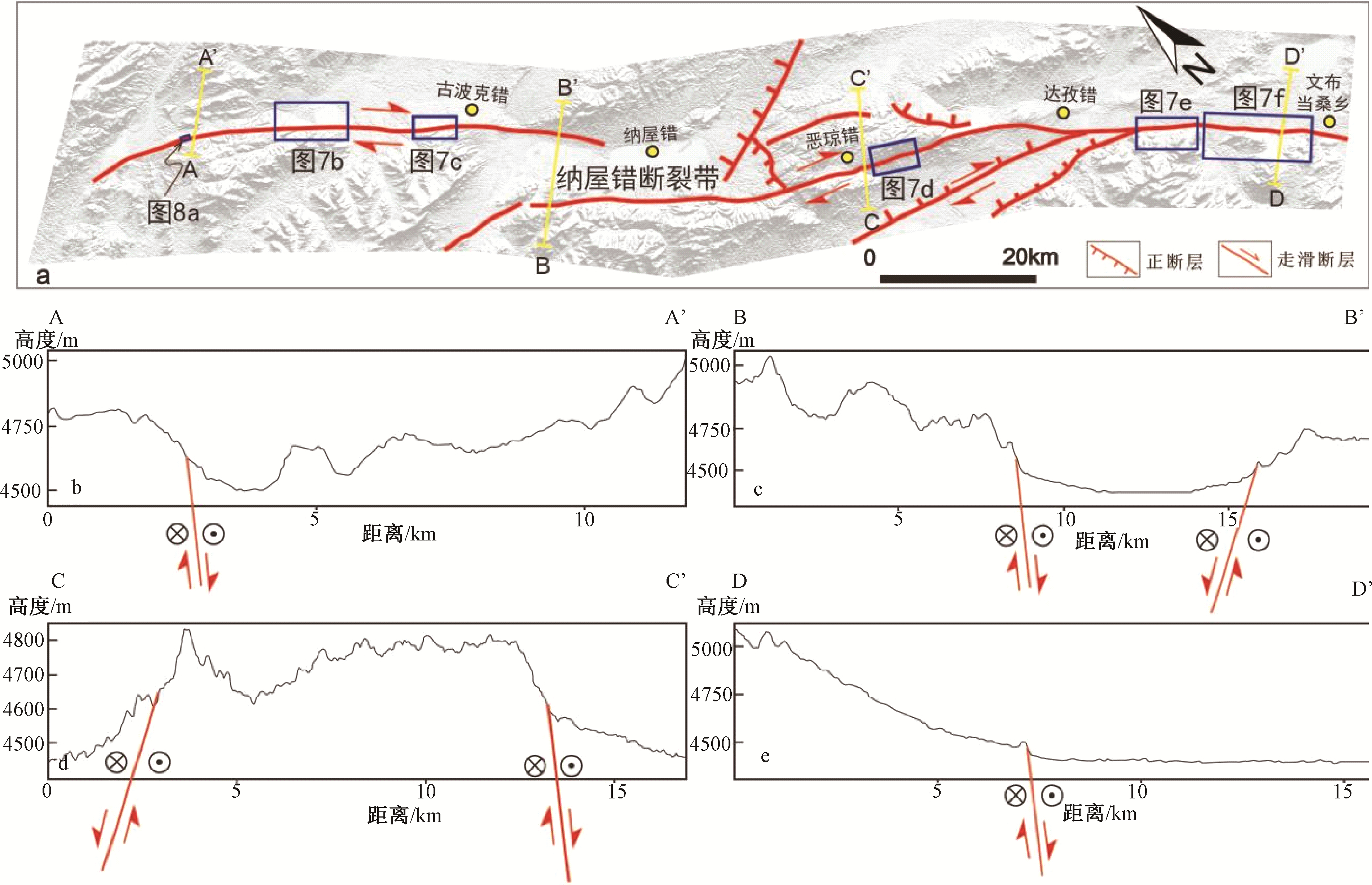
图 3 纳屋错断裂带展布特征及不同部位跨断裂带高程剖面图
a—纳屋错断裂带分支断裂与次级断裂展布;b—e—不同部位跨断裂带高程剖面地貌特征(断层产状依据断层地貌和现今应力场环境)
Figure 3. Distribution characteristics of the Lamu Co fault zone and elevation profiles of different parts crossing the fault zone
(a) Distribution of branch faults and secondary faults along the Lamu Co fault zone; (b-e)Topographic features of elevation profile of different parts crossing the fault zone (The fault geometry is determined based on the fault topography and the current stress field environment)

图 4 布木错断裂带和地表破裂带典型遥感影像图
a—地表破裂带西段线性特征;b—Q3-4扇体上发育地表破裂带陡坎;c—断层左旋错动水系;d—断层陡坡分隔第四纪沉积与基岩;e—地表破裂带东段未错段水系;f—地表破裂带东段以正断活动为主
Figure 4. Typical remote sensing images of the Bue Co fault zone and surface ruptures
(a)Linear characteristics of the west section of the surface rupture zone; (b) Fault scarp of surface rupture developed on the Q3-4 fans; (c) Left-lateral drainage offset by fault; (d) Quaternary sediments and bedrock separated by fault slope; (e) Water systems not offset by the eastern section of the surface rupture; (f) Surface rupture zone dominated by positive fault activity in the eastern section

图 5 布木错断裂带地表破裂带构造地貌特征(位置见图 4b)
a—布木错断裂带西段拉分盆地与T3阶地上断坡(镜向北东东);b—布木错断裂带T2阶地上断坡(镜向南东);c—布木错断裂带地表破裂T1阶地上断坡(镜向北东东);d—布木错断裂带地表破裂T0阶地上冲沟左旋(镜向南东);e—布木错断裂带地表破裂T1阶地上冲沟左旋(镜向南东);f—布木错断裂带地表破裂T1阶地上地震鼓包(镜向南东)
Figure 5. Structural geomorphic features of the Bue Co fault coseismic surface rupture (The location refers to Fig. 4b)
(a)Pull-apart basin in the western part of the Bue Co fault zone and fault slope on the T3 terrace (towards NEE); (b) Fault slope on the T2 terrace of the Bue Co fault zone (towards SE); (c) Fault slope on the T1 terrace of the Bue Co fault surface rupture (towards NEE); (d) Sinistral displacement of the gully on the T0 terrace of the Bue Co fault surface rupture (towards SE); (e) Sinistral displacement of the gully on the T1 terrace of the Bue Co fault surface rupture (towards SE); (f) Earthquake bulge on the T1 terrace of the Bue Co fault surface rupture (towards SE)

图 6 布木错地表破裂带无人机测图
a—布木错地表破裂带无人机高分辨率DSM影像;b、c—无人机高分辨率DSM影像上测量冲沟左旋位移
Figure 6. UAV photogrammetry of the Bue Co fault coseismic surface rupture
(a)High-resolution DSM image of the Bue Co fault surface rupture obtained by UAV; (b, c) Sinistral displacements of gullies measured on high-resolution DSM images obtained by UAV

图 7 纳屋错断裂带和地表破裂带典型遥感影像图
a—纳屋错走滑断裂带北支穿过第四纪晚期冲洪积扇及其上同震地表破裂;b—沿断裂北支地表破裂展布的晚更新世以来的冲洪积扇群;c—错不杂东南基岩与第四纪沉积以断层为界;d—多条水系沿纳屋错断层南支发生偏转;e—纳屋错断裂带东南段在第四纪湖区发育;f—纳屋错断裂带东南尾端活动痕迹变弱
Figure 7. Typical remote sensing image of the Lamu Co fault zone and surface rupture zone
(a)Late Quaternary alluvial fan offset by the northern branch of the Lamu Co strike-slip fault zone and co-seismic surface rupture on the fan; (b) The alluvial fan group since the late Pleistocene distributed along the surface rupture of the northern fault branch; (c) Bedrock and Quaternary deposits bounded by fault to the southeast of Cobuza; (d) Several drainage systems deflected along the southern branch of the Lamu Co fault; (e) The southeast section of the Lamu Co fault zone developed in the Quaternary lake region; (f) Diminishing activity traces at the southeast end of the Lamu Co fault zone

图 8 纳屋错断裂带地表破裂带野外构造地貌特征(位置见图 7a)
a—纳屋错断裂带地表破裂陡坎(镜向南东);b—纳屋错断裂带断层角砾岩(镜向北东);c—纳屋错断裂带位于山麓的断层陡坎(镜向北);d—纳屋错断裂带地表破裂造成冲沟右旋(镜向北东)
Figure 8. Structural geomorphic features of the Lamu Co fault zone coseismic surface rupture in the field (The location refers to Fig. 7a)
(a)Fault scarp of the Lamu Co fault surface rupture (towards SE); (b) Fault breccia of the Lamu Co fault zone (towards NE); (c) Fault scarp of the Lamu Co fault surface rupture located at the foothills The Lamu Co (towards N); (d) Dextral displacement of the gully induced by the Lamu Co fault surface rupture (towards NE)

图 9 纳屋错地表破裂带无人机测图
a—纳屋错地表破裂带无人机高分辨率DSM影像;b—d—无人机高分辨率DSM影像上测量冲沟右旋位移
Figure 9. UAV photogrammetry of the Lamu Co fault coseismic surface rupture
(a)High-resolution DSM image of the Lamu Co fault surface rupture obtained by UAV; (b-d) Dextral displacements of gullies measured on high-resolution DSM images obtained by UAV
表 1 布木错断裂系位移量分布表
Table 1. Statistic table of displacement in the Bue Co fault system
断裂名称 经度 纬度 断错标志 位移量/m 误差/m 布木错断裂 81°29′55.14″ 33°15′50.10″ 冲沟左旋 11.0 0.5 81°29′52.02″ 33°15′40.44″ 冲沟左旋 3.7 0.2 81°29′35.71″ 33°14′59.25″ 沟壁左旋 43.0 3.0 81°29′51.82″ 33°15′40.52″ 小沟左旋 4.2 0.3 81°29′54.82″ 33°15′50.25″ 小沟左旋 4.5 0.4 81°29′54.58″ 33°15′50.25″ 小沟左旋 6.4 0.6 纳屋错断裂 81°43′41.52″ 33°13′16.02″ 深沟右旋 7.3 1.2 81°43′31.62″ 33°13′20.10″ 小溪右旋 4.5 0.5 81°43′32.78″ 33°13′19.41″ 小溪右旋 2.7 0.3 81°43′33.49″ 33°13′19.10″ 冲沟右旋 13.7 1.1 81°43′40.51″ 33°13′16.28″ 小溪右旋 8.3 2.0 81°43′41.61″ 33°13′15.70″ 沟壁右旋 10.3 2.4 81°43′44.41″ 33°13′14.21″ 沟壁右旋 27.0 3.0 81°43′45.32″ 33°13′13.85″ 沟壁右旋 15.0 1.5 81°43′45.66″ 33°13′13.58″ 深沟右旋 14.0 1.5  下载: 导出CSV
-
ARMIJO R, TAPPONNIER P, MERCIER J L, et al., 1986. Quaternary extension in southern Tibet: Field observations and tectonic implications[J]. Journal of Geophysical Research: Solid Earth, 91(B14): 13803-13872. ARMIJO R, TAPPONNIER P, HAN T L, 1989. Late Cenozoic right-lateral strike-slip faulting in southern Tibet[J]. Journal of Geophysical Research: Solid Earth, 94(B3): 2787-2838. BAI M K, CHEVALIER M L, PAN J W, et al., 2018. Southeastward increase of the late Quaternary slip-rate of the Xianshuihe fault, eastern Tibet. Geodynamic and seismic hazard implications[J]. Earth and Planetary Science Letters, 485: 19-31. CHEN Q Z, FREYMUELLER J T, WANG Q, et al., 2004. A deforming block model for the present-day tectonics of Tibet[J]. Journal of Geophysical Research: Solid Earth, 109(B1): B01403, doi: 10.1029/2002JB002151. CHEVALIER M L, TAPPONNIER P, VAN DER WOERD J, et al., 2012. Spatially constant slip rate along the southern segment of the Karakorum fault since 200ka[J]. Tectonophysics, 530-531: 152-179. CHEVALIER M L, VAN DER WOERD J, TAPPONNIER P, et al., 2016. Late Quaternary slip-rate along the central Bangong-Chaxikang segment of the Karakorum fault, western Tibet[J]. GSA Bulletin, 128(1-2): 284-314. CLARK M K, ROYDEN L H, 2000. Topographic ooze: Building the eastern margin of Tibet by lower crustal flow[J]. Geology, 28(8): 703-706. doi: 10.1130/0091-7613(2000)28<703:TOBTEM>2.0.CO;2 ELLIOTT J R, WALTERS R J, ENGLAND P C, et al., 2010. Extension on the Tibetan plateau: recent normal faulting measured by InSAR and body wave seismology[J]. Geophysical Journal International, 183(2): 503-535. doi: 10.1111/j.1365-246X.2010.04754.x ENGLAND P, HOUSEMAN G, 1989. Extension during continental convergence, with application to the Tibetan Plateau[J]. Journal of Geophysical Research: Solid Earth, 94(B12): 17561-17579. doi: 10.1029/JB094iB12p17561 GAN W J, ZHANG P Z, SHEN Z K, et al., 2007. Present-day crustal motion within the Tibetan Plateau inferred from GPS measurements[J]. Journal of Geophysical Research: Solid Earth, 112(B8): B08416. GAO Y P, LIU J, HAN L F, et al., 2023. Discussion on the magnitude or intensity limitation of paleoearthquake events[J]. Journal of Geomechanics, 29(5): 704-719. (in Chinese with English abstract) GARTHWAITE M C, Wang H and Wright T J, 2013. Broadscale interseismic deformation and fault slip rates in the central Tibetan Plateau observed using InSAR. Journal of Geophysical Research: Solid Earth 118: 5071-5083. HAN M M, CHEN L C, ZENG D, et al., 2022. Discussion on the latest surface ruptures near the Zhonggu village along the Selaha segment of the Xianshuihe fault zone[J]. Journal of Geomechanics, 28(6): 969-980. (in Chinese with English abstract) HAN S, LI H B, PAN J W, et al., 2019. Co-seismic surface ruptures in Qiangtang Terrane: Insight into Late Cenozoic deformation of central Tibet[J]. Tectonophysics, 750: 359-378. HARRISON T M, COPELAND P, KIDD W S F, et al., 1992. Raising Tibet[J]. Science, 255(5052): 1663-1670. LIU F C, PAN J W, LI H B, et al., 2022. Characteristics of Quaternary Activities along the Riganpei Co Fault and Seismogenic Structure of the July 23, 2020 Mw6.4 Nima Earthquake, Central Tibet [J]. Acta Geoscientica Sinica, 43(2): 173-188. (in Chinese with English abstract) MÉRIAUX S A, TAPPONNIER P, RYERSON F J, et al., 2005. The Aksay segment of the northern Altyn Tagh fault: Tectonic geomorphology, landscape evolution, and Holocene slip rate[J]. Journal of Geophysical Research: Solid Earth, 110(B4): B04404. MEADE B J L, 2007. Present-day kinematics at the India-Asia collision zone[J]. Geology, 35(1): 81-84. MERCIER J L, ARMIJO R, TAPPONNIER P, et al., 1987. Change from late tertiary compression to quaternary extension in southern Tibet during the India-Asia Collision[J]. Tectonics, 6(3): 275-304. MOLNAR P, DAYEM K E, 2010. Major intracontinental strike-slip faults and contrasts in lithospheric strength[J]. Geosphere, 6(4): 444-467. MOLNAR P, TAPPONNIER P, 1975. Cenozoic tectonics of Asia: Effects of a continental collision: features of recent continental tectonics in Asia can be interpreted as results of the India-Eurasia collision[J]. Science, 189(4201): 419-426. MOLNAR P, TAPPONNIER P, 1978. Active tectonics of Tibet[J]. Journal of Geophysical Research: Solid Earth, 83(B11): 5361-5375. PAN G T, DING J, YAO D S, et al., 2004. The Qinghai-Tibet Plateau and its adjacent areas geological map 1 ∶ 150 million[M]. Chengdu: Chengdu Cartographic Publishing House: 1-140 (in Chinese). RATSCHBACHER L, KRUMREI I, BLUMENWITZ M, et al., 2011. Rifting and strike-slip shear in central Tibet and the geometry, age and kinematics of upper crustal extension in Tibet[J]. Geological Society, London, Special Publications, 353(1): 127-163. SHI X H, KIRBY E, LU H J, et al., 2014. Holocene slip rate along the Gyaring Co Fault, central Tibet[J]. Geophysical Research Letters, 41(16): 5829-5837. STYRON R, TAYLOR M, SUNDELL K, 2015. Accelerated extension of Tibet linked to the northward underthrusting of Indian crust[J]. Nature Geoscience, 8(2): 131-134. SUNDELL K E, TAYLOR M H, STYRON R H, et al., 2013. Evidence for constriction and Pliocene acceleration of east-west extension in the North Lunggar rift region of west central Tibet[J]. Tectonics, 32(5): 1454-1479. TAPPONNIER P, MOLNAR P, 1976. Slip-line field theory and large-scale continental tectonics[J]. Nature, 264(5584): 319-324. TAPPONNIER P, MOLNAR P, 1977. Active faulting and tectonics in China[J]. Journal of Geophysical Research, 82(20): 2905-2930. TAPPONNIER P, RYERSON F J, VAN DER WOERD J, et al., 2001a. Long-term slip rates and characteristic slip: keys to active fault behaviour and earthquake hazard[J]. Comptes Rendus de l' Academie des Sciences-Series IIA-Earth and Planetary Science, 333(9): 483-494. TAPPONNIER P, XU Z Q, ROGER F, et al., 2001b. Oblique stepwise rise and growth of the Tibet Plateau[J]. Science, 294(5547): 1671-1677. TAYLOR M, YIN A, RYERSON F J, et al., 2003. Conjugate strike-slip faulting along the Bangong-Nujiang suture zone accommodates coeval east-west extension and north-south shortening in the interior of the Tibetan Plateau[J]. Tectonics, 22(4): 1044. TAYLOR M, PELTZER G, 2006. Current slip rates on conjugate strike-slip faults in central Tibet using synthetic aperture radar interferometry[J]. Journal of Geophysical Research: Solid Earth, 111(B12): B12402. TAYLOR M, YIN A, 2009. Active structures of the Himalayan-Tibetan orogen and their relationships to earthquake distribution, contemporary strain field, and Cenozoic volcanism[J]. Geosphere, 5(3): 199-214. TAYLOR M H, KAPP P A, HORTON B K, 2011. Basin response to active extension and strike‐slip deformation in the hinterland of the Tibetan Plateau[M]//BUSBY C, AZOR A. Tectonics of sedimentary basins: recent advances. Oxford: Blackwell Publishing Ltd: 445-460. VAN DER WOERD J, RYERSON F J, TAPPONNIER P, et al., 1998. Holocene left-slip rate determined by cosmogenic surface dating on the Xidatan segment of the Kunlun fault (Qinghai, China)[J]. Geology, 26(26): 695-698. VAN DER WOERD J, RYERSON F J, TAPPONNIER P, et al., 2000. Uniform slip-rate along the Kunlun Fault: Implications for seismic behaviour and large-scale tectonics[J]. Geophysical Research Letters, 27(16): 2353-2356. WANG D, YIN G M, WANG X L, et al., 2016. OSL dating of the late Quaternary slip rate on the Gyaring Co Fault in central Tibet[J]. Geochronometria, 43(1): 162-173. WELLS D L, COPPERSMITH K J, 1994. New empirical relationships among magnitude, rupture length, rupture width, rupture area, and surface displacement[J]. Bulletin of the seismological Society of America, 84(4): 974-1002. WU Z H, ZHAO X T, WU Z H, et al., 2006. Quaternary geology and faulting in the Damxung-Yangbajain Basin, Southern Tibet[J]. Journal of Geomechanics, 12(3): 305-316. (in Chinese with English abstract) WU Z H, ZHANG X D, HAN S, et al., 2022. Quaternary faulting and deformation mechanism of the western Qiangtang block in northern Ngari, Tibet[J]. Acta Geologica Sinica, 96(11): 3760-3783. (in Chinese with English abstract) YANG P X, CHEN Z W, ZHANG J, et al., 2012. The tension-shear of Gyaring Co Fault and the implication for dynamic model in South-central Tibet[J]. Chinese Journal of Geophysics, 55(10): 3285-3295. (in Chinese with English abstract) YIN A, KAPP P A, MURPHY M A, et al., 1999. Significant late Neogene east-west extension in northern Tibet[J]. Geology, 27(9): 787-790. YIN A, 2000. Mode of Cenozoic east-west extension in Tibet suggesting a common origin of rifts in Asia during the Indo-Asian collision[J]. Journal of Geophysical Research: Solid Earth, 105(B9): 21745-21759. YIN A, HARRISON T M, 2003. Geologic evolution of the Himalayan-Tibetan Orogen[J]. Annual Review of Earth and Planetary Sciences, 28: 211-280. YIN A, TAYLOR M H, 2011. Mechanics of V-shaped conjugate strike-slip faults and the corresponding continuum mode of continental deformation[J]. GSA Bulletin, 123(9-10): 1798-1821. ZHANG J J, DING L, 2003. East-west extension in Tibetan plateau and its significance to tectonic evolution[J]. Chinese Journal of Geology, 38(2): 179-189. (in Chinese with English abstract) ZHANG J J, WANG J M, WANG X X, et al., 2013. A new model for the Himalayan orogeny[J]. Chinese Journal of Geology, 48(2): 362-383. (in Chinese with English abstract) ZHANG P Z, SHEN Z K, WANG M, et al., 2004. Continuous deformation of the Tibetan Plateau from global positioning system data[J]. Geology, 32(9): 809-812. ZHAO G M, WU Z H, LIU J, 2020. The types, characteristics and mechanism of seismic migration[J]. Journal of Geomechanics, 26(1): 13-32. (in Chinese with English abstract) 高云鹏, 刘静, 韩龙飞, 等, 2023. 古地震事件震级或强度大小限定的讨论[J]. 地质力学学报, 29(5): 704-719. doi: 10.12090/j.issn.1006-6616.2023034 韩明明, 陈立春, 曾蒂, 等, 2022. 鲜水河断裂带色拉哈段中谷村一带的最新地表破裂讨论[J]. 地质力学学报, 28(6): 969-980. doi: 10.12090/j.issn.1006-6616.20222824 刘富财, 潘家伟, 李海兵, 等, 2022. 青藏高原中部日干配错断裂第四纪活动特征及2020年7月23日西藏尼玛MW 6.4地震发震构造分析[J]. 地球学报, 43(2): 173-188. https://www.cnki.com.cn/Article/CJFDTOTAL-DQXB202202004.htm 潘桂棠, 丁俊, 姚东生, 等, 2004. 青藏高原及邻区地质图(1 ∶ 1500000)说明书[M]. 成都: 成都地图出版社: 1-140. 吴中海, 赵希涛, 吴珍汉, 等, 2006. 西藏当雄-羊八井盆地的第四纪地质与断裂活动研究[J]. 地质力学学报, 12(3): 305-316. https://journal.geomech.ac.cn/article/id/3ec85626-b773-448f-a430-a308b533aadd 吴中海, 张旭东, 韩帅, 等, 2022. 西藏阿里北部羌塘地块内部的第四纪活动断层及其变形机制[J]. 地质学报, 96(11): 3760-3783. https://www.cnki.com.cn/Article/CJFDTOTAL-DZXE202211008.htm 杨攀新, 陈正位, 张俊, 等, 2012. 西藏中南部格仁错断裂张剪性质及其区域动力学意义[J]. 地球物理学报, 55(10): 3285-3295. https://www.cnki.com.cn/Article/CJFDTOTAL-DQWX201210012.htm 张进江, 丁林, 2003. 青藏高原东西向伸展及其地质意义[J]. 地质科学, 38(2): 179-189. https://www.cnki.com.cn/Article/CJFDTOTAL-DZKX200302005.htm 张进江, 王佳敏, 王晓先, 等, 2013. 喜马拉雅造山带造山模式探讨[J]. 地质科学, 48(2): 362-383. https://www.cnki.com.cn/Article/CJFDTOTAL-DZKX201302006.htm 赵根模, 吴中海, 刘杰, 2020. 地震迁移的类型, 特征及机制讨论[J]. 地质力学学报, 26(1): 13-32. doi: 10.12090/j.issn.1006-6616.2020.26.01.002 期刊类型引用(4)
1. 王晨旭,李西. 弧形构造带构造特征及其数值模拟分析——以红河断裂中南段为例. 地质力学学报. 2025(01): 39-60 .  本站查看
本站查看2. 江晨轶,潘家伟,张丽军,李海兵,孙知明,Marie-Luce Chevalier,刘富财,苏强. UAV SfM技术在活动构造研究中的应用——以青藏高原西北部龙木错断裂为例. 地质力学学报. 2024(02): 332-347 . 本站查看3. 吴中海,郑文俊,任俊杰,任治坤. 活动构造与强震:专辑序言. 地质力学学报. 2024(02): 181-188 . 本站查看4. 柏伟国,孙东霞,吴中海,张耀玲,韩帅,贡秋卓玛. 西藏自治区1949—2020年历史地震灾害调查概要. 地震科学进展. 2024(10): 712-720 .  百度学术
百度学术其他类型引用(0)
-


 下载:
下载:


 下载:
下载:
 百度学术
百度学术
计量
- 文章访问数: 2586
- HTML全文浏览量: 574
- PDF下载量: 683
- 被引次数: 4
