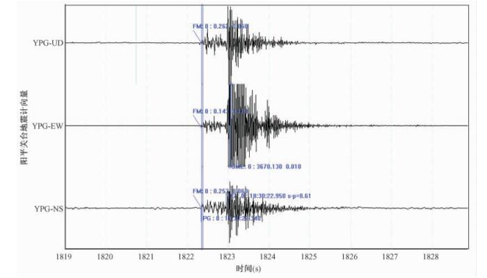
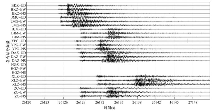
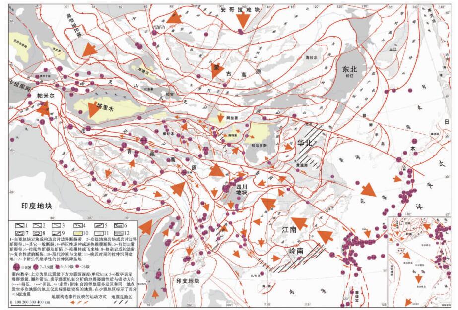
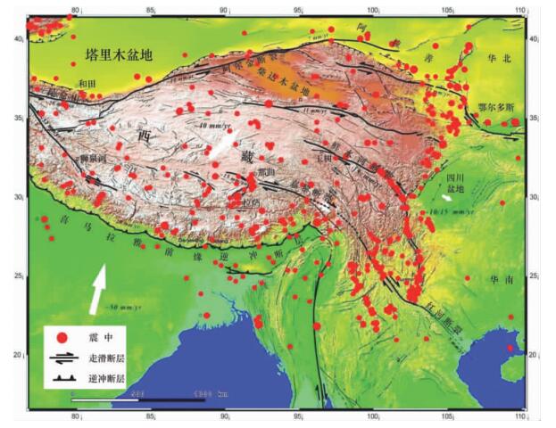
2011 Vol. 17, No. 1

Display Method:
STRAIN CHARACTERISTICS OF WFSD STRESS STATIONS AND ITS CO-SEISMIC EFFECTS ANALYSIS: A CASE STUDY UPON MW 9.0 EARTHQUAKE IN JAPAN
PENG Hua, MA Xiu-min, JIANG Jing-jie, PENG Li-guo
2011, 17(1): 1-14.
Abstract (127) HTML (83) PDF (1317KB)(7)
Abstract:
The MW 9.0 earthquake occurred in the northeastern Sea of Japan, on March 11, 2011.The volume strain meter in Wenchuan earthquake Fault Scientific Drilling (WFSD) recorded a complete response waveform at Hanzhong Prefecture, Shaanxi Province.By analyzing acquired data, some issues are studied and discussed by authors that including co-seismic changes of the whole process of MW 9.0 mega-earthquake in Japan, the abnormal strain changes of solid tide prior to that earthquake and after, and the emerging process of that earthquake.Per this paper, the strain anomalies of the MW 9.0 earthquake in Japan are analyzed in order to contribute to better forecast earthquake trends in China the future.
METHOD EXPLORING OF THE RESIDUAL FRICTION THERMAL ANOMALY MEASUREMENT: A CASE STUDY ABOUT THE TEMPERATURE MEASUREMENT IN WFSD-1
LI Zhen, PENG Hua, MA Xiu-min, JIANG Jing-jie
2011, 17(1): 15-26.
Abstract (200) HTML (113) PDF (758KB)(28)
Abstract:
In WFSD-1 borehole of the Wenchuan earthquake fault scientific drilling project, we conducted relative temperature gradient high-precision measurements and obtained large numbers of field data. In this paper, the friction residual heat temperature measuring method is discussed in detail and the position of Wenchuan earthquake fault zone is detected after field datum analyzing. We found three temperature anomalies in 400~500 m, 580~610 m and 620~750 m, respectively. Take geological data into comprehensive account, the two section's temperature anomalies may be caused by discrepancy of thermal conductivity in 400~500 m and 620~750 m and they aren't the residual frictional thermal anomalies. The section of the anomaly from nonpermeable fault clay in interval of 580~610 m may be resulted from friction heat generation during Wenchuan earthquake, and it located in the primary slip fault zone.
ANALYSIS UPON DYNAMIC RANGE AND MONITORING CAPABILITY OF WFSD DIGITAL SEISMIC NETWORK OF THE LONGMENSHAN FAULT ZONE
MA Xiu-min, PENG Hua, JIANG Jing-jie, PENG Li-guov
2011, 17(1): 27-40.
Abstract (190) HTML (64) PDF (1305KB)(7)
Abstract:
After the 5.12 earthquake in Wenchuan, the temporary digital seismic network has been layout in time in Longmenshan fault zone in order to monitor earthquake trends and probe into the large-scale tectonic stress field activity. Digital seismic network is made of 11 digital seismic instruments, and which are arranged at north eastern margin and southwestern side of Longmenshan fault zone. A certain number of data from observation stations are randomly selected in order to analyze the monitoring capability and dynamic range of WFSD digital seismic network. The dynamic noises of station base are acquired through the Fourier Transform and power spectral density analysis. And then, the dynamic range of observing systems and monitoring capacity of network are analyzed. WFSD digital seismic network has a monitoring ML1.5 micro-seismic capacity in Longmenshan fault zone based on Comparing the computing results with the record of a large number of micro-seismic. And it basically accorded with the results of that by Seismological Bureau Networks Center of China. Therefore, WFSD digital seismic network can provide a basic observing datum for the deformation mechanism research of Longmenshan fault zone.
REMOTE SENSING STRUCTURE ANALYSIS ON THE STRUCTURAL PROCESSES OF WENCHUAN AND YUSHU EARTHQUAKES: ANALYSIS OF AREA DANGEROUS OF EARTHQUAKE
LI Fang-quan
2011, 17(1): 41-54, 78.
Abstract (157) HTML (84) PDF (987KB)(9)
Abstract:
The earthquake is an deformation and displace of enveloping rock in crust. A succession earthquake in the same belt represents some diastrophism (crustal movement). viz. an earthquake is a "Seismic-Structural Event". The dangerous of seismic area in China for the past 20 years were predicted tentatively on the basis of "Seismic-Structural Event"analysis by using remote sensing. The dangerous of seismic area in eastern china for coming 5-10 years are forecasted in this paper through iterative verification. A violent earthquake probably occurs in littoral areas of GuangdongGuangxi and the middle part of north China plain area.
ANALYSIS AND THINKINGS ABOUT THE ORIGIN AND BACKGROUND OF 2010 YUSHU EARTHQUAKE
GE Xiao-hong, WANG Min-pei
2011, 17(1): 55-63.
Abstract (184) HTML (96) PDF (1140KB)(9)
Abstract:
The 2010 Yushu earthquake, originated in Qinghai, struck on April 14, 2010, and registered a magnitude of MS 7.1. This paper discusses the origin and background of the earthquake and gives some advices about post-disaster reconstruction. Considering the geotectonic settings, the authors attributes the origin of 2008 Wenchuan earthquake and 2010 Yushu earthquake to the Indian plate' s wedging in Qinghai-Tibet Plateau, which driving the material of curst-mantle under QinghaiTibet Plateau creeping to east and then caused the earthquakes. The Qinghai-Tibet Plateau consists of several different blocks, they were collaged together in Mesozoic and Cenozoic. The movement and collision of these blocks extruded by the Indian plate are the main reasons of those earthquakes around Qinghai-Tibet Plateau in last several years. Just because the eastward movement of Kunlun block leading to the sinistral slip of Yushu-Xianshuihe Fault, then caused the 2010 Yushu earthquake. Until now, the eastward movement of Kunlun block had caused three earthquakes with the magnitude of MS 7 to MS 8, massive accumulated energy had been released. So, the emphasis should be focused on the southeastward moving Qiangtang-Litang block and a strict surveillance must be kept on it. Learned from 2008 Wenchuan earthquake, the region with less movement by GPS always tend to be a center of energy accumulating because the block is resisted by other hard blocks, and is likely to be the region where earthquake will strike. The authors proposed that the following areas could be struck by earthquakes: Yuxi, Tonghai and Shiping areas in the south of Kunming; Dali area; Yanyuan and Yantang areas of western Sichuan Province; Ya' an, Luding and Kangding areas, which are the cross section of Yushu-Xianshuihe Fault and Longmen Mountain Fault. All of the four areas locate on the frontier of southward arciform thrust-nappe structure zones formed in late Cenozoic, and they likely to be the stress concentration regions when obstructing the movement of Qiangtang-Litang block. High attention with dynamic monitoring should be paid to in these areas suggested.
APPLICATION OF THE ETA-TYPE TECTONIC SERIES SUGGESTED BY LI SI-GUANG TO EARTHQUAKE PREDICTION
XU Dao-yi, SUN Wen-peng
2011, 17(1): 64-73.
Abstract (149) HTML (142) PDF (304KB)(9)
Abstract:
The eta-type tectonic system was suggested by academician Li Si-guan more than 70 years ago, and two great eta-type tectonic systems have been described by him: one is located in Qinhai-Xizang (Tibet) -Yunan-Burma-Indonesia (QXYBI), and the another is Western part of North America (WNA). Recently they have been applied to the earthquake prediction successfully. In this paper a brief introduction is concerned to the prediction of MS 8.3 Wenchuan Earthquake occurred on May 12th, 2008 by Huang Xiang-ning based on the QXYBI eta-type tectonic system, and also to the prediction of MS7.5 Mexico earthquake occurred on April 5th, 2010 by author according to the WNA eta-type tectonic system. The time intervals (about 53 ~ 54 years) among super-great earthquakes occurred in the same eta-type tectonic system demonstrate clear orderliness related to 3 times of astronomical Saros Period. Thus, it is clear that the modern seismic activity of eta-type tectonic systems is stimulated by the astronomical factors, and this character is favorable for the prediction of great earthquake in future.
DEVELOPING LI SIGUANG'S SCIENTIFIC THOUGHT ON EARTHQ
LI Fang-quan
2011, 17(1): 74-78.
Abstract (122) HTML (69) PDF (105KB)(12)
Abstract:
Some useful viewpoints on earthquake forecasting, based on Prof. Li Siguang 's important speeches and instructions, are presented in this paper in combination with authors'own experience and understanding. Those can be summarized in the four aspects as follows. The existence and change of earth stress has close relation with earthquake. Relatively safe areas may occur in active earthquake zones. Earthquake survey must be the basis of earthquake forecasting. Earthquake is predictable and the change process of earth stress is the key for earthquake forecasting. Professor Li Siguang's theory of "Safe Island" and the thought on earthquake forecast is of great significance both theoretically and realistically, which are the precious assets he left to us and worthy of further consideration, research and implementation so far.
NEW RESULTS AND MAJOR PROGRESSES IN REGIONAL SURVEY OF THE DARLAG-JIGZHI SHEETS
YANG Xin-de, YAN Xi-li
2011, 17(1): 79-90.
Abstract (131) HTML (81) PDF (1152KB)(9)
Abstract:
The major progress and achievements obtained in the geological survey within the extent of the 1: 250000 Darlag and Jigzhi Sheets include: 1) Established the stratigraphical framework of the Bayan har Group and made a detailed analysis of the basin sedimentary filling sequences and the tectonic setting discrimination. 2) Summarized the major types of basic sequences. 3) The depositional cycles and sea level variations of the Bayan har Basin are as same as that of southern Tibet and the Salt Range of Pakistan. 4) The deep water tempestite was recently discovered in Triassic flysch sediments. 5) The old age information of zircons from the Triassic granitoids shows that exists a "rigid basement" under the Bayan har Basin. 6) Three tenacity brittleness shearing belt have been discovered in this area; the uplift history of Qinghai-Tibet Plateau is discussed; made a detailed environmental geology study on the Project of South-North Water Transfer.
SEDEX DEPOSIT GENESIS OF THE Pb-Zn DEPOSITS IN THE NORTHEASTERN MARGIN OF LANPING BASIN IN YUNAN: EVIDENCE FROM MINERALOGICAL AND SULFUR ISOTOPIC STUDIES
HUANG Yu-feng, CAO Dian-hua, WANG Zhi-jun, LI Yi-ke, WANG An-jian
2011, 17(1): 91-102.
Abstract (166) HTML (72) PDF (977KB)(4)
Abstract:
A series of lead-zinc deposits such as Qingdianwan, Caizidi, Jinshantao and so on, which are situated in the Upper Triassic Shizhongshan Formation (T3s) at the Weixi-Qiaohou fault belt, northeast of Lanping Basin. The genesis studies of these lead-zinc deposits are relatively superficial.. In this paper, through detailed field geological survey and studies under the microscope, authors found a large number of typical signs of the synsedimentary deposit such as laminated structure, striped band structure, vein net structure, the soft sedimentary pyrite band structure, strawberry-like pyrite structure, colloidal structure of pyrite, sphalerite concentric structure etc. Sulfur isotopes analysis results of metal sulfide in Qingdianwan deposit are following: δ34 S of pyrite at 3.7‰ ~ 8.1‰, average 5.34‰ (N = 5); δ34 S of sphalerite at 5.2‰ ~ 10‰, average 7.18‰ (N = 5); δ34 S of galena at 5.2‰ ~ 9.9‰, average 7.275‰ (N = 4). It demonstrates that S in the deposit come from deoxidize of sulfate radical in seawater. Combining to the age data of these deposits and the tectonic background, we think these deposits in this area are pertain to Sedimentary Exhalation (SEDEX) genesis which revised the previous viewpoint that these deposits simply controlled by structure.
ENVIROMENTAL CHANGES RECORDED BY POLLEN SINCE MID TO LATE HOLOCENE IN HUITENGXILE LAKE, LNNER MONGOLIA
ZHAO Zhi-li, WANG Yong, CHI Zhen-qing, GUAN You-yi, YAO Pei-yi
2011, 17(1): 103-110.
Abstract (157) HTML (81) PDF (400KB)(26)
Abstract:
Sedimentary features and sporopollen assemblages from Huitengxile Lake located in central Inner Mongolia Autonomous Region were used to reconstruct the processes of climatic and environmental changes during mid to late Holocene. The results showed that the climate on the whole shifted from warm and humid to cold and arid over the last 5390 a, and that could be divided into 5 stages in detail: ① from 5390 a to 3970 a, the climate was warm and humid; ② from 3970 a to 3300 a, the climate was moderate and humid; ③ from 3300 a to 2380 a, the obvious drop of A/C ratio indicated the end of Megathermal, the climate was cool and arid; ④ from 2380 a to 1160 a, the climate varied to cool and humid, which was a special humid period after Megathermal. ⑤ Since 1160 a, it has been mild cool and arid.