

GLOBAL CLIMATE CHANGE AND GEOLOGICAL DISASTER RESPONSE ANALYSIS
-
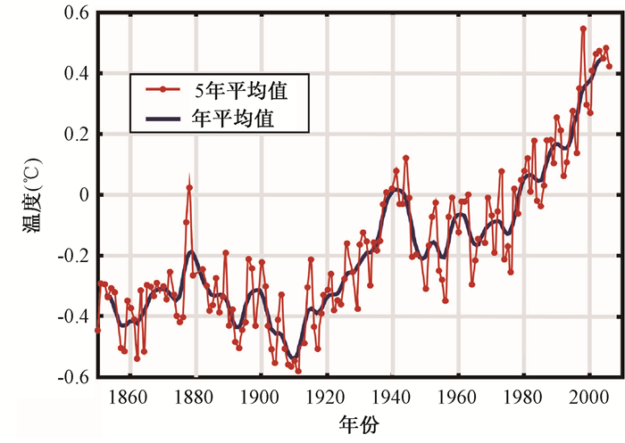
摘要: 对全球气候变化对地质灾害的响应关系,尤其是对滑坡和泥石流灾害的响应关系进行了综述。工业化革命以来,特别是近几十年来全球气候发生着重要的变化,全球几乎所有地区都经历着升温过程。全球气候变化对极端天气事件(极端降雨、气温升高、强风和洪水灾害)的影响尤为强烈,并且增加了地质灾害的发生风险。其中,水循环和气温的变化是影响地质灾害发生的直接因素。气温上升会导致大气层含水量升高、冰川冻土退化、海平面上升、蒸发作用增强;水循环变化会导致降雨频率、降水周期、降水强度的改变。日益增加的极端天气与同岩土体相互作用,导致了不同类型地质灾害的发生,严重威胁着人类的生活起居。Abstract: Since the industrial revolution, due to the global climate change, the world is experiencing global warming in recent decades. The impact of global climate change on extreme weather events (extreme rainfall, high temperatures, strong winds and floods) is particularly strong, and increases the risk of geological disasters. Water cycle and temperature change are the direct factors incuring geological disasters. The rise of temperature leads to the increase of water content in the atmosphere, the glacier permafrost degradation, sea-level rise, and evaporation enhancement. The change of water cycle will lead to changes in the frequency of rainfall, the cycle of precipitation, and the intensity of precipitation. Increasing extreme weather and soil interact lead to the occurrence of different types of geological disasters, which are serious threats to human life. In this paper, the response to geological disasters under global climate change, especially landslide and debris flow disasters, and the mutual relations are reviewed.
-
[1] OBERTHUR S. & OTY H E. The Kyoto Protocol: International Climate Policy for The 21st Century (International and European Environmental Policy Series)[J]. Springer, 1999: 359. [2] FIGUEIRO A S. & COELHO NETTO A L. Climaticvariability and pluviometrictrends in a humid tropical environmentat Resende municipality-middle Paraíba do Sul rivervalley (Rio de Janeiro-Brazil)[J]. Brazilian Geographical Journal: Geosciences and Humanities research medium, 2011, 2 (2): 256~273. [3] JENKINS G J, PERRY M. & PRIOR J: The Climate of the United Kingdom and Recent Trends. Hadley Centre, Met Office, Exeter[J]. UK:2009: available from:http://ukclimateprojections.defra.gov.uk. [4] JENKINS G J, MURPHY J M, SEXTON D M H, LOWE J A, JONES P and KILSBY C G. UK Climate Projections[J]. Briefing report. Met Office Hadley Centre, Exeter, UK, 2009, available from:http://ukclimateprojections.defra.gov.uk. [5] BRUNETTI M, BUFFONI L, MANGIANTI F, MAUGERI M. & NANNI T. Temperature, precipitation and extreme events during the last century in Italy[J]. Global and Planetary Change, 2004a, vol. 40: pp 141~149. doi: 10.1016/S0921~8181(03)00104~8 [6] BRUNETTI M, MAUGERI M, MONTI F. & NANNI T. Changes in daily precipitation frequency and distribution in Italy over the last 120 years[J]. Journal of Geophysical Research, 2004b, vol. 109: D05102. doi: 10.1029/2003JD004296. [7] TRENBERTH K. Changes in precipitation with climate change.Climate Research[J]. 2011, vol. 47: pp 123~138. [8] KOSTOPOULOU E. & JONES P D. Assessment of climate extremes in the eastern Mediterranean[J]. Meteorology and Atmospheric Physics, 2005, 89: 69~85. doi: 10.1007/s00703-005-0122~2 [9] SMITH T M, REYNOLDS R W. A global merged land and sea surface temperature reconstruction based on historical observations (1880~1997)[J]. Journal of Climate, 2005, 18: 2021~2036. doi: 10.1175/JCLI3362.1 [10] TRENBERTH K E, JONES P D, AMBENIE P, BOJARJU R, EASTERLING D, KLEIN TANK A, PARKER D, RAHIMZADEH F, RENWICK J A, RUSTICUCCI M, SODEN B, ZHAI P. Observations: Surface and Atmospheric Climate change. In: Solomon S, Qin, D, Manning M, Chen Z, Marquis M, Averyt, K B, Tignor M, Miller H L. (Eds.), Climate Change 2007, The Physical Science Basis, Contribution of Working Group Ⅰ to the Fourth Assessment Report of the Intergovernmental Panel on Climate Change[J]. Cambridge University Press, Cambridge, United Kingdom and New York, NY, USA, 2007: pp. 235~336. [11] WALSH J D, WUEBBLES K, HAYHOE J, KOSSIN K, KUNKEL G, STPHENS P, THORNE R, VOSE M, WEHNER J, WILLIS D, ANDERSON S, DONEV R, FEELY P, HENNON V, KHARIN T, KNUTSON F, LANDERER T, LENTON J, KENNEDY and R SOMERVILLE. Chapter 2: Our Changing Climate. Climate Change Impacts in the United States: The Third National Climate Assessment, In: Melillo, J.M., Richmond, T.C., Yohe, G.W. (Eds.), U.S[J]. Global Change Research Program, 2014:pp. 19~67. doi:10.7930/J0KW5CXT. [12] DIRMEVER P A and KINTER J L Ⅲ. The Maya Express—Late spring floods in the U.S. Midwest[J]. Eos, Transactions of the American Geophysical Union, 2009, 90: 101~102. doi: 10.1029/2009EO120001 [13] BUSH E J, LODER J W, JAMES T S, MORTSCH L D, COHEN S J. An Overview of Canada's Changing Climate; In Canada in a Changing Climate: Sector Perspectives on Impacts and Adaptation[J]. Eds.: F.J. Warren and D.S. Lemmen, Government of Canada, Ottawa, ON, 2014: 23~64. https://www.researchgate.net/publication/263368741_Bush_EJ_Loder_JW_James_TS_Mortsch_LD_and_Cohen_SJ_et_al_2014_An_Overview_of_Canada's_Changing_Climate_in_Canada_in_a_Changing_Climate_Sector_Perspectives_on_Impacts_and_Adaptation_ed_FJ_Warren_and_DS_ [14] CHURCH J A., CLARK P U., CAZENAVE A, GREGORY J M, JEVREJEVA S, LEVENMANN A, MERRIFIELD M A, MILNE G A, NEREM R S, NUNN P D, PAYNE A J, PFEFFER W T, STAMMER D, UNNIKRISHNAN A S. Sea Level Change. In: Climate Change 2013: The Physical Science Basis. Contribution of Working Group Ⅰ to the Fifth Assessment Report of the Intergovernmental Panel on Climate Change[J] Eds: T.F. Stocker, D. Qin, G K. Plattner, M. Tignor, S.K. Allen, J. Boschung, A. Nauels, Y. Xia, V. Bex, P.M. Midgley, Cambridge University Press, Cambridge, United Kingdom and New York, NY, USA. [15] YIN Y, CHENG Y, LIANG J et al. Heavy-rainfall-induced catastrophic rockslide-debris flow at Sanxicun, Dujiangyan, after the Wenchuan Ms 8.0 earthquake[J]. Landslides, 2015: 1~15. doi: 10.1007/s10346-015-0554~9 [16] IVERSON R M, GEOGE D L, ALLSTADT K, REID M R, COLLINS B D, VALLANCE J W, SCHILLING S P, GODT J W, CANNON C M, MAGIRL C S, BAUM R L, COE J A, SCHULZ W H, BOWER J B. Landslide mobility and hazards: broad implications of the Oso disaster[J]. Earth and42 Planetary Science Letters, 2015, 412: 197~208. doi: 10.1016/j.epsl.2014.12.020 [17] COE J A, KEAN J W, GODT J W, BAUM R L, JONES E S, GOCHIS D J, ANDERSON G S. New insights into debris-flow hazards from an extraordinary event in the Colorado Front Range[J]. GSA Today, 2014, 24: 4~10. http://www.geosociety.org/gsatoday/archive/24/10/abstract/i1052~5173~24~10~4.htm [18] COE J. Forensic Analysis of the May 2014 West Salt Creek Rock Avalanche in Western Colorado[C]. 2015 AGU Fall Meeting, Agu, 2015. [19] NBC NEWS. Final body found after deadly landslide in Sitka, Alaska[N] NBC News online article, August 25, 2015. [20] LUND W R, KNUDSEN T R, BOWMAN S D. Investigation of the December 12, 2013, fatal rock fall at 368 West Main Street, Rockville, Utah[J]. Utah Geological Survey Report of Investigation, 2014, 273: pp20. [21] ISHIZUKA T, OKAMOTO A. & NAKAGOMI J. Emergency structural and non-structural measures against secondary disasters by landslide dams in Kii Peninsula, Japan caused by typhoon Talas in 2011[J]. M. Chigira (Ed.), Characterization, Prediction, and Management of Deep-seated Catastrophic Landslides, Disaster Prevention Research Institute, Kyoto University, (2012): pp. 38~44. [22] COELHO NETTO, A L. Produça-o de Sedimentos em Bacias Fluviais Florestadas do Macia-o da Tijuca: respostas aos eventos extremos de fevereiro de 1996[J]. Anais do Ⅱ Encontro nacional de Engenharia de Sedimentos, 1996, 1: 209~217. [23] HUGGEL C, CLAGUE J J. & KORUP O. Is climate change responsible for changing landslide activity in high mountains[J]. Earth Surface Processes and Landforms, 2012, 37: 77~91. doi: 10.1002/esp.v37.1 [24] DYURGEROV M B, MEIER M F. Twentieth century climate change: evidence from small glaciers[J]. Proceedings of the National Academy of Sciences of the United States of America, 2000, 97: 1406~1411. doi: 10.1073/pnas.97.4.1406 [25] LUCKMAN B, KAVANAGH T. Impact of climate fluctuations on mountain environments in the Canadian Rockies[J]. Ambio, 2000, 29: 371~380. doi: 10.1579/0044~7447~29.7.371 [26] FRANCOU B, VUILLE M, WAGNON P, MENDOZA J, SICART J. Tropical climate change recorded by a glacier in the central Andes during the last decades of the twentieth century: Chacaltaya, Bolivia, 16°S[M]. Journal of Geophysical Research, 2003: 108, 4154. [27] KASER G, HARDY D R, MOLG T, BRADLEY R S, HYERA T M. Modern glacier retreat on Kilimanjaro as evidence of climate change: observations and facts[J]. International Journal of Climatology, 2004, 24: 329~339. doi: 10.1002/(ISSN)1097-0088 [28] BLAIR R W JR. Moraine and valley wall collapse due to rapid deglaciation in Mount Cook National Park, New Zealand[J]. Mountain Research and Development, 1994, 14: 347~358. doi: 10.2307/3673731 [29] GERTTSEMA M, CLAGUE J J, SCHWAB J W, EVANS S G. An overview of recent large catastrophic landslides in northern British Columbia, Canada[J]. Engineering Geology, 2006, 83: 120~143. doi: 10.1016/j.enggeo.2005.06.028 [30] HUGENHOLTZ C H, MOORMAN B J, BARLOW J, WAINSTEIN P A. Large-scale moraine deformation at the Athabasca glacier, Jasper National Park, Alberta, Canada[J]. Landslides, 2008, 5: 251~260. doi: 10.1007/s10346-008-0116~5 [31] FISCHER L, PURVES R S, HUGGEL C, NOETZLI J and HAEBERLI W. On the influence of topographic, geological and cryospheric factors on rock avalanches and rockfalls in high-mountain areas[J]. Natural Hazards and Earth System Sciences, 2012, 12: 241~254. doi: 10.5194/nhess~12~241~2012 [32] HAEBERLI W. Mountain permafrost-research frontiers and a special long-term challenge[J]. Cold Regions Science and Technology, 2013, 96: 71~76. doi: 10.1016/j.coldregions.2013.02.004 [33] REBETEZ M, LUGON R, BAERISWYL P A. Climatic change and debris flows in high mountain regions: the case study of the Ritigraben torrent (Swiss Alps)[J]. Climatic Change, 1997, 36: 371~389. doi: 10.1023/A:1005356130392 [34] CHIARLE M, IANNOTTI S, MORTARA G. & DELINE P. Recent debris flow occurrences associated with glaciers in the Alps[J]. Global and Planetary Change, 2007, vol. 56: pp 123~136. doi: 10.1016/j.gloplacha.2006.07.003 [35] LEGG N T, MEIGS A J, GRANT G E and KENNARD P. Debris flow initiation in proglacial gullies on Mount Rainier, Washington[J]. Geomorphology, 2014, 226: 249~260. doi: 10.1016/j.geomorph.2014.08.003 [36] LANCASTER S T, NOLIN A E, COPELAND E A, GRANT G E. Periglacial debris-flow initiation and susceptibility and glacier recession from imagery, airborne LiDAR, and ground-based mapping[J]. Geosphere 8, 2012: 417~430. http://geosphere.geoscienceworld.org/content/early/2012/03/06/GES00713.1 [37] BROWN J, FERRIANS O J JR, HEGINBOTTOM J A, MELNIKOV E S. Circum-arctic map of permafrost and ground-ice conditions[J]. Circum-Pacific Map CP~45, 1:10, 000, 000-scale, U.S. Geological Survey in Cooperation with the Circum-Pacific Council for Energy and Mineral Resources, Washington, D.C, 1997, 1 sheet. [38] NELSON F E, BRIGHAM L W, HINKEL K M, SMITH O, PARKER W, TUCKER W, ROMANOVSKY V E, VINSON T, SHIKLOMANOV N I, COLE D M, LEE W, KLENE A E, SAXTON A. Climate change, permafrost, and impacts on civil infrastructure. U.S[J]. Arctic Research Commission Permafrost Task Force Special Report 01-03, Arlington, Virginia, 2003: pp 62. http://citeseerx.ist.psu.edu/viewdoc/summary?doi=10.1.1.383.5664 [39] BROOKS S M. & SPENCER T. Shoreline retreat and sediment release in response to accelerating sea level rise: Measuring and modelling cliffline dynamics on the Suffolk Coast, UK[J]. Global and Planetary Change, 2012, 80~81:165~179. doi: 10.1016/j.gloplacha.2011.10.008 [40] Frechette J D, Meyer G A. Holocene fire-related alluvial-fan deposition and climate in ponderosa pine and mixed-conifer forests, Sacramento Mountains, New Mexico[J]. The Holocene 19, 2009: 639~651. [41] NOTT J F, THOMAS M F, PRICE D M.Alluvial fans, landslides and Late Quaternary climatic change in the wet tropics of northeast Queensland[J]. Australian Journal of Earth Sciences 48, 2001: 875~882. doi: 10.1046/j.1440-0952.2001.00906.x [42] BIGIO E, SWETNAM T W, BAISAN C H. A comparison and integration of tree-ring and alluvial records of fire history at the Missionary Ridge Fire, Durango, Colorado, USA[J]. The Holocene 20, 2010: 1047~1061. doi: 10.1177/0959683610369502 [43] RAHARDJO H, SATYANAGA A. & LEONG E C. Effects of Flux Boundary Conditions on Pore-water Pressure Distribution in Slope[J]. Journal of Engineering Geology, Special Issue on Unsaturated Soils: Theory and Applications, 2013a, Vol. 165: 133~142. https://dr.ntu.edu.sg/handle/10220/11306 [44] RAHARDJO H, SANTOSO V A, LEONG E C, NG Y S, TAM C P H AND SATYANAGA A. Use of Recycled Crushed Concrete and Secudrain in Capillary Barrier for Slope Stabilization[J]. Canadian Geotechnical Journal, 2013b, 50: 1~12. doi: 10.1139/cgj~2012-0057 [45] HEATH R C. & LEHR J H. A New Approach to The Disposal of Solidwaste on Land[J]. Ground Water, 1987, 25 (3): 258~264. doi: 10.1111/gwat.1987.25.issue~3 [46] MORRIS P H, GRAHAM J. & WILLIAMS D J. Cracking in Drying Soils[J]. Canadian Geotechnical Journal, 1992, 29(2): 263~277. doi: 10.1139/t92-030 [47] HEWITT P J. & PHILIP L K. Problems of Clay Desiccation in Composite Lining Systems[J]. Engineering Geology, 1999, 53(1): 107~113. http://www.sciencedirect.com/science/article/pii/S001379529900023X [48] KEEFER D K, WILSON R C, MARK R K, BRABB Ⅲ E E, ELLEN S D, HARP E L, WIECZOREK G F, ALGER C S, ZATKIN R S. Realtime landslide warning during heavy rainfall[J]. Science, 1987, 238 (13): 921~925. [49] WIECZOREK G F, SARMIENTO. Rainfall, peizometric levels, and debris flows near La Honda, California in storms between 1975 and 1983[J]. In: Ellen, S.D., Wieczorek, G.F. (Eds.), Landslides, Floods, and Marine Effects of the Storm of January 3~5, 1982, in the San Francisco Bay Region, California. U.S. Geological Survey Professional Paper, 1988, 1434: 43~62. [50] NEARY D G, SWIFT L W. Rainfall thresholds for triggering a debris avalanching event in the southern Appalachian Mountains[J]. Reviews in Engineering Geology, 1987, 7: 81~92. doi: 10.1130/REG7 [51] CAINE N. The rainfall intensity: duration control of shallow landslides and debris flows[J]. Geografiska Annaler. Series A. Physical Geography, 1980: 23~27. doi: 10.1007%2Fs10346-007-0112~1/fulltext.html [52] VARGAS M. & PICHLER E. Residual soil and rock slides in Santos, Brazil[J]. In Proc.4th Pan-AmericanConfon SMFE, 1957, 6 (27): 394~398. [53] COSTA NUNES A D. Landslides in soils of decomposed rock due to intense rainstorms[J]. In Proc. Ⅶernational conference on soil mechanics and foundation engineering, Mexico, 1969: pp. 547~554. [54] GUIDICINI G. & IWASA O Y. Tentative correlation between rainfall and landslides in a humid tropical environment[J]. Bulletin of the International Association of Engineering Geology-Bulletin de l'Association Internationale de Géologie de l'Ingénieur, 1977, 16 (1): 13~20. doi: 10.1007%2FBF02591434 [55] KANJI M A, MASSAD F. & CRUZ P T. Debris flows in areas of residual soils: occurrence and characteristics[J]. In International Workshop on Occurrence and Mechanism of Flows in Natural Slopes and Earthfills, 2003: pp 1~13. https://www.researchgate.net/publication/284534613_Debris_flows_in_areas_of_residual_soils_occurrence_and_characteristics_International_Workshop_on_Occurrence_and_Mechanisms_of_Flows_in_Natural_Slopes_and_Earthfills_Iw-Flows_2003_Sorrento [56] NIETO A S. & BARANY I. Interim report on catastrophic rain induced landslides in Rio de Janeiro and Petropolis, Brazil[J]. Report to Committee on Natural Disasters, National Research Council, Department of Geology, University of Illinois. Urbana, April. 1988. [57] DIXON N, BROOK E.Impact of predicted climate change on landslide reactivation: case study of Mam Tor, UK[J]. Landslides, 2007, 4: 137~147. doi: 10.1007/s10346-006-0071-y [58] WINTER M G, DENT J, MACGREGOR F, DEMPSEY P, MOTION A, SHACKMAN L. Debris flow, rainfall and climate change in Scotland[J]. Quarterly Journal of Engineering Geology and Hydrogeology, 2010, 43: 429~446. doi: 10.1144/1470~9236/08~108 [59] PICCARRETA M, CAPOLONGO D, MICCOLI M N. & BENTIVENGA M. Global change and long-term gully sediment production dynamics in Basilicata, southern Italy[J]. Environmental Earth Sciences, 2012, vol. 67: pp 1619~1630. doi: 10.1007/s12665-012~1603~5 [60] BRAND E W. Landslides in Southeast Asia: a state-of-the-art report[M]. Place of publication not identified, 1984. [61] CHURCH M, MILES M J. Meteorological antecedents to debris flow in southwestern British Columbia; some case studies[J]. Reviews in Engineering Geology, 1987, 7: 63~80. doi: 10.1130/REG7 [62] EL-HADJI I T. & SINGH V P. Space-time-frequency analysis of rainfall, runoff and temperature in the Casamance River basin, South Senegal, West Africa[J]. Water-South Africa, 2002, 28 (3): 4378~4738. http://www.oalib.com/paper/1349510 [63] MCSAVENEY M J, GRIFFITHS G A. Drought, rain, and movement of a recurrent earthflow complex in New Zealand[J]. Geology, 1987, 15 (7): 643~646. doi: 10.1130/0091~7613(1987)15<643:DRAMOA>2.0.CO;2 [64] JAEDICKE C, SOLHEIM A, BLIKRA L H, STALSBERG K, SORTEBERG A, AAHEIM A, KRONHOLM K., VIKHAMAR-SCHULER D, ISAKSEN K, SLETTEN K, KRISTENSEN K, BARSTAD I, MELCHIORRE C, HØYDAL Ø A., MESTL H. Spatial and temporal variations of Norwegian geohazards in a changing climate, the GeoExtreme project[J]. Natural Hazards and Earth System Sciences, 2008, 8: 893~904. doi: 10.5194/nhess~8~893~2008 [65] RAHARDJO H, SATYANAGA A, LEONG E C et al. Performance of an instrumented slope covered with shrubs and deep-rooted grass[J]. Soils and Foundations, 2014, 54 (3): 417~425. doi: 10.1016/j.sandf.2014.04.010 [66] SMETHURST J A, CLARKE D. & POWRIE W. Factors controlling the seasonal variation in soil water content and pore water pressures within a lightly vegetated clay slope[J]. Géotechnique, 2012, 62 (5): 429~446. doi: 10.1680/geot.10.P.097 [67] BRIGGS K, SMETHURST J & POWRIE W. Modelling the Influence of Tree Removal on Embankment Slope Hydrology. In Landslide Science for a Safer Geoenvironment[J]. Springer International Publishing, 2014: pp 241~246. doi: 10.1007/978~3~319-04999~1_32 [68] LUMB P. Slope failures in Hong Kong[J]. Quarterly Journal of Engineering Geology and Hydrogeology, 1975, 8 (1): 31~65. doi: 10.1144/GSL.QJEG.1975.008.01.02 [69] BUMA J. & DEHN M. A method for predicting the impact of climate change on slope stability[J]. Environ. Geol, 1998, 35 (1998): 190~196. http://cat.inist.fr/?aModele=afficheN&cpsidt=2424420 [70] HUTCHINSON M F. Interpolating mean rainfall using thin plate smoothing splines[J]. International journal of geographical information systems, 1995, 9 (4): 385~403. doi: 10.1080/02693799508902045 [71] WINTER M G, DENT J, MACGREGOR F, DEMPSEY P, MOTION A, SHACKMAN L. Debris flow, rainfall and climate change in Scotland[J]. Quarterly Journal of Engineering Geology and Hydrogeology, 2010, 43: 429~446. doi: 10.1144/1470~9236/08~108 [72] JAKOB M, LAMBERT S. Climate change effects on landslides along the southwest coast of British Columbia[J]. Geomorphology, 2009, 107 (3): 275~284. http://cat.inist.fr/?aModele=afficheN&cpsidt=21691110 [73] GUTHRIE R H, MITCHELL S J, LANQUAYE-OPOKU N, EVANS S G. Extreme weather and landslide initiation in coastal British Columbia[J]. Quarterly Journal of Engineering Geology and Hydrogeology 2010, 43 (4): 417~428. doi: 10.1144/1470~9236/08~119 [74] GEERTSEMA M. Quick clay landslides, landscape evolution, and climate change-a perspective from British Columbia[J]. In the Proceedings of the Second world Landslide Forum, Rome, 2011: 6. doi: 10.1007/978~3~642~31337-0_15/fulltext.html [75] XING A G, WANG G, YIN Y P et al. Dynamic analysis and field investigation of a fluidized landslide in Guanling, Guizhou, China[J]. Engineering Geology, 2014, 181: 1~14. doi: 10.1016/j.enggeo.2014.07.022 [76] NADIM F, SCHACK PEDERSEN S A, SCHMIDT-THOMé P, SIGMUNDSSON F, ENGDAH F. Natural hazards in Nordic countries[J]. Episodes, 2009a, Vol. 31, No. 1: pp 176~184. https://www.researchgate.net/publication/239610819_Natural_hazards_in_Nordic_Countries [77] COELHO NETTO A L C, SATO A M, AVELAR A S, VIANNA L G G, ARAúJO I S, FERREIRA D L. & SILVA R P. January 2011: The Extreme Landslide Disaster in Brazil[J]. In Landslide Science and Practice Springer Berlin Heidelberg, 2013: pp. 377~384. doi: 10.1007/978~3~642~31319~6_51/fulltext.html [78] ROUAINIA M, DAVIES O, O'BRIEN T. & GLENDINNING S. Numerical Modeling of Climate Effects on Slope Stability. Proc[J]. The Institution of Civil Engineers, Engineering Sustainability, 2009, 162 (ES2): pp.81~89. [79] KILSBY C, GLENDINNING S, HUGHES P N, PARKIN G. & BRANSBY M F. Climate-change impacts on long-term.performance of slopes[J]. Proc. of The Institution of Civil Engineers, Engineering Sustainability, 2009, 162 (ES2): pp.59~66. doi: 10.1680/ensu.2009.162.2.59 [80] ALONSO E E, GENS A. & DELAHAYE C H. Influence of rainfall on the deformation and stability of a slope in overconsolidated clays: a case study[J]. Hydrogeology Journal, 2003, Vol. 11:pp. 174~192. doi: 10.1007/s10040-002-0245~1 [81] LAMBECK K. Late Devensian and Holocene shorelines of the British Isles and North Sea from models of glacio-hydro-isostatic rebound[J]. Journal of the Geological Society-London, 1995, 152 (3): 437~448. doi: 10.1144/gsjgs.152.3.0437 [82] COROMINAS J. Litologías inestables. Monografíano 3. Sociedad Española de Geomorfología[J]. Zaragoza, 1989: pp.81~96. [83] ARAÑA V, BADIOLA E R, BERGA L et al. "Riesgos geológicos en España. Estado de la cuestión"[J]. Ⅲ Congreso Geológico de España y Ⅷ Congreso Latinoamericano de Geología, Tomo, 2: pp: 671~745. https://www.researchgate.net/publication/40933256_Riesgos_geologicos_en_Espana_estado_de_la_cuestion [84] DíAZ DE TERáN, J.R; CENDRERO A.; ARAÑA V; BADIOLA E R; BERGA L; CARRACEDO J C; CHACóN J; COELLO J; COROMINAS J; DABRIO C; DURáN J J; ELíZAGA E; FERRER M; GARCíA M.; GARZóN G; GONZáLEZ A; GOY J L; LóPEZ J; MARTíNEZ-GOYTRE J; MEZCUA J; NUEZ J. DE LA; SALINAS J L; SOLER V; VAL J DEL; & ZAZO C. Geomorphological Hazards in Spain[J]. In: Geomorphological hazards of Europe, (C. Embleton & Ch. Embleton-Hamann, eds), 1997, 56. [85] COROMINAS J. & BAEZA C. "Landslides in the Eastern Pyrenees-Spain". In M. del Prete (Ed): Movimenti franosie metodi di stabilizzazione. Consiglio Nazionale delle Ricerche. Pub. no 481[J]. Italia, 1992: pp. 25~42. [86] BERGANZA F AND MODRANO R. The instability phenomenon of the banks of the river Duero in its passage through Aranda (Burgos) in Tertiary soils[J]. 1978, Ⅲ International Congres IAEG. Sect. Ⅰ (1). Madrid: 197~208. [87] COROMINAS J. Landslides and Climate. In E.N. Bromhead (ed.)[J]. Ⅷ International Symposium on Landslides, Cardiff, UK, Keynote lectures, CD_ROM, 2000. [88] COROMINAS J, MOYA J AND HüRLIMANN M. Landslide rainfall triggers in the Spanish Eastern Pyrenees[J]. Proceedings 4th EGS Conference on Mediterranean Storms. Mallorca. CD-ROM, 2002. https://www.researchgate.net/publication/267966643_LANDSLIDE_RAINFALL_TRIGGERS_IN_THE_SPANISH_EASTERN_PYRENEES [89] GUZZETTI F, REICHENBACH P, CARDINALI M, GALLI M. & ARDIZZONE F. Probabilistic landslide hazard assessment at the basin scale[J]. Geomorphology, 2005a, 72 (1/4): 272~299. http://www.sciencedirect.com/science/article/pii/S0169555X05001911 [90] BONNARD CH. Los deslizamientos de tierra: Fenómeno natural o fenómeno inducido por el hombre. Proceedings 1st Panam. Symp on Landslides[J]. Guayaquil, Ecuador, 1994, 2: 1~15. [91] WUEBBLES D J, AND KUNKEL K., WEHNER M AND ZOBEL Z. Severe weather in United States under a changing climate[J]. EOS, Transactions, American Geophysical Union, 2014, 95 (no. 18): 149~150. doi: 10.1002/2014EO180001/pdf [92] JMA (Japan Meteorological Agency). Climate change monitoring report 2013, 2014. [93] NVE. Norwegian Water Resources and Energy Directorate. Landslides in Southern Norway May 2013. Jordskred i S-Norge mai 2013. 2014, Rapport nr 52~2014. [94] 殷跃平.斜倾厚层山体滑坡视向滑动机制研究[J].岩石力学与工程学报, 2010, 29 (2). http://cdmd.cnki.com.cn/Article/CDMD~82501~1012371283.htmYin Yue-ping. Study on the sliding mechanism of the inclined thick layer landslide[J]. Journal Of Rock Mechanics And Engineering, 2010, 29 (2). http://cdmd.cnki.com.cn/Article/CDMD~82501~1012371283.htm [95] 冯振, 殷跃平, 李滨, 等.斜倾厚层岩质滑坡视向滑动的土工离心模型试验[J].岩石力学与工程学报, 2012, 31 (5): 890~897. http://www.cnki.com.cn/Article/CJFDTOTAL-YSLX201205005.htmFeng Zhen, Yin Yue-ping, Li Bin, et al. The centrifugal model test of the visual sliding of the inclined thick layered rock slope[J]. Journal Of Rock Mechanics And Engineering, 2012, 31 (5): 890~897. http://www.cnki.com.cn/Article/CJFDTOTAL-YSLX201205005.htm [96] 殷跃平, 朱继良, 杨胜元.贵州关岭大寨高速远程滑坡—碎屑流研究[J].工程地质学报, 2010, 4: 445~454. http://www.cnki.com.cn/Article/CJFDTOTAL-GCDZ201004003.htmYin Yue-ping, Zhu Ji-liang, Yang Sheng-yuan. Investigation of a High Speed And Long Run out Rockslide Debris Flow At Dazhai In Guanling of Guizhou Province[J]. Journal of Engineering Geology, 2010, 18 (4): 445~454. http://www.cnki.com.cn/Article/CJFDTOTAL-GCDZ201004003.htm [97] 翟盘茂, 刘静.气候变暖背景下的极端天气气候事件与防灾减灾[J].中国工程科学, 2012, 9:55~63+84. doi: 10.3969/j.issn.1672~4178.2012.03.011Zhai Pan-mao, Liu Jing. Extreme weather and climate events and disaster prevention and mitigation in the context of climate warming[J]. Engineering Science in China, 2012, 9:55~63+84. doi: 10.3969/j.issn.1672~4178.2012.03.011 [98] 胡凯衡, 葛永刚, 崔鹏, 郭晓军, 杨伟.对甘肃舟曲特大泥石流灾害的初步认识[J].山地学报, 2010, 5: 628~634. doi: 10.3969/j.issn.1008~2786.2010.05.017Hu Kai-heng, Ge Yong-gang, Cui Peng, Guo Xiao-jun, Yang Wei. A preliminary understanding of the catastrophic debris flow disaster in Zhouqu, Gansu. Journal of Mountain Science, 2010, 5: 628~634. doi: 10.3969/j.issn.1008~2786.2010.05.017 [99] 刘传正, 苗天宝, 陈红旗, 等.甘肃舟曲2010年8月8日特大山洪泥石流灾害的基本特征及成因[J].地质通报, 2011, 1: 141~150. doi: 10.3969/j.issn.1671~2552.2011.01.015Liu Chuan-zheng, Miao Tian-bao, Chen Hong-qi, et al. The basic characteristics and causes of the catastrophic debris flow disaster in Zhouqu, Gansu, August 8, 2010[J]. Geological Bulletin, 2011, 1: 141~150. doi: 10.3969/j.issn.1671~2552.2011.01.015 [100] 殷跃平.西藏波密贡高速巨型滑波特征及减灾研究[J].水文地质工程地质, 2000 (4): 8~11. http://www.cnki.com.cn/Article/CJFDTOTAL-SWDG200004002.htmYin Yue-ping. Tibet Bomigong high-speed landslide characteristics and disaster reduction research giant[J]. Hydro Geological Engineering Geology, 2000 (4): 8~11. http://www.cnki.com.cn/Article/CJFDTOTAL-SWDG200004002.htm [101] 曲焰. 蠕变滑动与降雨量的相关关系[J]. 滑坡论文选集编辑委员会: 1987年全国滑坡学术讨论会滑坡论文选集. 成都: 四川科学技术出版社, 1989: 198~204.Qu Yan. Correlation between creep sliding and rainfall[J]. The Editorial Committee of landslides: 1987 the national landslide Symposium on landslides. Chengdu: Sichuan science and Technology Press, 1989: 198~204. [102] 杜榕桓, 刘新民, 袁建模, 等.长江三峡工程库区滑坡与泥石流研究[M].四川科学技术出版社, 1991.Dun Long-heng, Liu Xin-min, Yuan Jian-mo, et al. Study on landslide and debris flow in the reservoir area of the Three Gorges Project[M]. Sichuan Science and Technology Press, 1991. [103] 谢剑明, 刘礼领, 殷坤龙, 等.浙江省滑坡灾害预警预报的降雨阀值研究[J].地质科技情报, 2003, 22 (4): 101~105. http://www.cnki.com.cn/Article/CJFDTOTAL-DZKQ200304019.htmXie Jian-ming, Liu Li-ling, Yin Kun-long, et al. The rainfall threshold of Zhejiang province landslide disaster warning and forecast[J]. Geological Science And Technology Information, 2003, 22 (4): 101~105. http://www.cnki.com.cn/Article/CJFDTOTAL-DZKQ200304019.htm [104] 刘传正, 温铭生, 唐灿.中国地质灾害气象预警初步研究[J].地质通报, 2004, 23 (4): 303~309. http://www.cnki.com.cn/Article/CJFDTOTAL-ZQYD200404000.htmLiu Chuan-zheng, Wen Ming-sheng, Tang Shan. A preliminary study on the meteorological early warning of geological hazards in China[J]. Geological Bulletin, 2004, 23 (4): 303~309. http://www.cnki.com.cn/Article/CJFDTOTAL-ZQYD200404000.htm [105] 刘艳辉, 唐灿, 李铁锋, 等.地质灾害与降雨雨型的关系研究[J].工程地质学报, 2009, 17(5): 656~661. http://www.cnki.com.cn/Article/CJFDTOTAL-GCDZ200905012.htmLiu Yan-hui, Tang Can, Li Tie-feng, et al. Study on the relationship between geological hazards and Rainfall Type[J]. Journal Of Engineering Geology, 2009, 17(5): 656~661. http://www.cnki.com.cn/Article/CJFDTOTAL-GCDZ200905012.htm [106] 王恭先, 李天池.我国滑坡研究的回顾与展望[J].1989.Wang Gong-xian, Li Tian-chi. Review and Prospect of research on Landslide in China[J]. 1989. [107] 彭满华, 刘东燕.受污染土体滑坡破坏的微观机理初探[J].地下空间, 2000, 20 (4): 259~263. http://www.cnki.com.cn/Article/CJFDTOTAL-BASE200004003.htmPeng Man-hua, Liu Dong-yan, A preliminary study on the micro mechanism of landslide failure in contaminated soil[J]. Underground Space, 2000, 20 (4): 259~263. http://www.cnki.com.cn/Article/CJFDTOTAL-BASE200004003.htm [108] 张倬元, 刘汉超.中国地质环境的基本特征及其对人类工程活动的制约[J].地质灾害与环境保护, 1997, 8 (1): 1~18. http://www.cnki.com.cn/Article/CJFDTOTAL-DZHB701.000.htmZhang Zhuo-yuan, Liu Han-chao. The basic characteristics of China's geological environment and its constraints on human engineering activities[J]. Geological Hazards And Environmental Protection, 1997, 8 (1): 1~18. http://www.cnki.com.cn/Article/CJFDTOTAL-DZHB701.000.htm [109] 黄润秋.中国西南岩石高边坡的主要特征及其演化[J].地球科学进展, 2005, 20(3): 292~297. http://www.cnki.com.cn/Article/CJFDTOTAL-DXJZ200503004.htmHuang Run-qiu. The main characteristics and evolution of high rock slope in Southwest China[J]. Advances in Earth Sciences, 2005, 20(3): 292~297. http://www.cnki.com.cn/Article/CJFDTOTAL-DXJZ200503004.htm [110] 李兆平, 张弥.考虑降雨入渗影响的非饱和土边坡瞬态安全系数研究[J].土木工程学报, 2001, 34(5): 57~61. http://www.cnki.com.cn/Article/CJFDTOTAL-TMGC200105012.htmLi Zhao-ping, Zhang Mi. Study on the transient safety factor of unsaturated soil slope under the influence of rainfall infiltration[J]. China Civil Engineering Journal, 2001, 34(5): 57~61. http://www.cnki.com.cn/Article/CJFDTOTAL-TMGC200105012.htm [111] 詹良通, 吴宏伟, 包承纲, 等.降雨入渗条件下非饱和膨胀土边坡原位监测[J].岩土力学, 2003, 24(2): 151~158. http://www.cnki.com.cn/Article/CJFDTOTAL-YTLX200302002.htmZhan Liang-tong, Wu Hong-wei, Bao Cheng-gang, et al. In situ monitoring of unsaturated expansive soil slope under the condition of rainfall infiltration[J]. Rock And Soil Mechanics, 2003, 24(2): 151~158. http://www.cnki.com.cn/Article/CJFDTOTAL-YTLX200302002.htm [112] 戚国庆, 黄润秋.土水特征曲线的通用数学模型研究[J].工程地质学报, 2004, 12(2): 182~186. http://www.cnki.com.cn/Article/CJFDTOTAL-GCDZ200402011.htmQi Guo-qing, Huang Run-qiu. General mathematical model of soil water characteristic curve[J]. Journal Of Engineering Geology, 2004, 12(2): 182~186. http://www.cnki.com.cn/Article/CJFDTOTAL-GCDZ200402011.htm [113] 徐晶, 李伟华.台风强降雨诱发地质灾害的雨量特征分析[J].气象, 2009, 35(8): 42~48. doi: 10.7519/j.issn.1000-0526.2009.08.005Xu Jing, Li Wei-hua. Rainfall characteristics of geological hazards induced by Typhoon Heavy Rainfall[J]. Meteorological, 2009, 35(8): 42~48. doi: 10.7519/j.issn.1000-0526.2009.08.005 [114] 黄俊宝.闽东南台风暴雨型滑坡成灾临界降雨量研究[J].资源保障环境安全——地质工作使命"华东六省一市地学科技论坛文集, 2011. http://cpfd.cnki.com.cn/Article/CPFDTOTAL-ZJKX201111006036.htmHuang Jun-bao. The storm rain type landslide disaster in southern Taiwan on critical rainfall[J]. Resource Environmental Safety-Geological Work Mission "East China Six Provinces And One City To Learn Science And Technology Forum, 2011. http://cpfd.cnki.com.cn/Article/CPFDTOTAL-ZJKX201111006036.htm [115] 伍宇明, 兰恒星, 高星, 等.台风暴雨型滑坡降雨阈值曲线研究——以福建地区为例[J].工程地质学报, 2014, 2: 14. doi: 10.3969/j.issn.1004~9665.2014.01.003Wu Yu-ming, Lan Heng-xing, Gao Xing at al. Study on rainfall threshold curve of typhoon rainstorm type landslide: a case study of Fujian area[J]. Journal Of Engineering Geology, 2014, 2: 14. doi: 10.3969/j.issn.1004~9665.2014.01.003 [116] 崔鹏, 庄建琦, 陈兴长, 等.汶川地震区震后泥石流活动特征与防治对策[J].四川大学学报:工程科学版, 2010 (5): 10~19. http://www.cnki.com.cn/Article/CJFDTOTAL-SCLH201005005.htmCui Peng, Zhuang Jian-qi, Chen Xing-chang, et al. Characteristics of debris flow after the earthquake in Wenchuan earthquake area and Prevention Countermeasures[J]. Journal of Sichuan University: Engineering Science Edition, 2010 (5): 10~19. http://www.cnki.com.cn/Article/CJFDTOTAL-SCLH201005005.htm [117] 王士天, 张倬元, 詹铮, 等.甘肃洒勒山成速滑坡的基本特征及其形成的动力学机制[J].成都地质学院学报, 1988, 2. http://www.cnki.com.cn/Article/CJFDTOTAL-CDLG198802009.htmWang Shi-tian, Zhang Zhuo-yuan, Zhan Zheng, et al. The basic characteristics and dynamic mechanism of the formation of the landslide in Gansu[J]. Journal of Chengdu Institute of Geology, 1988, 2. http://www.cnki.com.cn/Article/CJFDTOTAL-CDLG198802009.htm [118] 余斌, 杨永红, 苏永超, 等.甘肃省舟曲8.7特大泥石流调查研究[J].工程地质学报, 2010, 18(4): 437~444. http://www.cnki.com.cn/Article/CJFDTOTAL-GCDZ201004002.htmYu Bin, Yang Yong-hong, Su Yong-chao, et al. Investigation and Research on the 8.7 super large debris flow in Zhouqu, Gansu Province[J]. Journal of Engineering Geology, 2010, 18 (4): 437~444. http://www.cnki.com.cn/Article/CJFDTOTAL-GCDZ201004002.htm -

 下载:
下载:


图(3)
计量
- 文章访问数: 1166
- HTML全文浏览量: 476
- PDF下载量: 115
- 被引次数: 0
