

Liquefaction-induced large-scale ground deformation triggered by the 7 January 2025 MS 6.8 Dingri earthquake: characteristics and formation mechanisms
-
摘要: 为探究2025年1月7日西藏定日MS 6.8地震诱发的大规模复杂地表变形带的形成机制与变形过程,基于现场应急调查、高分辨率遥感影像解译、无人机航测、钻孔及探槽等多源数据,结合区域地质背景分析,系统研究了地表变形带的空间展布特征及成因机制。结果表明:登么错湖东岸至朋曲河沿线的地表变形带主要为地震诱发的液化变形,湖东岸局部可见小规模同震地表破裂;而尼辖错北则以同震地表破裂为主导变形模式,叠加地震诱发的液化变形现象。砂土液化显著降低了沉积物抗剪强度,诱发沉积物发生横向扩展,产生横向推挤效应和水平位移。液化区的整体位移使变形带后缘发生伸展变形,前缘因推挤作用形成挤压缩短构造。横向扩展形成的地裂缝为沙火山的喷发提供了运移通道,从而造成了挤压变形、伸展变形及沙火山等构造共生的特殊变形现象。地震动是这些变形的主要触发因素,丰富的砂质沉积物及较浅的地下水位为地震液化提供了必要的基础条件。研究成果不仅揭示了地震诱发液化变形的机制,也为震后重建规划、重大工程选址和施工提供了科学依据,在藏南裂谷地区具有重要的参考意义。Abstract:
Objective In liquefaction-susceptible geological settings, the spatial superimposition of earthquake-induced liquefaction and coseismic fault rupture renders the genetic attribution of surface deformation highly ambiguous, yet systematic field diagnostic criteria and a unified geomechanical framework remain elusive. Methods Integrating field emergency surveys, high-resolution remote sensing image interpretation, unmanned aerial vehicle (UAV) photogrammetry, and borehole–trench investigations with regional geological and hydrogeological context, this study systematically characterizes the spatial distribution and controlling mechanisms of large-scale surface deformation triggered by the 7 January 2025 MS 6.8 Dingri, Tibet earthquake. Results Our results show that the extensive surface deformation along the eastern shore of Dengmecuo Lake to the Pengqu River is dominated by liquefaction-induced lateral spreading rather than coseismic tectonic surface rupture; small-scale coseismic surface ruptures occur locally along the eastern lake shore; and north of Nixiacuo, coseismic surface rupture predominates, with superimposed liquefaction deformation. The spatial extent of liquefaction-induced lateral spreading is governed by two topographic configurations: free-face conditions in river valleys, and gently sloping ground on low-gradient alluvial–lacustrine plains. Earthquake-induced liquefaction substantially reduces the shear strength of water-saturated sandy sediments and, driven by the combined effects of seismic inertia and gravity, triggers lateral spreading that generates lateral compressive forces and horizontal displacement. At the trailing edge of the deformation zone, tensional ground cracks and graben-like subsidence develop, whereas the leading edge is characterized by pressure ridges and shallow thrust structures formed by lateral compression. Tensile fissures generated by lateral spreading further provide conduits for the upward injection of liquefied sand from depth, giving rise to abundant sand volcanoes. The systematic coexistence of trailing-edge extension, leading-edge compression, and sand volcanoes constitutes a diagnostic deformation assemblage of liquefaction-induced lateral spreading, which is fundamentally distinct in geometry and kinematics from tectonic coseismic surface ruptures. The development of liquefaction deformation is jointly controlled by seismic intensity, micro-topography, the spatial distribution of liquefiable sand layers, and the depth of the shallow groundwater table. Importantly, lateral spreading can impose additional displacement onto active fault zones, and compressional liquefaction deformation may overprint fault traces, systematically biasing the identification of the geometry and kinematics of coseismic surface ruptures. Accordingly, we propose three field criteria for identifying liquefaction-induced deformation: (1) macroscopic plastic flow or fluid-like deformation features; (2) highly consistent deformation patterns along watercourses across both fault and non-fault zones under comparable depositional conditions; and (3) systematic spatial association with liquefaction indicators such as sand volcanoes. Conclusions We conclude that the large-scale deformation triggered by the 2025 Dingri earthquake should not be classified as coseismic surface rupture; rather, trailing-edge extension, leading-edge compression, and sand boils together constitute a unified lateral spreading system. Liquefaction-induced deformation exerts a pronounced overprinting effect on coseismic surface ruptures, and rigorously distinguishing the two in liquefaction-prone seismotectonic settings is essential for accurately assessing fault activity. [Significance] This study provides the first systematic mechanistic framework for liquefaction-induced large-scale deformation associated with the Dingri earthquake, and the field criteria and conceptual model established herein offer a scientific basis for seismic hazard assessment, post-earthquake reconstruction, and major engineering siting in the southern Tibetan rift system. -
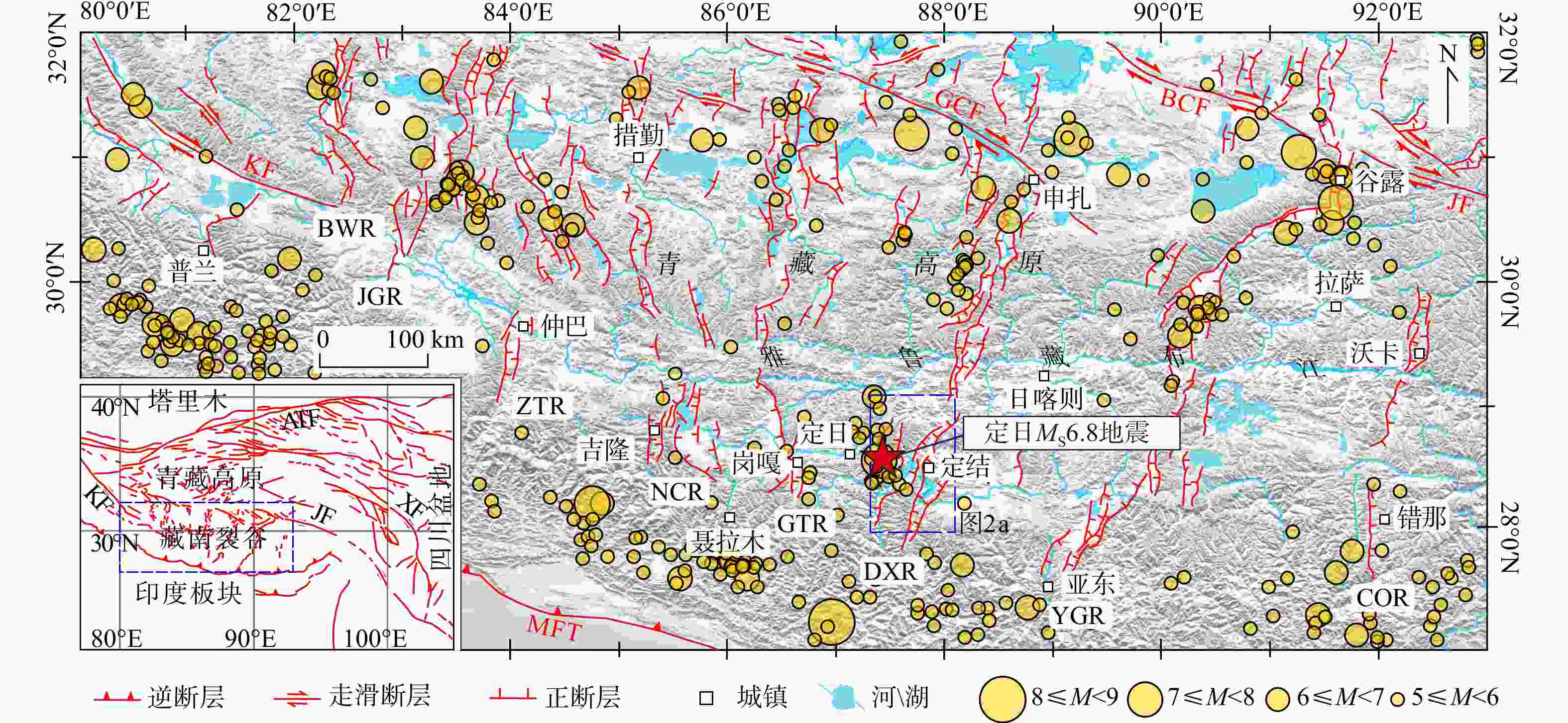
图 1 藏南裂谷构造简图(据高扬等,2025修改)
COR—错那−沃卡裂谷;YGR—亚东−谷露裂谷;DXR—定结−申扎裂谷;GTR—岗嘎−当惹雍错裂谷;NCR—聂拉木−措勤裂谷;ZTR—仲巴−塔若错裂谷;JGR—曲江藏布−改则裂谷;BWR—普兰−文布当桑裂谷;BCF—崩错断裂;GCF—格仁错断裂;KF—喀喇昆仑断裂;XF—鲜水河断裂;JF—嘉黎断裂;ATF—阿尔金断裂;MFT—主前锋逆冲断裂
Figure 1. Simplified tectonic diagram of the southern Tibet Rift Valley (modified after Gao et al., 2025)
COR—Cona–Oiga Rift; YGR—Yadong–Gulu Rift; DXR—Dinggye–Xainza Rift; GTR—Gangga–Tangra Yumco Rift; NCR—Nyalam–Coqen Rift; ZTR—Zhongba–Taro Co Rift; JGR—Jiangqu Zangbo–Gerze Rift; BWR—Burang–Wenbudangsang Rift; BCF—Beng Co Fault; GCF—Gyaring Co Fault; KF—Karakorum Fault; XF—Xianshuihe Fault; JF—Jiali Fault; ATF—Altyn Tagh Fault; MFT—Main Frontal Thrust
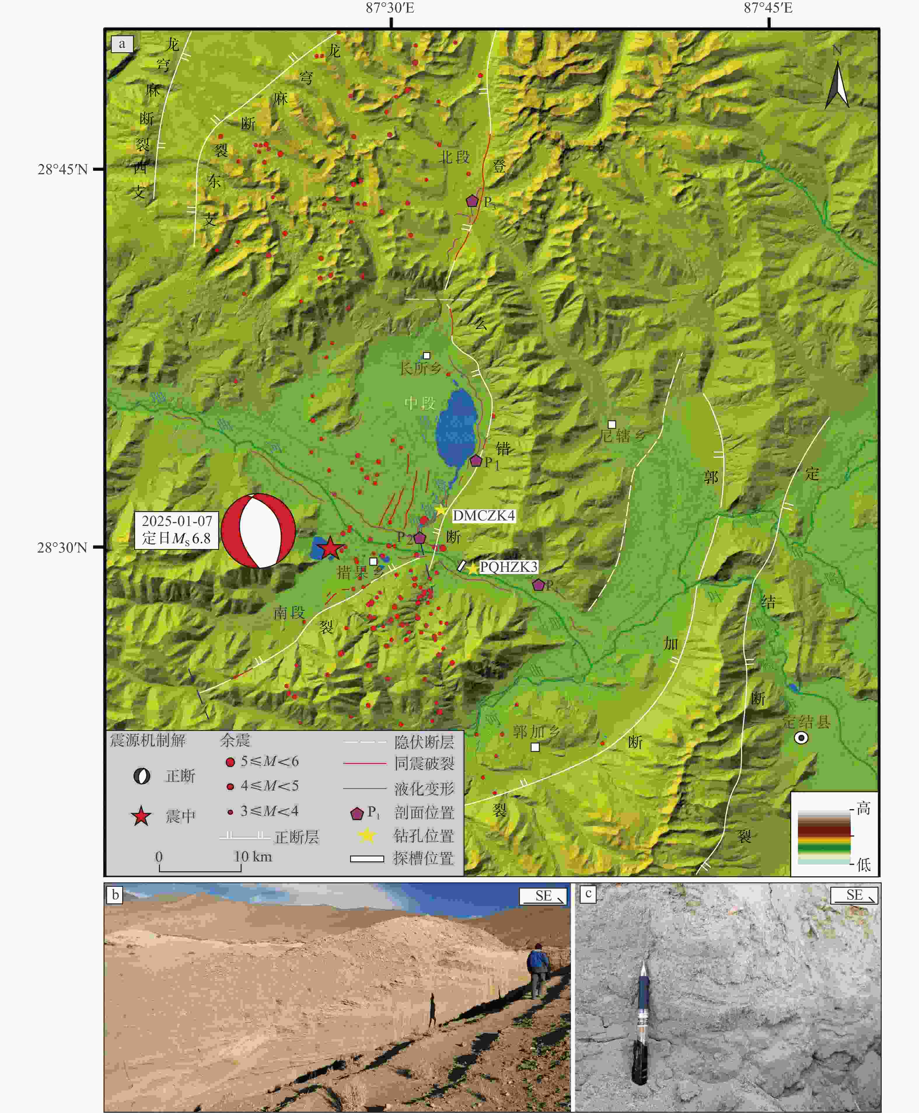
图 2 定日地震区域地震构造背景图及砂层沉积特征
a—定日地震区域地震构造背景;b—登么错湖东岸砂层沉积特征;c—砂层粒度特征
Figure 2. Regional seismic tectonic background and sedimentary characteristics of sand layers of the Dingri earthquake
(a) Seismotectonic background of the Dingri earthquake region; (b) Sedimentary characteristics of the sand layer on the east shore of Dengmecuo Lake; (c) Sand particle size characteristics
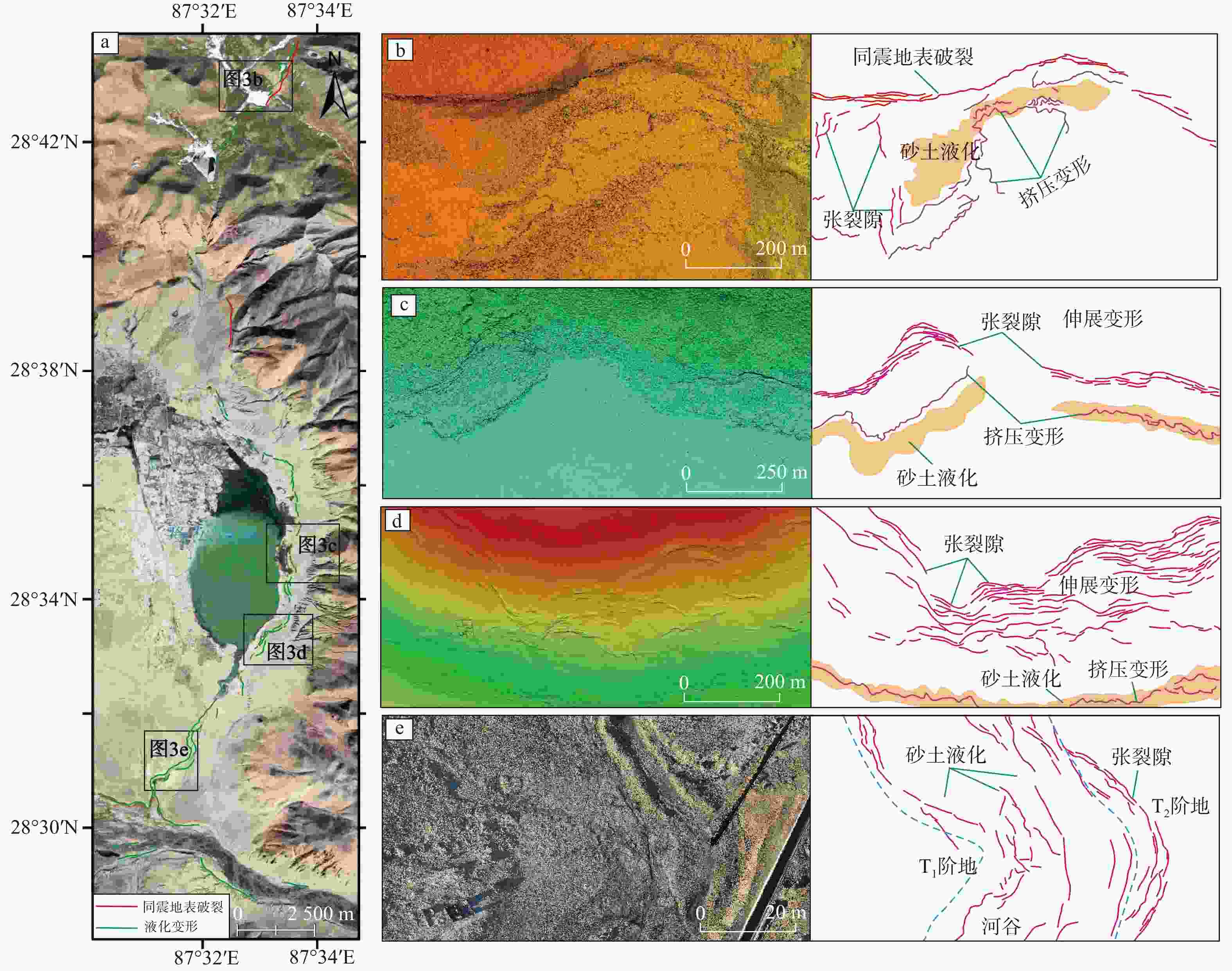
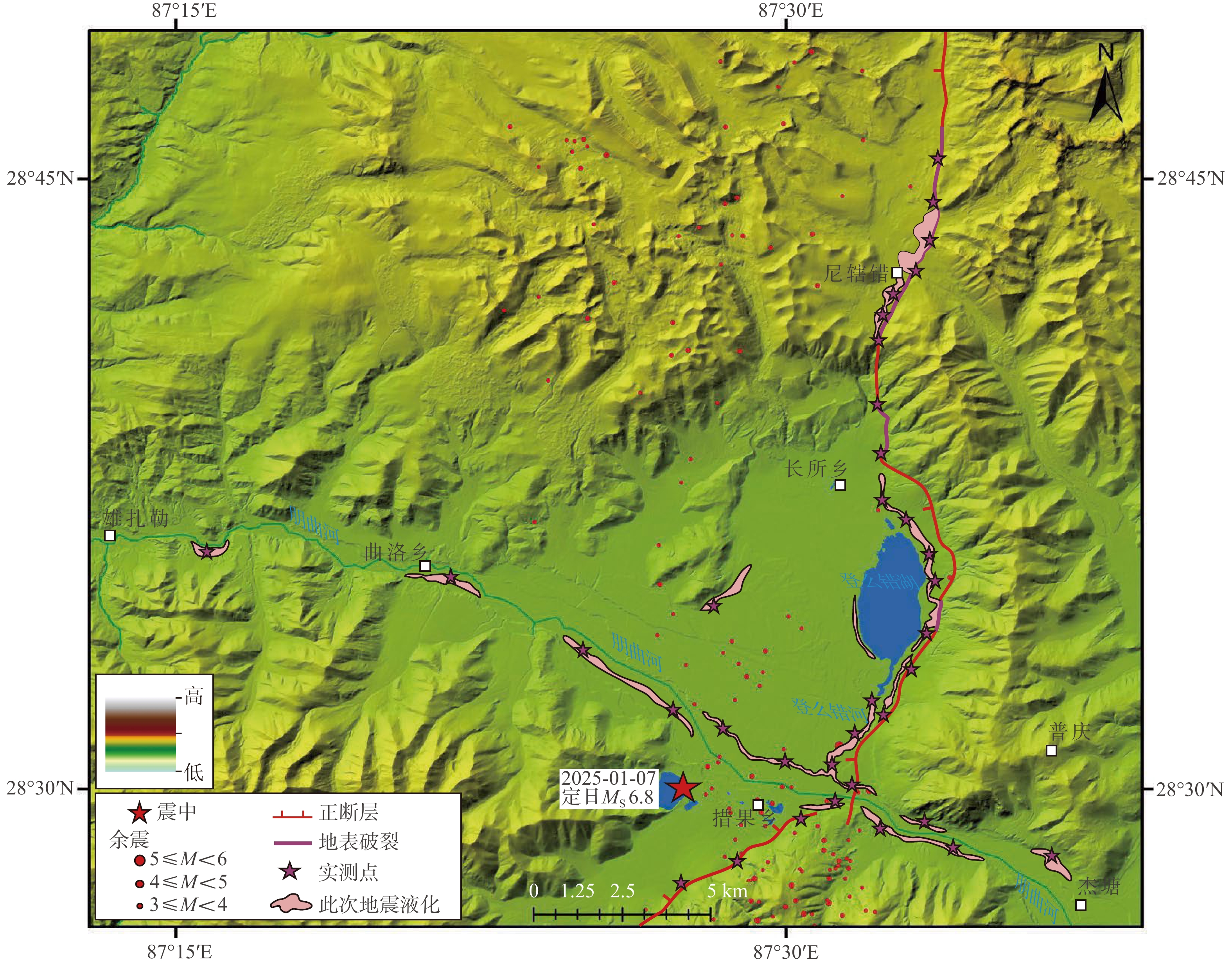
图 3 定日地震震区液化变形空间分布
DEM渐变色系代表高程变化,绿色系对应低地势区域,红棕色系代表高地势区域a—定日地震震区液化变形空间分布特征;b—登么错断裂北段同震地表破裂及液化变形无人机低空摄影DEM及素描;c—登么错湖东岸液化变形无人机低空摄影DEM及素描;d—登么错湖东岸南段液化变形无人机低空摄影DEM及素描;e—登么错河谷液化变形无人机低空摄影影像及素描
Figure 3. Spatial distribution of liquefaction deformation induced by the Dingri earthquake
(a) Spatial distribution characteristics of liquefaction deformation in the Dingri earthquake area; (b) UAV-based DEM and sketch of coseismic surface rupture and liquefaction deformation in the northern segment of the Dengmecuo Fault; (c) UAV-based DEM and sketch of liquefaction deformation on the eastern shore of Dengmecuo Lake; (d) UAV-based DEM and sketch of liquefaction deformation in the southern segment of the eastern shore of Dengmecuo Lake; (e) UAV photographs of liquefaction deformation in the Dengmecuo Valley and its sketchThe DEM color gradient represents elevation variation: green for low-relief zones, reddish-brown for high-relief terrain.
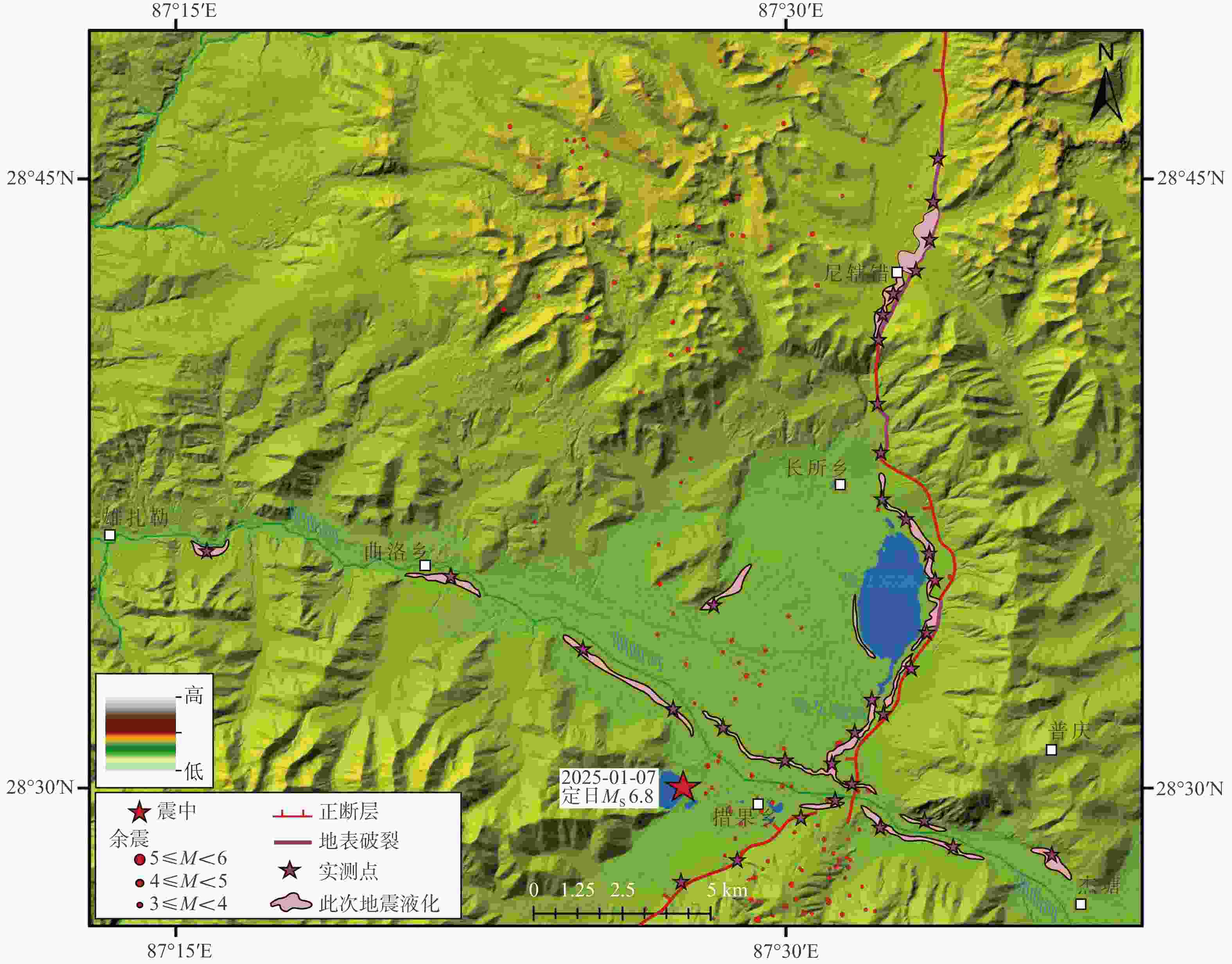
图 4 定日地震震区液化变形构造空间分布
Figure 4. Spatial distribution of liquefaction deformation induced by Dingri earthquake
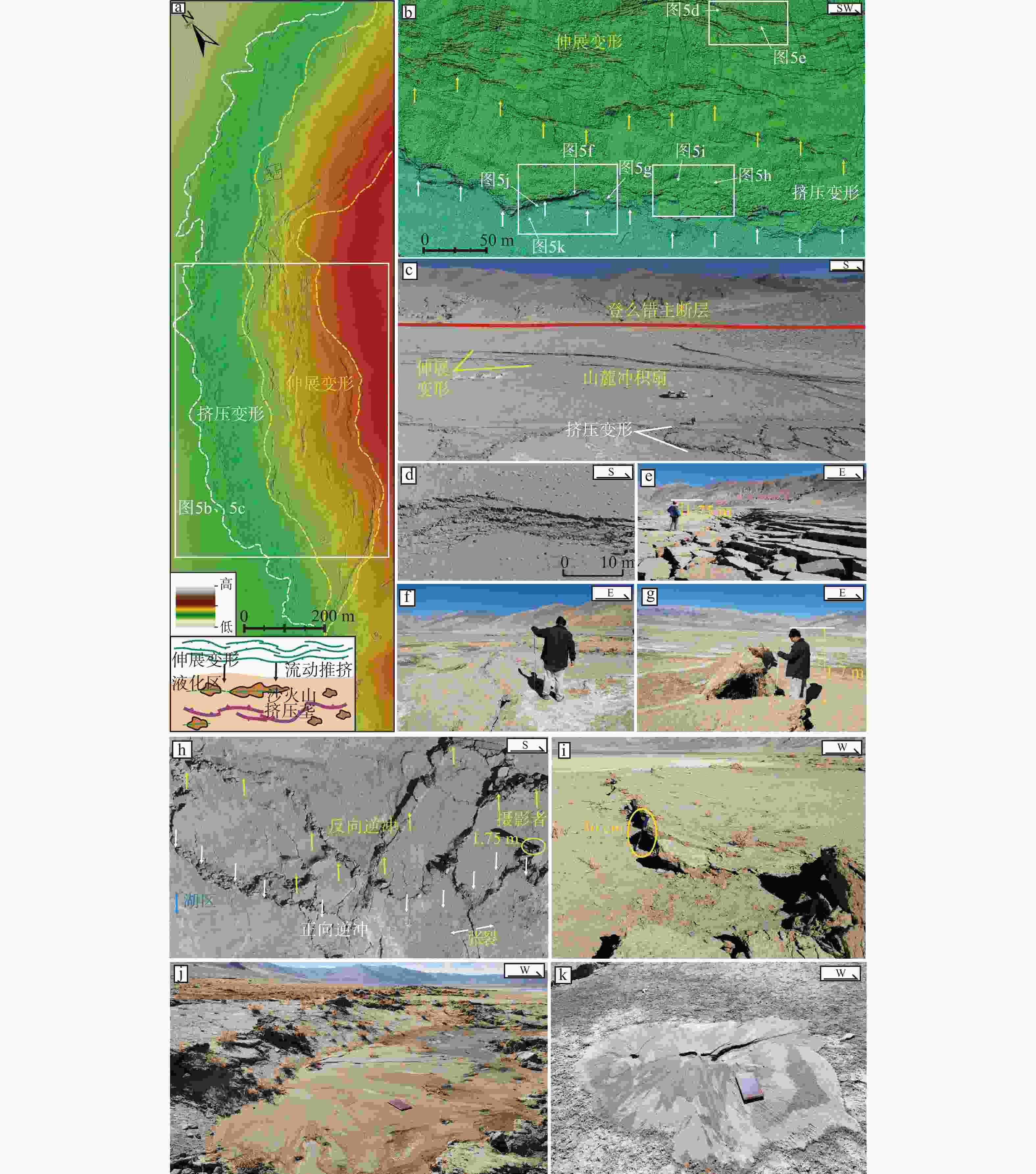
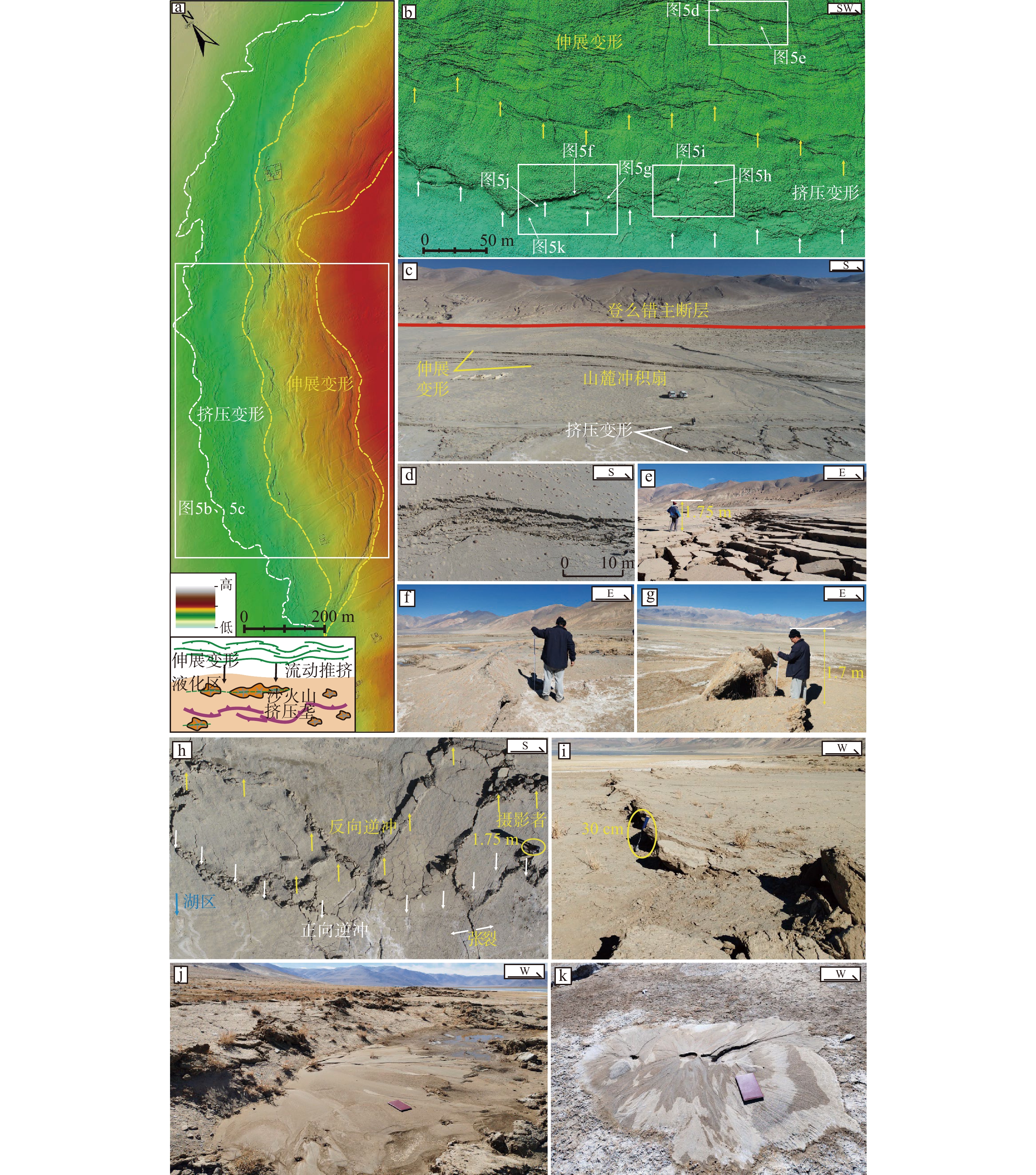
图 5 登么错湖东岸地震液化变形特征
a—登么错湖东岸液化变形区无人机低空摄影DEM(液化变形空间展布与高程变化一致);b—液化变形区伸展变形−挤压变形共存特征;c—液化变形区所在地形地貌特征;d—伸展变形宏观特征;e—伸展变形局部特征;f—挤压垄;g—薄皮对折构造;h—逆冲构造宏观特征;i—逆冲构造局部特征;j—挤压缩短区外缘的砂土液化特征;k—单个沙火山特征
Figure 5. Characteristics of earthquake-induced liquefaction deformation on the east shore of Dengmecuo Lake
(a) UAV low-altitude photogrammetric DEM of the liquefaction deformation zone on the eastern shore of Dengmecuo Lake (the DEM color scheme represents elevation variation, and the spatial distribution of liquefaction deformation is consistent with this variation); (b) Coexistence of extensional and compressional deformation features in the liquefaction deformation zone; (c) Topographic and geomorphic characteristics of the liquefaction deformation zone; (d) Macroscopic features of extensional deformation; (e) Local features of extensional deformation; (f) Compressional ridge; (g) Thin-skinned fold structure; (h) Macroscopic features of thrust structures; (i) Local features of thrust structures; (j) Sand liquefaction features at the outer margin of the compressional shortening zone; (k) Characteristics of an individual sand volcano
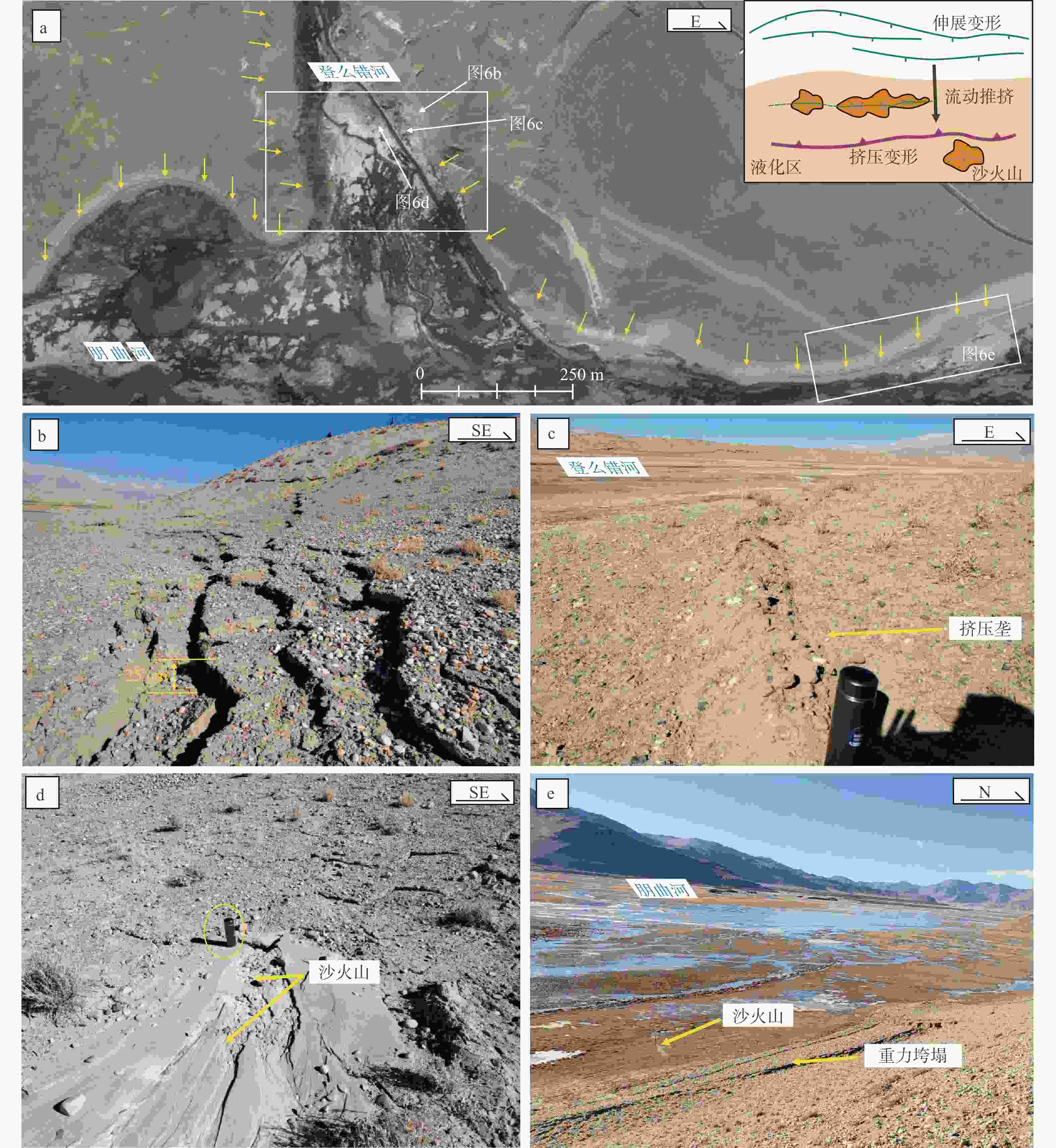
图 6 登么错河与朋曲河交汇处地震液化变形特征
a—登么错河与朋曲河交汇处震后遥感影像(黄色箭头指示了河谷边坡地带的伸展变形);b—登么错河沿岸伸展变形;c—登么错河河床上的挤压垄;d—登么错河谷沿线的砂土液化;e—朋曲河沿线的伸展变形与砂土液化现象(近EW向展布)
Figure 6. Characteristics of earthquake-induced liquefaction deformation at the confluence of Dengmecuo River and Pengqu River
(a) Post-earthquake remote sensing image of the confluence of the Dengmecuo River and Pengqu River (yellow arrows indicate extensional deformation along the valley slope zones); (b) Extensional deformation along the banks of the Dengmecuo River; (c) Compressional ridges on the riverbed of the Dengmecuo River; (d) Sand liquefaction along the Dengmecuo River valley; (e) Extensional deformation and sand liquefaction phenomena along the Pengqu River (distributed in a nearly EW orientation)
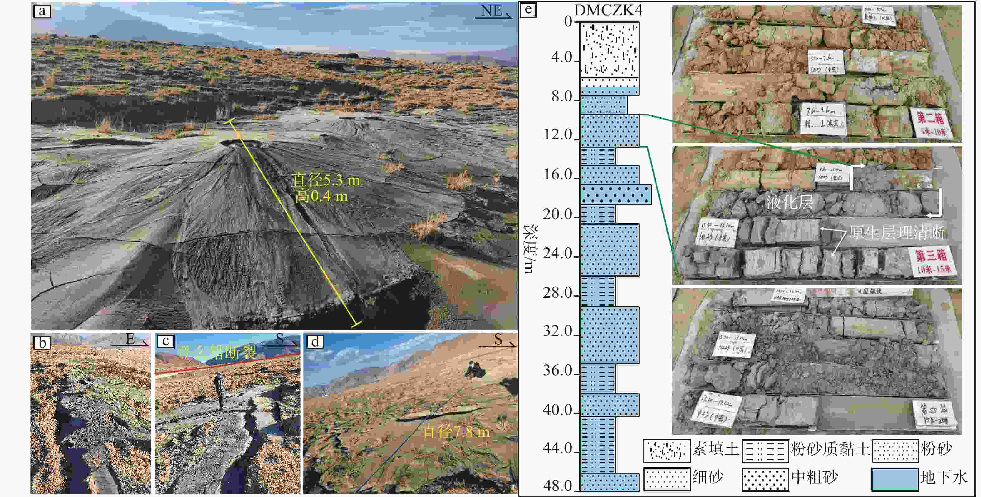
图 7 登么错河谷地震砂土液化特征
a—登么错河谷点状喷出的沙火山;b—线性展布的沙火山;c—沿伸展变形带线性喷出的沙火山;d—局部线性喷出的沙火山;e—登么错河谷液化变形区DMCZK4钻孔揭示的地层结构及岩芯照片
Figure 7. Characteristics of earthquake-induced sand liquefaction in the Dengmecuo River Valley
(a) Pointedly distributed sand volcanoes in the Dengmecuo River valley; (b) Linearly distributed sand volcanoes; (c) Sand volcanoes linearly erupted along the extensional deformation zone; (d) Locally linearly erupted sand volcanoes; (e) Stratigraphic sequence and core photographs revealed by the DMCZK4 borehole in the liquefaction deformation zone of the Dengmecuo River valley
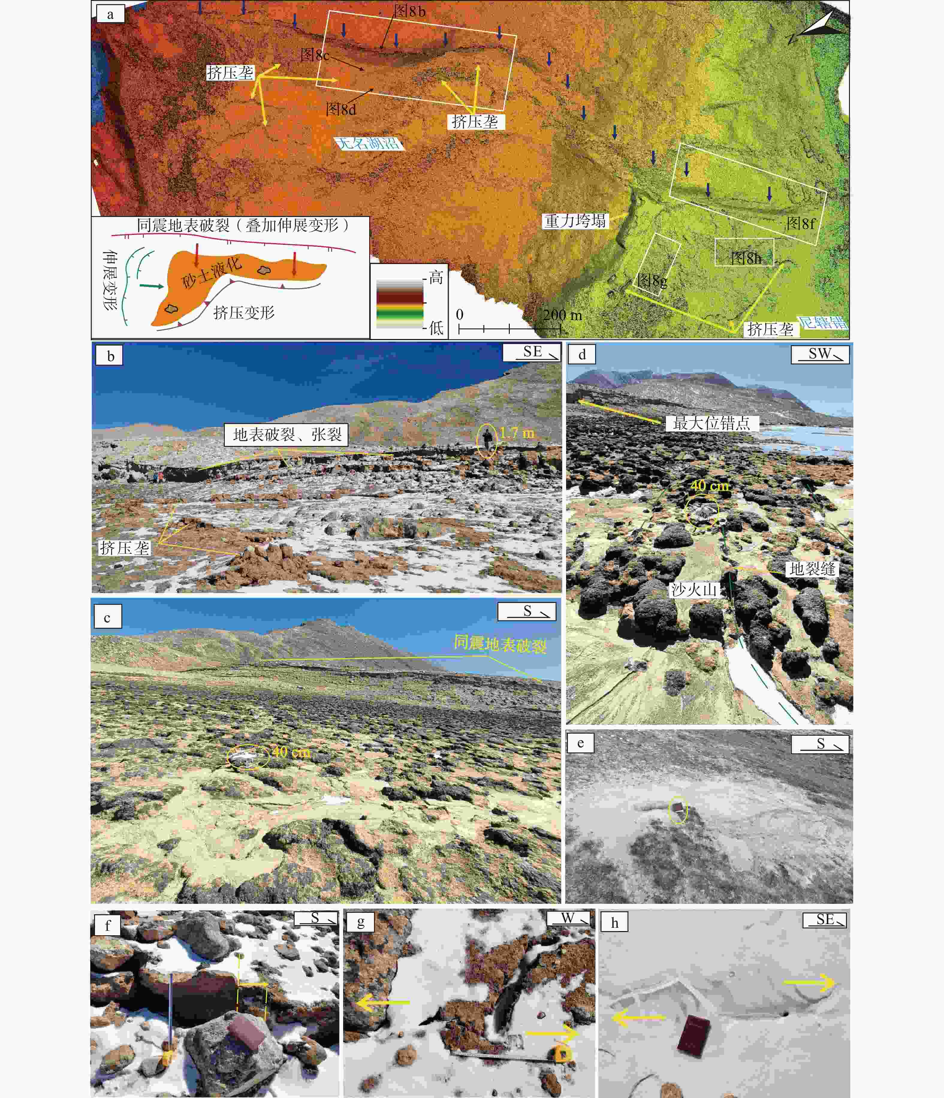
图 8 尼辖错−空摸错一带的地震液化变形特征
a—尼辖错北地表破裂无人机低空摄影DEM;b—同震地表破裂带附近的液化变形特征;c—断层上盘成片展布的沙火山;d—线性展布的沙火山;e—单个发育的沙火山;f—地表破裂带上的左旋走滑运动特征;g—断层上盘滑塌体右前方的左旋走滑特征;h—滑塌体左前方的右旋走滑特征
Figure 8. Characteristics of earthquake-induced liquefaction deformation in the Nixiacuo-Kongmecuo area
(a) UAV-based Low-altitude photogrammetric DEM of surface ruptures north of Nixiacuo; (b) Liquefaction and deformation features near the coseismic surface rupture zone; (c) Sand volcanoes distributed in patches on the hanging wall of the fault; (d) Linearly distributed sand volcanoes; (e) An individually developed sand volcano; (f) Left-lateral strike-slip movement characteristics along the surface rupture zone; (g) Left-lateral strike-slip features at the right front of the landslide mass on the hanging wall of the fault; (h) Right-lateral strike-slip features at the left front of the landslide mass
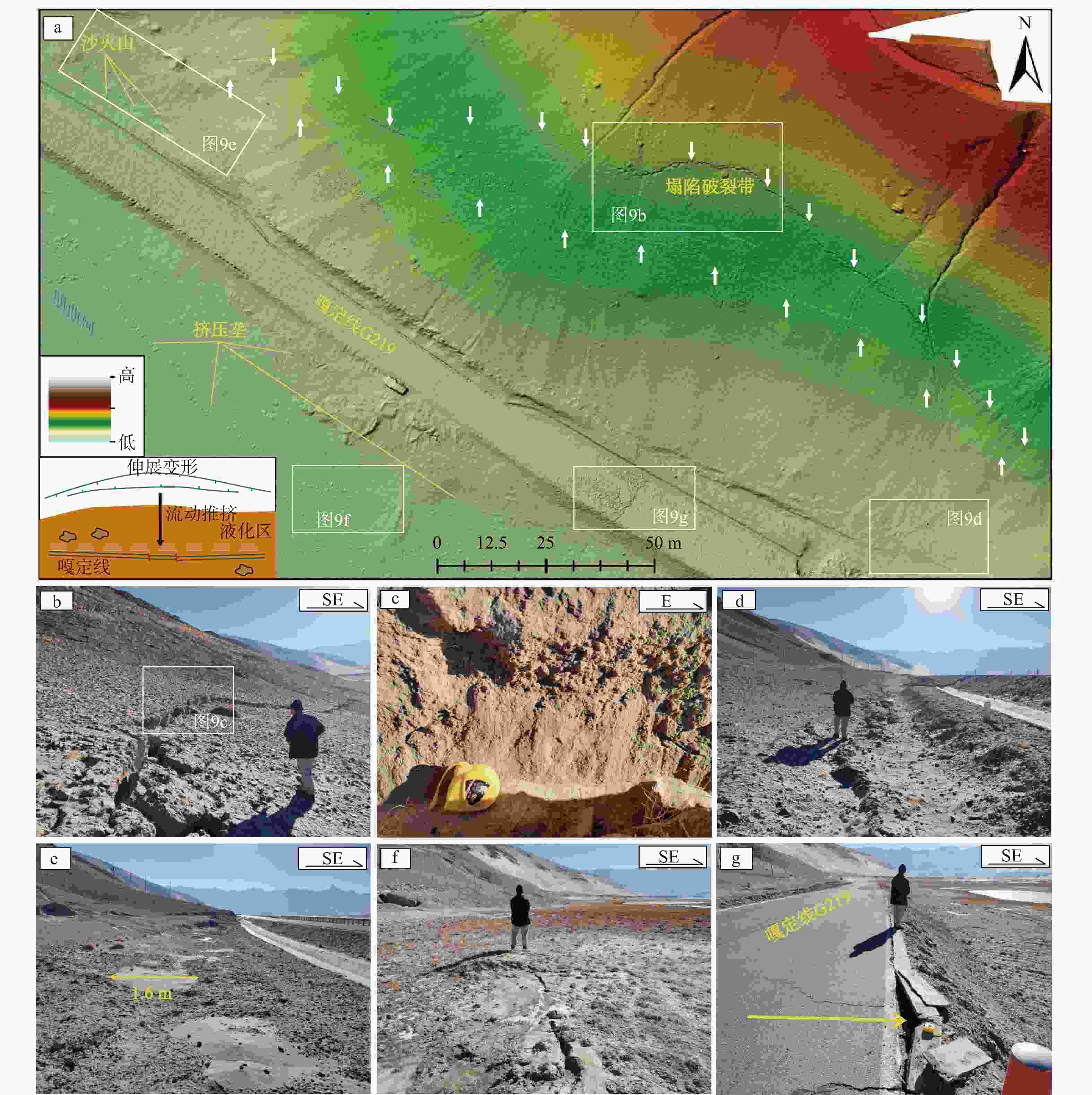
图 9 朋曲河北岸地震液化变形特征
a—朋曲河北岸液化变形无人机低空摄影DEM;b—伸展变形宏观特征;c—伸展变形带后缘的垂向滑动面;d—挤压垄;e—点状喷出的沙火山;f—沿地裂缝呈线性喷出的沙火山;g—公路地面遭受推挤变形
Figure 9. Characteristics of earthquake-induced liquefaction deformation on the north shore of the Pengqu River
(a) UAV-based low-altitude photogrammetric DEM of liquefaction and deformation on the north shore of the Pengqu River; (b) Macroscopic characteristics of extensional deformation; (c) Vertical slip surface at the rear margin of the extensional deformation zone; (d) Compressional ridge; (e) Point-source erupted sand volcanoes; (f) Linearly erupted sand volcanoes along ground fissures; (g) Compression deformation of the road surface
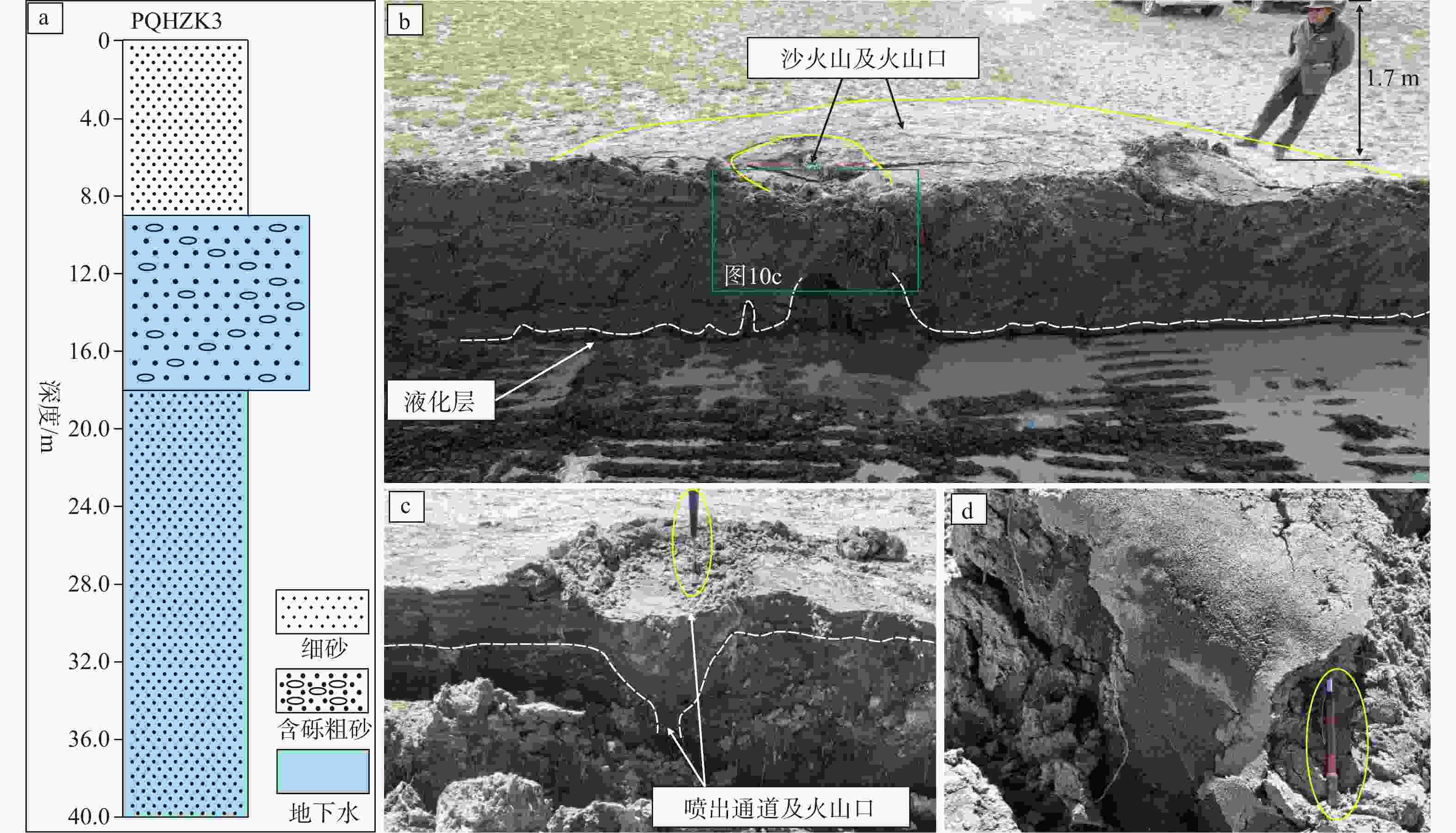
图 10 钻孔及探槽揭示的朋曲河北岸地层结构及砂土液化特征
a—钻孔揭示的朋曲河北岸未发生液化变形地区的地层结构与岩性特征;b—探槽揭示的朋曲河北岸T1阶地液化变形区的地层特征及沙火山与液化层的关系;c—探槽揭示的沙火山结构特征;d—液化层的岩性及粒度特征
Figure 10. Stratigraphic structure and sand liquefaction characteristics of the north shore of the Pengqu River revealed by drilling and trenching
(a) Stratigraphic structure and lithological characteristics of the non-liquefaction deformation area on the north shore of the Pengqu River revealed by boreholes; (b) Stratigraphic characteristics of the liquefaction deformation zone on the T1 terrace of the north shore of the Pengqu River and the relationship between sand volcanoes and liquefied layers revealed by trenches; (c) Structural characteristics of sand volcanoes revealed by trenches; (d) Lithological and grain size characteristics of the liquefied layer
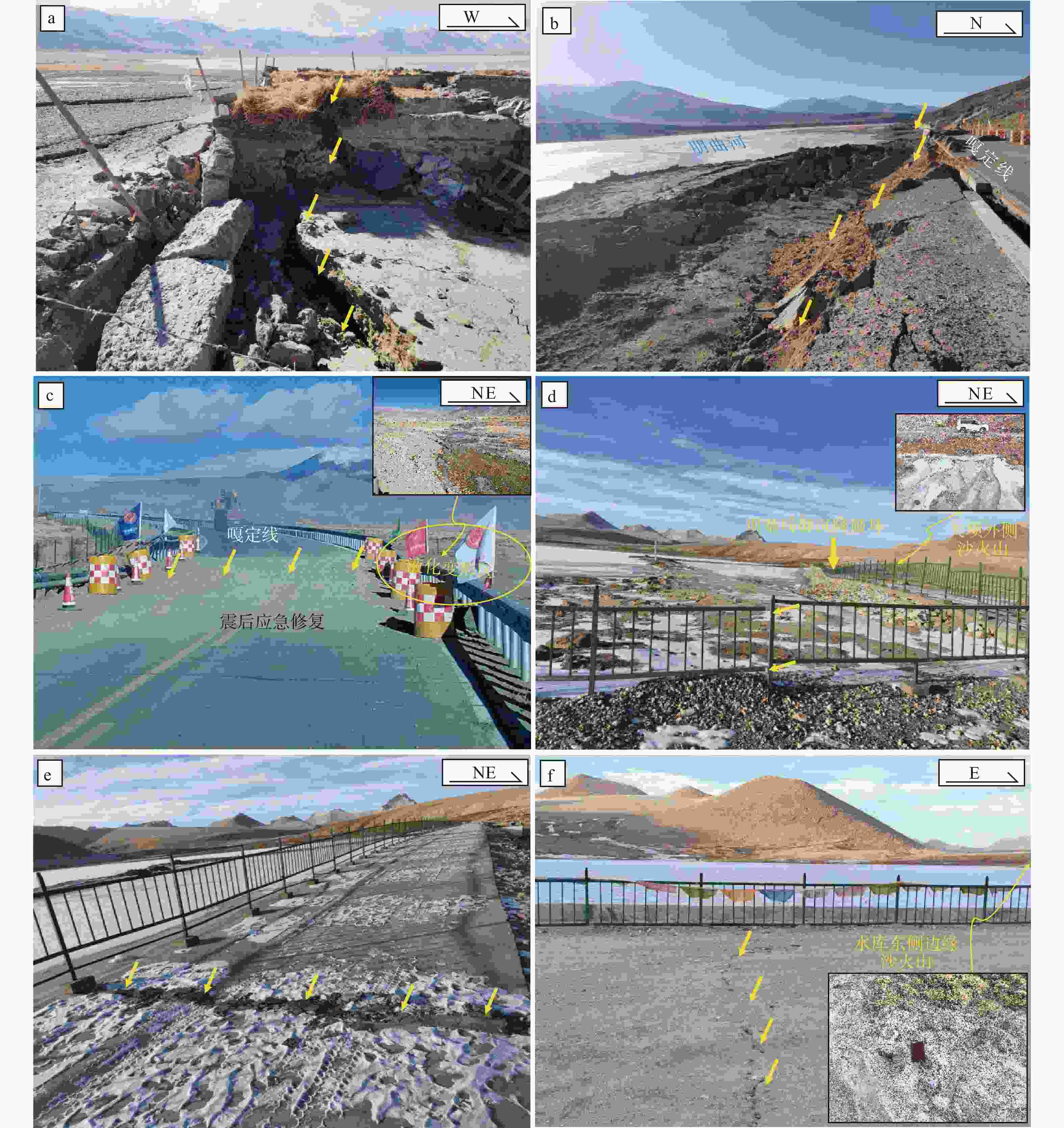
图 11 地震液化诱发次生灾害特征
a—登么错湖东岸地表塌陷破坏建筑物;b—液化变形造成朋曲河北岸嘎定线路基大面积破坏;c—液化变形破坏跨登么错河谷的交通主干道;d—尼辖错水库坝基差异性沉降;e—尼辖错水库坝基破裂;f—长所拉昂水库坝基破裂
Figure 11. Characteristics of secondary disasters induced by earthquake liquefaction
(a) Surface subsidence damaging buildings on the eastern shore of Dengmecuo Lake; (b) Large-scale damage to the Gading route subgrade on the north bank of the Pengqu River caused by liquefaction deformation; (c) Liquefaction deformation damaging the main traffic artery across the Dengmecuo River Valley; (d) Differential settlement of the dam foundation of Nixiacuo reservoir; (e) Dam foundation rupture of Nixiacuo reservoir; (f) Dam foundation rupture of Changsuo La’ang reservoir
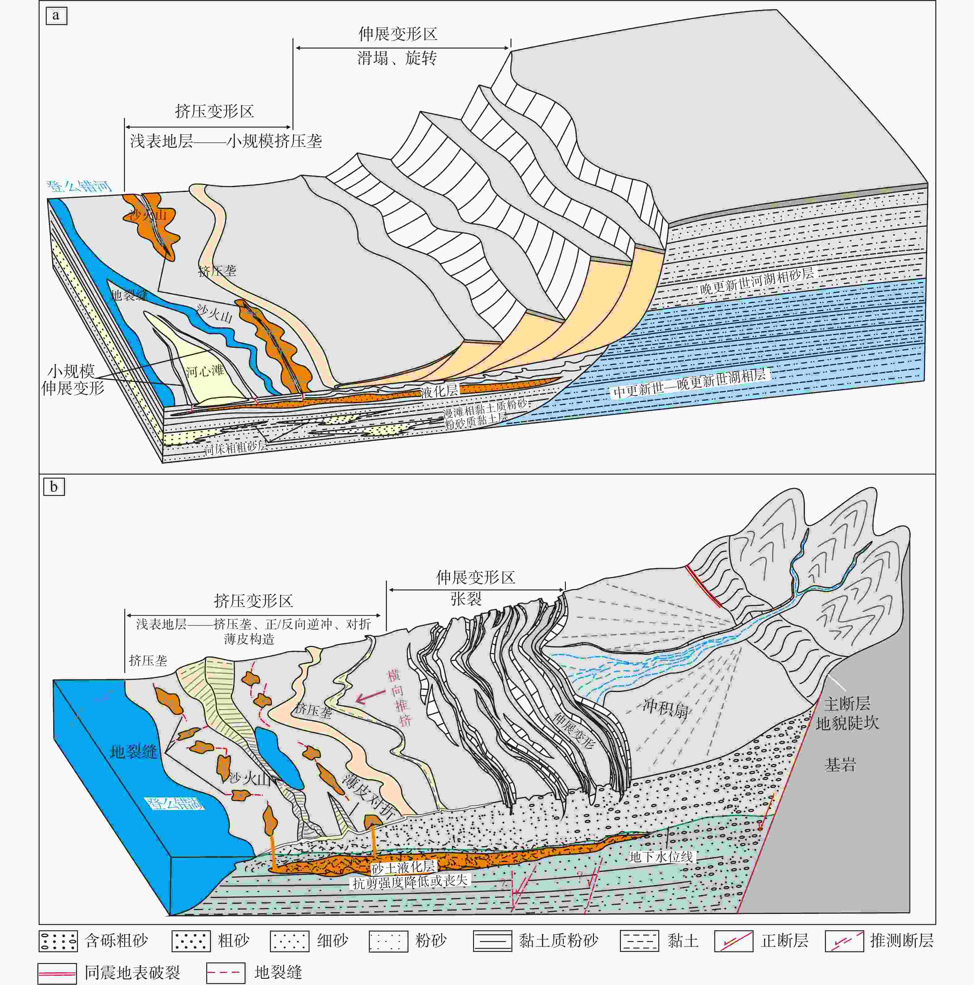
图 12 定日地震诱发液化大变形模式
a—登么错河—朋曲河沿线临空场液化大变形模式;b—登么错湖东岸缓倾斜场液化大变形模式
Figure 12. Patterns of deformation induced by liquefaction of the Dingri earthquake
(a) Liquefaction-induced large deformation model under free-face conditions along Dengmecuo River and Pengqu River; (b) Liquefaction-induced large deformation model under gently sloping ground conditions along the eastern shore of Dengmecuo Lake
表 1 定结−申扎裂谷南部主要活动断层信息
Table 1. Information on major active faults in the southern part of the Dinggye–Xainza Rift Valley
 下载: 导出CSV
-
[1] ALLEN J R L, 1977. The possible mechanics of convolute lamination in graded sand beds[J]. Journal of the Geological Society, 134(1): 19-31. doi: 10.1144/gsjgs.134.1.0019 [2] ARMIJO R, TAPPONNIER P, MERCIER J L, et al., 1986. Quaternary extension in southern Tibet: field observations and tectonic implications[J]. Journal of Geophysical Research: Solid Earth, 91(B14): 13803-13872. doi: 10.1029/JB091iB14p13803 [3] ARMIJO R, TAPPONNIER P, HAN T L, 1989. Late Cenozoic right-lateral strike-slip faulting in southern Tibet[J]. Journal of Geophysical Research: Solid Earth, 94(B3): 2787-2838. doi: 10.1029/JB094iB03p02787 [4] BARDET J P, TOBITA T, MACE N, et al., 2002. Regional modeling of liquefaction-induced ground deformation[J]. Earthquake Spectra, 18(1): 19-46. doi: 10.1193/1.1463409 [5] BARTLETT S F, YOUD T L, 1995. Empirical prediction of liquefaction-induced lateral spread[J]. Journal of Geotechnical Engineering, 121(4): 316-329. doi: 10.1061/(ASCE)0733-9410(1995)121:4(316) [6] BASTIN S H, QUIGLEY M C, BASSETT K, 2015. Paleoliquefaction in Christchurch, New Zealand[J]. GSA Bulletin, 127(9-10): 1348-1365. doi: 10.1130/B31174.1 [7] BIRD J F, BOMMER J J, 2004. Earthquake losses due to ground failure[J]. Engineering Geology, 75(2): 147-179. doi: 10.1016/j.enggeo.2004.05.006 [8] BRAY J D, TRAVASAROU T, 2007. Simplified procedure for estimating earthquake-induced deviatoric slope displacements[J]. Journal of Geotechnical and Geoenvironmental Engineering, 133(4): 381-392. doi: 10.1061/(ASCE)1090-0241(2007)133:4(381) [9] CAI X G, YUAN X M, LIU H L, et al., 2005. Mechanism and softening modulus approach for liquefaction-induced lateral spreading of ground near river bank or seashore[J]. Earthquake Engineering and Engineering Vibration, 25(3): 125-131. (in Chinese with English abstract) [10] CHEN L W, LIU H R, REN Y F, et al., 2024. In-situ investigation of site liquefaction and liquefaction-induced damages triggered by two strong Türkiye earthquakes on Feb. 6th, 2023[J]. Chinese Journal of Geotechnical Engineering, 46(7): 1541-1548. (in Chinese with English abstract) [11] CHEN Z X, CHEN Y H, ZHANG Y M, et al., 2023. Assessment of liquefaction-induced lateral spread using soft computing approaches[J]. Gondwana Research, 123: 265-279. doi: 10.1016/j.gr.2022.08.006 [12] CHEVALIER M L, TAPPONNIER P, VAN DER WOERD J, et al., 2020. Late quaternary extension rates across the northern half of the Yadong-Gulu rift: implication for east-west extension in southern Tibet[J]. Journal of Geophysical Research: Solid Earth, 125(7): e2019JB019106. doi: 10.1029/2019JB019106 [13] CILIA M G, MOONEY W D, NUGROHO C, 2021. Field insights and analysis of the 2018 Mw 7.5 Palu, Indonesia earthquake, tsunami and landslides[J]. Pure and Applied Geophysics, 178(12): 4891-4920. doi: 10.1007/s00024-021-02852-6 [14] ESPER P, TACHIBANA E, 1998. Lessons from the Kobe earthquake[J]. Geological Society, London, Engineering Geology Special Publications, 15: 105-116. [15] FANG H Q, ZHAO S D, HUANG Z L, 1983. Controlling influence of geomorphological features on seismic liquefaction[J]. Geotechnical Investigation & Surveying(2): 11-15. (in Chinese with English abstract) [16] GAO G Y, HONG Y, GENG J L, et al., 2022. Numerical simulation of saturated sand liquefaction discrimination and amplification effect[J]. Journal of Engineering Geology, 30(6): 1874-1881. (in Chinese with English abstract) [17] GAO Y, 2024. Spatial-temporal characteristics of the Quaternary NS-trending normal faulting in the Dinggye-Gyrong area, southern Tibet[D]. Beijing: Peking University. (in Chinese with English abstract) [18] GAO Y, WU Z H, ZUO J M, et al., 2024. Spatial-temporal activity of Quaternary faults at southern end of Nyalam-Coqen rift, southern Tibet[J]. Earth Science, 49(7): 2552-2569. (in Chinese with English abstract) [19] GAO Y, WU Z H, HAN S, et al., 2025. Late quaternary throw rate of the seismogenic fault (Dengmecuo Fault) of the 2025 MS6.8 Dingri earthquake in Shigatse[J]. Seismology and Geology, 47(3): 689-706. (in Chinese with English abstract) [20] GONG J, ZOU D G, KONG X J, et al., 2024. Liquefaction-induced large deformation method with automatic time-step mapping and interfacial interpolation improvement: case study of the San Fernando Dam[J]. Computers and Geotechnics, 171: 106351. doi: 10.1016/j.compgeo.2024.106351 [21] GREEN R A, CUBRINOVSKI M, COX B, et al., 2014. Select liquefaction case histories from the 2010-2011 Canterbury earthquake sequence[J]. Earthquake Spectra, 30(1): 131-153. doi: 10.1193/030713EQS066M [22] HA G H, 2019. Normal faulting of central-southern Yadong-Gulu rift Since late Cenozoic, southern Tibet[D]. Beijing: Chinese Academy of Geological Sciences. (in Chinese with English abstract) [23] HOANG T N, NGUYEN T T, NGUYEN T V, et al., 2024. SPH simulation of earthquake-induced liquefaction and large deformation behaviour of granular materials using SANISAND constitutive model[J]. Computers and Geotechnics, 174: 106617. doi: 10.1016/j.compgeo.2024.106617 [24] HOU L Y, SHAN X J, GONG W Y, et al., 2020. Characterizing seismogenic fault of 2016 Dingjie earthquake based on multitemporal DInSAR[J]. Chinese Journal of Geophysics, 63(4): 1357-1369. (in Chinese with English abstract) [25] HUANG T, WU Z H, HAN S, et al., 2024. The basic characteristics of active faults in the region of Xigaze, Xizang and the assessment of potential earthquake disaster risks[J]. Progress in Earthquake Sciences, 54(10): 696-711. (in Chinese with English abstract) [26] IWATATE T, KOBAYASHI Y, KUSU H, et al. , 1999. Investigation and shaking table tests of subway structures of the Hyogoken-Nanbu earthquake[C]//Proceedings of the 4th international conference on recent advances in geotechnical earthquake engineering and soil dynamics. [27] JALIL A, FATHANI T F, SATYARNO I, et al., 2021. Liquefaction in Palu: the cause of massive mudflows[J]. Geoenvironmental Disasters, 8(1): 21. doi: 10.1186/s40677-021-00194-y [28] LIANG M J, DONG Y X, ZUO H, et al., 2025. Surface deformation characteristics and causes of the Dengmecuo segment in the Xizang Dingri Ms6.8 earthquake[J]. Seismology and Geology, 47(1): 80-89. (in Chinese with English abstract) [29] LIU F C, PAN J W, LI H B, et al., 2025. Co-seismic surface rupture of the 2025 Mw7.1 Tingri earthquake and potential seismic risk in southern Tibetan Plateau[J]. Acta Geologica Sinica, 99(3): 685-703. (in Chinese with English abstract) [30] LIU H S, XU F P, LI P C, 1997. The influence of large ground displacement caused by liquefaction on engineering and its research status[J]. Earthquake Resistant Engineering(2): 21-26. (in Chinese with English abstract) [31] LIU S, TANG X W, LUAN Y X, et al., 2021. Seismic response analysis of subway station in deep loose sand using the ALE method[J]. Computers and Geotechnics, 139: 104394. doi: 10.1016/j.compgeo.2021.104394 [32] LIU X L, XIA T, LIU-ZENG J, et al., 2022. Distributed characteristics of the surface deformations associated with the 2021 Mw7.4 Madoi earthquake, Qinghai, China[J]. Seismology and Geology, 44(2): 461-483. (in Chinese with English abstract) [33] MAGHSOUDI M S, JAMSHIDI CHENARI R, FARROKHI F, 2022. Liquefaction induced permanent ground deformations and energy dissipation analysis based on smoothed particle hydrodynamics method (SPH): validation by large-scale model tests[J]. Granular Matter, 24(4): 104. doi: 10.1007/s10035-022-01267-x [34] MCCALPIN J P, 2009. Paleoseismology[M]. 2nd ed. Burlington: Academic Press. [35] Ministry of Emergency Management of the People's Republic of China, 2025. Office of the national committee for disaster prevention, mitigation and relief, ministry of emergency management releases national natural disaster situation in January 2025[EB/OL]. (2025-03-06)[2025-05-13]. https://www.119.gov.cn/qmxfxw/xfyw/2025/48608.shtml. (in Chinese) [36] MOLNAR P, TAPPONNIER P, 1975. Cenozoic tectonics of Asia: effects of a continental collision: features of recent continental tectonics in Asia can be interpreted as results of the India-Eurasia collision[J]. Science, 189(4201): 419-426. doi: 10.1126/science.189.4201.419 [37] OBERMEIER S F, 1996. Use of liquefaction-induced features for paleoseismic analysis - An overview of how seismic liquefaction features can be distinguished from other features and how their regional distribution and properties of source sediment can be used to infer the location and strength of Holocene paleo-earthquakes[J]. Engineering Geology, 44(1-4): 1-76. doi: 10.1016/s0013-7952(96)00040-3 [38] OWEN G, MORETTI M, ALFARO P, 2011. Recognising triggers for soft-sediment deformation: current understanding and future directions[J]. Sedimentary Geology, 235(3-4): 133-140. doi: 10.1016/j.sedgeo.2010.12.010 [39] PARK R, BILLINGS I J, CLIFTON G C, et al., 1995. The Hyogo-ken Nanbu earthquake (the Great Hanshin earthquake) of 17 January 1995: report of the NZNSEE reconnaissance team[J]. Bulletin of the New Zealand Society for Earthquake Engineering, 28(1): 1-98. doi: 10.5459/bnzsee.28.1.1-98 [40] QUIGLEY M, VAN DISSEN R, LITCHFIELD N, et al., 2012. Surface rupture during the 2010 MW 7.1 Darfield (Canterbury) earthquake: implications for fault rupture dynamics and seismic-hazard analysis[J]. Geology, 40(1): 55-58. doi: 10.1130/G32528.1 [41] QUIGLEY M C, HUGHES M W, BRADLEY B A, et al. , 2016. The 2010-2011 Canterbury earthquake sequence: environmental effects, seismic triggering thresholds and geologic legacy[J]. Tectonophysics, 672-673: 228-274. [42] ROBINSON K, BRADLEY B A, CUBRINOVSKI M, 2012. Analysis of liquefaction-induced lateral spreading data from the 2010 Darfield and 2011 Christchurch earthquakes[C]//Proceedings of the NZSEE annual technical conference & AGM. Christchurch: University of Canterbury. [43] SCOTT B, PRICE S, 1988. Earthquake-induced structures in young sediments[J]. Tectonophysics, 147(1-2): 165-170. doi: 10.1016/0040-1951(88)90154-0 [44] SEED H B, 1979. Soil liquefaction and cyclic mobility evaluation for level ground during earthquakes[J]. Journal of the Geotechnical Engineering Division, 105(2): 201-255. doi: 10.1061/ajgeb6.0000768 [45] SEED H B, IDRISS I M, ARANGO I, 1983. Evaluation of liquefaction potential using field performance data[J]. Journal of Geotechnical Engineering, 109(3): 458-482. doi: 10.1061/(ASCE)0733-9410(1983)109:3(458) [46] SHAHBODAGH B, SADEGHI H, KIMOTO S, et al., 2020. Large deformation and failure analysis of river embankments subjected to seismic loading[J]. Acta Geotechnica, 15(6): 1381-1408 [47] SHAO Y X, WANG A S, LIU-ZENG J, et al., 2025. Preliminary investigation on surface rupture and coseismic displacement of the January 7, 2025 Dingri earthquake in Xizang[J]. Earth Science, 50(5): 1677-1695. (in Chinese with English abstract) [48] SHAO Z G, ZHU D G, MENG X G, et al., 2013. The definition and classification of Quaternary Lacustrine strata and the establishment of Dingjie Group in Dingjie basin, Tibet[J]. Geology in China, 40(2): 449-459. (in Chinese with English abstract) [49] SHI F, LIANG M J, LUO Q X, et al., 2025. Seismogenic fault and coseismic surface deformation of the Dingri Ms6.8 earthquake in Xizang, China[J]. Seismology and Geology, 47(1): 1-15. (in Chinese with English abstract) [50] TANJUNG M I, IRSYAM M, SAHADEWA A, et al., 2023. Overview of Flowslide in Petobo during liquefaction of the 2018 Palu earthquake[J]. Soil Dynamics and Earthquake Engineering, 173: 108110. doi: 10.1016/j.soildyn.2023.108110 [51] TIAN T T, 2021. Dating of late Quaternary paleoseismic events of the Dingmu Cuo fault in the southern section of Shenzha-Dingjie Rift[D]. Beijing: China University of Geosciences (Beijing). (in Chinese with English abstract) [52] TIAN T T, WU Z H, 2023. Recent prehistoric major earthquake event of Dingmucuo Normal fault in the southern segment of Shenzha-Dingjie Rift and its seismic geological significance[J]. Geological Review, 69(S1): 53-55. (in Chinese with English abstract) [53] TOKIMATSU K, SEED H B, 1987. Evaluation of settlements in sands due to earthquake shaking[J]. Journal of Geotechnical Engineering, 113(8): 861-878. doi: 10.1061/(ASCE)0733-9410(1987)113:8(861) [54] TOWHATA I, ORENSE R P, TOYOTA H, 1999. Mathematical principles in prediction of lateral ground displacement induced by seismic liquefaction[J]. Soils and Foundations, 39(2): 1-19. doi: 10.3208/sandf.39.2_1 [55] TOYOTA H, KAZAMA M, 2024. Liquefaction traces on the Shinano River left bank after the 1964 Niigata Earthquake - Liquefaction research issues suggested by geoslicer survey results-[J]. Japanese Geotechnical Society Special Publication, 10(10): 253-258. doi: 10.3208/jgssp.v10.SS-5-03 [56] VAID Y P, THOMAS J, 1995. Liquefaction and postliquefaction behavior of sand[J]. Journal of Geotechnical Engineering, 121(2): 163-173. doi: 10.1061/(ASCE)0733-9410(1995)121:2(163) [57] WANG Z Q, 1983. Introduction to earthquake engineering geology[M]. Beijing: Seismological Press. (in Chinese) [58] WU Z H, YE P S, WANG C M, et al., 2015. The relics, ages and significance of prehistoric large earthquakes in the Angang Graben in South Tibet[J]. Earth Science: Journal of China University of Geosciences, 40(10): 1621-1642. (in Chinese with English abstract) [59] YAN J Y, FENG J, ZHANG X H, et al., 2025. Preliminary investigation on surface deformation characteristics of the Ms 7.1 earthquake in Wushi County, Aksu Prefecture, Xinjiang, on January 23, 2024[J]. Acta Scientiarum Naturalium Universitatis Pekinensis, 61(2): 388-402. (in Chinese with English abstract) [60] YASUDA S, NAGASE H, KIKU H, et al., 1992. The mechanism and a simplified procedure for the analysis of permanent ground displacement due to liquefaction[J]. Soils and Foundations, 32(1): 149-160. doi: 10.3208/sandf1972.32.149 [61] YOUD T L, HANSEN C M, BARTLETT S F, 2002. Revised multilinear regression equations for prediction of lateral spread displacement[J]. Journal of Geotechnical and Geoenvironmental Engineering, 128(12): 1007-1017. doi: 10.1061/(ASCE)1090-0241(2002)128:12(1007) [62] YUAN H M, YANG S H, ANDRUS R D, et al., 2004. Liquefaction-induced ground failure: a study of the Chi-Chi earthquake cases[J]. Engineering Geology, 71(1-2): 141-155. doi: 10.1016/S0013-7952(03)00130-3 [63] YUAN X M, CAO Z Z, SUN R, et al., 2009. Preliminary research on liquefaction characteristics of Wenchuan 8.0 earthquake[J]. Chinese Journal of Rock Mechanics and Engineering, 28(6): 1288-1296. (in Chinese with English abstract) [64] YUAN Z D, LIU-ZENG J, LI X, et al., 2021. Detailed mapping of the surface rupture of the 12 February 2014 Yutian Ms7.3 earthquake, Altyn Tagh Fault, Xinjiang, China[J]. Science China Earth Sciences, 64(1): 127-147. doi: 10.1007/s11430-020-9673-6 [65] ZHANG J M, WANG R, 2024. Large post-liquefaction deformation of sand: mechanisms and modeling considering water absorption in shearing and seismic wave conditions[J]. Underground Space, 18: 3-64. doi: 10.1016/j.undsp.2024.03.001 [66] ZHUANG H Y, LI X X, ZHANG K, et al., 2025. Liquefaction-induced lateral spreading characteristics of the fluvial terraces at the lower reaches of Yangtze River[J]. Engineering Geology, 346: 107900. doi: 10.1016/j.enggeo.2024.107900 [67] ZOU J J, SHAO Z G, HE H L, et al., 2025. Surface rupture interpretation and building damage assessment of Xizang Dingri MS6.8 earthquake on January 7, 2025[J]. Seismology and Geology, 47(1): 16-35. (in Chinese with English abstract) [68] ZUO J M, 2021. Late Quaternary activity characteristics of the Chongba Yumtso normal fault in the southern section of the Yadong-Gullu Rift, Tibet[D]. Beijing: China University of Geosciences (Beijing). (in Chinese with English abstract) [69] 蔡晓光, 袁晓铭, 刘汉龙, 等, 2005. 近岸水平场地液化侧向大变形机理及软化模量分析方法[J]. 地震工程与工程振动, 25(3): 125-131. [70] 陈龙伟, 刘昊儒, 任叶飞, 等, 2024. 2023年2月6日土耳其双强震场地液化及其震害特征现场调查分析[J]. 岩土工程学报, 46(7): 1541-1548. doi: 10.11779/CJGE20230333 [71] 方鸿琪, 赵树栋, 黄振录, 1983. 地貌特征对地震液化的控制性影响[J]. 工程勘察(2): 11-15. [72] 高广运, 洪洋, 耿建龙, 等, 2022. 饱和砂土液化判别与放大效应数值模拟研究[J]. 工程地质学报, 30(6): 1874-1881. [73] 高扬, 2024. 藏南定结-吉隆地区第四纪近南北向正断层作用的时空特征[D]. 北京: 北京大学. [74] 高扬, 吴中海, 左嘉梦, 等, 2024. 藏南聂拉木-措勤裂谷南段第四纪正断层作用的时空特征[J]. 地球科学, 49(7): 2552-2569. [75] 高扬, 吴中海, 韩帅, 等, 2025. 2025年定日MS6.8地震发震断层(登么错断裂)晚第四纪垂直滑动速率[J]. 地震地质, 47(3): 689-706. [76] 哈广浩, 2019. 藏南亚东—谷露裂谷中—南段晚新生代正断层作用[D]. 北京: 中国地质科学院. [77] 侯丽燕, 单新建, 龚文瑜, 等, 2020. 基于多期DInSAR数据的2016年定结地震序列发震断层特征研究[J]. 地球物理学报, 63(4): 1357-1369. [78] 黄婷, 吴中海, 韩帅, 等, 2024. 西藏日喀则地区的活断层基本特征及地震灾害潜在风险评估[J]. 地震科学进展, 54(10): 696-711. doi: 10.19987/j.dzkxjz.2024-003 [79] 梁明剑, 董芸希, 左洪, 等, 2025. 2025年西藏定日6.8级地震登么错段地表变形特征及其成因[J]. 地震地质, 47(1): 80-89. [80] 刘富财, 潘家伟, 李海兵, 等, 2025. 2025年Mw7.1西藏定日地震地表破裂与同震位移分布特征[J]. 地质学报, 99(3): 685-703. doi: 10.19762/j.cnki.dizhixuebao.2025069 [81] 刘惠珊, 徐凤萍, 李鹏程, 1997. 液化引起的地面大位移对工程的影响及研究现状[J]. 工程抗震(2): 21-26. [82] 刘小利, 夏涛, 刘静, 等, 2022. 2021年青海玛多MW7.4地震分布式同震地表裂缝特征[J]. 地震地质, 44(2): 461-483. doi: 10.3969/j.issn.0253-4967.2022.02.012 [83] 邵延秀, 王爱生, 刘静, 等, 2025. 2025年1月7日西藏定日地震地表破裂特征和野外同震位移测量初步结果[J]. 地球科学, 50(5): 1677-1695. [84] 邵兆刚, 朱大岗, 孟宪刚, 等, 2013. 西藏定结盆地第四纪湖相地层的厘定、划分和定结群的建立[J]. 中国地质, 40(2): 449-459. doi: 10.3969/j.issn.1000-3657.2013.02.009 [85] 石峰, 梁明剑, 罗全星, 等, 2025. 2025年1月7日西藏定日6.8级地震发震构造与同震地表破裂特征[J]. 地震地质, 47(1): 1-15. [86] 田婷婷, 2021. 申扎-定结裂谷南段丁木错断裂晚第四纪古地震事件研究[D]. 北京: 中国地质大学(北京). [87] 田婷婷, 吴中海, 2023. 西藏申扎—定结裂谷南段丁木错正断层的最新史前大地震事件及其地震地质意义[J]. 地质论评, 69(S1): 53-55. [88] 王钟琦, 1983. 地震工程地质导论[M]. 北京: 地震出版社. [89] 吴中海, 叶培盛, 王成敏, 等, 2015. 藏南安岗地堑的史前大地震遗迹、年龄及其地质意义[J]. 地球科学: 中国地质大学学报, 40(10): 1621-1642. [90] 闫纪元, 冯军, 张雪华, 等, 2025. 2024年1月23日新疆阿克苏地区乌什Ms 7.1级地震地表变形特征初步调查[J]. 北京大学学报(自然科学版), 61(2): 388-402. [91] 袁晓铭, 曹振中, 孙锐, 等, 2009. 汶川8.0级地震液化特征初步研究[J]. 岩石力学与工程学报, 28(6): 1288-1296. [92] 中华人民共和国应急管理部, 2025. 国家防灾减灾救灾委员会办公室、应急管理部发布2025年1月全国自然灾害情况[EB/OL]. (2025-03-06)[2025-05-13]. https://www.119.gov.cn/qmxfxw/xfyw/2025/48608.shtml. [93] 邹俊杰, 邵志刚, 何宏林, 等, 2025. 2025年1月7日西藏定日MS6.8地震地表破裂解译与建筑物震害损毁统计[J]. 地震地质, 47(1): 16-35. doi: 10.3969/j.issn.0253-4967.2025.01.002 [94] 左嘉梦, 2021. 西藏亚东-谷露裂谷南段冲巴雍错正断层晚第四纪活动特征研究[D]. 北京: 中国地质大学(北京). -

 下载:
下载:


计量
- 文章访问数: 186
- HTML全文浏览量: 59
- PDF下载量: 105
- 被引次数: 0
