


Coseismic surface rupture and seismogenic background of the 1951 M 8.0 Beng Co earthquake in the central Tibetan Plateau
-
摘要: 地震形成的地表破裂带是断层活动最为直观的地貌证据,其空间展布及形变特征记录着地震破裂和断层运动的信息。这些信息不仅有助于认识地震破裂过程和发震机制,而且对深入理解断层演化和地壳变形具有重要意义。因此,及时开展同震地表破裂带调查并采集和保存其高精度地形地貌数据尤为重要。1951年11月18日青藏高原中部发生的崩错M 8.0地震,沿崩错断裂形成了至今仍保存较好的地表破裂。采用无人机运动恢复结构(Structure from Motion,SfM)三维建模技术,获取了沿破裂带厘米级分辨率正射影像和数字高程模型;结合野外实地调查,获得了崩错地震精细的同震破裂分布图像。在此基础上,通过累积位移概率密度分布(Cumulative Offset Probability Distribution,COPD)方法分析了该断裂的历史地震复发行为,并讨论了崩错断裂的运动学特征和此次地震的发震背景。结果表明:此次地震使崩错断裂东段发生破裂,形成了长约90 km、总体走向120°的同震地表破裂带。沿破裂带发育的右行位错冲沟/阶地、挤压鼓包、地震陷坑等地震地貌显示,崩错断裂是以右行走滑为主的活动断裂。COPD统计结果进一步揭示,大地震沿崩错断裂反复发生,每次地震产生的特征位移为~4 m。崩错地震的发生是东羌塘地壳物质向东运移背景下,崩错断裂调节区域挤出变形的直接响应。研究不仅记录了崩错地震同震地表破裂的高分辨率三维数据,也为高原中部构造变形研究和地震危险性评估提供了依据。Abstract:
Objective The coseismic surface rupture formed by an earthquake is the most obvious geomorphological evidence of fault activity. Its spatial distribution and deformation characteristics record essential information about seismic ruptures and fault motion. This information not only aids in understanding the earthquake rupture process and seismogenic mechanism but also contributes significantly to a deeper comprehension of fault evolution and crustal deformation. Therefore, it is of great importance to promptly investigate coseismic surface rupture zones and acquire high-precision geomorphological data. Methods The November 18, 1951 M 8.0 Beng Co earthquake in central Tibet ruptured the Beng Co fault and produced a well-preserved surface rupture zone. We obtained high-precision images by integrating field investigations with high-resolution orthomosaic images and digital elevation models (DEMs) derived from unmanned aerial vehicle (UAV) imagery based on the Structure from Motion (SfM) method. We measured both coseismic and cumulative displacements along the rupture zone to examine the kinematic characteristics of the Beng Co fault and the seismogenic background of the Beng Co earthquake. [Results and Conclusions] The earthquake ruptured the eastern segment of the Beng Co fault, forming an approximately 90-km-long coseismic surface rupture zone with an overall strike of 120°. A series of right-lateral offset gullies/terraces, push-ups, and pull-aparts along the rupture zone reveals that the Beng Co fault is an active right-lateral strike-slip fault. Cumulative offset probability distribution (COPD) analysis suggests that large earthquakes have occurred repeatedly along this fault and have been fairly regular in terms of slip accumulation, with a typical lateral slip of ~4.0 m. The Beng Co earthquake occurred as a direct response to the fault's accommodation of regional extrusion deformation caused by the rapid eastward movement of the eastern Qiangtang block. [Significance] This work not only facilitates the timely preservation of high-resolution 3D data of the coseismic surface rupture associated with the Beng Co earthquake but also provides a basis for studying tectonic deformation and assessing seismic hazards in central Tibet. -
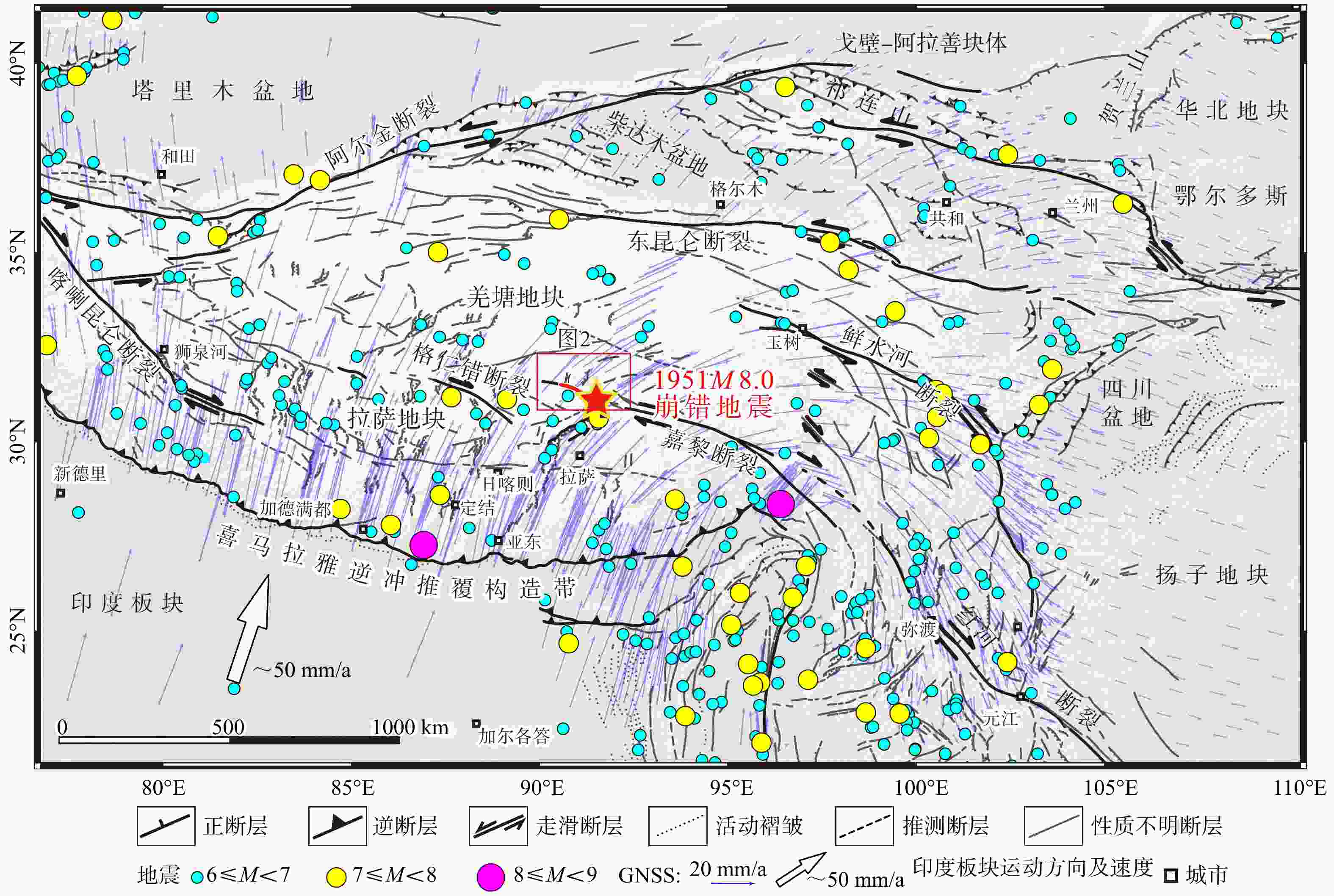
图 1 青藏高原及周边活动构造和地震分布图(青藏高原活动断裂分布图据Tapponnier et al.,2001修改;GPS数据引自Wang and Shen,2020;地震数据(1900年1月—2026年1月)引自 U.S.Geological Survey, 2026)
Figure 1. Map of active tectonics and earthquakes on the Tibetan Plateau and adjacent areas (active faults on the Tibetan Plateau modified from Tapponnier et al., 2001; GPS data from Wang and Shen, 2020; Earthquake data (January 1900 to January 2026) from U.S. Geological Survey, 2026)
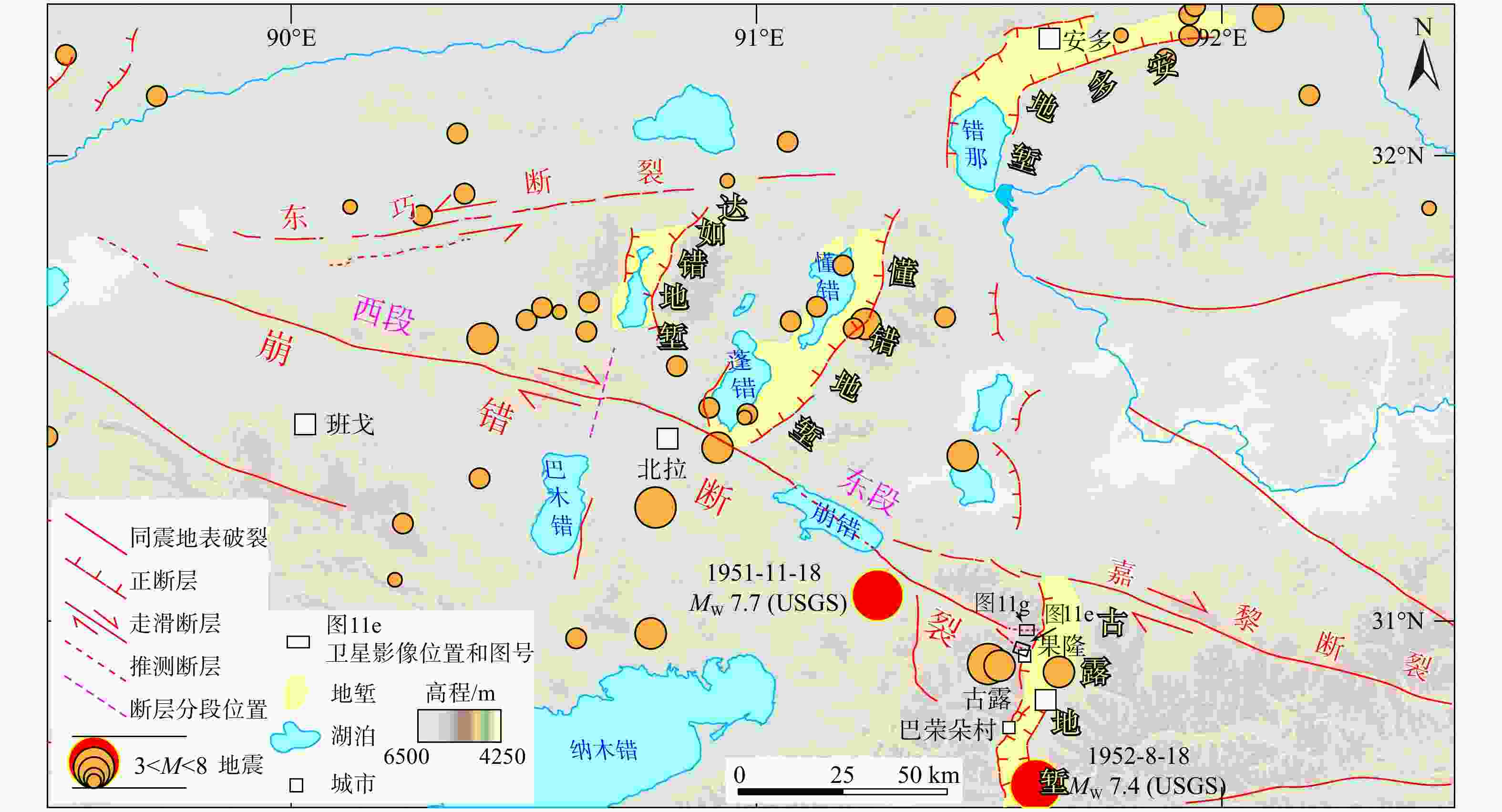
图 2 崩错断裂及附近活动断裂分布图
USGS—美国地质调查局
Figure 2. Map of the Beng Co fault and adjacent active faults
USGS—U.S. Geological Survey
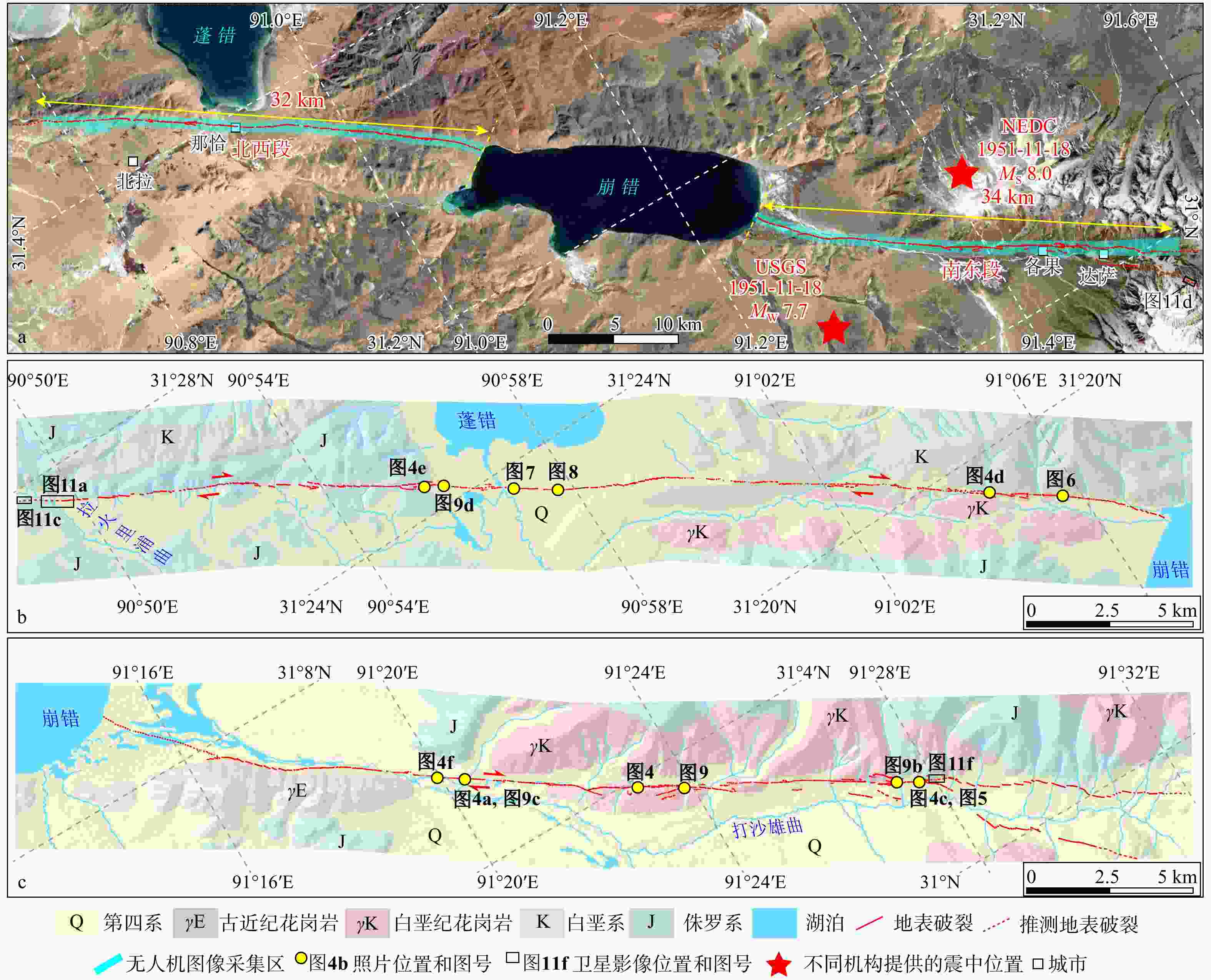
图 3 崩错M 8.0地震同震地表破裂带分布图
a—崩错M 8.0地震同震地表破裂分段及无人机测区范围(底图为Google Earth影像;NEDC代表国家地震科学数据中心;USGS代表美国地质调查局);b—北西段地质简图及同震地表破裂分布图;c—南东段地质简图及同震地表破裂分布图
Figure 3. Distribution of the coseismic surface rupture zone of the Beng Co M 8.0 earthquake
(a) Segmentation of coseismic surface ruptures of the Beng Co M 8.0 earthquake and the UAV survey area (base map from Google Earth imagery; NEDC stands for the National Earthquake Data Science Center; USGS stands for the U.S. Geological Survey); (b) Simplified geological map with coseismic surface rupture distribution in the northwestern section; (c) Simplified geological map with coseismic surface rupture distribution in the southeastern section
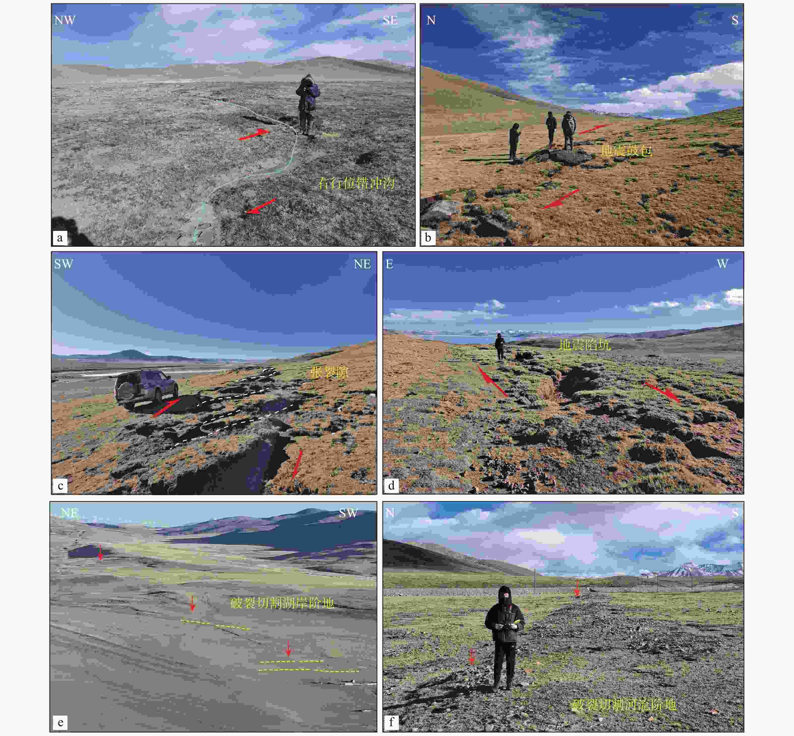
图 4 基于无人机影像解译和野外调查的崩错地震地表破裂带典型特征
图a—d中红色箭头指示断裂两盘右行位错运动方向a—右行位错量~2 m的冲沟;b—左阶排列破裂阶区形成的地震鼓包;c—雁行状排列的张裂隙;d—右阶排列破裂阶区形成的地震陷坑;e—地表破裂切割蓬错多级湖岸阶地;f—破裂切割河流阶地
Figure 4. Field photos showing typical characteristics of the surface rupture zone of the Beng Co earthquake interpreted from UAV imagery and field investigation
(a) A gully with a right-lateral offset of ~2 m; (b) Push-ups formed in a left-stepping rupture step-over; (c) En-echelon tension cracks; (d) Pull-aparts formed in a right-stepping rupture step-over; (e) Multiple lacustrine terraces of Peng Co cut by surface ruptures; (f) River terrace of Dashaxiongqu River cut by surface ruptures Red arrows in panels a–d indicate the right-lateral slip direction between two fault blocks.
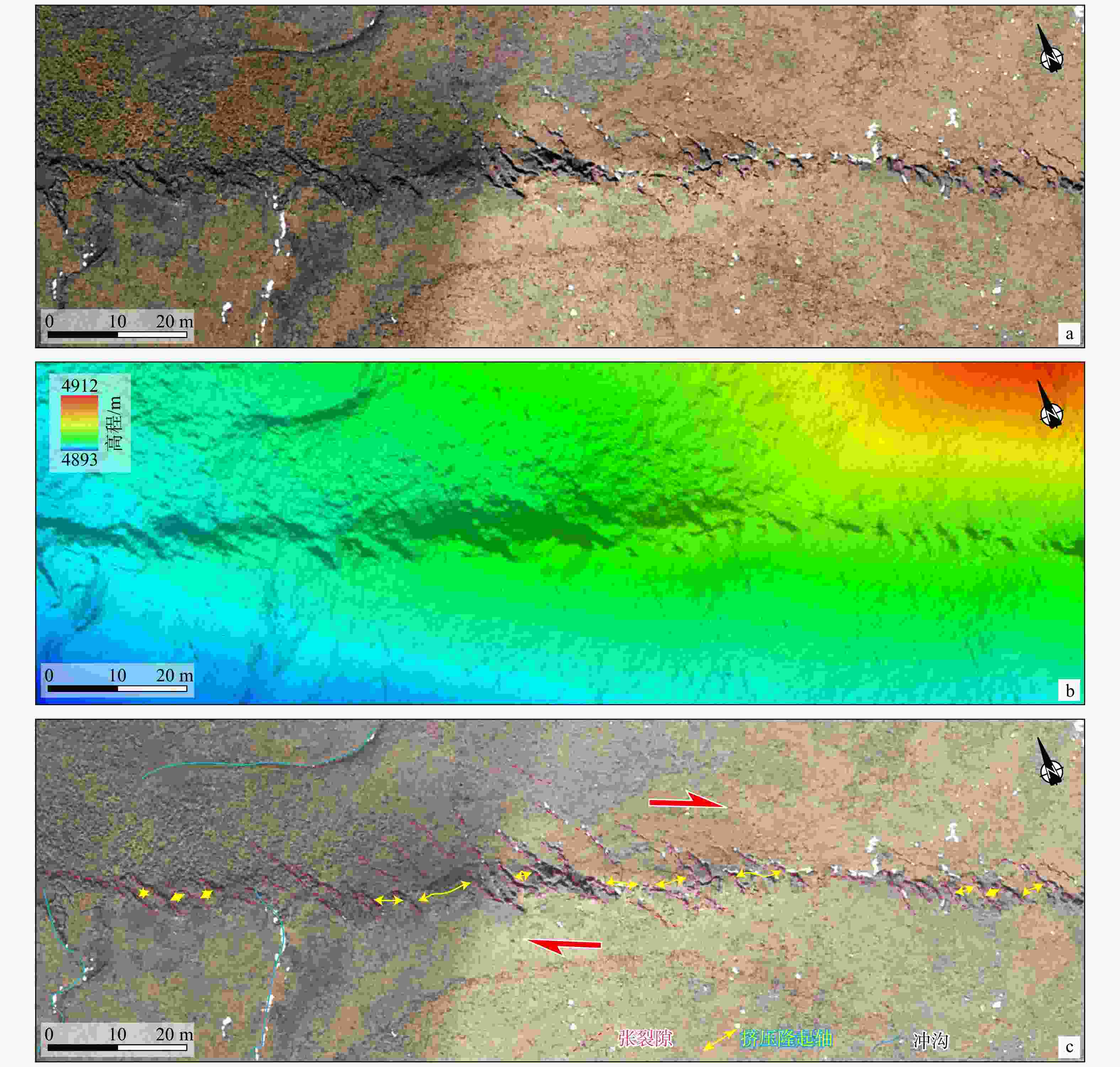
图 5 南东段张裂隙和挤压脊地貌特征
图c中红色箭头指示断裂两盘右行位错运动方向a—张裂隙和挤压脊正射影像;b—张裂隙和挤压脊DEM山影图;c—张裂隙和挤压脊构造地貌解译
Figure 5. Geomorphological features of tension cracks and pressure ridges along the southeastern segment
(a) UAV orthophoto of tension cracks and pressure ridges; (b) Hill-shaded DEM image of tension cracks and pressure ridges; (c) Tectonic geomorphological interpretation of tension cracks and pressure ridges Red arrows in panel c indicate the right-lateral slip direction between two fault blocks.
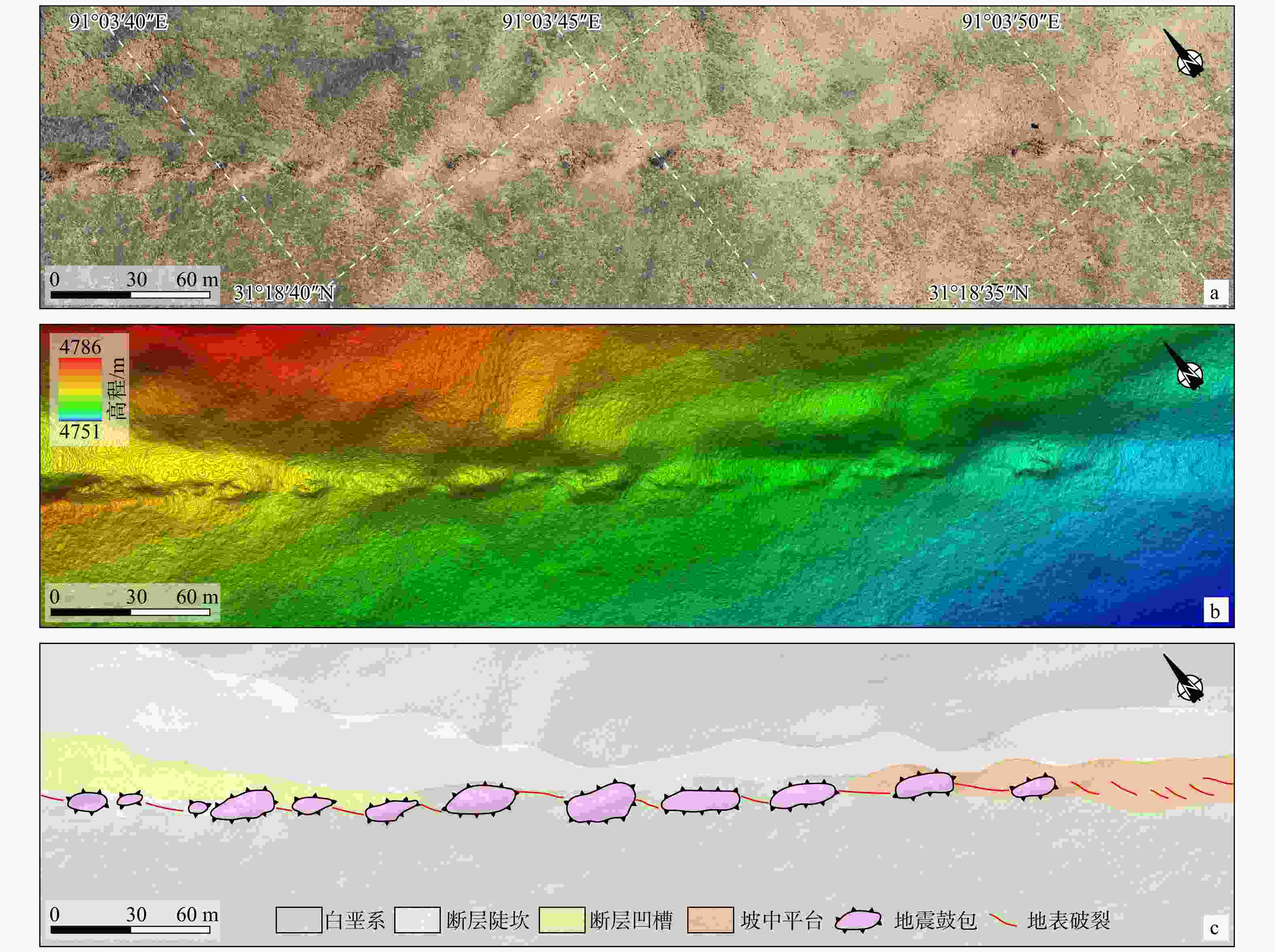
图 6 北西段线性分布的地震鼓包地貌特征
a—线性地震鼓包无人机正射影像;b—线性地震鼓包DEM山影图;c—线性地震鼓包构造地貌解译
Figure 6. Geomorphological features of linearly distributed push-ups along northwestern segment
(a) UAV orthophoto of linearly distributed push-ups; (b) Hill-shaded DEM image of linearly distributed push-ups; (c) Tectonic geomorphological interpretation of linearly distributed push-ups
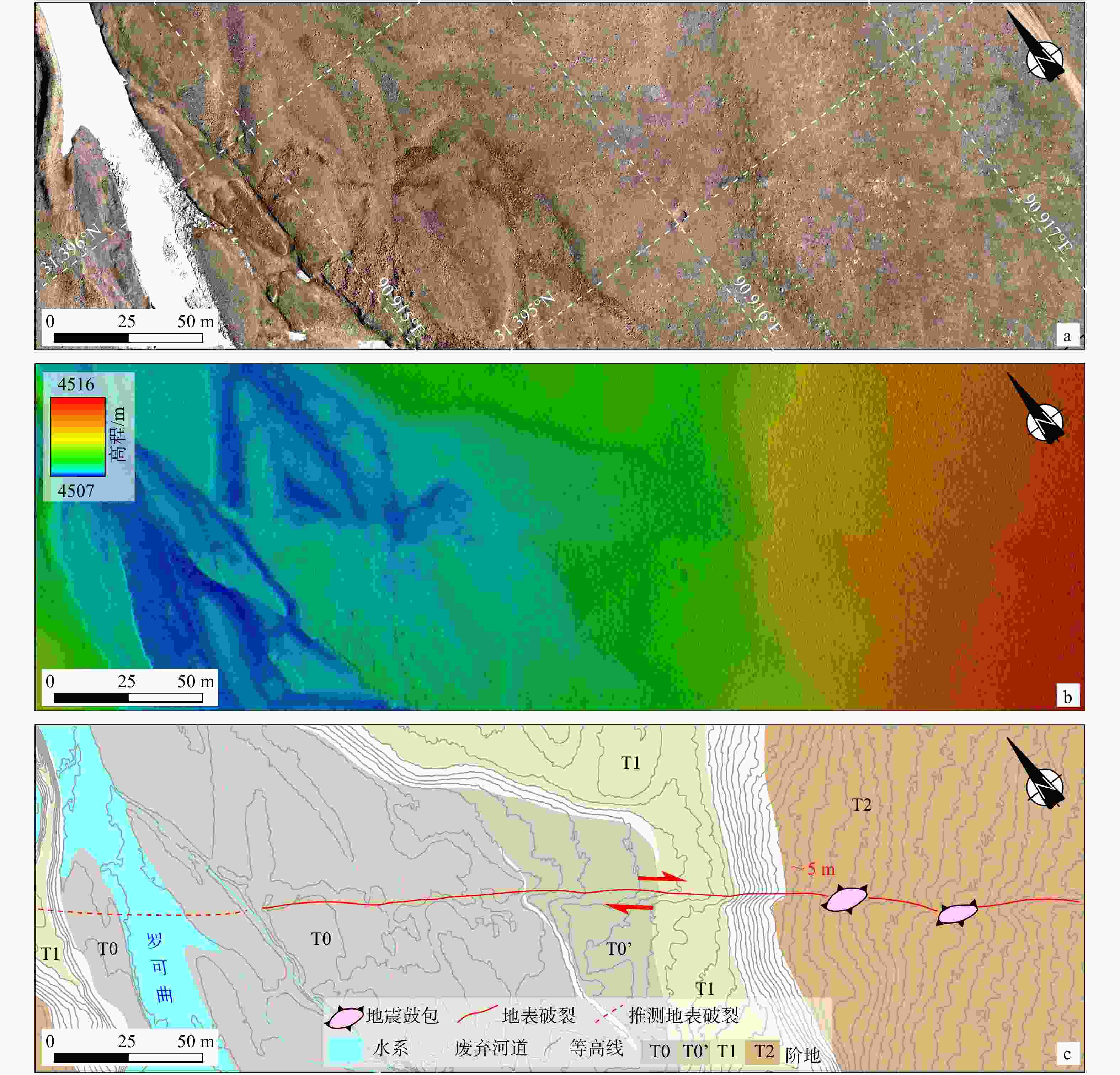
图 7 蓬错南右行位错河流阶地陡坎地貌特征
图c中红色箭头指示断裂两盘右行位错运动方向,数值~5 m为河流阶地边缘实测右行位错距离a—右行位错河流阶地陡坎无人机正射影像;b—右行位错河流阶地陡坎DEM山影图;c—右行位错河流阶地陡坎构造地貌解译
Figure 7. Geomorphological features of right-offset terrace riser on the southern side of Peng Co
(a) UAV orthophoto of right-offset river terrace risers; (b) Hill-shaded DEM image of right-offset river terrace risers; (c) Tectonic geomorphological interpretation of right-offset river terrace risers Red arrows in panel c indicate the right-lateral slip direction between two fault blocks. The numerical value of ~5 m represents the measured right-offset along the river terrace margins.

图 8 蓬错南位错湖岸阶地地貌特征
图c中红色箭头指示断裂两盘右行位错运动方向,~8 m、~9 m和~9 m分别为湖岸阶地边缘实测右行位错距离a—右行位错湖岸阶地无人机正射影像;b—右行位错湖岸阶地DEM山影图;c—右行位错湖岸阶地构造地貌解译
Figure 8. Geomorphological features of offset lacustrine terraces on the southern side of Peng Co
(a) UAV orthophoto of right-offset lacustrine terraces; (b) Hill-shaded DEM image of right-offset lacustrine terraces; (c) Tectonic geomorphological interpretation of right-offset lacustrine terraces Red arrows in panel c indicate the right-lateral slip direction between two fault blocks. Numerical values (~8 m, ~9 m and ~9 m) denote measured right-offset of lacustrine terrace margins, respectively.
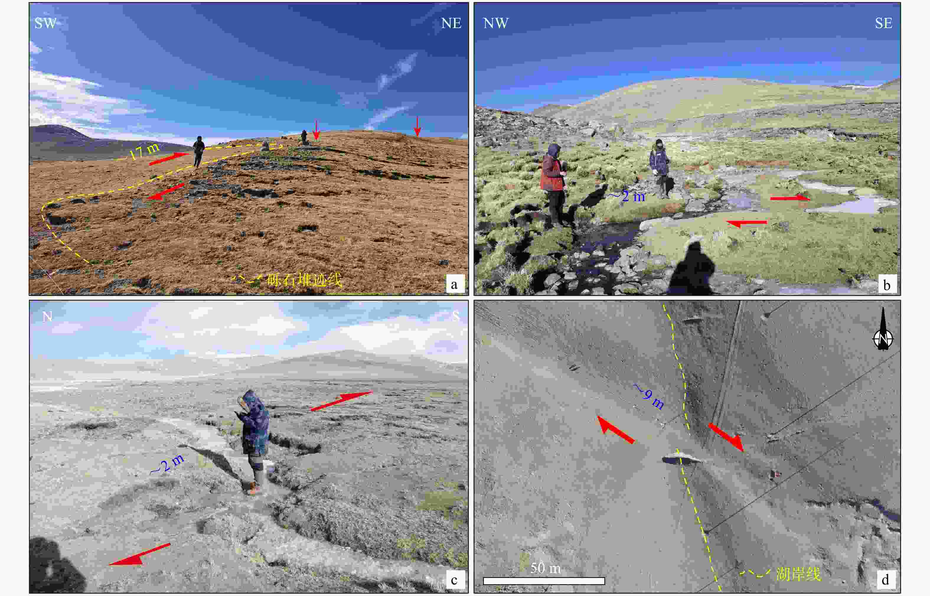
图 9 典型右行位错地貌标志野外照片
a—砾石堆被右行位错~17 m;b—达萨村附近冲沟被右行位错~2 m;c—康托村附近冲沟被右行位错~2 m;d—湖岸线被右行位错~9 m
Figure 9. Field photos of geomorphical markers with right-lateral offset
(a) ~17 m right-lateral offset of a gravel pile; (b) ~2 m right-lateral offset of a a gully near Dasa village; (c) ~2 m right-lateral offset of a gully near Kangtuo village; (d) ~9 m right-lateral offset of a shoreline
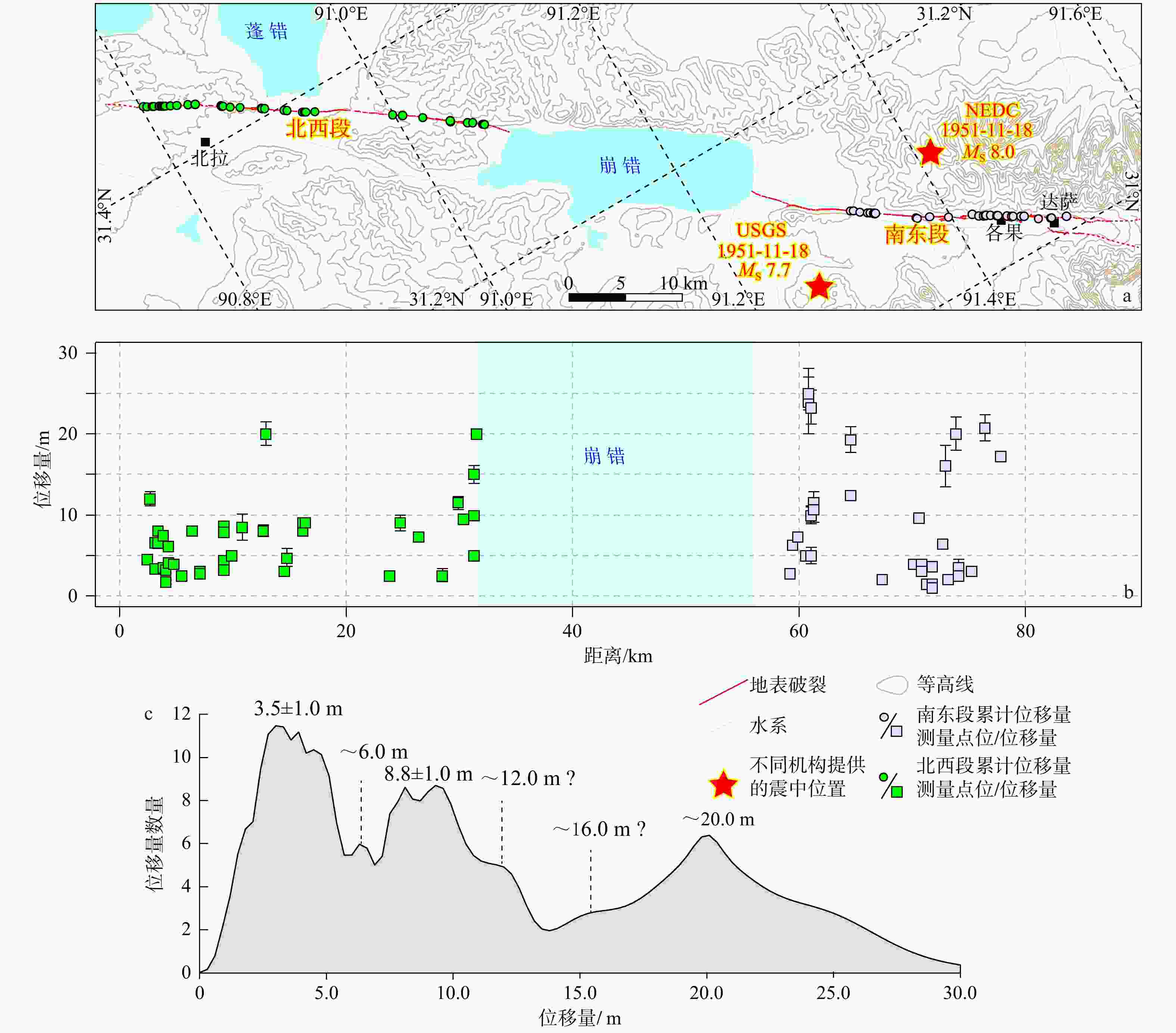
图 10 沿地表破裂带的累积位移量丛集
NEDC—国家地震科学数据中心;USGS—美国地质调查局a—沿破裂带累积位移量测量点分布;b—沿破裂带小于30 m的累积位移量测量结果(每个点代表一个位错的冲沟或阶地陡坎);c—小于30 m的累积位移量概率密度分布函数
Figure 10. Inventory of cumulative offsets along the surface rupture zone of the Beng Co earthquake
(a) Distribution of measured points of cumulative offsets along the rupture zone; (b) Measured cumulative offsets (<30 m) along the rupture zone (Each point represents an offset channel or a terrace riser); (c) Probability density function of cumulative offsets (<30 m) NEDC—National Earthquake Data Science Center; USGS—U.S. Geological Survey
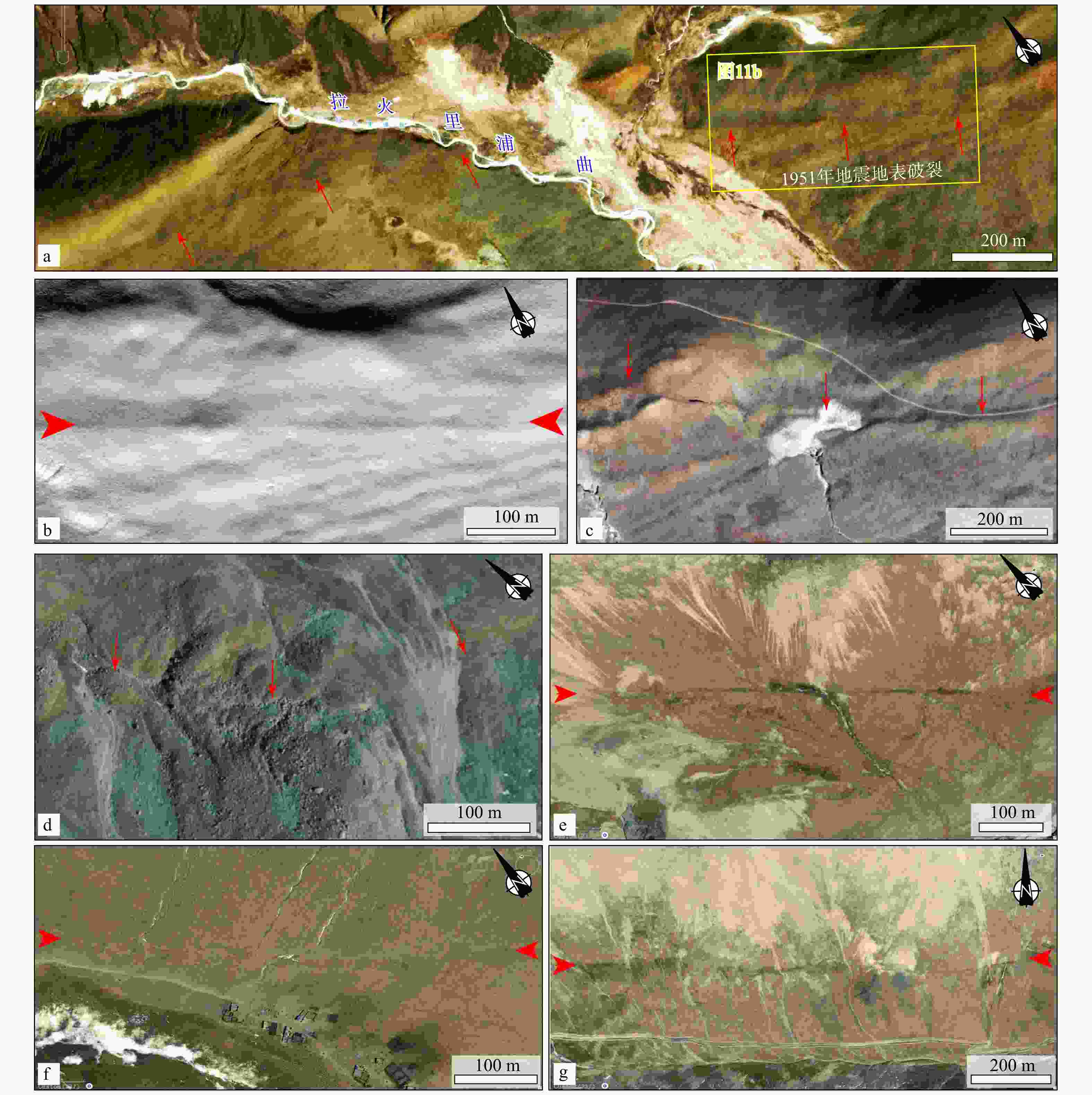
图 11 崩错地震同震地表破裂尾端构造地貌
a—北西端必应地图影像图(Microsoft,2025;箭头指示线性构造);b—拉火里浦曲东侧线性地表破裂DEM影像;c—拉火里浦曲西侧线性构造;d—南东端南支断裂切割冰碛物;e—南东端南支断裂沿山坡展布;f—南东端北支断裂切割冲沟(箭头指示线性构造);g—南东端北支断裂沿山坡展布
Figure 11. Tectonic geomorphology at the end of the surface rupture zone deformed by the Beng Co earthquake
(a) Bing Maps image (Microsoft, 2025) at the northwestern end, with arrows indicating linear structures; (b) DEM image of linear surface rupture on the eastern side of Lahuolipuqu; (c) Linear structure on the western side of Lahuolipuqu; (d) The glacial deposits cut by the southern branch fault at the southeast end; (e) The southern branch fault at the southeast end extending along the slope; (f) The northern branch fault at the southeast end cutting through gullies, with arrows indicating linear structures; (g) The northern branch fault at the southeast end extending along the slope
-
[1] ARMIJO R, TAPPONNIER P, MERCIER J L, et al., 1986. Quaternary extension in southern Tibet: field observations and tectonic implications[J]. Journal of Geophysical Research: Solid Earth, 91(B14): 13803-13872. doi: 10.1029/JB091iB14p13803 [2] ARMIJO R, TAPPONNIER P, HAN T L, 1989. Late Cenozoic right‐lateral strike‐slip faulting in southern Tibet[J]. Journal of Geophysical Research: Solid Earth, 94(B3): 2787-2838. doi: 10.1029/JB094iB03p02787 [3] BI H Y, ZHENG W J, LEI Q Y, et al., 2020. Surface slip distribution along the west Helanshan Fault, northern China, and its implications for fault behavior[J]. Journal of Geophysical Research: Solid Earth, 125(7): e2020JB019983. doi: 10.1029/2020JB019983 [4] BIASI G P, WELDON II R J, 2006. Estimating surface rupture length and magnitude of paleoearthquakes from point measurements of rupture displacement[J]. Bulletin of the Seismological Society of America, 96(5): 1612-1623. doi: 10.1785/0120040172 [5] CHEVALIER M L, TAPPONNIER P, VAN DER WOERD J, et al., 2020. Late quaternary extension rates across the northern half of the Yadong-Gulu Rift: implication for east-west extension in southern Tibet[J]. Journal of Geophysical Research: Solid Earth, 125(7): e2019JB019106. doi: 10.1029/2019JB019106 [6] DE PASCALE G P, QUIGLEY M C, DAVIES T R H, 2014. Lidar reveals uniform Alpine fault offsets and bimodal plate boundary rupture behavior, New Zealand[J]. Geology, 42(5): 411-414. doi: 10.1130/G35100.1 [7] DENG Q D, YU G H, YE W H. 1992. Relationship between earthquake magnitude and parameters of surface ruptures associated with historical earthquakes[M]//Research of Active Fault. Beijing: Seismological Press: 247-264. (in Chinese) [8] ELLIOTT J R, WALTERS R J, ENGLAND P C, et al., 2010. Extension on the Tibetan plateau: recent normal faulting measured by InSAR and body wave seismology[J]. Geophysical Journal International, 183(2): 503-535. doi: 10.1111/j.1365-246X.2010.04754.x [9] GARTHWAITE M C, WANG H, WRIGHT T J, 2013. Broadscale interseismic deformation and fault slip rates in the central Tibetan Plateau observed using InSAR[J]. Journal of Geophysical Research: Solid Earth, 118(9): 5071-5083. doi: 10.1002/jgrb.50348 [10] GU G X. 1983. Catalogue of earthquakes in China[M]. Beijing: Science Press. (in Chinese) [11] HAN S, LI H B, PAN J W, et al., 2019. Co-seismic surface ruptures in Qiangtang Terrane: insight into Late Cenozoic deformation of central Tibet[J]. Tectonophysics, 750: 359-378. doi: 10.1016/j.tecto.2018.11.001 [12] HAN T L, 1983. Preliminary investigation of deformation belts caused by earthquakes in 1951—1952 in the Dangxiong-Bengcuo area of Tibet[J]. Seismology and Geology, 5(4): 1-11. (in Chinese with English abstract) [13] HARRISON T M, COPELAND P, KIDD W S F, et al., 1992. Raising Tibet[J]. Science, 255(5052): 1663-1670. doi: 10.1126/science.255.5052.1663 [14] Institute of Geology, China Earthquake Administration, 1992. Active faults in the central Tibet[M]. Beijing: Seismological Press: 154. (in Chinese) [15] JIANG C Y, PAN J W, ZHANG L J, et al., 2024. Application of UAV SfM technology in active tectonic research: a case study of the Longmu Co Fault, Northwestern Qinghai-Tibet Plateau[J]. Journal of Geomechanics, 30(2): 332-347. (in Chinese with English abstract) [16] JOHNSON K, NISSEN E, SARIPALLI S, et al., 2014. Rapid mapping of ultrafine fault zone topography with structure from motion[J]. Geosphere, 10(5): 969-986. doi: 10.1130/GES01017.1 [17] KANEDA H, NAKATA T, TSUTSUMI H, et al., 2008. Surface rupture of the 2005 Kashmir, Pakistan, earthquake and its active tectonic implications[J]. Bulletin of the Seismological Society of America, 98(2): 521-557. doi: 10.1785/0120070073 [18] KAPP P, TAYLOR M, STOCKLI D, et al., 2008. Development of active low-angle normal fault systems during orogenic collapse: insight from Tibet[J]. Geology, 36(1): 7-10. doi: 10.1130/G24054A.1 [19] KLINGER Y, XU X W, TAPPONNIER P, et al., 2005. High-resolution satellite imagery mapping of the surface rupture and slip distribution of the MW 7.8, 14 November 2001 Kokoxili earthquake, Kunlun Fault, northern Tibet, China[J]. Bulletin of the Seismological Society of America, 95(5): 1970-1987. doi: 10.1785/0120040233 [20] KLINGER Y, ETCHEBES M, TAPPONNIER P, et al., 2011. Characteristic slip for five great earthquakes along the Fuyun fault in China[J]. Nature Geoscience, 4(6): 389-392. doi: 10.1038/ngeo1158 [21] LI H B, WANG Z X, FU X F, et al., 2008. The surface rupture zone distribution of the Wenchuan earthquake (MS8.0) happened on May 12th, 2008[J]. Geology in China, 35(5): 803-813. (in Chinese with English abstract) [22] LI H B, VAN DER WOERD J, SUN Z M, et al., 2012. Co-seismic and cumulative offsets of the recent earthquakes along the Karakax left-lateral strike-slip fault in western Tibet[J]. Gondwana Research, 21(1): 64-87. doi: 10.1016/j.gr.2011.07.025 [23] LI H B, PAN J W, SUN Z M, et al., 2021. Continental tectonic deformation and seismic activity: a case study from the Tibetan Plateau[J]. Acta Geologica Sinica, 95(1): 194-213. (in Chinese with English abstract) [24] LI K, KIRBY E, XU X W, et al., 2019. Rates of Holocene normal faulting along the Dong Co fault in central Tibet, based on 14C dating of displaced fluvial terraces[J]. Journal of Asian Earth Sciences, 183: 103962. doi: 10.1016/j.jseaes.2019.103962 [25] LI K, TAPPONNIER P, XU X W, et al., 2022. Holocene slip rate along the Beng Co Fault and dextral strike-slip extrusion of central eastern Tibet[J]. Tectonics, 41(8): e2022TC007230. doi: 10.1029/2022TC007230 [26] LI K, CHEVALIER M L, TAPPONNIER P, et al., 2024. Previously unrecognized, 1000 km-long Qixiang Co fault governs eastward escape of central Tibet[J]. Earth and Planetary Science Letters, 644: 118928. doi: 10.1016/j.epsl.2024.118928 [27] LI Y S, TIAN Y F, YU C, et al., 2020. Present-day interseismic deformation characteristics of the Beng Co-Dongqiao conjugate fault system in central Tibet: implications from InSAR observations[J]. Geophysical Journal International, 221(1): 492-503. doi: 10.1093/gji/ggaa014 [28] LIU F C, PAN J W, LI H B, et al., 2025. Co-seismic surface rupture of the 2025 MW7.1 Tingri earthquake and potential seismic risk in southern Tibetan Plateau[J]. Acta Geologica Sinica, 99(3): 685-703. (in Chinese with English abstract) [29] LIU-ZENG J, YAO W Q, LIU X L, et al., 2022. High-resolution structure-from-motion models covering 160 km-long surface ruptures of the 2021 MW 7.4 Madoi earthquake in northern Qinghai-Tibetan Plateau[J]. Earthquake Research Advances, 2(2): 100140. doi: 10.1016/j.eqrea.2022.100140 [30] MANIGHETTI I, PERRIN C, DOMINGUEZ S, et al., 2015. Recovering paleoearthquake slip record in a highly dynamic alluvial and tectonic region (Hope Fault, New Zealand) from airborne lidar[J]. Journal of Geophysical Research: Solid Earth, 120(6): 4484-4509. doi: 10.1002/2014JB011787 [31] MCGILL S F, SIEH K, 1991. Surficial offsets on the Central and Eastern Garlock Fault associated with prehistoric earthquakes[J]. Journal of Geophysical Research: Solid Earth, 96(B13): 21597-21621. doi: 10.1029/91JB02030 [32] Microsoft, 2025. Bing Maps satellite imagery[EB/OL]. [2025-11-01]. https://www.bing.com/maps. [33] MOLNAR P, TAPPONNIER P, 1975. Cenozoic Tectonics of Asia: Effects of a Continental Collision: Features of recent continental tectonics in Asia can be interpreted as results of the India-Eurasia collision[J]. Science, 189(4201): 419-426. doi: 10.1126/science.189.4201.419 [34] MOLNAR P, TAPPONNIER P, 1978. Active tectonics of Tibet[J]. Journal of Geophysical Research: Solid Earth, 83(B11): 5361-5375. doi: 10.1029/JB083iB11p05361 [35] NI J, YORK J E, 1978. Late Cenozoic tectonics of the Tibetan Plateau[J]. Journal of Geophysical Research: Solid Earth, 83(B11): 5377-5384. doi: 10.1029/JB083iB11p05377 [36] PAN J W, LI H B, SI J L, et al. , 2014. Rupture process of the Wenchuan earthquake (MW 7.9) from surface ruptures and fault striations characteristics[J]. Tectonophysics, 619-620: 13-28. [37] PAN J W, BAI M K, LI C, et al., 2021. Coseismic surface rupture and seismogenic structure of the 2021-05-22 Maduo (Qinghai) MS 7.4 earthquake[J]. Acta Geologica Sinica, 95(6): 1655-1670. (in Chinese with English abstract) [38] PAN J W, LI H B, CHEVALIER M L, et al., 2022. Coseismic surface rupture and seismogenic structure of the 2022 MS 6.9 Menyuan earthquake, Qinghai Province, China[J]. Acta Geologica Sinica (100th Anniversary), 96(1): 215-231. (in Chinese with English abstract) [39] QUIGLEY M, VAN DISSEN R, LITCHFIELD N, et al., 2012. Surface rupture during the 2010 MW 7.1 Darfield (Canterbury) earthquake: implications for fault rupture dynamics and seismic-hazard analysis[J]. Geology, 40(1): 55-58. doi: 10.1130/G32528.1 [40] REN Z K, ZHANG Z Q, CHEN T, et al., 2016. Clustering of offsets on the Haiyuan fault and their relationship to paleoearthquakes[J]. GSA Bulletin, 128(1-2): 3-18. doi: 10.1130/b31155.1 [41] REN Z K, ZHANG Z Q, 2019. Structural analysis of the 1997 MW 7.5 Manyi earthquake and the kinematics of the Manyi fault, central Tibetan Plateau[J]. Journal of Asian Earth Sciences, 179: 149-164. doi: 10.1016/j.jseaes.2019.05.003 [42] ROYDEN L H, BURCHFIEL B C, VAN DER HILST R D, 2008. The geological evolution of the Tibetan Plateau[J]. Science, 321(5892): 1054-1058. doi: 10.1126/science.1155371 [43] SALISBURY J B, ROCKWELL T K, MIDDLETON T J, et al., 2012. LiDAR and field observations of slip distribution for the most recent surface ruptures along the central San Jacinto Fault[J]. Bulletin of the Seismological Society of America, 102(2): 598-619. doi: 10.1785/0120110068 [44] SHAO Y X, WANG A S, LIU-ZENG J, et al., 2025. Preliminary investigation on surface rupture and coseismic displacement of the January 7, 2025 Dingri earthquake in Xizang[J]. Earth Science, 50(5): 1677-1695. (in Chinese with English abstract) [45] TAPPONNIER P, PELTZER G, LE DAIN A Y, et al., 1982. Propagating extrusion tectonics in Asia: new insights from simple experiments with plasticine[J]. Geology, 10(12): 611-616. doi: 10.1130/0091-7613(1982)10<611:petian>2.0.co;2 [46] TAPPONNIER P, ZHIQIN X, ROGER F, et al., 2001. Oblique stepwise rise and growth of the Tibet plateau[J]. Science, 294(5547): 1671-1677. doi: 10.1126/science.105978 [47] TAYLOR M, YIN A, RYERSON F J, et al., 2003. Conjugate strike-slip faulting along the Bangong-Nujiang suture zone accommodates coeval east-west extension and north-south shortening in the interior of the Tibetan Plateau[J]. Tectonics, 22(4): 1044. doi: 10.1029/2002tc001361 [48] TAYLOR M, PELTZER G, 2006. Current slip rates on conjugate strike-slip faults in central Tibet using synthetic aperture radar interferometry[J]. Journal of Geophysical Research: Solid Earth, 111(B12): B12402. doi: 10.1029/2005jb004014 [49] TAYLOR M, YIN A, 2009. Active structures of the Himalayan-Tibetan orogen and their relationships to earthquake distribution, contemporary strain field, and Cenozoic volcanism[J]. Geosphere, 5(3): 199-214. doi: 10.1130/GES00217.1 [50] TIAN Y F, LIU-ZENG J, FENG W P, et al., 2026. Deformation pattern and slip rate of the Karakorum-Jiali Fault Zone in Southeastern Tibet from Sentinel-1 InSAR[J]. Tectonophysics, 918: 230976. doi: 10.1016/j.tecto.2025.230976 [51] U. S. Geological Survey, 1951[2026-2-1]. M 7.7 - 89 km WSW of Nagqu, China[EB/OL]. https://earthquake.usgs.gov/earthquakes/eventpage/iscgem894960/executive. [52] U. S. Geological Survey, 2026[2026-2-1]. Earthquake hazards program[EB/OL]. https://earthquake.usgs.gov/. [53] WELLS D L, COPPERSMITH K J, 1994. New empirical relationships among magnitude, rupture length, rupture width, rupture area, and surface displacement[J]. Bulletin of the Seismological Society of America, 84(4): 974-1002. doi: 10.1785/BSSA0840040974 [54] WANG M, SHEN Z K, 2020. Present-day crustal deformation of continental China derived from GPS and its tectonic implications[J]. Journal of Geophysical Research: Solid Earth, 125(2): e2019JB018774. doi: 10.1029/2019JB018774 [55] WU Z H, WU Z H, HU D G, et al., 2006. Holocene seismogenic faults along the Tanggula-Lhasa section of the Qinghai-Tibet Railway, China[J]. Geological Bulletin of China, 25(12): 1387-1401. (in Chinese with English abstract) [56] WU Z M, DENG Q D, 1989. Deformation features and fracture mechanism of surface rupture of 1951 Bengco, Tibet MS=8 earthquake[J]. Seismology and Geology, 11(1): 15-25. (in Chinese with English abstract) [57] YANG G, WU J C, HU Q, et al., 2019. Effects of static stress triggering of the strongest earthquakes along the Bengco—southeastern Piedmont of Nyainqentanglha mountain fault zone, Tibet[J]. Journal of Seismology, 23(4): 943-950. doi: 10.1007/s10950-019-09841-2 [58] YIN A, TAYLOR M H, 2011. Mechanics of V-shaped conjugate strike-slip faults and the corresponding continuum mode of continental deformation[J]. Geological Society of America Bulletin, 123(9-10): 1798-1821. doi: 10.1130/B30159.1 [59] ZHANG D C, 1988. Intensity distribution of the 1951 Dangxiong earthquake and its characteristics of seismical deformation[J]. Earthquake Research in China, 4(4): 62-67. (in Chinese with English abstract) [60] ZHANG P Z, WANG W T, GAN W J, et al., 2022. Present-day deformation and geodynamic processes of the Tibetan Plateau[J]. Acta Geologica Sinica, 96(10): 3297-3313. (in Chinese with English abstract) [61] ZIELKE O, ARROWSMITH J R, LUDWIG L G, et al., 2010. Slip in the 1857 and earlier large earthquakes along the Carrizo Plain, San Andreas Fault[J]. Science, 327(5969): 1119-1122. doi: 10.1126/science.1182781 [62] ZIELKE O, ARROWSMITH J R, 2012. LaDiCaoz and LiDARimager—MATLAB GUIs for LiDAR data handling and lateral displacement measurement[J]. Geosphere, 8(1): 206-221. [63] ZIELKE O, KLINGER Y, ARROWSMITH J R, 2015. Fault slip and earthquake recurrence along strike-slip faults — Contributions of high-resolution geomorphic data[J]. Tectonophysics, 638: 43-62. doi: 10.1016/j.tecto.2014.11.004 [64] 邓起东, 于贵华, 叶文华. 1992. 地震地表破裂参数与震级关系的研究[M]//活动断裂研究. 北京: 地震出版社: 247-264. [65] 顾功叙. 1983. 中国地震目录[M]. 北京: 科学出版社. [66] 国家地震局地质研究所, 1992. 西藏中部活动断层[M]. 北京: 地震出版社: 154. [67] 韩同林, 1983. 西藏当雄—崩错一带1951—1952年地震形变带的初步考察[J]. 地震地质, 5(4): 1-11. [68] 江晨轶, 潘家伟, 张丽军, 等, 2024. UAV SfM技术在活动构造研究中的应用: 以青藏高原西北部龙木错断裂为例[J]. 地质力学学报, 30(2): 332-347. doi: 10.12090/j.issn.1006-6616.2023192 [69] 李海兵, 王宗秀, 付小方, 等, 2008. 2008年5月12日汶川地震(MS8.0)地表破裂带的分布特征[J]. 中国地质, 35(5): 803-813. doi: 10.3969/j.issn.1000-3657.2008.05.002 [70] 李海兵, 潘家伟, 孙知明, 等, 2021. 大陆构造变形与地震活动: 以青藏高原为例[J]. 地质学报, 95(1): 194-213. [71] 刘富财, 潘家伟, 李海兵, 等, 2025. 2025年MW7.1西藏定日地震地表破裂与同震位移分布特征[J]. 地质学报, 99(3): 685-703. doi: 10.19762/j.cnki.dizhixuebao.2025069 [72] 潘家伟, 白明坤, 李超, 等, 2021. 2021年5月22日青海玛多MS 7.4地震地表破裂带及发震构造[J]. 地质学报, 95(6): 1655-1670. doi: 10.3969/j.issn.0001-5717.2021.06.001 [73] 潘家伟, 李海兵, CHEVALIER M L, 等, 2022. 2022年青海门源MS 6.9地震地表破裂带及发震构造研究[J]. 地质学报(创刊100周年), 96(1): 215-231. [74] 邵延秀, 王爱生, 刘静, 等, 2025. 2025年1月7日西藏定日地震地表破裂特征和野外同震位移测量初步结果[J]. 地球科学, 50(5): 1677-1695. doi: 10.3799/dqkx.2025.040 [75] 吴章明, 邓起东, 1989. 西藏崩错8级地震地表破裂的变形特征及其破裂机制[J]. 地震地质, 11(1): 15-25. [76] 吴中海, 吴珍汉, 胡道功, 等, 2006. 青藏铁路唐古拉山—拉萨段全新世控震断裂研究[J]. 地质通报, 25(12): 1387-1401. [77] 张德成, 1988. 西藏当雄1951年8.0级地震烈度分布及形变特征[J]. 中国地震, 4(4): 62-67. [78] 张培震, 王伟涛, 甘卫军, 等, 2022. 青藏高原的现今构造变形与地球动力过程[J]. 地质学报, 96(10): 3297-3313. doi: 10.19762/j.cnki.dizhixuebao.2022295 -
 2026016-资源附件.xlsx

-

 下载:
下载:


计量
- 文章访问数: 521
- HTML全文浏览量: 190
- PDF下载量: 183
- 被引次数: 0
