

Tectonic evolution of the Sumatran Fault: synthesis and perspective
-
摘要: 印度–澳大利亚板块向欧亚板块斜向汇聚,导致在仰冲板块形成一条长达1900 km的右行走滑断层——苏门答腊断层。已有研究对该断层进行了几何学、运动学以及地震活动研究但断层的构造演化过程至今并未得到精确的限定。文章围绕苏门答腊断层的演化,综述对苏门答腊断层已有的认识与限定,并在此基础上探讨苏门答腊断层研究的局限性及未来研究方向。苏门答腊断层是一高度分段的右行走滑断层,结合地震−构造特征可分为近20段。苏门答腊断层滑移速率从南至北较一致,为~15 mm/yr,现有结果表明断层的总位移量大约为20~25 km。区域上弧岩浆活动区域与断层展布相互重合,表明岩浆导致的地壳弱化促进了断层的形成,而断层活动产生的空间则又会控制部分岩浆的运移。现有对苏门答腊断层的年代学工作较少,已有的低温年代学数据表明,在2 Ma时期由于断层活动导致了断层附近地壳快速抬升;现今断层活动速率和位移量推算出的断层起始时间与该低温热年代学研究结论较为契合,表明苏门答腊断层在约2 Ma时有一期由于断层倾滑导致的快速隆升事件,代表着苏门答腊断层的贯通和现今构造体系的建立。文章通过整合地质、大地测量、地震活动、岩浆活动、低温年代学等多学科证据,系统梳理了苏门答腊断层的时空演化框架,进一步阐明了断层演化历史及现今构造格局的形成过程。研究结果加深了对斜向俯冲背景下应变分配机制及海沟平行走滑断层形成机制的认识,可为全球类似构造体系的研究及地震灾害评估提供重要参考。Abstract:
Objective Oblique convergence between the Indo-Australian Plate and the Eurasian Plate produced a ~1,900-km-long dextral strike-slip fault—the Sumatran Fault—within the overriding plate. While previous studies have extensively examined its geometry, kinematics, and seismicity, the tectonic evolution of the fault remains poorly constrained. Methods This study integrates multidisciplinary evidence from structural geology, geomorphology, seismicity analysis, geodesy (GPS), low-temperature thermochronology (apatite and zircon (U-Th)/He dating), and volcanic distribution mapping. We systematically synthesize data on fault segmentation, slip rates, cumulative displacement, magmatic-tectonic relationships, and regional geodynamic models to evaluate the fault’s spatiotemporal evolution. Results The Sumatran Fault is a highly segmented dextral strike-slip system that can currently be divided into 19 segments based on geometric complexity and seismic activity. Slip rates along the fault are relatively uniform from south to north, with an average around 15 mm/yr, and a total cumulative displacement of approximately 20~25 km. Regionally, the distribution of active arc magmatism closely aligns with the trace of the fault, indicating a dynamic interaction between faulting and magmatism: while magma-induced crustal weakening facilitates fault development, extensional zones associated with normal faulting in turn influence the volcanic activity. Despite its tectonic significance, low-temperature thermochronological studies on the Sumatran Fault remain limited. Existing thermochronological data reveal a period of rapid uplift at ~2 Ma, likely driven by dip-slip motion along the fault. Conclusions A three-stage model is proposed. Before 2 Ma, oblique convergence was primarily accommodated by forearc faults (e.g., Mentawai Fault) and shear zones. Around 2 Ma, the Sumatran Fault initiated contemporaneously with the Mentawai Fault, manifesting strain localization in the overriding plate. At present, the Sumatran Fault accommodates the majority of the strain, while strike-slip motion on the Mentawai Fault has significantly diminished. The uplift phase correlates with the initial timing of the Sumatran Fault inferred from present-day slip rates and cumulative offsets, suggesting that the current through-going structure of the fault and the modern tectonic framework were established at the same time. [ Significance ] This study provides a comprehensive synthesis of multidisciplinary constraints on the Sumatran Fault and establishes a unified spatiotemporal framework for its tectonic evolution. By integrating fault segmentation, slip rates, thermochronological data, and magmatic–tectonic interactions, this study clarifies the timing of fault initiation and the development of the present-day tectonic architecture. The results offer new insights into strain partitioning and the formation of trench-parallel strike-slip faults at obliquely convergent margins, providing a valuable reference for understanding similar plate boundary systems and their associated seismic hazards. -
Key words:
- Sumatran Fault /
- fault structure /
- tectonic activity /
- oblique subduction /
- geological evolution
-
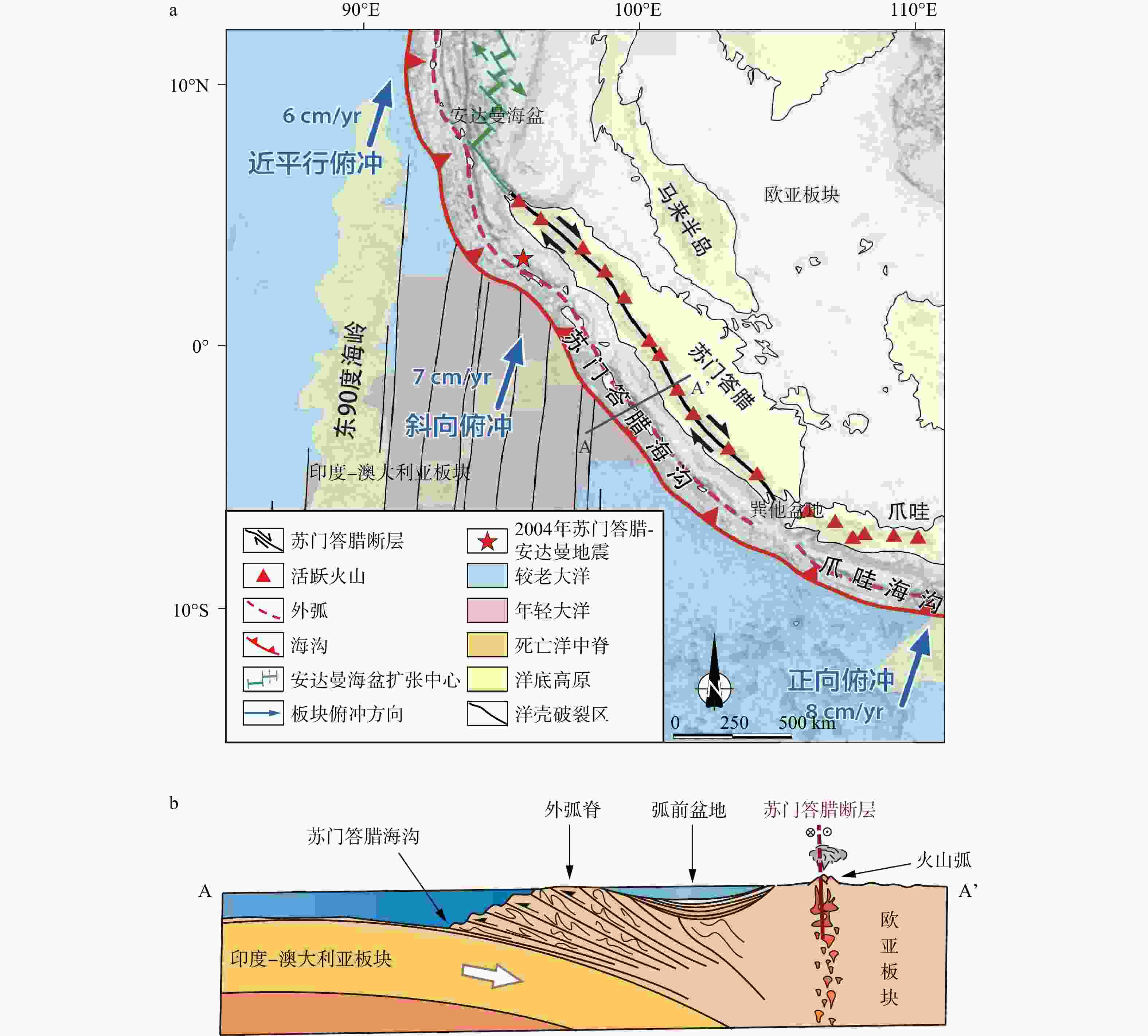
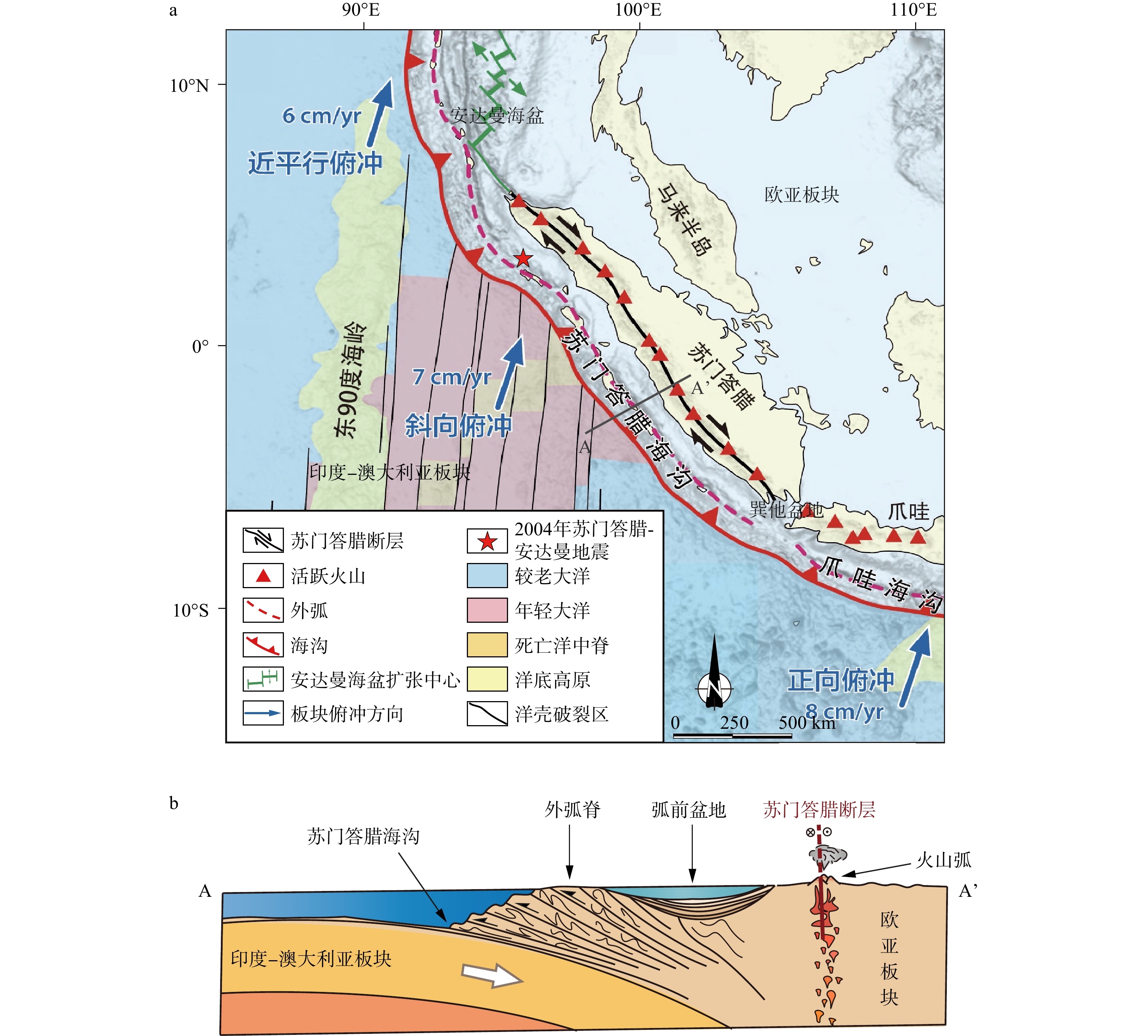
图 1 苏门答腊俯冲带示意图
a—苏门答腊俯冲带构造框架图(据Frisch et al.,2011修改;线段A–A’指示图1b剖面位置);b—苏门答腊俯冲带剖面图(据Frisch et al.,2011修改)
Figure 1. Schematic diagram of the Sumatra subduction zone
(a) The structural framework of the Sumatra subduction zone (modified after Frisch et al., 2011). Line A–A’ indicates the location of the cross section shown in Fig. 1b; (b) Cross-section of the Sumatra subduction zone (modified after Frisch et al., 2011)
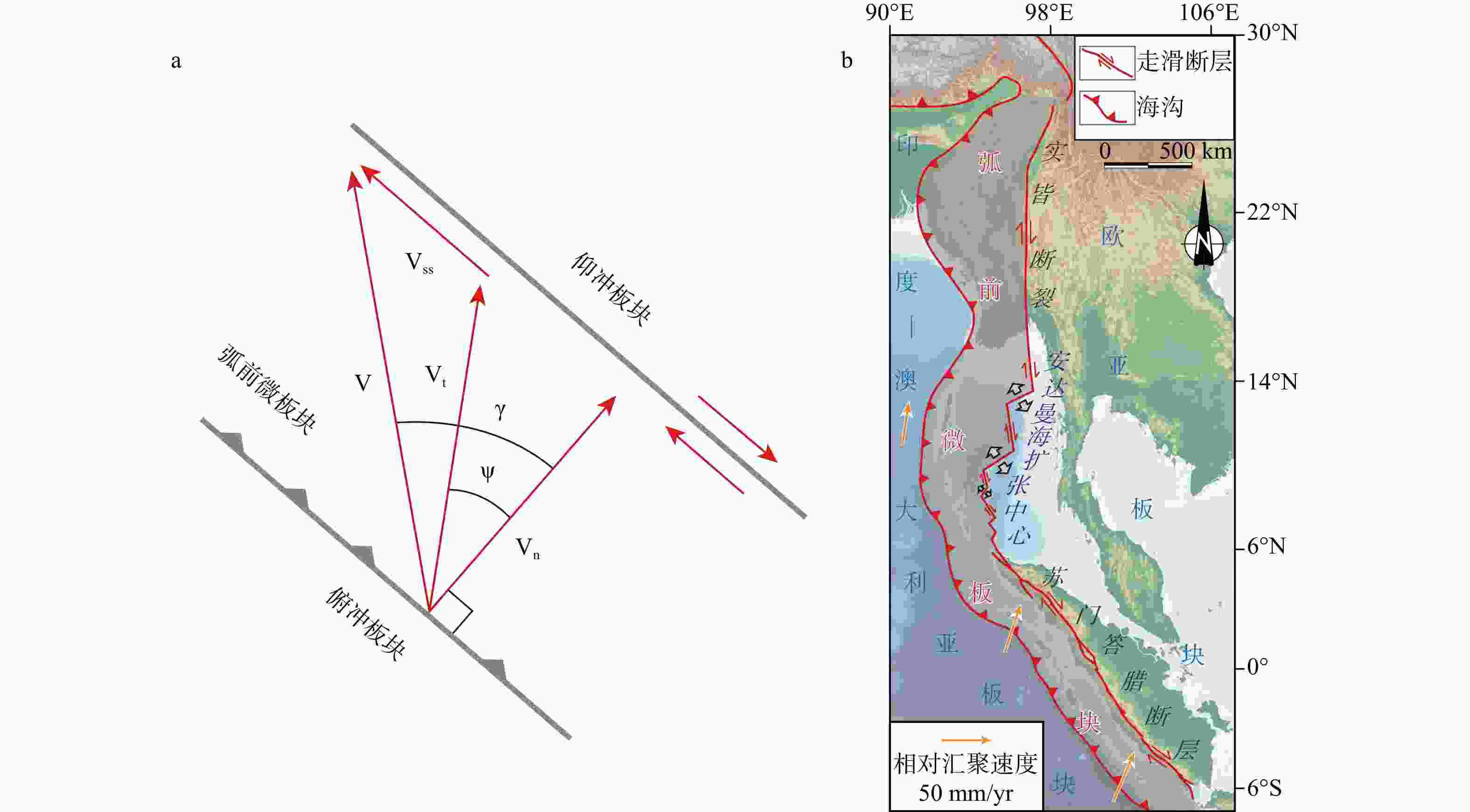
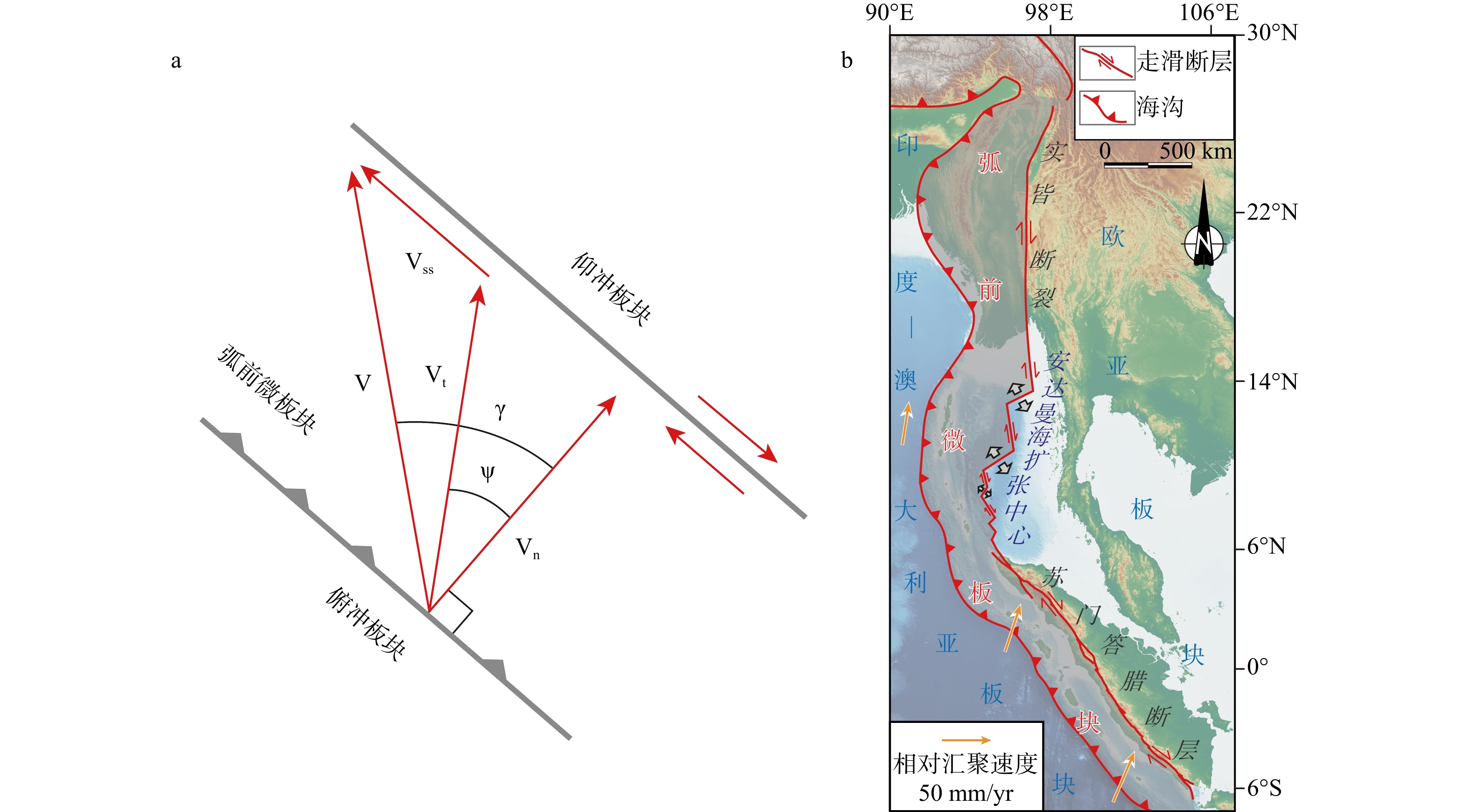
图 2 印度−澳大利亚板块与欧亚板块运动学特征及构造变形响应
a—斜向俯冲板块运动矢量分解模型示意图(据McCaffrey,2009修改;红色箭头指示板块相对运动矢量;V—俯冲板块与仰冲板块相对汇聚速度矢量;Vss—走滑断层滑动速度矢量;Vt—俯冲板块与弧前微板块之间相对汇聚速度矢量;Vn—垂直于海沟走向的汇聚速度矢量;Ψ—俯冲板块与弧前微板块间汇聚斜向度;γ—俯冲板块与仰冲板块间汇聚斜向度);b—东南亚弧前微板块示意图
Figure 2. Kinematics and tectonic deformation responses of the Indo-Australian and Eurasian Plates
(a) Slip partitioning model of oblique subduction (modified after McCaffrey, 2009); (b) Sliver plate diagram of southeast Asia. Red arrows indicate relative plate motion vectors. Total relative motion vector V, the direction of Vss (the strike-slip vector) from fault orientation, and the azimuth of Vt (the thrust vector) from earthquake slip vectors allow a unique solution to the triangle formed by V, Vt, and Vss, providing estimates of the magnitudes of Vt and Vss. Ψ is the slip vector obliquity, γ is the convergence obliquity, and Vn is the velocity normal to the trench.
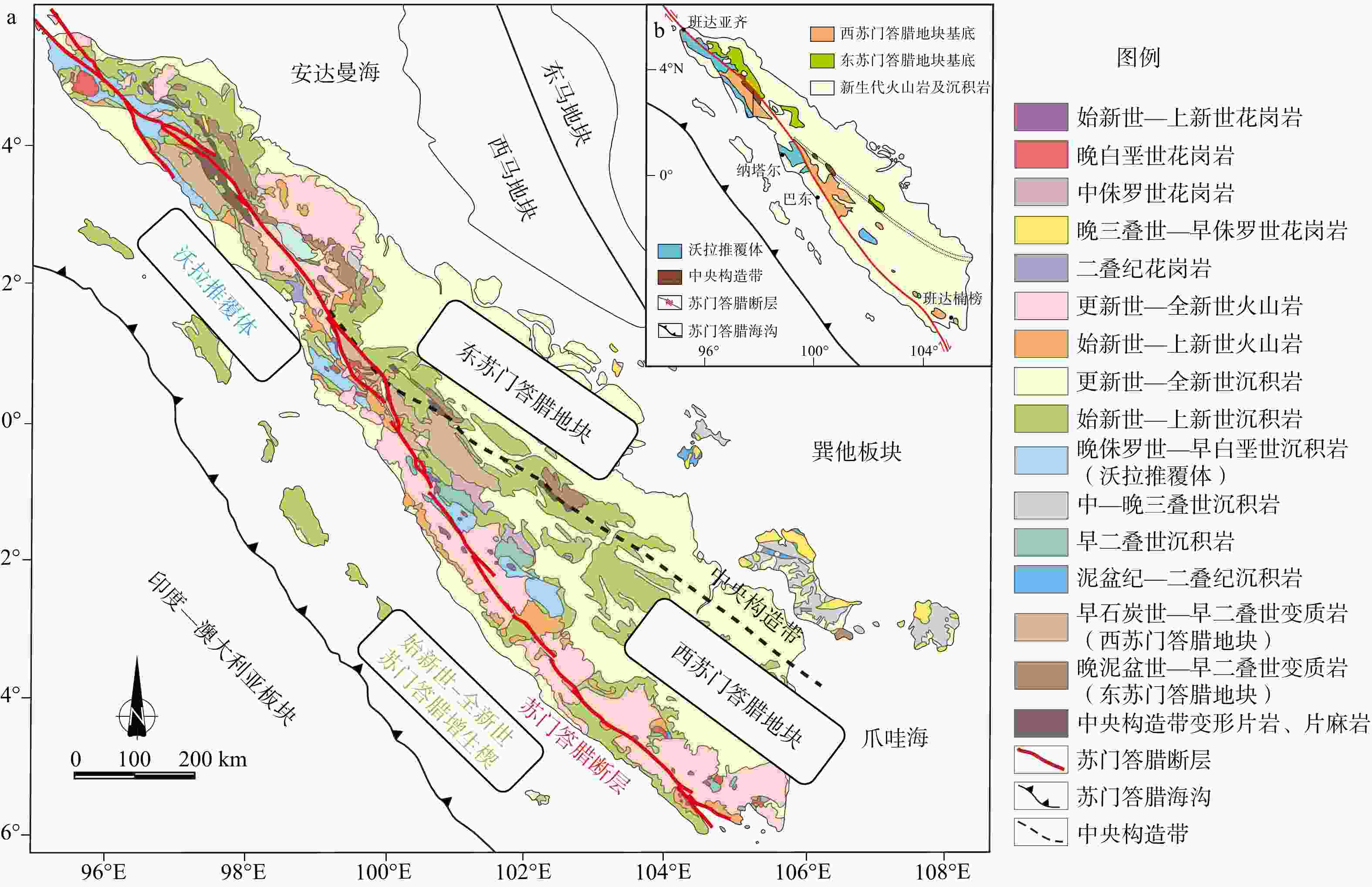
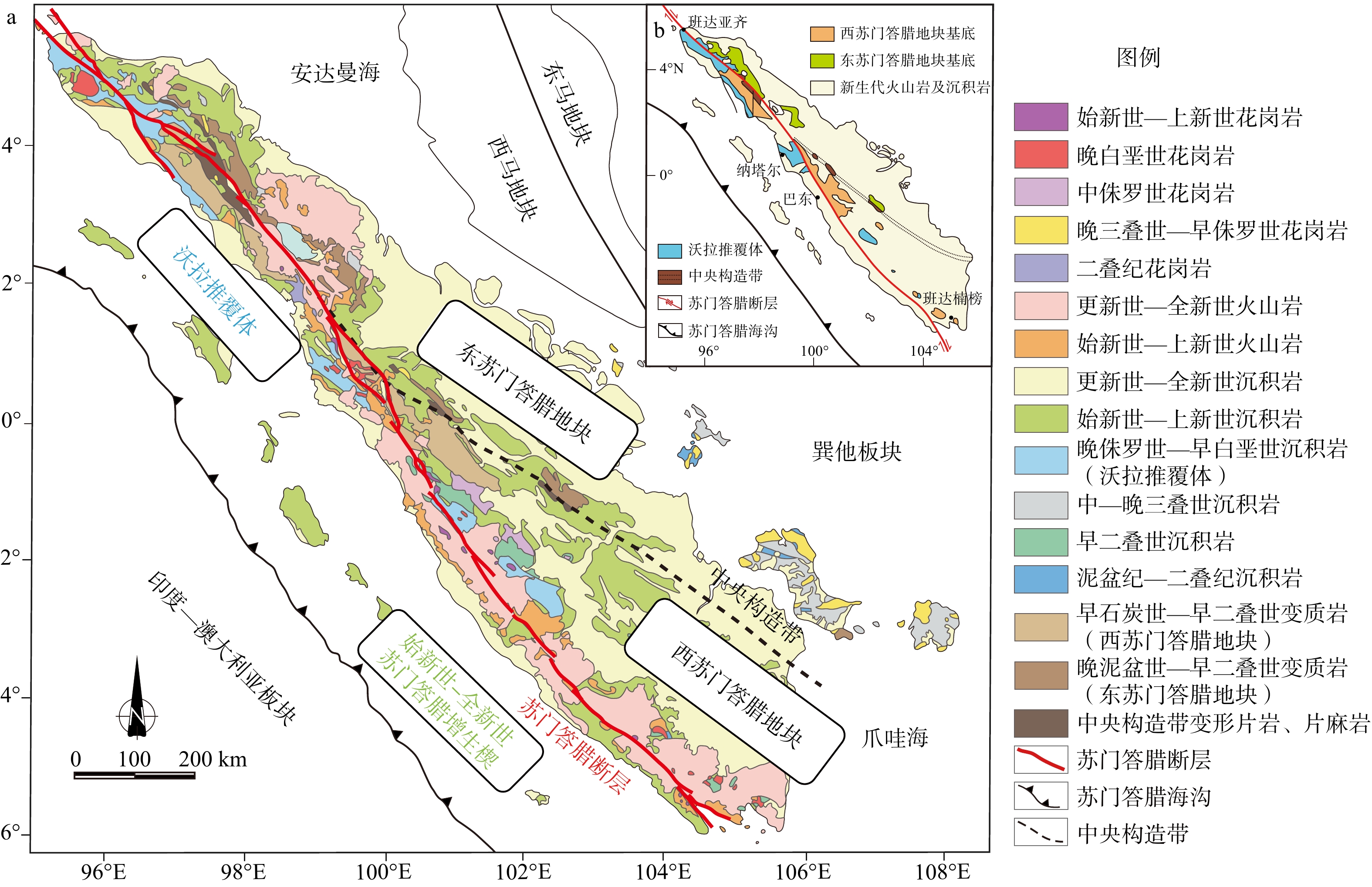
图 3 苏门答腊地质图
a—苏门答腊地质图(据Barber et al.,2005修改);b—苏门答腊地质单元简图(据Advocaat et al.,2018修改)
Figure 3. Geologic maps of Sumatra
(a) Geologic map of Sumatra (modified after Barber et al., 2005); (b) Simplified map of the geological units of Sumatra (modified after Advokaat et al., 2018)
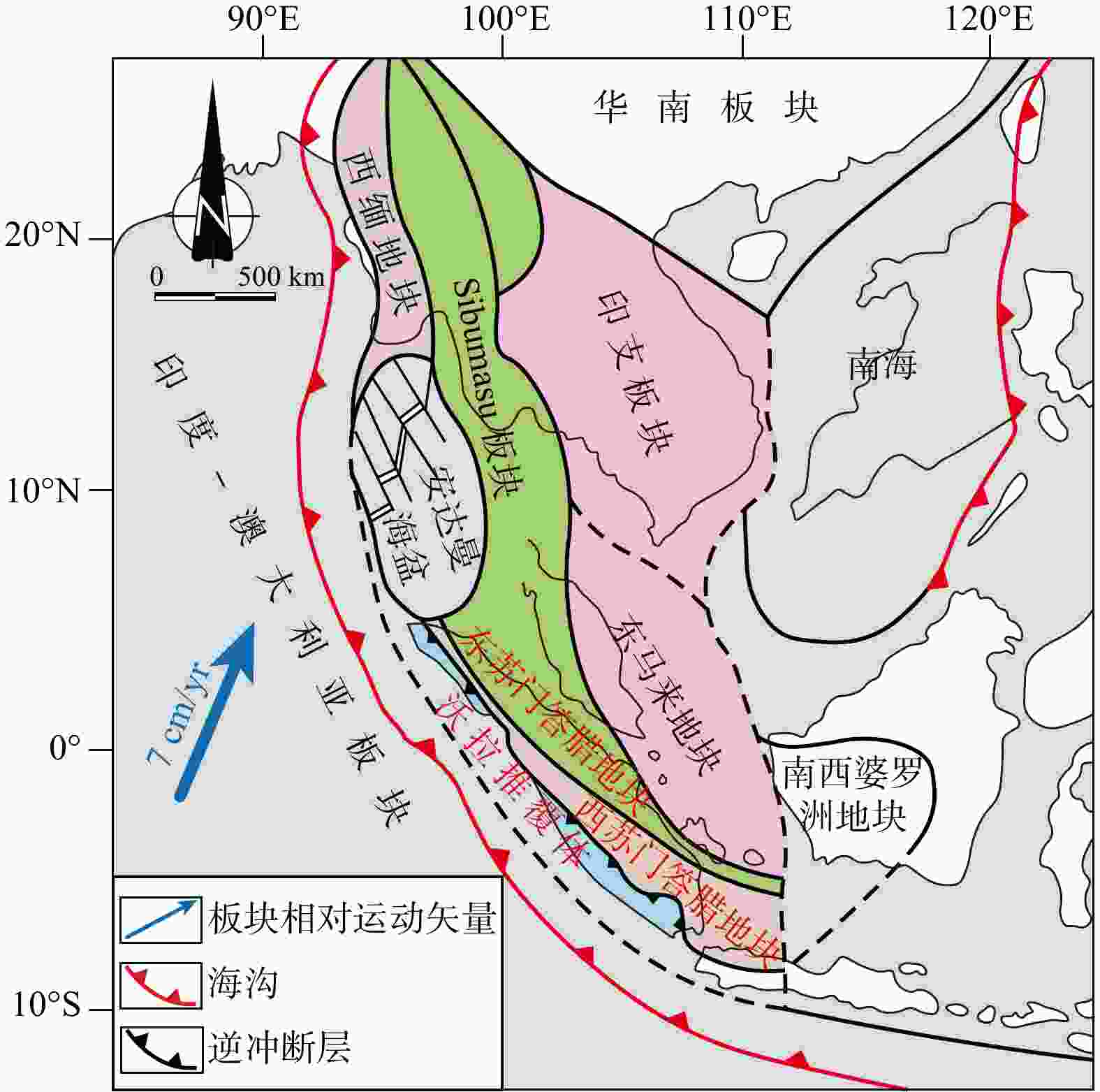
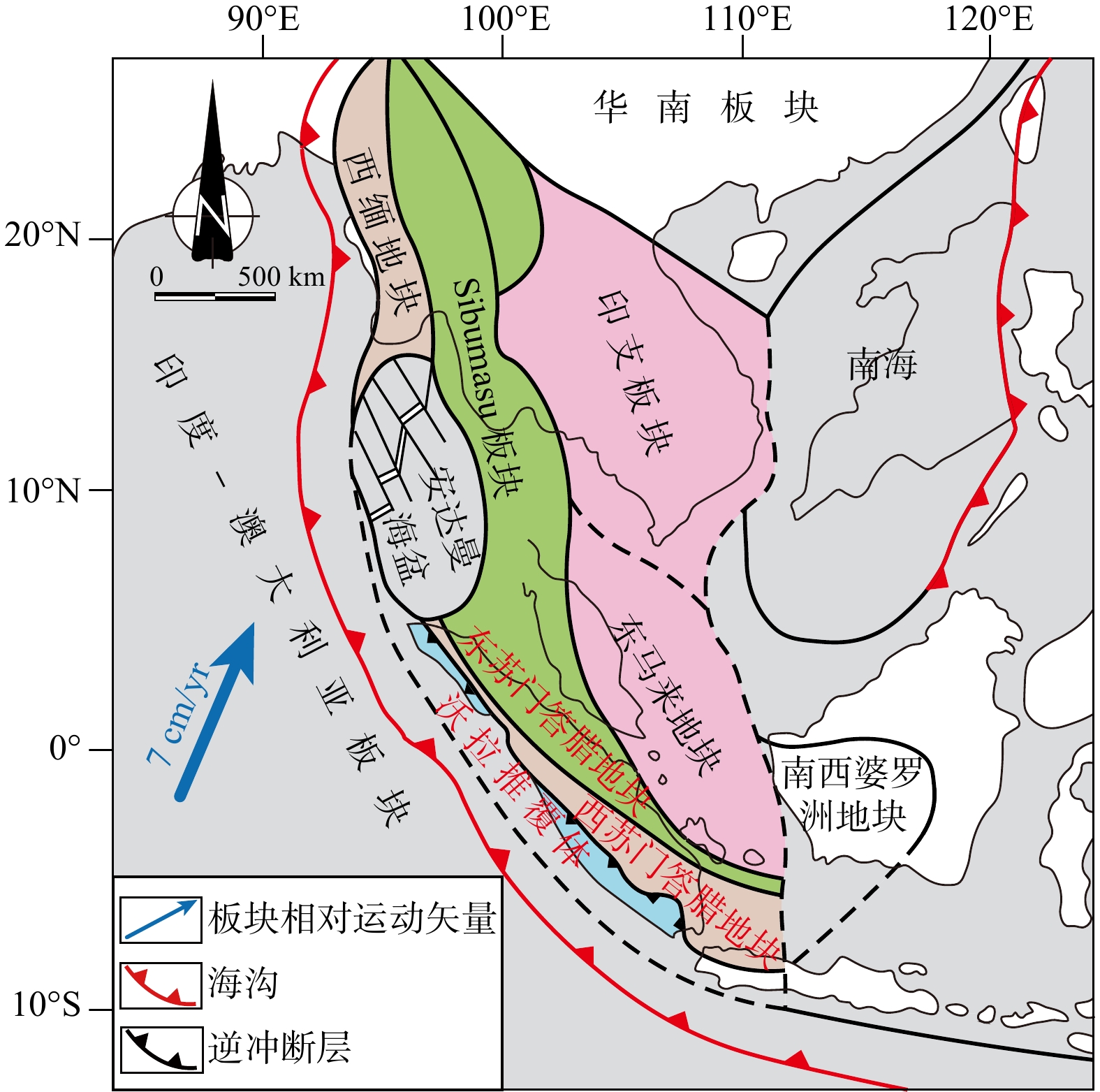
图 4 东南亚大地构造示意图(据Barber and Crow,2009修改)
Figure 4. Schematic diagram of the tectonics of Southeast Asia (modified after Barber and Crow, 2009)
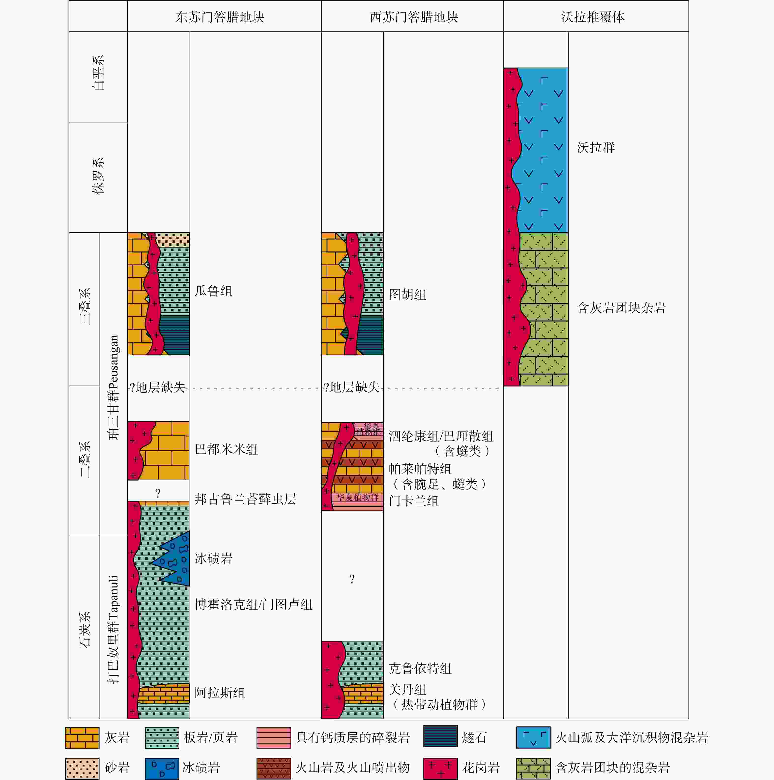
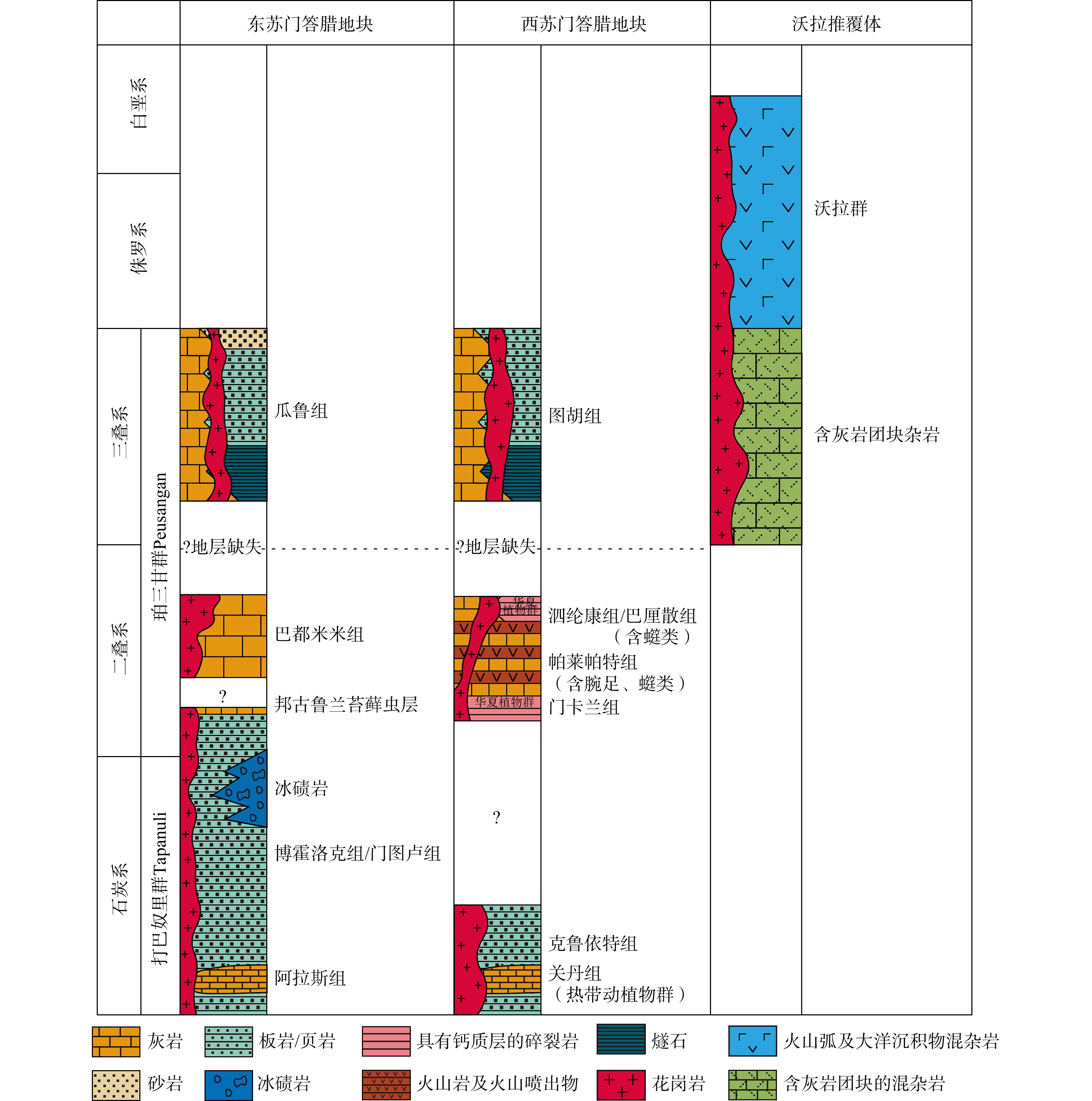
图 5 苏门答腊岛构造及地层单元(据Barber and Crow,2009;Qian et al.,2025;尚庆华等,2025修改)
Figure 5. Tectonic and stratigraphic units in Sumatra (modified after Barber and Crow, 2009; Qian et al., 2025; Shang et al., 2025)
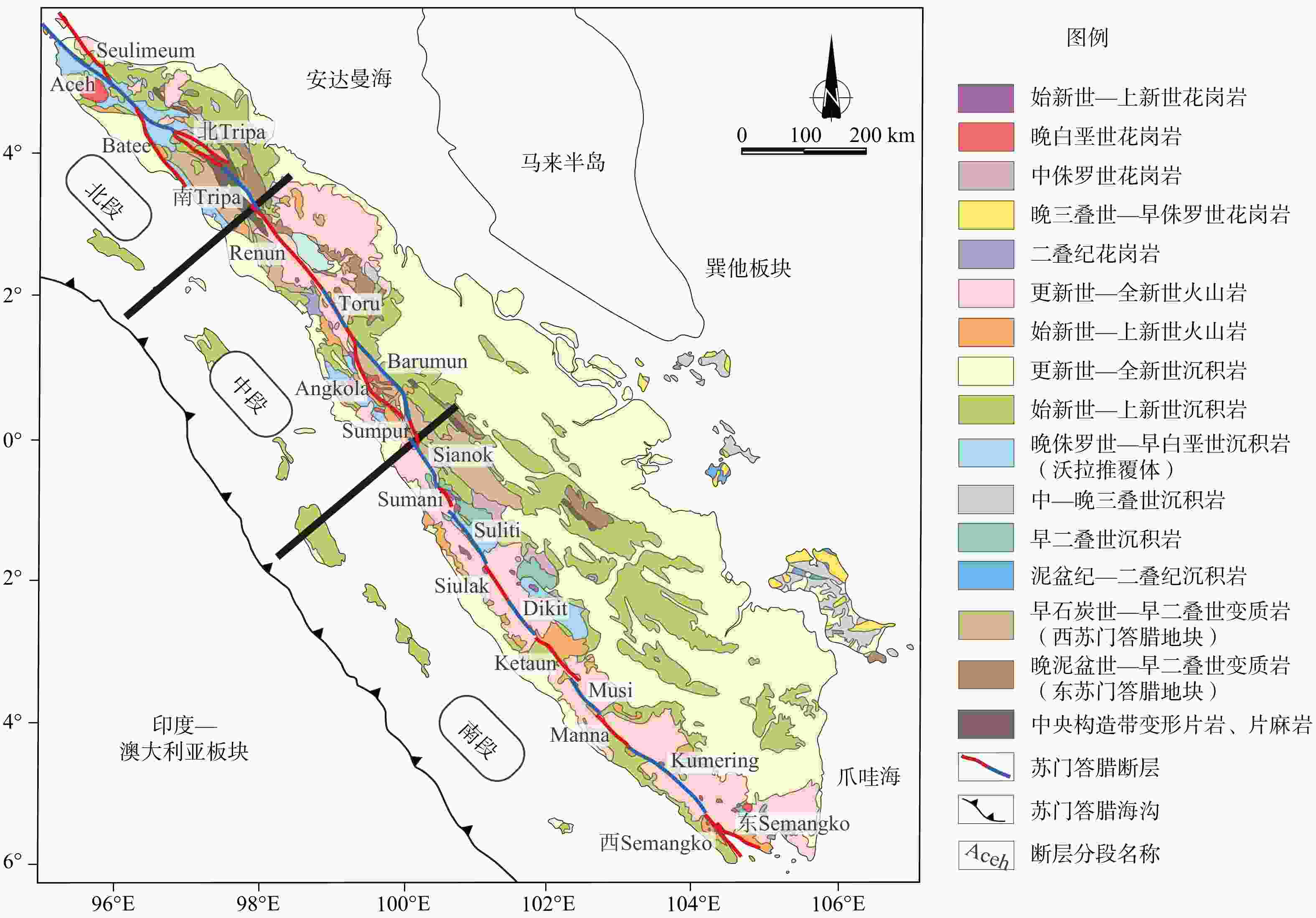
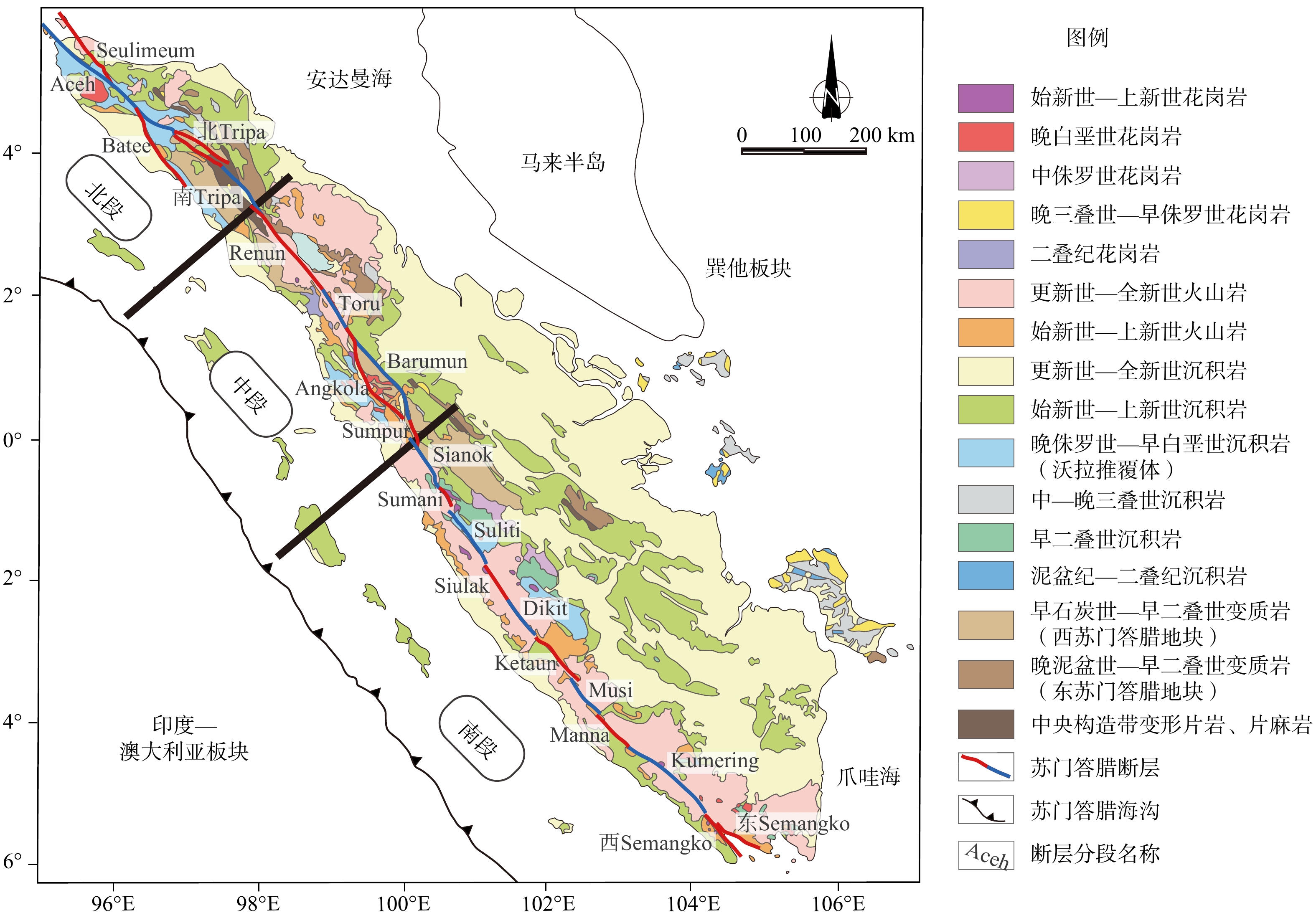
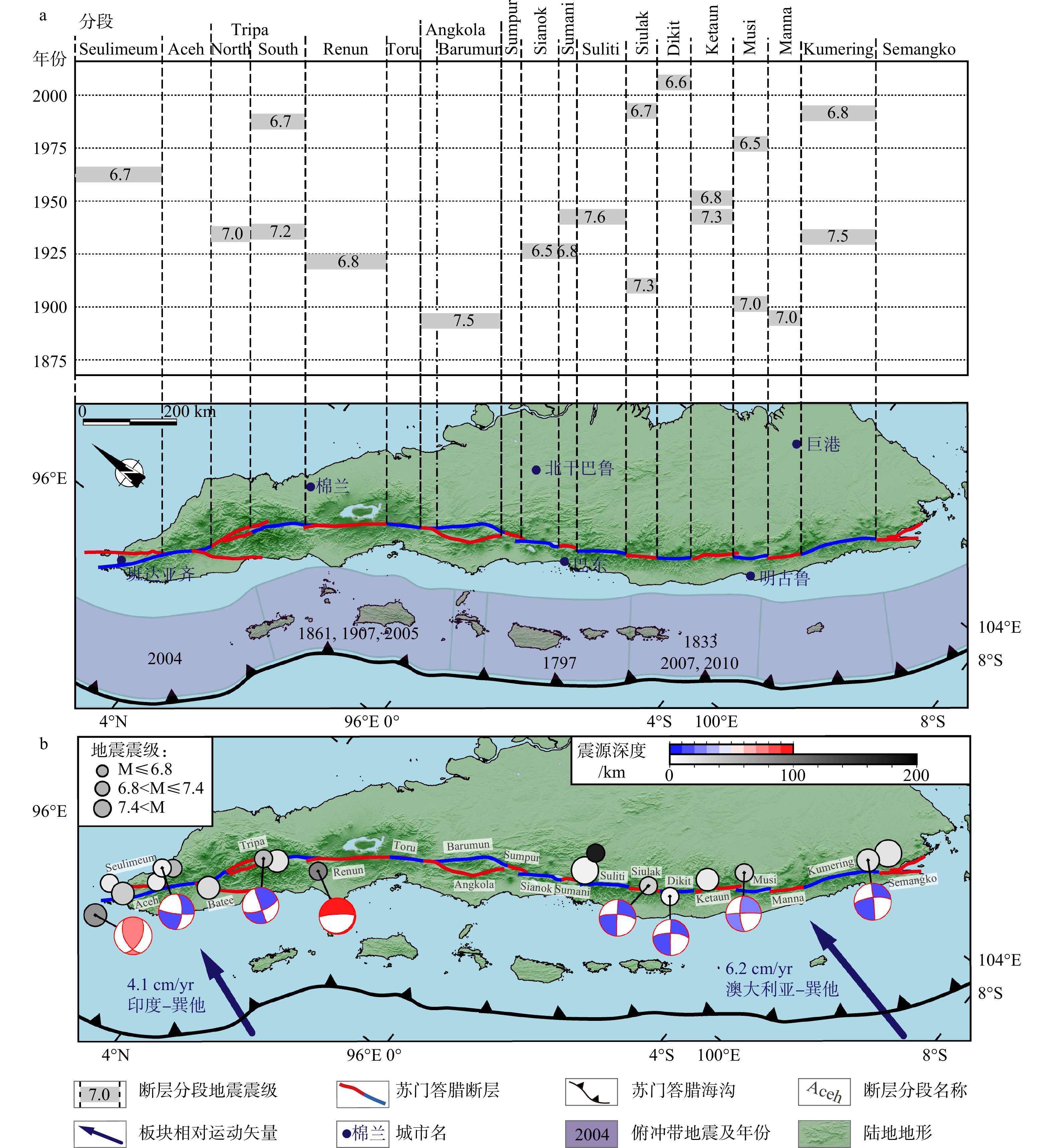
图 6 苏门答腊断层分段示意图
地质图据 Barber et al.,2005修改;断层分段数据引自Sieh和Natawidjaja(2000);分段特征详见2.2节
Figure 6. Schematic map of the Sumatran Fault segments
Geological map modified after Barber et al., 2005; fault segmentation data from Sieh and Natawidjaja (2000). Details of the fault segmentation characteristics are given in Section 2.2.
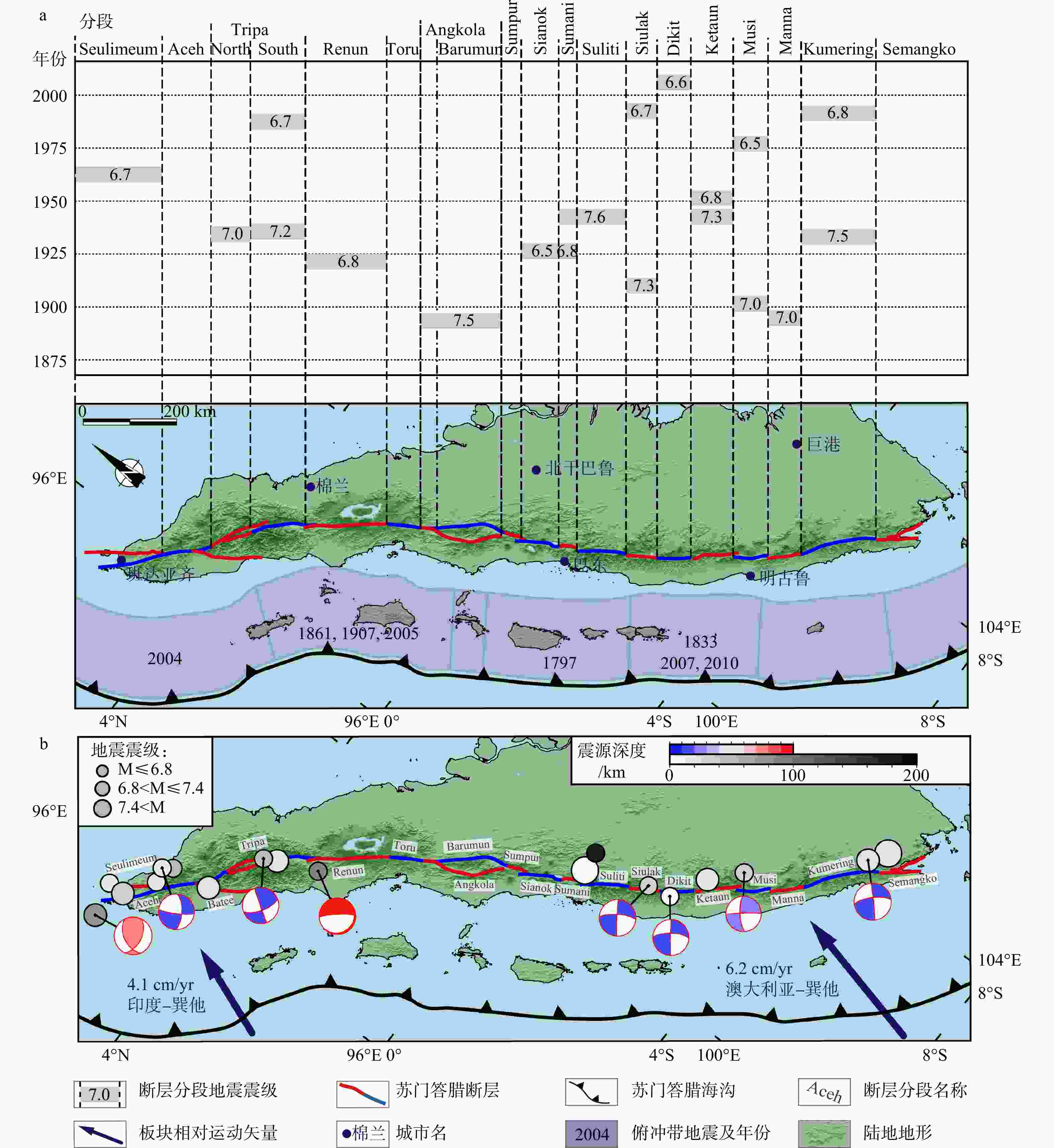
图 7 苏门答腊断层地震统计
a—苏门答腊断层分段地震活动统计(据Rafie et al.,2023修改);b—苏门答腊断层附近部分地震震源机制解(1900—2025年,M≥6.5);地震震中及震级数据来源:美国地质调查局官网(USGS,
https://earthquake.usgs.gov/earthquakes/ ),其中1976年及以后的地震震源机制解沙滩球数据来自全球矩心矩张量计划(Global CMT,https://www.globalcmt.org/ )Figure 7. Statistics of earthquakes along the Sumatran Fault
(a) Segmented seismicity statistics of the Sumatran Fault (modified after Rafie et al., 2023); (b) Focal mechanism solutions for selected earthquakes (M≥6.5) near the Sumatran Fault (1900~2025). Data Sources: Earthquake epicenter and magnitude data from the U.S. Geological Survey (USGS) [
https://earthquake.usgs.gov/earthquakes/ ]; Focal mechanism solutions (1976–present) from the Global Centroid-Moment-Tensor (CMT) Project [https://www.globalcmt.org/ ]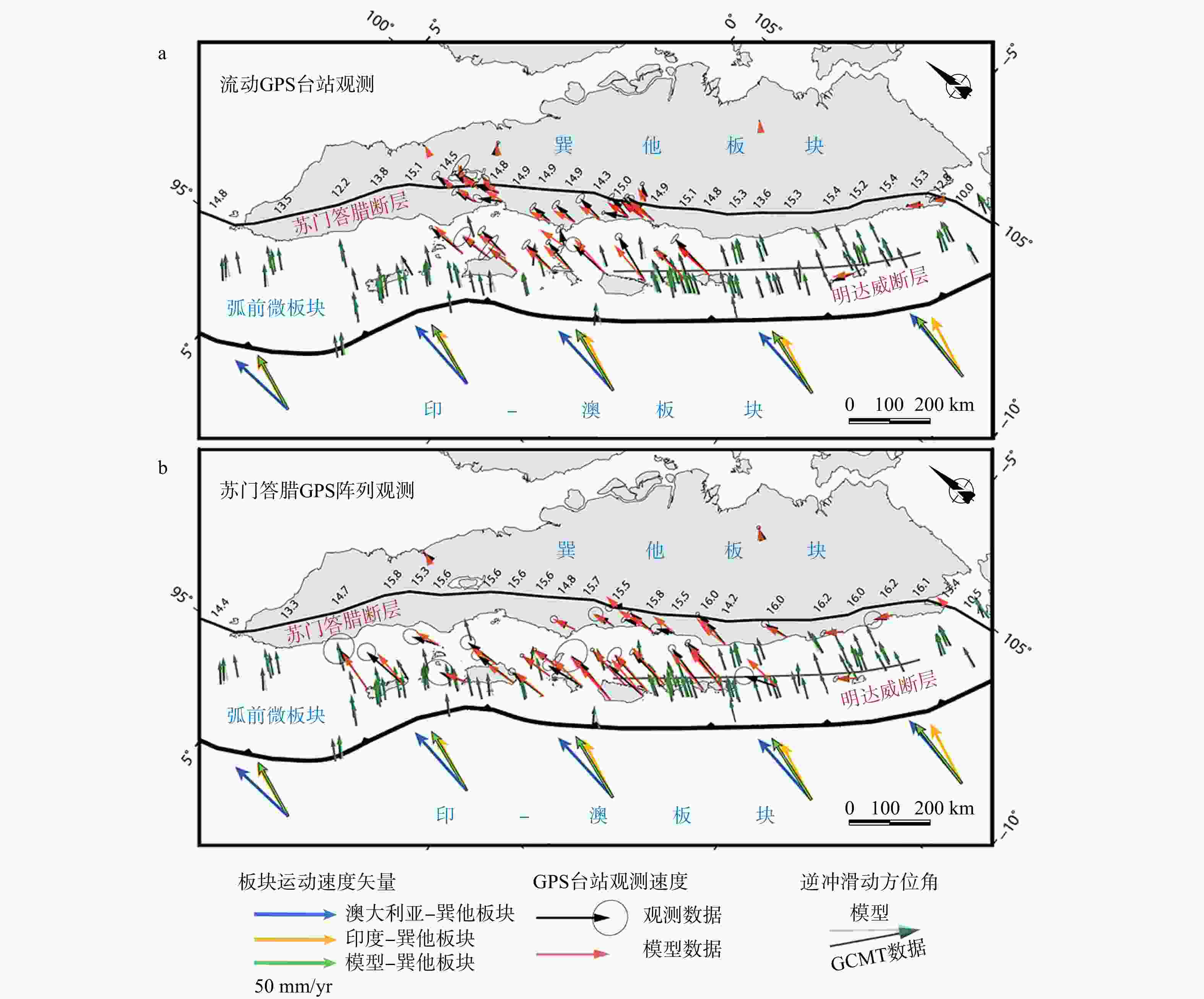
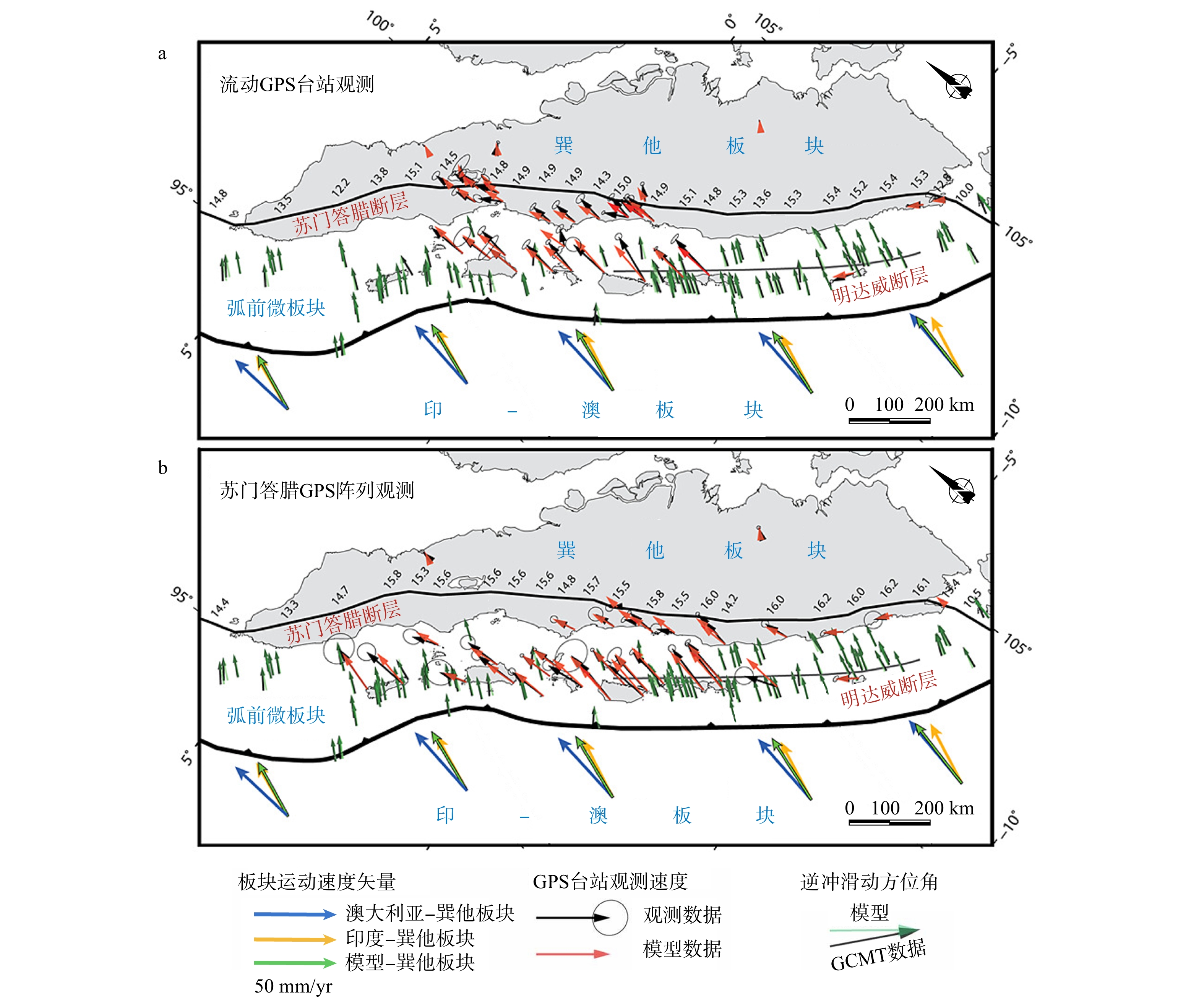
图 8 苏门答腊断层GPS测量走滑速率(据Bradley et al.,2017修改)
“模型”为Bradley et al.(2017)模型校正数据;弧前区域黑色箭头为全球质心矩张量计划(Global Centroid-Moment-Tensor Project,GCMT)测量大型逆冲断层滑动方位角,绿色箭头为模型校正逆冲滑动方位角;数字代表模型计算苏门答腊断层在该处滑移速率,mm/yr
Figure 8. GPS-measured slip rates along the Sumatran Fault (modified after Bradley et al., 2017)
“Model” represents corrected velocities from the model by Bradley et al., 2017. In the forearc region, black arrows indicate thrust slip azimuths derived from the Global Centroid-Moment-Tensor (CMT) Project, green arrows represent model-corrected thrust slip azimuths, and the numbers represent the model-calculated slip rates of the Sumatran Fault.
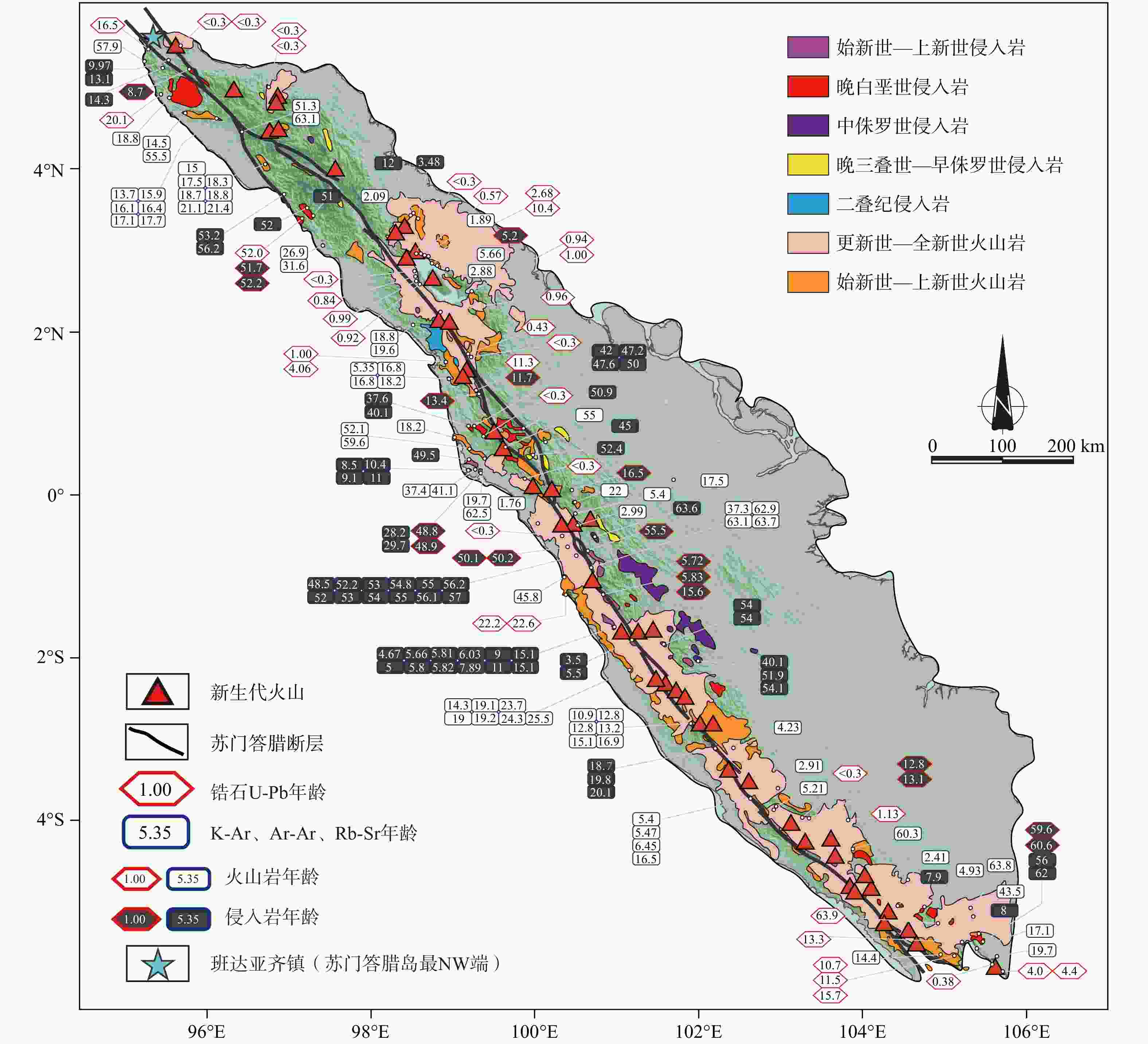
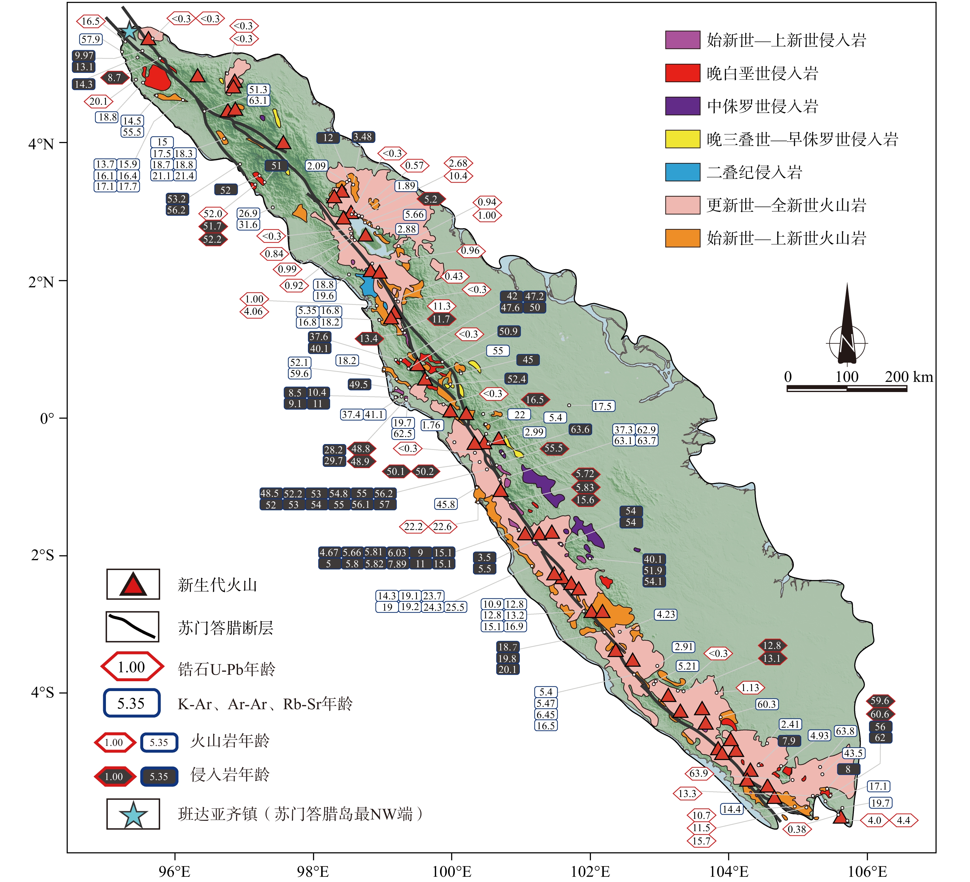
图 9 苏门答腊岛新生代岩浆岩及火山年龄分布(据Lai et al.,2023修改)
Figure 9. Ages of igneous and volcanic rocks on Sumatra Island (modified after Lai et al., 2023)
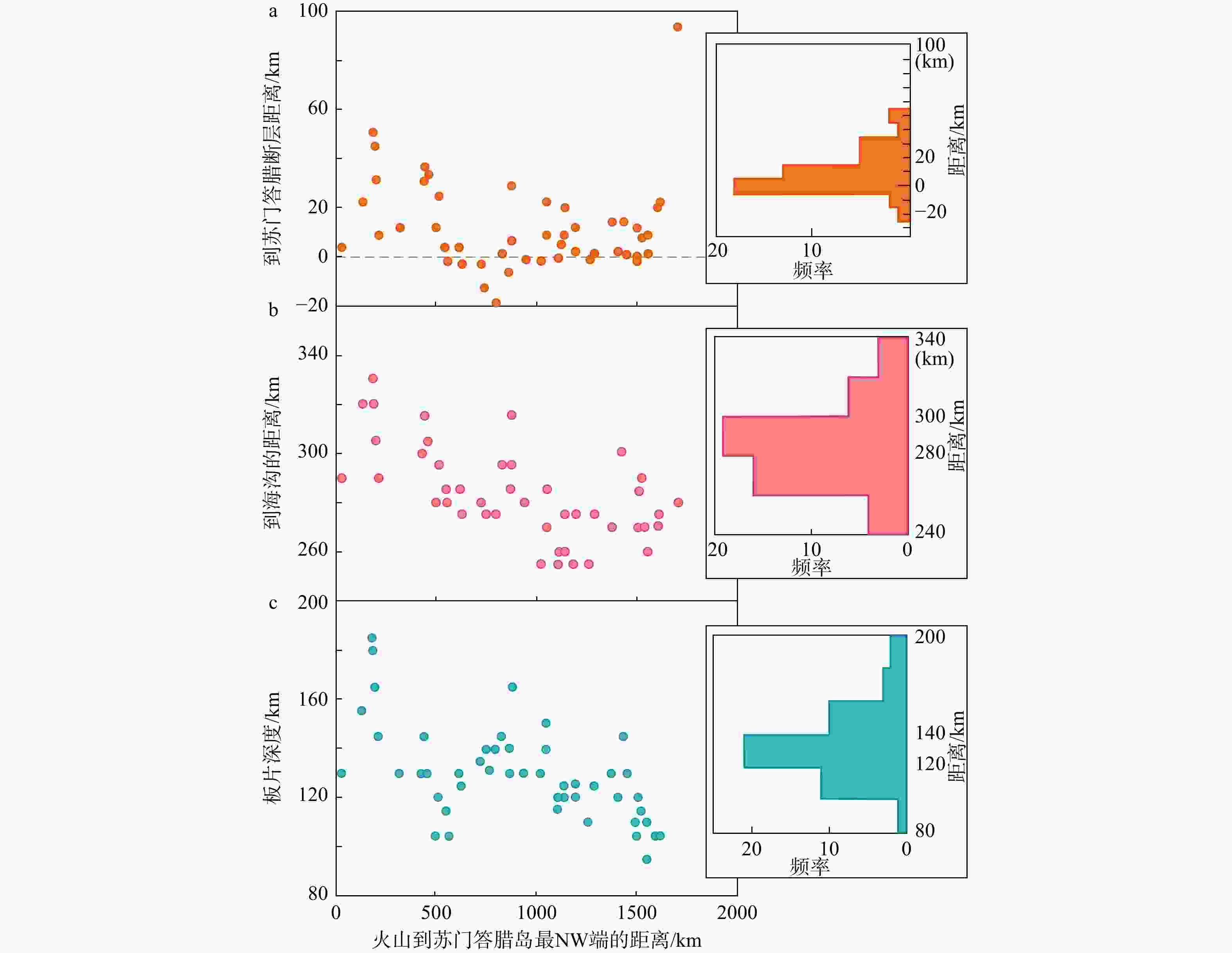
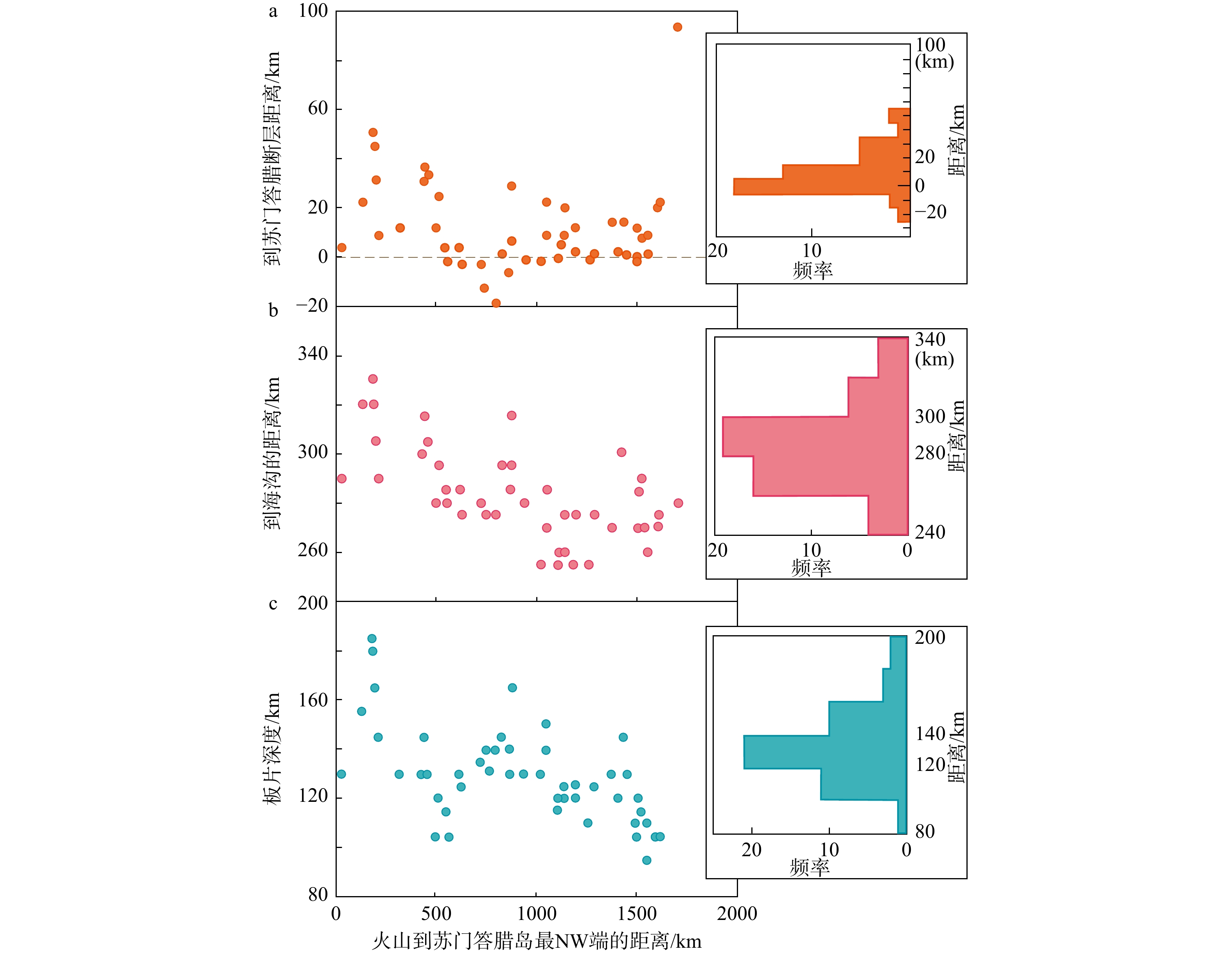
图 10 苏门答腊岛火山统计图(据Acocella et al.,2018修改)
图中横坐标测量零点位置见图9蓝色五角星位置a—苏门答腊岛火山−苏门答腊断层距离统计(正值表示火山在断层东侧,反之在西侧);b—苏门答腊岛火山−苏门答腊海沟距离统计;c—苏门答腊岛火山−俯冲板片深度距离统计
Figure 10. Distribution of volcanoeson Sumatra Island as a function of distance from the Sumatran Fault, the trench, and slab depth (modified after Acocella et al., 2018) (a) Distance from the Sumatran Fault (Positive values indicate volcanoes east of the fault, and negative values indicate west of the fault); (b) Distance from the trench; (c) Distance from the slab depth contour The measurement origin of the x-axis is marked by the blue five-pointed star in Fig. 9.
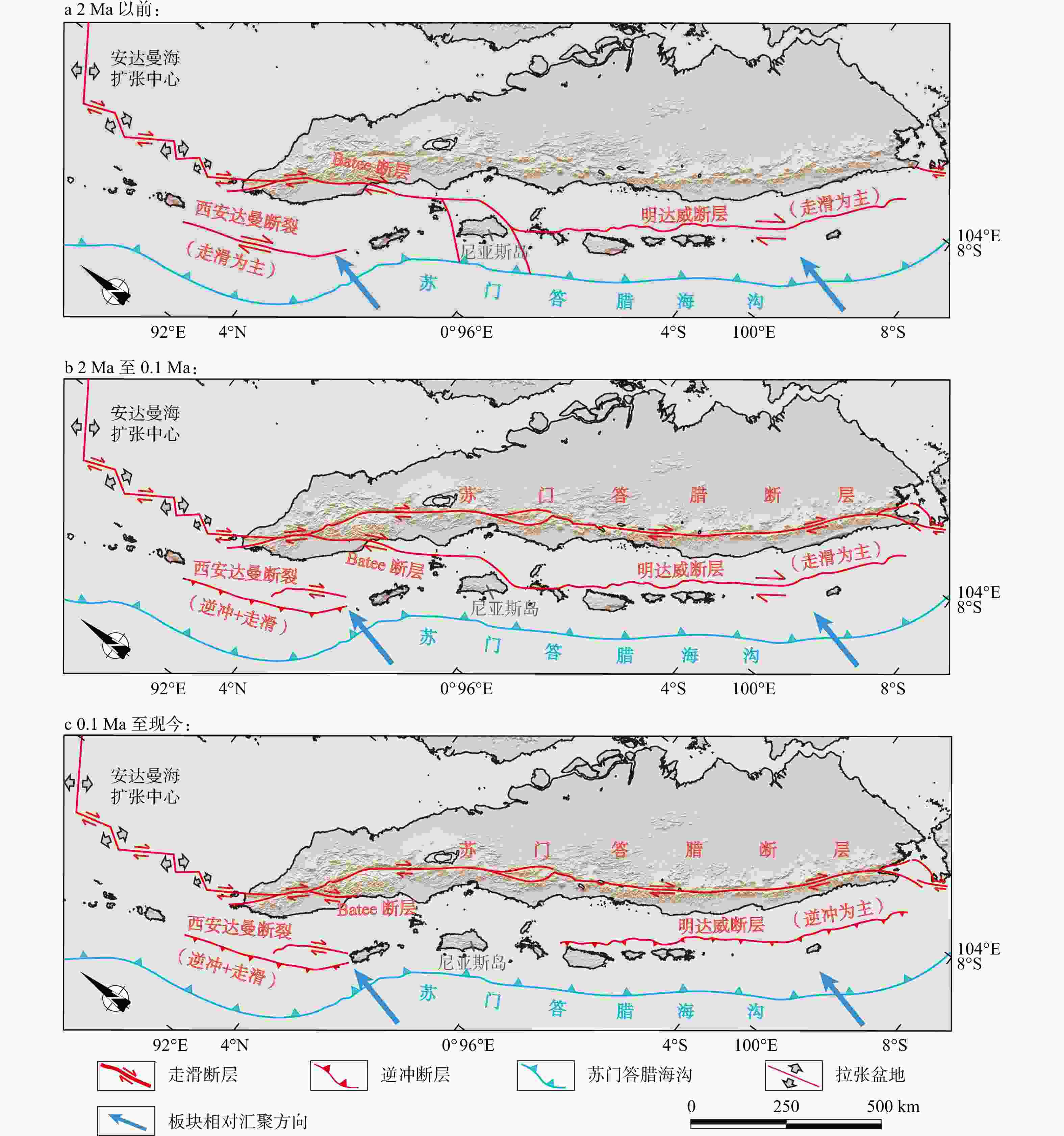
图 11 苏门答腊断层演化示意图(据Sieh and Natawidjaja,2000;Wang et al.,2023修改)
图中灰色区域为水域,其余区域为陆地a—2 Ma以前,苏门答腊北部Batee断层向北与安达曼海盆扩张脊的转换断层相连,向南延伸至尼亚斯岛附近与弧前的明达威断层,明达威断层开始活动,但以压扭活动为主;b—2~0.1 Ma,苏门答腊断层开始活动,其与明达威断层各自承担一部分水平走滑分量;c—0.1 Ma至现今,明达威断层走滑分量减少/停止,主要以逆冲变形为主(Singh et al.,2010),2°N以北的苏门答腊断层走滑速率增加,斜向汇聚的走滑分量主要通过苏门答腊断层协调
Figure 11. Schematic illustration of the Sumatran Fault evolution (modified after Sieh and Natawidjaja, 2000; Wang et al., 2023).
(a) Before 2 Ma (The Batee Fault in northern Sumatra connected northward to the transform fault of the Andaman Sea basin spreading ridge, and extended southward to link with the Mentawai Fault in the forearc near Nias Island. The Mentawai Fault initiated during this stage, with transpressional motion dominating.); (b) 2–0.1 Ma (The Sumatran Fault initiated, with the horizontal strike-slip component partitioned between the Sumatran Fault and the Mentawai Fault.); (c) 0.1 Ma to present (Strike-slip motion along the Mentawai Fault decreased or ceased, transitioning to dominant thrust deformation; Singh et al., 2010. Concurrently, the strike-slip rate of the Sumatran Fault north of 2° N latitude has increased. At this stage, the trench-parallel slip component of oblique convergence is primarily accommodated by the Sumatran Fault.) Grey shaded areas indicate water bodies, the remaining areas denote land.
表 1 苏门答腊断层各分段特征及次级断层特征
Table 1. Features of segments of the Sumatran Fault and secondary faults
分段 周边次级断层 纬度 长度/
km走向/° 南端特点/分段特征 最大历史地震活动 到变形前锋
带距离/km俯冲界面
深度/km数据来源 Seulimeum段 5.9°~5.0°N 148 148 张扭弯折及拉张阶区,4 km
宽;深度达16 km;与Seulawah
火山联系较密1964(MW=6.96) — 125~140 Sieh and Natawidjaja,2000;Muksin et al.,2019 Aceh段 5.4°~4.4°N 200 135 挤压阶区,3 km宽;地表活动弱但深部活跃 无震蠕滑 323 105~130 Sieh and Natawidjaja,2000;Ito et al.,2012;Natawidjaja,2018b;Tong et al.,2018 Pidie/Bireun/
Lhok-Sumawe
断层5.29°N附近 — 145 右旋走滑,分担主断层东部应变 2016(Pidie, MW=
6.5), 1942(Bireun, M=6.8)— — Muzli et al.,2018; Natawidjaja,2018b Panteraja断层 5.235°N附近 20 42 左旋走滑(倾角63°),深度8~
28 km;地表无破裂,但余震呈线性分布— — — Muzli et al.,2018 Batee段 4.6°~3.5°N 138 150 向南延伸至增生楔 — — — Natawidjaja,2018b;Muksin et al.,2019, 2023 Lokop断层 4.6°N附近 — 170 右旋走滑;分Lokop段(北)和Kutacane段(南) — — — Muksin et al.,2023 Langsa断层 近Langsa市 — 145 逆冲断层(倾向北,倾角26°),伴生褶皱-逆冲带;由苏门答腊–Mergui微板块挤压形成 2018(MW=5.3) — — Muksin et al.,2023 北Tripa段 4.4°~4.0°N 83 114 地震与地形显示其呈两条平行线分布 1935(MW=7.0) 295 125~150 Sieh and Natawidjaja,2000;Burton and Hall,2014;Muksin et al.,2023 南Tripa段 4.0°~3.2°N 122 144 拉张阶区,9 km宽 1936(MW=7.06), 1990(MW=6.7) Renun段 3.5°~2.0°N 220 140 拉张阶区,3 km宽 1936(MW=7.06) 286 100~125 Sieh and Natawidjaja,2000 Alas断层 3.4°~2.8°N — 165 南Tripa与Renun段西侧,浅源
走滑— — — Muksin et al.,2023 Toru段 2.0°~1.2°N 95 152 压扭弯折 1984(MS=6.4), 1987(MS=6.6) 294 125~155 Sieh and Natawidjaja,2000 Angkola段 1.8°~0.3°N 160 145 几何结构复杂区 1892(MS=7.7) 290 135~155 Sieh and Natawidjaja,2000 Barumun段 1.2°~0.3°N 125 144 张扭弯折区,23 km宽 位于应力影中 294 125~170 Sieh and Natawidjaja,2000 Sumpur段 0.3°~0°N 35 163 拉张阶区,12 km宽 — 308 165~175 Sieh and Natawidjaja,2000 Sianok段 0.1°~0.7°S 90 149 拉张阶区,4.5 km宽 1926(MW=6.58) 302 135~145 Sieh and Natawidjaja,2000 Sumani段 0.5°~1.0°S 60 142 拉张阶区,4.5 km宽 1943(MW=7.73),
1926(MS=6.8)293 130 Sieh and Natawidjaja,2000 Suliti段 1.0°~1.75°S 95 147 拉张阶区,4.5 km宽 1943(MW=7.73) 273 130 Sieh and Natawidjaja,2000 Siulak段 1.7°~2.25°S 70 148 拉张阶区,11 km宽 1909(M=7.3), 1995(MW=6.8) 266 120~130 Sieh and Natawidjaja,2000 Dikit段 2.3°~2.75°S 60 141 断层几何结构复杂区,不连续 2009(MW=6.6) — — Sieh and Natawidjaja,2000 Ketaun段 2.75°~3.35°S 85 141 拉张阶区,5~18.5 km宽 1943(MW=7.38), 1952(MS=6.8) 271 110~125 Sieh and Natawidjaja,2000 Musi段 3.25°~3.65°S 81 145 拉张阶区,5.6 km宽 1979(MS=6.6) 260 115 Sieh and Natawidjaja,2000 Manna段 3.8°~4.35°S 85 135 压扭弯折区,挠度17° 1893(M=7.0) 275 120 Sieh and Natawidjaja,2000 Kumering段 4.35°~5.3°S 162 131 拉张阶区,6 km宽 1933(MW=7.52), 1994(MW=6.9) 300 100~120 Sieh and Natawidjaja,2000 西Semangko段 5.25°~6.5°S 95 140 形成西Semangko海沟(水深1800 m);向南与海沟相连呈三角形开口 — 220~270 50~100 Sieh and Natawidjaja,2000 东Semangko段 5.25°~5.9°S 116.4 125 形成东Semangko海沟(水深
800 m)— Ujung Kulon
断层6.3°~7.5°S — 140 右旋走滑,连接Semangko海沟;构成SFZ南延传递断层 — — — Natawidjaja,2018b 注:分段“到变形前锋带距离”和“俯冲界面深度”数据来源:Sieh and Natawidjaja,2000;“最大历史地震活动”数据来源:Hurukawa et al.,2014和Rafie et al.,2023。MW为矩震级,MS为面波震级,M为未特别指明类型的震级。“Barumun段位于应力影中”指其被邻近的Angkola段1892年地震影响;1943年Sumani段和Suliti段地震为多段破裂,两段均发生完全破裂  下载: 导出CSV
表 2 苏门答腊断层地质滑移速率表
Table 2. Geological slip rates of the Sumatran Fault
测量地点坐标 滑移速率 mm/yr 数据来源文献 测量方法 北苏门答腊 Aceh 省
(约5°N,95°E)38±4 Bennett et al.,1981;
Genrich et al.,2000无实际测量 北苏门答腊 Toba
(2.3°N,99°E)23±3 Detourbet et al,1993 SPOT卫星影像解译河流错断 北苏门答腊 Toba
(2.3°N,99°E)27~28 Sieh et al.,1991,1994 小尺度地形图解译河流错断 中苏门答腊 Toru段
(1.6°N,99°E)7~14 Hickman et al.,2004 玄武岩穹丘错断(40Ar/39Ar定年 270±3 ka) 南苏门答腊 Musi段
(3.5°S,103°E)10 Sieh et al.,1994 火山熔岩流的错断 南苏门答腊 Kumering段
(约5°S,105°E)5.5±1.9 Bellier et al.,1999 SPOT影像解译构造线+40K/40Ar定年(0.55±0.15 Ma) 北苏门答腊 Toba
(2.3°N,99°E)14.1±0.5 Bradley et al.,2017 高分辨率卫星影像(Quick Bird/World View-2)精确解译14条河流偏移+40Ar/39Ar定年(73.88±0.64 ka) 中苏门答腊 Maninjau
(0.2°S,100.3°E)14.5±0.5 Bradley et al.,2017 高分辨率影像解译8条河流偏移+14C/火山玻璃裂变径迹定年(51.1±0.9 ka)
下载: 导出CSV
-
[1] ACOCELLA V, BELLIER O, SANDRI L, et al., 2018. Weak Tectono-Magmatic Relationships along an Obliquely Convergent Plate Boundary: Sumatra, Indonesia[J]. Frontiers in Earth Science, 6: 3. doi: 10.3389/feart.2018.00003 [2] ADVOKAAT E L, BONGERS M L M, RUDYAWAN A, et al., 2018. Early Cretaceous origin of the Woyla Arc (Sumatra, Indonesia) on the Australian Plate[J]. Earth and Planetary Science Letters, 498: 348-361. doi: 10.1016/j.epsl.2018.07.001 [3] ATWATER T, 1970. Implications of plate tectonics for the Cenozoic tectonic evolution of western North America[J]. GSA Bulletin, 82(12): 3513-3536. doi: 10.1130/0016-7606(1970)81[3513:ioptft]2.0.co;2 [4] AYDIN A, NUR A. 1982. Evolution of pull-apart basins and their scale independence[J]. Tectonics, 1(1): 91-105. [5] AYDIN A, SCHULTZ R A, CAMPAGNA D, 1990. Fault-normal dilatation in pull-apart basins: implications for relationship between strike-slip faults and volcanic activity[J]. Ann. Tectonicae Spec. Issue, 4(2): 45-52. [6] BARBER A J, 2000. The origin of the Woyla Terranes in Sumatra and the Late Mesozoic evolution of the Sundaland margin[J]. Journal of Asian Earth Sciences, 18(5): 713-738. doi: 10.1016/s1367-9120(00)00024-9 [7] BARBER A J, CROW M J, MILSOM J S, 2005. Sumatra: Geology, resources and tectonic evolution[M]. Geological Society, London, Memoirs, 31: 234-259. [8] BARBER A J, CROW M J, 2009. The structure of Sumatra and its implications for the tectonic assembly of Southeast Asia and the destruction of Paleotethys[J]. Island Arc, 18(1): 3-20. doi: 10.1111/j.1440-1738.2008.00631.x [9] BECK M E JR, 1983. On the mechanism of tectonic transport in zones of oblique subduction[J]. Tectonophysics, 93: 1-11. doi: 10.1016/0040-1951(83)90230-5 [10] BELLIER O, SÉBRIER M, 1994. Relationship between tectonism and volcanism along the Great Sumatran fault zone deduced by SPOT image analyses[J]. Tectonophysics, 233(3-4): 215-231. doi: 10.1016/0040-1951(94)90242-9 [11] BELLIER O, SÉBRIER M, 1995. Is the slip rate variation on the Great Sumatran Fault accommodated by fore-arc stretching?[J]. Geophysical Research Letters, 22(15): 1969-1972. doi: 10.1029/95GL01793 [12] BELLIER O, SÉBRIER M, PRAMUMIJOYO S, et al., 1997. Paleoseismicity and seismic hazard along the Great Sumatran fault (Indonesia)[J]. Journal of Geodynamics, 24(1-4): 169-183. doi: 10.1016/S0264-3707(96)00051-8 [13] BELLIER O, BELLON H, SÉBRIER M, et al., 1999. K-Ar age of the Ranau tuffs: implications for the Ranau caldera emplacement and slip-partitioning in Sumatra (Indonesia)[J]. Tectonophysics, 312: 347-359. doi: 10.1016/S0040-1951(99)00198-5 [14] BENNETT J D, et al., 1981. Geologic Map of Banda Aceh Quadrangle, North Sumatra, 1: 250000[R]. Geol. Res. and Dev. Cent, Bandung, Indonesia. [15] BERLAGE H JR, 1934. De aardbeving in zuid Sumatra van 25 Juni 1933: Waarnemingen in het epicentrale gebied[R]. Natuurwetenschappelijk Tijdschrift voor Nederlandsch-Indië, 94: 15-36. [16] BRADLEY K, FENG L, HILL E M, et al., 2017. Implications of the diffuse deformations of the Indian Ocean lithosphere for slip partitioning of oblique plate convergence in Sumatra[J]. Journal of Geophysical Research: Solid Earth, 122(1): 572-591. doi: 10.1002/2016JB013549 [17] BURTON P W, HALL T R, 2014. Segmentation of the Sumatran fault[J]. Geophysical Research Letters, 41: 4149-4158. doi: 10.1002/2014GL060242 [18] CAMERON N R, CLARKE M C G, ALDISS D T, et al., 1980. The geological evolution of northern Sumatra[C]. Proceedings of the Indonesian Petroleum Association, Annual Convention, Jakarta 1980(9): 149-87. [19] CAMERON N, et al., 1983. Geology of the Takengon quadrangle, Sumatra[R]. Report Geol. Res. And Dev. Cent., Bandung, Indonesia. [20] CHEN J L, WILSON C R, TAPLEY B D, et al., 2007. GRACE detects coseismic and postseismic deformation from the Sumatra-Andaman earthquake[J]. Geophysical Research Letters, 34(13): L13302. doi: 10.1029/2007gl030356 [21] COOKE M L, DAIR L C, 2011. Simulating the recent evolution of the southern big bend of the San Andreas fault, Southern California[J]. Geophys. Res., 116, B04405. [22] CURRAY J R, MOORE D G, LAWVER L A, et al., 1979. Tectonics of the Andaman Sea and Burma: Convergent margins[C]//WATKINS J S, MONTADERT L, DICKENSON P W, eds. Geological and Geophysical Investigations of Continental Margins. American Association of Petroleum Geologists Memoir, 29: 189-198. [23] CURRAY J R, 2005. Tectonics of the Andaman Sea region[J]. Journal of Asian Earth Sciences, 25(1): 187-232. doi: 10.1016/j.jseaes.2004.09.001 [24] DETOURBET C, BELLIER O, SÉBRIER M, 1993. La caldera volcanique de Toba et filesysteme de faille de Sumatra (Indonesia) vue par SPOT[J]. C. R. Acad. Sci., Ser. II, 316: 1439-1445. [25] DIAMENT M, HARJONO H, KARTA K, et al., 1992. Mentawai fault zone off Sumatra: A new key to the geodynamics of western Indonesia[J]. Geology, 20(3): 259-262. doi: 10.1130/0091-7613(1992)020<0259:mfzosa>2.3.co;2 [26] DICKINSON W R, SNYDER W S, 1979. Geometry of triple junctions related to San Andreas transform[J]. Journal of Geophysical Research, 84(B2): 561-572. doi: 10.1029/JB084iB02p00561 [27] DING W, ZHU R, WAN B, et al., 2023. Geodynamic processes of the southeastern Neo-Tethys Ocean and the formation mechanism of the curved subduction system in Southeast Asia[J]. Science China Earth Sciences, 66(4): 703-717. (in Chinese with English abstract) doi: 10.1007/s11430-022-1071-4 [28] FITCH T J, 1972. Plate convergence, transcurrent faults, and internal deformation adjacent to Southeast Asia and the western Pacific[J]. Journal of Geophysical Research, 77(23): 4432-4460. doi: 10.1029/JB077i023p04432 [29] FRISCH W, MESCHEDE M, BLAKEY R C, 2011. Plate Tectonics: Continental Drift and Mountain Building[M]. Berlin Herdelburg: Springer-Verlag. 212 [30] FURLONG K P, 1984. Lithospheric behavior with triple junction migration: An example based on the Mendocino triple junction[J]. Physics of the Earth and Planetary Interiors, 36(3-4): 213-223. doi: 10.1016/0031-9201(84)90047-5 [31] GENRICH J F, BOCK Y, MCCAFFREY R, et al., 2000. Distribution of slip at the northern Sumatran fault system[J]. Journal of Geophysical Research: Solid Earth, 105(B12): 28327-28341. doi: 10.1029/2000JB900158 [32] HALL R, 2012. Late Jurassic–Cenozoic reconstructions of the Indonesian region and the Indian Ocean[J]. Tectonophysics, 570–571: 1–41. [33] HAMILTON W, 1979. Tectonics of the Indonesian Region[R]. U. S. Geological Survey Professional Paper 1078: 345 p. [34] HICKMAN R G, DOBSON P F, VAN GERVEN M, et al., 2004. Tectonic and stratigraphic evolution of the Sarulla graben geothermal area, North Sumatra, Indonesia[J]. Journal of Asian Earth Sciences, 23(3): 435-448. doi: 10.1016/S1367-9120(03)00155-X [35] HUBERT-FERRARI A, KING G, VAN DER WOERD J, et al., 2010. Long-term evolution of the North Anatolian Fault: New constraints from its eastern termination[J]. Geological Society, London, Special Publications, 311(1): 133-154. doi: 10.1144/sp311.5 [36] HUCHON P, Le PICHON X, 1984. Sunda Strait and central Sumatra fault[J]. Geology, 12(11): 668-672. doi: 10.1130/0091-7613(1984)12<668:ssacsf>2.0.co;2 [37] HURUKAWA N, WULANDARI B R, KASAHARA M, 2014. Earthquake history of the Sumatran fault, Indonesia, since 1892, derived from relocation of large earthquakes[J]. Bulletin of the Seismological Society of America, 104(4): 1750-1762. doi: 10.1785/0120130201 [38] HUTCHISON C S, 1994. Gondwana and Cathaysian blocks, Palaeotethys sutures and Cenozoic tectonics in Southeast Asia[M]. Oxford University Press: 388-405. [39] IRSYAM M, CUMMINS P R, ASRURIFAK M, et al., 2020. Development of the 2017 national seismic hazard maps of Indonesia[J]. Earthquake Spectra. https://doi.org/10.1177/8755293020951206. [40] ITO T, GUNAWAN E, KIMATA F, et al., 2012. Isolating along-strike variations in the depth extent of shallow creep and fault locking on the northern Great Sumatran Fault[J]. Journal of Geophysical Research: Solid Earth, 117(B6): B06409. doi: 10.1029/2011jb008940 [41] JARRARD R D, 1986. Terrane motion by strike-slip faulting of forearc slivers[J]. Geology, 14(9): 780-783. doi: 10.1130/0091-7613(1986)14<780:tmbsfo>2.0.co;2 [42] KARIG D, SUPARKA S, MOORE G, et al., 1979. Structure and Cenozoic evolution of the Sunda arc in the central Sumatra region[M]. AAPG Mere., 29: 223-237. [43] KATILI J, HEHUWAT F, 1967. On the occurrence of large transcurrent faults in Sumatra, Indonesia[J]. Journal of Geosciences, Osaka City University, 10: 5-17. [44] LAI Y M, LIU P P, CHUNG S L, et al., 2023. Zircon U–Pb geochronology and Hf isotopic compositions of igneous rocks from Sumatra: implications for the Cenozoic magmatic evolution of the western Sunda Arc[DB/OL]. Geological Society of London Special Publications. Collection. https://doi.org/10.6084/m9.figshare.c.6366009.v1. [45] LASSAL O, HUCHON P, HARJONO H, 1989. Extension crustale dans le detroit de la Sonde (Indonesie): Donnees de la sismique reflexion (campagne Krakatau)[J]. Comptes Rendus de l'Académie des Sciences, Série II, 309(2): 205-212. [46] LAY T, KANAMORI H, AMMON C J, et al., 2005. The great Sumatra-Andaman earthquake of 26 December 2004[J]. Science, 308(5725): 1127-1133. doi: 10.1126/science.1112250 [47] LE PICHON X, CHAMOT-ROOKE N, RANGIN C, 2003. The North Anatolian fault in the Sea of Marmara[J]. Journal of Geophysical Research, 108: 2179. [48] MALOD J A, KEMAL B M, 1996. The Sumatra margin: Oblique subduction and lateral development of the accretionary prism[M]. Geological Society of London Special Publication, 106: 19-28) [49] MATSON R, MOORE G, 1992. Structural influences on Neogene subsidence in the central Sumatra fore-arc basin[C]//WATKINS J S, et al., eds. Geology and Geophysics of Continental Margins. American Association of Petroleum Geologists Memoir, 53: 157-181. [50] MCCAFFREY R, 1991. Slip vectors and stretching of the Sumatran fore arc[J]. Geology, 19(9): 881-884. doi: 10.1130/0091-7613(1991)019<0881:svasot>2.3.co;2 [51] MCCAFFREY R, 1992. Oblique plate convergence, slip vectors, and forearc deformation[J]. Journal of Geophysical Research, 97: 8905-8915. doi: 10.1029/92JB00483 [52] MCCAFFREY R, 1996. Slip partitioning at convergent plate boundaries of SE Asia[J]. Geological Society, London, Special Publications, 106: 3-18. doi: 10.1144/GSL.SP.1996.106.01.02 [53] MCCAFFREY R, ZWICK P C, BOCK Y, et al., 2000. Strain partitioning during oblique plate convergence in northern Sumatra: Geodetic and seismologic constraints and numerical modelling[J]. Journal of Geophysical Research: Solid Earth, 105(B12): 28363-28376. doi: 10.1029/1999JB900362 [54] MCCAFFREY R, 2002. Crustal block rotations and plate coupling, in Plate Boundary Zones[C]. AGU Geodynamics Series, 30: 101-122. [55] MCCAFFREY R, 2009. The tectonic framework of the Sumatran subduction zone[J]. Annual Review of Earth and Planetary Sciences, 37: 345-366. doi: 10.1146/annurev.earth.031208.100212 [56] MCCARTHY A, ELDERS C, 1997. Cenozoic deformation in Sumatra: Oblique subduction and the development of the Sumatran fault system[C]//FRASER A J, MATTHEWS S J, MURPHY R W, eds. Petroleum Geology of Southeast Asia. Geological Society, London, Special Publications, 126: 355-363. [57] MCCARTHY A J, JASIN B, HAILE N S, 2001. Middle Jurassic radiolarian chert, Indarung, Padang District, and its implications for the tectonic evolution of western Sumatra, Indonesia[J]. Journal of Asian Earth Sciences, 19(1-2): 31-44. doi: 10.1016/S1367-9120(00)00009-2 [58] MENG JIANNAN, 2024. Driving Mechanisms for Neotectonic Deformation of Anatolia: Constraints from the 2023, 2020 Earthquake Swarms and GPS Surface Motions [D]. China University of Geosciences. (in Chinese with English abstract) [59] METCALFE I, 1984. Stratigraphy, palaeontology and palaeogeography of the Carboniferous of Southeast Asia[J]. Mem. Soc. Geol. France, 147: 107-118. [60] METCALFE I, IRVING E, 1990. Allochthonous terrane processes in Southeast Asia [and Discussion][J]. Philosophical Transactions of the Royal Society of London. Series A, Mathematical and Physical Sciences, 331(1620): 625-640 [61] METCALFE I, 1991. Late Palaeozoic and Mesozoic palaeogeography of Southeast Asia[J]. Palaeogeography, Palaeoclimatology, Palaeoecology, 87: 211-221. doi: 10.1016/0031-0182(91)90136-F [62] METCALFE I, 2005. Asia: South-East[J]. In: Selley, R. C., Cocks, L. R. M., Plimer, I. R. (Eds.), Encyclopedia of Geology, 1. Elsevier, Oxford, pp. 169-198. [63] METCALFE I, 2011. Palaeozoic-Mesozoic history of SE Asia[A]. In: HALL R, COTTAM M A, WILSON M E J, eds. The SE Asian Gateway: History and Tectonics of Australia-Asia Collision[M]. Geological Society, London, Special Publications, 355: 7-35. [64] METCALFE I, 2021. Multiple Tethyan ocean basins and orogenic belts in Asia[J]. Gondwana Research, 100: 87-130. doi: 10.1016/j.gr.2021.01.012 [65] MOLNAR P, ATWATER T, 1978. Interarc spreading and Cordilleran tectonics as alternates related to the age of subducted oceanic lithosphere[J]. Earth and Planetary Science Letters, 41(3): 330-340. doi: 10.1016/0012-821X(78)90187-5 [66] MUKSIN U, HABERLAND C, NUKMAN M, et al., 2014. Detailed fault structure of the Tarutung Pull-Apart Basin in Sumatra, Indonesia, derived from local earthquake data[J]. Journal of Asian Earth Sciences, 96: 123-131. doi: 10.1016/j.jseaes.2014.09.009 [67] MUKSIN U, BAUER K, MUZLI M, et al., 2019. AcehSeis project provides insights into the detailed seismicity distribution and relation to fault structures in Central Aceh, Northern Sumatra[J]. Journal of Asian Earth Sciences, 171: 20-27. doi: 10.1016/j.jseaes.2018.11.002 [68] MUKSIN U, ARIFULLAH A, ANDREAN V H, et al., 2023. Secondary fault system in Northern Sumatra, evidenced by recent seismicity and geomorphic structure[J]. Journal of Asian Earth Sciences, 245: 105557. doi: 10.1016/j.jseaes.2023.105557 [69] MUZLI M, UMAR M, NUGRAHA A D, et al., 2018. The 2016 MW 6.5 Pidie Jaya, Aceh, North Sumatra, Earthquake: Reactivation of an Unidentified Sinistral Fault in a Region of Distributed Deformation[J]. Seismological Research Letters. https://doi.org/10.1785/0220180105. [70] NATAWIDJAJA D H, BRADLEY K, DARYONO M R, et al., 2017. Late quaternary eruption of the Ranau Caldera and new geological slip rates of the Sumatran fault zone in southern Sumatra[J]. Indonesian Geoscience Letters, 4(1): 21. doi: 10.1186/s40562-017-0087-2 [71] NATAWIDJAJA D H, 2018a. Major bifurcations, slip rates, and a creeping segment of Sumatran Fault Zone in Tarutung-Sarulla-Sipirok-Padangsidempuan, Central Sumatra, Indonesia[J]. Indonesian Journal on Geoscience, 5(2): 137-160. doi: 10.17014/ijog.5.2.137-160 [72] NATAWIDJAJA D H, 2018b. Updating active fault maps and sliprates along the Sumatran Fault Zone, Indonesia[C]. IOP Conference Series: Earth and Environmental Science, 118: 012001. [73] PAN G, REN F, ZHANG K, et al., 2025. The prospect of ocean plate geology: Focusing on the geological reconstruction of the oceanic subduction zone in China and neighboring areas[J]. Earth Science Frontiers, 32(6): 61-88. (in Chinese with English abstract) [74] POWELL R E, WELDON R J, 1992. Evolution of the San Andreas fault[J]. Annual Review of Earth and Planetary Sciences, 20(1): 431-68. doi: 10.1146/annurev.ea.20.050192.002243 [75] PRAWIRODIRDJO L, BOCK Y, MCCAFFREY R, et al., 1997. Geodetic observations of interseismic strain segmentation at the Sumatra subduction zone[J]. Geophysical Research Letters, 24(20): 2601-2604. doi: 10.1029/2008jb006139 [76] QIAN X, JIN S, BAI T, YU X, SHELDRICK T C, GAN C, et al., 2025. Triassic tectonic affinity to Indochin-East Malaya Block for West Sumatra and Paleo-Tethys implications: Constraints from Late Triassic igneous rocks[J]. Geochemistry, Geophysics, Geosystems, 26: e2024GC012030. doi: 10.1029/2024GC012030 [77] RAFIE M T, CUMMINS P R, SAHARA D P, et al., 2021. Variations in forearc stress and changes in principle stress orientations caused by the 2004–2005 Megathrust Earthquakes in Sumatra, Indonesia[J]. Frontiers in Earth Science. https://doi.org/10.3389/feart.2021.712144. [78] RAFIE M T, SAHARA D P, CUMMINS P R, et al., 2023. Stress accumulation and earthquake activity on the Great Sumatran Fault, Indonesia[J]. Natural Hazards, 116: 3401-3425. doi: 10.1007/s11069-023-05816-2 [79] RAJU K A K, RAMPRASAD T, RAO B R, et al., 2004. New insights into the tectonic evolution of the Andaman Basin, northeast Indian Ocean[J]. Earth and Planetary Science Letters, 221(1-4): 145-162. doi: 10.1016/s0012-821x(04)00075-5 [80] REID H, 1913. Sudden earth movements in Sumatra in 1892[J]. Bulletin of the Seismological Society of America, 3(2): 72-79. doi: 10.1785/bssa0030020072 [81] RODRIGUEZ M, SAKELLARIOU D, GORINI C, et al., 2023. Evolution of the North Anatolian Fault from a diffuse to a localized shear zone in the North Aegean Sea during the Plio-Pleistocene[J]. Geophysical Journal International, 235(3): 2614-2639. doi: 10.1093/gji/ggad364 [82] SAMUEL M A, HARBURY N A, 1996. The Mentawai fault zone and deformation of the Sumatran forearc in the Nias area[C]//HALL R, BLUNDELL D J, eds. Tectonic Evolution of Southeast Asia. Geological Society, London, Special Publications, 106: 337-351. [83] SAMUEL M, HARBURY N, BAKRI A F, et al., 1997. A new stratigraphy for the islands of the Sumatran forearc, Indonesia[J]. Journal of Asian Earth Sciences, 15(4-5): 339-380. doi: 10.1016/s1367-9120(97)87936-9 [84] SENGÖR A M C, TÜYSÜZ O, IMREN C, et al., 2005. The North Anatolian fault: A new look[J]. Annual Review of Earth and Planetary Sciences, 33(1): 37-112. doi: 10.1146/annurev.earth.32.101802.120415 [85] SHANG Q H, DENG Y, LIN W, et al., 2025. Investigation of the tectonic framework of the Sumatra[J]. Journal of Geomechanics, 31(5): 823-840. (in Chinese with English abstract) [86] SIEH K, RAIS J, BOCK Y, 1991. Neotectonic and paleoseismic studies in west and north Sumatra[A]. Eos, Transactions American Geophysical Union, 72(44, Suppl): 460. [87] SIEH K, BOCK Y, EDWARDS L, et al., 1994. Active tectonics of Sumatra[A]. Geological Society of America Abstracts with Programs, 26(7): A-382. [88] SIEH K, NATAWIDJAJA D, 2000. Neotectonics of the Sumatran fault, Indonesia[J]. Journal of Geophysical Research: Solid Earth, 105(B12): 28295-28326. doi: 10.1029/2000JB900120 [89] SINGH S C, HANANTO N D, CHAUHAN A P S, et al., 2010. Evidence of active backthrusting at the NE margin of Mentawai Islands, SW Sumatra[J]. Geophys. Int. 180, 703-714. [90] SYLVESTER A G, 1988. Strike-slip faults[J]. Geological Society of America Bulletin, 100(11): 1666-1703. [91] TEYSSIER C, TIKOFF B, MARKLEY M, 1995. Oblique plate motion and continental tectonics[J]. Geology, 23(5): 447-450. doi: 10.1130/0091-7613(1995)023<0447:opmact>2.3.co;2 [92] TIKOFF B, TEYSSIER C, 1994. Strain modeling of displacement-field partitioning in transpressional orogens[J]. Journal of Structural Geology, 16(11): 1575-1588. doi: 10.1016/0191-8141(94)90034-5 [93] TIKOFF B, 1998. Sunda-style tectonics and magmatic arc processes[A]. Eos, Transactions American Geophysical Union, 79(45, Fall Meeting Suppl): F222. [94] TJIA H D, 1977. Tectonic depression along the transcurrent Sumatra fault zone[J]. Geologi Indonesia (Journal of the Indonesian Association of Geologists), 4(1): 13-27. [95] TONG X, SANDWELL D T, SCHMIDT D A, 2018. Surface creep rate and moment accumulation rate along the Aceh segment of the Sumatran fault from L-band ALOS-1/PALSAR-1 observations[J]. Geophysical Research Letters, 45(8): 3404-3412. doi: 10.1002/2017GL076723 [96] WANG C X, LI X, 2025. Tectonic characteristics and numerical simulation analysis of an arcuate structural belt: A case study of the middle and southern segments of the Red River fault[J]. Journal of Geomechanics, 31(1): 39-60. (in Chinese with English abstract) [97] WANG Y, GAO Y, MORLEY C K, et al., 2023. Pleistocene accelerated exhumation within the Sumatran fault: Implications for late Cenozoic evolution of Sumatra (Indonesia)[J]. Geophysical Research Letters, 50(1): e2022GL100028. doi: 10.1029/2022gl100028 [98] WANG Y J, QIAN X, CAWOOD P A, et al., 2021. Prototethyan accretionary orogenesis along the East Gondwana periphery: New insights from the early Paleozoic igneous and sedimentary rocks in the Sibumasu[J]. Geochemistry, Geophysics, Geosystems, 22(5): e2020GC009622. doi: 10.1029/2020GC009622 [99] WELLER O, LANGE D, TILMANN F, et al., 2012. The structure of the Sumatran Fault revealed by local seismicity[J]. Geophysical Research Letters, 39(1): L01306. [100] WESNOUSKY S G, 2006. Predicting the endpoints of earthquake ruptures[J]. Nature, 444(7117): 358-360. doi: 10.1038/nature05275 [101] WORKING GROUP ON CALIFORNIA EARTHQUAKE PROBABILITIES, 1995. Seismic hazards in southern California: Probable earthquakes, 1994 to 2024[R]. Bulletin of the Seismological Society of America, 85(2): 379-439. [102] XU C, WANG Y J, QIAN X, et al., 2020. Geochronological and geochemical characteristics of Early Silurian S‐type granitic gneiss in Takengon area of northern Sumatra and its tectonic implications[J]. Earth Science, 45(6): 2077-2090. (in Chinese with English abstract) [103] XU C, WANG Y J, QIAN X, et al., 2024. Late Jurassic Tethyan igneous records in North Sumatra: Geochronological and geochemical constraints[J]. GSA Bulletin, 136(7-8): 3188-3206. doi: 10.1130/B37097.1 [104] ZHANG X R, CHUNG S L, LAI Y M, et al., 2018. Detrital zircons dismember Sibumasu in East Gondwana[J]. Journal of Geophysical Research: Solid Earth, 123(2): 6098-6110. doi: 10.1029/2018jb015780 [105] ZHENG Y D, ZHANG J J, ZHANG B, 2022. Two pillar theories of structural geology in the new century: The MEM criterion and the deformation partitioning[J]. Journal of Geomechanics, 28(3): 319-337. (in Chinese with English abstract) [106] ZHU R, ZHAO P, ZHAO L, 2022. Tectonic evolution and geodynamics of the Neo-Tethys Ocean[J]. Science China Earth Sciences, 65(1): 1-24. (in Chinese with English abstract) doi: 10.1007/s11430-021-9845-7 [107] 丁巍伟, 朱日祥, 万博, 等, 2023. 新特提斯洋东南段动力过程及东南亚环形俯冲体系形成机制[J]. 中国科学: 地球科学, 53(4): 687-701. [108] 孟建南, 2024. 安纳托利亚新构造变形驱动机制: 2020年, 2023年地震事件和GPS速度场的约束[D]. 中国地质大学. [109] 潘桂棠, 任飞, 张克信, 等, 2025. 洋板地质学研究展望: 聚焦中国及邻区大洋俯冲消减带地质重建[J]. 地学前缘, 32(6): 61-88. doi: 10.13745/j.esf.sf.2025.7.7 [110] 尚庆华, 邓烨, 林伟, 等, 2025. 苏门答腊大地构造格架探讨[J]. 地质力学学报, 31(5): 823-840. doi: 10.12090/j.issn.1006-6616.2025098 [111] 王晨旭, 李西, 2025. 弧形构造带构造特征及其数值模拟分析: 以红河断裂中南段为例[J]. 地质力学学报, 31(1): 39-60. doi: 10.12090/j.issn.1006-6616.2024042 [112] 徐畅, 王岳军, 钱鑫, 等, 2020. 苏门答腊岛北部Takengon早志留世S型花岗片麻岩年代学、地球化学特征及构造意义[J]. 地球科学, 45(6): 2077-2090. [113] 郑亚东, 张进江, 张波, 2022. 新世纪构造地质学两大支柱理论: 最大有效力矩准则与变位形分解[J]. 地质力学学报, 28(3): 319-337. doi: 10.12090/j.issn.1006-6616.2021118 [114] 朱日祥, 赵盼, 赵亮, 2022. 新特提斯洋演化与动力过程[J]. 中国科学: 地球科学, 52(1): 1-25. -

 下载:
下载:


计量
- 文章访问数: 797
- HTML全文浏览量: 228
- PDF下载量: 354
- 被引次数: 0
