

Geomorphic signatures of reservoir–slope hazards triggered by the Baihetan Reservoir impoundment, lower Jinsha River, China
-
摘要: 蓄水位变化触发的坡体失稳是高山峡谷区大规模水电开发情景下普遍存在的灾害形式。21世纪以来,由于水电开发加剧,对这种特定类型灾害隐患的识别提出了更高要求。近些年,InSAR观测在很大程度上解决了在大尺度空间开展多目标变形体识别的难题,但由于观测的即时性,无法识别尚未发生变形的隐伏灾患,迫切需要归纳蓄水触发岸坡灾变的地貌标志,以利灾患判别。自2021年白鹤滩库区大规模蓄水以来,连续触发一系列库岸坡体失稳,为总结蓄水灾变地貌标志提供了良好时机。文章通过将InSAR观测、一系列地貌参数及光学影像进行有机结合,即利用2020—2023年期间升轨228景、降轨234景的Sentinel-1A数据,借助DS-InSAR技术对蓄水触发变形坡体进行识别,对其拔河高度、坡度、坡向和起伏度等一系列地貌参数的灾变触发解释力进行了排序,又结合岩层结构、岩性差异、降水与蓄水位变化记录进行了相关性分析,得出了白鹤滩库区蓄水位触发失稳坡体的岩性强弱、岸坡结构和地貌参数及其数值区间,形成的组合形式可作为地貌标志用于实现对该类型灾害隐患的早期识别。在进一步的分析过程中发现,除了蓄水作用之外,降水事件也是库岸坡体失稳不可忽视的驱动因素。该认识对于水电开发背景下的防灾减灾工作具有积极意义,有利于水电站选址与运营,并为其他类型坡体失稳评估提供参考。Abstract:
Objective Slope instability triggered by reservoir water-level fluctuations represents a prevalent geohazard in mountainous regions and canyons undergoing large-scale hydropower development. Since the 21st century, accelerated hydropower development has necessitated enhanced methodologies for identifying such specific-type geohazard potentials. In recent years, InSAR observations have largely addressed the challenge of identifying large-scale, multi-target deformation; however, due to limitations in real-time monitoring capabilities, this technique cannot detect latent hazards that have not yet manifested as deformations. Therefore, there is an urgent need to establish geomorphic signatures of reservoir-induced slope failures to improve hazard identification specificity. The large-scale impoundment of the Baihetan Reservoir since 2021 has triggered a series of slope instabilities, providing an exceptional opportunity to define the geomorphic signatures. Methods We integrated InSAR observations, geomorphic parameters, and optical imagery. Specifically, we utilize 228 ascending and 234 descending Sentinel-1A datasets (2020–2023) processed with DS-InSAR to identify deformed slopes triggered by reservoir water-level fluctuations. Results The results demonstrate the explanatory power of geomorphic parameters such as toe height, slope, aspect, and roughness in relation to disaster triggers. Furthermore, the analysis reveals correlations between lithological variations, slope structures, precipitation, and reservoir water-level fluctuations. Conclusion The strength of lithology, slope structure, and geomorphometric parameters in the Baihetan Reservoir area, along with their corresponding numerical ranges, form composite geomorphic signatures that can be used to identify hazards associated with reservoir water-level-induced slope instability early on. Additionally, we discovered that, beyond the effects of water-level fluctuations , precipitation events also play a significant role in triggering slope instability in the reservoir area, highlighting the importance of this factor as a driving force. Significance These insights significantly advance risk mitigation strategies for hydropower projects, facilitating optimal site selection and operation of hydropower stations, while providing a reference framework for assessing other slope instability mechanisms. -
Key words:
- Baihetan /
- reservoir /
- landslide /
- InSAR /
- geomorphic signatures /
- geodetector /
- geohazard
-
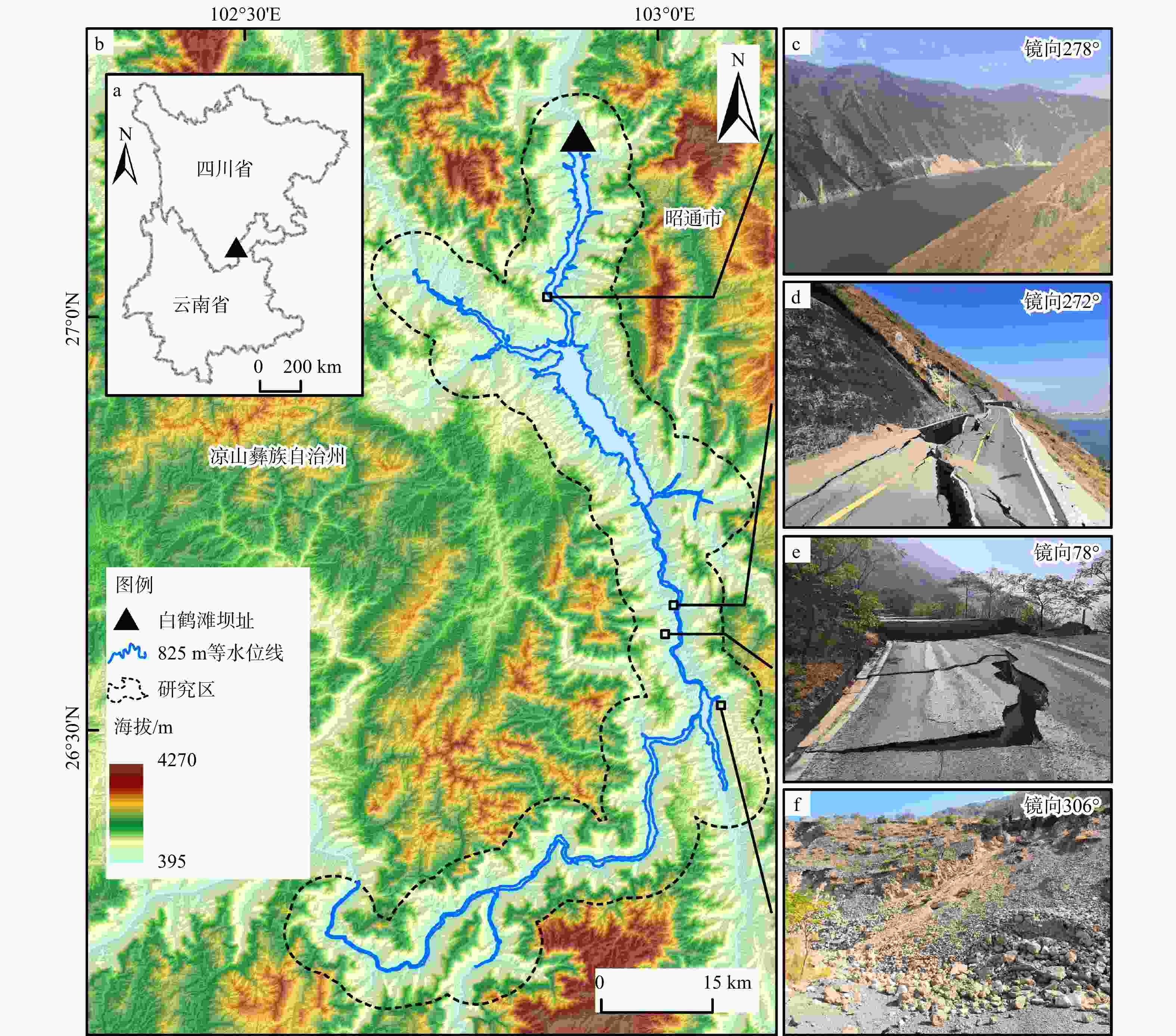
图 1 研究区概况图
基于国家地理信息公共服务平台GS(2024)0650号标准地图制作,底图边界无修改a—白鹤滩水电站地理位置;b—研究区范围及海拔;c—不稳定区域1实景照片;d—不稳定区域2实景照片;e—不稳定区域3实景照片;f—不稳定区域4实景照片
Figure 1. Overview map of the study area
(a) Location of the Baihetan Hydropower Station; (b) Extent and elevation of the study area; (c) Photo of unstable area 1; (d) Photo of unstable area 2; (e) Photo of unstable area 3; (f) Photo of unstable area 4 Fig. 1a is produced based on the standard map (No. GS(2024)0650) from the National Geographic Information Public Service Platform, without modification of the base map boundaries.
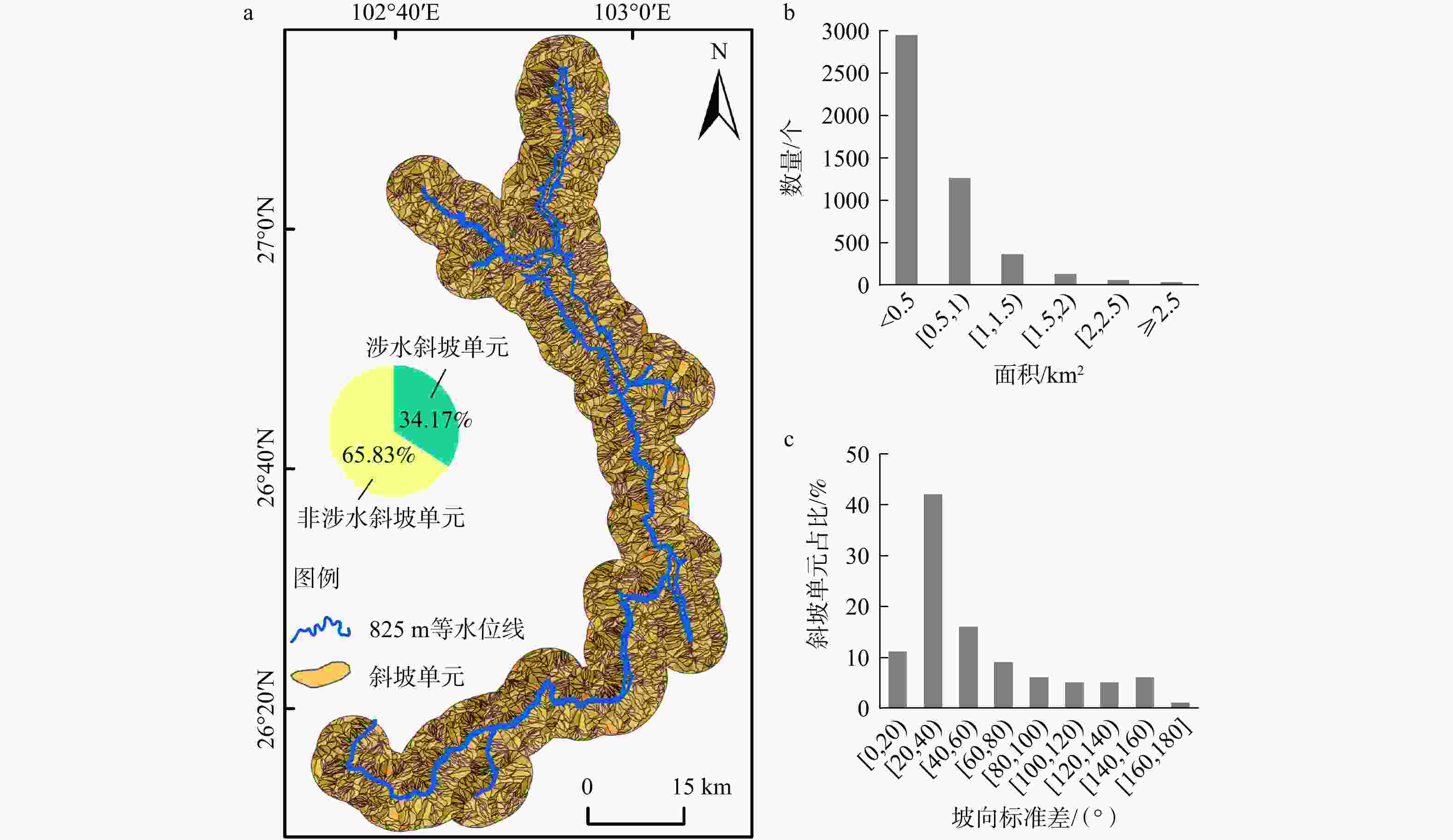
图 3 斜坡单元划分结果及特征
涉水坡体为与825m水位线存在相交情况的斜坡单元a—斜坡单元;b—斜坡单元面积−数列特征;c—坡向标准差特征
Figure 3. Slope unit delineation and characteristics
(a) Slope units; (b) Area–sequence characteristics of slope units; (c) Aspect standard deviation characteristics Water-influenced slopes refer to those intersecting with the 825 m water level contour.
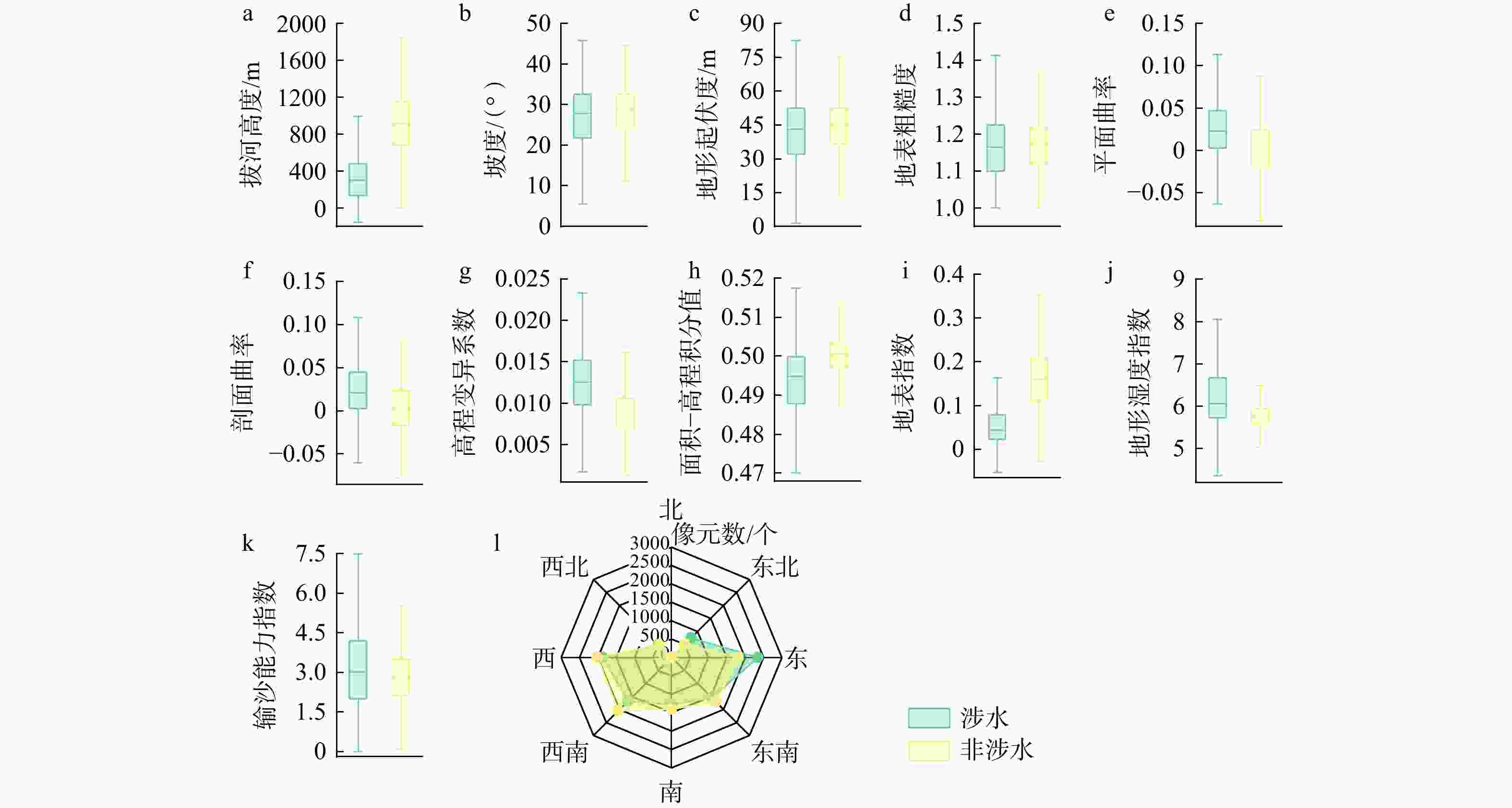
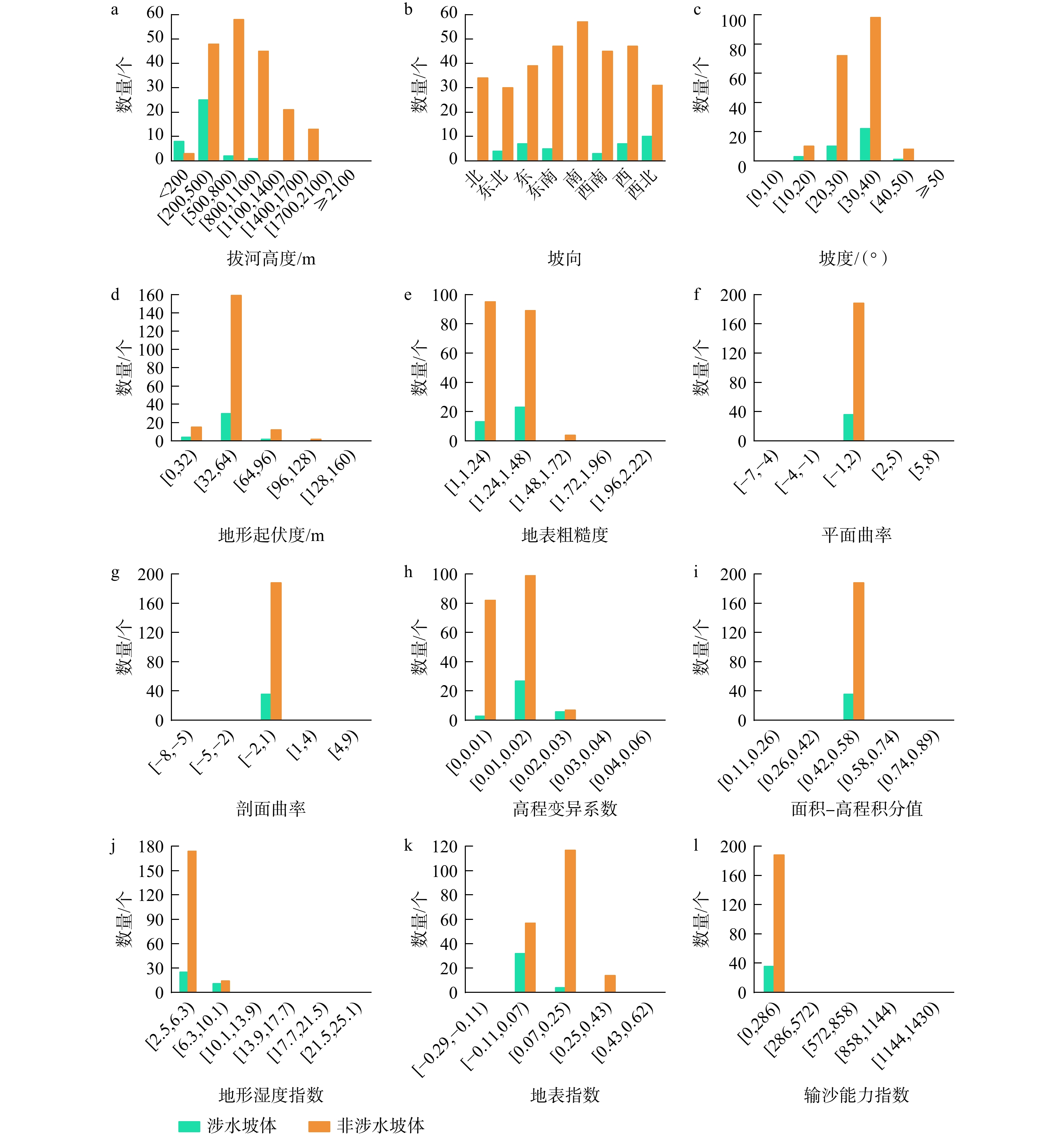
图 4 地貌参数数值分布情况
a—拔河高度数值分布;b—坡度数值分布;c—地形起伏度数值分布;d—地表粗糙度数值分布;e—平面曲率数值分布;f—剖面曲率数值分布;g—高程变异系数数值分布;h—面积−高程积分值数值分布;i—地表指数数值分布;j—地形湿度指数数值分布;k—输沙能力指数数值分布;l—坡向数值分布
Figure 4. Numerical distribution of geomorphic parameters
(a) Numerical distribution of toe height; (b) Numerical distribution of slope gradient; (c) Numerical distribution of terrain relief; (d) Numerical distribution of surface roughness; (e) Numerical distribution of plan curvature; (f) Numerical distribution of profile curvature; (g) Numerical distribution of elevation coefficient of variation; (h) Numerical distribution of area–elevation integral value; (i) Numerical distribution of surface index; (j) Numerical distribution of topographic wetness index; (k) Numerical distribution of sediment transport capacity index; (l) Numerical distribution of aspect
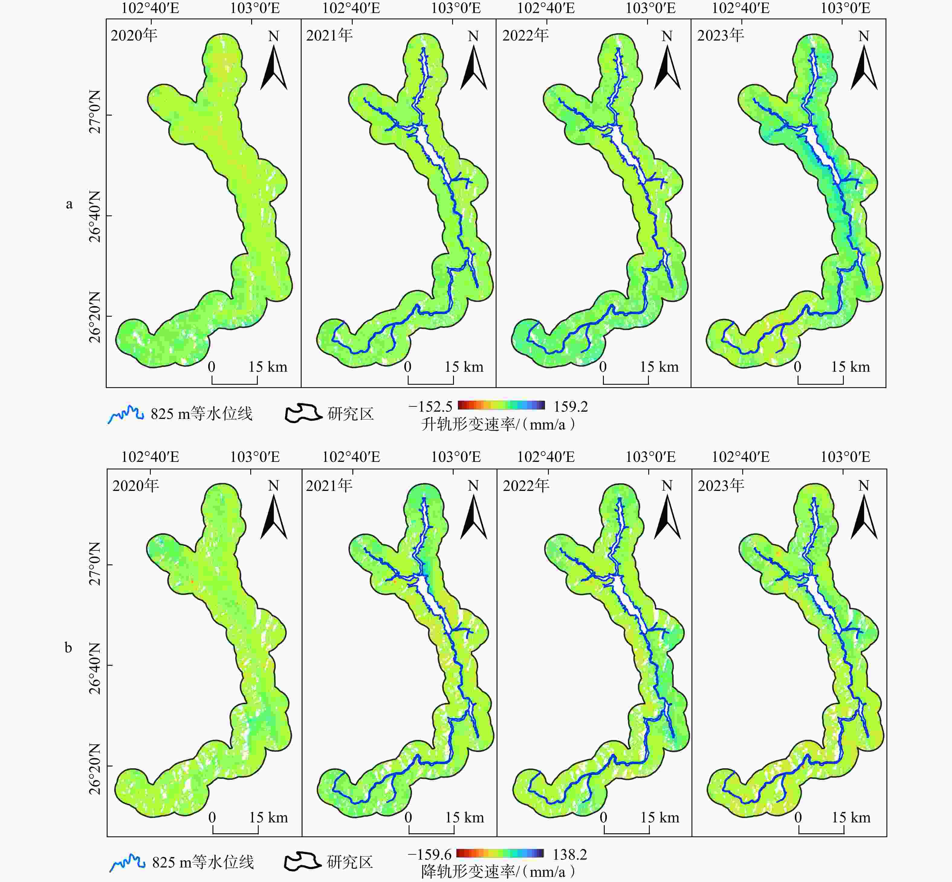
图 5 DS-InSAR监测地表形变速率
a—基于升轨数据;b—基于降轨数据
Figure 5. Surface deformation rates monitored by DS-InSAR
(a) Based on ascending orbit datasets; (b) Based on descending orbit datasets
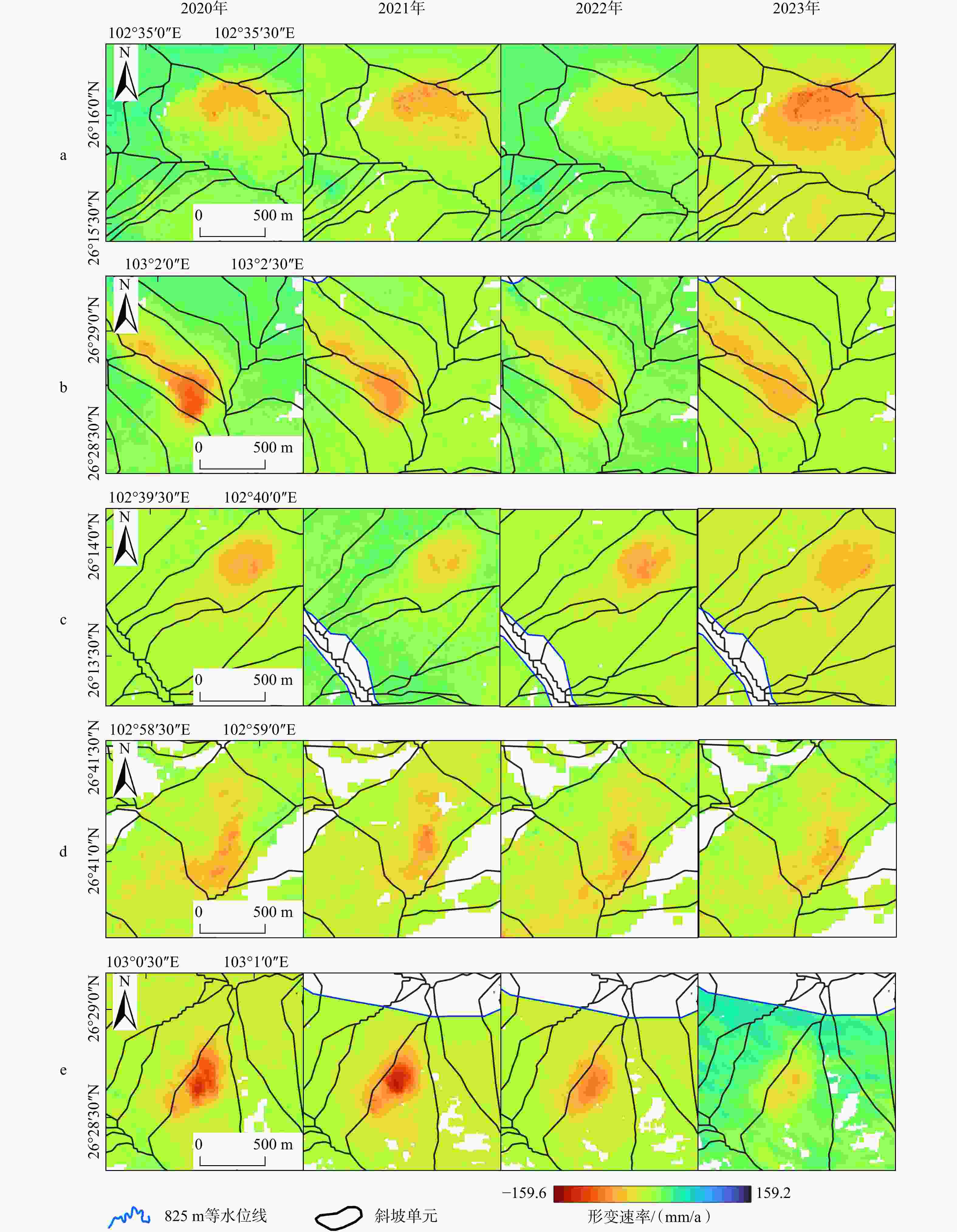
图 6 典型变形坡体的InSAR观测特征
a—典型变形坡体1形变特征;b—典型变形坡体2形变特征;c—典型变形坡体3形变特征;d—典型变形坡体4形变特征;e—典型变形坡体5形变特征
Figure 6. InSAR-monitored characteristics of typical deformed slopes
(a) Deformation characteristics of deformed slope 1; (b) Deformation characteristics of deformed slope 2; (c) Deformation characteristics of deformed slope 3; (d) Deformation characteristics of deformed slope 4; (e) Deformation characteristics of deformed slope 5
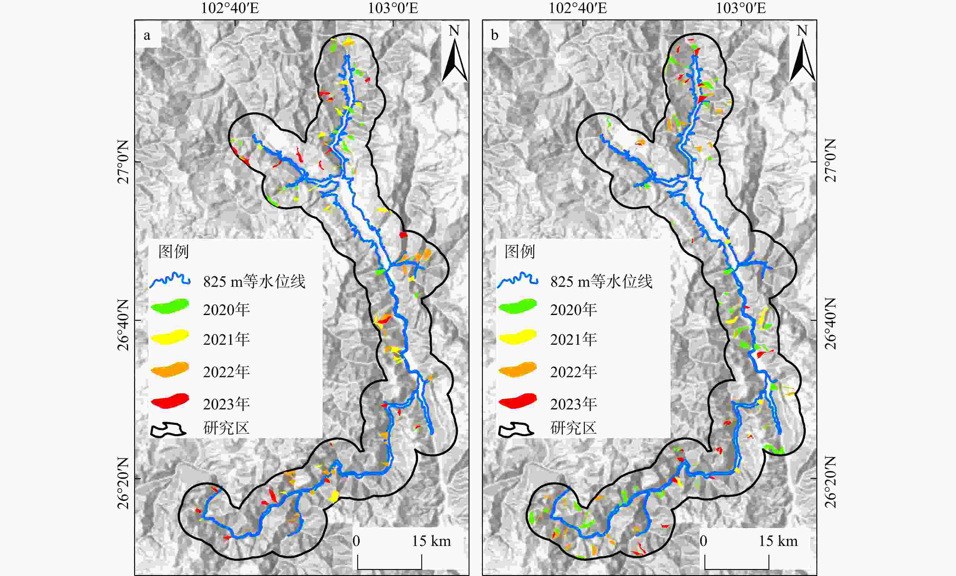
图 7 变形坡体空间分布
a—基于升轨数据识别的变形坡体所在斜坡单元;b—基于降轨数据识别的变形坡体所在斜坡单元
Figure 7. Spatial distribution of deformed slopes
(a) Slope units with deformed slopes identified from ascending orbit datasets; (b) Slope units with deformed slopes identified from descending orbit datasets
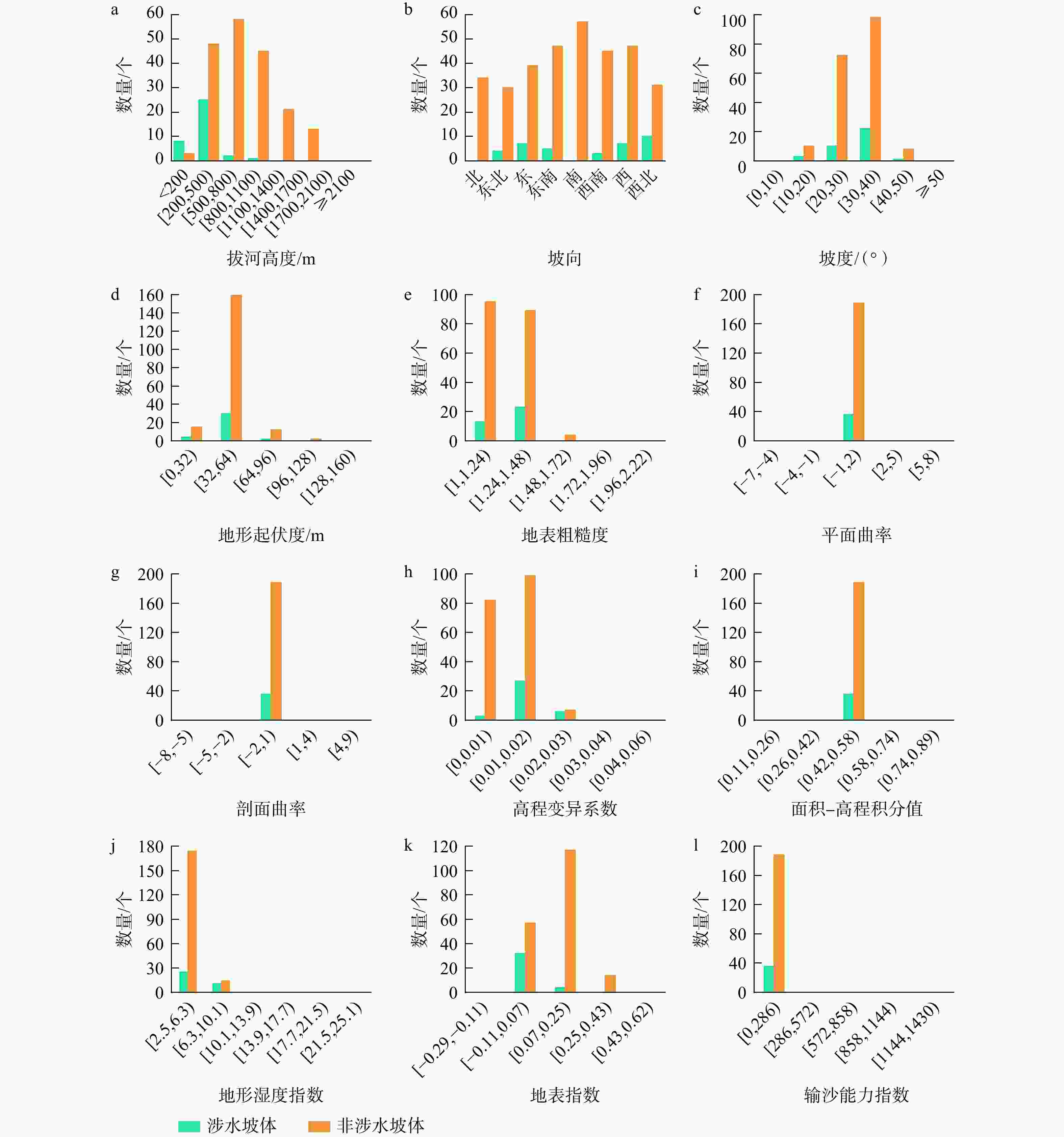
图 8 蓄水与非蓄水触发型变形坡体地貌参数特征
Figure 8. Characteristics of geomorphic parameters for slopes with impoundment-triggered and non-impoundment-triggered deformation
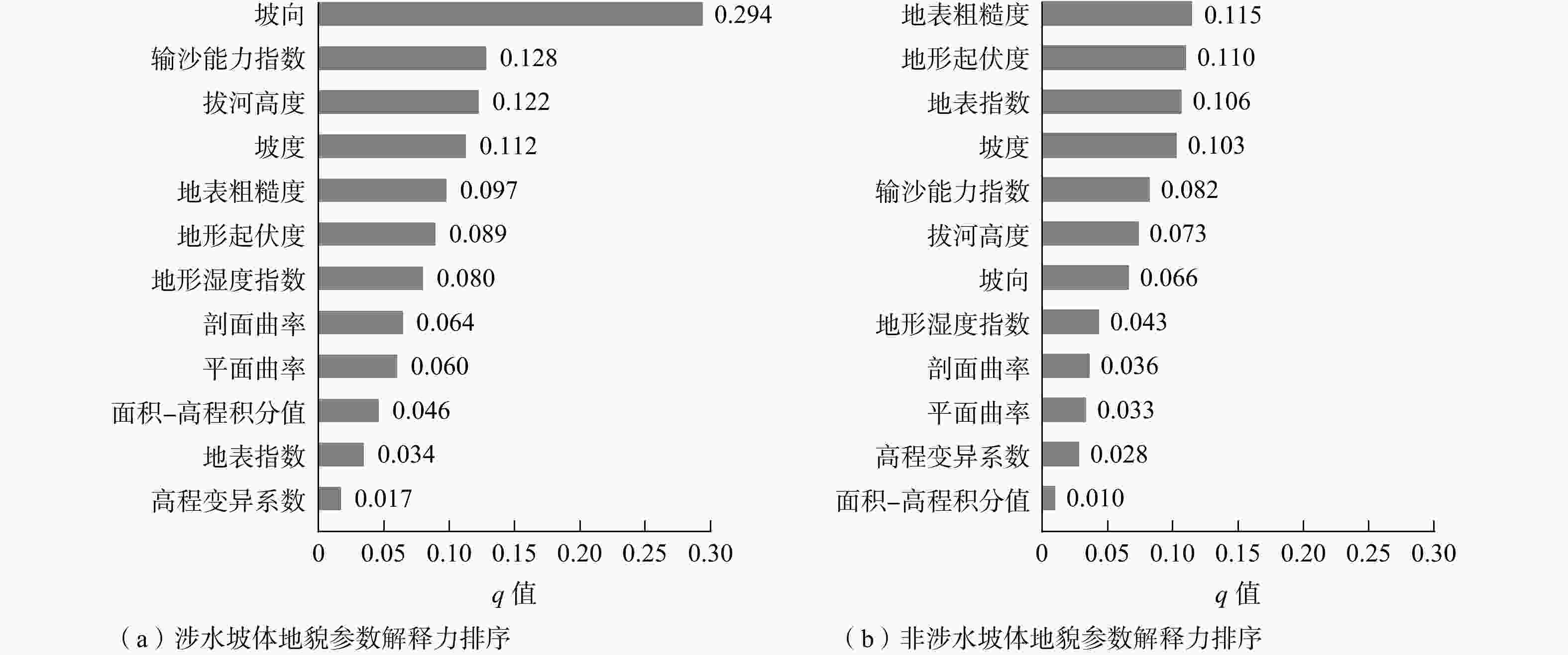
图 9 地貌参数因子解释力(q值)排序
Figure 9. Ranking of the explanatory power (q value) of geomorphic parameters for slopes
(a) Ranking of the explanatory power of geomorphic parameters for water-influenced slopes; (b) Ranking of explanatory power of geomorphic parameters for non-water-influenced slopes
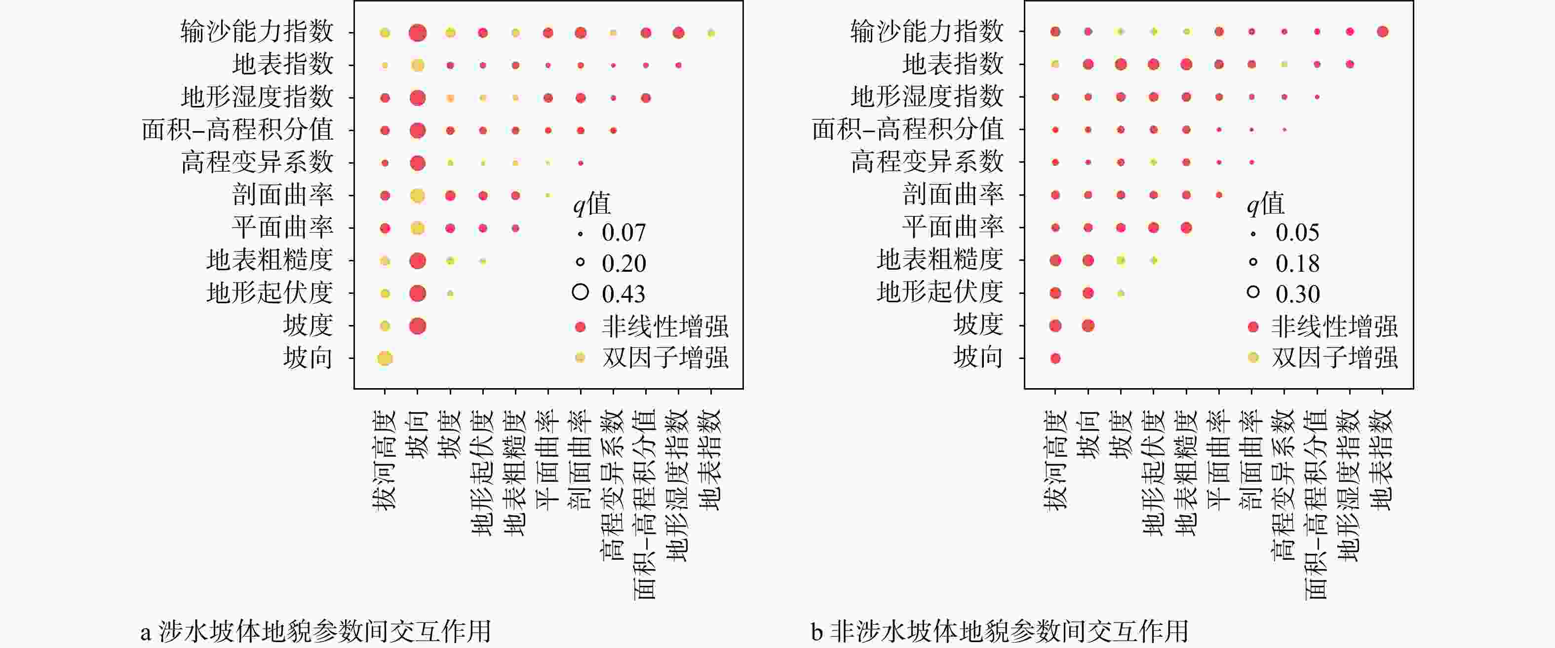
图 10 地貌参数交互作用探测结果
Figure 10. Interaction detection results of geomorphic parameters for slopes
(a) Interaction of geomorphic parameters for water-influenced slopes; (b) Interaction of geomorphic parameters for non-water-influenced slopes
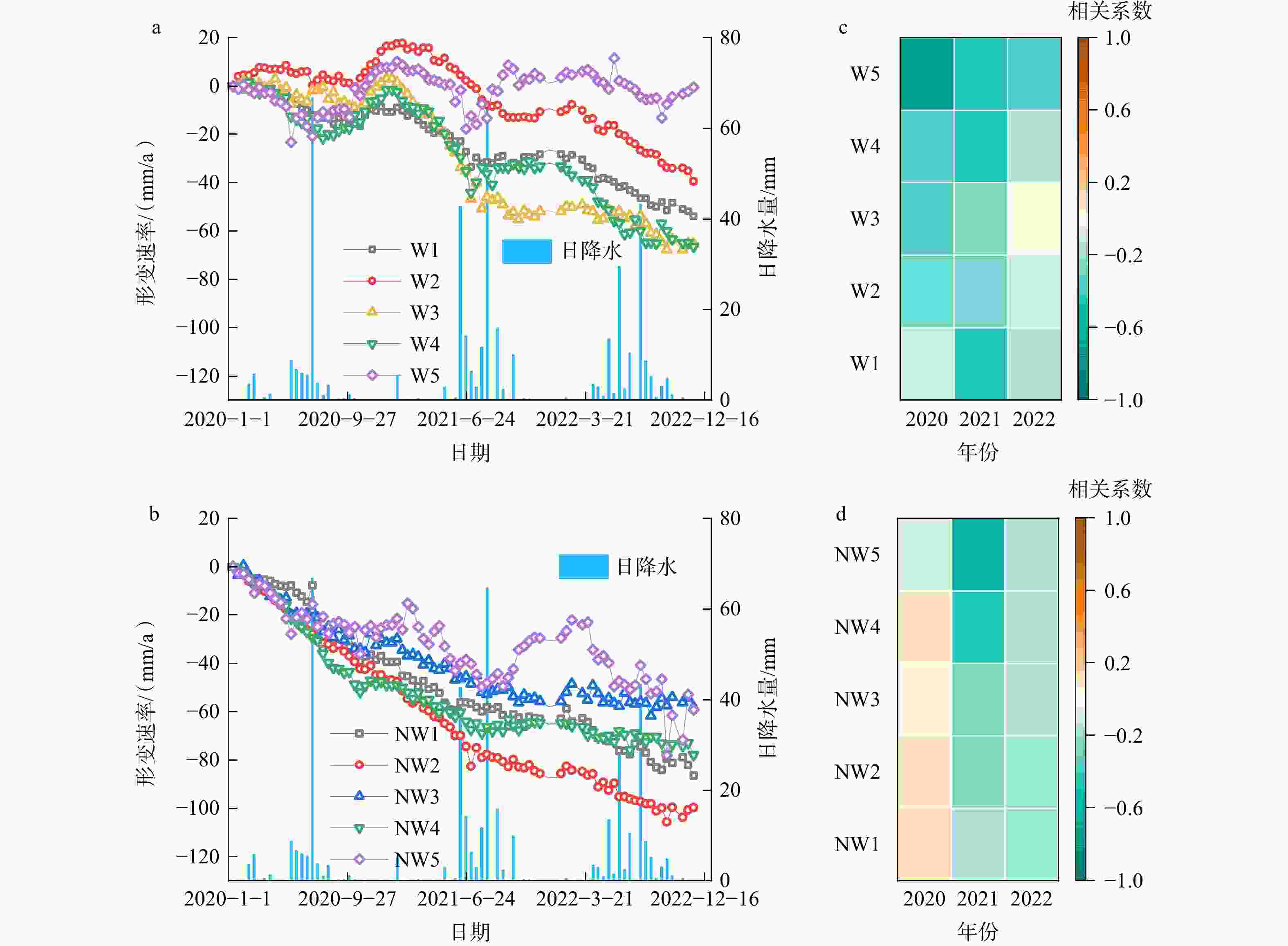
图 11 坡体形变速率及与降水量相关性
a—涉水坡体形变;b—非涉水坡体形变;c—涉水坡体形变与降水相关性;d—非涉水坡体形变与降水相关性
Figure 11. Slope deformation rate and its correlation with precipitation
(a) Deformation rate of water-influenced slopes; (b) Deformation rateof non-water-influenced slopes; (c) Correlation of water-influenced slopes and precipitation; (d) Correlation of non-water-influenced slopes and precipitation
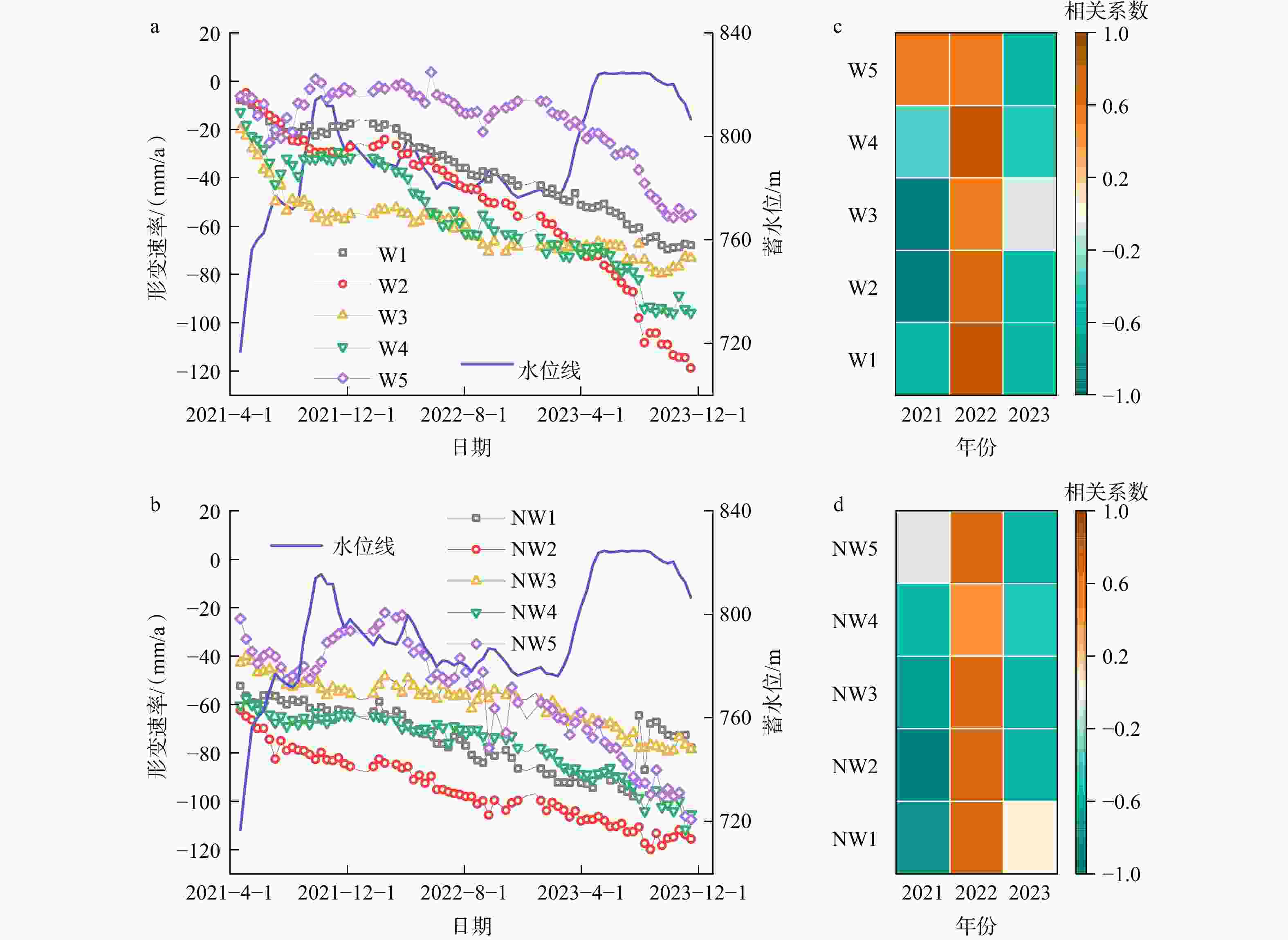
图 12 坡体形变速率及与蓄水位相关性
a—涉水坡体形变;b—非涉水坡体形变;c—涉水坡体形变与蓄水位相关性;d—非涉水坡体形变与蓄水位相关性
Figure 12. Slope deformation rate and its correlation with reservoir level
(a) Deformation rate of water-influenced slopes; (b) Deformation rate of non-water-influenced slopes; (c) Correlation of water-influenced slopes and reservoir level; (d) Correlation of non-water-influenced slopes and reservoir level
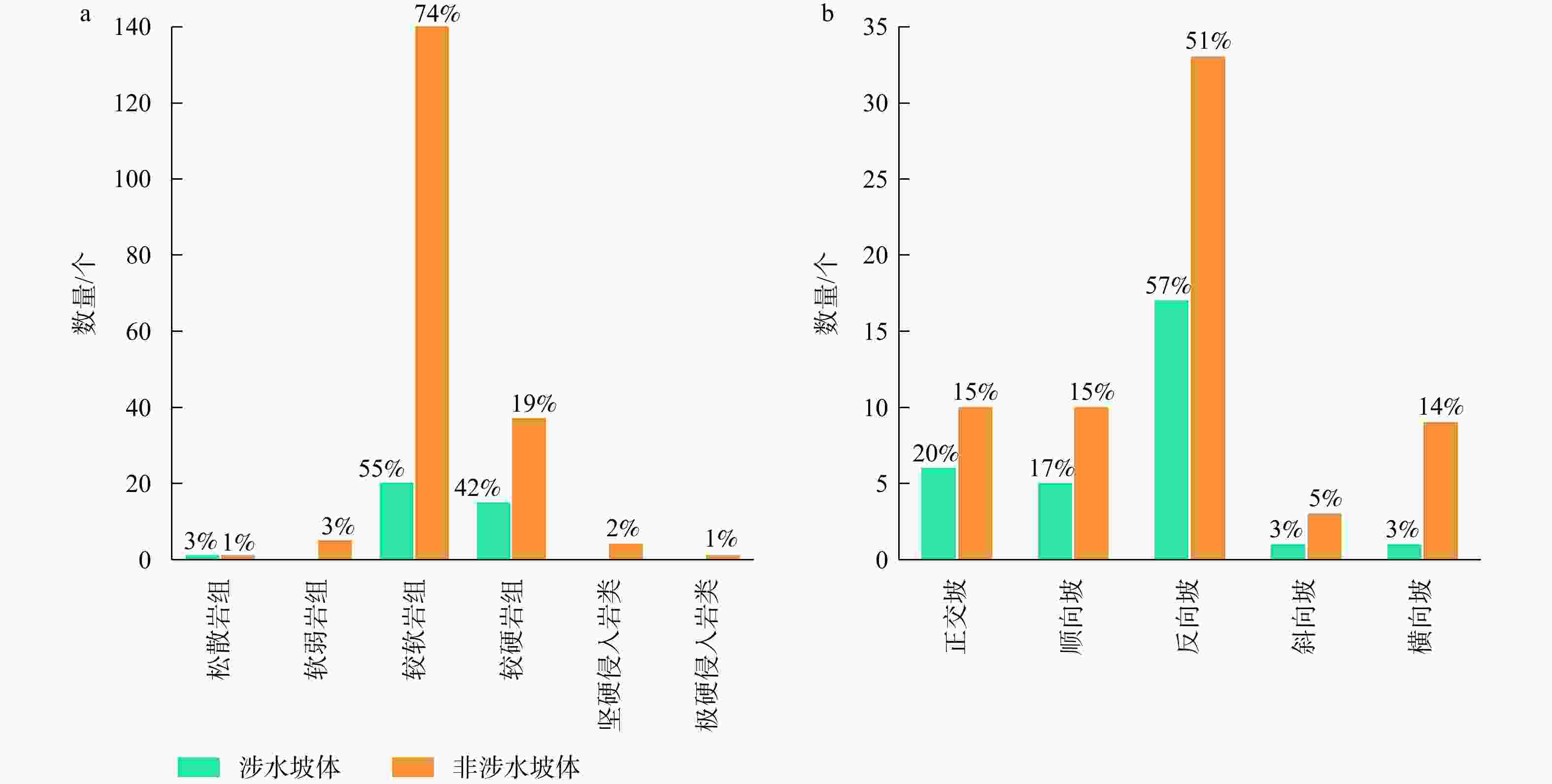
图 13 变形坡体的数量分布
岸坡结构划分依据(覃怡等,2015)为岩层倾向与坡向间的夹角,即顺向坡(0°~20°)、斜向坡(20°~70°)、横向坡(70°~100°)、正交坡(接近90°)和反向坡(> 100°)a—在不同岩组;b—在不同岸坡结构
Figure 13. Distribution of deformed slope counts
(a) In different rock formations; (b) In different slope structures The classification of bank–slope structures is based on the angle betweenthe dip direction of the rock layers and the slope direction, i.e., cis-bank slope (0°–20°), diagonal bank–slope (20°–70°), transverse bank–slope (70°–100°), orthogonal bank–slope (close to 90°), and reverse bank–slope (> 100°) (Qin et al.,2015)
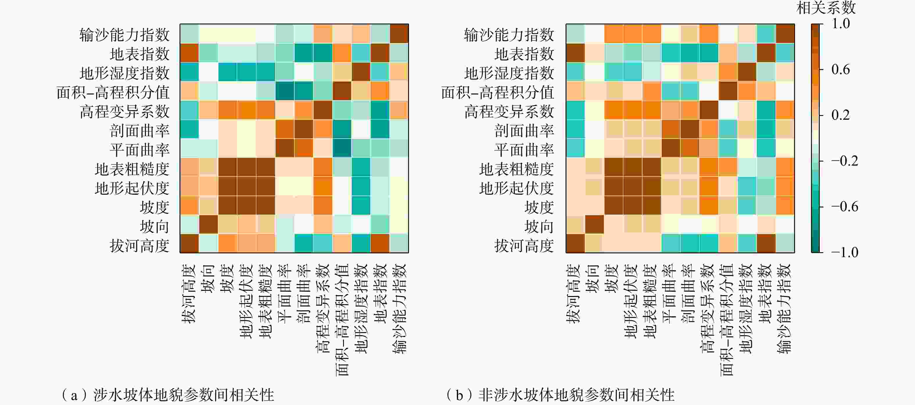
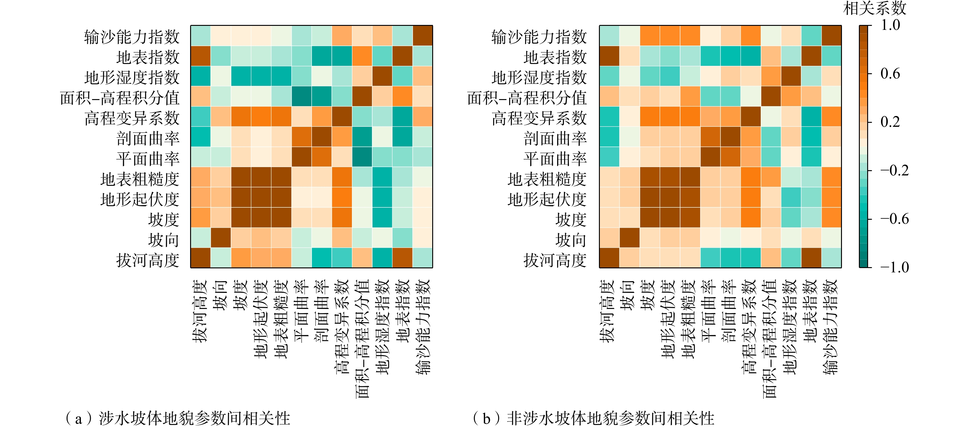
图 14 地貌参数间的相关性
Figure 14. Correlation of geomorphic parameters for slopes
(a) Correlation of geomorphic parameters for water-influenced slopes; (b) Correlation of geomorphic parameters for non-water-influenced slopes
表 1 SAR影像及具体参数
Table 1. Basic parameters of SAR datasets
属性 参数 卫星 Sentinel-1A 波段 C 波长/cm 5.6 成像模式 IW 极化方式 VV 入射角/(°) 43.34(升轨) 39.06(降轨) 方位角/(°) 12.54(升轨) 167.46(降轨) 轨道号 升轨(26) 降轨(62) 距离向及方位向分辨率/m×m 5 × 20 最短时间基线/d 12 影像数量/景 228(升轨) 234(降轨) 时间范围 2020-01-09−2023-12-31(升轨) 2020-01-11−2023-12-21(降轨) 多视参数(方位向∶距离向) 2∶8  下载: 导出CSV
表 2 因子探测结果显著性检验
Table 2. Significance tests for factor detection results
编号 涉水坡体 非涉水坡体 地貌参数 P值 地貌参数 P值 1 坡向 5.80 × 10⁻¹¹ 坡度 5.10 × 10⁻¹¹ 2 输沙能力指数 2.13 × 10⁻⁹ 拔河高度 1.02 × 10⁻¹⁰ 3 坡度 1.11 × 10⁻⁸ 坡向 3.08 × 10⁻¹⁰ 4 地表粗糙度 9.21 × 10⁻⁸ 输沙能力指数 3.78 × 10⁻¹⁰ 5 地形起伏度 3.91 × 10⁻⁷ 地表指数 4.71 × 10⁻¹⁰ 6 拔河高度 1.22 × 10⁻⁵ 地形起伏度 5.31 × 10⁻¹⁰ 7 地形湿度指数 1.71 × 10⁻⁵ 地表粗糙度 6.84 × 10⁻¹⁰ 8 剖面曲率 1.09 × 10⁻⁴ 平面曲率 6.35 × 10⁻⁵ 9 平面曲率 5.51 × 10⁻⁴ 剖面曲率 5.98 × 10⁻³ 10 面积−高程积分值 1.70 × 10⁻³ 高程变异系数 6.66 × 10⁻³ 11 地表指数 8.84 × 10⁻³ 地形湿度指数 8.49 × 10⁻³ 12 高程变异系数 3.97 × 10⁻² 面积−高程积分值 9.05 × 10⁻¹ 注:编号为按显著性检验P值从小到大排序
下载: 导出CSV
表 3 白鹤滩库区蓄水触发岸坡灾变的地貌识别标志
Table 3. Geomorphic signatures of bank–slope disasters triggered by reservoir in the Baihetan Reservoir area
岩性 岸坡结构 地貌参数 较软岩组 反向坡 坡向(西北)、剖面曲率(−2,1)、拔河高度(200 m,500 m) 较软岩组 正交坡 坡向(西北)、地形湿度指数(2.5,6.3)、平面曲率(−1,2) 较软岩组 顺向坡 坡向(西北)、平面曲率(−1,2)、坡度(30°,40°) 较硬岩组 反向坡 坡向(西北)、拔河高度(200 m,500 m)、面积−高程积分值(0.42,0.58) 注:较软岩组包括:凝灰岩、千枚岩、砂质泥岩、泥灰岩、泥质砂岩、粉砂岩、碎屑岩、南方的碳酸盐岩(岩溶发育)等;较硬岩组包括:熔结凝灰岩、大理岩、板岩、白云岩、石灰岩、钙质胶结的砂岩、北部和西部的碳酸盐岩(岩溶不发育)等;标志应用要求:采用30m分辨率DEM时地貌参数提取须基于3×3像元大小的窗口
下载: 导出CSV
-
[1] ALVIOLI M, MARCHESINI I, REICHENBACH P, et al., 2016. Automatic delineation of geomorphological slope units with r. slopeunits v1.0 and their optimization for landslide susceptibility modeling[J]. Geoscientific Model Development, 9(11): 3975-3991. doi: 10.5194/gmd-9-3975-2016 [2] AN X L, MI C L, SUN D L, et al., 2024. Comparison of landslide susceptibility in three gorges reservoir area based on different evaluation units: take Yunyang county in Chongqing as an example[J]. Journal of Jilin University (Earth Science Edition), 54(5): 1629-1644. (in Chinese with English abstract) [3] ANDREANI L, GLOAGUEN R, 2016. Geomorphic analysis of transient landscapes in the Sierra Madre de Chiapas and Maya mountains (northern central America): implications for the north American-Caribbean-Cocos plate boundary[J]. Earth Surface Dynamics, 4(1): 71-102. doi: 10.5194/esurf-4-71-2016 [4] AYALEW L, YAMAGISHI H, UGAWA N, 2004. Landslide susceptibility mapping using GIS-based weighted linear combination, the case in Tsugawa area of Agano River, Niigata Prefecture, Japan[J]. Landslides, 1(1): 73-81. doi: 10.1007/s10346-003-0006-9 [5] BERARDINO P, FORNARO G, LANARI R, et al., 2002. A new algorithm for surface deformation monitoring based on small baseline differential SAR interferograms[J]. IEEE Transactions on Geoscience and Remote Sensing, 40(11): 2375-2383. doi: 10.1109/TGRS.2002.803792 [6] BORGA M, DALLA FONTANA G, CAZORZI F, 2002. Analysis of topographic and climatic control on Rainfall-triggered shallow landsliding using a quasi-dynamic wetness Index[J]. Journal of Hydrology, 268(1-4): 56-71. doi: 10.1016/S0022-1694(02)00118-X [7] BÜRGI P M, LOHMAN R B, 2021. Impact of forest disturbance on InSAR surface displacement time series[J]. IEEE Transactions on Geoscience and Remote Sensing, 59(1): 128-138. doi: 10.1109/TGRS.2020.2992938 [8] CHEN Z M, HU B, CHEN J Z, et al. , 2017. Monitoring the surface deformation caused by oil exploration based on InSAR[J]. Bulletin of Surveying and Mapping(11): 42-46. (in Chinese with English abstract) [9] DAI F C, LEE C F, 2002. Landslide characteristics and slope instability modeling using GIS, Lantau Island, Hong Kong[J]. Geomorphology, 42(3-4): 213-228. doi: 10.1016/S0169-555X(01)00087-3 [10] DAI K R, CHEN C, SHI X L, et al., 2023. Dynamic landslides susceptibility evaluation in Baihetan Dam area during extensive impoundment by integrating geological model and InSAR Observations[J]. International Journal of Applied Earth Observation and Geoinformation, 116: 103157. doi: 10.1016/j.jag.2022.103157 [11] DUN J W, FENG W K, YI X Y, et al., 2023. Early InSAR identification of active landslide before impoundment in Baihetan reservoir area: a case study of Hulukou town Xiangbiling section[J]. Journal of Engineering Geology, 31(2): 479-492. (in Chinese with English abstract) [12] FENG W K, YI X Y, BAI H L, et al., 2021. Prediction and analysis of influence of the first impoundment of Baihetan reservoir on the bank slope stability of Shuanghe river section[J]. Science Technology and Engineering, 21(1): 346-352. (in Chinese with English abstract) [13] FERRETTI A, PRATI C, ROCCA F, 2001. Permanent scatterers in SAR Interferometry[J]. IEEE Transactions on Geoscience and Remote Sensing, 39(1): 8-20. doi: 10.1109/36.898661 [14] FERRETTI A, FUMAGALLI A, NOVALI F, et al., 2011. A new algorithm for processing interferometric data-stacks: SqueeSAR[J]. IEEE Transactions on Geoscience and Remote Sensing, 49(9): 3460-3470. doi: 10.1109/TGRS.2011.2124465 [15] FU G Y, SHE Y W, ZHANG G Q, et al., 2021. Lithospheric equilibrium, environmental changes, and potential induced-earthquake risk around the newly impounded Baihetan reservoir, China[J]. Remote Sensing, 13(19): 3895. doi: 10.3390/rs13193895 [16] GAO B H, HE Y, ZHANG L F, et al., 2023. Dynamic evaluation of landslide susceptibility by CNN considering InSAR deformation: a case study of Liujiaxia reservoir[J]. Chinese Journal of Rock Mechanics and Engineering, 42(2): 450-465. (in Chinese with English abstract) [17] GU W Y, MENG X R, ZHU X C, et al., 2020. Geomorphological classification research based on BEMD decomposition[J]. Journal of Geo-information Science, 22(3): 464-473. (in Chinese with English abstract) [18] GU Z K, YAO X, YAO C C, et al., 2021. Mapping of geomorphic dynamic parameters for analysis of landslide hazards: a case of Yangbi river basin on the upper Lancang-Mekong of China[J]. Journal of Mountain Science, 18(9): 2402-2411. doi: 10.1007/s11629-021-6795-2 [19] HE K Q, GUO L, 2017. Research on the prediction parameter and evaluation method of displacement coupled with water dynamics of the reservoir landslides[J]. Journal of Hydraulic Engineering, 48(5): 516-525. (in Chinese with English abstract) [20] JIN D L, WANG G F, 1988. Tangyanguang landslide in the Zhexi reservoir area[M]//Ground Rock Engineering Professional Committee of the Chinese Society for Rock Mechanics and Engineering, Engineering Geology Professional Committee of the Geological Society of China. Beijing: Science Press: 301-307. (in Chinese) [21] JU N P, HOU W L, ZHAO J J, et al., 2010. Geohazards of Jushui River in the Wenchuan earthquak area[J]. Mountain Research, 28(6): 732-740. (in Chinese with English abstract) [22] LI B L, 2024. Slope deformation monitoring of railroad bridge in mountainous area adjacent to a landslide[J]. Railway Investigation and Surveying, 50(3): 28-33. (in Chinese with English abstract) [23] LI L, XU C, YAO X L, et al., 2022. Large-scale landslides around the reservoir area of Baihetan hydropower station in Southwest China: analysis of the spatial distribution[J]. Natural Hazards Research, 2(3): 218-229. doi: 10.1016/j.nhres.2022.07.002 [24] LI Y J, YUE D X, CHEN G, et al., 2024. A preliminary analysis of the process and cause of the Jintian-Caotan landslide-mudflow hazard chain induced by the Jishishan earthquake[J]. Journal of Lanzhou University (Natural Sciences), 60(1): 1-5. (in Chinese with English abstract) [25] LIAO Q L, LI X, LI S D, et al., 2005. Occurrence, geology and geomorphy characteristics and origin of Qianjiangping landslide in Three Gorges reservoir area and study on ancient landslide criterion[J]. Chinese Journal of Rock Mechanics and Engineering, 24(17): 3146-3153. (in Chinese with English abstract) [26] LIN M L, WANG J F, CHEN Y C, et al. , 2021. Potential analysis of deep-seated landslides caused by Typhoon Morakot using slope unit[M]//GUZZETTI F, ARBANAS S M, REICHENBACH P, et al. Understanding and Reducing Landslide Disaster Risk. Cham: Springer: 173-183. [27] LIU H F, LUO Y H, FENG W K, et al., 2023. Site response of ancient landslides to initial impoundment of Baihetan Reservoir (China) based on ambient noise Investigation[J]. Soil Dynamics and Earthquake Engineering, 164: 107590. doi: 10.1016/j.soildyn.2022.107590 [28] LIU X J, ZHAO C Y, ZHANG Q, et al., 2021. Integration of Sentinel-1 and ALOS/PALSAR-2 SAR datasets for mapping active landslides along the Jinsha River corridor, China[J]. Engineering Geology, 284: 106033. doi: 10.1016/j.enggeo.2021.106033 [29] LIU Y, YAO X, GU Z K, et al., 2024. Research on automatic recognition of active landslides using InSAR deformation under digital morphology: a case study of the Baihetan reservoir, China[J]. Remote Sensing of Environment, 304: 114029. doi: 10.1016/j.rse.2024.114029 [30] LONG R, LIU X D, 2023. Study on stability evaluation and treatment scheme of highway landslide based on disaster mechanism analysis[J]. Railway Investigation and Surveying, 49(2): 33-37. (in Chinese with English abstract) [31] LU H Y, LI W L, XU Q, et al., 2019. Early detection of landslides in the upstream and downstream areas of the Baige landslide, the Jinsha river based on optical remote sensing and InSAR technologies[J]. Geomatics and Information Science of Wuhan University, 44(9): 1342-1354. (in Chinese with English abstract) [32] LÜ B R, PENG L, LI Q M, 2022. Landslide susceptibility evaluation considering sample sensitivity[J]. Bulletin of Surveying and Mapping(11): 20-25. (in Chinese with English abstract) [33] MCKEAN J, ROERING J, 2004. Objective landslide detection and surface morphology mapping using High-resolution airborne laser Altimetry[J]. Geomorphology, 57(3-4): 331-351. doi: 10.1016/S0169-555X(03)00164-8 [34] MICHEL R, AVOUAC J P, TABOURY J, 1999. Measuring ground displacements from SAR amplitude images: application to the Landers earthquake[J]. Geophysical Research Letters, 26(7): 875-878. doi: 10.1029/1999GL900138 [35] MOORE I D, WILSON J P, 1992. Length-slope factors for the revised universal soil loss equation: simplified method of estimation[J]. Journal of Soil and Water Conservation, 47(5): 423-428. doi: 10.1080/00224561.1992.12456740 [36] MÜLLER-SALZBURG L, 1987. The Vajont catastrophe: a personal review[J]. Engineering Geology, 24(1-4): 423-444. doi: 10.1016/0013-7952(87)90078-0 [37] OUYANG X, 2011. Study on regional terrain factors of soil erosion[D]. Xi’an: Northwest University. (in Chinese with English abstract) [38] QIN Y, XIANG N, JIANG W X, 2015. Statistical analysis for landsliding characteristic parameters in Xiangjiaba reservoir area[J]. Technology of Highway and Transport(3): 5-8. (in Chinese with English abstract) [39] SHE Y W, FU G Y, ZHAO Q, et al., 2021. Simulating changes of gravity and coulomb stress caused by the impoundment of the Baihetan hydropower station[J]. Chinese Journal of Geophysics, 64(6): 1925-1936. (in Chinese with English abstract) [40] SHI X L, JU A H, DAI K R, et al., 2023. Deformation evolution and reactivation mechanism of landslide revealed based on multi-source remote sensing during impoundment period for Wulipo landslide in Baihetan reservoir area[J]. Transactions of Beijing institute of Technology, 43(11): 1164-1175. (in Chinese with English abstract) [41] SONG Y Z, WANG J F, GE Y, et al., 2020. An optimal parameters-based geographical detector model enhances geographic characteristics of explanatory variables for spatial heterogeneity analysis: cases with different types of spatial data[J]. GIScience & Remote Sensing, 57(5): 593-610. [42] STEGER S, MAIR V, KOFLER C, et al., 2021. Correlation does not imply geomorphic causation in data-driven landslide susceptibility modelling−benefits of exploring landslide data collection effects[J]. Science of the Total Environment, 776: 145935. doi: 10.1016/j.scitotenv.2021.145935 [43] SU X J, ZHANG Y, MENG X M, et al., 2024. Potential landslides identification and development characteristics analysis in Hunza valley, along China-Pakistan Economic Corridor based on SBAS-InSAR[J]. National Remote Sensing Bulletin, 28(4): 885-899. (in Chinese with English abstract) [44] TANG F J, QI S W, GUO S F, et al., 2022. Spatio-temporal distribution pattern and susceptibility of reservoir-induced landslides in Xiluodu Hydropower Station[J]. Journal of Engineering Geology, 30(3): 609-620. (in Chinese) [45] TANG F J, QI S W, GUO S F, et al., 2025. The influence of reservoirs on landslide erosion[J]. Remote Sensing, 17(4): 569. doi: 10.3390/rs17040569 [46] TANG X G, WANG L J, WANG H Y, et al., 2024. Predicted climate change will increase landslide risk in Hanjiang River basin, China[J]. Journal of Earth Science, 35(4): 1334-1354. doi: 10.1007/s12583-021-1511-2 [47] WANG J B, LIU W, ZHAO M H, et al., 2023. Characteristics and interaction of spatial expansion and natural disasters in the Guangdong-Hong Kong-Macao Greater Bay Area[J]. Science Technology and Engineering, 23(25): 11027-11040. (in Chinese with English abstract) [48] WANG J F, XU C D, 2017. Geodetector: principle and prospective[J]. Acta Geographica Sinica, 72(1): 116-134. (in Chinese with English abstract) [49] WANG K, ZHANG S J, WEI F Q, 2020. Slope unit extraction methods: advances and prospects[J]. Journal of Yangtze River Scientific Research Institute, 37(6): 85-93. (in Chinese with English abstract) [50] WANG S, HUANG W L, XIANG W, et al., 2022. Landslide roughness chronology method: Taking Xieliupo and Suo'ertou landslides in Zhouqu area of Gansu, China as examples[J]. Journal of Earth Sciences and Environment, 44(6): 1037-1047. (in Chinese with English abstract) [51] WU C Y, QIAO J P, 2005. The contributing rate research of slope aspect to landslide growth from Yunyang to Wushan in Three Gorges reservoir region[J]. Journal of Sichuan University (Engineering Science Edition), 37(4): 25-29. (in Chinese with English abstract) [52] WU H, PEI X J, CUI S H, et al., 2021. Study of topographic and geological controls on landslide development and distribution within mountainous regions influenced by strong earthquakes[J]. Chinese Journal of Rock Mechanics and Engineering, 40(5): 972-986. (in Chinese with English abstract) [53] WU X T, DENG H, ZHANG W J, et al., 2022. Evaluation of landslide susceptibility based on automatic slope unit division[J]. Mountain Research, 40(4): 542-556. (in Chinese with English abstract) [54] YAO C C, YAO X, GU Z K, et al., 2022. Analysis on the development law of active geological hazards in the Loess Plateau based on InSAR identification[J]. Journal of Geomechanics, 28(2): 257-267. (in Chinese with English abstract) [55] YAO J M, LAN H X, LI L P, et al., 2022. Characteristics of a rapid landsliding area along Jinsha River revealed by multi-temporal remote sensing and its risks to Sichuan-Tibet Railway[J]. Landslides, 19(3): 703-718. doi: 10.1007/s10346-021-01790-7 [56] YAO X, DENG J H, LIU X H, et al., 2020. Primary recognition of active landslides and development rule analysis for pan Three-river-parallel territory of Tibet Plateau[J]. Advanced Engineering Sciences, 52(5): 16-37. (in Chinese with English abstract) [57] YU W X, LI X Z, ZHENG L J, et al., 2024. Application of the SBAS technique in potential landslide area identification along the KKH of China-Pakistan economic corridor[J]. Journal of Engineering Geology, 32(5): 1597-1606. (in Chinese with English abstract) [58] YUAN Z Y, TANG X C, 2003. The influence of sluice and water level fluctuation on landslides and rockfalls of the Three Gorges project and principles of prevention[J]. Tropical Geography, 23(1): 30-34. (in Chinese with English abstract) [59] ZENG S, MA Z G, ZHAO C, et al., 2023. Multi-source remote sensing recognition of reactivation characteristics of an ancient landslide group at Taipingqiao in the Dadu River Catchment, Eastern Tibetan Plateau[J]. Geoscience, 37(4): 994-1003. (in Chinese with English abstract) [60] ZHANG J T, ZHANG L M, XU T, 2015. Heterogeneity measure based segmentation performance evaluation for remote sensing image[J]. Journal of Geomatics Science and Technology, 32(5): 479-482, 488. (in Chinese with English abstract) [61] ZHAO P, WEN G, HE Z C, et al, 2024. Shallow landslide susceptibility assessment in Jinsha River Basin based on machine learning models[J]. Water Resources and Hydropower Engineering, 55(10): 53-70. (in Chinese with English abstract) [62] ZHOU H F, FANG T, XIA C H, et al., 2023. Reactivation characteristics and mechanism of engineering disturbed Dumi landslide in western Sichuan Province, China[J]. Geoscience, 37(4): 1044-1053. (in Chinese with English abstract) [63] ZHOU L Q, ZHAO C P, ZHANG M, et al., 2022. Machine-learning-based earthquake locations reveal the seismogenesis of the 2020 Mw 5.0 Qiaojia, Yunnan earthquake[J]. Geophysical Journal International, 228(3): 1637-1647. [64] ZHU Y R, QIU H J, LIU Z J, et al., 2024. Rainfall and water level fluctuations dominated the landslide deformation at Baihetan Reservoir, China[J]. Journal of Hydrology, 642: 131871. doi: 10.1016/j.jhydrol.2024.131871 [65] 安雪莲, 密长林, 孙德亮, 等, 2024. 基于不同评价单元的三峡库区滑坡易发性对比: 以重庆市云阳县为例[J]. 吉林大学学报(地球科学版), 54(5): 1629-1644. [66] 陈志谋, 胡波, 陈金座, 等, 2017. 利用InSAR技术监测石油开采引起的地表形变[J]. 测绘通报(11): 42-46. [67] 顿佳伟, 冯文凯, 易小宇, 等, 2023. 白鹤滩库区蓄水前活动性滑坡InSAR早期识别研究: 以葫芦口镇至象鼻岭段为例[J]. 工程地质学报, 31(2): 479-492. [68] 冯文凯, 易小宇, 白慧林, 等, 2021. 白鹤滩水库初次蓄水对双河段岸坡稳定性的影响预测分析[J]. 科学技术与工程, 21(1): 346-352. [69] 高秉海, 何毅, 张立峰, 等, 2023. 顾及InSAR形变的CNN滑坡易发性动态评估: 以刘家峡水库区域为例[J]. 岩石力学与工程学报, 42(2): 450-465. [70] 顾文亚, 孟祥瑞, 朱晓晨, 等, 2020. 基于BEMD分解的地貌分类研究[J]. 地球信息科学学报, 22(3): 464-473. doi: 10.12082/dqxxkx.2020.190262 [71] 贺可强, 郭璐, 2017. 水库滑坡位移与水动力耦合预测参数及其评价方法研究[J]. 水利学报, 48(5): 516-525. [72] 金德镰, 王耕夫, 1988. 柘溪水库塘岩光滑坡[M]//中国岩石力学与工程学会地面岩石工程专业委员会, 中国地质学会工程地质专业委员会. 中国典型滑坡. 北京: 科学出版社. [73] 巨能攀, 侯伟龙, 赵建军, 等, 2010. 安县雎水河流域地质灾害发育、分布及影响因素[J]. 山地学报, 28(6): 732-740. doi: 10.3969/j.issn.1008-2786.2010.06.013 [74] 李白露, 2024. 某邻近滑坡山区铁路大桥边坡变形监测[J]. 铁道勘察, 50(3): 28-33. [75] 李亚军, 岳东霞, 陈冠, 等, 2024. 积石山地震诱发金田-草滩村滑坡-泥流灾害链过程与成因[J]. 兰州大学学报(自然科学版), 60(1): 1-5. [76] 廖秋林, 李晓, 李守定, 等, 2005. 三峡库区千将坪滑坡的发生、地质地貌特征、成因及滑坡判据研究[J]. 岩石力学与工程学报, 24(17): 3146-3153. doi: 10.3321/j.issn:1000-6915.2005.17.023 [77] 隆然, 刘兴东, 2023. 基于致灾机理分析的公路滑坡稳定性评价及治理方案研究[J]. 铁道勘察, 49(2): 33-37. [78] 陆会燕, 李为乐, 许强, 等, 2019. 光学遥感与InSAR结合的金沙江白格滑坡上下游滑坡隐患早期识别[J]. 武汉大学学报(信息科学版), 44(9): 1342-1354. [79] 吕蓓茹, 彭玲, 李樵民, 2022. 顾及样本敏感性的滑坡易发性评价[J]. 测绘通报(11): 20-25. [80] 欧阳晓, 2011. 区域土壤侵蚀地形指标研究[D]. 西安: 西北大学. [81] 覃怡, 向楠, 江为学, 2015. 向家坝库区滑坡特征参数统计分析[J]. 公路交通技术(3): 5-8. [82] 佘雅文, 付广裕, 赵倩, 等, 2021. 白鹤滩水电站蓄水引起重力与库仑应力变化的模拟研究[J]. 地球物理学报, 64(6): 1925-1936. doi: 10.6038/cjg2021O0163 [83] 史先琳, 居安华, 戴可人, 等, 2023. 多源遥感揭示白鹤滩库区五里坡滑坡蓄水期形变演化与复活机制[J]. 北京理工大学学报, 43(11): 1164-1175. [84] 苏晓军, 张毅, 孟兴民, 等, 2024. 中巴经济走廊洪扎段潜在滑坡SBAS-InSAR早期识别及发育特征分析[J]. 遥感学报, 28(4): 885-899. [85] 唐凤娇, 祁生文, 郭松峰, 等, 2022. 金沙江溪洛渡库区水库诱发滑坡时空分布规律及易发性研究[J]. 工程地质学报, 30(3): 609-620. [86] 王江波, 刘威, 赵梦涵, 等, 2023. 粤港澳大湾区城乡建设空间扩张与自然灾害相互影响[J]. 科学技术与工程, 23(25): 11027-11040. [87] 王劲峰, 徐成东, 2017. 地理探测器: 原理与展望[J]. 地理学报, 72(1): 116-134. doi: 10.11821/dlxb201701010 [88] 王凯, 张少杰, 韦方强, 2020. 斜坡单元提取方法研究进展和展望[J]. 长江科学院院报, 37(6): 85-93. doi: 10.11988/ckyyb.20190210 [89] 王淞, 黄伟亮, 项闻, 等, 2022. 滑坡粗糙度年代学方法: 以甘肃舟曲地区泄流坡和锁儿头滑坡为例[J]. 地球科学与环境学报, 44(6): 1037-1047. [90] 吴彩燕, 乔建平, 2005. 三峡库区云阳-巫山段坡向因素对滑坡发育的贡献率研究[J]. 四川大学学报(工程科学版), 37(4): 25-29. [91] 吴昊, 裴向军, 崔圣华, 等, 2021. 强震山区滑坡发育分布的地形地质控制作用研究[J]. 岩石力学与工程学报, 40(5): 972-986. [92] 吴先谭, 邓辉, 张文江, 等, 2022. 基于斜坡单元自动划分的滑坡易发性评价[J]. 山地学报, 40(4): 542-556. [93] 姚闯闯, 姚鑫, 顾畛逵, 等, 2022. 基于InSAR识别的黄土高原活动性地质灾害发育规律分析[J]. 地质力学学报, 28(2): 257-267. [94] 姚鑫, 邓建辉, 刘星洪, 等, 2020. 青藏高原泛三江并流区活动性滑坡InSAR初步识别与发育规律分析[J]. 工程科学与技术, 52(5): 16-37. [95] 余文秀, 李秀珍, 郑玲静, 等, 2024. 基于SBAS-InSAR技术的中巴公路KKH沿线潜在滑坡区识别研究[J]. 工程地质学报, 32(5): 1597-1606. [96] 袁中友, 唐晓春, 2003. 蓄水和水位变动对三峡库区崩塌滑坡的影响及对策[J]. 热带地理, 23(1): 30-34. doi: 10.3969/j.issn.1001-5221.2003.01.007 [97] 曾帅, 马志刚, 赵聪, 等, 2023. 青藏高原东部大渡河流域太平桥乡古滑坡群复活特征多源遥感识别[J]. 现代地质, 37(4): 994-1003. [98] 张建廷, 张立民, 徐涛, 2015. 遥感图像的异质性测度分割效果评价[J]. 测绘科学技术学报, 32(5): 479-482, 488. doi: 10.3969/j.issn.1673-6338.2015.05.009 [99] 赵鹏, 文刚, 何展昌, 等, 2024. 基于机器学习的金沙江流域浅层滑坡易发性评价[J]. 水利水电技术(中英文), 55(10): 53-70. [100] 周洪福, 方甜, 夏晨皓, 等, 2023. 工程扰动诱发川西杜米滑坡复活变形特征及机理分析[J]. 现代地质, 37(4): 1044-1053. -

 下载:
下载:


计量
- 文章访问数: 1152
- HTML全文浏览量: 340
- PDF下载量: 77
- 被引次数: 0
