Prevention and control of land subsidence and earth fissures in Suzhou–Wuxi–Changzhou region
-
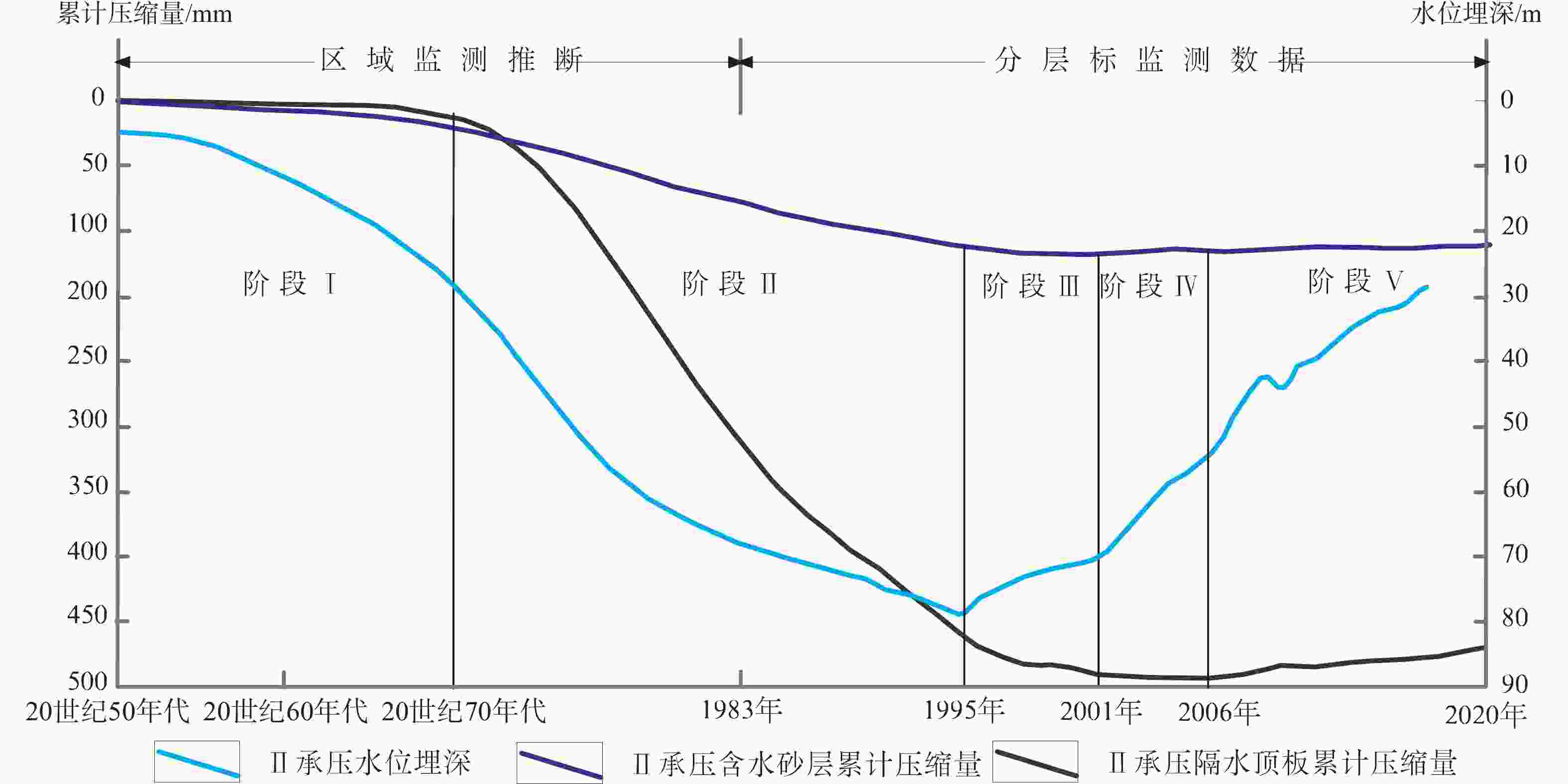
摘要: 苏州—无锡—常州(苏锡常)地区曾是中国地面沉降灾害最严重的地区之一,从20世纪70年代开始发生地面沉降,随之因差异沉降诱发地裂缝灾害,21世纪以来沉降速率逐年趋缓,部分地区出现区域性的地面回弹,独特的地面沉降发展历程为全面解读地面沉降提供了理想的窗口。为揭示苏锡常地区地面沉降生命周期过程及其驱动机制,利用长时间序列、大区域尺度的三维渗流、应力、应变多场监测数据以及物理试验模型、数值模拟等技术对区域地面沉降与地裂缝宏观演变规律、成因机理进行综合分析。研究结果显示:苏锡常地区地面沉降经历了发生、快速发展、趋缓、滞后和反弹5个阶段;地面沉降与地下水开采密切相关,其地层变形主要来自于地下水开采导致的含水层和弱透水层的压密释水,主采含水砂层及相邻隔水层为沉降主要贡献层,并识别了地层压缩、回弹的时空演变特征及其对地面沉降的贡献;地裂缝是地面沉降发展到一定阶段后所产生的次生地质灾害,其空间展布及成灾时间与地下水水位、地面沉降、基岩起伏变化以及土层结构差异等因素密切相关,提出了驱动地裂缝演化的压—拉—剪—弹物理过程,识别出了地裂缝发生的触发机制和临界条件。同时建立了以地质钻孔全断面光纤监测为特色、多种技术方法融合的“天−空−地”立体化、地下水−地面沉降−地裂缝协同的监测体系,为地面沉降防控提供科学、详细的数据支撑;并创新区域−场地双尺度有限元耦合界面元法,成功实现了三维复杂地质环境条件下地层形变特征及地裂缝生成和扩展的力学机制模拟,为地面沉降、地裂缝易发区精准圈定与防控提供了解决路径;通过总结基于技术创新支撑政府实施的地下水限采、禁采等地面沉降防控实践及其成效,为中国其他省/市地面沉降防控与地下水资源管理起到示范作用。Abstract:
Objective The Suzhou–Wuxi–Changzhou region is one of the most severely affected areas by land subsidence, both in China and globally. In the early 1970s, land subsidence occurred and resulted in the formation of ground fissures caused by differential subsidence, thus resulting in significant economic losses. In this century, the rate of ground subsidence has decreased, with some areas experiencing regional ground resilience. The unique developmental history of ground subsidence allows one to comprehensively interpret its evolutionary process and causal mechanisms. This study aims to unravel the life cycle and driving forces of land subsidence in the Suzhou–Wuxi–Changzhou region. Methods To achieve this, a multifaceted approach was employed, including long-term and large-scale monitoring of three-dimensional seepage, stress, and strain, complemented by physical experimental models and numerical simulations. An analysis was conducted to synthesize the macro-evolutionary patterns and causal mechanisms of land subsidence and the formation of ground fissures. Results and Conclusion The findings indicate that land subsidence in the Suzhou–Wuxi–Changzhou region exhibits distinct characteristics that evolve through five discernible stages: initiation, rapid development, deceleration, stagnation, and rebound. The development of land subsidence is intricately connected to groundwater extraction, with stratum deformation arising predominantly from the compaction and dewatering of aquifers and aquitards due to pumping. During the subsidence phase, primary aquifer sand and contiguous aquitards are identified as the primary contributors to subsidence. By dissecting the causal mechanisms of land subsidence and ground fissures, this study delineates the spatiotemporal evolution of the structural compression and rebound of strata under varying conditions of deep groundwater exploitation, restriction, and prohibition, along with their respective contributions to subsidence. Ground fissures, which act as a secondary geological hazard at certain stages of subsidence, exhibit a spatial distribution and occurrence time that are closely related to groundwater levels, land subsidence, bedrock undulations, and soil-layer structural disparities. The life cycle of ground fissures can be encapsulated by the mechanical processes of compression, tension, shearing, and rebound, which highlights the triggers and critical thresholds for fissure formation due to differential subsidence. An integrated “sky–air–ground” monitoring system that can perform full-section fiber-optic monitoring in geological boreholes and amalgamates diverse technical methods is established to obtain scientific and granular data support for land-subsidence control and prevention. Furthermore, an innovative finite-element coupling interface element method customized for regional and site-specific scales is developed. This method successfully simulates the mechanisms of stratum deformation as well as the genesis and propagation of ground fissures under complex three-dimensional geological conditions, thus facilitating the precise identification and management of subsidence and fissure prone areas. Significance This study highlights the government’s land subsidence control measures at various stages, which are characterized by technological innovations such as groundwater extraction restrictions and bans, thus setting a precedent for land subsidence management and groundwater resource stewardship in other provinces and cities across China. -
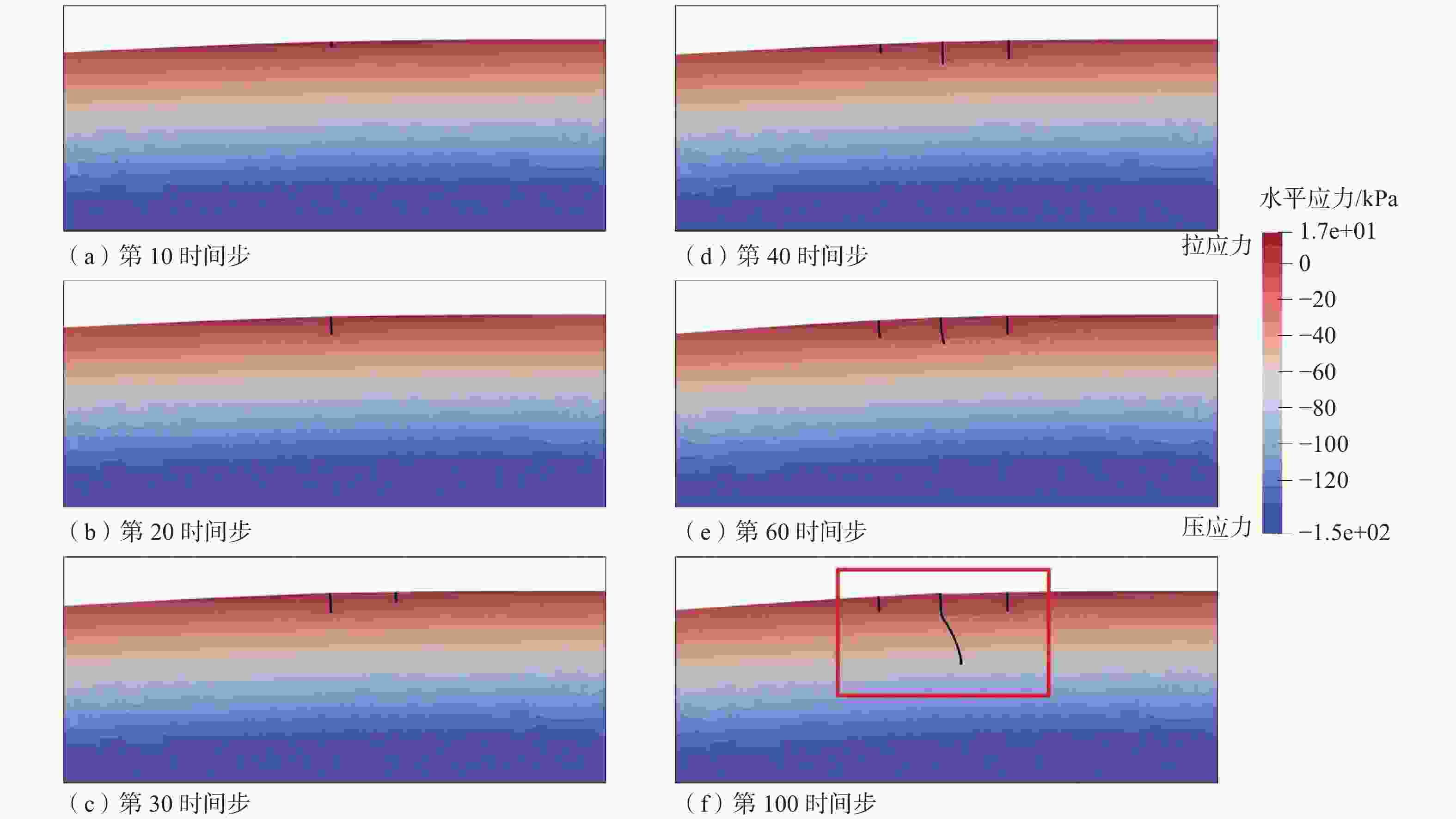
图 19 地裂缝模拟结果(Zhang et al.,2017)
Figure 19. Earth fissure simulation results (Zhang et al.,2017)
(a) Time step 10; (b) Time step 20; (c) Time step 30; (d) Time step 40; (e) Time step 60; (f) Time step 100
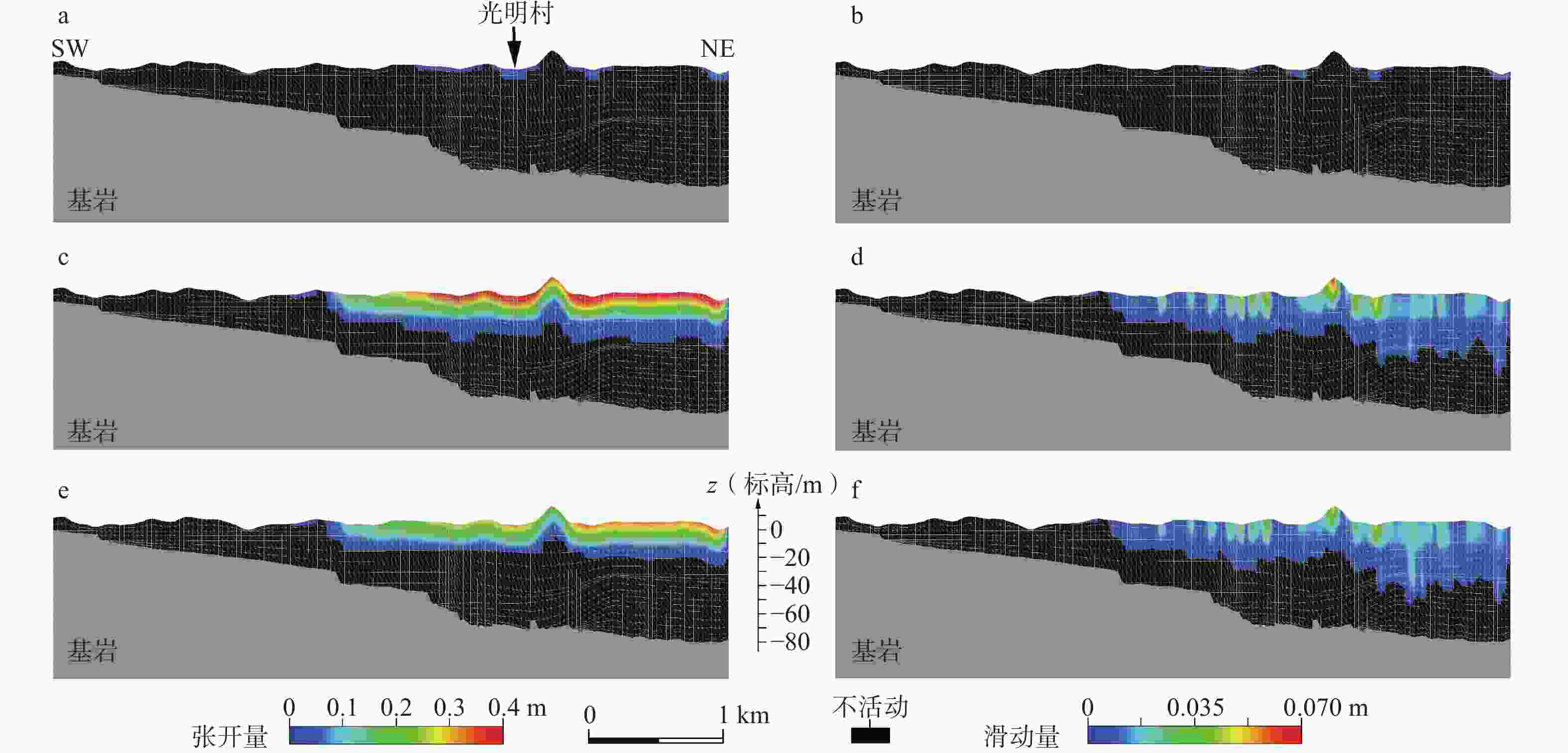
图 20 无锡光明村地裂缝数值模型三维位移图(Ye et al.,2018)
Figure 20. Three-dimensional displacement diagram of numerical modeling of Guangming village earth fissure, Wuxi (Ye et al.,2018)
表 1 苏锡常地区地面沉降发展变化情况
Table 1. List of changes from development of land subsidence in Suzhou–Wuxi–Changzhou region
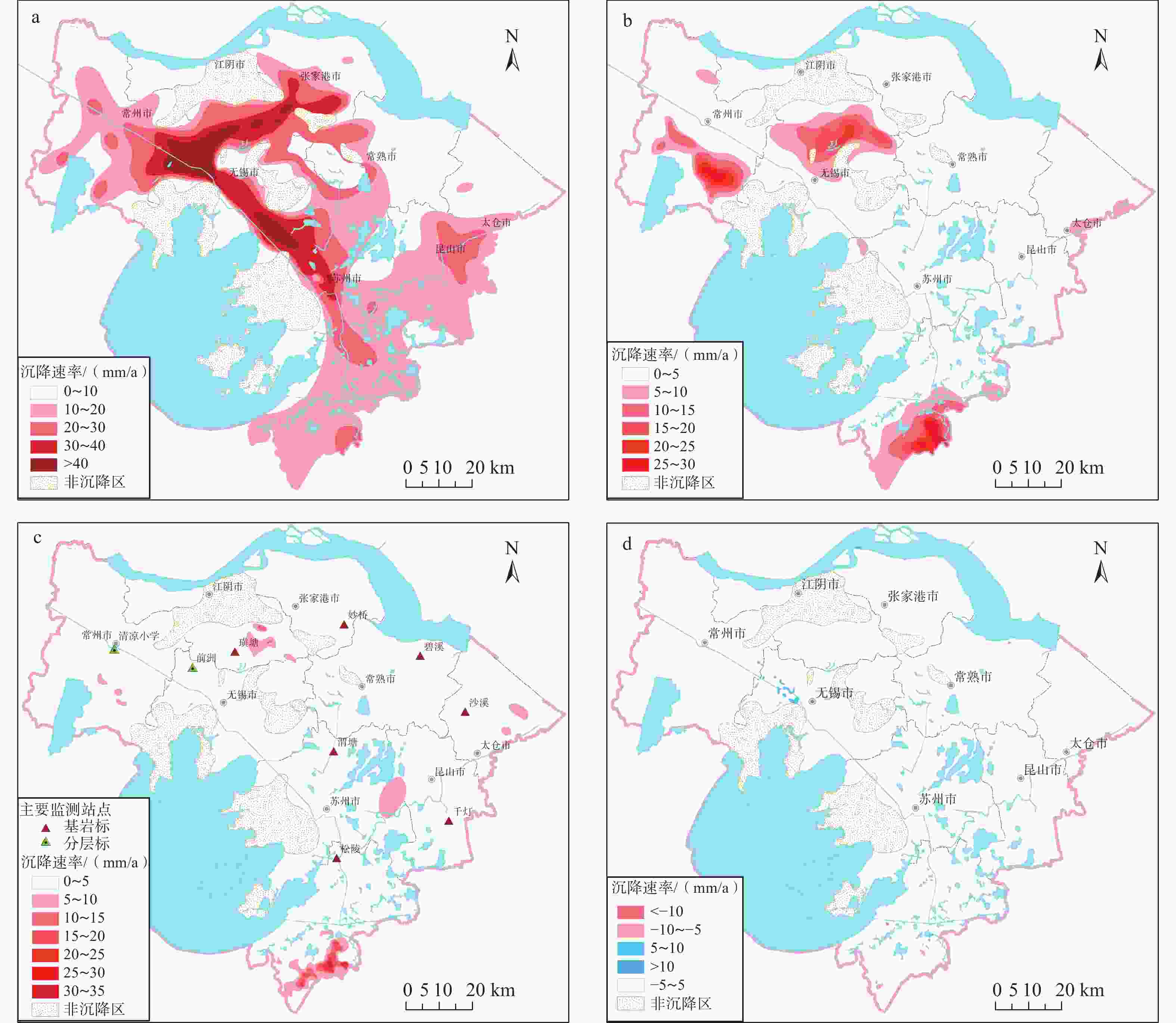
时间 地面沉降漏斗面积/km2 累计沉降量介于200~600mm 累计沉降量介于600~1000mm 累计沉降量>1000mm 1986年 401 108 7 1991年 1473 224 37 2002年 3287 635 401 2022年 3706 708 409 表 2 部分基岩标、分层标水准测量结果
Table 2. Leveling results of bedrock and layered extensometers
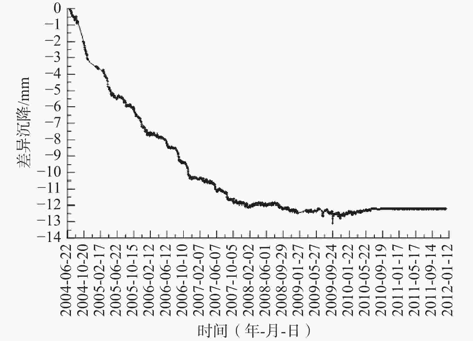
序号 地点 2005年 2006年 2007年 2008年 2009年 2010年 2015年 2020年 1 清凉小学 −4.1 +1.4 +4.9 +9.2 +5.3 +4.87 +8.3 +7.7 2 前洲 −18.3 −10.5 −10.1 −5.3 −1.5 −0.13 +3.7 +7.9 3 璜塘 −15.8 −14.0 −21.5 −14.7 −15.9 −14.1 −0.1 +5.7 4 渭塘 +4.1 −1.4 −1.8 +0.7 −0.4 −1.06 +4.1 +2.7 5 松陵 −6.8 −3.9 −4.0 −3.9 −4.5 −1.38 +0.5 −0.6 注:+表示地面回弹,−表示地面沉降 表 3 常州典型分层标各层形变情况(1984—2023年)
Table 3. Deformation of individual soil layers of layerwise marks in Changzhou
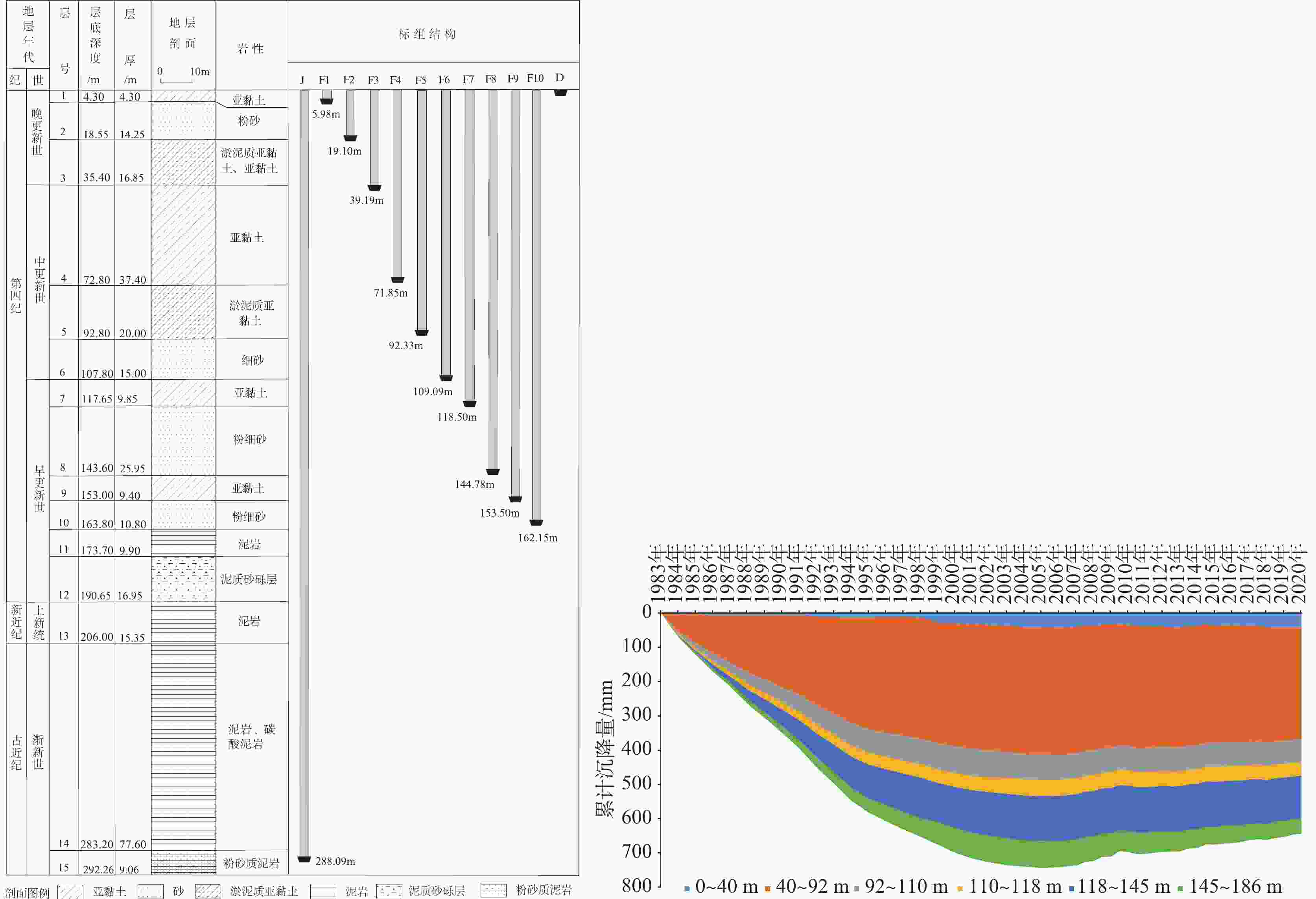
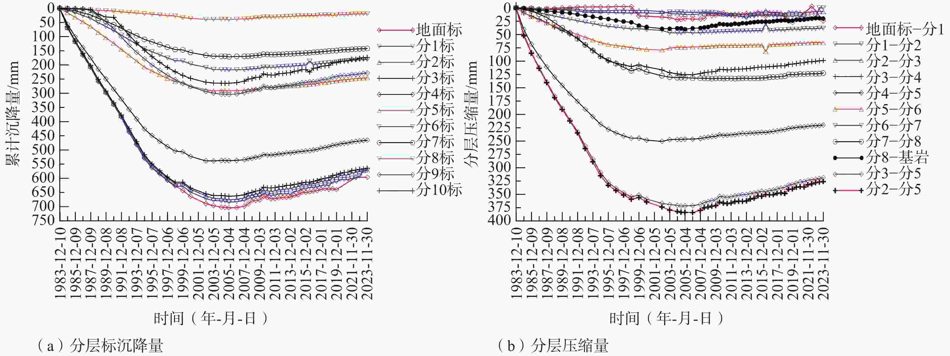
层号 起止深度/m 主要岩性 监测层段 形变情况 1:地面标—分1 0~5.98 亚黏土 第Ⅰ承压含水层顶板 形变量较小,总体稳定 2:分1—分2 5.98~19.10 粉砂 第Ⅰ承压含水砂层 轻微压缩,总体稳定 3:分2—分3 19.1~39.19 淤泥质亚砂土、淤泥质亚黏土、
粉砂和亚黏土第Ⅰ承压隔水底板 1984—2006年累计压缩12.63 mm 2007—2023年累计回弹5.38 mm 4:分3—分4 39.19~71.85 亚黏土 第Ⅱ承压隔水顶板 上段 1984—2006年累计压缩125.29 mm 2007—2023年累计回弹26.38 mm 5:分4—分5 71.85~92.33 淤泥质亚黏土 下段 1984—2002年累计压缩250.65 mm 2003—2023年累计回弹30.82 mm 6:分5—分6 92.33~109.09 细砂、粉砂 第Ⅱ承压含水砂层 1984—2002年累计压缩79.11 mm 2003-2023年累计回弹13.84 mm 7:分6—分7 109.09~118.50 亚黏土 第Ⅱ—Ⅲ承压弱透水层 1984—2004年累计压缩46.97 mm 2005—2023年累计回弹8.88 mm 8:分7—分8 118.50~144.78 粉细砂、细砂夹亚黏土、黏土 第Ⅲ承压含水砂层 1984—2010年累计压缩132.6 mm 2011—2023年累计回弹10.4 mm 9:分8—基岩 144.78~288.09 亚黏土、粉细砂、泥岩、泥质砂砾层 第Ⅲ承压下部地层 1984—2005年累计压缩40.06 mm 2006—2023年累计回弹20.12 mm -
[1] BAWDEN G W, THATCHER W, STEIN R S, et al., 2001. Tectonic contraction across Los Angeles after removal of groundwater pumping effects[J]. Nature, 412(6849): 812-815. doi: 10.1038/35090558 [2] BRAMBATI A, CARBOGNIN L, QUAIA T, et al., 2003. The lagoon of Venice: geological setting, evolution and land subsidence[J]. Episodes, 26(3): 264-268. doi: 10.18814/epiiugs/2003/v26i3/020 [3] CHEN C X, PEI S P, JIAO J, 2003. Land subsidence caused by groundwater exploitation in Suzhou City, China[J]. Hydrogeology Journal, 11(2): 275-287. doi: 10.1007/s10040-002-0225-5 [4] Department of Land and Resources of Jiangsu Province, 2012. Geological disaster prevention and control planning (2011-2020) in Jiangsu province[EB/OL]. (2012-04-06)[2024-03-24]. https://zrzy.jiangsu.gov.cn/gtxxgk/nrglIndex.action?type=2&messageID=2c9082547d5e4398017d5ed727f10008. (in Chinese) [5] GONG X L, GENG J S, SUN Q, et al., 2020. Experimental study on pumping-induced land subsidence and earth fissures: a case study in the Su-Xi-Chang region, China[J]. Bulletin of Engineering Geology and the Environment, 79(9): 4515-4525, doi: 10.1007/s10064-020-01864-1 [6] GUO H P, LI W P, WANG L Y, et al., 2021. Present situation and research prospects of the land subsidence driven by groundwater levels in the North China Plain[J]. Hydrogeology & Engineering Geology, 48(3): 162-171. (in Chinese with English abstract [7] GUO K Y, GUO S Q, YU J, et al. , 2005. Groundwater resources and geohazards surveying and evaluation in Yangtze Delta area[R]. Nanjing Institute of Geology and Mineral Resources, and Jiangsu Geological Survey and Research Institute,Shanghai Institute of Geological Survey, Geological Environment Monitoring Stationof Zhejiang Province, Geological Survey of Zhejiang Province. (in Chinese) [8] HELM D C, 1994. Horizontal aquifer movement in a Theis-Thiem confined system[J]. Water Resources Research, 30(4): 953-964. doi: 10.1029/94WR00030 [9] HERRERA-GARCÍA G, EZQUERRO P, TOMÁS R, et al., 2021. Mapping the global threat of land subsidence[J]. Science, 371(6524): 34-36. doi: 10.1126/science.abb8549 [10] HU Z Q, XU X L, ZHAO Y L, 2012. Dynamic monitoring of land subsidence in mining area from multi-source remote-sensing data – a case study at Yanzhou, China[J]. International Journal of Remote Sensing, 33(17): 5528-5545. doi: 10.1080/01431161.2012.663113 [11] JIANG L M, LIN H, MA J W, et al., 2011. Potential of small-baseline SAR interferometry for monitoring land subsidence related to underground coal fires: Wuda (northern China) case study[J]. Remote Sensing of Environment, 115(2): 257-268. doi: 10.1016/j.rse.2010.08.008 [12] Jiangsu Provincial People's Government, 2015. The approval of groundwater compression exploitation plan (2014-2020): Su Zhengfu [2015] No. 19[EB/OL]. (2015-03-16). https://www.jiangsu.gov.cn/art/2015/3/16/art_46143_2542910.html. (in Chinese) [13] LI C J, TANG X M, MA T H, 2006. Land subsidence caused by groundwater exploitation in the Hangzhou-Jiaxing-Huzhou Plain, China[J]. Hydrogeology Journal, 14(8): 1652-1665. doi: 10.1007/s10040-006-0092-6 [14] LI W, WU J Q, 2015. Research on monitoring method system of land subsidence in Suzhou-Wuxi-Changzhou area[J]. Global Geology, 34(3): 862-869. (in Chinese with English abstract [15] LI Y T, TEATINI P, YU J, et al., 2021. Aseismic multifissure modeling in unfaulted heavily pumped basins: mechanisms and applications[J]. Water Resources Research, 57(10): e2021WR030127, doi: 10.1029/2021WR030127 [16] LI Z, LUO Z J, WANG Q, et al., 2019. A three-dimensional fluid-solid model, coupling high-rise building load and groundwater abstraction, for prediction of regional land subsidence[J]. Hydrogeology Journal, 27(4): 1515-1526. doi: 10.1007/s10040-018-01920-x [17] LIU C, YUAN X J, ZHU J Q, 2004. Earth fissures in Su-Xi-Chang[M]. Wuhan: China University of Geosciences Press. (in Chinese) [18] LIU H P, 2010. The study on the land subsidence with the affect of high-rise buildings in Tianjin Binhai New Area[D]. Xi’an: Chang’an University. (in Chinese with English abstract [19] LIU M Y, ZHANG Q Q, GONG X L, et al. , 2022. Study on soil deformation characteristic and the life process of land subsidence in Changzhou Area of Jiangsu province[J]. Shanghai Land & Resources, 43(4): 50-55, 72. (in Chinese with English abstract [20] LUO Z J, ZHANG X, TIAN X W, 2018. Prediction and early warning of Cangzhou land subsidence disaster[J]. Journal of Engineering Geology, 26(2): 365-373. (in Chinese with English abstract [21] Ministry of Land and Resources, Ministry of Water Resources, 2012. National plan for prevention and control of land subsidence (2011-2020)[EB/OL]. (2012-02-22)[2024-03-24]. https://www.mnr.gov.cn/dt/ywbb/201810/t20181030_2261387.html. (in Chinese) [22] NELSON F E, ANISIMOV O A, SHIKLOMANOV N I, 2001. Subsidence risk from thawing permafrost[J]. Nature, 410(6831): 889-890. doi: 10.1038/35073746 [23] NOTTI D, MATEOS R M, MONSERRAT O, et al., 2016. Lithological control of land subsidence induced by groundwater withdrawal in new urban areas (Granada Basin, SE Spain). Multiband DInSAR monitoring[J]. Hydrological Processes, 30(13): 2317-2331. doi: 10.1002/hyp.10793 [24] PARSONS T, 2021. The weight of cities: Urbanization effects on Earth's subsurface[J]. AGU Advances, 2(1): e2020AV000277. doi: 10.1029/2020AV000277 [25] SAYYAF M, MAHDAVI M, BARANI O R, et al., 2014. Simulation of land subsidence using finite element method: Rafsanjan plain case study[J]. Natural Hazards, 72(2): 309-322. doi: 10.1007/s11069-013-1010-6 [26] SHI X Q, XUE Y Q, WU J C, et al., 2006a. A study of soil deformation properties of the groundwater system in the Changzhou area[J]. Hydrogeology & Engineering Geology, 33(3): 1-6. (in Chinese with English abstract [27] SHI X Q, XUE Y Q, ZHANG Y, et al. , 2006b. Creep model of Changzhou silty clay[J]. Geotechnical Investigation & Surveying, 34(5): 16-18, 70. (in Chinese with English abstract [28] SHI X Q, XUE Y Q, WU J C, et al., 2007. Uniaxial compression tests for creep model of saturated sand in Changzhou[J]. Journal of Engineering Geology, 15(2): 212-216. (in Chinese with English abstract [29] SHI X Q, WU J C, YE S J, et al., 2008. Regional land subsidence simulation in Su-Xi-Chang area and Shanghai city, China[J]. Engineering Geology, 100(1-2): 27-42, doi: 10.1016/j.enggeo.2008.02.011 [30] SHI X Q, FENG Z X, YAO B K, et al., 2014. Study on the deformation characteristics of soil layers after banning groundwater pumping in Su-Xi-Chang area[J]. Quaternary Sciences, 34(5): 1062-1071. (in Chinese with English abstract [31] State Council, 2011. Decision on strengthening the prevention and control of geological hazards: Guo Fa 〔2011〕 No. 20[EB/OL]. (2011-06-13)[2024-03-24]. https://www.gov.cn/zhengce/zhengceku/2011-06/17/content_2744.htm. (in Chinese) [32] SUN X H, PENG J B, CUI X M, et al., 2016. Relationship between ground fissures, groundwater exploration and land subsidence in Taiyuan basin[J]. The Chinese Journal of Geological Hazard and Control, 27(2): 91-98. (in Chinese with English abstract [33] The Standing Committee of Jiangsu Provincial People's Congress, 2021. Decision on prohibiting the exploitation of groundwater in the Suzhou-Wuxi Changzhou area for a limited period of time: bulletin of the standing committee of Jiangsu provincial people's congress. [2000] No. 5[EB/OL]. (2021-10-08)[2024-03-24]. https://www.jsrd.gov.cn/qwfb/sjfg/202110/t20211008_532359.shtml. (in Chinese) [34] WANG G Y, YU J, WU S L, et al., 2009. Land subsidence and compression of soil layers in Changzhou Area[J]. Geology and Exploration, 45(5): 612-620. (in Chinese with English abstract [35] WANG G Y, YOU G, ZHU J Q, et al., 2016. Earth fissures in Su-Xi-Chang region, Jiangsu, China[J]. Surveys in Geophysics, 37(6): 1095-1116. doi: 10.1007/s10712-016-9388-9 [36] WU J Q, WU S L, LI W, et al. , 2009. Construction of risk assessment index system for land subsidence disasters in the Suzhou-Wuxi-Changzhou region[C]//Proceedings of the 2009 academic annual conference of the Chinese geological society. Beijing: Chinese Geological Society: 277-278. (in Chinese) [37] WU J Q, WU S L, MIN W, et al., 2014. Review on recent progress of land subsidence control in Suzhou-Wuxi-Changzhou area[J]. Journal of Geology, 38(2): 319-323. (in Chinese with English abstract [38] XUE Y Q, ZHANG Y, YE S J, et al., 2003. Land subsidence in China and its problems[J]. Quaternary Sciences, 23(6): 585-593. (in Chinese with English abstract [39] XUE Y Q, WU J C, ZHANG Y, et al., 2008. Simulation of regional land subsidence in the southern Yangtze Delta[J]. Science in China Series D: Earth Sciences, 51(6): 808-825. doi: 10.1007/s11430-008-0062-z [40] XUE Y Q, 2012. Discussion on groundwater overexploitation and ground settlement[J]. Ground Water, 34(6): 1-5. (in Chinese with English abstract [41] YAN X X, GONG S L, ZENG Z Q, et al., 2002. Relationship between building density and land subsidence in Shanghai urban zone[J]. Hydrogeology & Engineering Geology, 29(6): 21-25. (in Chinese with English abstract [42] YE S J, 2004. Study on the regional land subsidence model and its application[D]. Nanjing: Nanjing University. (in Chinese with English abstract [43] YE S J, XUE Y Q, 2005. Stress-strain analysis for storage coefficients and vertical hydraulic conductivities of aquitards in Shanghai area[J]. Rock and Soil Mechanics, 26(2): 256-260. (in Chinese with English abstract [44] YE S J, XUE Y Q, ZHANG Y, et al., 2005. Study on the deformation characteristics of soil layers in regional land subsidence model of Shanghai[J]. Chinese Journal of Geotechnical Engineering, 27(2): 140-147. (in Chinese with English abstract [45] YE S J, XUE Y Q, WU J C, et al., 2011. Regional land subsidence model embodying complex deformation[J]. Proceedings of the Institution of Civil Engineers -Water Management, 164(10): 519-531. doi: 10.1680/wama.1000062 [46] YE S J, FRANCESCHINI A, ZHANG Y, et al., 2018. A novel approach to model earth fissure caused by extensive aquifer exploitation and its application to the Wuxi Case, China[J]. Water Resources Research, 54(3): 2249-2269, doi: 10.1002/2017WR021872 [47] YU J, WANG X M, SU X S, et al., 2004. The mechanism analysis on ground fissure disaster formation in Suzhou-Wuxi-Changzhou area[J]. Journal of Jilin University (Earth Science Edition), 34(2): 236-241. (in Chinese with English abstract [48] YU J, WANG X M, WU J Q, et al., 2006. Characteristics of land subsidence and its remedial proposal in Suzhou-Wuxi-Changzhou area[J]. Geological Journal of China Universities, 12(2): 179-184. (in Chinese with English abstract [49] YU J, WU J C, YE S J, et al., 2007. Research on nonlinear coupled modeling of land subsidence in Suzhou, Wuxi and Changzhou areas, China[J]. Hydrogeology & Engineering Geology, 34(5): 11-16. (in Chinese with English abstract [50] YU J, WU J Q, 2008. Preliminary research on risk evaluation management model of land subsidence in Su-Xi-Chang region[J]. Jiangsu Geology, 32(2): 113-117. (in Chinese with English abstract [51] ZHANG Y, WU J C, XUE Y Q, et al., 2017. Fully coupled three-dimensional nonlinear numerical simulation of pumping-induced land movement[J]. Environmental Earth Sciences, 76(16): 552. doi: 10.1007/s12665-017-6891-3 [52] ZHANG Y, YU J, GONG X L, et al., 2018. Pumping-induced stress and strain in aquifer systems in Wuxi, China[J]. Hydrogeology Journal, 26(3): 771-787. doi: 10.1007/s10040-017-1697-7 [53] ZHU J Q, JIAO X, YU J, et al., 2008. Evaluation of earth fissures based on GA-ANN coupling model in the Suzhou-Wuxi-Changzhou area[J]. Hydrogeology & Engineering Geology, 35(4): 106-110. (in Chinese with English abstract [54] ZHU J Q, ZHANG W Q, YU J, et al. , 2016. Hazards of soil cracking and experimental research[M]. Xuzhou: China University of Mining and Technology Press. (in Chinese) [55] ZHU L, GONG H L, LI X J, et al., 2024. Research progress and prospect of land subsidence[J]. Hydrogeology & Engineering Geology, 51(4): 167-177. (in Chinese with English abstract [56] 郭海朋,李文鹏,王丽亚,等,2021. 华北平原地下水位驱动下的地面沉降现状与研究展望[J]. 水文地质工程地质,48(3):162-171. [57] 郭坤一,郭盛乔,于军,等,2005. 长江三角洲地区地下水资源与地质灾害调查评价[R]. 南京地质矿产研究所,江苏省地质调查研究院,上海市地质调查研究院,浙江省地质环境监测总站,浙江省地质调查院. [58] 国土资源部,水利部,2012. 《全国地面沉降防治规划(2011—2020年)》[EB/OL]. (2012-02-22)[2024-03-24]. https://www.mnr.gov.cn/dt/ywbb/201810/t20181030_2261387.html. [59] 国务院,2011. 关于加强地质灾害防治工作的决定:国发〔2011〕20号[EB/OL]. (2011-06-13)[2024-03-24]. https://www.gov.cn/zhengce/zhengceku/2011-06/17/content_2744.htm. [60] 江苏省国土资源厅,2012. 《江苏省地质灾害防治规划(2011-2020年)》[EB/OL]. (2012-04-06)[2024-03-24]. https://zrzy.jiangsu.gov.cn/gtxxgk/nrglIndex.action?type=2&messageID=2c9082547d5e4398017d5ed727f10008. [61] 江苏省人民代表大会常务委员会,2021. 关于在苏锡常地区限期禁止开采地下水的决定:江苏省人民代表大会常务委员会公报〔2000〕5号[EB/OL]. (2021-10-08)[2024-03-24]. https://www.jsrd.gov.cn/qwfb/sjfg/202110/t20211008_532359.shtml. [62] 江苏省人民政府,2015. 关于江苏省地下水压采方案(2014-2020年)的批复:苏政复〔2015〕19号[EB/OL]. (2015-03-16)[2024-03-24]. https://www.jiangsu.gov.cn/art/2015/3/16/art_46143_2542910.html. [63] 李伟,武健强,2015. 苏锡常地区地面沉降监测方法体系建设[J]. 世界地质,34(3):862-869. doi: 10.3969/j.issn.1004-5589.2015.03.035 [64] 刘聪,袁晓军,朱锦旗,2004. 苏锡常地裂缝[M]. 武汉:中国地质大学出版社. [65] 刘寒鹏,2010. 天津滨海新区高层建筑荷载作用下地面沉降研究[D]. 西安:长安大学. [66] 刘明遥,张其琪,龚绪龙,等,2022. 江苏常州地区地面沉降变形特征与生命过程研究[J]. 上海国土资源,43(4):50-55,72. doi: 10.3969/j.issn.2095-1329.2022.04.010 [67] 骆祖江,张鑫,田小伟,2018. 沧州市地面沉降灾害预测预警[J]. 工程地质学报,26(2):365-373. [68] 庞炳乾,宋默,徐兴源,等,1984. 常州市水文地质工程地质环境地质综合勘察报告(1:50000)[R]. 常州:江苏省地矿局第1水文地质工程地质大队. [69] 施小清,薛禹群,吴吉春,等,2006a. 常州地区含水层系统土层压缩变形特征研究[J]. 水文地质工程地质,33(3):1-6. [70] 施小清,薛禹群,张云,等,2006b. 常州地区粉质粘土的蠕变模型[J]. 工程勘察,34(5):16-18,70. [71] 施小清,薛禹群,吴吉春,等,2007. 饱和砂性土流变模型的试验研究[J]. 工程地质学报,15(2):212-216. doi: 10.3969/j.issn.1004-9665.2007.02.012 [72] 施小清,冯志祥,姚炳奎,等,2014. 苏锡常地区深层地下水禁采后土层变形特征分析[J]. 第四纪研究,34(5):1062-1071. doi: 10.3969/j.issn.1001-7410.2014.05.15 [73] 孙晓涵,彭建兵,崔向美,等,2016. 山西太原盆地地裂缝与地下水开采、地面沉降关系分析[J]. 中国地质灾害与防治学报,27(2):91-98. [74] 王光亚,于军,吴曙亮,等,2009. 常州地区地面沉降及地层压缩性研究[J]. 地质与勘探,45(5):612-620. [75] 武健强,吴曙亮,李伟,等,2009. 苏锡常地区地面沉降灾害风险评价指标体系构建[C]//中国地质学会2009年学术年会论文集. 北京:中国地质学会:277-278. [76] 武健强,吴曙亮,闵望,等,2014. 苏锡常地区地面沉降防控最新进展评述[J]. 地质学刊,38(2):319-323. doi: 10.3969/j.issn.1674-3636.2014.02.319 [77] 薛禹群,张云,叶淑君,等,2003. 中国地面沉降及其需要解决的几个问题[J]. 第四纪研究,23(6):585-593. doi: 10.3321/j.issn:1001-7410.2003.06.001 [78] 薛禹群,吴吉春,张云,等,2008. 长江三角洲(南部)区域地面沉降模拟研究[J]. 中国科学 D辑:地球科学,38(4):477-492, doi: 10.3321/j.issn:1006-9267.2008.04.010. [79] 薛禹群,2012. 论地下水超采与地面沉降[J]. 地下水,34(6):1-5. doi: 10.3969/j.issn.1004-1184.2012.06.001 [80] 严学新,龚士良,曾正强,等,2002. 上海城区建筑密度与地面沉降关系分析[J]. 水文地质工程地质,29(6):21-25. doi: 10.3969/j.issn.1000-3665.2002.06.006 [81] 叶淑君,2004. 区域地面沉降模型的研究与应用[D]. 南京:南京大学. [82] 叶淑君,薛禹群,2005. 应用沉降和水位数据计算上海地区弱透水层的参数[J]. 岩土力学,26(2):256-260. doi: 10.3969/j.issn.1000-7598.2005.02.018 [83] 叶淑君,薛禹群,张云,等,2005. 上海区域地面沉降模型中土层变形特征研究[J]. 岩土工程学报,27(2):140-147. doi: 10.3321/j.issn:1000-4548.2005.02.002 [84] 于军,王晓梅,苏小四,等,2004. 苏锡常地区地裂缝地质灾害形成机理分析[J]. 吉林大学学报(地球科学版),34(2):236-241. [85] 于军,王晓梅,武健强,等,2006. 苏锡常地区地面沉降特征及其防治建议[J]. 高校地质学报,12(2):179-184. doi: 10.3969/j.issn.1006-7493.2006.02.004 [86] 于军,吴吉春,叶淑君,等,2007. 苏锡常地区非线性地面沉降耦合模型研究[J]. 水文地质工程地质,34(5):11-16. doi: 10.3969/j.issn.1000-3665.2007.05.004 [87] 于军,武健强,2008. 苏锡常地区地面沉降风险评价管理模型研究初探[J]. 江苏地质,32(2):113-117. [88] 朱锦旗,焦珣,于军,等,2008. 基于GA-ANN的苏锡常地裂缝危险性评价[J]. 水文地质工程地质,35(4):106-110. doi: 10.3969/j.issn.1000-3665.2008.04.025 [89] 朱锦旗,张卫强,于军,等,2016. 土体裂缝危害及试验研究[M]. 徐州:中国矿业大学出版社有限责任公司. [90] 朱琳,宫辉力,李小娟,等,2024. 区域地面沉降研究进展与展望[J]. 水文地质工程地质,51(4):167-177. -


 下载:
下载:
