

Formation and evolution of the Yuncheng Salt Lake and sources of the saline ions
-
摘要: 运城盐湖位于汾渭地堑系的核心部位,是中国乃至世界上开发较早的盐湖,但对其基础地质背景的研究却相对薄弱,缺乏统一的认识。文章聚焦新生代地貌巨变过程与汾渭地堑系形成、黄河贯通三门峡峡谷东流入海与三门古湖消亡、汾河改道退出运城盆地与运城盐湖形成以及中条山北缘断裂持续活动形成山前凹陷4个主要阶段,探讨运城盐湖的形成演化过程,并结合区域上重点层位的地球化学元素分析,探讨盐湖盐类物质的主要来源。研究结果显示,古近纪至新近纪中新世中期,中国大陆东部的滨太平洋构造域和西部的青藏高原构造域共同开启了运城盐湖演化的序幕;距今约70万年的早—中更新世,黄河贯通三门峡峡谷东流入海,三门古湖消亡,运城盐湖的雏形开始形成;距今约7万年的晚更新世中期,汾河发生改道退出运城盆地,运城盐湖由开放体系进入封闭体系,运城盐湖最终形成;随后在中条山北缘断裂的持续活动作用下,形成了一个大面积的沉积洼地,大量的含盐类矿物质在这里汇集,经过长期的沉淀蒸发,最终形成了天然盐湖;运城盐湖的盐类物质主要来源于深部成矿盐层,控制盐湖的主要断裂提供了盐类物质的主要通道,中条山北缘中元古界蓟县系龙家园组海相高镁白云岩提供了镁离子来源。研究成果将为运城的生态保护与合理开发提供基础地质依据。Abstract:
Objective Yuncheng Salt Lake, located within the core area of the Fenwei Graben System in the south-central part of the North China Craton, is the earliest known salt lake in China and worldwide. The formation and evolution of the Yuncheng Salt Lake are closely related to the Cenozoic tectonic domains of the coastal Pacific in eastern China and the Qinghai-Tibet Plateau in western China. However, there are many debates regarding the spatiotemporal processes and key timing associated with these two domains in the Yuncheng Salt Lake. Additionally, the salt lake is rich in sodium, magnesium, chloride, and sulfate ions; however the sources of these saline ions remain unclear. Methods This study investigated the major changes in the Cenozoic tectonic geomorphology of the Yuncheng Basin and its surrounding areas, focusing on the evolution of the Cenozoic river-lake system to establish the formation and evolution stages of the Yuncheng Salt Lake. This study combined the tectonic background and geochemical element analysis of typical strata in the adjacent Zhongtiao Mountains to identify the main sources of saline ions in the Yuncheng Salt Lake. Results At the boundary between the Paleogene and Neogene, there was a widespread angular unconformity across the central and eastern parts of the North China Craton. This unconformity affected the Weihe Basin in the Fenwei Graben System to the west, and not the northeastern edge of the Qinghai-Tibet Plateau, which connects to the western North China Craton. This indicates that the tectonic forces during this period originated mainly from the coastal Pacific tectonic domain of the eastern North China Craton. In the mid-Miocene, a widespread unconformity along the northeastern edge of the Qinghai-Tibet Plateau connect to the western North China Craton. The northeastward uplift and expansion of the Qinghai-Tibet Plateau affected caused the Ordos Basin to rotate counterclockwise, initiating the formation of the Shanxi Graben System within the Fenwei Graben System. The Cenozoic evolution of the Yuncheng Salt Lake is the result of the interaction between the two major tectonic domains of eastern and western China. Before the mid-Miocene, the coastal Pacific tectonic domain predominantly controlled the region. Subsequently, the long-distance effects of northeastward uplift and expansion of the Qinghai-Tibet Plateau began to influence the Yuncheng Salt Lake. The Jixian System Longjiayuan Formation in the Zhongtiao Mountain area is composed of marine carbonate deposits that is the primary source of magnesium ions for the salt lake, with an average magnesium oxide content of 20.92%. The Paleogene Pinglu Group, an arid lake basin deposit rich in gypsum layers, provids sodium, chloride, and sulfate ions to the salt lake, with an average sodium oxide content of up to 2.6%. Conclusion This study suggested that approximatedly 700000 years ago, during the transition between the early and middle Pleistocene, the Yellow River flowed eastward into the sea through the Sanmenxia Gorge, leading to the disappearance of the Sanmen paleolake and the initial formation of the Yuncheng Salt Lake. Approximately 70000 years ago, during the mid-late Pleistocene, the Fen River changed its course and left the Yuncheng Basin, transforming the salt lake from an open to a closed system, ultimately forming the Yuncheng Salt Lake. Subsequently, under the continuous influence of the fault at the northern edge of the Zhongtiao Mountains, a large sedimentary depression formed, accumulating a large amount of saline minerals. Natural salt lake is formed over long periods of precipitation and evaporation. Currently, the saline ions of the Yuncheng Salt Lake mainly originate from adjacent sedimentary strata in the Zhongtiao Mountains and deep mineralization layers. The major fault controlling the salt lake provides the upward migration and injection of saline substances from deep mineralization layers into the salt lake. The marine high-magnesium dolomite of the Longjiayuan Formation of the Mesoproterozoic Jixian System in the Zhongtiao Mountains is a major source of magnesium ions for the salt lake. Significance The research findings provide fundamental geological evidence for the implementation of an ecological protection strategy to restore the lake by reducing salt levels in Yuncheng Salt Lake. -
Key words:
- geochemical elements /
- saline ions /
- Sanmen paleolake /
- Fenhe River diversion /
- Yuncheng Salt Lake /
- Cenozoic /
- lake landform
-
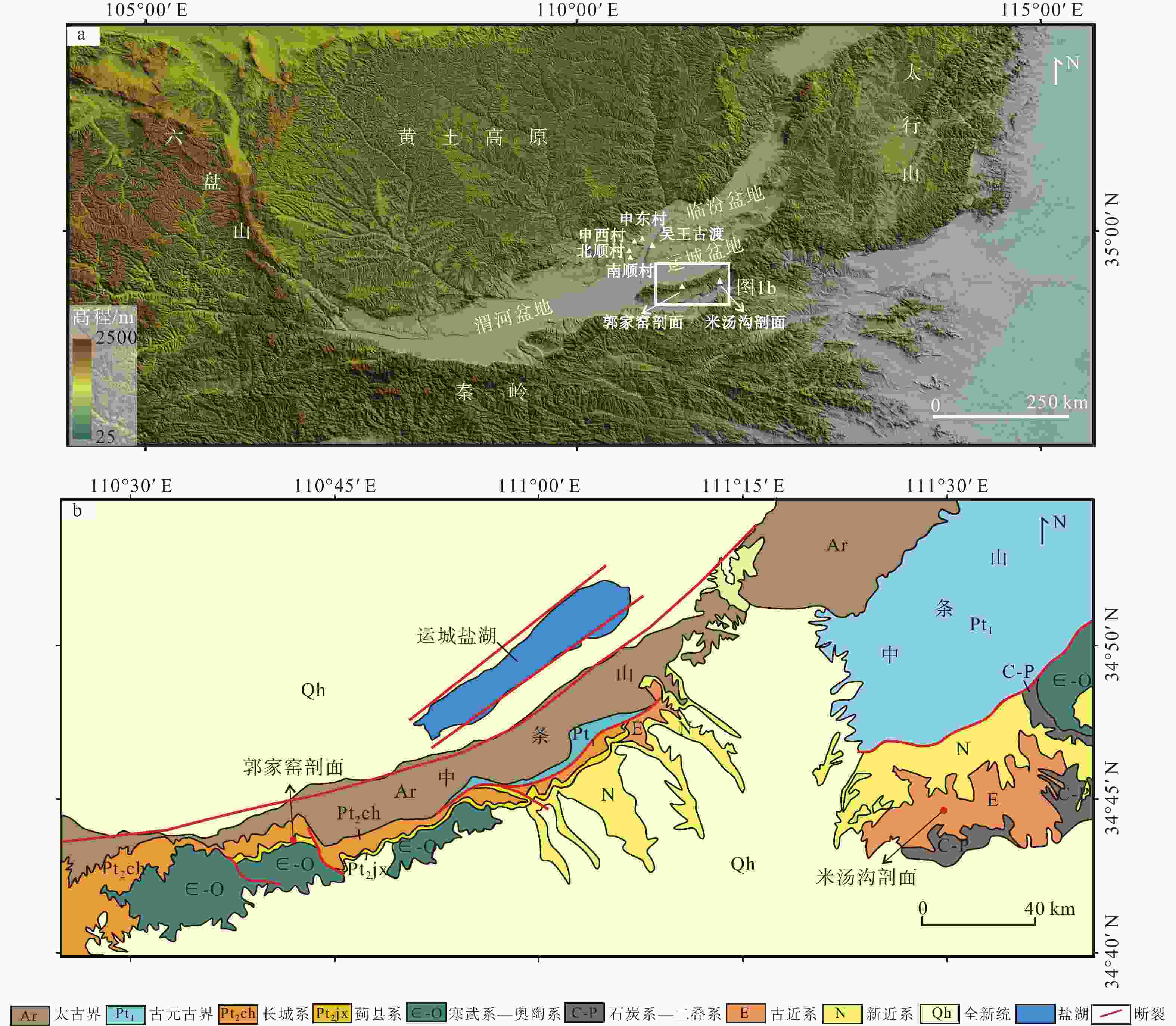
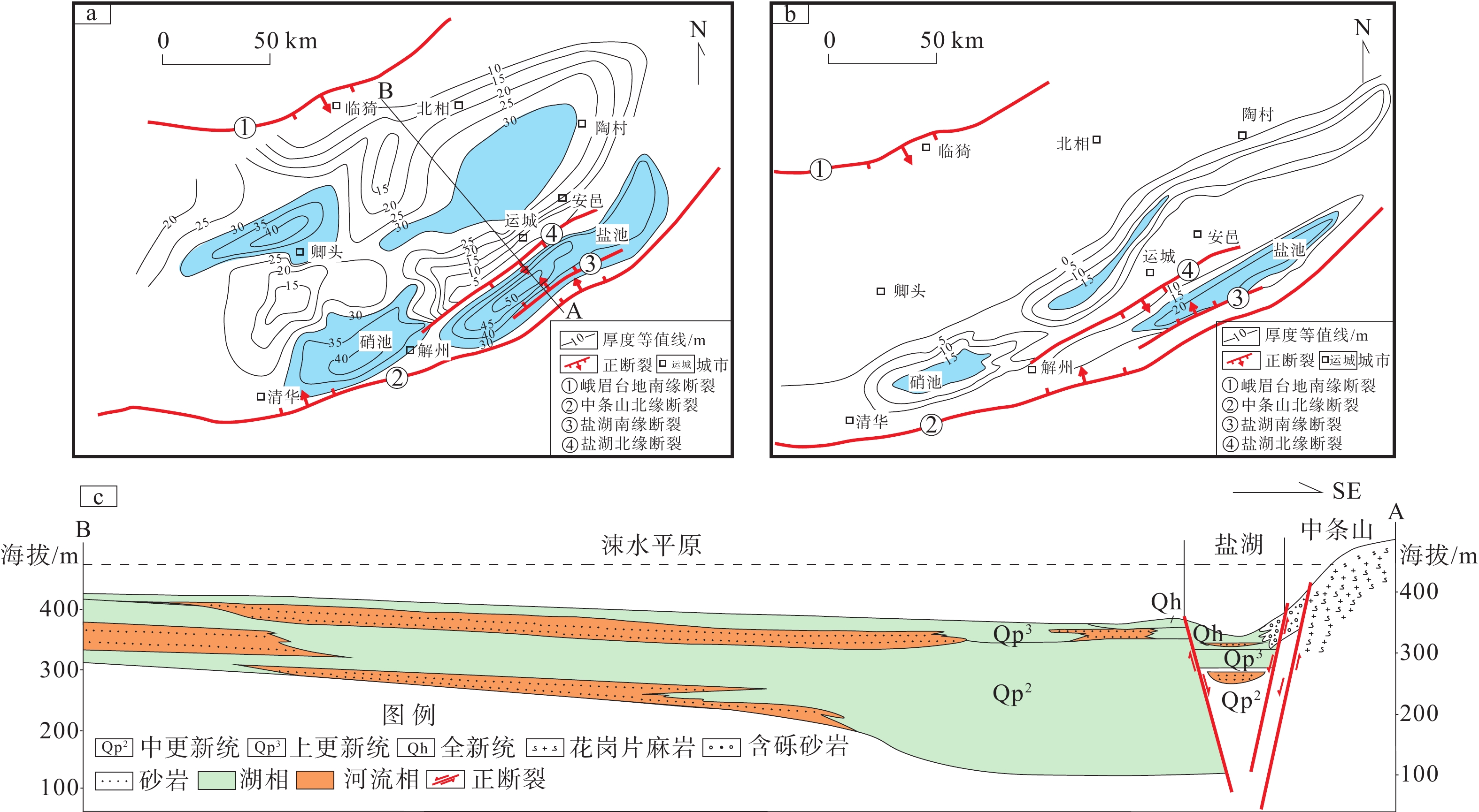
图 1 运城盐湖区域位置及区域地质图
a—盐湖区域位置图;b—盐湖及邻区区域地质图
Figure 1. Regional location and geological map of the Yuncheng Salt Lake
(a) Regional location map of the Yuncheng Salt Lake ; (b) Geological map of the Yuncheng Salt Lake and adjacent areas
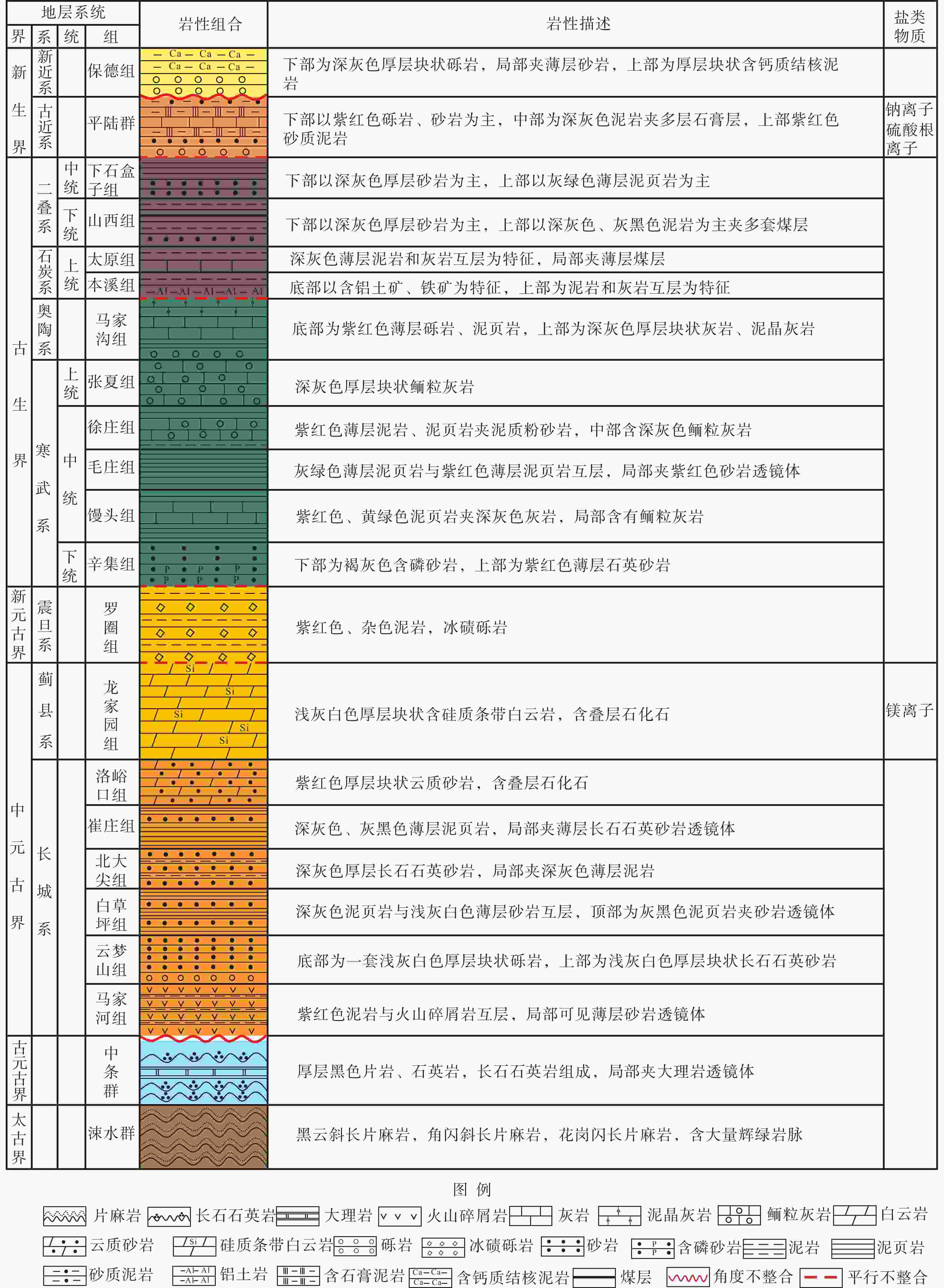
图 2 运城盐湖及邻区地层综合柱状图
Figure 2. Comprehensive histogram of the stratigraphy of the Yuncheng Salt Lake and adjacent areas
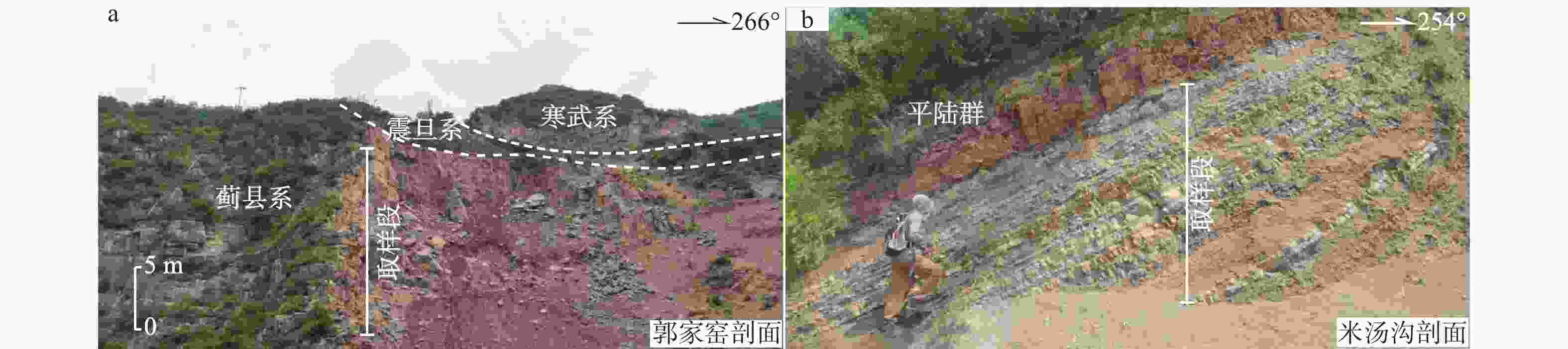
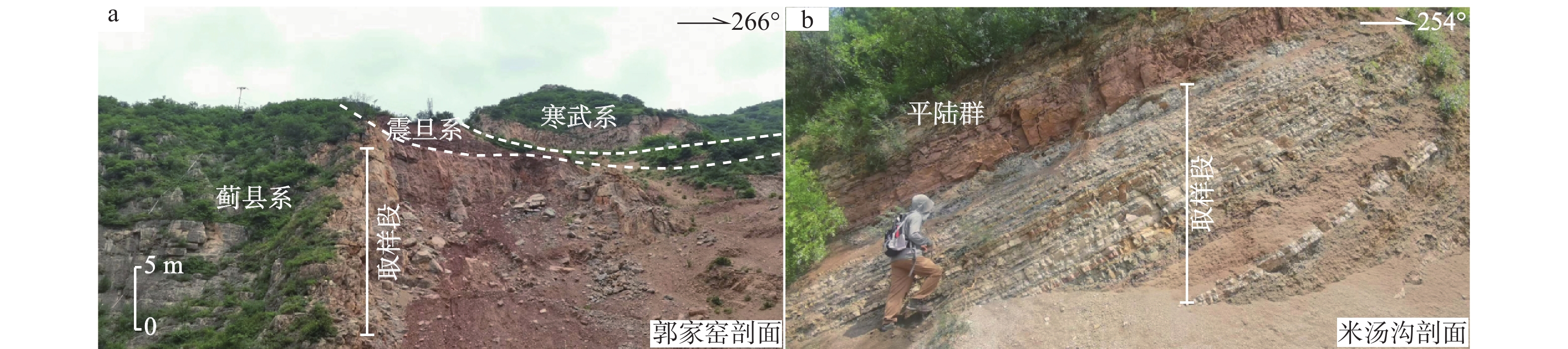
图 3 中条山地区蓟县系和古近系典型露头照片(剖面位置见图1)
a—蓟县系、震旦系和寒武系接触关系; b—古近系平陆群深灰色泥质粉砂岩夹薄层泥灰岩
Figure 3. Representative outcrop photos of Jixian and Paleogene in the Zhongtiao Mountain area (see Figure 1 for section locations)
(a) Contact relationship between the Jixian, Sinian and Cambrian System ; (b) Paleogene Pinglu Group dark gray argillaceous siltstone with thin layers of marlstone
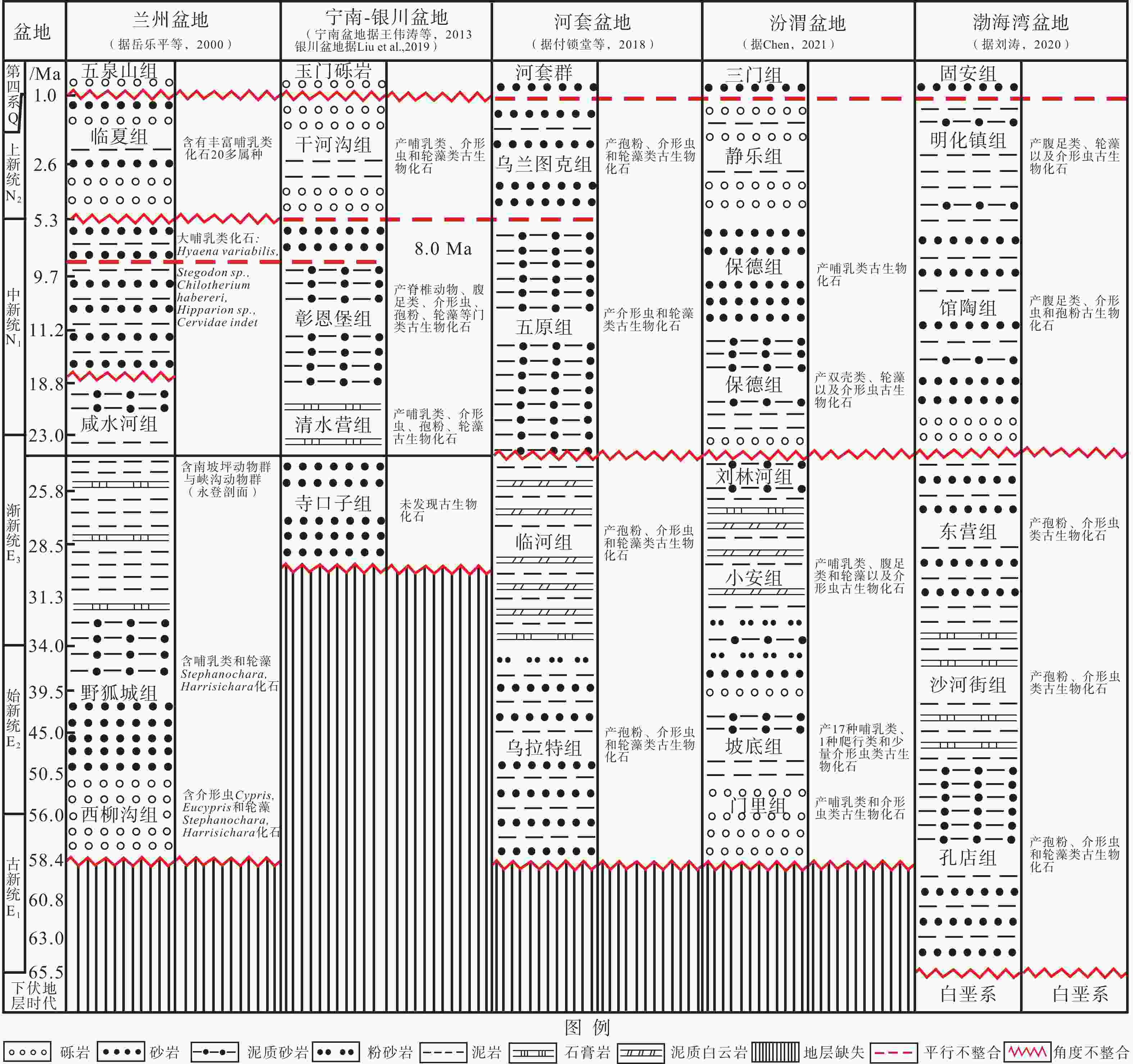
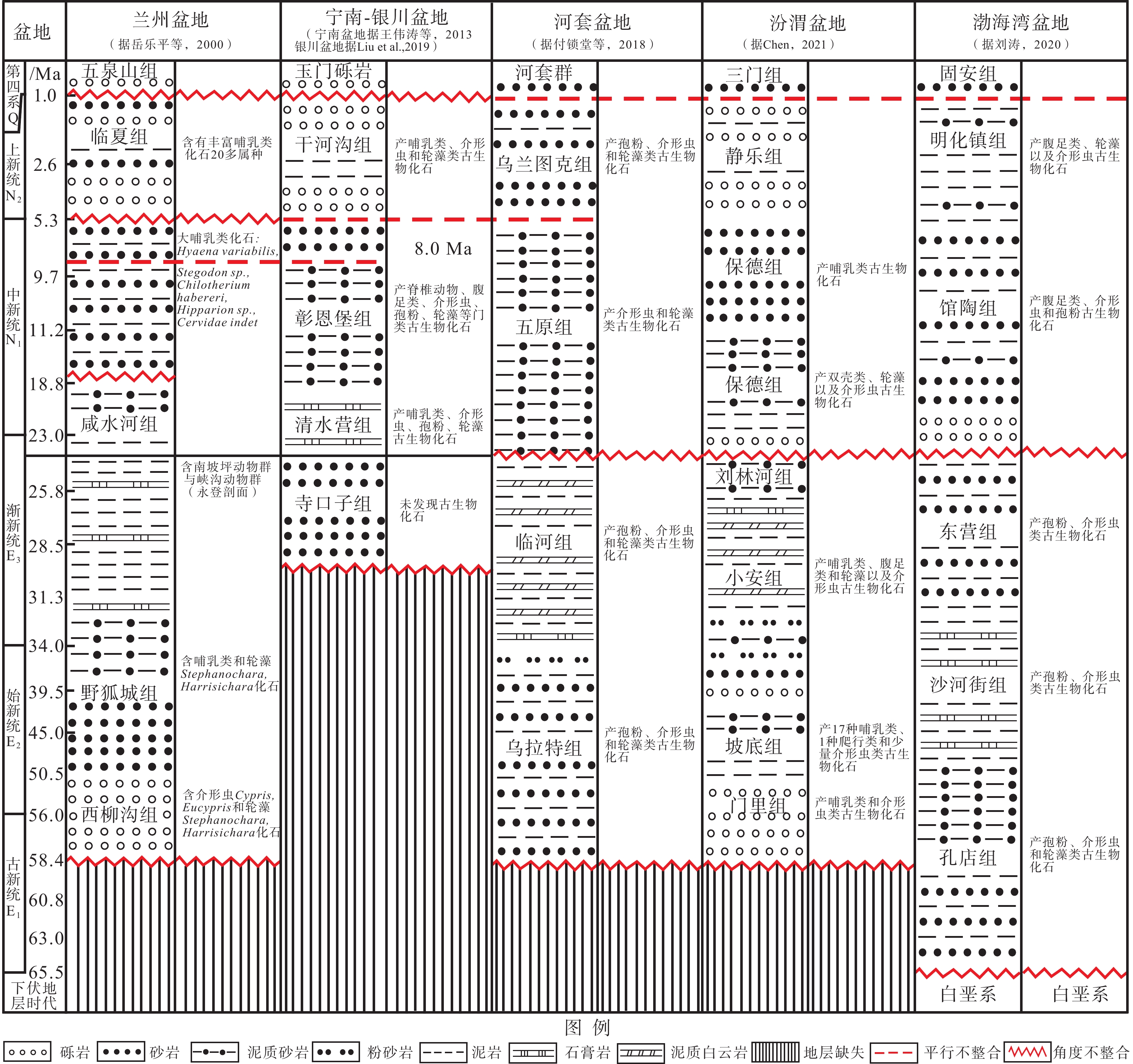
图 4 河西走廊−华北主要新生代盆地地层对比图
Figure 4. Stratigraphic correlation map of the main Cenozoic basins in Hexi Corridor and North China
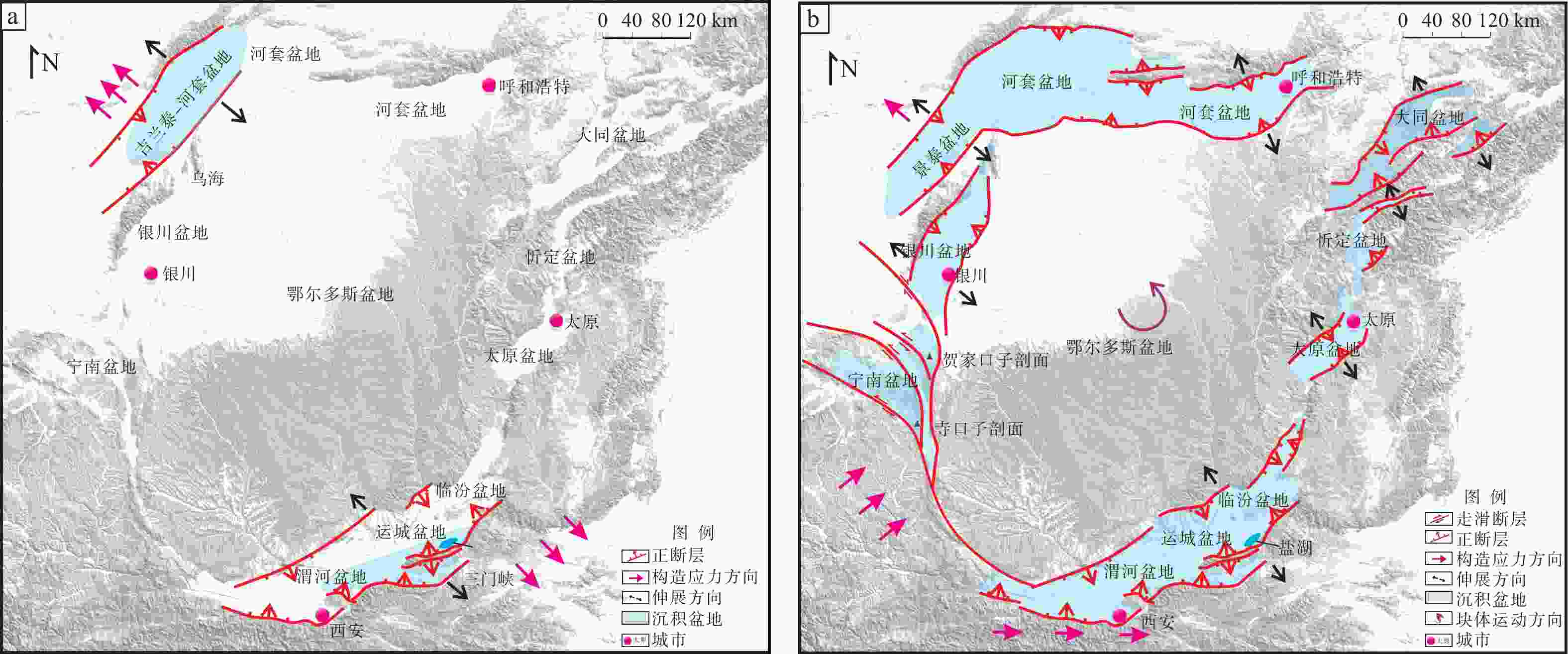
图 5 鄂尔多斯地块周缘古近纪—新近纪区域构造应力场特征
a—古近纪区域构造应力场特征;b—新近纪区域构造应力场特征
Figure 5. Characteristics of regional tectonic stress field around the Ordos Block during the Paleogene-Neogene period
(a) Paleogene period; (b) Neogene period
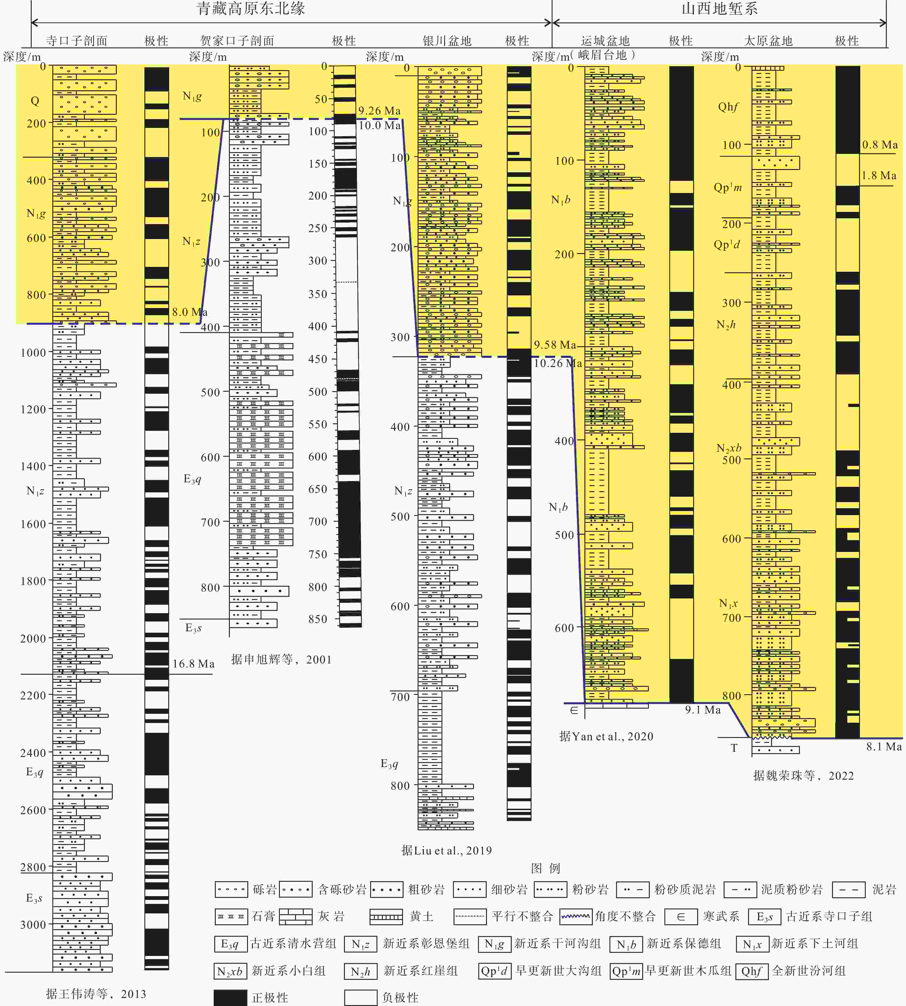
图 6 青藏高原东北缘和山西地堑系新生代地层年代格架对比图(剖面位置见图5)
Figure 6. Cenozoic stratigraphic age framework correlation map of northeastern Qinghai-Tibet Plateau and the Shanxi Graben System (see Figure 5 for section locations)
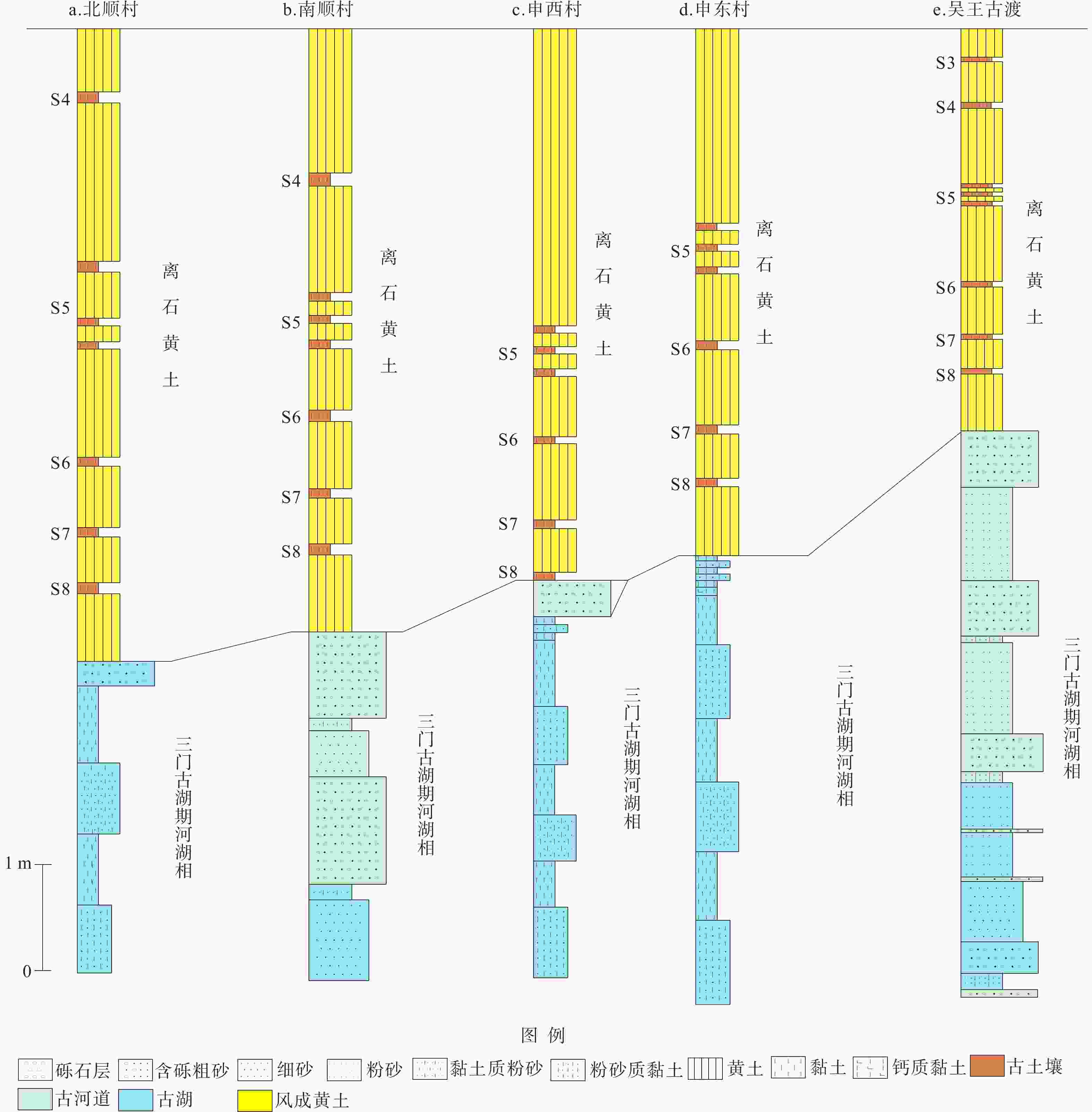
图 7 三门古湖与离石黄土接触关系图(剖面位置见图1a)
Figure 7. Contact relationship diagram between the Sanmen paleolake and Lishi loess (see Figure 1 for section locations)
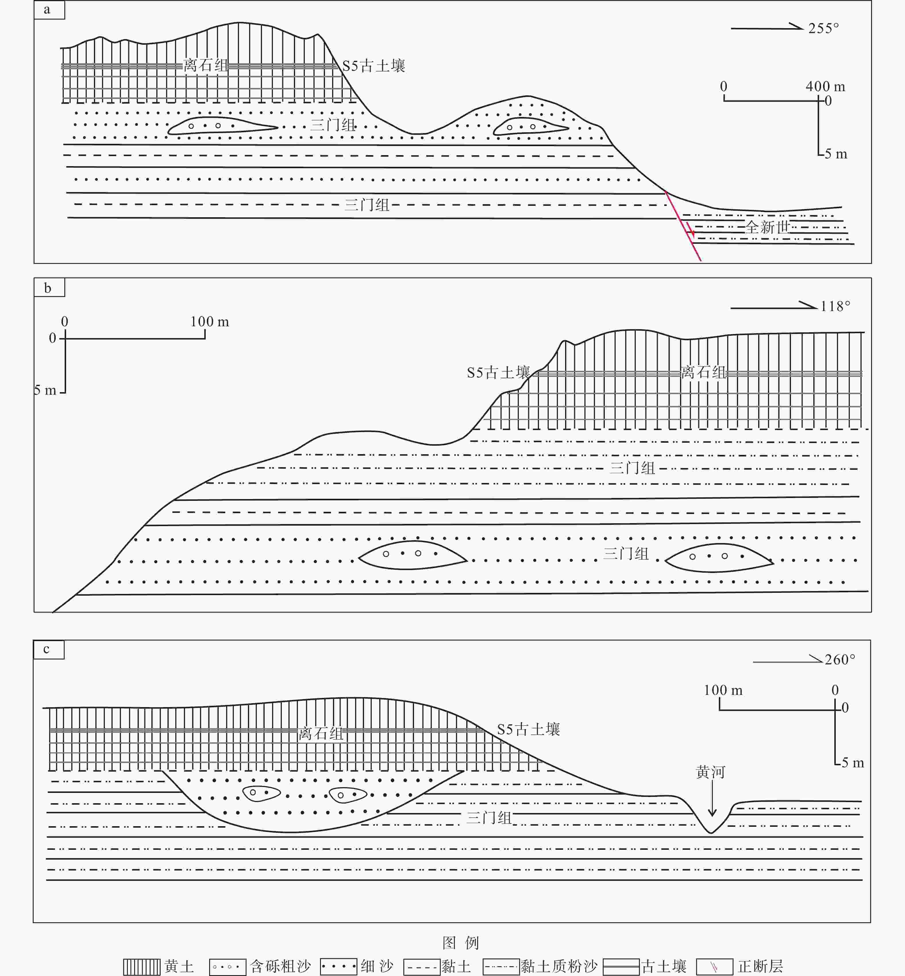
图 8 三门古湖与离石黄土接触关系典型露头素描图(剖面位置见图1)
a—北顺村剖面;b—申东村剖面;c—南顺村剖面
Figure 8. Typical outcrop sketchs of contact relationship between the Sanmen paleolake and Lishi loess (see Figure 1 for section locations)
(a) Beishuncun section; (b) Shendongcun section; (c) Nanshuncun section
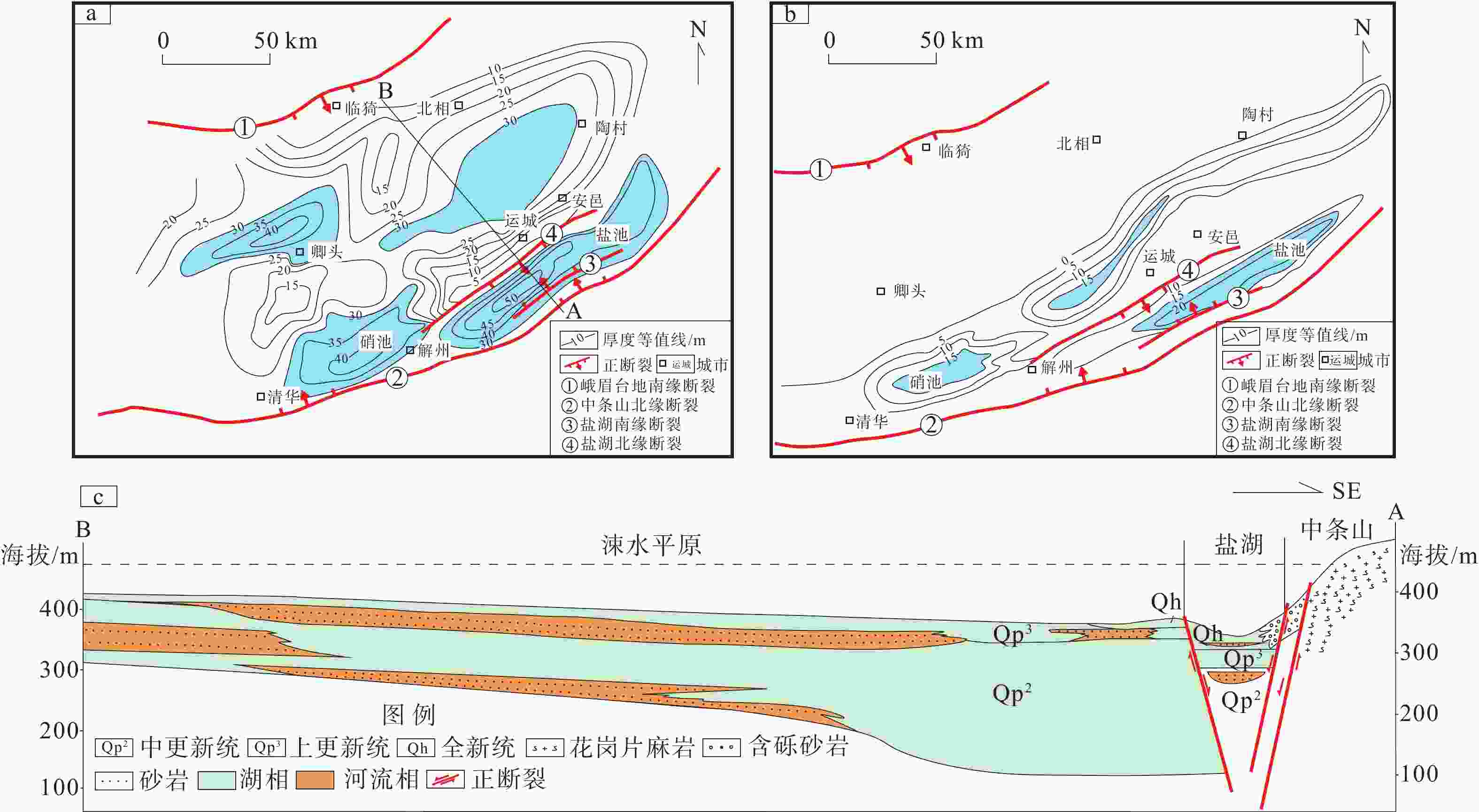
图 9 运城盐湖及邻区晚更新世—全新世地层厚度及地质剖面图
a—运城盐湖及邻区晚更新世地层厚度等值线图;b—运城盐湖及邻区全新世地层厚度等值线图;c—运城盐湖及邻区晚更新世地质剖面图
Figure 9. Late Pleistocene-Holocene stratigraphic thickness and geological profile of the Yuncheng Salt Lake and adjacent areas
(a) Contour map of late Pleistocene stratigraphic thickness of the Yuncheng Salt Lake and adjacent areas; (b) Contour map of Holocene stratigraphic thickness of the Yuncheng Salt Lake and adjacent areas; (c) Late Pleistocene geologic profile of the Yuncheng Salt Lake and adjacent areas
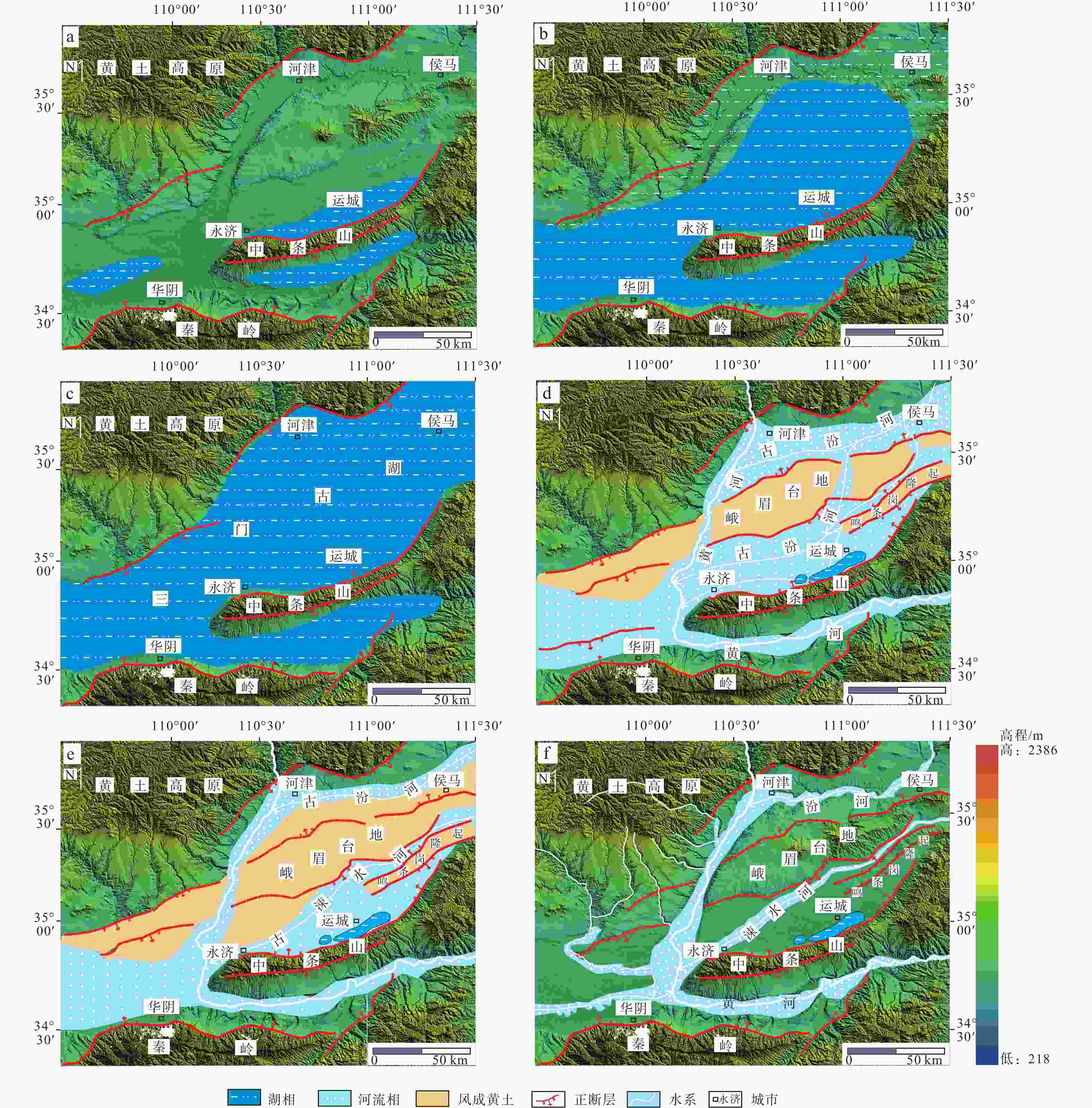
图 10 运城盐湖形成与演化阶段
a—6000~1000万年;b—1000~500万年;c—500~70万年;d—70~7万年;e—7~1万年;f—1万年以来
Figure 10. Formation and evolution stages of the Yuncheng Salt Lake
(a) 60~10 Ma; (b) 10~5 Ma; (c) 5~0.7 Ma; (d) 0.7~0.07 Ma; (e) 0.07~0.01 Ma; (f) after 0.01 Ma
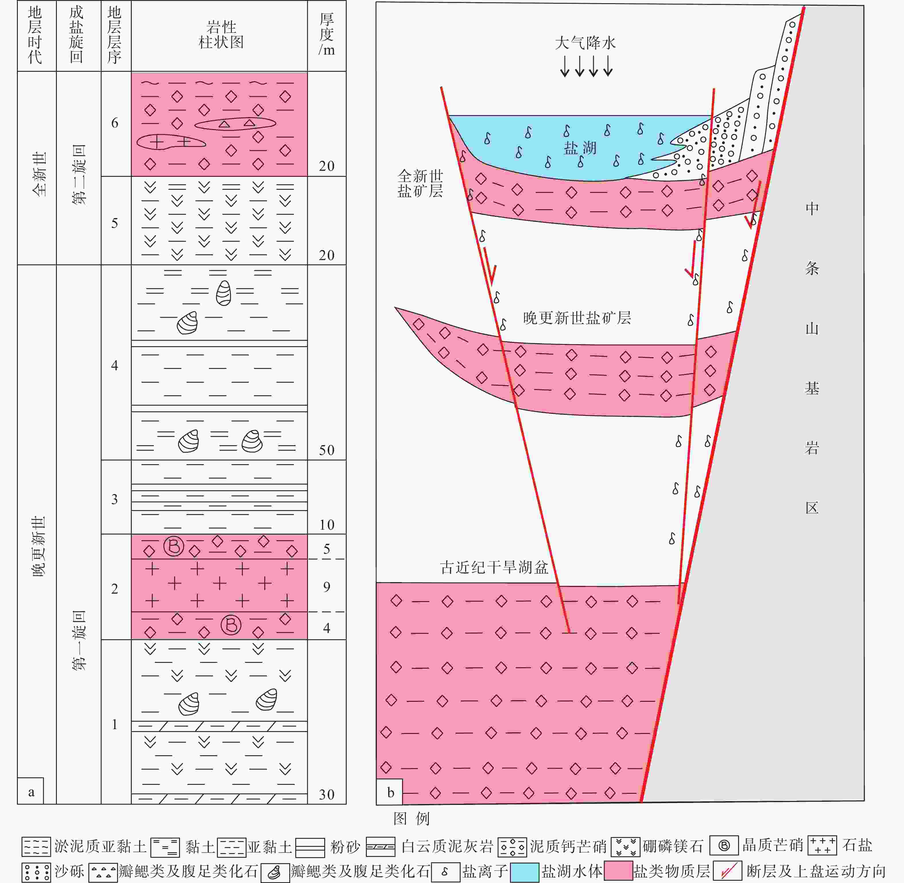
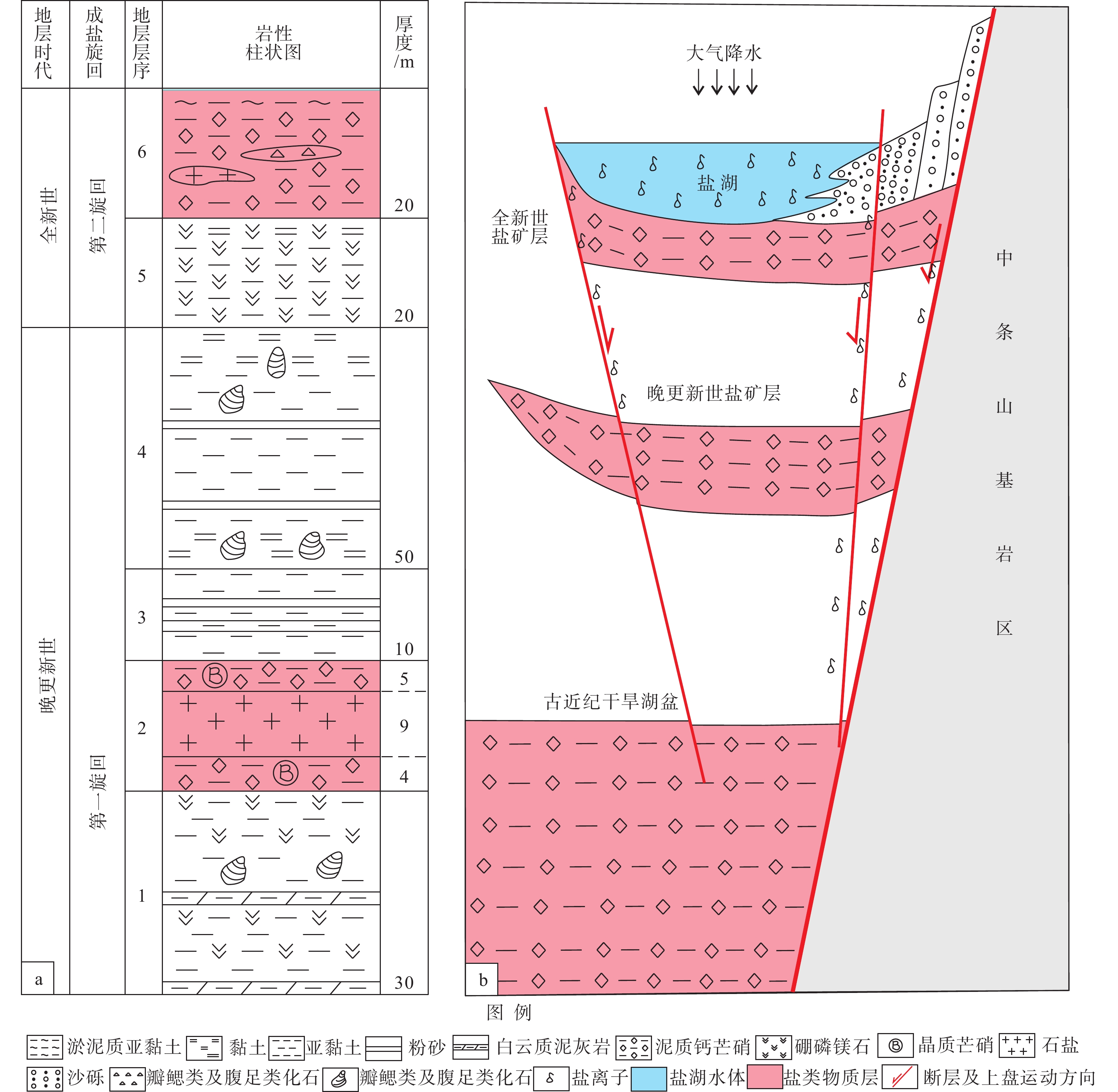
图 11 运城盐湖盐离子运聚模式图
a—运城盐湖晚更新世—全新世地层综合柱状图;b—运城盐湖盐离子运聚模式图
Figure 11. Salt ion migration and accumulation pattern diagram in the Yuncheng Salt Lake
(a) Late Pleistocene-Holocene stratigraphic composite column diagram of the Yuncheng Salt Lake; (b) Salt ion migration and accumulation pattern diagram of the Yuncheng Salt Lake
表 1 中条山郭家窑剖面蓟县系白云岩地球化学元素分析表(%)
Table 1. Geochemical elements analysis of dolomite from the Jixian System in Guojiayao section in the Zhongtiao Mountains (%)
样品编号 岩性 SiO2 Al2O3 TiO2 Fe2O3 FeO CaO MgO K2O Na2O MnO P2O5 H2O+ H2O− SH-1 白云岩 0.08 0.22 0.00 0.03 0.09 30.94 22.38 0.01 0.05 0.01 0.01 0.04 0.20 SH-2 白云岩 4.60 0.10 0.00 0.03 0.08 29.91 21.40 0.01 0.07 0.01 0.00 0.02 0.20 SH-3 白云岩 0.54 0.10 0.00 0.03 0.08 31.30 22.37 0.01 0.03 0.01 0.00 0.00 0.20 SH-4 白云岩 0.04 0.13 0.00 0.01 0.07 31.34 22.37 0.01 0.05 0.01 0.00 0.00 0.30 SH-5 白云岩 6.98 0.11 0.00 0.06 0.08 29.34 20.18 0.01 0.05 0.01 0.00 0.00 0.21 SH-6 白云岩 3.35 0.15 0.00 0.05 0.38 29.82 20.75 0.01 0.04 0.06 0.00 0.02 0.22 SH-7 白云岩 17.28 0.12 0.00 0.08 0.07 26.97 16.88 0.01 0.04 0.01 0.00 0.03 0.20 SH-8 白云岩 4.00 0.08 0.00 0.05 0.07 31.15 20.39 0.00 0.04 0.01 0.00 0.05 0.19 SH-9 白云岩 3.76 0.10 0.00 0.02 0.08 30.12 21.58 0.00 0.03 0.01 0.00 0.00 0.15  下载: 导出CSV
表 2 中条山米汤沟剖面古近系碎屑岩地球化学元素分析表(%)
Table 2. Geochemical elements analysis of Paleogene clastic rocks in Mitanggou section in the Zhongtiao Mountains (%)
样品编号 岩性 SiO2 Al2O3 TiO2 Fe2O3 FeO CaO MgO K2O Na2O MnO P2O5 H2O+ H2O− MTG-1 粉砂岩 52.04 18.61 0.69 5.43 0.50 3.14 3.61 3.30 3.49 0.06 0.14 5.96 4.04 MTG-2 粉砂岩 47.62 18.89 0.68 5.46 0.74 4.07 4.98 3.63 2.94 0.14 0.18 6.56 4.59 MTG-3 粉砂岩 48.90 16.70 0.64 5.29 0.58 6.09 4.37 3.36 2.49 0.11 0.14 6.73 4.98 MTG-4 粉砂岩 46.23 15.29 0.63 5.21 0.64 8.96 4.19 3.16 2.40 0.10 0.15 6.71 5.17 MTG-5 粉砂岩 50.01 17.41 0.65 5.08 0.72 5.81 4.03 3.51 2.68 0.06 0.17 5.78 5.06 MTG-6 粉砂岩 55.69 18.65 0.75 4.48 0.31 2.21 3.33 3.73 2.39 0.02 0.04 6.48 7.55 MTG-7 粉砂岩 51.61 18.06 0.69 5.89 0.62 2.87 4.36 3.43 2.38 0.07 0.13 6.93 6.83 MTG-8 泥灰岩 33.46 11.84 0.47 3.59 0.20 26.31 2.21 2.53 2.33 0.03 0.06 7.30 12.64 MTG-9 粉砂岩 49.82 16.99 0.67 4.82 0.36 5.28 3.13 3.52 2.42 0.04 0.07 7.66 7.82 MTG-10 泥灰岩 14.12 5.71 0.20 1.97 0.56 23.24 15.16 0.98 2.64 0.26 0.14 3.23 2.01
下载: 导出CSV
-
[1] BELLIER O, MERCIER J L, VERGELY P, et al., 1988. Evolution sédimentaire et tectonique du graben cénozoïque de la Wei he (province du Shaanxi, Chine du Nord)[J]. Bulletin de la Société Géologique de France, 4(6): 979-994. [2] BELLIER O, VERGELY P, MERCIER J L, et al., 1991. Analyse tectonique et sédimentaire dans les monts Li Shan (province du Shaanxi, Chine du Nord): datation des régimes tectoniques extensifs dans le graben de la Wei he[J]. Bulletin de la Société Géologique de France, 162(1): 101-112. [3] CHANG D Y, ZHANG C L, CHEN Y P, et al., 2021. Study of sequence stratigraphy of Majiagou Formation in Xunyi area and its periphery, South Ordos Basin[J]. Mineral Resources and Geology, 35(5): 901-908. (in Chinese with English abstract [4] CHEN X Q, DONG S W, SHI W, et al., 2021. Magnetostratigraphic ages of the Cenozoic Weihe and Shanxi Grabens in North China and their tectonic implications[J]. Tectonophysics, 813: 228914. doi: 10.1016/j.tecto.2021.228914 [5] CUI J W, LI Z H, JING X H, et al., 2023. The initial time of the Fen–Wei graben system: constraints from geochronology of the Qifeng granite porphyry dikes in the Zhongtiaoshan Mountains[J]. Journal of Geomechanics, 29(4): 485-496. (in Chinese with English abstract [6] DONG J K, ZHAO Y, CHENG F Q, et al., 2006. Formation and development utilization of Yuncheng salt lake[J]. Journal of Salt Science and Chemical Industry, 35(4): 37-39. (in Chinese with English abstract [7] DONG X P, LI Z H, JING X H, et al., 2023. Stratigraphic sequence characteristics and geochronology research progress of the Cenozoic in the arcuate tectonic belt on the northeastern margin of the Tibet Plateau[J]. Journal of Geomechanics, 29(4): 465-484. (in Chinese with English abstract [8] FAN L G, MENG Q R, WU G L, et al., 2019. Paleogene crustal extension in the eastern segment of the NE Tibetan Plateau[J]. Earth and Planetary Science Letters, 514: 62-74. doi: 10.1016/j.jpgl.2019.02.036 [9] FAN R Y, YANG M M, ZHOU J P, et al., 2023. The spore-pollen assemblages of the Miocene Baode Formation from Borehole ZK301 in the Yuncheng Basin and its geological significance[J]. Journal of Geomechanics, 29(4): 543-554. (in Chinese with English abstract [10] FANG X M, 2017. Phased uplift of the Tibetan Plateau[J]. Science & Technology Review, 35(6): 42-50. (in Chinese with English abstract [11] FENG Y L, ZHOU H M, REN J Y, et al., 2010. Paleogene sequence stratigraphy in the east of the Bohai Bay Basin and its response to structural movement[J]. Scientia Sinica: Terrae, 40(10): 1356-1376. (in Chinese) doi: 10.1360/zd2010-40-10-1356 [12] FU S T, FU J H, YU J, et al,2018. Petroleum geological features and exploration prospect of Linhe Depression in Hetao Basin, China[J]. Petroleum Exploration and Development,45(5):749-762. (in Chinese with English abstract [13] GUO L Z, XUE Y Q, 1958. The pleistocene sediments of the lower reaches of the Fenho and the Sushui: their origin and bearings on the geomorphological evolution of these two rivers[J]. Quaternary Sciences, 1(1): 107-117. (in Chinese) [14] HU J M, YAN J Y, CHENG Y, et al., 2022. Geological records of late Cenozoic tectono-sedimentary-paleoclimatic events in China[J]. Geology and Resources, 31(3): 303-330. (in Chinese with English abstract [15] HU X M, 1997. The change of former fen river on Emei platform[J]. Journal of Anhui Normal University (Natural Science), 20(2): 154-158. (in Chinese with English abstract [16] HU X M, GUO J X, HU X Y, 2010. The development of Morpho-sediment of Quaternary in Fenhe River graben basins and the neotectonic movement[J]. Acta Geographica Sinica, 65(1): 73-81. (in Chinese with English abstract [17] HU X M, CHEN M J, WANG D T, et al., 2012. The sequence difference in the times in the geomorphic-sedimentary evolution in the Fenwei graben basins during the middle-late quaternary and its tectonic significance[J]. Quaternary Sciences, 32(5): 849-858. (in Chinese with English abstract [18] HUANG T, LI Z H, LIU F, et al., 2018. The current situation of desertification in the Hongsibu Basin, Ningxia, and its main geological controlling factors[J]. Journal of Geomechanics, 24(4): 505-514. (in Chinese with English abstract [19] JI Y L, REN H Y, ZHANG S Q, et al., 2022. Paleogene palaeogeography and oil and gas distribution in Bohai Bay Basin[J]. Journal of Palaeogeography (Chinese Edition), 24(4): 611-633. (in Chinese with English abstract [20] JIANG F C, FU J L, WANG S B, et al., 2007. Formation of the Yellow River, inferred from loess-palaeosol sequence in Mangshan and lacustrine sediments in Sanmen Gorge, China[J]. Quaternary International, 175(1): 62-70. doi: 10.1016/j.quaint.2007.03.022 [21] KOU L L, LI Z H, DONG X P, et al., 2021. The age sequence of the detrital zircons from the Guanyindian section in Longde, the northeastern margin of the Tibetan Plateau, and its geological significance[J]. Journal of Geomechanics, 27(6): 1051-1064. (in Chinese with English abstract [22] KOU L L, DONG X P, LI Z H, et al., 2022. Initiation and development of the Late Cenozoic uplift of Daluo Mountains, northeastern margin of the Tibetan Plateau[J]. Acta Geologica Sinica (English Edition), 96(6): 1917-1931. doi: 10.1111/1755-6724.14891 [23] LI C D, ZHAO L G, CHANG Q S, et al., 2017. Zircon U-Pb dating of tuff bed from Luoyukou Formation in western Henan Province on the southern margin of the North China Craton and its stratigraphic attribution discussion[J]. Geology in China, 44(3): 511-525. (in Chinese with English abstract [24] LI G Y, 2008. Research about formation of nitrate mine in Yuncheng salt lake[J]. Shandong Chemical Industry(3): 21-23. (in Chinese with English abstract [25] LI S Z, YU S, ZHAO S J, et al., 2013. Tectonic transition and plate reconstructions of the East Asian Continental Magin[J]. Marine Geology & Quaternary Geology, 33(3): 65-94. (in Chinese with English abstract [26] LI S Z, CAO X Z, WANG G Z, et al., 2019. Meso-Cenozoic tectonic evolution and plate reconstruction of the Pacific Plate[J]. Journal of Geomechanics, 25(5): 642-677. (in Chinese with English abstract [27] LI X, LI J Y, 1998. The research for the characteristics and origin of the salt deposit in Yuncheng salt lake, Shanxi, China[J]. Journal of Xi’an Engineering University, 20(1): 6-9. (in Chinese with English abstract [28] LI Y L, YANG J C, 1994. Environmental evolution of Yuncheng daline lake (Shanxi, China)[J]. Geographical Research, 13(1): 70-74. (in Chinese with English abstract [29] LI Z C, LI W H, LI Y X, et al., 2015. Sedimentary facies of the Cenozoic in Weihe Basin[J]. Journal of Palaeogeography, 17(4): 529-540. (in Chinese with English abstract [30] LIU S D, LI G K, LI Y X, et al., 1988. Discussion on the formation and evolution of the Yellow River from the characteristics of Quaternary sediments in the eastern plain of Henan Province[J]. Henan Geology, 6(2): 20-24. (in Chinese) [31] LIU T., 2020. Sedimentology and Provenance Analysis of Paleogene- Neogene strata in the Eastern Bohai Bay Basin[D]. China University of Geosciences(Beijing). (in Chinese with English abstract [32] LIU X, FAN H R, QIU Z J, et al., 2015. Formation ages of the Jiangxian and Zhongtiao groups in the Zhongtiao Mountain region, North China Craton: insights from SIMS U-Pb dating on zircons of intercalated plagioclase amphibolites[J]. Acta Petrologica Sinica, 31(6): 1564-1572. (in Chinese with English abstract [33] LIU X B, SHI W, HU J M, et al., 2019. Magnetostratigraphy and tectonic implications of Paleogene-Neogene Sediments in the Yinchuan Basin, western North China Craton[J]. Journal of Asian Earth Sciences, 173: 61-69. doi: 10.1016/j.jseaes.2019.01.016 [34] LIU X F, WANG Q F, MA Y, et al., 2020. Provenance of iron, bauxite and clay deposits of the Carboniferous Benxi Formation in southern margin of North China Craton: an example from Da'an bauxite and clay deposit of Sanmenxia area, Henan Province[J]. Journal of Palaeogeography (Chinese Edition), 22(5): 965-976. (in Chinese with English abstract [35] MERCIER J L, VERGELY P, ZHANG Y Q, et al., 2013. Structural records of the Late Cretaceous-Cenozoic extension in Eastern China and the kinematics of the Southern Tan-Lu and Qinling Fault Zone (Anhui and Shaanxi provinces, PR China)[J]. Tectonophysics, 582: 50-75. doi: 10.1016/j.tecto.2012.09.015 [36] NAN D B, LI Z H, DONG X P, et al., 2023. Late Pleistocene stratigraphic sequence and geologic significance of the Kaolao Tableland in the Yuncheng Basin[J]. Journal of Geomechanics, 29(4): 497-511. (in Chinese with English abstract [37] PAN B T, WANG J P, GAO H S, et al., 2005. Paleomagnetic dating of the topmost terrace in Kouma, Henan and its indication to the Yellow River’s running through Sanmen Gorges[J]. Chinese Science Bulletin, 50(7): 657-664. doi: 10.1360/03wd0290 [38] SHANG Y, PRINS M A, BEETS C J, et al., 2018. Aeolian dust supply from the Yellow River floodplain to the Pleistocene loess deposits of the Mangshan Plateau, central China: evidence from zircon U-Pb age spectra[J]. Quaternary Science Reviews, 182: 131-143. doi: 10.1016/j.quascirev.2018.01.001 [39] SHEN X H, TIAN Q J, DING G Y, et al., 2001. The late Cenozoic stratigraphic sequence and its implication to tectonic evolution, Hejiakouzi Area, Ningxia Hui autonomous region[J]. Earthquake Research in China, 17(2): 156-166. (in Chinese with English abstract [40] SHI W, DONG S W, LIU Y, et al., 2015. Cenozoic tectonic evolution of the South Ningxia region, northeastern Tibetan Plateau inferred from new structural investigations and fault kinematic analyses[J]. Tectonophysics, 649: 139-164. doi: 10.1016/j.tecto.2015.02.024 [41] SHI W, DONG S W, HU J M, 2020. Neotectonics around the Ordos Block, North China: a review and new insights[J]. Earth-Science Reviews, 200: 102969. doi: 10.1016/j.earscirev.2019.102969 [42] SU P, HE H L, TAN X B, et al., 2021. Initiation and evolution of the Shanxi rift system in North China: evidence from low-temperature thermochronology in a plate reconstruction framework[J]. Tectonics, 40(3): e2020TC006298. doi: 10.1029/2020TC006298 [43] SU W B, LI H K, XU L, et al., 2012. Luoyu and Ruyang group at the South Margin of the North China Craton (NCC) should belong in the mesoproterozoic Changchengian system: direct constraints from the LA-MC-ICPMS U-Pb age of the tuffite in the Luoyukou Formation, Ruzhou, Henan, China[J]. Geological Survey and Research, 35(2): 96-108. (in Chinese with English abstract [44] SUN D Z, LI H M, LIN Y X, et al. , 1991. Precambrian geochronology, chronotectonic framework and model of chronocrustal structure of the Zhongtiao Mountains[J]. Acta Geologica Sinica(3): 216-231. (in Chinese with English abstract [45] SUN P X, 2007. The exploitation and utilization of Yuncheng salt lake resources[J]. Journal of Salt Lake Research, 15(2): 38-41, 49. (in Chinese with English abstract [46] SUO Y H, LI S Z, DAI L M, et al., 2012. Cenozoic tectonic migration and basin evolution in East Asia and its continental margins[J]. Acta Petrologica Sinica, 28(8): 2602-2618. (in Chinese with English abstract [47] SUO Y H, LI S Z, CAO X Z, et al., 2017. Mesozoic- Cenzoic inversion tectonics of East China and its implications for the subduction process of the oceanic plate[J]. Earth Science Frontiers, 2017, 24(4): 249-267. (in Chinese with English abstract [48] TAO M H, ZHAO L M, TAO L, 2005. The important inflections of the geological process in the carboniferous and Permian systems of the Pan-North China region[J]. Journal of Stratigraphy, 29(S1): 534-540. (in Chinese with English abstract [49] WANG F, LIU X S, ZHAO W B, et al., 2023. Detrital zircon U-Pb geochronology characteristics of Permian sandstone and its constraints on the tectonic evolution of the southern Ordos Basin[J]. Acta Sedimentologica Sinica, 41(5): 1396-1413. (in Chinese with English abstract [50] WANG Q, LI C G, TIAN G Q, et al., 2002. Tremendous change of the earth surface system and tectonic setting of salt-lake formation in Yuncheng Basin since 7.1 Ma[J]. Science in China Series D: Earth Sciences, 45(2): 110-122. doi: 10.1007/BF02879788 [51] WANG S B, JIANG F C, WU X H, et al., 2004. The connotation and significance of sanmen Formation[J]. Quaternary Sciences, 24(1): 116-123. (in Chinese with English abstract [52] WANG W T, ZHENG D W, PANG J Z, 2013. Provenancial tracing for the Cenozoic Sikouzi section in the northeastern margin of the Tibetan Plateau and its tectonic Implications[J]. Acta Geologica Sinica, 87(10): 1551-1569. (in Chinese with English abstract [53] WANG Y R, LI Y L, YAN D D, et al., 2015. Holocene paleoseismology of the middle and south segments of the north Zhongtiaoshan fault zone, Shanxi[J]. Seismology and Geology, 37(1): 1-12. (in Chinese with English abstract [54] WEI R Z, ZHUANG Q T, YAN J Y, et al., 2022. Late Cenozoic stratigraphic division and sedimentary environment of Jinzhong Basin in Shanxi Province, with the climate and lake evolution since the pre-Qin period (2500 years ago)[J]. Geology in China, 49(3): 912-928. (in Chinese with English abstract [55] WU F, LI Z H, JlNG X H, et al.,2024. Detrital zircon ages of the Permian coal-bearing rock series in the ZhongtiaoMountain area and their sedimentological constraints on regional tectonic activity[J]. Coal Geology & Exploration,52(11):37-54. [56] WU X H, JIANG F C, WANG S M, et al., 1998. On problem of the Yellow River passing through the Sanmen Gorge and flowing east into sea[J]. Quaternary Sciences, 18(2): 188. (in Chinese with English abstract [57] XIAO F, WANG J G, WU H Y, et al. , 2017. Cambrian sequence stratigraphic framework in the middle-northern North China[J]. Acta Petrolei Sinica, 38(10): 1144-1157, 1167. (in Chinese with English abstract [58] XING Z Y, ZHAO B, TU M Y, et al., 2005. The formation of the Fenwei rift valley[J]. Earth Science Frontiers, 12(2): 247-262. (in Chinese with English abstract [59] XU X W, MA X Y, DENG Q D, 1993. Neotectonic activity along the Shanxi rift system, China[J]. Tectonophysics, 219(4): 305-325. doi: 10.1016/0040-1951(93)90180-R [60] XUE D, 1996. A humble opinion of the formed age for the eastern section of the Yellow River[J]. Henan Geology, 14(2): 110-112. (in Chinese with English abstract [61] YAN J Y, HU J M, GONG W B, et al., 2020. Late Cenozoic magnetostratigraphy of the Yuncheng Basin, central North China Craton and its tectonic implications[J]. Geological Journal, 55(11): 7415-7428. doi: 10.1002/gj.3744 [62] YAN J Y, HU J M, WANG D M, et al., 2021. The critical geological events in the Huang-Huai-Hai Plain during the Late Cenozoic[J]. Geological Bulletin of China, 40(5): 623-648. (in Chinese with English abstract [63] YANG J, LI D M, CHANG J, et al., 2019. Analysis of geochemical characteristic of hot spring water of Xiaxian Seismic Station of Shanxi[J]. Seismological and Geomagnetic Observation and Research, 40(4): 114-119. (in Chinese with English abstract [64] YANG S Y, CAI J G, LI C X, et al., 2001. New discussion about the run-through time of the Yellow River[J]. Marine Geology & Quaternary Geology, 21(2): 15-20. (in Chinese with English abstract [65] YUE L P, Heller F, QIU Z X, et al,2000. Paleomagnetic and geological age dating of the Tertiary strata and paleoenvironmental record in the Lanzhou Basin[J]. Science Bulletin,(18):1998-2003. (in Chinese) [66] ZHANG K, 1991. Tilloid at the bottom of the sedimentary covers on the margins of the Ordos basin[J]. Regional Geology of China(1): 79-85. (in Chinese with English abstract [67] ZHANG L, LIU J Q, QIN X G, 2018. The environmental effects and mechanism of the Yellow River flooding into the Huaibei Plain during Quaternary: a brief review[J]. Quaternary Sciences, 38(2): 441-453. (in Chinese with English abstract [68] ZHANG Y C, HE C B, 2004. Main mineral resources in Yun Cheng-Yanhu and their comprehensive utilization[J]. Mining Engineering, 2(6): 23-25. (in Chinese) [69] ZHANG Y Q, MERCIER J L, VERGÉLY P, 1998. Extension in the graben systems around the Ordos (China), and its contribution to the extrusion tectonics of south China with respect to Gobi-Mongolia[J]. Tectonophysics, 285(1-2): 41-75. doi: 10.1016/S0040-1951(97)00170-4 [70] ZHAO B, WANG D H, HOU K J, et al., 2012. Isochronology study on Sushui complex in Zhongtiao Mountains and its geological significance[J]. Journal of Earth Sciences and Environment, 34(1): 1-8. (in Chinese with English abstract [71] ZHU G Y, LI X, 2023. Progress in genetic types and research methods of dolomite[J]. Acta Petrolei Sinica, 44(7): 1167-1190. (in Chinese with English abstract [72] ZHU X D, 1996. Dingcun 54: 100 location: environmental catastrophic events and epochal significance of mussel fossils[J]. Journal of Chinese Antiquity(4): 36-38. (in Chinese) [73] 常大宇,张成龙,陈燕萍,等,2021. 鄂尔多斯盆地南部旬宜地区及周缘马家沟组层序地层研究[J]. 矿产与地质,35(5):901-908. [74] 崔加伟,李振宏,井向辉,等,2023. 汾渭地堑系开启时限:基于中条山奇峰花岗斑岩岩脉的年代学约束[J]. 地质力学学报,29(4):485-496. [75] 董江凯,赵毅,程芳琴,等,2006. 运城盐湖的形成及其开发利用[J]. 盐业与化工,35(4):37-39. [76] 董晓朋,李振宏,井向辉,等,2023. 青藏高原东北缘弧形构造带新生代地层沉积序列及年代学研究进展[J]. 地质力学学报,29(4):465-484. [77] 樊如意,杨萌萌,周均朋,等,2023. 运城盆地ZK301钻孔中新世保德组孢粉组合及地质意义[J]. 地质力学学报,29(4):543-554. [78] 方小敏,2017. 青藏高原隆升阶段性[J]. 科技导报,35(6):42-50. [79] 冯有良,周海民,任建业,等,2010. 渤海湾盆地东部古近系层序地层及其对构造活动的响应[J]. 中国科学:地球科学,40(10):1356-1376. [80] 付锁堂,付金华,喻建,等,2018. 河套盆地临河坳陷石油地质特征及勘探前景[J]. 石油勘探与开发,45(5):749-762. [81] 郭令智,薛禹群,1958. 从第四纪沉积物讨论山西汾河与涑水在地貌演化上的关系[J]. 第四纪研究,1(1):107-117. [82] 胡健民,闫纪元,程瑜,等,2022. 中国晚新生代构造−沉积−古气候事件的地质记录[J]. 地质与资源,31(3):303-330. [83] 胡晓猛,1997. 古汾河在峨嵋台地上的变迁[J]. 安徽师大学报(自然科学版),20(2):154-158. [84] 胡小猛,郭家秀,胡向阳,2010. 汾河地堑湖盆第四纪地貌−沉积特征的构造控制[J]. 地理学报,65(1):73-81. [85] 胡小猛,陈美君,王杜涛,等,2012. 汾渭地堑系列湖盆第四纪中晚期地貌与沉积阶段性演化的时间序次差异及其构造指示意义[J]. 第四纪研究,32(5):849-858. [86] 黄婷,李振宏,刘锋,等,2018. 宁夏红寺堡盆地地表沙漠化现状及其地质主控因素[J]. 地质力学学报,24(4):505-514. [87] 纪友亮,任红燕,张世奇,等,2022. 渤海湾盆地古近纪古地理特征与油气[J]. 古地理学报,24(4):611-633. [88] 寇琳琳,李振宏,董晓朋,等,2021. 青藏高原东北缘隆德观音店剖面碎屑锆石年龄序列及地质意义[J]. 地质力学学报,27(6):1051-1064. [89] 李承东,赵利刚,常青松,等,2017. 豫西洛峪口组凝灰岩锆石LA-MC-ICPMS U-Pb年龄及地层归属讨论[J]. 中国地质,44(3):511-525. [90] 李国英,2008. 运城盐湖矿硝成因探讨[J]. 山东化工(3):21-23. [91] 李三忠,余珊,赵淑娟,等,2013. 东亚大陆边缘的板块重建与构造转换[J]. 海洋地质与第四纪地质,33(3):65-94. [92] 李三忠,曹现志,王光增,等,2019. 太平洋板块中—新生代构造演化及板块重建[J]. 地质力学学报,25(5):642-677. [93] 李侠,李晶莹,1998. 运城盐湖盐类矿床特征及其成因探讨[J]. 西安工程学院学报,20(1):6-9. [94] 李有利,杨景春,1994. 运城盐湖沉积环境演化[J]. 地理研究,13(1):70-74. [95] 李智超,李文厚,李永项,等,2015. 渭河盆地新生代沉积相研究[J]. 古地理学报,17(4):529-540. [96] 刘书丹,李广坤,李玉信,等,1988. 从河南东部平原第四纪沉积物特征探讨黄河的形成与演变[J]. 河南地质,6(2):20-24. [97] 刘涛,2020. 渤海湾盆地东部古近系—新近系沉积与物源特征研究[D].中国地质大学(北京). [98] 刘玄,范宏瑞,邱正杰,等,2015. 中条山地区绛县群和中条群沉积时限:夹层斜长角闪岩 SIMS锆石U-Pb年代学证据[J]. 岩石学报,31(6):1564-1572. [99] 刘学飞,王庆飞,马遥,等,2020. 华北克拉通南缘石炭系本溪组铁−铝黏土矿物质来源:以河南三门峡大安铝黏土矿床为例[J]. 古地理学报,22(5):965-976. [100] 南德斌,李振宏,董晓朋,等,2023. 运城盆地栲栳塬晚更新世地层序列及地质意义[J]. 地质力学学报,29(4):497-511. [101] 潘保田,王均平,高红山,等,2005. 河南扣马黄河最高级阶地古地磁年代及其对黄河贯通时代的指示[J]. 科学通报,50(3):255-261. [102] 申旭辉,田勤俭,丁国瑜,等,2001. 宁夏贺家口子地区晚新生代地层序列及其构造意义[J]. 中国地震,17(2):156-166. [103] 苏文博,李怀坤,徐莉,等,2012. 华北克拉通南缘洛峪群−汝阳群属于中元古界长城系:河南汝州洛峪口组层凝灰岩锆石LA-MC-ICPMS U-Pb年龄的直接约束[J]. 地质调查与研究,35(2):96-108. [104] 孙大中,李惠民,林源贤,等,1991. 中条山前寒武纪年代学、年代构造格架和年代地壳结构模式的研究[J]. 地质学报(3):216-231. [105] 孙培霞,2007. 运城盐湖资源及开发利用情况[J]. 盐湖研究,15(2):38-41,49. [106] 索艳慧,李三忠,戴黎明,等,2012. 东亚及其大陆边缘新生代构造迁移与盆地演化[J]. 岩石学报,28(8):2602-2618. [107] 索艳慧,李三忠,曹现志,等,2017. 中国东部中新生代反转构造及其记录的大洋板块俯冲过程[J]. 地学前缘,24(4):249-267. [108] 陶明华,赵力民,陶亮,2005. 泛华北区石炭系、二叠系内部的重要地质演化转折[J]. 地层学杂志,29(S1):534-540. [109] 王峰,刘新社,赵伟波,等,2023. 鄂尔多斯盆地南部二叠系砂岩碎屑锆石年代学特征及地质意义[J]. 沉积学报,41(5):1396-1413. [110] 王强,李彩光,田国强,等,2000. 7.1Ma以来运城盆地地表系统巨变及盐湖形成的构造背景[J]. 中国科学(D辑),30(4):420-428. [111] 王书兵,蒋复初,吴锡浩,等,2004. 三门组的内涵及其意义[J]. 第四纪研究,24(1):116-123. [112] 王伟涛,郑德文,庞建章,2013. 青藏高原东北缘寺口子剖面碎屑锆石示踪及其构造意义[J]. 地质学报,87(10):1551-1569. [113] 王怡然,李有利,闫冬冬,等,2015. 中条山北麓断裂中南段全新世地震事件的初步研究[J]. 地震地质,37(1):1-12. [114] 魏荣珠,庄其天,闫纪元,等,2022. 山西晋中盆地晚新生代地层划分、沉积环境及其先秦以来气候和湖泊演化[J]. 中国地质,49(3):912-928. [115] 吴芳,李振宏,井向辉,等,2024. 中条山地区二叠系含煤岩系碎屑锆石年龄及其对区域构造活动的沉积学制约[J]. 煤田地质与勘探,52(11):37-54. [116] 吴锡浩,蒋复初,王苏民,等,1998. 关于黄河贯通三门峡东流入海问题[J]. 第四纪研究,(2):188. [117] 肖飞,汪建国,吴和源,等,2017. 华北地区中北部寒武系层序地层格架[J]. 石油学报,38(10):1144-1157,1167. doi: 10.7623/syxb201710005 [118] 邢作云,赵斌,涂美义,等,2005. 汾渭裂谷系与造山带耦合关系及其形成机制研究[J]. 地学前缘,12(2):247-262. [119] 薛铎,1996. 黄河东段形成时代管见[J]. 河南地质,14(2):110-112. [120] 闫纪元,胡健民,王东明,等,2021. 黄淮海平原晚新生代重大地质事件[J]. 地质通报,40(5):623-648. [121] 杨静,李冬梅,常姣,等,2019. 山西夏县中心地震台温泉水化学特征[J]. 地震地磁观测与研究,40(4):114-119. [122] 杨守业,蔡进功,李从先,等,2001. 黄河贯通时间的新探索[J]. 海洋地质与第四纪地质,21(2):15-20. [123] 岳乐平,Heller F,邱占祥,等,2000. 兰州盆地第三系磁性地层年代与古环境记录[J]. 科学通报,(18):1998-2003. [124] 张抗,1991. 鄂尔多斯盆地边缘沉积盖层底部类冰碛岩的讨论[J]. 中国区域地质(1):79-85. [125] 张磊,刘嘉麒,秦小光,2018. 第四纪黄河入淮成因机制与环境效应的研究现状及存在问题[J]. 第四纪研究,38(2):441-453. doi: 10.11928/j.issn.1001-7410.2018.02.15 [126] 张永朝,贺春宝,2004. 运城盐湖主要资源及综合利用[J]. 矿业工程,2(6):23-25. doi: 10.3969/j.issn.1671-8550.2004.06.009 [127] 赵斌,王登红,侯可军,等,2012. 中条山涑水杂岩的同位素年代学研究及其地质意义[J]. 地球科学与环境学报,34(1):1-8. doi: 10.3969/j.issn.1672-6561.2012.01.001 [128] 朱光有,李茜,2023. 白云岩成因类型与研究方法进展[J]. 石油学报,44(7):1167-1190. doi: 10.7623/syxb202307012 [129] 朱晓东,1996. 丁村54∶100地点蚌类化石的环境灾变事件及时代意义[J]. 文物季刊(4):36-38. -

 下载:
下载:


计量
- 文章访问数: 2146
- HTML全文浏览量: 507
- PDF下载量: 133
- 被引次数: 0
