

Spatial structure characteristics and formation mechanism of the ancient Deda landslide elucidated using the microtremor survey method in Sichuan Province, China
-
摘要: 青藏高原东部地形地貌和地质构造极为复杂,位于该区金沙江流域等高山峡谷区的大型古滑坡具有发育密度大、空间结构复杂等特点,由古滑坡蠕滑变形及复活引起的灾害危害性强。德达古滑坡是位于四川省巴塘县德达乡的一个大型古滑坡,受查龙−然布断裂活动影响,德达古滑坡空间结构特征复杂,滑坡前缘呈现局部复活变形。文章采用遥感解译、现场调查、微动探测和工程地质钻探等工作手段,查明了德达古滑坡的空间结构特征。研究表明,德达古滑坡在平面上分为德达I号滑坡体(I)、德达II号滑坡体(II)和德达古滑坡后壁(Ⅲ)3个部分。通过微动探测结合钻探验证,提出了浅层滑带和深层滑带的微动横波速度划分方案,方案对滑带深度识别相对误差一般为2.6%~4.8%。研究揭示德达I号滑坡体发育2层滑带,浅层滑带S1-1埋深为18.7~20.1 m,深层滑带S1-2埋深为36.2~49.9 m,滑体体积约8.7×10⁶~12.0×10⁶ m3;德达Ⅱ号滑坡体发育1层滑带S2,滑带埋深为25.2~38.6 m,滑体体积约6.3×10⁶~9.6×10⁶ m3。综合分析认为,德达古滑坡是在断裂活动、降雨入渗、河流侵蚀等多种因素作用下形成的,复杂的滑体结构及其成因是滑坡体处于蠕滑变形的主要控制因素。文章研究方法和取得的认识可以为青藏高原东部大型古滑坡空间结构判识和风险防控提供参考。Abstract:
Objective The topography and geological structure of the eastern Qinghai-Tibet Plateau are highly complex. High development density and intricate spatial structures of large ancient landslides in alpine canyon areas, such as those in the Jinsha River, contribute to this complexity. In addition, hazards resulting from creep deformation and the resurgence of these ancient landslides are severe. The ancient Deda landslide, situated in Deda Township, Batang County, Sichuan Province, is a significant ancient landslide influenced by the Chalong-Ranbu fault activity. The spatial structural characteristics of this ancient landslide are complex, with localized resurgence deformation at the landslide front. Methods Various methods were included in the current study, such as remote sensing interpretation, on-site investigations, the microtremor survey method (MSM), and engineering geological drilling to elucidate further the spatial structural characteristics of the ancient Deda landslide. Results The research revealed that the ancient Deda landslide can be divided into three sections in the plan view: the Deda I landslide (I), the Deda II landslide (II), and the rear wall of the ancient Deda landslide (Ⅲ). Using MSM combined with drilling verification, a scheme for classifying the shear wave velocities of shallow and deep sliding zones was constructed, with a relative error in sliding zone depth identification ranging 2.6% ~ 4.8%. This paper showed that the Deda I landslide features two sliding zones, with a burial depth of 18.7 ~ 20.1 m for the shallow sliding zone (S1-1) and 36.2~49.9 m for the deep sliding zone (S1-2). The volume of the Deda I landslide is approximately 8.7×10⁶ ~ 12.0×10⁶ m3. The Deda II landslide has one sliding zone (S2) with a 25.2 ~ 38.6 m burial depth and a landslide volume of approximately 6.3×10⁶ ~ 9.6×10⁶ m3. Conclusion A comprehensive analysis suggested that the formation of the ancient Deda landslide was the result of various factors, including fault structures, rainfall infiltration, and river erosion. The complex landslide structure and its genesis were identified as the primary controlling factors for landslides in a state of creep deformation. [Significance] The research methods and insights presented in this study can serve as a reference for the spatial identification and risk prevention of large ancient landslides on the eastern Qinghai-Tibet Plateau. -

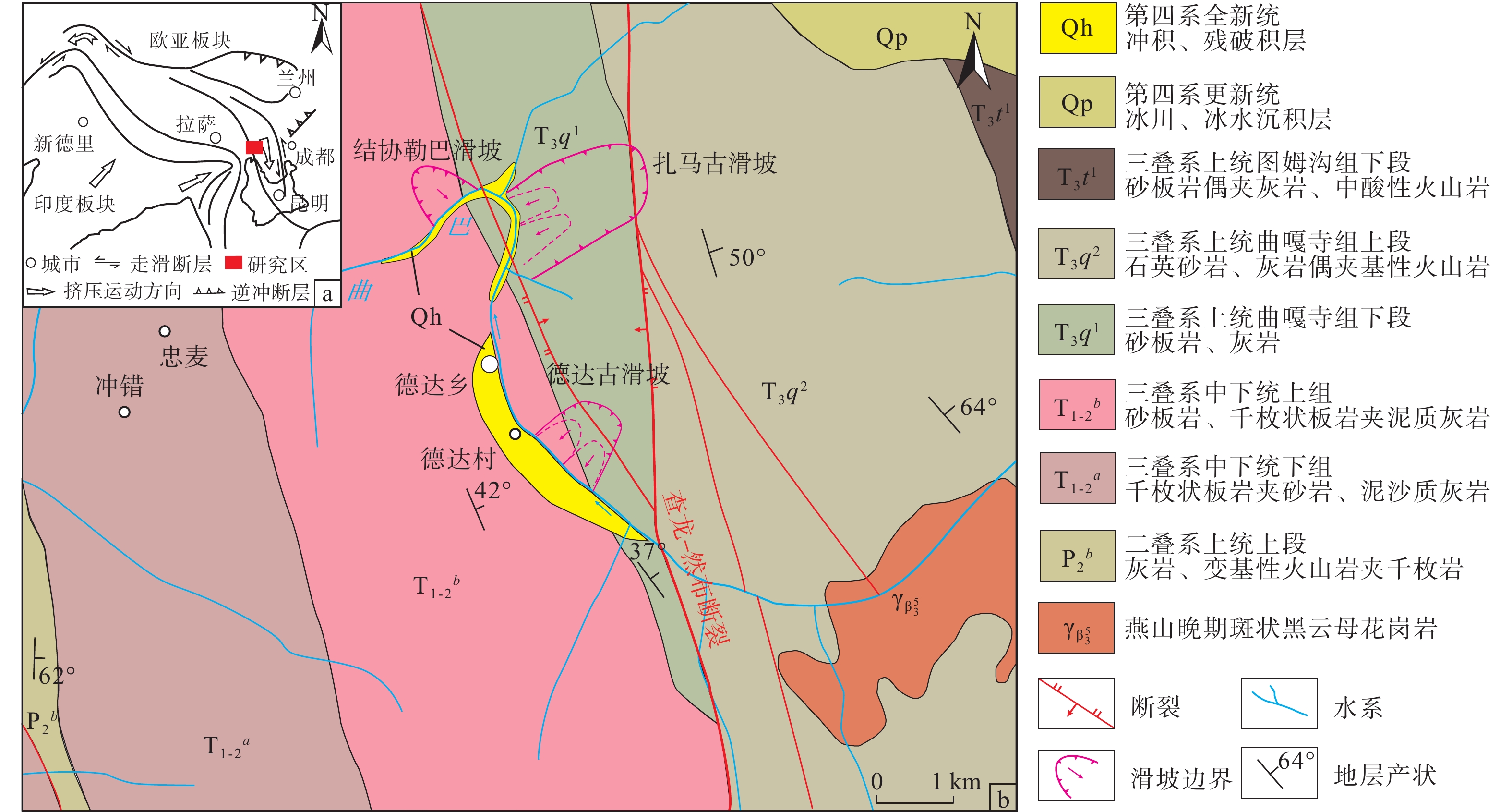
图 1 四川省巴塘县德达古滑坡区域地质图
a—青藏高原构造地质简图;b—德达古滑坡构造位置与地层岩性分布图
Figure 1. Regional geological map of the ancient Deda landslide in Batang County, Sichuan Province
(a) Regional structural geological map of the Qinghai-Tibet Plateau; (b) Structure location and stratigraphic lithology distribution map of the ancient Deda landslide

图 2 德达古滑坡平面发育特征与现场调查照片
a—德达古滑坡工程地质平面图;b—德达古滑坡前缘复活变形(镜向NW);c—德达古滑坡后壁区(Ⅲ)断裂陡坎(镜向NE);d—德达古滑坡滑坡平台(镜向NE)
Figure 2. Planar development characteristics and on-site investigation photos of the ancient Deda landslide
(a) Engineering geological plan of the ancient Deda landslide; (b) Front reactivation deformation of the ancient Deda landslide (mirror to NW); (c) Back wall (III) fault scarp of the ancient Deda landslide (mirror to NE); (d) Platform of the ancient Deda landslide (mirror to NE)

图 3 德达古滑坡微动探测反演结果剖面图
a—德达古滑坡A—A′剖面微动探测反演结果;b—德达古滑坡B—B′剖面微动探测反演结果
Figure 3. Inversion results of microtremor surveys method (MSM) in the section of the ancient Deda landslide
(a) Inversion results of MSM in the A-A′ section of the ancient Deda landslide; (b) Inversion results of MSM in the B-B′ section of the ancient Deda landslide

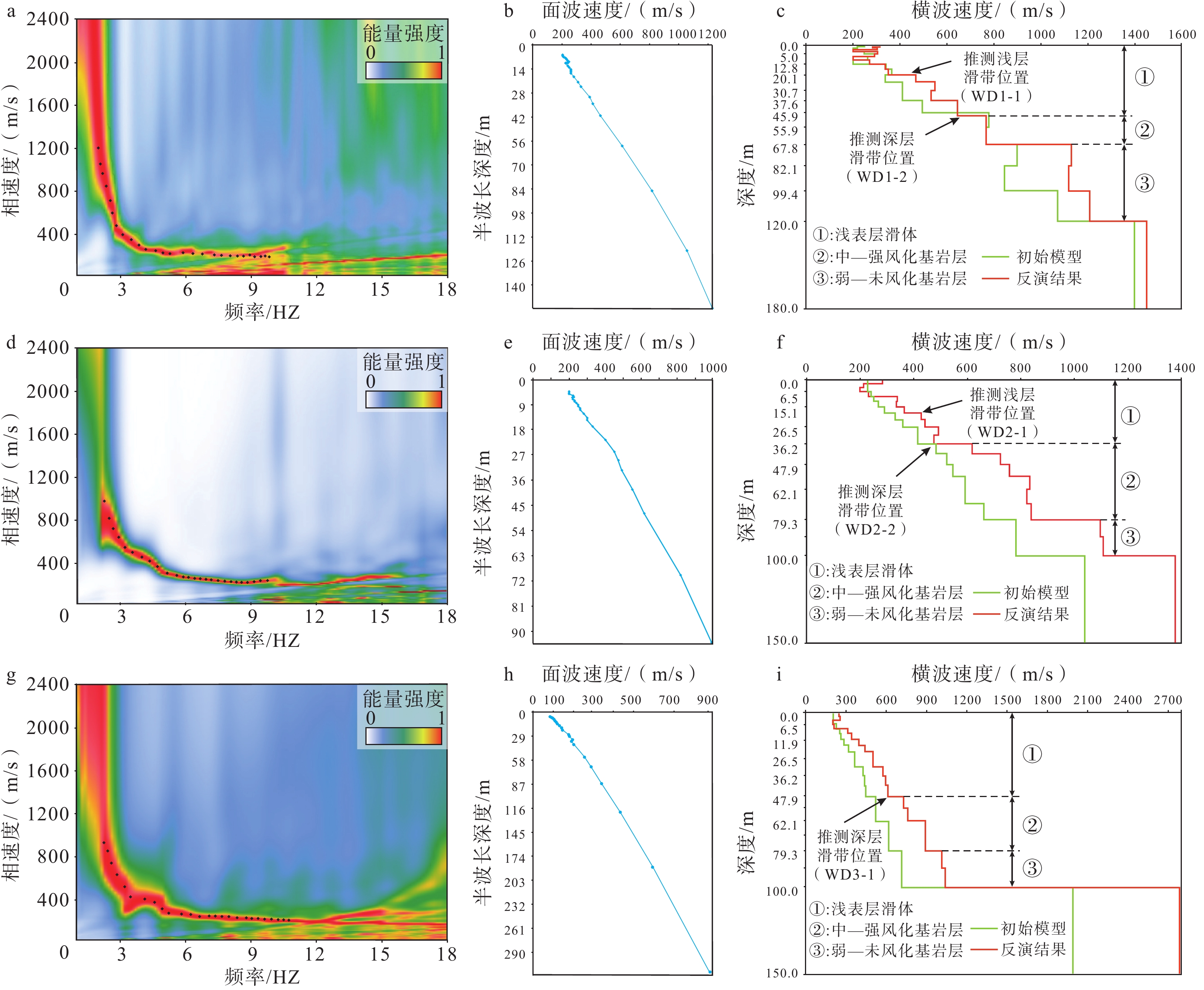
图 4 德达I号滑坡体微动勘探点地球物理响应特征图
a—WD1频散能量谱;b—WD1频散曲线;c—WD1横波速度结构反演;d—WD2频散能量谱;e—WD2频散曲线;f—WD2横波速度结构反演;g—WD3频散能量谱;h—WD3频散曲线;i—WD3横波速度结构反演
Figure 4. Geophysical response characteristics of microtremor surveys method (MSM) points on the Deda I landslide
(a) Dispersion energy spectrum of WD1 point; (b) Dispersion curve of WD1 point; (c) Inversion of WD1 shear wave velocity structure; (d) Dispersion energy spectrum of WD2 point; (e) Dispersion curve of WD2 point; (f) Inversion of WD2 shear wave velocity structure; (g) Dispersion energy spectrum of WD3 point; (h) Dispersion curve of WD3 point; (i) Inversion of WD3 shear wave velocity structure

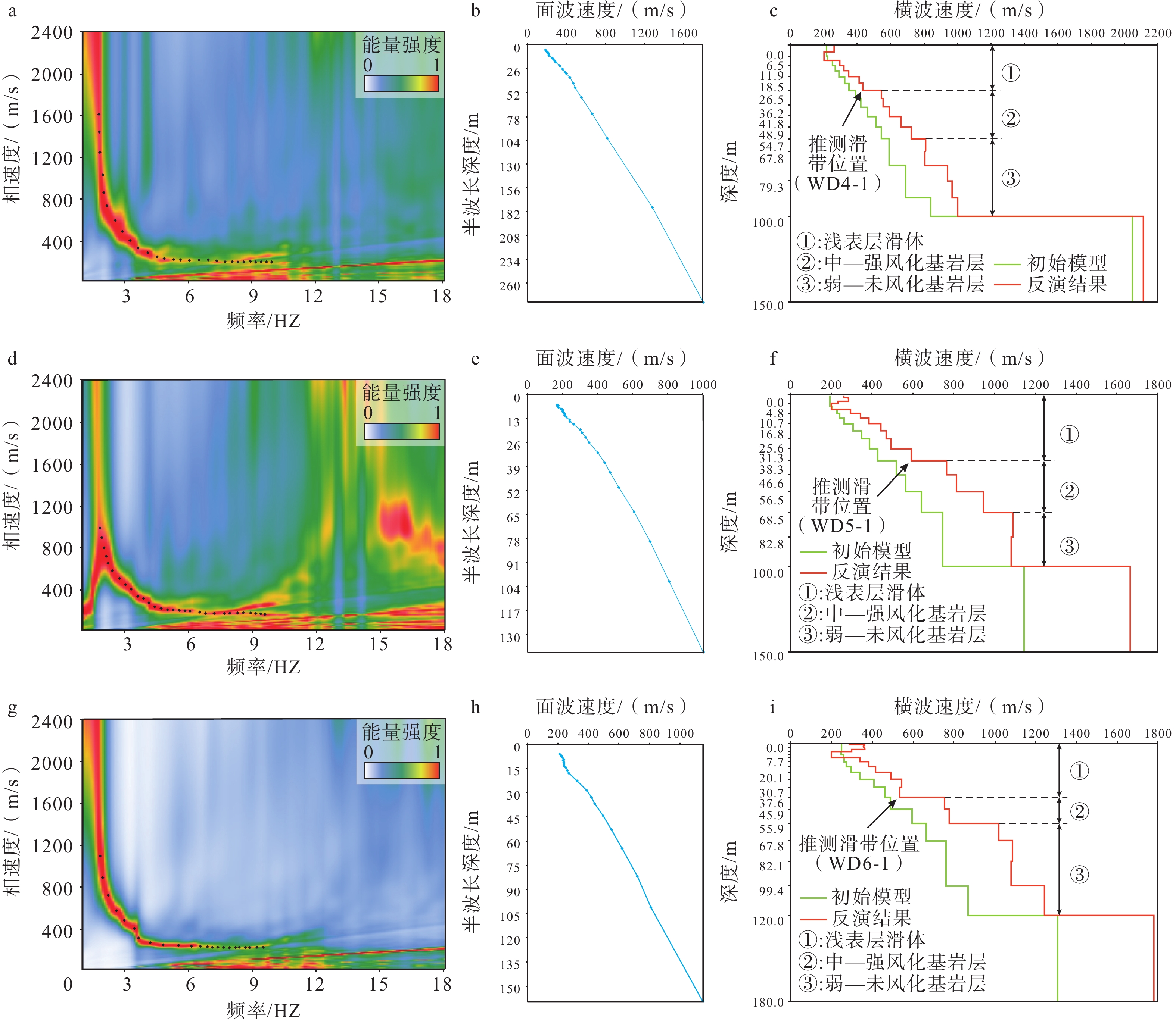
图 5 德达Ⅱ号滑坡体微动勘探点地球物理响应特征图
a—WD4频散能量谱;b—WD4频散曲线;c—WD4横波速度结构反演;d—WD5频散能量谱;e—WD5频散曲线;f—WD5横波速度结构反演;g—WD6频散能量谱;h—WD6频散曲线;i—WD6横波速度结构反演
Figure 5. Geophysical response characteristics of microtremor surveys method (MSM) points on the Deda Ⅱ landslide
(a) Dispersion energy spectrum of WD4 point; (b) Dispersion curve of WD4 point; (c) Inversion of WD4 shear wave velocity structure; (d) Dispersion energy spectrum of WD5 point; (e) Dispersion curve of WD5 point; (f) Inversion of WD5 shear wave velocity structure; (g) Dispersion energy spectrum of WD6 point; (h) Dispersion curve of WD6 point; (i) Inversion of WD6 shear wave velocity structure

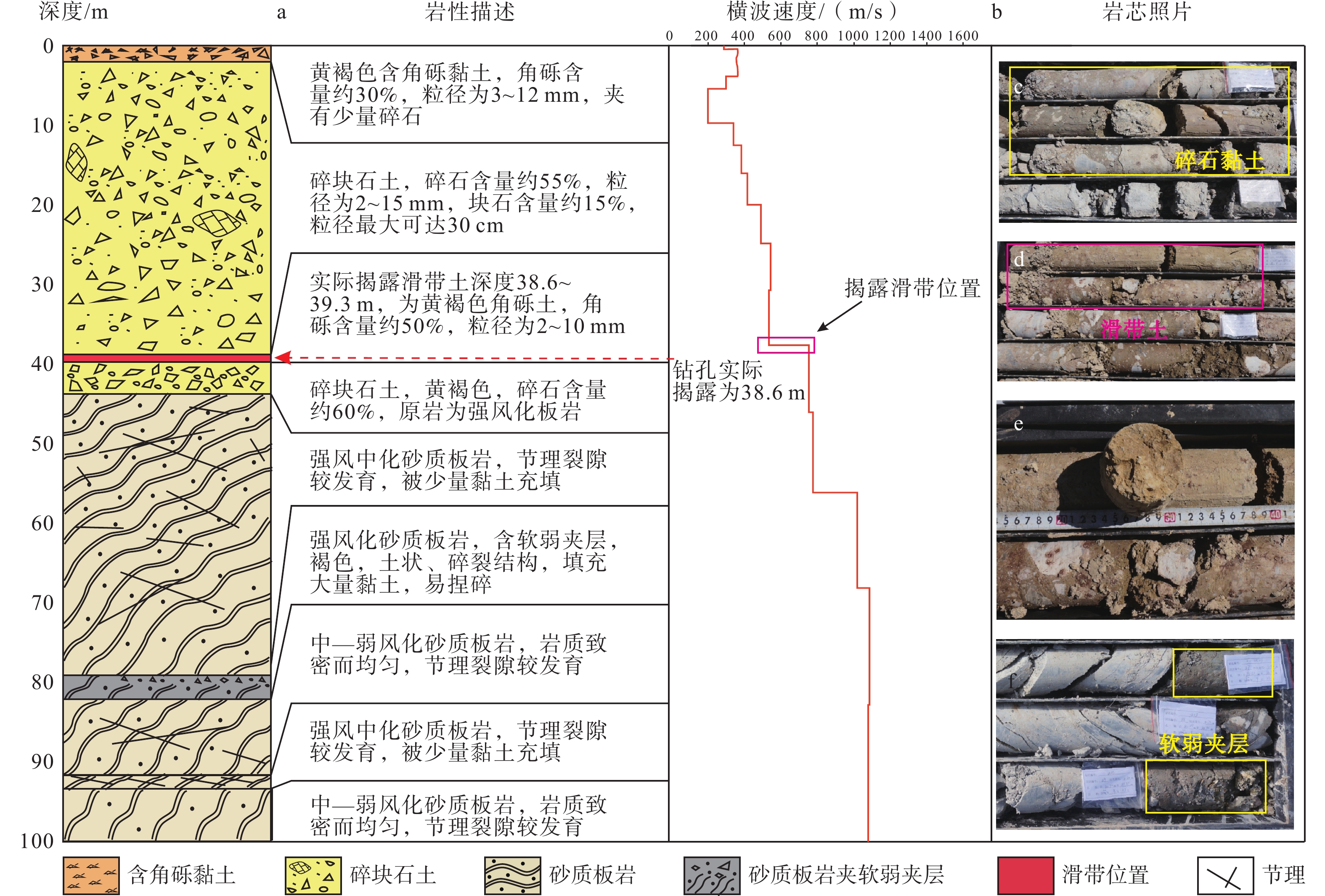
图 6 德达古滑坡ZK1钻孔柱状图
a—ZK1揭露地层特征;b—WD1横波速度结构特征;c—碎石黏土(钻孔深度20.1~20.3 m);d—滑带土(钻孔深度49.7~49.9 m);e—滑带土断面;f—软弱夹层钻孔深度为(钻孔深度70.9~72.4 m)
Figure 6. Column diagram of the ZK1 borehole in the ancient Deda landslide
(a) ZK1 reveals the stratigraphic characteristics; (b) WD1 shear wave velocity structure characteristics; (c) Gravelly clay (borehole depth 20.1~20.3 m); (d) Sliding zone (borehole depth 49.7~49.9 m); (e) Sliding zone cross-section; (f) Soft interlayer (borehole depth 70.9~72.4 m)

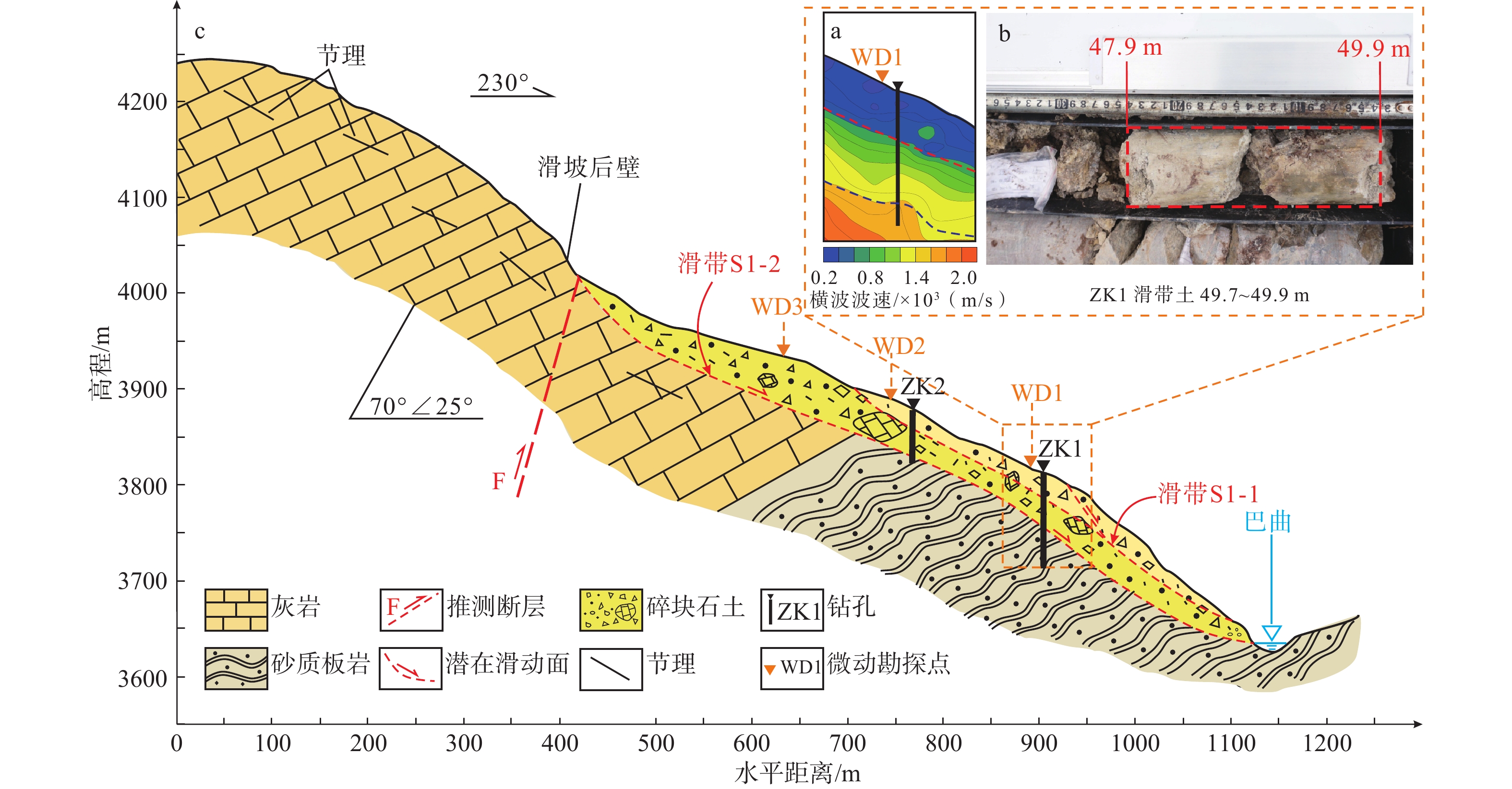
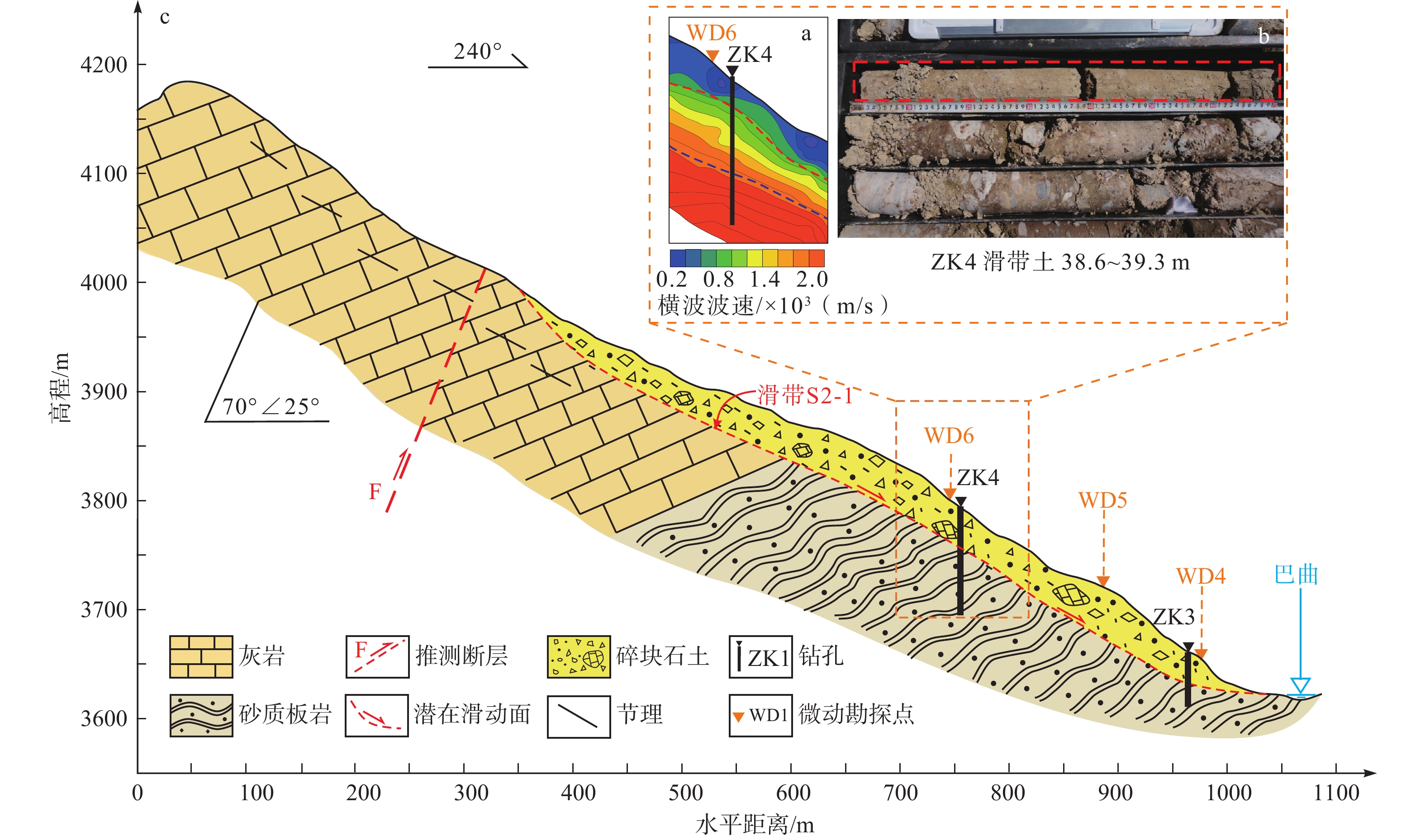
图 7 德达Ⅰ号滑坡体结构特征图
a—ZK1微动探测响应特征;b—ZK1揭露滑带土;c—德达Ⅰ号滑坡体工程地质剖面图
Figure 7. Structural characteristics of the Deda Ⅰ landslide
(a) MSM response characteristics of ZK1; (b) Sliding zone of ZK1; (c) Engineering geological profile of the Deda Ⅰ landslide

图 8 德达古滑坡ZK4钻孔柱状图
a—ZK4揭露地层特征;b—WD6横波速度结构特征;c—碎石黏土(钻孔深度24.8~26.6 m);d—滑带土(钻孔深度38.6~39.3 m);e—滑带土断面;f—软弱夹层(钻孔深度78.9和81.3 m)
Figure 8. Column diagram of the ZK4 borehole in the ancient Deda landslide
(a) ZK4 reveals the stratigraphic characteristics; (b) WD6 shear wave velocity structure characteristics; (c) Gravelly clay (borehole depth 24.8~26.6 m); (d) Sliding zone (borehole depth 38.6~39.3 m); (e) Sliding zone cross-section; (f) Soft interlayer (borehole depth 78.9 m and 81.3 m)

图 9 德达Ⅱ号滑坡体结构特征图
a—ZK4微动探测响应特征;b—ZK4揭露滑带土;c—德达Ⅱ号滑坡体工程地质剖面图
Figure 9. Structural characteristics of the Deda Ⅱ landslide
(a) MSM response characteristics of ZK4; (b) Sliding zone of ZK4; (c) Engineering geological profile of the Deda Ⅱ landslide

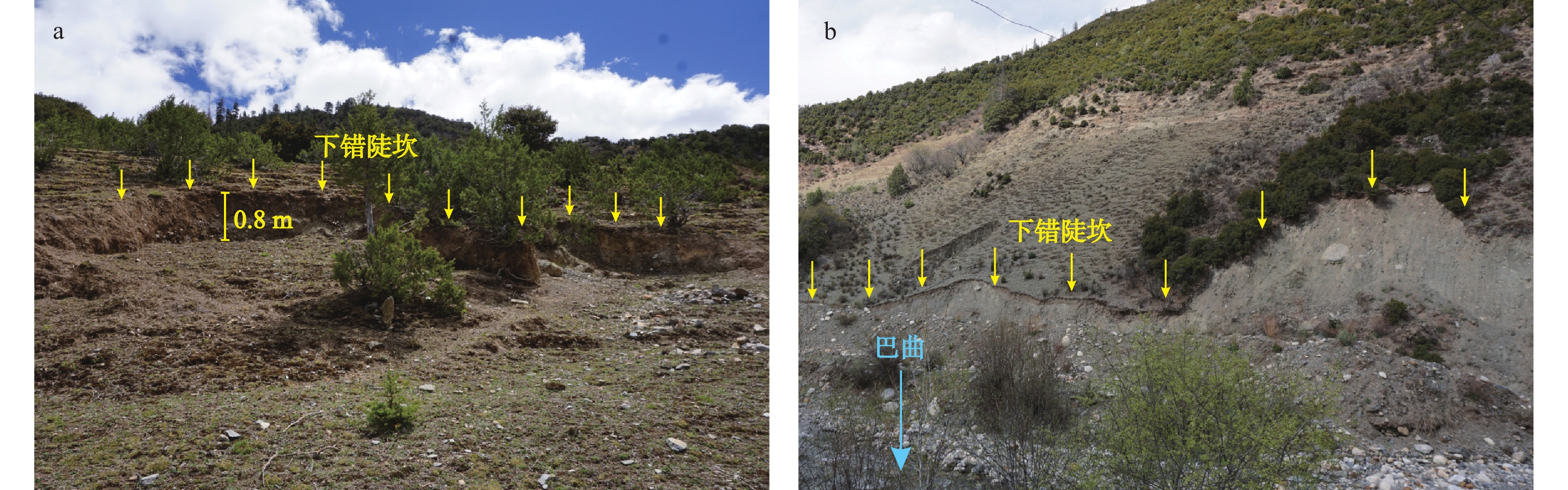
图 10 降雨及河流侵蚀对德达古滑坡的影响
a—德达古滑坡浅表层滑动(镜向NE);b—河流侧蚀造成失稳变形(镜向NW)
Figure 10. Influence of rainfall and river erosion on the ancient Deda landslide
(a) Shallow surface slide of the ancient Deda landslide (mirror to NE); (b) River erosion caused instability deformation (mirror to NW)

图 11 德达古滑坡形成机制模式图
a—滑坡后缘节理面发育贯通阶段;b—震动−崩解−铲刮−堆积阶段;c—崩滑体堆积−堵江−溃坝阶段;d—降雨入渗−河流冲刷−蠕滑变形阶段
Figure 11. Schematic diagram of the ancient Deda landslide formation mechanism
(a) Development of the joint surface at the rear edge of the landslide; (b) Shaking-disintegrating-scraping-accumulation stage; (c) Rockslide accumulation-river blocking-dam breach stage; (d) Rainfall infiltration-river erosion-creep deformation stage
表 1 德达古滑坡微动探测响应与横波速度一览表
Table 1. List of microtremor surveys method (MSM) response characteristics of the ancient Deda landslide
微动勘探点 浅表层滑体横波速度/
(m/s)中—强风化基岩横波速度
(灰岩、砂质板岩)/(m/s)弱—未风化基岩横波速度
(灰岩、砂质板岩)/(m/s)滑带横波速度/(m/s) 滑带编号 浅层滑带 滑带编号 深层滑带 WD1 200.0~644.2 644.2~766.0 766.0~1206.1 WD1-1 349.5 WD1-2 644.2 WD2 198.7~492.2 492.2~840.8 840.8~1110.4 WD2-1 365.1 WD2-2 475.2 WD3 200.0~618.0 618.0~888.7 888.7~1006.5 / / WD3-1 618.0 WD4 200.0~432.4 432.4~718.5 718.5~1000.0 / / WD4-1 432.4 WD5 200.0~590.8 590.8~939.0 939.0~1056.1 / / WD5-1 590.8 WD6 200.0~543.1 543.1~776.7 776.7~1240.8 / / WD6-1 543.1  下载: 导出CSV
表 2 德达古滑坡微动勘探点与钻探结果对比
Table 2. Comparison of MSM points and drilling results of the ancient Deda landslide
名称 位置 滑带深度/m 相对误差/% 德达Ⅰ号滑坡体 WD1 47.3 4.8 ZK1 49.7 WD2 18.7 4.1 ZK2 19.5 德达Ⅱ号滑坡体 WD3 26.4 4.7 ZK3 25.2 WD4 37.6 2.6 ZK4 38.6
下载: 导出CSV
-
[1] AKI K, 1957. Space and time spectra of stationary stochastic waves, with special reference to microtremors[J]. Bulletin of the Earthquake Research Institute, 35(3): 415-456. [2] BAI Y J, LI M H, WANG D H, et al., 2014. Characteristics and disastrous rule research of Geohazards in Batang county, the middle reaches of Jinsha river[J]. The Chinese Journal of Geological Hazard and Control, 25(2): 103-109. (in Chinese with English abstract [3] CAPON J, 1969. High-resolution frequency-wavenumber spectrum analysis[J]. Proceedings of the IEEE, 57(8): 1408-1418. doi: 10.1109/PROC.1969.7278 [4] CRUDEN D M, VARNES D J, 1996. Landslide types and processes, special report, transportation research board[J]. U. S. National Academy of Sciences, Special Report, 247: 36-75. [5] DEWEY J F, SHACKLETON R M, CHANG C F, et al., 1988. The tectonic evolution of the Tibetan Plateau[J]. Philosophical Transactions of the Royal Society A: Mathematical, Physical and Engineering Sciences, 327(1594): 379-413. [6] DU Y N, XU P F, LING S Q, 2018. Microtremor survey of soil-rock mixture landslides: an example of Baidian township, Hengyang City[J]. Chinese Journal of Geophysics, 61(4): 1596-1604. (in Chinese with English abstract [7] GAO W W, GAO W, HU R L, et al., 2018. Microtremor survey and stability analysis of a soil-rock mixture landslide: a case study in Baidian town, China[J]. Landslides, 15(10): 1951-1961. doi: 10.1007/s10346-018-1009-x [8] GUO C B, ZHANG Y S, MONTGOMERY D R, et al., 2016. How unusual is the long-runout of the earthquake-triggered giant Luanshibao landslide, Tibetan Plateau, China?[J]. Geomorphology, 259: 145-154. [9] GUO C B, YAN Y Q, ZHANG Y S, et al., 2022. Research progress and prospect of failure mechanism of large deep-seated creeping landslides in Tibetan Plateau, China[J]. Earth Science, 47(10): 3677-3700. (in Chinese with English abstract [10] GUO C B, ZHANG Y S, YUAN H, et al., 2023. Study of an ancient landslide reactivation mechanism based on centrifuge model testing: an example of the Jiangdingya ancient landslide reactivation in 2018, Gansu province, China[J]. Landslides, 20(1): 127-141. doi: 10.1007/s10346-022-01978-5 [11] GUO Q Q, GUO C B, SHEN W, et al., 2017. Geophysical exploration and sliding surface discriminant analysis of large-giant ancient landslides in Minjiang river valley, Western Sichuan[J]. Journal of Geomechanics, 23(5): 788-797. (in Chinese with English abstract [12] HUANG R Q, 2007. Large-scale landslides and their sliding mechanisms in China since the 20th century[J]. Chinese Journal of Rock Mechanics and Engineering, 26(3): 433-454. (in Chinese with English abstract [13] LI X, LI S D, CHEN J, et al., 2008. Coupling effect mechanism of endogenic and exogenic geological processes of geological hazards evolution[J]. Chinese Journal of Rock Mechanics and Engineering, 27(9): 1792-1806. (in Chinese with English abstract [14] LI X, LIAO Q L, WANG S J, et al., 2008. On evaluating the stability of the Baiyian ancient landslide in the three gorges reservoir area, Yangtze River: a geological history analysis[J]. Environmental Geology, 55(8): 1699-1711. doi: 10.1007/s00254-007-1121-z [15] LONG R, LIU X D, 2023. Study on Stability Evaluation and Treatment Scheme of Highway Landslide Based on Disaster Mechanism Analysis[J]. Railway Investigation and Surveying, 49(2): 33-37. [16] MA N, WANG G W, KAMAI T, et al., 2019. Amplification of seismic response of a large deep-seated landslide in Tokushima, Japan[J]. Engineering Geology, 249: 218-234. doi: 10.1016/j.enggeo.2019.01.002 [17] MOLNAR S, SIROHEY A, ASSAF J, et al., 2022. A review of the microtremor horizontal-to-vertical spectral ratio (MHVSR) method[J]. Journal of Seismology, 26(4): 653-685. doi: 10.1007/s10950-021-10062-9 [18] NAUDET V, LAZZARI M, PERRONE A, et al., 2008. Integrated geophysical and geomorphological approach to investigate the snowmelt-triggered landslide of Bosco Piccolo village (Basilicata, southern Italy)[J]. Engineering Geology, 98(3-4): 156-167. doi: 10.1016/j.enggeo.2008.02.008 [19] PENG J B, MA R Y, LU Q Z, et al., 2004. Geological hazards effects of uplift of Qinghai-Tibet Plateau[J]. Advances in Earth Science, 19(3): 457-466. (in Chinese with English abstract [20] QIU Z D, GUO C B, WU R A, et al., 2024. Development characteristics and stability evaluation of the Shadingmai large-scale ancient landslide in the upper reaches of Jinsha River, Tibetan Plateau[J]. Geoscience, 38(2): 451-463. (in Chinese with English abstract [21] SU L J, XU X Q, GENG X Y, et al., 2017. An integrated geophysical approach for investigating hydro-geological characteristics of a debris landslide in the Wenchuan earthquake area[J]. Engineering Geology, 219: 52-63. doi: 10.1016/j.enggeo.2016.11.020 [22] TIE Y B, ZHANG X Z, GONG L F, et al., 2022. Research on the pattern of typical geohazard chains in the southwest mountainous region, China[J]. Journal of Geomechanics, 28(6): 1071-1080. (in Chinese with English abstract [23] TONG P, WU S Q, XIE M, et al., 2023. Remote Sensing Interpretation and Risk Assessment of Landslide Hazards in Newly Built High-speed Railway[J]. Railway Investigation and Surveying, 49(6): 56-63. [24] WANG X F, METCALFE I, JIAN P, et al., 2000. The Jinshajiang suture zone: tectono-stratigraphic subdivision and revision of age[J]. Science in China Series D: Earth Sciences, 43(1): 10-22. doi: 10.1007/BF02877827 [25] XIE S Y, XU W Y, 1999. Mechanism of landslides induced by precipitation[J]. Journal of Wuhan University of Hydraulic and Electric Engineering, 32(1): 21-23. (in Chinese with English abstract [26] XU J R, ZHAO Z X, 2009. Extensional seismogenic stress and tectonic movement on the central region of the Tibetan Plateau[J]. International Journal of Geophysics, 2009: 897424. [27] XU P F, LI S H, DU J G, et al., 2013. Microtremor survey method: a new geophysical method for dividing strata and detecting the buried fault structures[J]. Acta Petrologica Sinica, 29(5): 1841-1845. (in Chinese with English abstract [28] XU P F, LING S Q, LONG G, et al., 2021. ESPAC-based 2D mini-array microtremor method and its application in urban rail transit construction planning[J]. Tunnelling and Underground Space Technology, 115: 104070. doi: 10.1016/j.tust.2021.104070 [29] XU Q, ZHAO B, DAI K R, et al., 2023. Remote sensing for landslide investigations: a progress report from China[J]. Engineering Geology, 321: 107156. doi: 10.1016/j.enggeo.2023.107156 [30] YAN Y Q, GUO C B, ZHONG N, et al., 2022. Deformation characteristics of Jiaju ancient landslide based on InSAR monitoring method, Sichuan, China[J]. Earth Science, 47(12): 4681-4697. (in Chinese with English abstract [31] YAN Y Q, GUO C B, LI C H, et al., 2023. The creep-sliding deformation mechanism of the Jiaju ancient landslide in the Upstream OF Dadu River, Tibetan Plateau, China[J]. Remote Sensing, 15(3): 592. [32] YANG D D, QIU H J, ZHU Y R, et al., 2021. Landslide characteristics and evolution: what we can learn from three adjacent landslides[J]. Remote Sensing, 13(22): 4579. doi: 10.3390/rs13224579 [33] YANG X H, JIANG Y W, ZHU J C, et al., 2023. Deformation characteristics and failure mechanism of the Moli landslide in Guoye Town, Zhouqu County[J]. Landslides, 20(4): 789-800. doi: 10.1007/s10346-022-02019-x [34] YAO H D, SHI C, XU W Y, et al., 2015. Landslide reactivation of Zhenggang deposit talus at Gushui hydropower station[J]. Journal of Hohai University (Natural Sciences), 43(1): 28-33. (in Chinese with English abstract [35] ZHANG Q L, 2016. Study on deformation of faults in Batang region in Western Sichuan[D]. Chengdu: Chengdu University of Technology. (in Chinese with English abstract [36] ZHANG R H, XU P F, LING S Q, et al, 2020. Detection of the soil-rock interface based on microtremor H/V spectral ratio method: a case study of the Jinan urban area[J]. Chinese Journal of Geophysics, 63(1): 339-350. (in Chinese with English abstract [37] ZHANG Y S, GUO C B, LAN H X, et al., 2015. Reactivation mechanism of ancient giant landslides in the tectonically active zone: a case study in Southwest China[J]. Environmental Earth Sciences, 74(2): 1719-1729. doi: 10.1007/s12665-015-4180-6 [38] ZHANG Y S, GUO C B, YAO X, et al., 2016. Research on the geohazard effect of active fault on the eastern margin of the Tibetan Plateau[J]. Acta Geoscientia Sinica, 37(3): 277-286. (in Chinese with English abstract [39] ZHANG Y Y, GUO C B, YANG Z H, et al., 2021. Development characteristics and reactivation trend of Zhama ancient landslide in Batang, Sichuan[J]. Geological Bulletin of China, 40(12): 2002-2014. (in Chinese with English abstract [40] ZHAO C Y, LIU X J, GAO Y, et al., 2022. Early identification of high-elevation geohazards in the lower Yarlung Zangbo River based on the SAR/InSAR technology[J]. Journal of Geomechanics, 28(6): 981-994. (in Chinese with English abstract [41] ZHOU R J, CHEN G X, LI Y, et al., 2005. Research on active faults in Litang-Batang region, western Sichuan province, and the seismogenic structures of the 1989 Batang M6.7 earthquake swarm[J]. Seismology and Geology, 27(1): 31-43. (in Chinese with English abstract [42] 白永健,李明辉,王东辉,等,2014. 金沙江中游巴塘县地质灾害发育特征及成灾规律分析[J]. 中国地质灾害与防治学报,25(2):103-109. [43] 杜亚楠,徐佩芬,凌甦群. 2018. 土石混合滑坡体微动探测:以衡阳拜殿乡滑坡体为例[J]. 地球物理学报,61(4):1596-1604. [44] 郭长宝,闫怡秋,张永双,等,2022. 青藏高原大型深层蠕滑型滑坡变形机制研究进展与展望[J]. 地球科学,47(10):3677-3700. [45] 郭桥桥,郭长宝,申维,等,2017. 川西岷江河谷典型大型—巨型古滑坡特征物探解译分析[J]. 地质力学学报,23(5):788-797. doi: 10.3969/j.issn.1006-6616.2017.05.015 [46] 黄润秋,2007. 20世纪以来中国的大型滑坡及其发生机制[J]. 岩石力学与工程学报,26(3):433-454. doi: 10.3321/j.issn:1000-6915.2007.03.001 [47] 李晓,李守定,陈剑,等,2008. 地质灾害形成的内外动力耦合作用机制[J]. 岩石力学与工程学报,27(9):1792-1806. doi: 10.3321/j.issn:1000-6915.2008.09.006 [48] 隆然,刘兴东,2023. 基于致灾机理分析的公路滑坡稳定性评价及治理方案研究[J]. 铁道勘察,49(2):33-37. [49] 彭建兵,马润勇,卢全中,等,2004. 青藏高原隆升的地质灾害效应[J]. 地球科学进展,19(3):457-466. doi: 10.3321/j.issn:1001-8166.2004.03.018 [50] 邱振东,郭长宝,吴瑞安,等,2024. 金沙江上游沙丁麦大型古滑坡发育特征与稳定性评价[J]. 现代地质,38(2):451-463. [51] 铁永波,张宪政,龚凌枫,等,2022. 西南山区典型地质灾害链成灾模式研究[J]. 地质力学学报,28(6):1071-1080. doi: 10.12090/j.issn.1006-6616.20222830 [52] 童鹏,伍尚前,谢猛,等,2023. 新建高速铁路滑坡隐患遥感解译及风险评估[J]. 铁道勘察,49(6):56-63. [53] 谢守益,徐卫亚,1999. 降雨诱发滑坡机制研究[J]. 武汉水利电力大学学报,32(1):21-23. [54] 徐佩芬,李世豪,杜建国,等,2013. 微动探测:地层分层和隐伏断裂构造探测的新方法[J]. 岩石学报,29(5):1841-1845. [55] 闫怡秋,郭长宝,钟宁,等,2022. 基于InSAR形变监测的四川甲居古滑坡变形特征[J]. 地球科学,47(12):4681-4697. [56] 姚贺冬,石崇,徐卫亚,等,2015. 古水水电站争岗堆积体滑坡复活条件分析[J]. 河海大学学报(自然科学版),43(1):28-33. doi: 10.3876/j.issn.1000-1980.2015.01.006 [57] 张清林,2016. 川西巴塘地区断裂构造变形研究[D]. 成都:成都理工大学. [58] 张永双,郭长宝,姚鑫,等,2016. 青藏高原东缘活动断裂地质灾害效应研究[J]. 地球学报,37(3):277-286. doi: 10.3975/cagsb.2016.03.03 [59] 张若晗,徐佩芬,凌甦群,等,2020. 基于微动H/V谱比法的土石分界面探测研究:以济南中心城区为例[J]. 地球物理学报,63(1):339-350. doi: 10.6038/cjg2020M0678 [60] 张怡颖,郭长宝,杨志华,等,2021. 四川巴塘扎马古滑坡发育特征与复活趋势[J]. 地质通报,40(12):2002-2014. doi: 10.12097/j.issn.1671-2552.2021.12.003 [61] 赵超英,刘晓杰,高杨,等,2022. 基于SAR/InSAR技术的雅鲁藏布江下游高位地质灾害早期识别[J]. 地质力学学报,28(6):981-994. doi: 10.12090/j.issn.1006-6616.20222825 [62] 周荣军,陈国星,李勇,等,2005. 四川西部理塘—巴塘地区的活动断裂与1989年巴塘6.7级震群发震构造研究[J]. 地震地质,27(1):31-43. doi: 10.3969/j.issn.0253-4967.2005.01.004 -

 下载:
下载:


计量
- 文章访问数: 1336
- HTML全文浏览量: 268
- PDF下载量: 110
- 被引次数: 0
