

Characteristics and risk assessment of debris flows in the Wandong catchment after the MS 6.8 Luding earthquake
-
摘要:
2022年9月5日四川泸定县发生MS 6.8级地震, 地震诱发大量同震崩滑体, 并导致湾东河断流。基于现场调查、影像解译和区域地质资料分析, 采用空间统计和水文计算的方法, 对湾东河流域同震崩滑体分布特征和潜在泥石流危险性进行了研究。结果表明: 湾东河流域内同震崩滑体主要分布在地震烈度Ⅸ度区, 规模以中小型为主, 主要沿沟道两侧展布, 尤其是单薄山脊两侧临空面发育密度较大, 距断层距离和坡度对其分布具有明显的控灾效应; 未来湾东河流域暴发溃决型泥石流的冲出量可能为同等触发条件下震前泥石流的约两倍。依此提出了加强流域内溃决型泥石流风险防范, 尽快通过综合监测预警获取泥石流发生的临界雨量值, 在泥石流防治工程设计中应充分考虑泥石流规模放大系数等防灾减灾建议, 为泸定地震后泥石流灾害防灾减灾提供科学参考。
Abstract:On Sep. 5, 2022, an MS 6.8 earthquake struck Luding County. The earthquake triggered large amounts of co-seismic landslides, which blocked the Wandong River for nearly 24 hours. Field surveys, image interpretation, spatial statistics, and hydro-logical calculations were used to investigate the characteristics of co-seismic landslides and the risk of debris flow following the earthquake. According to the findings, co-seismic landslides are primarily found in areas of earthquake intensity IX, and their sizes are typically small and medium. They are distributed along both sides of the channel, particularly on both sides of the thin ridge facing the air. The distance from the fault and slope controls the distribution of co-seismic landslides. The volume of debris flow runout in the Wandong catchment may be twice that of the debris flow prior to the earthquake. On this basis, the following disaster prevention and mitigation suggestions were put forward. The risk of runout debris flow in the catchment should be strengthened; The value of triggering rainfall of debris flow should be obtained as soon as possible through comprehensive monitoring and early warning; The scale amplification factor of debris flow should be fully considered in the design of debris flow prevention and control projects. This research can be used as a scientific reference for disaster prevention and mitigation of post-earthquake debris flows.
-

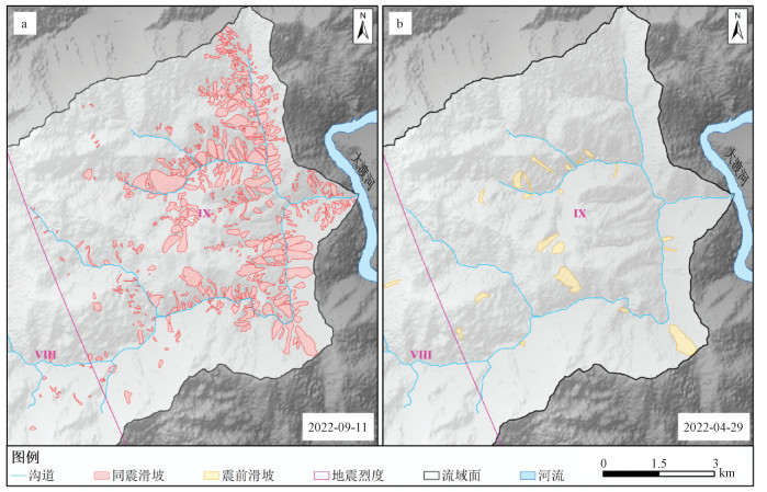
图 3 泸定地震震前和震后崩滑体分布图
a—同震崩滑体分布图;b—震前崩滑体分布图
Figure 3. Landslide distribution map of pre and post the Luding earthquake
(a) Co-seismic landslide distribution map; (b) Pre-seismic landslide distribution map

图 5 同震崩滑体面积及密度与距断层距离的关系统计图
Figure 5. Graph of co-seismic landslide area and density vesus distance from fault

图 6 同震崩滑体面积及密度与高程的关系统计图
Figure 6. Graph of co-seismic landslide area and density vesus elevation

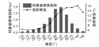
图 7 同震崩滑体面积与坡度的关系统计图
Figure 7. Graph of co-seismic landslide area and density vesus slope steepness

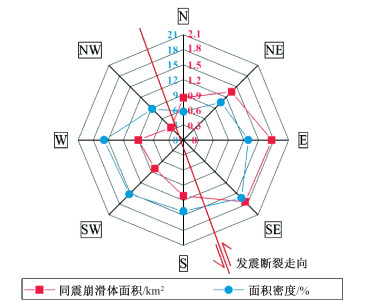
图 8 同震崩滑体面积及密度与坡向的关系雷达图
Figure 8. Radar graph of co-seismic landslide area and density vesus aspect

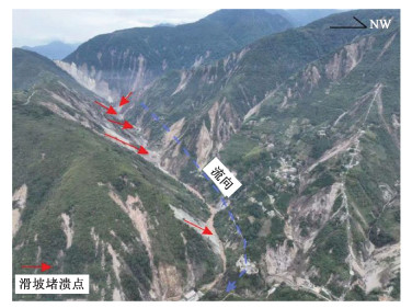
图 9 堆积在沟道中的同震崩滑体碎屑物
Figure 9. The debris deposition of co-seismic landslides along the channel

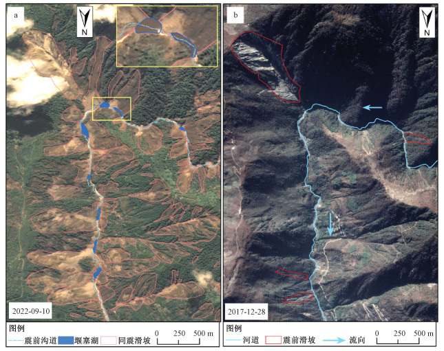
图 10 泸定地震震前和震后湾东河主沟下游滑坡发育及堰塞湖分布情况
a—地震后河道堵塞形成堰塞湖分布图(影像来源于高分6号);b—地震前河道情况(影像来源于谷歌地图)
Figure 10. The distribution of co-seismic landslides and dammed lakes in the main downstream channel of the Wandong catchment pre and post the Luding earthquake
(a) The distribution of the dammed lakes formed by co-seismic landslides (The image is from GF6); (b) The state of the channel before the earthquake (The image is from Google Earth)
表 1 数据清单
Table 1. Data list
类型 分辨率 来源 岩性数据 1∶5万 成都地质调查中心 高程数据 12.5 m ALOS全球数字地表模型
(https://www.eorc.jaxa.jp)多光谱影像数据 10 m 哨兵2;日期:2022-09-11、2021-04-29
(https://scihub.copernicus.eu)全彩影像 2 m 高分2号、高分6号;日期:2022-09-10
(由四川省地质调查院提供) 下载: 导出CSV
表 2 泥石流冲出量计算参数表
Table 2. Parameters of debris flow runout
流域名称 容重/(t/m3) 堵塞系数 湾东河主沟 1.80 4.5 红岩沟 2.15 3.5 银厂沟 2.15 3.5
下载: 导出CSV
表 3 震后湾东沟流域不同频率下泥石流特征值
Table 3. Characteristic values of debris flow at different frequencies in the Wandong catchment
参数 流域名称 降雨频率P/% 5 2 1 0.5 洪水洪峰流量/(m3/s) 湾东河 281 338 376 461 红岩沟 92 106 117 139 银厂沟 68 77 85 99 泥石流洪峰流量/(m3/s) 湾东河 1330 1600 1778 2178 红岩沟 606 702 770 915 银厂沟 451 512 558 652 一次冲出固体物质总量/(×105 m3) 湾东河 6.8* 6.7* 7.9* 8.9* 红岩沟 1.5 1.7 1.9 2.3 银厂沟 1.1 1.3 1.4 1.6 *假定主沟道内8个堰塞湖全部溃决,可提供3.6×10⁵ m3的固体物质
下载: 导出CSV
-
BARTH S, GEERTSEMA M, BEVINGTON A R, et al., 2020. Landslide response to the 27 October 2012 earthquake (MW 7.8), southern Haida Gwaii, British Columbia, Canada[J]. Landslides, 17(3): 517-526. doi: 10.1007/s10346-019-01292-7 CHANG M, TANG C, VAN ASCH T W J, et al., 2017. Hazard assessment of debris flows in the Wenchuan earthquake-stricken area, South West China[J]. Landslides, 14(5): 1783-1792. doi: 10.1007/s10346-017-0824-9 CHEN M, TANG C, XIONG J, et al., 2020. The long-term evolution of landslide activity near the epicentral area of the 2008 Wenchuan earthquake in China[J]. Geomorphology, 367: 107317. doi: 10.1016/j.geomorph.2020.107317 CHEN M, TANG C, LI M W, et al., 2022. Changes of surface recovery at coseismic landslides and their driving factors in the Wenchuan earthquake-affected area[J]. CATENA, 210: 105871. doi: 10.1016/j.catena.2021.105871 CHEN S J, ZHENG X, WANG J B, et al., 2020. Risk analysis of cascade landslide dam based on an approach of quick breach flood calculation[J]. Water Resources and Hydropower Engineering, 51(3): 82-90. (in Chinese with English abstract) China Association of Geological Hazard Prevention, 2018. Specification of geological investigation for debris flow stabilization[S]. Beijing, 4: 47-50. (in Chinese) FAN X M, SCARINGI G, KORUP O, et al., 2019. Earthquake-induced chains of geologic hazards: patterns, mechanisms, and impacts[J]. Reviews of Geophysics, 57(2): 421-503. doi: 10.1029/2018RG000626 FANG Q S, TANG C, 2016. Study on run-out amount of break and general debris flows in Wenchuan Earthquake area[J]. Journal of Catastrophology, 31(1): 66-71. (in Chinese with English abstract) doi: 10.3969/j.issn.1000-811X.2016.01.014 GAO D D, WU Y, CHEN M, et al., 2015. Baseflow separation and rainfall infiltration calculation of small watershed in Gongga mountain forest system[J]. Resources and Environment in the Yangtze Basin, 24(6): 949-955. (in Chinese with English abstract) GE Y G, CUI P, ZHANG J Q, et al., 2015. Catastrophic debris flows on July 10th 2013 along the Min River in areas seriously-hit by the Wenchuan earthquake[J]. Journal of Mountain Science, 12(1): 186-206. doi: 10.1007/s11629-014-3100-7 HUANG R Q, LI W L, 2008. Research on development and distribution rules of Geohazards induced by Wenchuan earthquake on 12th May, 2008[J]. Chinese Journal of Rock Mechanics and Engineering, 27(12): 2585-2592. (in Chinese with English abstract) doi: 10.3321/j.issn:1000-6915.2008.12.028 HUANG X, TANG C, 2017. Quantitative analysis of dynamic features for entrainment-outburst-induced catastrophic debris flows in Wenchuan earthquake area[J]. Journal of Engineering Geology, 25(6): 1491-1500. (in Chinese with English abstract) LIN C W, SHIEH C L, YUAN B D, et al., 2004. Impact of Chi-Chi earthquake on the occurrence of landslides and debris flows: example from the Chenyulan River watershed, Nantou, Taiwan[J]. Engineering Geology, 71(1-2): 49-61. doi: 10.1016/S0013-7952(03)00125-X LIU Z, LI B, HE K, et al., 2020. Research of dynamic response patterns of high steep rock slope under earthquake effects[J]. Journal of Geomechanics, 26(1): 115-124. (in Chinese with English abstract) NI H Y, 2016. Influence of rainfall patterns on debris flow initiation and critical rainfall condition[D]. Chengdu: Chengdu University of Technology: 21-22. (in Chinese with English abstract) POURGHASEMI H R, JIRANDEH A G, PRADHAN B, et al., 2013. Landslide susceptibility mapping using support vector machine and GIS at the Golestan Province, Iran[J]. Journal of Earth System Science, 122(2): 349-369. doi: 10.1007/s12040-013-0282-2 SHE T, XIE H, WANG S G, et al., 2008. Characteristics and hazard assessment of Wandong river debris flow on east slope of Gongga mountain[J]. Research of Soil and Water Conservation, 15(3): 242-245. (in Chinese with English abstract) Sichuan Provincial Water Resources Department, 1984. Specification of rainstorm and flood calculation in medium and small catchments of Sichuan Province[M]. Chengdu: Sichuan Provincial Water Resources Department, 6: 8-17. (in Chinese) SONG Z, BA R J, LIU Y J, 2010. Analysis on blocking of the Dadu river by a giant debris flow of Moxi River: quantitative calculation of scale of a debris flow and flows of different frequencies by rain-flood method[J]. Journal of Catastrophology, 25(2): 73-75. (in Chinese with English abstract) doi: 10.3969/j.issn.1000-811X.2010.02.015 TANG C, ZHU J, DING J, et al., 2011. Catastrophic debris flows triggered by a 14 August 2010 rainfall at the epicenter of the Wenchuan earthquake[J]. Landslides, 8(4): 485-497. doi: 10.1007/s10346-011-0269-5 TANG C, VAN WESTEN C, 2018. Atlas of Wenchuan-earthquake geohazards[M]. Beijing: Science Press: 17-18. TANG C X, VAN WESTEN C J, TANYAS H, et al., 2016. Analysing post-earthquake landslide activity using multi-temporal landslide inventories near the epicentral area of the 2008 Wenchuan earthquake[J]. Natural Hazards and Earth System Sciences, 16(12): 2641-2655. doi: 10.5194/nhess-16-2641-2016 TIE Y B, LI Z L, 2011. Characteristics of debris flow development and its environmental response in Moxi River basin[J]. Yangtze River, 42(13): 40-43, 71. (in Chinese with English abstract) doi: 10.3969/j.issn.1001-4179.2011.13.010 TIE Y B, ZHANG X Z, LU J Y, et al., 2022. Characteristics of geological hazards and it's mitigations of the Ms6.8 earthquake in Luding County, Sichuan Province[J/OL]. Hydrogeology & Engineering Geology, 49: 1-12[2022-09-27]. https://www.swdzgcdz.com/cn/article/doi/10.16030/j.cnki.issn.1000-3665.202209023. (in Chinese with English abstract) WANG D H, TIAN K, 2014. Spatial distribution analysis of seismic landslides along Luhuo segment of Xianshuihe fault zone[J]. Journal of Engineering Geology, 22(2): 292-299. (in Chinese with English abstract) doi: 10.3969/j.issn.1004-9665.2014.02.020 XIAO X, LU C Y, WU X F, 2008. Debris flow disaster and prevention countermeasures in Wandong River, Luding County[C]. Chengdu: Sichuan Society of Civil Engineering and Architecture: 181-182. (in Chinese) XIN P, WU S R, ZHANG Z L, et al., 2017. Distribution characteristics and formation mechanism of landslides triggered by activities of Baoji-Wushan segment at the northern margin of western Qinling fault zone[J]. Journal of Geomechanics, 23(5): 723-733. (in Chinese with English abstract) doi: 10.3969/j.issn.1006-6616.2017.05.009 XIONG J, TANG C, TANG H, et al., 2022. Long-term hillslope erosion and landslide-channel coupling in the area of the catastrophic Wenchuan earthquake[J]. Engineering Geology, 305: 106727. doi: 10.1016/j.enggeo.2022.106727 XU C, XU X W, 2014. The spatial distribution pattern of landslides triggered by the 20 April 2013 Lushan earthquake of China and its implication to identification of the seismogenic fault[J]. Chinese Science Bulletin, 59(13): 1416-1424. doi: 10.1007/s11434-014-0202-0 XU C, XU X W, SHYU J B H, 2015. Database and spatial distribution of landslides triggered by the Lushan, China Mw 6.6 earthquake of 20 April 2013[J]. Geomorphology, 248: 77-92. doi: 10.1016/j.geomorph.2015.07.002 XU Q, LI W L, 2010. Distribution of large-scale landslides induced by the Wenchuan earthquake[J]. Journal of Engineering Geology, 18(6): 818-826. (in Chinese with English abstract) doi: 10.3969/j.issn.1004-9665.2010.06.002 YUNUS A P, FAN X M, TANG X L, et al., 2020. Decadal vegetation succession from MODIS reveals the spatio-temporal evolution of post-seismic landsliding after the 2008 Wenchuan earthquake[J]. Remote Sensing of Environment, 236: 111476. doi: 10.1016/j.rse.2019.111476 ZHANG H W, LIU F Z, WANG J C, et al., 2022. Hazard assessment of debris flows in Kongpo Gyamda, Tibet based on FLO-2D numerical simulation[J]. Journal of Geomechanics, 28(2): 306-318. (in Chinese with English abstract) ZHANG X Z, TANG C X, LI N, et al., 2022. Investigation of the 2019 Wenchuan County debris flow disaster suggests nonuniform spatial and temporal post-seismic debris flow evolution patterns[J]. Landslides, 19(8): 1935-1956. doi: 10.1007/s10346-022-01896-6 ZHOU W, TANG C, 2014. Rainfall thresholds for debris flow initiation in the Wenchuan earthquake-stricken area, southwestern China[J]. Landslides, 11(5): 877-887. doi: 10.1007/s10346-013-0421-5 陈淑婧, 郑轩, 王江波, 等, 2020. 基于快速连溃洪水计算的梯级堰塞湖风险分析[J]. 水利水电技术, 51(3): 82-90. https://www.cnki.com.cn/Article/CJFDTOTAL-SJWJ202003012.htm 方群生, 唐川, 2016. 汶川8.0级地震震区溃决型和一般型泥石流冲出量研究[J]. 灾害学, 31(1): 66-71. https://www.cnki.com.cn/Article/CJFDTOTAL-ZHXU201601015.htm 高东东, 吴勇, 陈盟, 等, 2015. 贡嘎山森林系统小流域基流分割与降雨入渗补给计算[J]. 长江流域资源与环境, 24(6): 949-955. https://www.cnki.com.cn/Article/CJFDTOTAL-CJLY201506008.htm 黄润秋, 李为乐, 2008. "5·12"汶川大地震触发地质灾害的发育分布规律研究[J]. 岩石力学与工程学报, 27(12): 2585-2592. doi: 10.3321/j.issn:1000-6915.2008.12.028 黄勋, 唐川, 2017. 强震区侵蚀-溃决型泥石流的动力特性定量分析[J]. 工程地质学报, 25(6): 1491-1500. https://www.cnki.com.cn/Article/CJFDTOTAL-GCDZ201706012.htm 刘铮, 李滨, 贺凯, 等, 2020. 地震作用下高陡岩质斜坡动力响应规律研究[J]. 地质力学学报, 26(1): 115-124. doi: 10.12090/j.issn.1006-6616.2020.26.01.012 倪化勇, 2016. 泥石流发生雨型响应及其临界降雨条件[D]. 成都: 成都理工大学: 21-22. 佘涛, 谢洪, 王士革, 等, 2008. 贡嘎山东坡湾东河泥石流的特征及危险度评价[J]. 水土保持研究, 15(3): 242-245. https://www.cnki.com.cn/Article/CJFDTOTAL-STBY200803063.htm 四川省水利电力厅. 1984. 四川省中小流域暴雨洪水计算手册[S]. 成都, 6: 8-17. 宋志, 巴仁基, 刘宇杰, 2010. 磨西河特大型泥石流堵塞大渡河分析: 以一次泥石流规模、不同频率雨洪法流量定量计算[J]. 灾害学, 25(2): 73-75. https://www.cnki.com.cn/Article/CJFDTOTAL-ZHXU201002017.htm 铁永波, 李宗亮, 2011. 磨西河流域泥石流发育特征及其环境响应分析[J]. 人民长江, 42(13): 40-43, 71. https://www.cnki.com.cn/Article/CJFDTOTAL-RIVE201113011.htm 铁永波, 张宪政, 卢佳燕, 等, 2022. 四川省泸定县Ms6.8级地震地质灾害发育规律与减灾对策[J/OL]. 水文地质工程地质, 49(0): 1-12[2022-09-27]. https://www.swdzgcdz.com/cn/article/doi/10.16030/j.cnki.issn.1000-3665.202209023. 王东辉, 田凯, 2014. 鲜水河断裂带炉霍段地震滑坡空间分布规律分析[J]. 工程地质学报, 22(2): 292-299. https://www.cnki.com.cn/Article/CJFDTOTAL-GCDZ201402018.htm 肖翔, 卢铖昀, 武肖福, 2008. 沪定县湾东河泥石流灾害及防治对策[C]//四川省土木建筑学会第33届学术年会论文集. 成都: 四川省土木建筑学会: 181-182. 辛鹏, 吴树仁, 张泽林, 等, 2017. 西秦岭北缘断裂宝鸡-武山段活动触发滑坡分布规律与成因机制[J]. 地质力学学报, 23(5): 723-733. https://journal.geomech.ac.cn/article/id/7fa11a66-0569-4950-b531-b19b835bb298 许强, 李为乐, 2010. 汶川地震诱发大型滑坡分布规律研究[J]. 工程地质学报, 18(6): 818-826. https://www.cnki.com.cn/Article/CJFDTOTAL-GCDZ201006002.htm 张浩韦, 刘福臻, 王军朝, 等, 2022. 基于FLO-2D数值模拟的工布江达县城泥石流灾害危险性评价[J]. 地质力学学报, 28(2): 306-318. doi: 10.12090/j.issn.1006-6616.2021117 中国地质灾害防治工程行业协会. 2018. 泥石流灾害防治工程勘查规范(试行)[S]. 北京, 4: 47-50. -

 下载:
下载:


计量
- 文章访问数: 1563
- HTML全文浏览量: 387
- PDF下载量: 76
- 被引次数: 0
