

Discussion on the latest surface ruptures near the Zhonggu village along the Selaha segment of the Xianshuihe fault zone
-
摘要:
鲜水河断裂带色拉哈段是2014年康定MS6.3地震的发震断裂段, 其最新一次地表破裂事件(1725年康定7级地震)的离逝时间较长, 是最可能发生7级以上地表破裂型大震的危险地段之一。获得色拉哈段最新地震地表破裂的展布范围对确定断裂带的地震活动历史、评估断裂带的未来地震危险性以及防震减灾具有重要意义。然而, 迄今色拉哈段最新地表破裂的北西端位置仍存有较大争议。对此, 在以往资料认为没有同震地表破裂的中谷村一带开挖了探槽组, 获得了这一带的破裂历史, 其最新一次事件(E6)的限定年代为A.D.746±51之后。综合探槽剖面证据和附近的断错地貌特征以及历史地震资料, 探槽揭露的最新事件E6可能对应1725年康定7级地震, 色拉哈段的地表破裂北西端至少已延伸到中谷村一带。
-
关键词:
- 鲜水河断裂带 /
- 色拉哈段 /
- 地震地表破裂 /
- 探槽 /
- 2014年康定6.3级地震
Abstract:The Selaha segment of the Xianshuihe fault zone was the seismogenic fault of the 2014 Kangding MS 6.3 earthquake. This segment has been considered as one of the most dangerous areas for surface rupture-induced earthquakes with a magnitude of M≥7 due to the long elapsed time of the latest surface rupture event (the 1725 Kangding MS7.0 earthquake). Obtaining the spatial distribution of the latest seismic surface rupture along the Selaha fault is significant for determining the seismic activity history, assessing the seismic potential, and preventing and mitigating disasters. However, there is still considerable controversy about the extension northwestern of the latest surface rupture. In order to solve this problem, we excavated two large paleoseismic trenches in the Zhonggu village where the previous data believed that there was no coseismic surface rupture, and obtained the rupture history of this region. The latest event (E6) occurred after A.D.746±51. Based on the trench profile evidence, geomorphological features, and historical earthquake records, the latest event E6 is associated with the 1725 Kangding MS7.0 earthquake, indicating that the surface rupture of the event E6 has extended to at least the Zhonggu village.
-

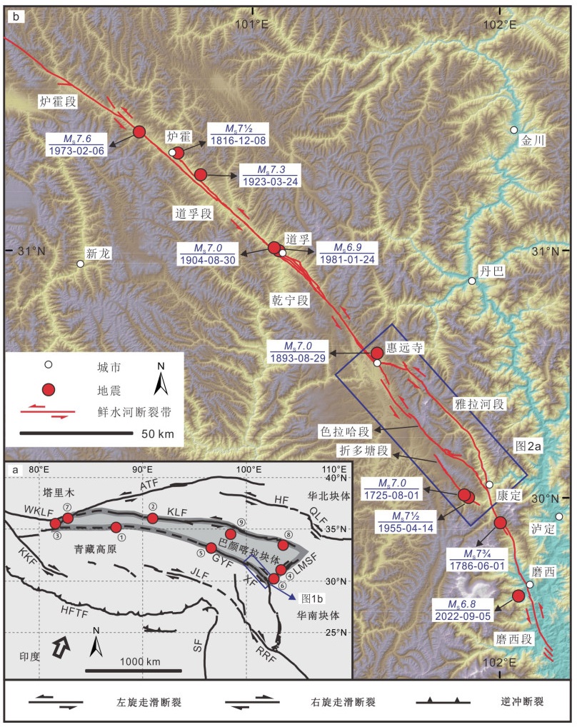
图 1 鲜水河断裂带活动构造简图
WKLF—西昆仑断裂;ATF—阿尔金断裂;HF—海原断裂;KLF—昆仑断裂;KKF—喀喇昆仑断裂;JLF—嘉黎断裂;GYF—甘孜-玉树断裂;XF—鲜水河断裂;LMSF—龙门山断裂;HFTF—喜马拉雅前缘逆冲断裂;SF—实皆断裂;RRF—红河断裂;QLF—秦岭断裂;①—1997年玛尼MS7.9地震;②—2001年昆仑MS8.1地震;③—2008年于田MS7.3地震;④—2008年汶川MS8.0地震;⑤—2010年玉树MS7.1地震;⑥—2013年芦山MS7.0地震;⑦—2014年于田MS7.3地震;⑧—2017年九寨沟MS7.0地震;⑨—2021年玛多MS7.4地震
a—巴颜喀拉块体周缘主要活动断裂及近年来主要强震(M ≥ 7)分布(据Tapponnier et al., 2001;邓起东等,2003;潘家伟等,2021修改);b—鲜水河断裂带几何展布及沿线主要强震分布Figure 1. Sketch map showing the active tectonics in the Xianshuihe fault zone
(a) Distribution of major active faults and large earthquakes (M≥7) surrounding the Bayan Har block in recent years (modified from Tapponnier et al., 2001; Deng et al., 2003; Pan et al., 2021); (b) Geometric distribution of the Xianshuihe fault zone and distribution of major strong earthquakes along it
WKLF-West Kunlun fault; ATF-Altyn Tagh fault; HF-Haiyuan fault; KLF-Kunlun fault; KKF-Karakorum fault; JLF-Jiali fault; GYF-Ganzi-Yushu fault; XF-Xianshuihe fault; LMSF-Longmenshan fault; HFTF-Himalayan frontal thrust fault; SF-Sagaing fault; RRF-Red river fault; QLF-Qinling fault; ①-1997 Mani MS7.9 earthquake; ②-2001 Kunlun MS8.1 earthquake; ③-2008 Yutian MS7.3 earthquake; ④-2008 Wenchuan MS8.0 earthquake; ⑤-2010 Yushu MS7.1 earthquake; ⑥-2013 Lushan MS7.0 earthquake; ⑦-2014 Yutian MS7.3 earthquake; ⑧-2017 Jiuzhaigou MS7.0 earthquake; ⑨-2021 Maduo MS7.4 earthquake
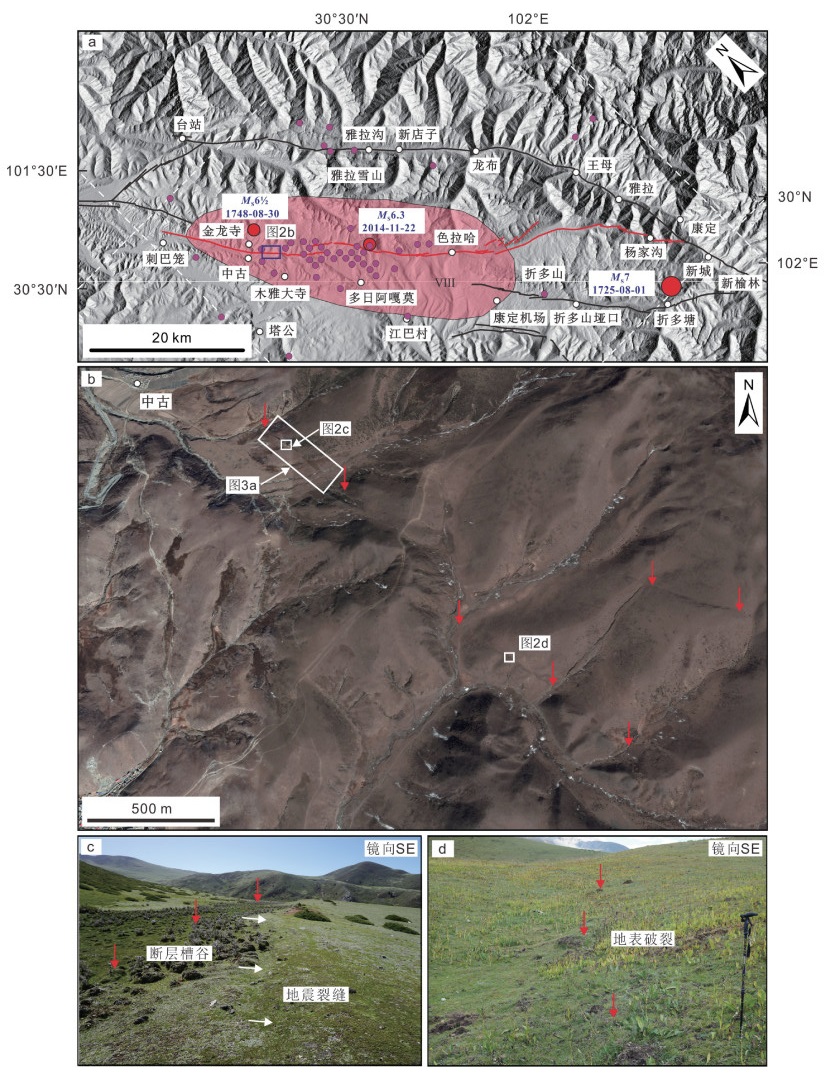
图 2 色拉哈段几何结构及中谷一带地震地表破裂分布
a—色拉哈段及邻区主要断层几何展布图,底图为山体阴影,紫色圆圈和粉色椭圆分别指示2014年康定MS6.3地震的余震分布(胡朝忠等,2015)和极震区(中国地震局,http://www.cea.gov.cn),Ⅷ为极震区地震烈度;b—中谷一带断层形迹,底图为Google Earth影像;c—断层槽谷及地震裂缝;d—地表破裂
Figure 2. Geometry of the Selaha fault and the distribution of seismic surface ruptures near the Zhonggu village
(a) Geometry distribution of the Selaha fault and major faults in the adjacent region, with hillshade map in the background. The purple circle and the pink oval are the aftershocks (Hu et al., 2015) and the seismic area (China Earthquake Administration, http://www.cea.gov.cn) of the Kangding MS6.3 earthquake, respectively. Ⅷ is the seismic intensity of the seismic area; (b) Fault traces near the Zhonggu village with Google Earth satellite image in the background; (c) Fault trough and seismic crack; (d) Surface rupture

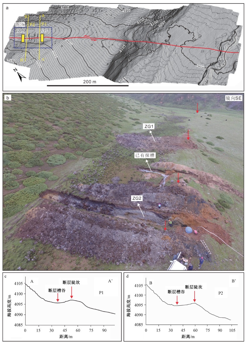
图 3 中谷探槽附近的断错地貌及探槽位置
a—中谷探槽及毗邻位置地形地貌,背景为无人机航拍获得的DEM图,红色线条为断层形迹,黄色小矩形框为探槽位置,黄色线条为地形剖面(P1、P2);b—中谷探槽及胡朝忠等(2015)探槽点处断错地貌与开挖后照片,红色箭头指向断层陡坎;c、d—地形剖面
Figure 3. Offset landforms near the Zhonggu trenches and the setting of the trenches
(a) Topography and landforms of the Zhonggu trenches and the adjacent region. The hillshade map is generated from an unmanned aerial vehicle-based digital elevation model; The red line represents the fault trace; The yellow rectangles and lines represent the trenches sites and topographic profiles (P1, P2), respectively; (b) Photo showing the offset landforms and the trenches in the Zhonggu site and the trench by Hu et al., 2015. The red arrows represent the fault scarps; (c and d) Topographic profiles across the fault scarps and trenches

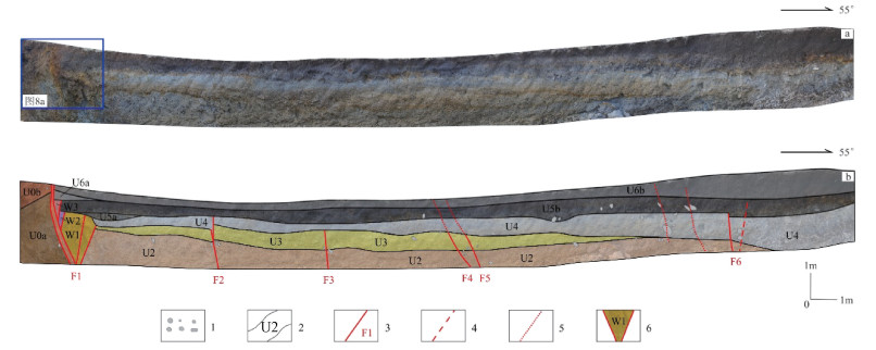
图 4 探槽ZG1北壁拼接图及剖面解译图
1—砾石;2—地层界线及单元;3—断层;4—推测断层;5—裂缝;6—构造楔
a—探槽ZG1北壁拼接图;b—剖面解译图Figure 4. Photomosaic and interpretation map of the northern wall of the trench ZG1
(a) Photomosaic; (b) Interpretation map
1-Gravel; 2-Stratigraphic boundary and unit; 3-Fault; 4-Inferred fault; 5-Crack; 6-Structural wedge
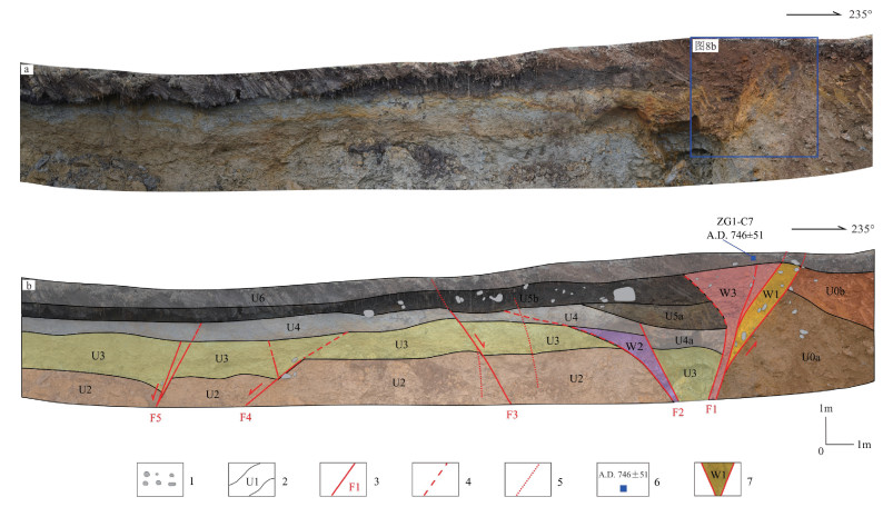
图 5 探槽ZG1南壁拼接图及剖面解译图
1—砾石;2—地层界线及单元;3—断层;4—推测断层;5—裂缝;6—样品位置及年龄;7—构造楔
a—探槽ZG1南壁拼接图;b—剖面解译图Figure 5. Photomosaic and interpretation map of the southern wall of the trench ZG1
(a) Photomosaic; (b) Interpretation map
1-Gravel; 2-Stratigraphic boundary and unit; 3-Fault; 4-Inferred fault; 5-Crack; 6-Sample location and age; 7-Structural wedge
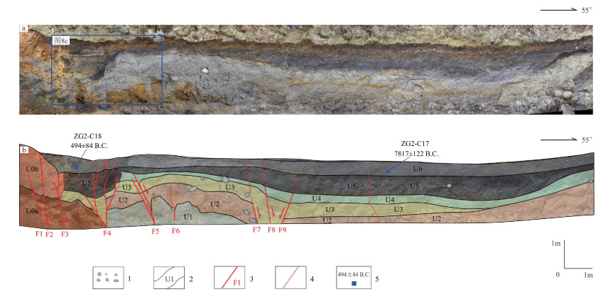
图 6 探槽ZG2北壁拼接图及剖面解译图
1—砾石;2—地层界线及单元;3—断层;4—裂缝;5—样品位置及年龄
a—探槽ZG2北壁拼接图;b—剖面解译图Figure 6. Photomosaic and interpretation map of the northern wall of the trench ZG2
(a) Photomosaic; (b) Interpretation map
1-Gravel; 2-Stratigraphic boundary and unit; 3-Fault; 4-Crack; 5-Sample location and age
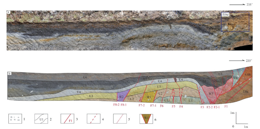
图 7 探槽ZG2南壁拼接图及剖面解译图
1—砾石;2—地层界线及单元;3—断层;4—推测断层;5—裂缝;6—构造楔
a—探槽ZG2南壁拼接图;b—剖面解译图Figure 7. Photomosaic and interpretation map of the southern wall of trench ZG2
(a) Photomosaic; (b) Interpretation map
1-Gravel; 2-Stratigraphic boundary and unit; 3-Fault; 4-Inferred fault; 5-Crack; 6-Structural wedge
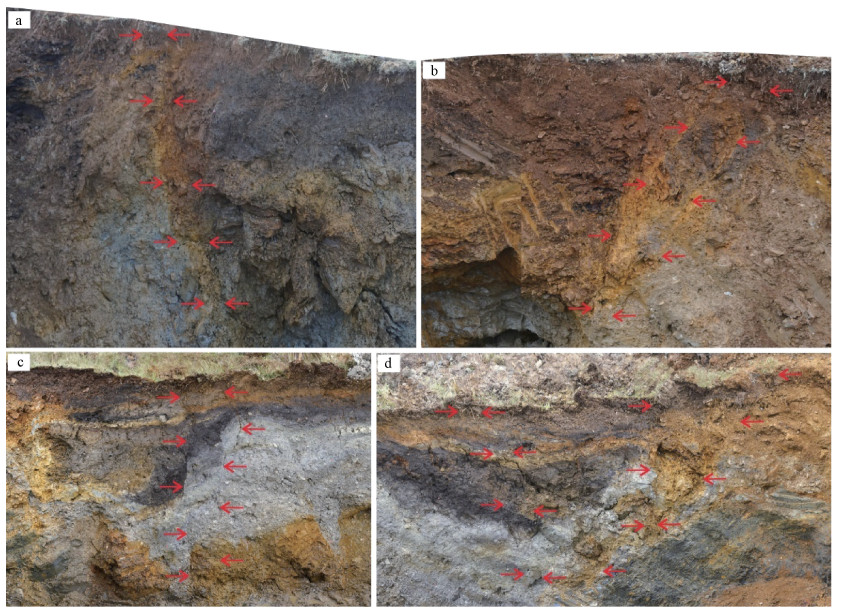
图 8 道孚中谷探槽剖面揭露的色拉哈段最新活动迹象
红色箭头指示断面或地震裂缝断错至地表
a—探槽ZG1北壁;b—探槽ZG1南壁;c—探槽ZG2北壁;d—探槽ZG2南壁Figure 8. Latest signs of activities in the Selaha segment revealed by the Zhonggu trench profiles
(a) The northern wall of the trench ZG1; (b) The southern wall of the trench ZG1; (c) The northern wall of the trench ZG2; (d) The southern wall of trench ZG2. Red arrows represent the fault planes or cracks that faulted to the surface
表 1 中谷探槽揭露的地层及其描述
Table 1. Units exposed by the Zhonggu trenches and their characteristics
地层编号 地层描述 U0 半风化基岩,上部呈褐棕—棕黄色(U0b),下部呈棕灰—棕灰绿色(U0a) U1 棕褐色砾块层,砾块磨圆度以棱角状—次棱角状为主,为风化—半风化粉砂质板岩的近源堆积 U2 青灰色略带灰绿色砂砾层,砾石磨圆较好,有一定分选,砾径以2~7 cm为主,为冰水堆积成因 U3 浅黄色含黏土粉砂层,底部含砾石,砾石有一定磨圆,略有分选,砾径约为2~5 cm,推测为冰水堆积夹杂近源堆积成因 U4 青灰色略带灰绿色砂砾层夹粉砂层,磨圆较好,具一定层理,应为冰水沉积成因 U5 中上部(U5b)为深褐—黝黑色砂质-粉砂质黏土层,局部堆积灰—深灰色砂黏土及浅褐黄色砂层,含砾石和植物根系,砾石磨圆差,有一定分选;底部(U5a)为沿局部洼坑堆积的灰白色或褐黄色砂砾层,砾石磨圆和分选差,砾径约为5~20 cm,仅在ZG1探槽中局部发育 U6 上部(U6b)为表层深褐色砂土,含较多植物根系;下部(U6a)为灰色—棕褐色砂土、黑土团块混杂堆积,底部含砾块  下载: 导出CSV
表 2 中谷探槽U6地层中放射性碳样品测试结果及其年代校正
Table 2. Radiocarbon ages and calibrated calendar ages of the samples in the U6 strata from the Zhonggu trenches
样品编号 测试材料 采样壁 测试年龄
(a B.P.)校正年龄 ZG1-C7 碳屑 ZG1南壁 1260±30 A.D.746±51 ZG2-C17 碳屑 ZG2北壁 8760±50 7817±122 B.C. ZG2-C18 半腐烂草屑 ZG2北壁 2400±30 494±84 B.C. 注:所有样品测年结果均由BETA实验室利用加速器质谱仪(AMS)测试完成
下载: 导出CSV
-
ALLEN C R, LUO Z L, QIAN H, et al., 1991. Field study of a highly active fault zone: the Xianshuihe fault of southwestern China[J]. GSA Bulletin, 103(9): 1178-1199. doi: 10.1130/0016-7606(1991)103<1178:FSOAHA>2.3.CO;2 AN Y F, 2010. Boundary features of the seismic rupture segments along the Xianshuihe fault zone[D]. Beijing: Institute of Geology, China Earthquake Administration. (in Chinese with English abstract) CHEN G H, XU X W, WEN X Z, et al., 2008. Kinematical transformation and slip partitioning of northern to eastern active boundary belt of Sichuan-Yunnan block[J]. Seismology and Geology, 30(1): 58-85. (in Chinese with English abstract) doi: 10.3969/j.issn.0253-4967.2008.01.005 CHEN G H, XU X W, WEN X Z, et al., 2016. Late quaternary slip-rates and slip partitioning on the southeastern Xianshuihe fault system, eastern Tibetan Plateau[J]. Acta Geologica Sinica (English Edition), 90(2): 537-554. doi: 10.1111/1755-6724.12689 CHENG J, XU X W, 2018. Features of earthquake clustering from calculation of coulomb stress around the Bayan Har block, Tibetan plateau[J]. Seismology and Geology, 40(1): 133-154. (in Chinese with English abstract) doi: 10.3969/j.issn.0253-4967.2018.01.011 DENG Q D, YU G H, YE W H, 1993. Relationship between earthquake magnitude and parameters of surface ruptures associated with historical earthquakes[M]//Editorial Board of Active Fault Research. Research of Active Fault (2). Beijing: Seismological Press: 247-264. (in Chinese) DENG Q D, ZHANG P Z, RAN Y K, et al., 2003. Active tectonics and earthquake activities in China[J]. Earth Science Frontiers, 10(S1): 66-73. (in Chinese with English abstract) DENG Q D, GAO X, CHEN G H, et al., 2010. Recent tectonic activity of Bayankala fault-block and the Kunlun-Wenchuanearthquake series of the Tibetan Plateau[J]. Earth Science Frontiers, 17(5): 163-178. (in Chinese with English abstract) DENG Q D, CHENG S P, MA J, et al., 2014. Seismic activities and earthquake potential in the Tibetan Plateau[J]. Chinese Journal of Geophysics, 57(7): 2025-2042. (in Chinese with English abstract) Department of Earthquake Disaster Prevention, State Seismological Bureau, 1995. Catalogue of historical strong earthquakes in China (23rd Century B. C. to 1911)[M]. Beijing: Seismological Press: 1-514. (in Chinese) GUO R M, ZHENG Y, TIAN W, et al., 2018. Locking status and earthquake potential hazard along the middle-south Xianshuihe fault[J]. Remote Sensing, 10(12): 2048. doi: 10.3390/rs10122048 HU C Z, YANG P X, LIANG P, et al., 2015. The Holocene paleoearthquakes on the 2014 Kangding Ms6.3 earthquake faults[J]. Chinese Science Bulletin, 60(23): 2236-2244. (in Chinese with English abstract) doi: 10.1360/N972014-01271 JIANG G Y, WEN Y M, LIU Y J, et al., 2015. Joint analysis of the 2014 Kangding, southwest China, earthquake sequence with seismicity relocation and InSAR inversion[J]. Geophysical Research Letters, 42(9): 3273-3281, doi: 10.1002/2015GL063750. LI D Y, CHEN L C, LIANG M J, et al., 2017. Holocene palaeoseismologic record and rupture behavior of large earthquakes on the Xianshuihe fault[J]. Seismology and Geology, 39(4): 623-643. (in Chinese with English abstract) doi: 10.3969/j.issn.0253-4967.2017.04.001 LI T S, DU Q F, YOU Z L, et al., 1997. The active Xianshuihe fault zone and seismic risk assessment[M]. Chengdu: Cartographic Publishing House of Chengdu: 1-230. (in Chinese) LIANG M J, CHEN L C, RAN Y K, et al., 2020. Late-Quaternary activity of the Yalahe fault of the Xianshuihe fault zone, eastern margin of the Tibet Plateau[J]. Seismology and Geology, 42(2): 513-525. (in Chinese with English abstract) doi: 10.3969/j.issn.0253-4967.2020.02.016 LIU J, XU X W, LI Y F, et al., 2007. On the completeness of paleoseismic records of strike-slip faults: an example from the Laohushan segment of the Haiyuan fault in Gansu, China, with a discussion of several problems in the paleoearthquake study[J]. Geological Bulletin of China, 26(6): 650-660. (in Chinese with English abstract) doi: 10.3969/j.issn.1671-2552.2007.06.004 LONG D X, DENG T G, 1991. A discussion on the statutory of the 1725 Kangding earthquake with M=7.5[J]. Earthquake Research in Sichuan(1): 37-44. (in Chinese with English abstract) MENG Q, GAO K, CHEN Q Z, et al., 2021. Seismogenic, coseismic and postseismic deformation and stress evolution of the 2008 Wenchuan earthquake: Numerical simulation analysis[J]. Journal of Geomechnics, 27(4): 614-627. (in Chinese with English abstract) PARSONS T, JI C, KIRBY E, 2008. Stress changes from the 2008 Wenchuan earthquake and increased hazard in the Sichuan basin[J]. Nature, 454(7203): 509-510. doi: 10.1038/nature07177 PAN J W, BAI M K, LI C, et al., 2021. Coseismic surface rupture and seismogenic structure of the 2021-05-22 Maduo (Qinghai) Ms7.4 earthquake[J]. Acta Geologica Sinica, 95(6): 1655-1670. (in Chinese with English abstract) doi: 10.3969/j.issn.0001-5717.2021.06.001 RAN Y K, WANG H, LI Y B, et al., 2012. Key techniques and several cases analysis in paleoseismic studies in mainland China (1): trenching sites, layouts and paleoseismic indicators on active strike-slip faults[J]. Seismology and Geology, 34(2): 197-210. (in Chinese with English abstract) RAN Y K, WANG H, YANG H L, et al., 2014. Key techniques and several cases analysis in paleoseismic studies in mainland China (4): sampling and event analysis of paleoseismic dating methods[J]. Seismology and Geology, 36(4): 939-955. (in Chinese with English abstract) doi: 10.3969/j.issn.0253-4967.2014.04.001 SHAN B, XIONG X, ZHENG Y, et al., 2009. Stress changes on major faults caused by Mw 7.9 Wenchuan earthquake, May 12, 2008[J]. Science in China Series D: Earth Sciences, 52(5): 593-601. doi: 10.1007/s11430-009-0060-9 TAPPONNIER P, XU Z Q, ROGER F, et al., 2001. Oblique stepwise rise and growth of the Tibet Plateau[J]. Science, 294(5547): 1671-1677. doi: 10.1126/science.105978 TODA S, LIN J, MEGHRAOUI M, et al., 2008. 12 May 2008 M= 7.9 Wenchuan, China, earthquake calculated to increase failure stress and seismicity rate on three major fault systems[J]. Geophysical Research Letters, 35(17): L17305, doi: 10.1029/2008GL034903. WANG X M, PEI X Y, 1988. Some new points of view on the 1786 earthquake (M=73/4) occurring in the area between Kangding and Moxi, Luding, Sichuan Province[J]. Earthquake Research in China, 4(1): 108-115. (in Chinese with English abstract) WANG X M, PEI X Y, 1998. Active faults and co-seismic cracks in the Kangding-Luding area[J]. Earthquake Research in Sichuan(1-2): 46-56. (in Chinese with English abstract) WELLS D L, COPPERSMITH K J, 1994. New empirical relationships among magnitude, rupture length, rupture width, rupture area, and surface displacement[J]. Bulletin of the Seismological Society of America, 84(4): 974-1002. WEN X Z, ALLEN C R, LUO Z L, et al., 1989. Segmentation, geometric features, and their seismotectonic implications for the Holo-cene Xianshuihe fault Zone[J]. Acta Seismologica Sinica, 11(4): 362-372. (in Chinese with English abstract) WEN X Z, 1995. Quantitative estimates of seismic potential on active faults[M]. Beijing: Seismological Press: 1-150. (in Chinese) WEN X Z, MA S L, XU X W, et al., 2008. Historical pattern and behavior of earthquake ruptures along the eastern boundary of the Sichuan-Yunnan faulted-block, southwestern China[J]. Physics of the Earth and Planetary Interiors, 168(1-2): 16-36. doi: 10.1016/j.pepi.2008.04.013 WEN X Z, ZHANG P Z, DU F, et al., 2009. The background of historical and modern seismic activities of the occurrence of the 2008 Ms8.0 Wenchuan, Sichuan, earthquake[J]. Chinese Journal of Geophysics, 52(2): 444-454. (in Chinese with English abstract) WEN X Z, 2018. The 2008 Wenchuan, 2013 Lushan and 2017 Jiuzhaigou earthquakes, Sichuan, in the last more than one thousand years of rupture history of the eastern margin of the Bayan Har block[J]. Acta Seismologica Sinica, 40(3): 4-16. (in Chinese with English abstract) WESNOUSKY S G, 2008. Displacement and geometrical characteristics of earthquake surface ruptures: issues and implications for seismic-hazard analysis and the process of earthquake rupture[J]. Bulletin of the Seismological Society of America, 98(4): 1609-1632. doi: 10.1785/0120070111 XU X W, DENG Q D, 1996. Nonlinear characteristics of paleoseismicity in China[J]. Journal of Geophysical Research: Solid Earth, 101(B3): 6209-6231. doi: 10.1029/95JB01238 YI G X, FAN J, WEN X Z, 2005. Study on faulting behavior and fault-segments for potential strong earthquake risk along the central-southern segment of Xianshuihe fault zone based on current seismicity[J]. Earthquake, 25(1): 58-66. (in Chinese with English abstract) YI G X, LONG F, WEN X Z, et al., 2015. Seismogenic structure of the M6.3 Kangding earthquake sequence on 22 Nov. 2014, Southwestern China[J]. Chinese Journal of Geophysics, 58(4): 1205-1219. (in Chinese with English abstract) ZHAN Y, LIANG M J, SUN X Y, et al., 2021. Deep structure and seismogenic pattern of the 2021.5.22 Madoi(Qinghai) Ms7.4 earthquake[J]. Chinese Journal of Geophysics, 64(7): 2232-2252. (in Chinese with English abstract) ZHOU R J, HE Y L, HUANG Z Z, et al., 2001a. The slip rate and strong earthquake recurrence interval on the Qianning-Kangding segment of the Xianshuihe fault zone[J]. Acta Seismologica Sinica, 23(3): 250-261. (in Chinese with English abstract) ZHOU R J, HE Y L, YANG T, et al., 2001b. Slip rate and strong earthquake rupture on the Moxi-Mianning segment along the Xianshuihe-Anninghe fault zone[J]. Earthquake Research in China, 17(3): 253-262. (in Chinese with English abstract) 安艳芬, 2010. 鲜水河断裂带地震破裂段落的边界特征研究[D]. 北京: 中国地震局地质研究所. 陈桂华, 徐锡伟, 闻学泽, 等, 2008. 川滇块体北-东边界活动构造带运动学转换与变形分解作用[J]. 地震地质, 30(1): 58-85. https://www.cnki.com.cn/Article/CJFDTOTAL-DZDZ200801005.htm 程佳, 徐锡伟, 2018. 巴颜喀拉块体周缘强震间应力作用与丛集活动特征初步分析[J]. 地震地质, 40(1): 133-154. https://www.cnki.com.cn/Article/CJFDTOTAL-DZDZ201801011.htm 邓起东, 于贵华, 叶文华, 1993. 地震地表破裂参数与震级关系的研究[M]//《活动断裂研究》编委会. 活动断裂研究(2). 北京: 地震出版社: 247-264. 邓起东, 张培震, 冉勇康, 等, 2003. 中国活动构造与地震活动[J]. 地学前缘, 10(S1): 66-73. https://www.cnki.com.cn/Article/CJFDTOTAL-DXQY2003S1011.htm 邓起东, 高翔, 陈桂华, 等, 2010. 青藏高原昆仑-汶川地震系列与巴颜喀喇断块的最新活动[J]. 地学前缘, 17(5): 163-178. https://www.cnki.com.cn/Article/CJFDTOTAL-DXQY201005017.htm 邓起东, 程绍平, 马冀, 等, 2014. 青藏高原地震活动特征及当前地震活动形势[J]. 地球物理学报, 57(7): 2025-2042. https://www.cnki.com.cn/Article/CJFDTOTAL-DQWX201407001.htm 国家地震局震害防御司, 1995. 中国历史强震目录(公元前23世纪—公元1911年). 北京: 地震出版社: 1-514. 胡朝忠, 杨攀新, 梁朋, 等, 2015. 2014年康定Ms6.3级地震发震断裂的古地震[J]. 科学通报, 60(23): 2236-2244. https://www.cnki.com.cn/Article/CJFDTOTAL-KXTB201523010.htm 李东雨, 陈立春, 梁明剑, 等, 2017. 鲜水河断裂带乾宁段古地震事件与大震复发行为[J]. 地震地质, 39(4): 623-643. https://www.cnki.com.cn/Article/CJFDTOTAL-DZDZ201704001.htm 李天祒, 杜其方, 游泽李, 等, 1997. 鲜水河活动断裂带及强震危险性评估[M]. 成都: 成都地图出版社: 1-230. 梁明剑, 陈立春, 冉勇康, 等, 2020. 鲜水河断裂带雅拉河段晚第四纪活动性[J]. 地震地质, 42(2): 513-525. https://www.cnki.com.cn/Article/CJFDTOTAL-DZDZ202002017.htm 刘静, 徐锡伟, 李岩峰, 等, 2007. 以海原断裂甘肃老虎山段为例浅析走滑断裂古地震记录的完整性: 兼论古地震研究中的若干问题[J]. 地质通报, 26(6): 650-660. https://www.cnki.com.cn/Article/CJFDTOTAL-ZQYD200706004.htm 龙德雄, 邓天岗, 1991. 1725年康定7 1/2级地震发震构造问题的讨论[J]. 四川地震(1): 37-44. https://www.cnki.com.cn/Article/CJFDTOTAL-SCHZ199101006.htm 孟秋, 高宽, 陈启志, 等, 2021. 2008年汶川大地震孕震、同震及震后变形和应力演化全过程的数值模拟[J]. 地质力学学报, 27(4): 614-627. doi: 10.12090/j.issn.1006-6616.2021.27.04.051 潘家伟, 白明坤, 李超, 等, 2021. 2021年5月22日青海玛多Ms7.4地震地表破裂带及发震构造[J]. 地质学报, 95(6): 1655-1670. https://www.cnki.com.cn/Article/CJFDTOTAL-DZXE202106001.htm 冉勇康, 王虎, 李彦宝, 等, 2012. 中国大陆古地震研究的关键技术与案例解析(1): 走滑活动断裂的探槽地点、布设与事件识别标志[J]. 地震地质, 34(2): 197-210. https://www.cnki.com.cn/Article/CJFDTOTAL-DZDZ201202002.htm 冉勇康, 王虎, 杨会丽, 等, 2014. 中国大陆古地震研究的关键技术与案例解析(4): 古地震定年技术的样品采集和事件年代分析[J]. 地震地质, 36(4): 939-955. https://www.cnki.com.cn/Article/CJFDTOTAL-DZDZ201404001.htm 王新民, 裴锡瑜, 1988. 对1786年康定-泸定磨西间73/4级级地震的新认识[J]. 中国地震, 4(1): 108-115. https://www.cnki.com.cn/Article/CJFDTOTAL-ZGZD198801018.htm 王新民, 裴锡瑜, 1998. 康定-泸定地区主要活断层与地震裂缝[J]. 四川地震(1-2): 46-56. https://www.cnki.com.cn/Article/CJFDTOTAL-SCHZ8Z1.002.htm 闻学泽, ALLEN C R, 罗灼礼, 等, 1989. 鲜水河全新世断裂带的分段性、几何特征及其地震构造意义[J]. 地震学报, 11(4): 362-372. https://www.cnki.com.cn/Article/CJFDTOTAL-DZXB198904002.htm 闻学泽, 1995. 活动断裂地震潜势的定量评估[M]. 北京: 地震出版社: 1-150. 闻学泽, 张培震, 杜方, 等, 2009. 2008年汶川8.0级地震发生的历史与现今地震活动背景[J]. 地球物理学报, 52(2): 444-454. https://www.cnki.com.cn/Article/CJFDTOTAL-DQWX200902017.htm 闻学泽, 2018. 巴颜喀拉块体东边界千年破裂历史与2008年汶川、2013年芦山和2017年九寨沟地震[J]. 地震学报, 40(3): 4-16. https://www.cnki.com.cn/Article/CJFDTOTAL-DZXB201803002.htm 易桂喜, 范军, 闻学泽, 2005. 由现今地震活动分析鲜水河断裂带中-南段活动习性与强震危险地段[J]. 地震, 25(1): 58-66. https://www.cnki.com.cn/Article/CJFDTOTAL-DIZN200501008.htm 易桂喜, 龙锋, 闻学泽, 等, 2015. 2014年11月22日康定M6.3级地震序列发震构造分析[J]. 地球物理学报, 58(4): 1205-1219. https://www.cnki.com.cn/Article/CJFDTOTAL-DQWX201504010.htm 詹艳, 梁明剑, 孙翔宇, 等, 2021. 2021年5月22日青海玛多Ms7.4地震深部环境及发震构造模式[J]. 地球物理学报, 64(7): 2232-2252. https://www.cnki.com.cn/Article/CJFDTOTAL-DQWX202107002.htm 周荣军, 何玉林, 黄祖智, 等, 2001a. 鲜水河断裂带乾宁-康定段的滑动速率与强震复发间隔[J]. 地震学报, 23(3): 250-261. https://www.cnki.com.cn/Article/CJFDTOTAL-DZXB200103003.htm 周荣军, 何玉林, 杨涛, 等, 2001b. 鲜水河-安宁河断裂带磨西-冕宁段的滑动速率与强震位错[J]. 中国地震, 17(3): 253-262. https://www.cnki.com.cn/Article/CJFDTOTAL-ZGZD200103003.htm -

 下载:
下载:

计量
- 文章访问数: 1434
- HTML全文浏览量: 554
- PDF下载量: 119
- 被引次数: 0
