

InSAR-based indentification and spatial distribution analysis of active landslides in the Western Sichuan Plateau
-
摘要: 成都平原向西至松潘−甘孜褶皱带完成了从平原到高山峡谷区的转变,区域内起伏落差巨大,地势奇峻,河流下切侵蚀严重,构造活动频繁,地震频发,内外动力作用强烈,地质灾害众多。文章利用覆盖全区的Sentinel-1A升降轨数据以及重点区域的ALOS-2数据进行InSAR技术处理,结合GIS空间分析,对研究区活动性滑坡进行早期识别以及空间分布规律的探索,再辅以部分野外调查佐证,获得了以下认识:研究区滑坡集中分布地区按其诱因可分为水库蓄水诱发灾害区(黑水县毛尔盖水库)、震后破碎山体灾害区(茂县岷江与黑水沟交界、汶川至理县一带、九寨沟至石鸡坝镇一线)和重要河流灾害区(舟曲、腊子口镇、小金县和丹巴县);区域内活动性滑坡主要分布于千枚岩等变质岩和泥页岩等碎屑岩中;主要地形范围为坡向南东、东、北东向,坡度15°~40°,高程区间1000~3000 m,相对高差>1000 m;主要分布断裂有岷江断裂、玛曲−荷叶断裂、光盖山−迭山北麓断裂和茂汶−汶川断裂。Sentinel-1A升降轨数据的结合,使得有效观测区域提高到研究区面积的73.41%。在川西高原区ALOS-2数据相对优于Sentinel-1A数据,ALOS-2和Sentinel-1A数据在九寨沟和茂县重叠区识别的结果重合率为58.7%和44.8%,识别数量前者分别是后者的3.98倍和1.39倍。Abstract: The Chengdu plain westward to the Songpan-Ganzi fold belt is a transition zone from basin to plateau. The region has huge undulation and fall, strange and steep terrain, severe river undercutting and erosion, frequent tectonic activities, and strong internal and external dynamics, resulting in frequent earthquakes and numerous geological hazards. The article uses Sentinel-1A data covering the whole region and ALOS-2 data in key areas for InSAR technology processing, combined with GIS spatial analysis, early identification of active landslide disasters in the study area and exploration of spatial distribution patterns, supplemented by field surveys to support the following understanding. According to the inducing factors of the disaster, the areas where the disaster points are concentrated can be divided into three zones: disaster zones induced by reservoir storage, such as Maoergai Reservoir in Heishui County; disaster zones caused by broken mountains after the earthquake, such as the junction of Minjiang River and Heishui Gully in Maoxian County, the area from Wenchuan County to Li County, and the area from Jiuzhaigou County to Shijiba Town; disaster zones cause by essential rivers, such as Zhouqu County, Lazikou Town, Xiaojin County, and Danba County. The active landslides in the region are mainly distributed in metamorphic rocks such as phyllite and clastic rocks such as shale. The disasters are mainly distributed in the terrain with aspects of SE, E, NE, slope greater than 15°, elevation interval of 1000~3000 m, relative elevation difference greater than 1000 m, and curvature between −0.5~0.5. The disaster points are mainly close to the Minjiang fault, the Tazang fault, the Guanggaishan-Northern Dieshan fault, and the Maowen-Wenchuan fault zone. The combination of orbit-ascending and orbit-ascending data of Sentinel-1A increases the effective observation area to 73.41% of the total area. The ALOS-2 data are relatively better than the Sentinel-1A data in the western Sichuan plateau area. The coincidence rates of ALOS-2 and Sentinel-1A are 58.7% and 44.8%, respectively, in Jiuzhaigou and Maoxian, and the identified number of the former is 3.98 times and 1.39 times that of the latter.
-
Key words:
- Western Sichuan Plateau /
- fault /
- landslide /
- InSAR /
- GIS /
- geohazards
-
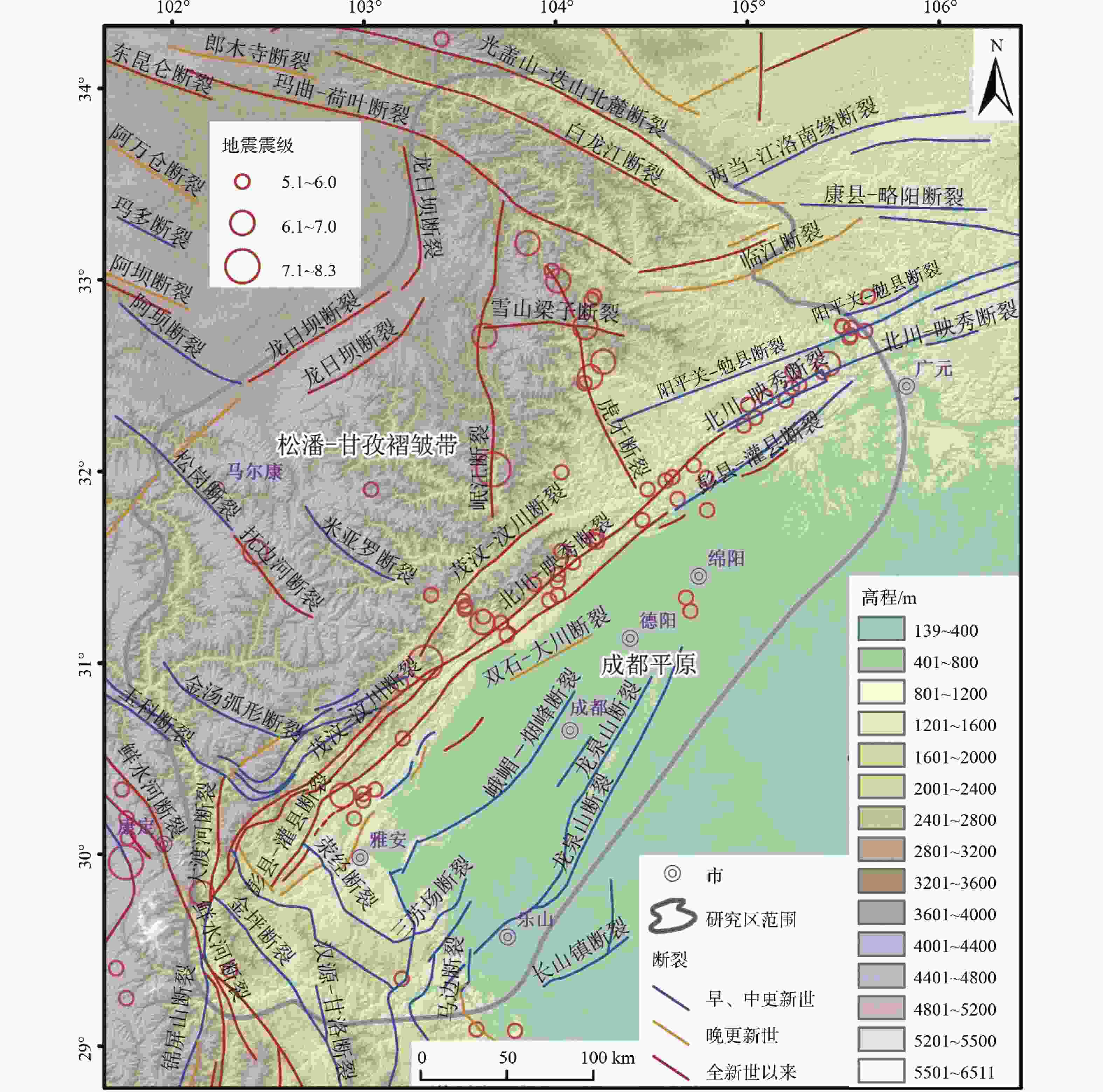
图 1 研究区及其周边地形地貌、活动断裂及MS 5.0级以上地震分布图
Figure 1. Map showing the surrounding topography , active faults and earthquakes(≥MS 5.0) in the study area
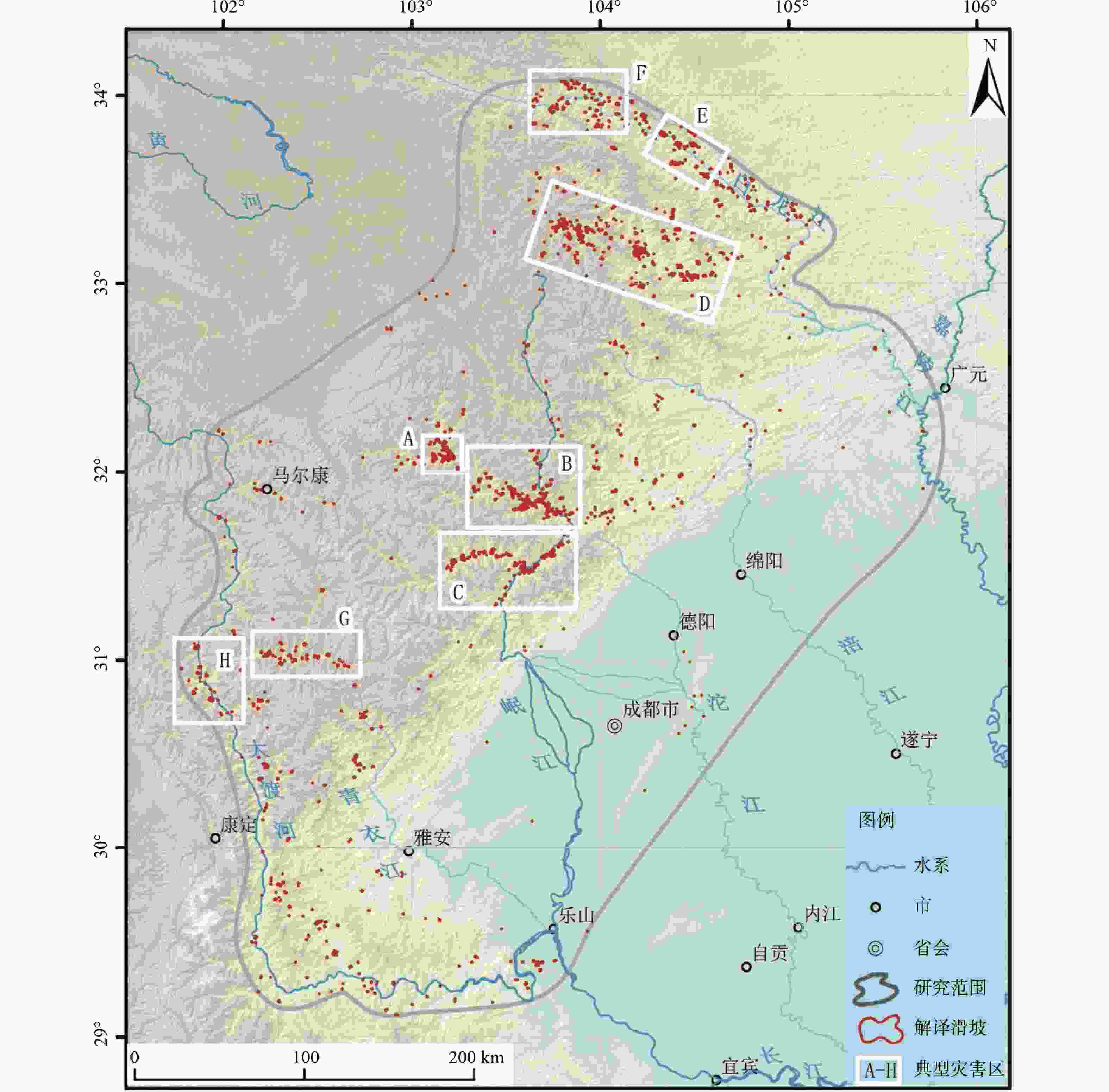
图 4 依据InSAR地表形变结果解译的活动性滑坡分布图
Figure 4. Distribution of active landslides interpreted by the InSAR technology

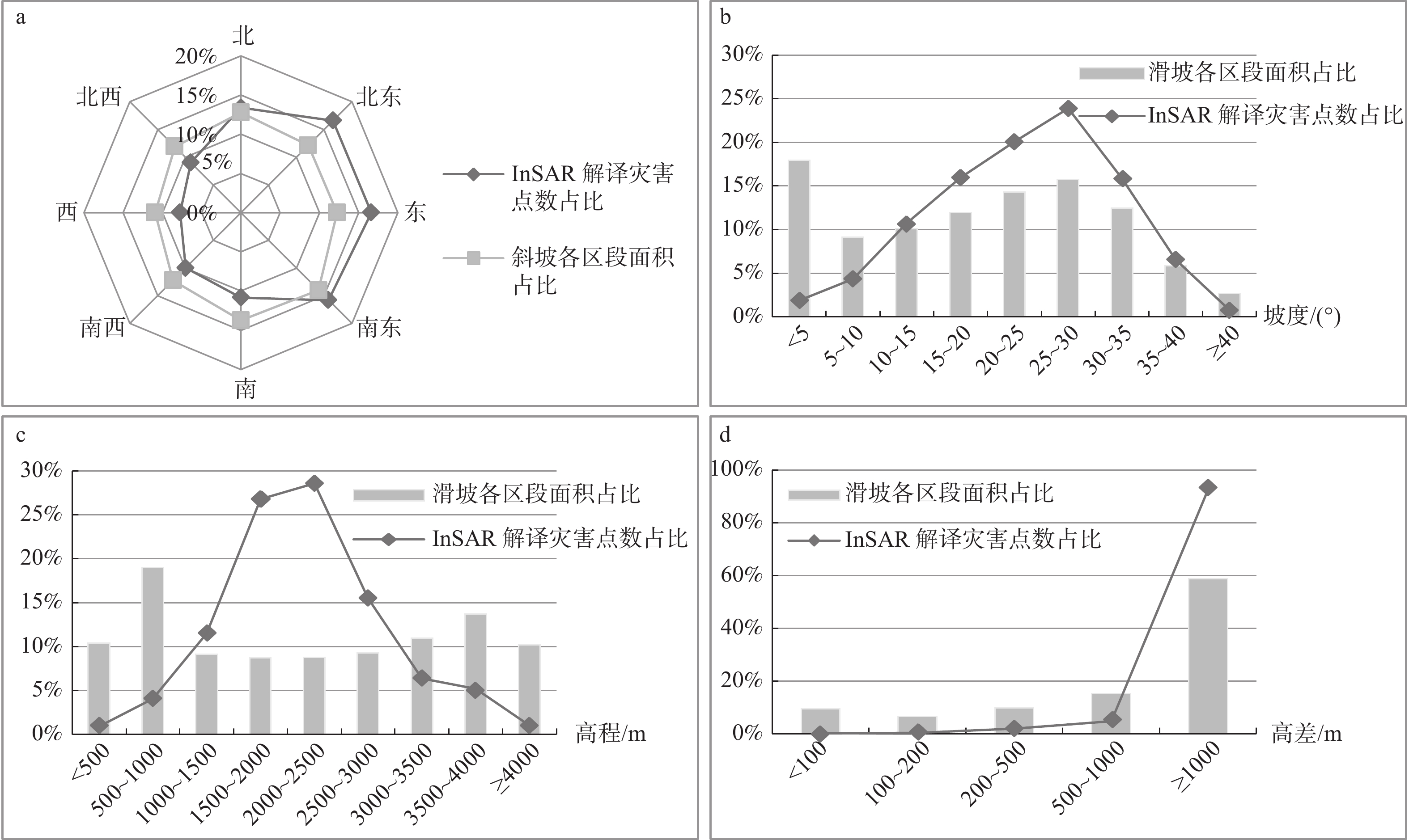
图 5 解译滑坡地貌因子统计
a—坡向;b—坡度;c—高程;d—滑坡相对高差
Figure 5. Statistics of geomorphologic factors of interpreted landslides
(a) Aspect ; (b) Slope ; (c) Elevation ; (d) Relative height
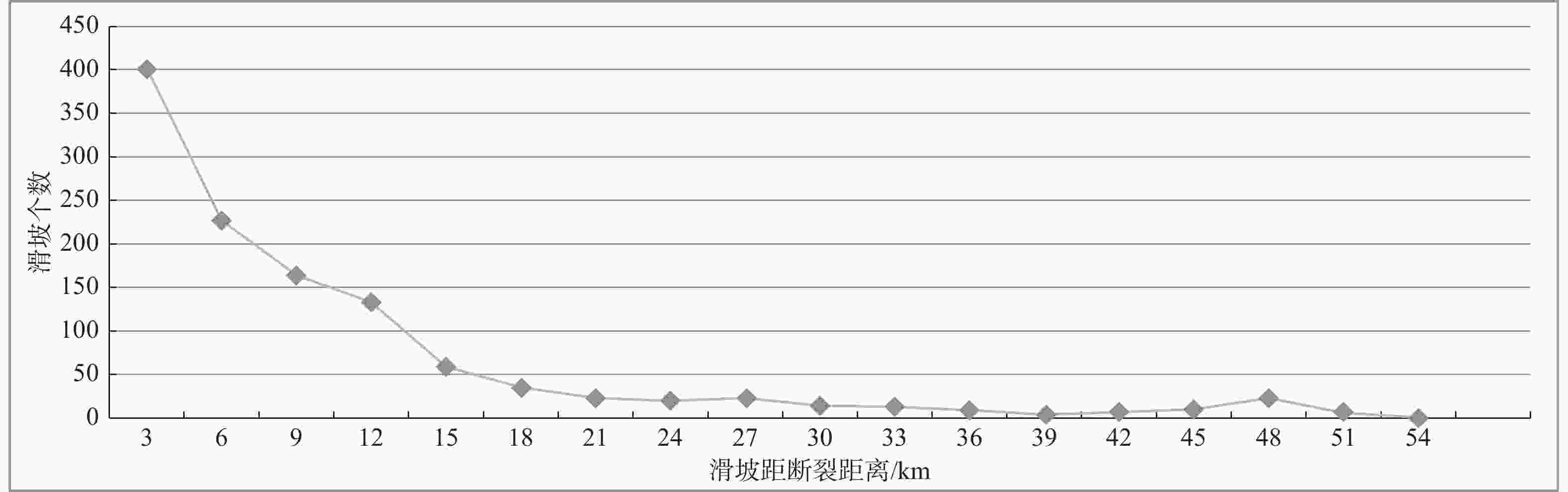
图 6 解译滑坡与相邻断裂距离统计分析
Figure 6. Statistics of distance between landslide points and adjacent fractures
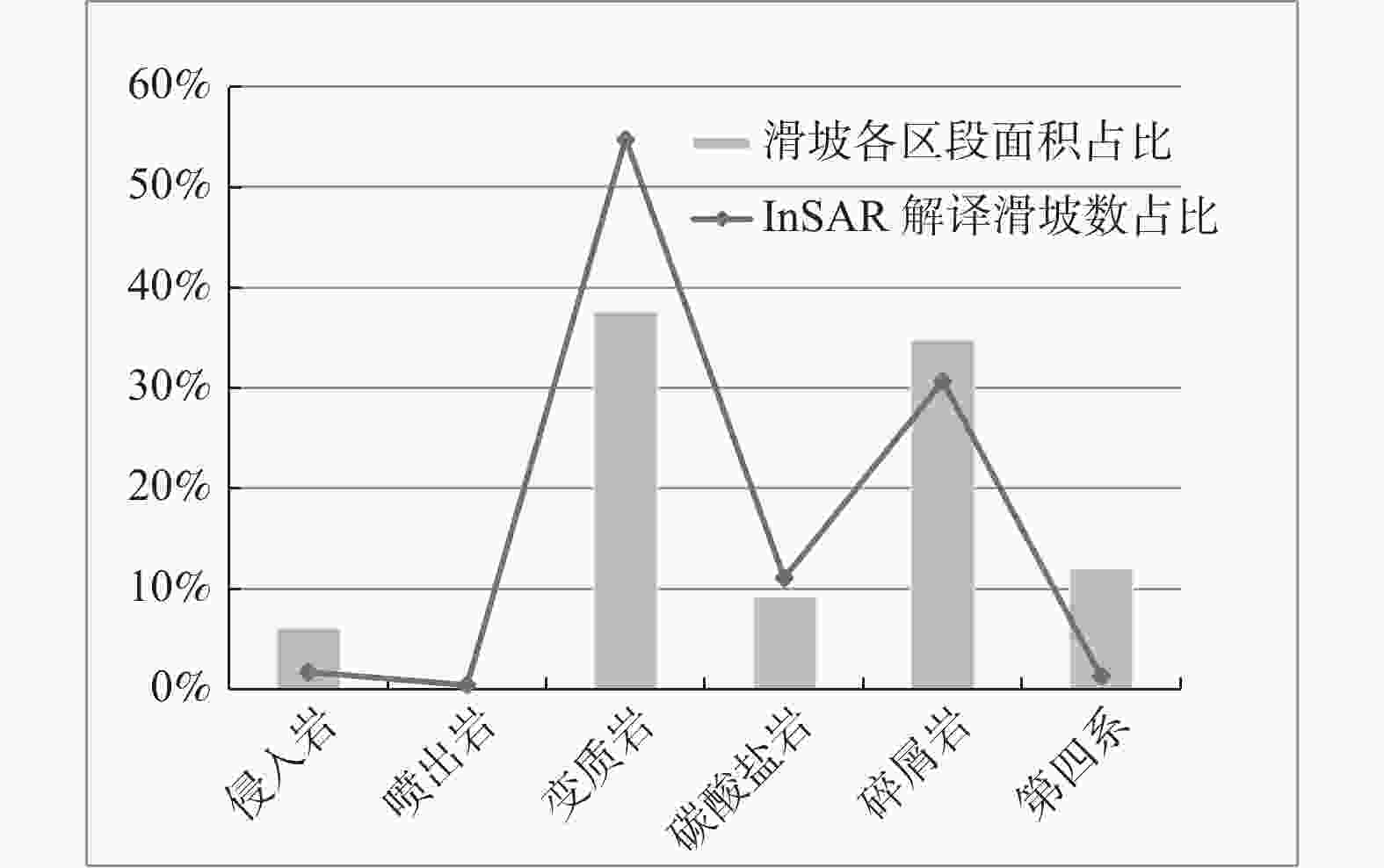
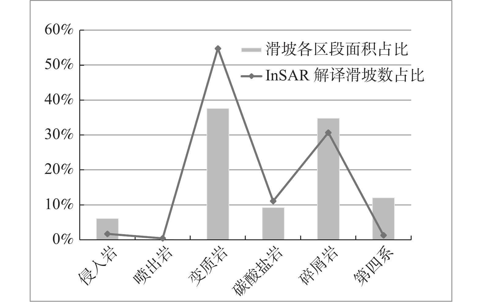
图 7 解译滑坡地层岩性统计
Figure 7. Statistical analysis of formation lithology of interpreted landslides
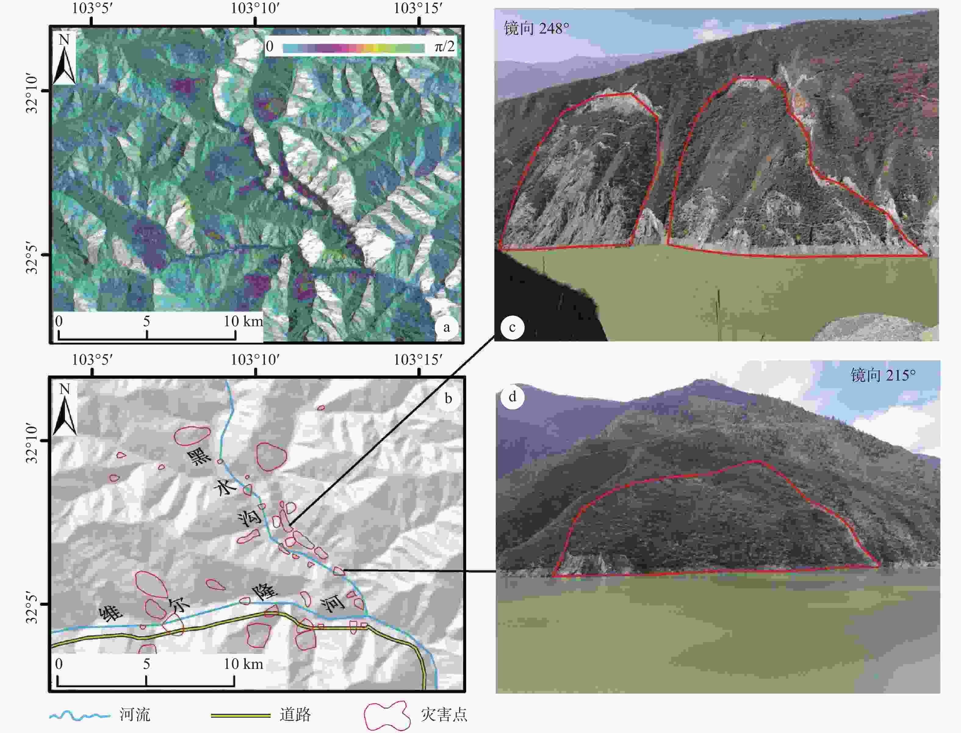
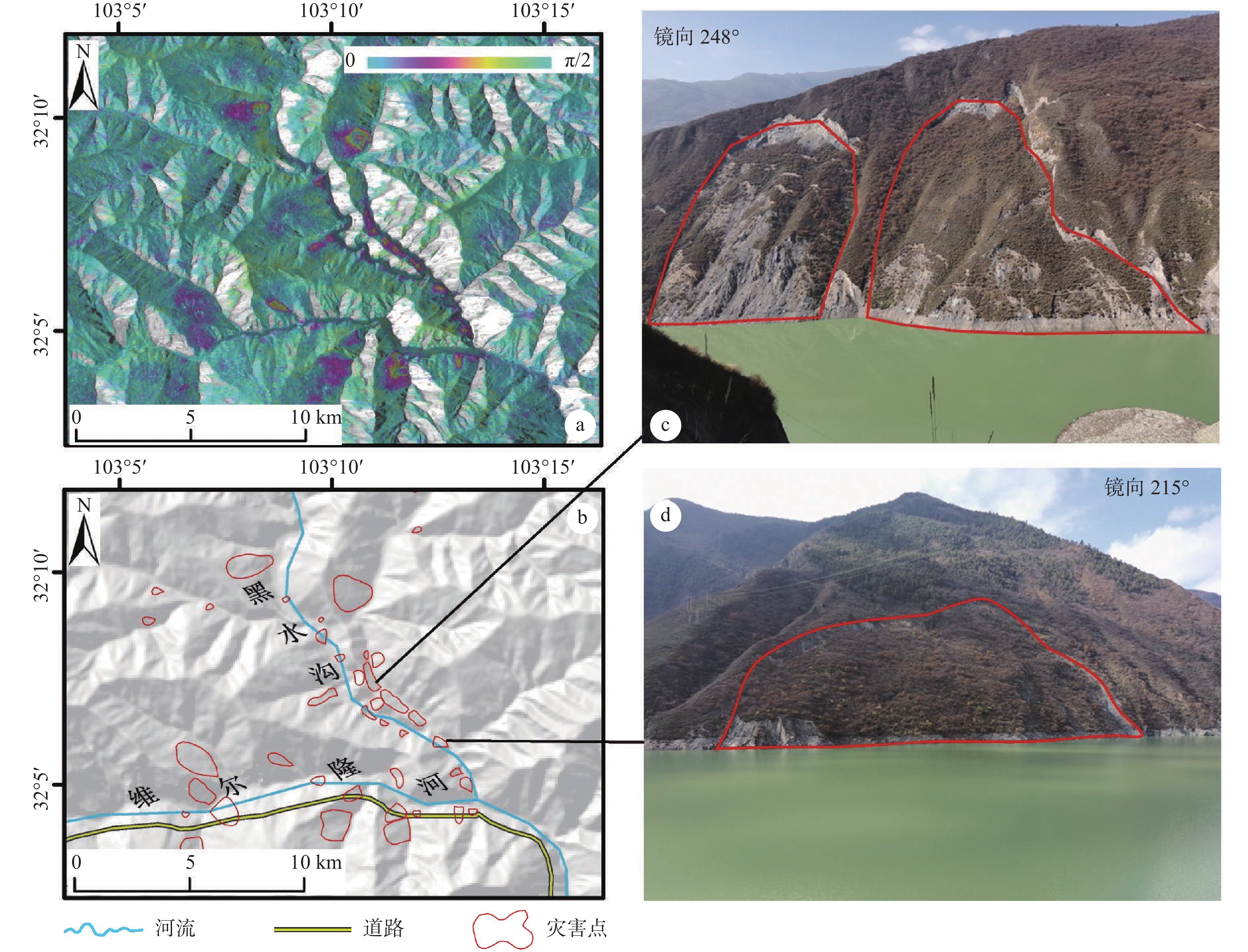
图 8 A区滑坡分布及野外典型照片
a—InSAR变形图;b—解译结果图;c、d—野外典型照片
Figure 8. Distribution map of landslides and typical field photos of Zone A
(a) InSAR-observed deformation map; (b) Distribution map of landslides; (c and d) Typical field photos
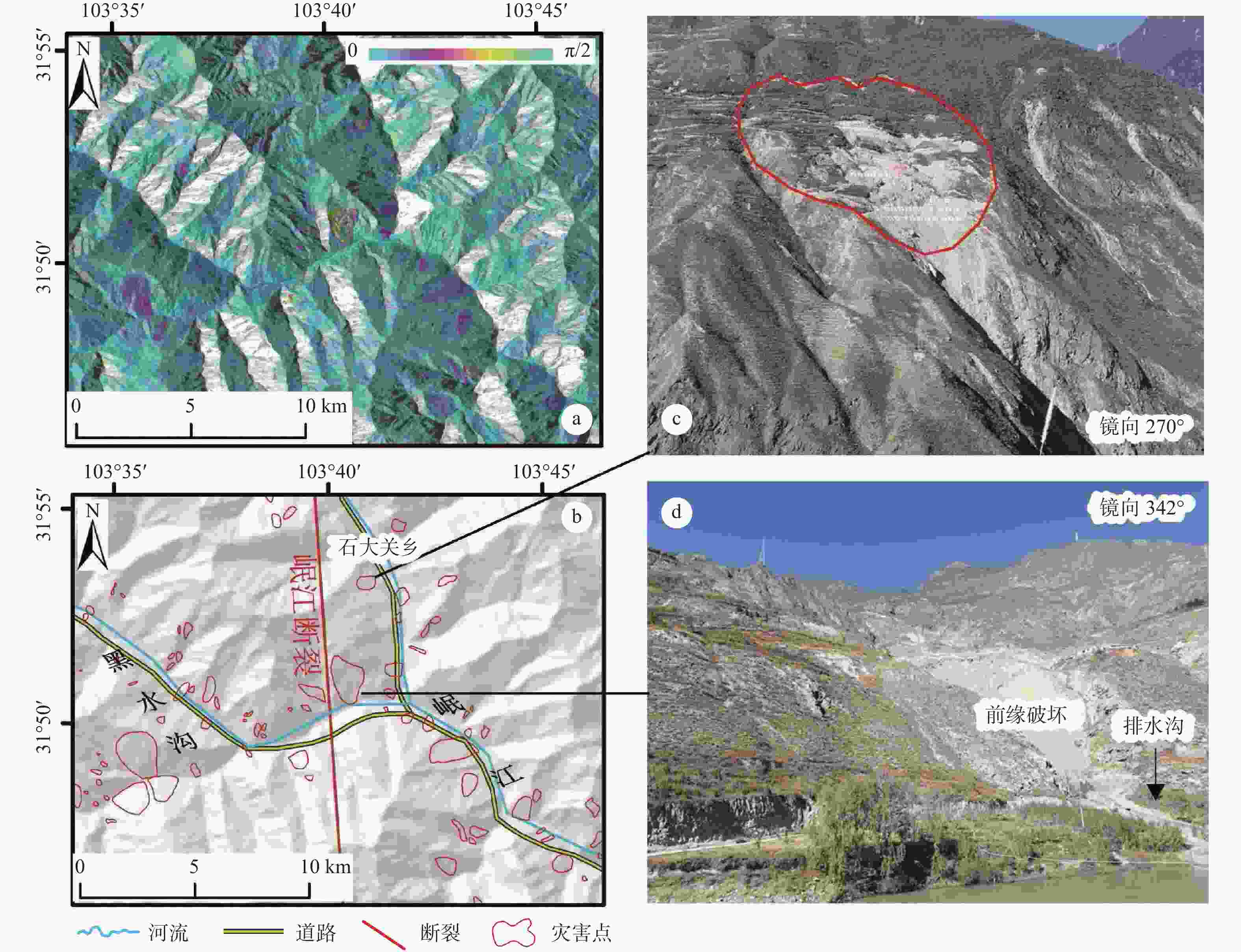
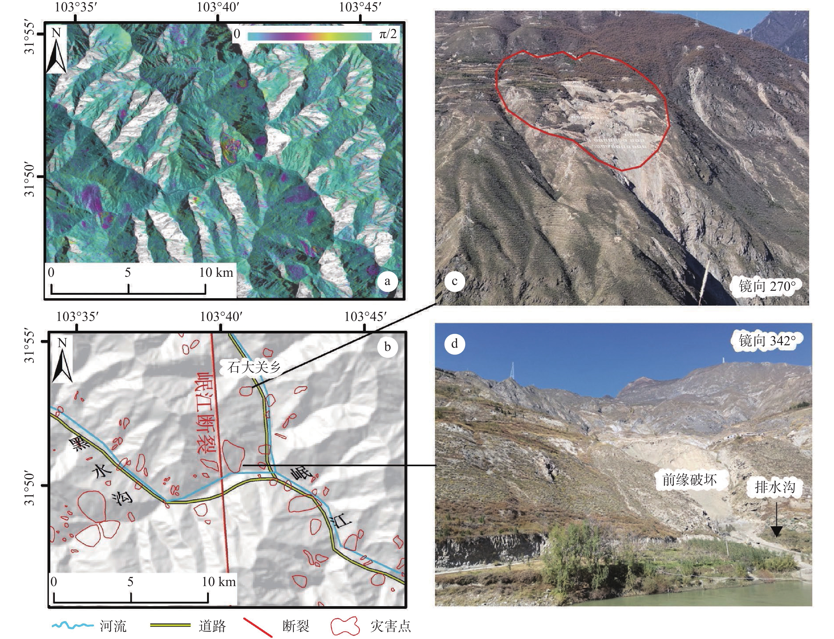
图 9 B区滑坡分布及野外典型照片
a—InSAR变形图;b—解译结果图;c、d—野外典型照片
Figure 9. Distribution map of landslides and typical field photos of Zone B
(a) InSAR-observed deformation map; (b) Distribution map of landslides; (c and d) Typical field photos
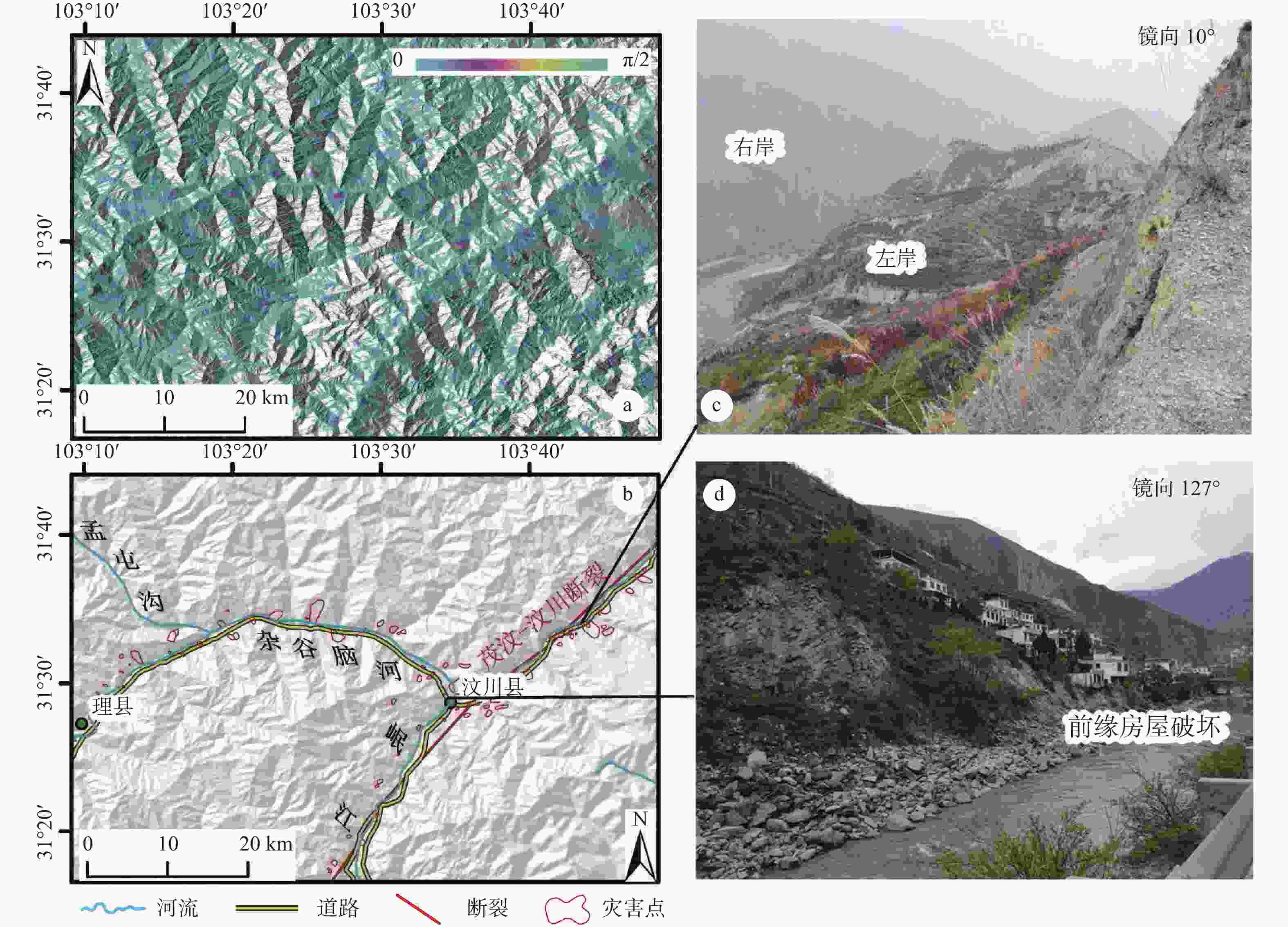
图 10 C区滑坡分布及野外典型照片
a—InSAR变形图;b—解译结果图;c、d—野外典型照片
Figure 10. Distribution map of landslides and typical field photos of Zone C
(a) InSAR-observed deformation map; (b) Distribution map of landslides; (c and d) Typical field photos

图 11 D区滑坡分布及野外典型照片
a—InSAR变形图;b—解译结果图;c、d—野外典型照片
Figure 11. Distribution map of landslides and typical field photos of Zone D
(a) InSAR-observed deformation map; (b) Distribution map of landslides; (c and d) Typical field photos
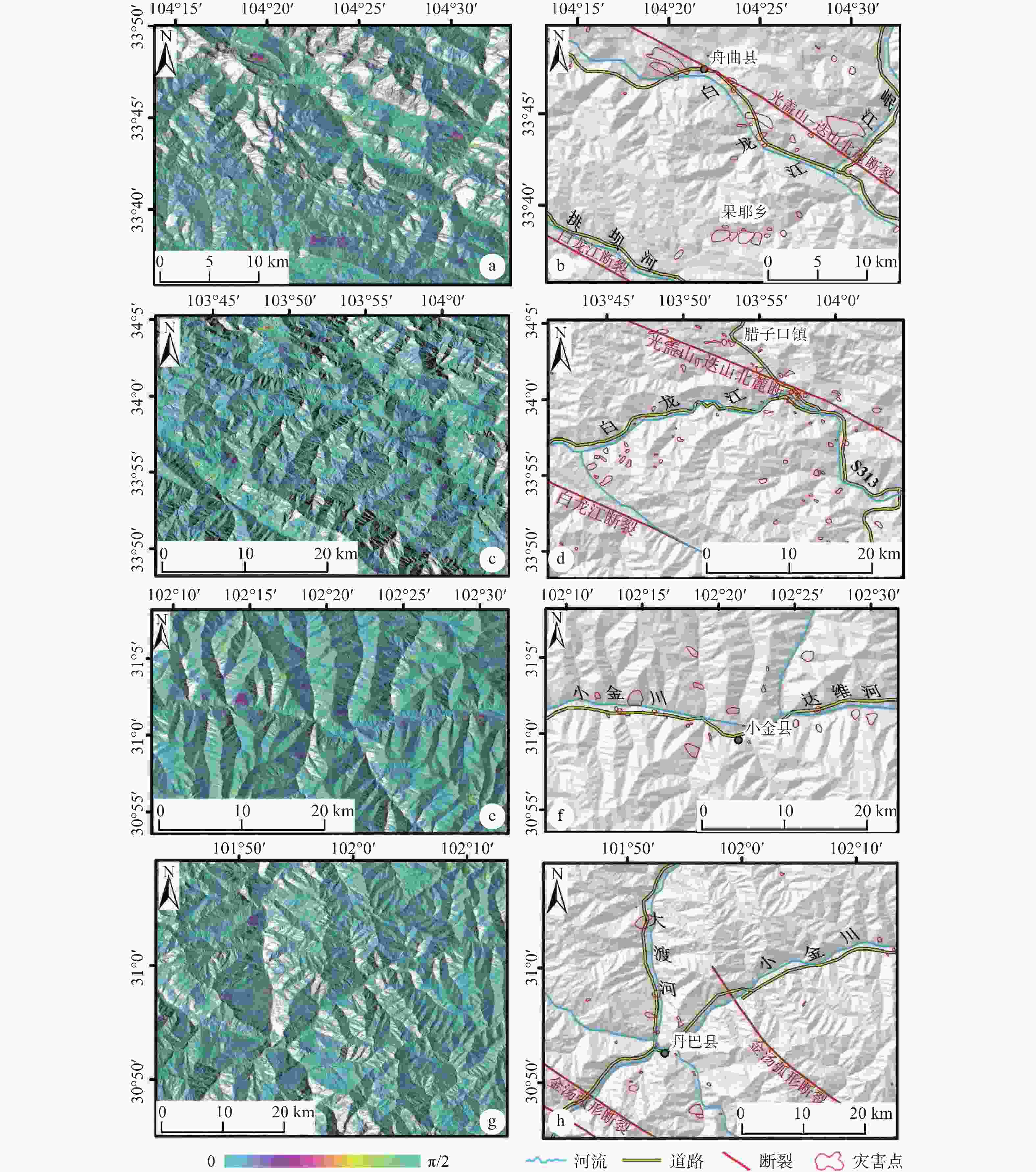
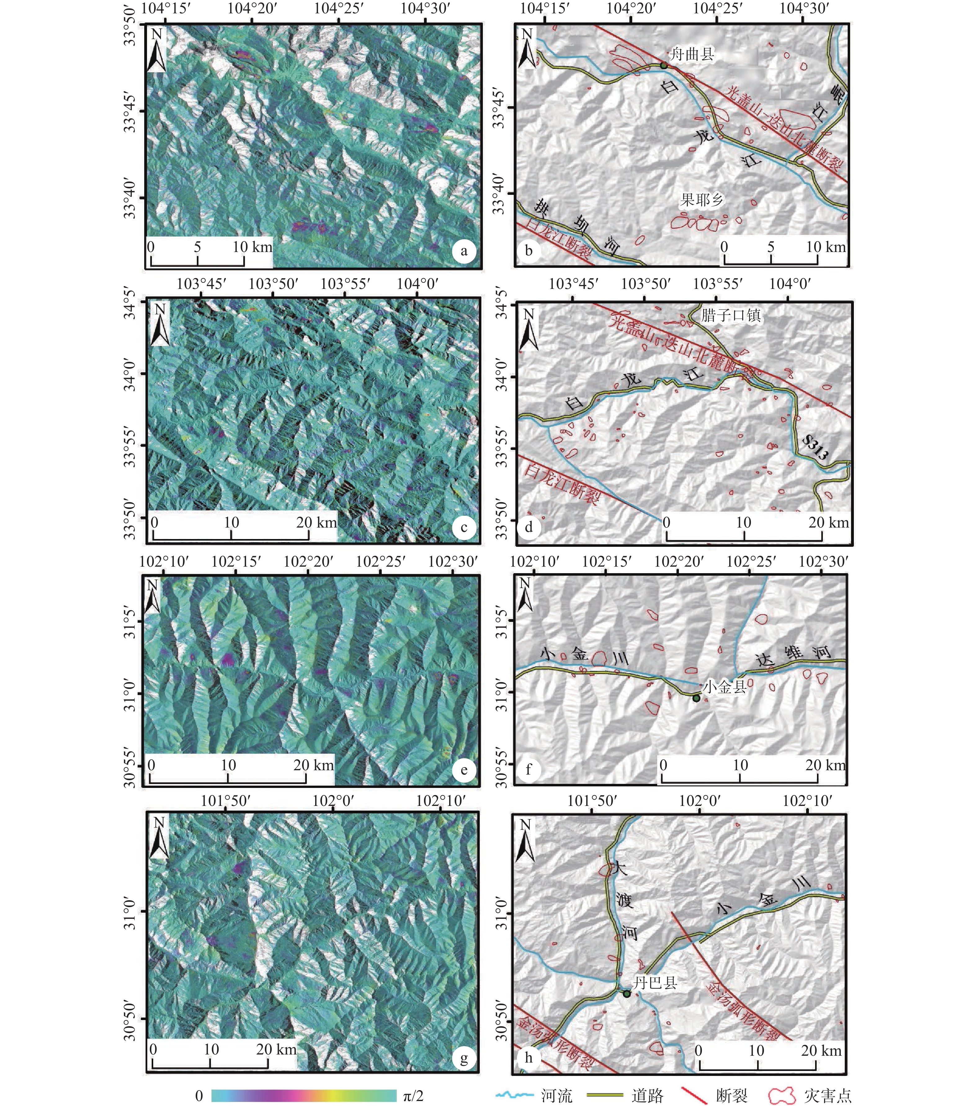
图 12 E—H区InSAR变形图及解译滑坡分布图
a—E区InSAR变形图;b—E区解译结果图;c—F区InSAR变形图;d—F区解译结果图;e—G区InSAR变形图;f—G区解译结果图;g—H区InSAR变形图;h—H区解译结果图
Figure 12. InSAR-observed deformation map and distribution map of landslides in Zones E−H
(a) InSAR-observed deformation map of Zone E; (b) Distribution map of landslides in Zone E; (c) InSAR-observed deformation map of Zone F; (d) Distribution map of landslides in Zone F; (e) InSAR-observed deformation map of Zone G; (f) Distribution map of landslides in Zone G; (g) InSAR-observed deformation map of Zone H; (h) Distribution map of landslides in Zone H
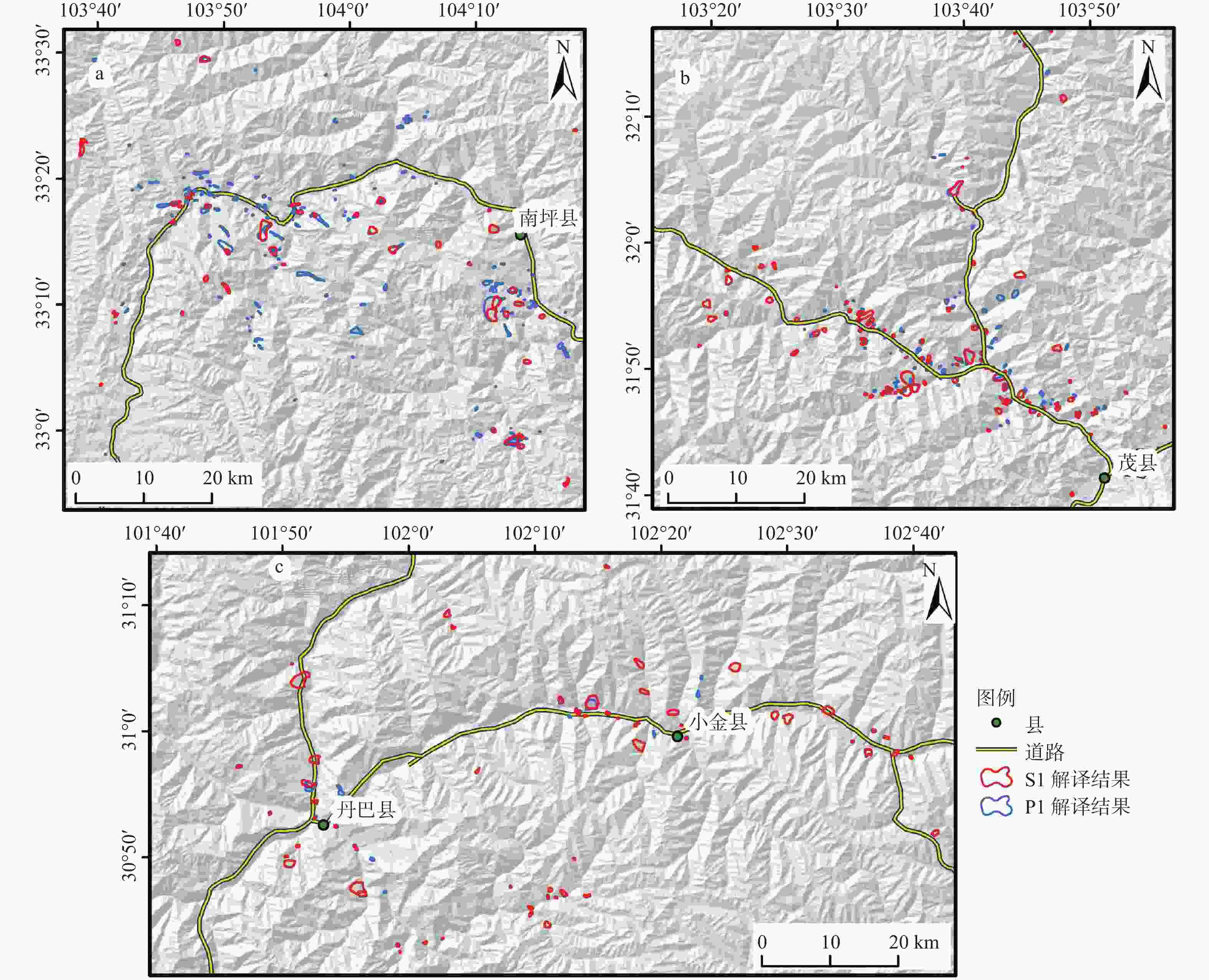
图 13 ALOS-2解译结果与Sentinel-1A解译结果对比图
a—九寨沟地区;b—茂县地区;c—丹巴−小金县地区
Figure 13. Comparison of landslides interpreted by ALOS-2 and Sentinel-1A
(a) Jiuzhaigou; (b) Maoxian; (c) Danba–Xiaojin
表 1 研究区SAR数据基本参数
Table 1. Basic parameters of the SAR data
数据卫星 数据类型 数据区域 获取日期 入射角/(°) 轨道状态 SLC数据
分辨率/(m×m)ALOS-2 Extra-fine 丹巴−小金县 20171117、20171229、20180209、
20180323、2018050436.1791 升轨 1.43×2.13 ALOS-2 Extra-fine 茂县 20171126、20171224、20180204、
20180415、20180513、20180610、
2018070836.1763 升轨 1.43×2.12 ALOS-2 Extra-fine 茂县 20171207、20180104、20180201、
20180301、20190329、2018042632.4006 降轨 1.43×1.82 ALOS-2 Extra-fine 九寨沟 20180113、20180310、20180407、
20180922、20181103、20181201、
20190112、20190309、20190323、
20190601、20190713、20190810、
20190921、20200111、20200208、
2020041839.6627 降轨 1.43×1.84 ALOS-2 Extra-fine 九寨沟 20171210、20180121、20180304、
20180429、20180624、20180819、
20180916、20181028、20181223、
20190120、20190203、20190414、
20190512、20190707、20190901、
20191013、20191208、20191222、
20200119、20200216、20200301、
20200329、2020041242.8997 升轨 1.43×2.21 Sentinel-1A TOP 轨道55,窗口97、102、107
轨道26, 窗口88、93、98
轨道128, 窗口89、94、99、104201901—202003 39.56 升轨 13.98×2.33 Sentinel-1A TOP 轨道62, 窗口479、484、489、494
轨道135, 窗口483、488、493
轨道164, 窗口485、490201901—202003 39.55 降轨 13.98×2.33  下载: 导出CSV
-
CAO P J, CHENG S Y, LIN H X, et al. , 2021. DEM in quantitative analysis of structural geomorphology: application and prospect[J]. Journal of Geomechanics, 27(6): 949-962. (in Chinese with English abstract) CUI P, WEI F Q, HE S M, et al. , 2008. Mountain disasters induced by the earthquake of May 12 in Wenchuan and the disasters mitigation[J]. Mountain Research, 26(3): 280-282. (in Chinese with English abstract) DAI F C, XU C, YAO X, et al. , 2011. Spatial distribution of landslides triggered by the 2008 MS 8.0 Wenchuan earthquake, China[J]. Journal of Asian Earth Sciences, 40(4): 883-895. doi: 10.1016/j.jseaes.2010.04.010 DAI F C, DENG J H, 2020. Development characteristics of landslide hazards in three-rivers basin of Southeast Tibetan Plateau[J]. Advanced Engineering Sciences, 52(5): 3-15. (in Chinese with English abstract) DUN J W, FENG W K, YI X Y, et al. , 2021. Detection and mapping of active landslides before impoundment in the Baihetan reservoir Area (China) based on the time-series InSAR method[J]. Remote Sensing, 13(16): 3213. doi: 10.3390/rs13163213 GE D Q, DAI K R, GUO Z C, et al. , 2019. Early identification of serious geological hazards with integrated remote sensing technologies: thoughts and recommendations[J]. Geomatics and Information Science of Wuhan University, 44(7): 949-956. GUO C B, DU Y B, ZHANG Y S, et al. , 2015. Geohazard effects of the Xianshuihe fault and characteristics of typical landslides in western Sichuan[J]. Geological Bulletin of China, 34(1): 121-134. (in Chinese with English abstract) GUO J P, 2019. Study on the influence of river erosion on landslide stability[J]. Gansu Water Resources and Hydropower Technology, 55(11): 38-41, 45. (in Chinese) GUO X, 2009. Characteristics and mechanism analysis of the great Wenchuan earthquake[J]. Journal of Earthquake Engineering and Engineering Vibration, 29(6): 74-87. (in Chinese with English abstract) LI C D, LONG J J, JIANG X H, et al. , 2020. Advance and prospect of formation mechanism for reservoir landslides[J]. Bulletin of Geological Science and Technology, 39(1): 67-77. (in Chinese with English abstract) LI S Z, DAI S, WANG H W, et al. , 2015. Fault features and their implications on distribution and formation of landslides in Bailongjiang Region[J]. Journal of Lanzhou University (Natural Sciences), 51(2): 145-152. (in Chinese with English abstract) LI Y X, ZHANG Y, SU X J, et al. , 2021. Early identification and characteristics of potential landslides in the Bailong River Basin using InSAR technique[J]. National Remote Sensing Bulletin, 25(2): 677-690. (in Chinese with English abstract) LIU X H, YAO X, ZHOU Z K, et al. , 2018. Study of the technique for landslide rapid recognition by InSAR[J]. Journal of Geomechanics, 24(2): 229-237. (in Chinese with English abstract) LUO X H, LI J Y, 2003. Analysis of reservoir impoundment influence on reservoir bank slide[J]. Design of Hydroelectric Power Station, 19(3): 61-64, 69. (in Chinese with English abstract) LV J, WANG X S, SU J R, et al. , 2013. Hypocentral location and source mechanism of the MS7.0 Lushan earthquake sequence[J]. Chinese Journal of Geophysics, 56(5): 1753-1763. (in Chinese with English abstract) PENG J B, MA R Y, LU Q Z, et al. , 2004. Geological hazards effects of uplift of Qinghai-Tibet Plateau[J]. Advance in Earth Sciences, 19(3): 457-466. (in Chinese with English abstract) QI S W, XU Q, LIU C L, et al. , 2009. Slope instabilities in the severest disaster areas of 5·12 Wenchuan earthquake[J]. Journal of Engineering Geology, 17(1): 39-49. (in Chinese with English abstract) QIAO Y X, MA Z S, LV F J, 2009. Characteristics and dynamic cause mechanism of the Wenchuan Earthquake geological hazards[J]. Geology in China, 36(3): 736-741. (in Chinese with English abstract) QIN H B, 2011. The mechanism of landslide influenced by rainfall and reservoir water level fluctuation and renewed criterion research in Three-Gorges reservoir[D]. Yichang: China Three Gorges University. (in Chinese with English abstract) QIN Y L, WU J L, ZHAN H J, et al. , 2021. Discussion on the correlation between active fault and geological disaster distribution in the Ganzi area, western Sichuan province, China[J]. Journal of Geomechanics, 27(3): 463-474. (in Chinese with English abstract) TANG H M, 2008. Gong Cheng Di Zhi Xue Ji Chu[M]. Beijing: Chemical Industry Press: 92-96. (in Chinese) WANG Z D, WEN X H, TANG W, et al. , 2020. Early detection of geological hazards in Longmenshan-Dadu river Area using various InSAR techniques[J]. Geomatics and Information Science of Wuhan University, 45(3): 451-459. (in Chinese with English abstract) XU C, XIAO J Z, 2013. Spatial analysis of landslides triggered by the 2013 MS7.0 Lushan earthquake: a case study of a typical rectangle area in the northeast of Taiping town[J]. Seismology and Geology, 35(2): 436-451. (in Chinese with English abstract) XU C, XU X W, 2014. The spatial distribution pattern of landslides triggered by the 20 April 2013 Lushan earthquake of China and its implication to identification of the seismogenic fault[J]. Chinese Science Bulletin, 59(13): 1416-1424. (本条文献在正文中未被引用) doi: 10.1007/s11434-014-0202-0 XU C, XU X W, YAO X, et al. , 2014. Three (nearly) complete inventories of landslides triggered by the May 12, 2008 Wenchuan MW7.9 earthquake of China and their spatial distribution statistical analysis[J]. Landslides, 11(3): 441-461. doi: 10.1007/s10346-013-0404-6 XU L, LI J H, LIU C H, et al. , 2017. Research on geomorphological morphology and regionalization of Hoh Xil Based on digital elevation model (DEM)[J]. Acta Scientiarum Naturalium Universitatis Pekinensis, 53(5): 833-842. (in Chinese with English abstract) XU Q, DONG X J, LI W L, 2019. Integrated space-air-ground early detection, monitoring and warning system for potential catastrophic geohazards[J]. Geomatics and Information Science of Wuhan University, 44(7): 957-966. (in Chinese with English abstract) XU X W, WEN X Z, YE J Q, et al. , 2008. The MS8.0 Wenchuan earthquake surface ruptures and its seismogenic structure[J]. Seismology and Geology, 30(3): 597-629. (in Chinese with English abstract) YANG G H, HAN Y P, WANG M, et al. , 2003. Horizontal deformation in several major seismically active areas in Chinese mainland[J]. Journal of Geodesy and Geodynamics, 23(3): 42-49. (in Chinese with English abstract) YANG Z, 2017. Study on fault activity in Western Sichuan based on InSAR data[D]. Xi’an: Changan University. (in Chinese with English abstract) YAO C C, YAO X, GU Z K, et al. , 2022. Analysis on the development law of active geological hazards in the Loess Plateau based on InSAR identification[J]. Journal of Geomechanics, 28(2): 257-267. (in Chinese with English abstract) YAO J M, YAO X, LIU X H, et al. , 2022. Identification and analysis of active landslide disaster in Tianshui city using InSAR technology[J]. Science of Surveying and Mapping, 47(1): 121-132. (in Chinese with English abstract) YAO X, ZHOU Z K, LI L J, et al. , 2017. InSAR co-seismic deformation of 2017 MS7.0 Jiuzhaigou earthquake and discussions on seismogenic tectonics[J]. Journal of Geomechanics, 23(4): 507-514. (in Chinese with English abstract) YAO X, DENG J H, LIU X H, et al. , 2020. Primary recognition of active landslides and development rule analysis for Pan Three-river-parallel territory of Tibet Plateau[J]. Advanced Engineering Sciences, 52(5): 16-37. (in Chinese with English abstract) YIN Y P, 2009. Features of landslides triggered by the Wenchuan earthquake[J]. Journal of Engineering Geology, 17(1): 29-38. (in Chinese with English abstract) ZHANG Y S, GUO C B, YAO X, et al. , 2016. Research on the geohazard effect of active fault on the eastern margin of the Tibetan Plateau[J]. Acta Geoscientica Sinica, 37(3): 277-286. (in Chinese with English abstract) ZHAO B Q, 2019. Surface deformation characteristics and early identification of potential landslides based on In SAR technology in Bailong river basin[D]. Lanzhou: Lanzhou University. (in Chinese with English abstract) 曹鹏举, 程三友, 林海星, 等, 2021. DEM在构造地貌定量分析中的应用与展望[J]. 地质力学学报, 27(6): 949-962. doi: 10.12090/j.issn.1006-6616.2021.27.06.077 崔鹏, 韦方强, 何思明, 等, 2008. 5·12汶川地震诱发的山地灾害及减灾措施[J]. 山地学报, 26(3): 280-282. doi: 10.3969/j.issn.1008-2786.2008.03.006 戴福初, 邓建辉, 2020. 青藏高原东南三江流域滑坡灾害发育特征[J]. 工程科学与技术, 52(5): 3-15. 葛大庆, 戴可人, 郭兆成, 等, 2019. 重大地质灾害隐患早期识别中综合遥感应用的思考与建议[J]. 武汉大学学报·信息科学版, 44(7): 949-956. 郭长宝, 杜宇本, 张永双, 等, 2015. 川西鲜水河断裂带地质灾害发育特征与典型滑坡形成机理[J]. 地质通报, 34(1): 121-134. doi: 10.3969/j.issn.1671-2552.2015.01.010 郭京平, 2019. 河流侵蚀对滑坡稳定性影响研究[J]. 甘肃水利水电技术, 55(11): 38-41, 45. 郭迅, 2009. 汶川大地震震害特点与成因分析[J]. 地震工程与工程振动, 29(6): 74-87. 李长冬, 龙晶晶, 姜茜慧, 等, 2020. 水库滑坡成因机制研究进展与展望[J]. 地质科技通报, 39(1): 67-77. 李淑贞, 戴霜, 王华伟, 等, 2015. 白龙江地区断裂构造与滑坡分布及发生关系[J]. 兰州大学学报(自然科学版), 51(2): 145-152. 李媛茜, 张毅, 苏晓军, 等, 2021. 白龙江流域潜在滑坡InSAR识别与发育特征研究[J]. 遥感学报, 25(2): 677-690. doi: 10.11834/jrs.20210094 刘星洪, 姚鑫, 周振凯, 等, 2018. 滑坡灾害InSAR应急排查技术方法研究[J]. 地质力学学报, 24(2): 229-237. doi: 10.12090/j.issn.1006-6616.2018.24.02.024 罗晓红, 李进元, 2003. 水库蓄水对库岸滑坡影响分析[J]. 水电站设计, 19(3): 61-64, 69. doi: 10.3969/j.issn.1003-9805.2003.03.017 吕坚, 王晓山, 苏金蓉, 等, 2013. 芦山7.0级地震序列的震源位置与震源机制解特征[J]. 地球物理学报, 56(5): 1753-1763. doi: 10.6038/cjg20130533 彭建兵, 马润勇, 卢全中, 等, 2004. 青藏高原隆升的地质灾害效应[J]. 地球科学进展, 19(3): 457-466. doi: 10.3321/j.issn:1001-8166.2004.03.018 祁生文, 许强, 刘春玲, 等, 2009. 汶川地震极重灾区地质背景及次生斜坡灾害空间发育规律[J]. 工程地质学报, 17(1): 39-49. doi: 10.3969/j.issn.1004-9665.2009.01.005 乔彦肖, 马中社, 吕凤军, 2009. 汶川地震地质灾害发育特点及动因机制分析[J]. 中国地质, 36(3): 736-741. doi: 10.3969/j.issn.1000-3657.2009.03.020 秦洪斌, 2011. 三峡库区库水与降雨诱发滑坡机理及复活判据研究[D]. 宜昌: 三峡大学. 秦宇龙, 吴建亮, 詹涵钰, 等, 2021. 川西甘孜地区活动断裂与地质灾害分布相关性探讨[J]. 地质力学学报, 27(3): 463-474. doi: 10.12090/j.issn.1006-6616.2021.27.03.042 唐辉明, 2008. 工程地质学基础[M]. 北京: 化学工业出版: 92-96. 王之栋, 文学虎, 唐伟, 等, 2020. 联合多种InSAR技术的龙门山-大渡河区域地灾隐患早期探测[J]. 武汉大学学报·信息科学版, 45(3): 451-459. 许冲, 肖建章, 2013. 2013年芦山地震滑坡空间分布分析: 以太平镇东北方向的一个典型矩形区为例[J]. 地震地质, 35(2): 436-451. 许丽, 李江海, 刘持恒, 等, 2017. 基于数字高程模型(DEM)的可可西里地貌及区划研究[J]. 北京大学学报(自然科学版), 53(5): 833-842. 许强, 董秀军, 李为乐, 2019. 基于天-空-地一体化的重大地质灾害隐患早期识别与监测预警[J]. 武汉大学学报·信息科学版, 44(7): 957-966. doi: 10.13203/j.whugis20190088 徐锡伟, 闻学泽, 叶建青, 等, 2008. 汶川MS8.0地震地表破裂带及其发震构造[J]. 地震地质, 30(3): 597-629. doi: 10.3969/j.issn.0253-4967.2008.03.003 杨国华, 韩月萍, 王敏, 等, 2003. 中国大陆几个主要地震活动区的水平形变[J]. 大地测量与地球动力学, 23(3): 42-49. doi: 10.3969/j.issn.1671-5942.2003.03.009 杨珍, 2017. 基于InSAR数据的川西地区断层活动研究[D]. 西安: 长安大学. 姚闯闯, 姚鑫, 顾畛逵, 等, 2022. 基于InSAR识别的黄土高原活动性地质灾害发育规律分析[J]. 地质力学学报, 28(2): 257-267. 姚佳明, 姚鑫, 刘星洪, 等, 2022. InSAR技术的天水市活动性滑坡灾害识别与分析[J]. 测绘科学, 47(1): 121-132. 姚鑫, 周振凯, 李凌婧, 等, 2017. 2017年四川九寨沟MS7.0地震InSAR同震形变场及发震构造探讨[J]. 地质力学学报, 23(4): 507-514. doi: 10.3969/j.issn.1006-6616.2017.04.001 姚鑫, 邓建辉, 刘星洪, 等, 2020. 青藏高原泛三江并流区活动性滑坡InSAR初步识别与发育规律分析[J]. 工程科学与技术, 52(5): 16-37. 殷跃平, 2009. 汶川八级地震滑坡特征分析[J]. 工程地质学报, 17(1): 29-38. doi: 10.3969/j.issn.1004-9665.2009.01.004 张永双, 郭长宝, 姚鑫, 等, 2016. 青藏高原东缘活动断裂地质灾害效应研究[J]. 地球学报, 37(3): 277-286. doi: 10.3975/cagsb.2016.03.03 -

 下载:
下载:


计量
- 文章访问数: 1676
- HTML全文浏览量: 598
- PDF下载量: 197
- 被引次数: 0
