

Evolution and changes of the ancient Luanhe fluvial fan since the Quaternary in Tangshan, Hebei Province
-
摘要: 古滦河冲积扇研究的关注点更多在全新世,对其更新世的演化与变迁一直没有进行过系统研究。根据古滦河冲积扇上PZK10、PZK20钻孔的磁性地层学、年代地层学、沉积学、测井沉积学、岩芯色度分析等,对古滦河冲积平原的第四纪三维地质结构、冲积扇体的规模以及迁移规律进行综合研究,结果表明: PZK10孔揭露了上新世时沉积的巨厚洪积成因“泥包砾”地层,早更新世时发育两个冲积扇−湖相旋回,中更新世时发育辫状河沉积,晚更新世发育湖相、冲积扇相、辫状河相沉积。PZK20孔上新世沉积了一套巨厚“泥包砾”层,早更新世为扇前平原−辫状河相沉积,中更新世为辫状河−冲积扇相沉积,晚更新世为辫状河沉积。古滦河发育两期冲积扇,第一期为早更新世早期,在沙流河镇一带出山口形成的规模较大的冲积扇;第二期为早更新世中期,古滦河在现今丘庄水库一带发生分流,在丰润区一带出山口形成的冲积扇。中更新世,第一期冲积扇开始萎缩,第二期冲积扇继续发育,形成巨厚砾石层;晚更新世,古滦河在迁西县城以北发生袭夺,东流迁移出研究区,在西峡口进入迁安盆地,形成以西峡口为顶点的冲积扇。Abstract: The study of the ancient Luanhe alluvial fan has focused more on the Holocene, and no systematic study has been conducted on its Pleistocene evolution and variation. We studied the magnetic stratigraphy, chronostratigraphy, sedimentology, logging sedimentology, and core color of the boreholes PZK10 and PZK20 in the ancient Luanshe alluvial fan. Based on that, we carried out a comprehensive study of the Quaternary three-dimensional geological structure, the scale of the alluvial fan body, and the migration pattern of the ancient Luanshe alluvial plain. The borehole PZK10 recorded Brunches, Matuyama, and Gauss polarity chrons; the boundaries between them are 77.42 m and 71.50 m, respectively. The borehole PZK10 also revealed a set of diluvial “mud-gravel” layers deposited in the Pliocene, with two alluvial fan-lake phase cycles in the Early Pleistocene, braided river deposits in the Middle Pleistocene, and lake, alluvial fan and braided river facies in the late Pleistocene. A set of highly thick “mud-gravel” layers was deposited in the Pliocene of the borehole PZK20. The early Pleistocene is the fan-front–plain-braided river facies deposition, the middle Pleistocene is the braided river–alluvial fan facies deposition, and the late Pleistocene is the braided river deposition. Early Pleistocene, the ancient Luanhe River out of the mountain formed a large-scale alluvial fan in Shaliuhe town, which is the first stage of the ancient Luanhe alluvial fan. In the middle of the early Pleistocene, the ancient Luanhe River diverged in the current Qiuzhuang reservoir, and the alluvial fan formed in the Fengrun area, namely the second stage alluvial fan. In the middle Pleistocene, the first alluvial fan began to shrink, while the second alluvial fan continued to develop, forming a vast thick gravel layer. Late Pleistocene, the ancient Luanhe river was captured north of Qianxi county. It flowed eastwards and migrated out of the research area into the Qian’an basin in Xixiakou village, forming the alluvial fan with Xixiakou village as its apex.
-
Key words:
- Quaternary /
- ancient Luanhe alluvial fan /
- borehole /
- paleomagnetic /
- optically stimulated luminescence /
- logging curve
-
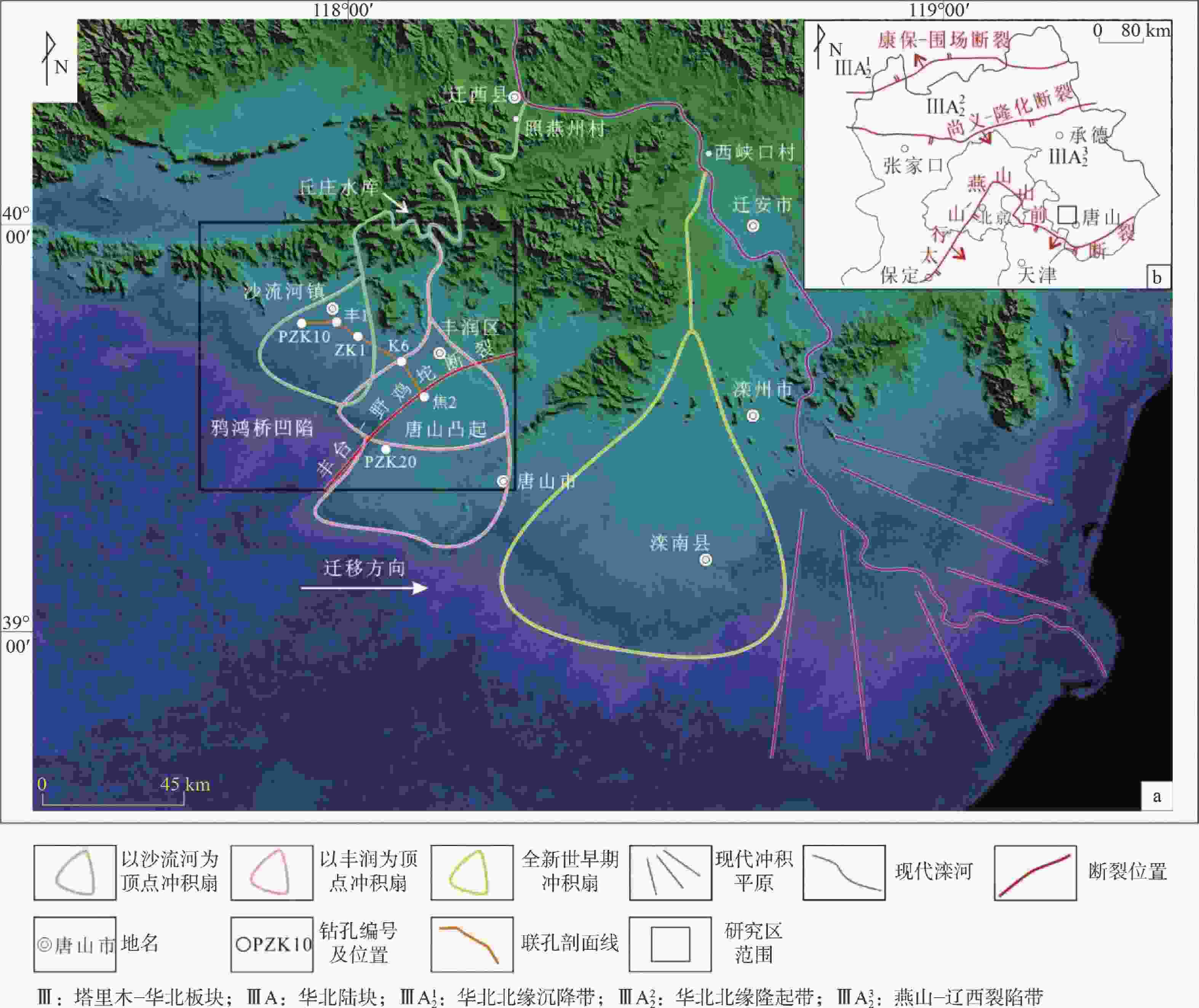
图 1 研究区大地构造位置及古滦河冲积扇地貌遥感影像图
a—研究区位置及古滦河冲积扇地貌遥感影像图;b—大地构造位置
Figure 1. Geotectonic location of the study area and remote sensing image of the ancient Luanhe fluvial fan landform
(a) Location of the study area and remote sensing image of the ancient Luanhe River fluvial fan landform; (b) Geotectonic position
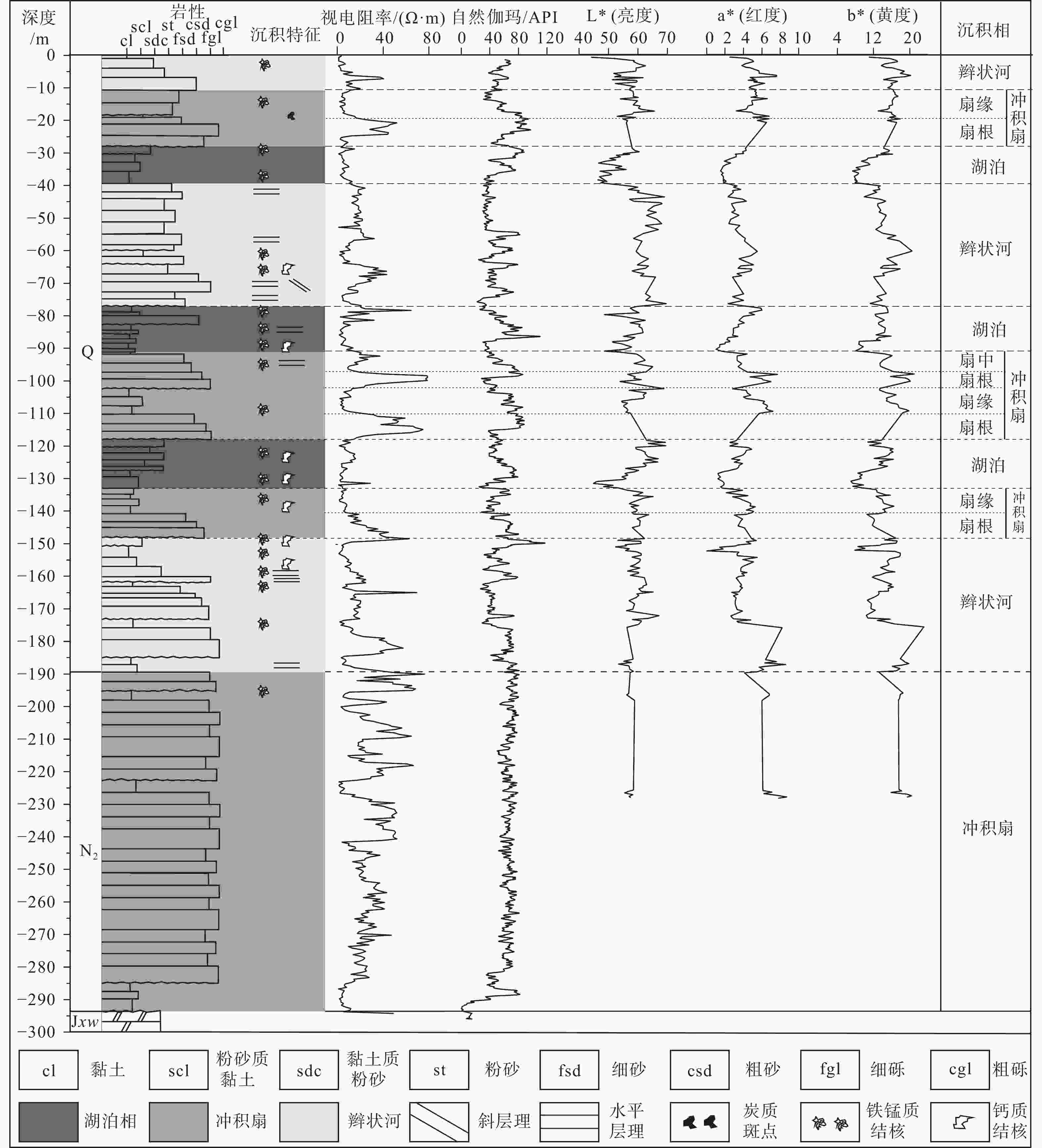
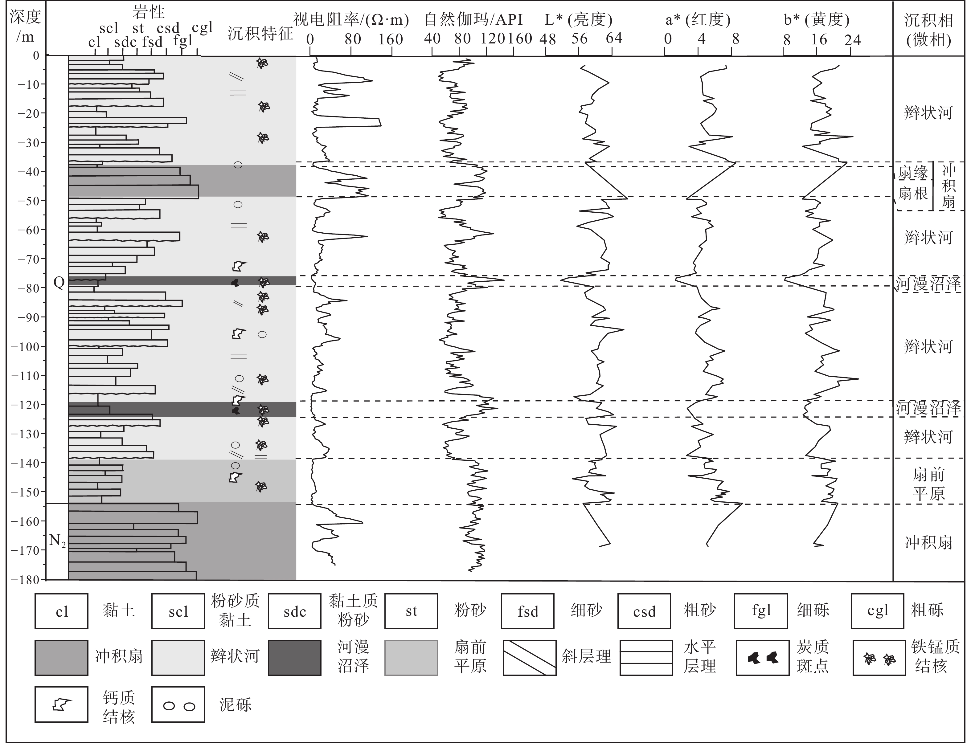
图 3 PZK10孔色度曲线、测井曲线、沉积相分类图
Figure 3. Color index curves, logging curves and sedimentary types of the borehole PZK10
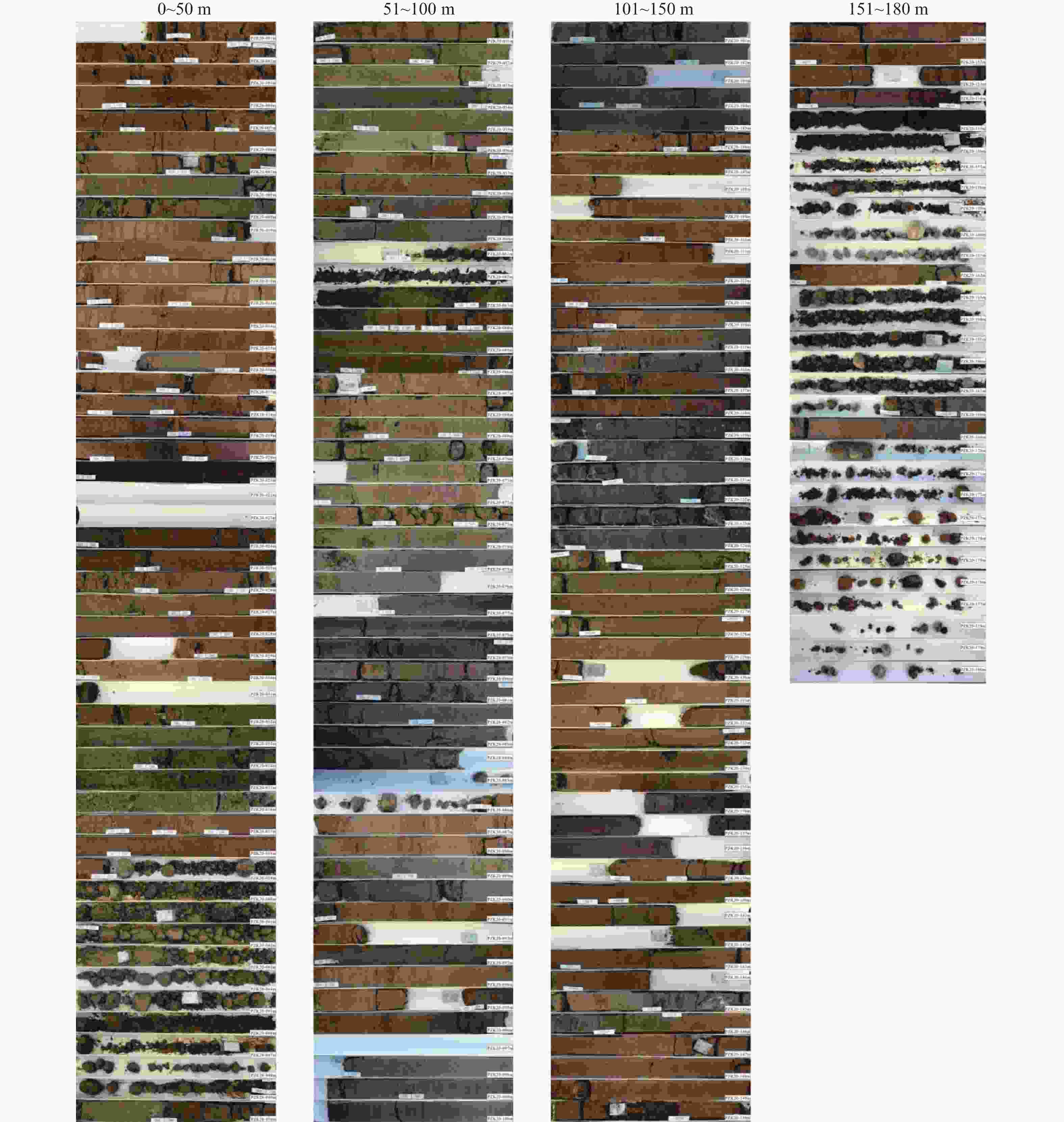
图 4 PZK20孔照片(据陈宏强等,2021修改)
Figure 4. Photographs of the borehole PZK20(modified from Chen et al., 2021)
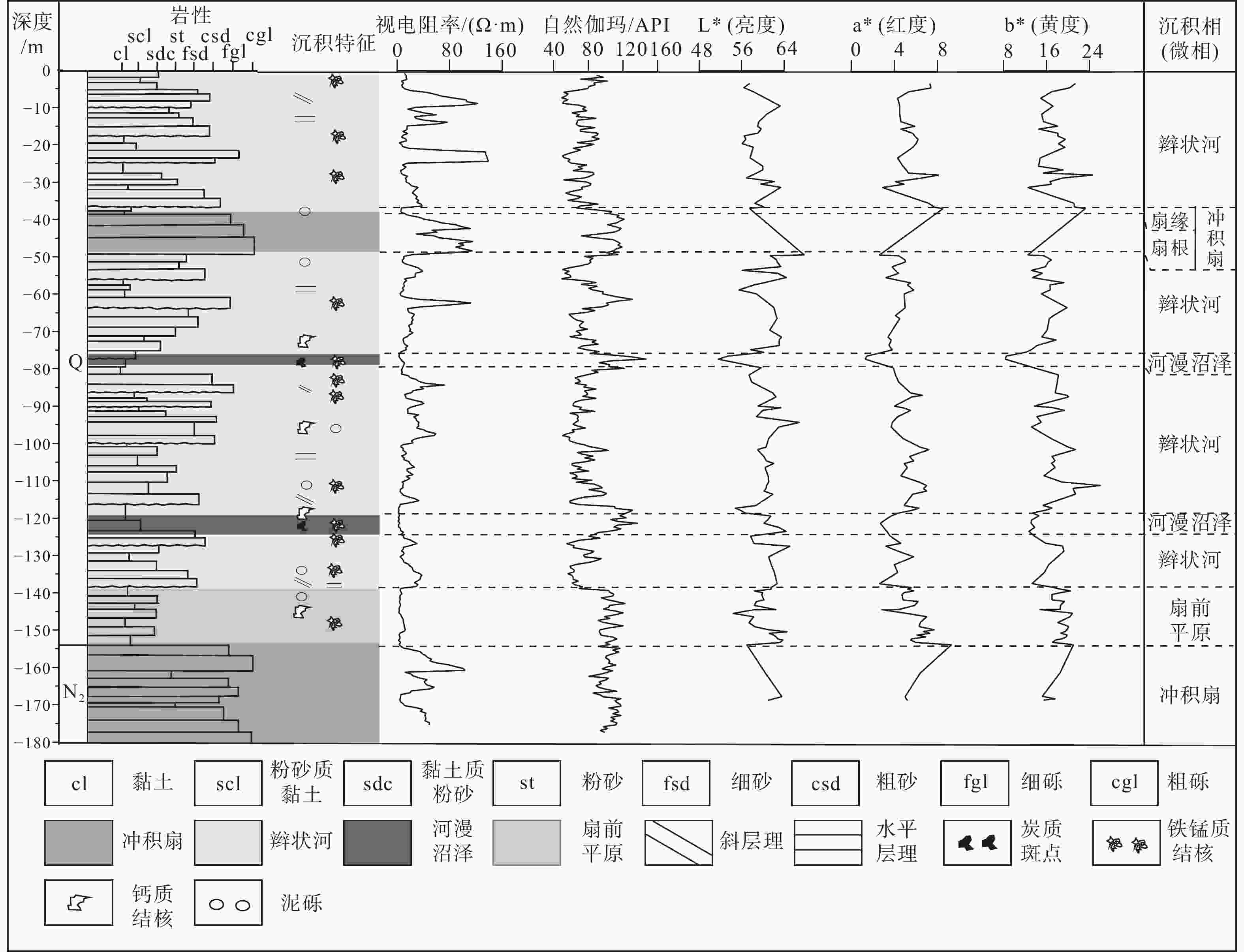
图 5 PZK20孔色度曲线、测井曲线、沉积相分类图
Figure 5. Color index curves, logging curves and sedimentary types of the borehole PZK20

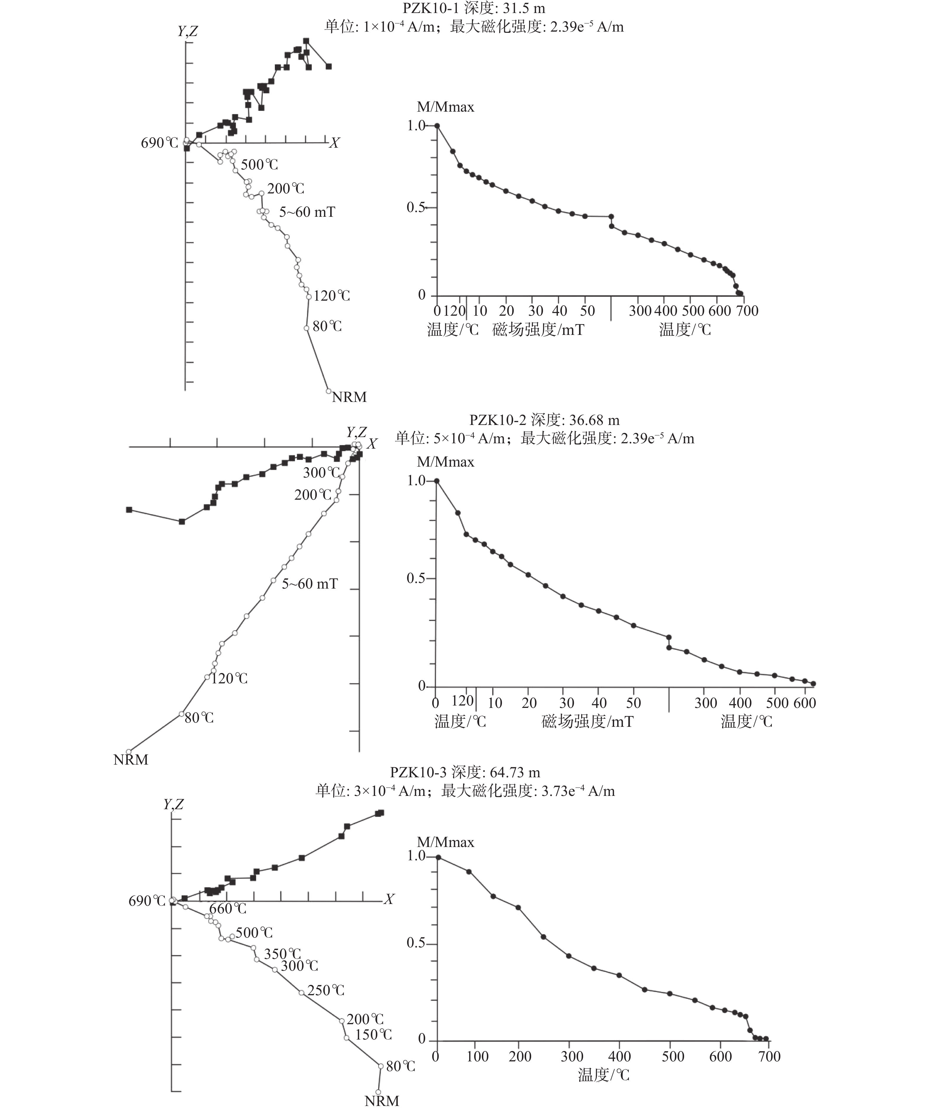
图 6 PZK10钻孔代表样品正交矢量投影图和热退磁强度衰减曲线图
M—磁化强度;NRM—天然剩磁强度
Figure 6. Orthogonal vector plots and decay curves of the natural remanent magnetization(NRM)of representative specimens from the borehole PZK10
M–magnetization; NRM–natural remanent magnetization
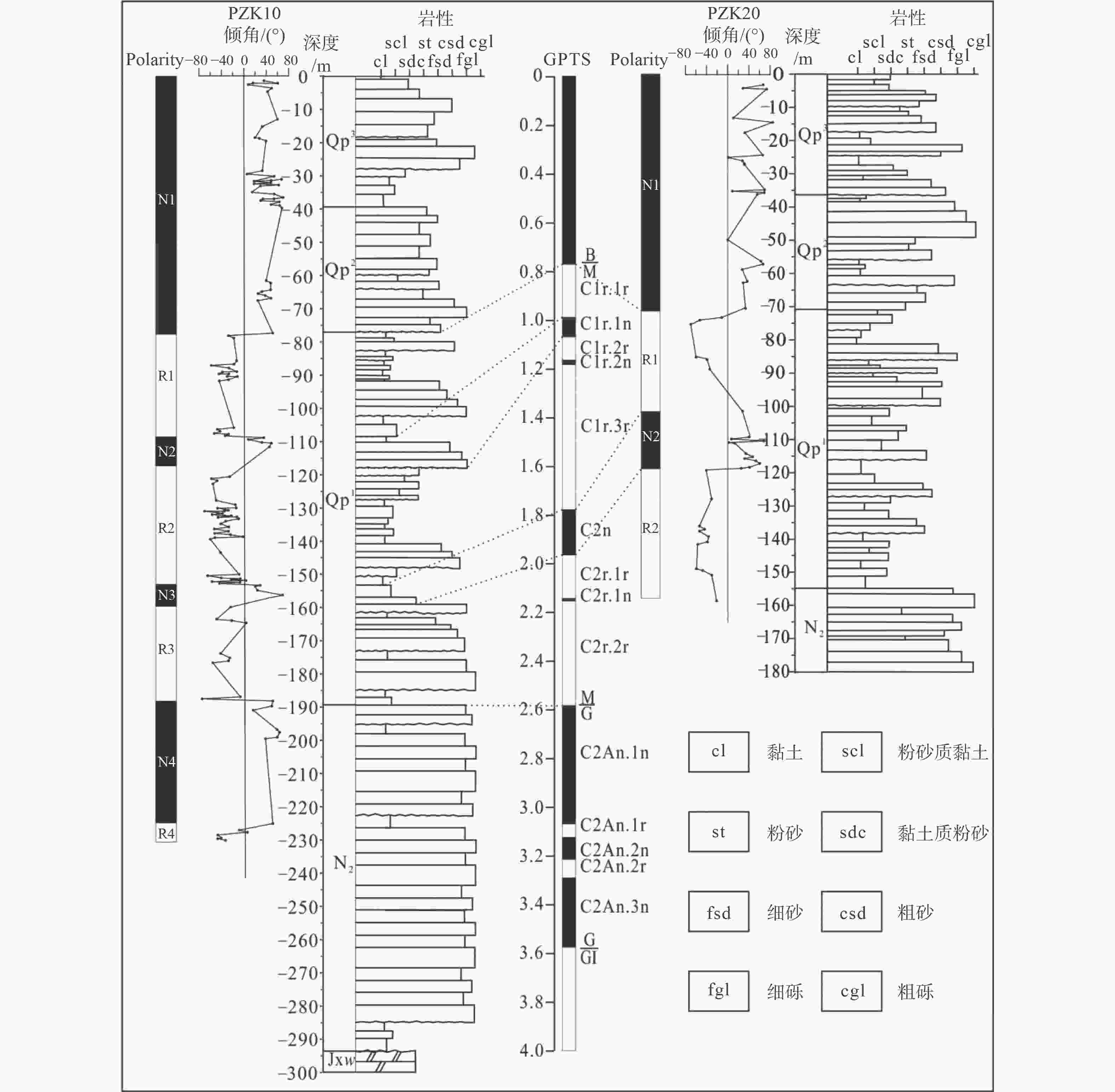
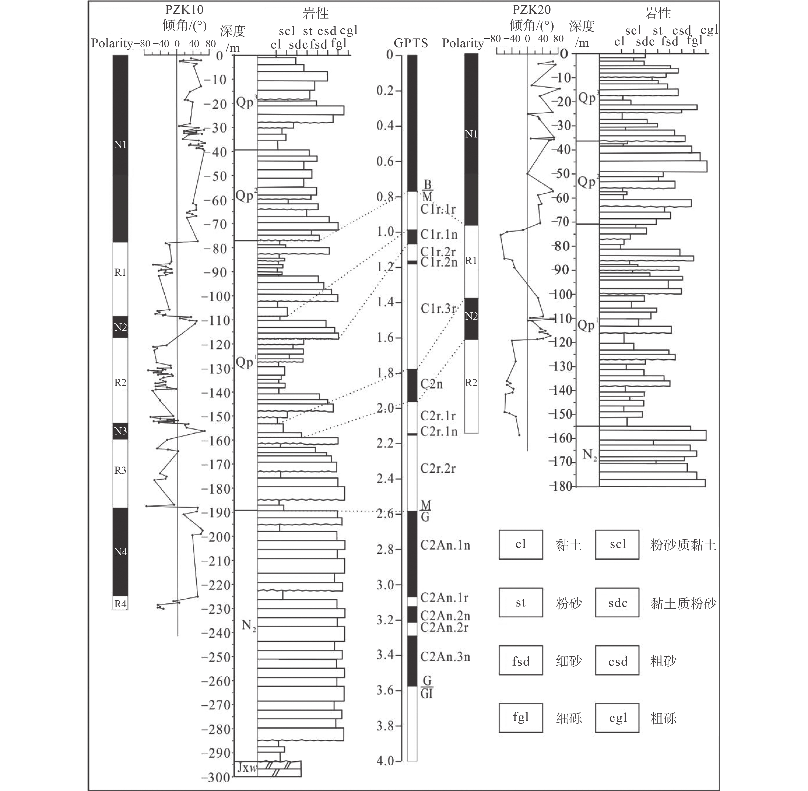
图 7 PZK10、PZK20孔岩石地层、磁性地层及其地磁极性年表(Cande and Kent,1995)对比图
Figure 7. Lithostratigraphy and magnetic stratigraphy of the boreholes PZK10 and PZK20, and their correlations with the geomagnetic polarity timescale(Cande and Kent, 1995)
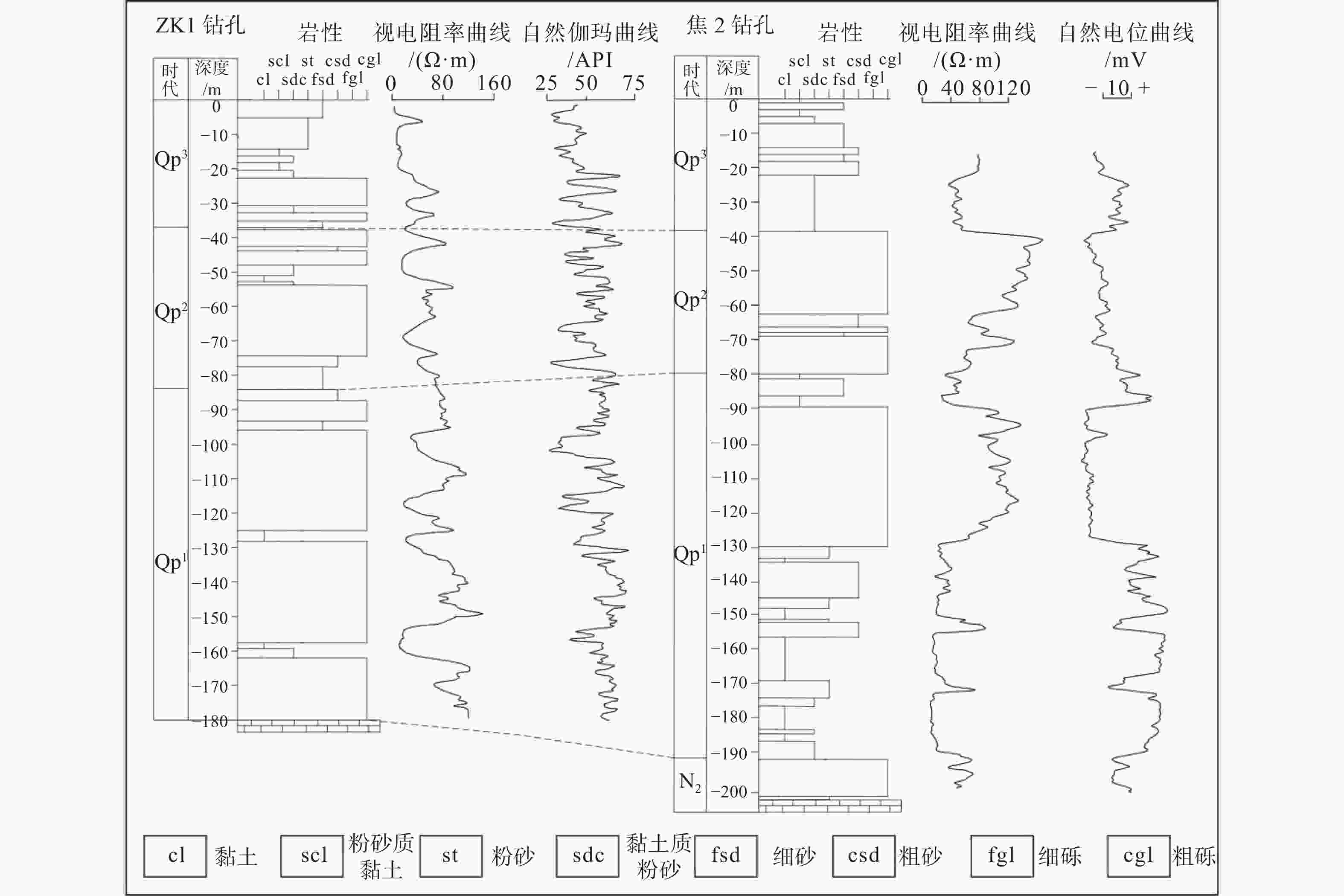
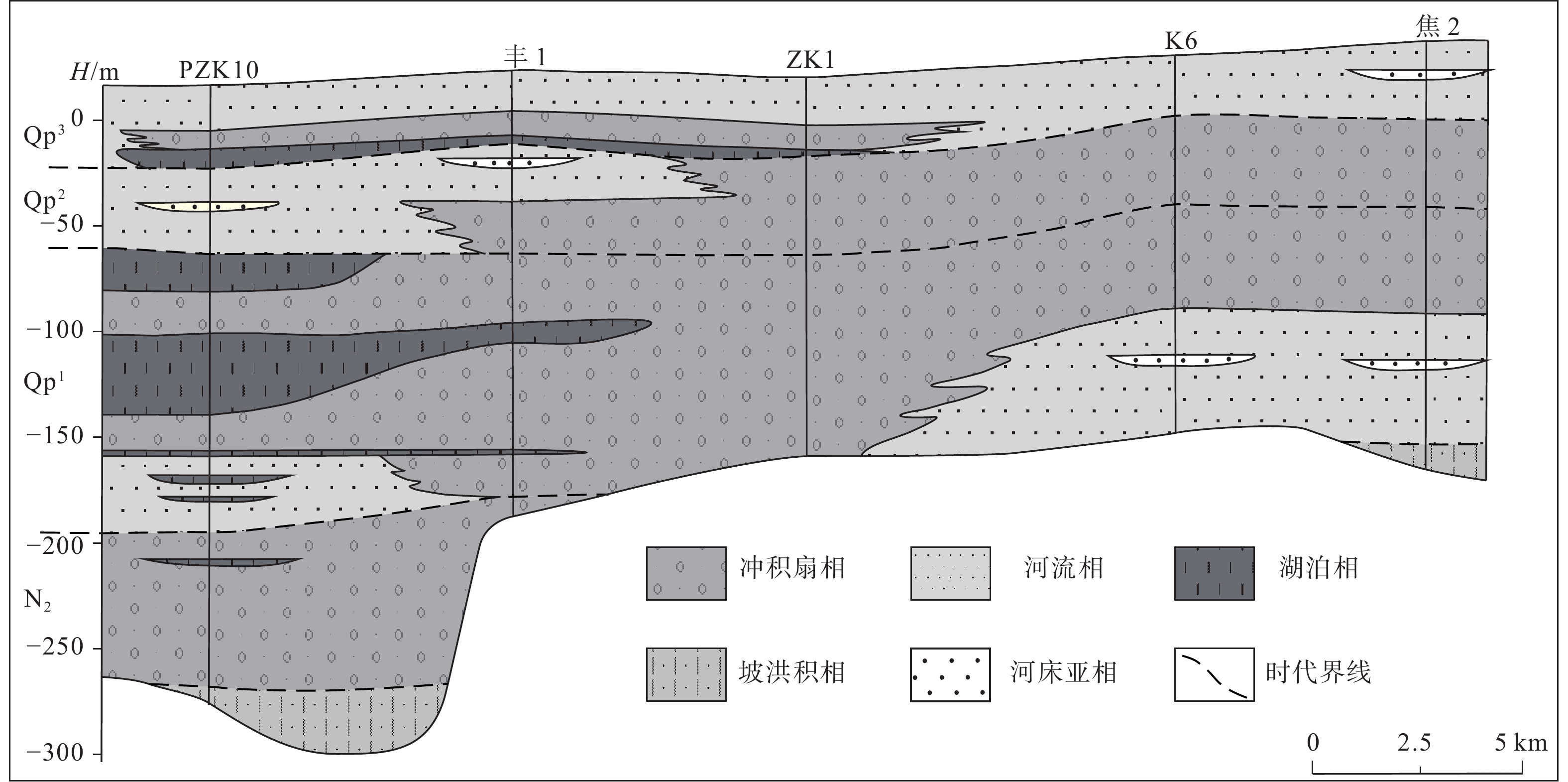
图 8 ZK1、焦2钻孔地层柱状图及测井曲线(胡云壮等,2014)
Figure 8. Stratigraphic column and logging curves of the boreholes ZK1 and Jiao-2 (Hu et al., 2014)
表 1 沉积相特征统计表
Table 1. Statistical table of sedimentary facies characteristics
沉积相(微相) 色度特征 测井曲线特征 冲积扇相 a*>2.5,b*>13 视电阻率和自然伽玛曲线一般呈高幅箱形,视电阻率数值较高,自然伽玛数值也较高 湖泊相 a*<2.5、b*<13 视电阻率曲线一般呈漏斗形,自然伽玛曲线呈钟形,视电阻率数值较低,自然伽玛数值较高 辫状河相 a*>2.5,b*>13 视电阻率曲线一般呈钟形、箱型;自然伽玛曲线一般呈高幅齿形或呈高幅指形;砂泥比较高 河漫沼泽微相 a*<2.5、b*<13 视电阻率呈低幅箱形,自然伽玛呈高幅指形、箱型,视电阻率数值较低,自然伽玛数值较高 扇前平原微相 a*>2.5,b*>13 视电阻率曲线呈微齿形,自然伽玛曲线呈高幅齿形,齿中线呈水平平行式  下载: 导出CSV
表 2 PZK10钻孔光释光样品信息及测年数据统计表
Table 2. OSL sample information and dating data in the borehole PZK10
样品编号 埋深/m 等效剂量 /Gy U/×10−6 Th/×10−6 K/% 含水量/% 年龄/ka PZK10-OSL1 12.4 330.9 0.90 4.38 2.42 8.26 98.3±9.8 PZK10-OSL2 29.8 >375.0 0.90 4.01 2.40 17.10 >115.3
下载: 导出CSV
-
CANDE S C, KENT D V, 1995. Revised calibration of the geomagnetic polarity timescale for the Late Cretaceous and Cenozoic[J]. Journal of Geophysical Research: Solid Earth, 100(B4): 6093-6095. doi: 10.1029/94JB03098 CHEN H Q, ZHUAN S P, CHEN C, et al. , 2021. Quaternary activity of the Fengtai-Yejituo fault in Tangshan, Hebei Province: evidence from 14C and magnetic stratigraphy[J]. Geology in China, 48(2): 605-617. (in Chinese with English abstract) FANG X M, XI X X, LI J J, et al. , 1997. Discovery of the late Miocene climate change and its significance in Western China[J]. Chinese Science Bulletin, 42(23): 2521-2524. (in Chinese) doi: 10.1360/csb1997-42-23-2521 GAO S M, 1981. Facies and sedimentary model of the Luan Riverdelta[J]. Acta Geographica Sinica, 36(3): 303-314. (in Chinese with English abstract) GAO S M, 1982. Supplement new recognition on Luanhe River delta[J]. Acta Geographica Sinica, 37(4): 424-426. (in Chinese) GAO S M, 1985. Structures and sedimentary environments of the alluvial fan of the Luan River[J]. Geographical Research, 4(1): 54-62. (in Chinese with English abstract) Geological Insititute of Dagang Oil Field, Bureau of Marine Petroleum Exploration, Institute of Marine Geology, Tongji University, 1985. The Luanhe River alluvial fan-delta[M]. Beijing: Geological Publishing House: 1-164. (in Chinese) HU Y Z, ZHANG J Q, BAI Y N, et al. , 2014. Records of regional tectonic and climatic evolution since 3.45 Ma BP at Borehole TD1 of Tangshan in the middle part of Luanhe River fluvial fan[J]. Journal of Palaeogeography, 16(2): 249-262. (in Chinese with English abstract) KIRSCHVINK J L, 1980. The least-squares line and plane and the analysis of palaeomagnetic data[J]. Geophysical Journal International, 62(3): 699-718. doi: 10.1111/j.1365-246X.1980.tb02601.x LI C X, CHEN G, WANG C G, et al. , 1984. On the Luanhe river alluvial fan-delta complex[J]. Acta Petrolei Sinica, 5(4): 27-36. (in Chinese with English abstract) LI C X, WANG Q, FAN D D, 2013. Oceanic delta[C]//Sedimentology of China. Beijing: Petroleum Industry Press: 812-905. (in Chinese) LI Y, 1987. Mechanism of the appearance of Fengrun-Fengtai concealed active fault on Landsat image[J]. Journal of Seismology, 21(1): 39-42. (in Chinese with English abstract) LI Y F, GAO S M, AN F T, 1982. A preliminary study of the Quaternary marine strata and its Paleogeographic significance in the Luanhe delta region[J]. Oceanologia et Limnologia Sinica, 13(5): 433-439. (in Chinese with English abstract) LIN X, LIU J, WU Z H, et al. , 2021. Study on borehole provenance tracing and fluvial sediment diffusion in the Bohai Sea: double constraints from detrital zircon U-Pb age and in-situ geochemical element of apatite grains[J]. Journal of Geomechanics, 27(2): 304-316. (in Chinese with English abstract) MA Z, 1982. Utilization of the combination of log shapes for explanation of the sedimentary environment[J]. Oil & Gas Geology, 3(1): 25-40. (in Chinese with English abstract) QIN B C, FANG W X, ZHANG J G, et al. , 2021. Quaternary sedimentary sequence and sedimentary environment restoration in the Jinzhong Basin, Fenhe Rift Valley[J]. Journal of Geomechanics, 27(6): 1035-1050. (in Chinese with English abstract) Regional Geological and Mineral Resources Survey Institute of Hebei Province, 2017. The regional geology of China, Hebei Province[M]. Beijing: Geological Publishing House: 1-1272. (in Chinese) SHEN J, ZHANG E L, XIA W L, 2001. Records From lake sediments of the Qinghai lake to mirror climatic and environmental changes of the past about 1000 years[J]. Quaternary Sciences, 21(6): 508-513. (in Chinese with English abstract) SONG F, HOU J G, ZHANG Z, et al. , 2009. Application of log curves in indicating sedimentary micro-facies of lake facies basins[J]. Well Logging Technology, 33(6): 589-592. (in Chinese with English abstract) WANG J R, LIU H T, 2004. Identification of sedimentary microfacies of logging and its application[J]. Journal of Daqing Petroleum Institute, 28(4): 18-20. (in Chinese with English abstract) WANG N A, LI J J, CAO J X, et al. , 1999. A preliminary research on the climatic records of lacustrine deposits of Qingtu Lake in the last 6000 years[J]. Scientia Geographica Sinica, 19(2): 119-124. (in Chinese with English abstract) WANG P X, MIN Q B, BIAN Y H, et al. , 1981. Strata of quaternary transgressions in East China: a preliminary study[J]. Acta Geological Sinica, 55(1): 1-13. (in Chinese with English abstract) WANG Q, TIAN G Q, 1999. The neotectonic setting of late Quaternary transgressions on the Eastern coastal plain of China[J]. Journal of Geomechanics, 5(4): 41-48. (in Chinese with English abstract) WANG Q, LI C X, 2009. The type of quaternary sequence in the East China coastal plain[J]. Marine Geology & Quaternary Geology, 29(4): 39-51. (in Chinese with English abstract) WANG Q, ZHANG Y F, YUAN G B, et al. , 2008. Since MIS 3 stage the correlation between transgression and climatic changes in the North Huanghua area, Hebei[J]. Quaternary Sciences, 28(1): 79-95. (in Chinese with English abstract) WU C, 1984. Surface ancient channels in Hebei Plain[J]. Acta Geographica Sinica, 39(3): 268-276. (in Chinese with English abstract) WU Y H, LI S J, 2004. Significance of lake sediment color for short time scale climate variation[J]. Advances in Earth Science, 19(5): 789-792. (in Chinese with English abstract) XU J, MA Z J, CHEN G G, et al. , 2005. Estimating times of quaternary tectonic episodes in the Bohai sea based on Geomorphic features of surrounding mountainous areas[J]. Quaternary Sciences, 25(6): 700-710. (in Chinese with English abstract) XU L, MIAO Y F, FANG X M, et al. , 2009. Middle Eocene-Oligocene climatic changes recorded by sedimentary colors in the Xining Basin, in northeastern Tibetan Plateau, NW China[J]. Journal of Lanzhou University (Natural Sciences), 45(1): 12-19. (in Chinese with English abstract) XU Q M, YUAN G B, ZHANG J Q, et al. , 2011. Stratigraphic division of the late Quaternary strata along the coast of Bohai Bay and its geology significance[J]. Acta Geologica Sinica, 85(8): 1352-1367. (in Chinese with English abstract) XUE C T, 2016. Extents, type and evolution of Luanhe river fan-delta system, China[J]. Marine Geology & Quaternary Geology, 36(6): 13-22. (in Chinese with English abstract) ZHAO L L, XU Q M, YANG J L, et al. , 2016. Sedimentary evolution of BG10 borehole in northern coast of Bohai Bay during Late Cenozoic[J]. Quaternary Sciences, 36(1): 196-207. (in Chinese with English abstract) 陈宏强, 专少鹏, 陈超, 等, 2021. 河北省唐山地区丰台-野鸡坨断裂第四纪活动性—来自14C和磁性地层年代学的证据[J]. 中国地质, 48(2): 605-617. 大港油田地质研究所, 海洋石油勘探局研究院, 同济大学海洋地质研究所, 1985. 滦河冲积扇-三角洲沉积体系[M]. 北京: 地质出版社: 1-164. 方小敏, 奚晓霞, 李吉均, 等, 1997. 中国西部晚中新世气候变干事件的发现及其意义[J]. 科学通报, 42(23): 2521-2524. 高善明, 1981. 全新世滦河三角洲相和沉积模式[J]. 地理学报, 36(3): 303-314. doi: 10.3321/j.issn:0375-5444.1981.03.006 高善明, 1982. 对滦河三角洲一些补充和再认识[J]. 地理学报, 37(4): 424-426. doi: 10.3321/j.issn:0375-5444.1982.04.009 高善明, 1985. 滦河冲积扇结构和沉积环境[J]. 地理研究, 4(1): 54-62. 河北省区域地质矿产调查研究所, 2017. 中国区域地质志·河北志[M]. 北京: 地质出版社: 1-1272. 胡云壮, 张金起, 白耀楠, 等, 2014. 3.45 Ma以来滦河冲积扇中部唐山TD1孔记录的区域构造和气候演化[J]. 古地理学报, 16(2): 249-262. 李从先, 陈刚, 王传广, 等, 1984. 论滦河冲积扇-三角洲沉积体系[J]. 石油学报, 5(4): 27-36. 李从先, 王强, 范代读, 2013. 海洋三角洲[C]//中国沉积学. 北京: 石油工业出版社: 812-905. 李勇, 1987. 丰润-丰台隐伏活动断裂在卫星影象上的表现机制[J]. 地震学刊, 21(1): 39-42. 李元芳, 高善明, 安凤桐, 1982. 滦河三角洲地区第四纪海相地层及其古地理意义的初步研究[J]. 海洋与湖沼, 13(5): 433-439. 林旭, 刘静, 吴中海, 等, 2021. 渤海钻孔物源示踪和河流沉积物扩散研究: 碎屑锆石U-Pb年龄和磷灰石原位地球化学元素双重约束[J]. 地质力学学报, 27(2): 304-316. 马正, 1982. 应用自然电位测井曲线解释沉积环境[J]. 石油与天然气地质, 3(1): 25-40. doi: 10.11743/ogg19820103 秦帮策, 方维萱, 张建国, 等, 2021. 汾河裂谷晋中盆地内第四纪沉积序列与沉积环境恢复[J]. 地质力学学报, 27(6): 1035-1050. 沈吉, 张恩楼, 夏威岚, 2001. 青海湖近千年来气候环境变化的湖泊沉积记录[J]. 第四纪研究, 21(6): 508-513. 宋璠, 侯加根, 张震, 等, 2009. 利用测井曲线研究陆相湖泊沉积微相[J]. 测井技术, 33(6): 589-592. doi: 10.3969/j.issn.1004-1338.2009.06.020 天津市地质调查研究院, 河北省地质调查院, 2005. 1: 25万天津市幅区域地质调查报告[R]. 王金荣, 刘洪涛, 2004. 测井沉积微相识别方法及应用[J]. 大庆石油学院学报, 28(4): 18-20. 王乃昂, 李吉均, 曹继秀, 等, 1999. 青土湖近6000年来沉积气候记录研究: 兼论四五世纪气候回暖[J]. 地理科学, 19(2): 119-124. 汪品先, 闵秋宝, 卞云华, 等, 1981. 我国东部第四纪海侵地层的初步研究[J]. 地质学报, 55(1): 1-13. 王强, 田国强, 1999. 中国东部晚第四纪海侵的新构造背景[J]. 地质力学学报, 5(4): 41-48. 王强, 张玉发, 袁桂邦, 等, 2008. MIS 3阶段以来河北黄骅北部地区海侵与气候期对比[J]. 第四纪研究, 28(1): 79-95. doi: 10.3321/j.issn:1001-7410.2008.01.009 王强, 李从先, 2009. 中国东部沿海平原第四系层序类型[J]. 海洋地质与第四纪地质, 29(4): 39-51. 吴忱, 1984. 河北平原的地面古河道[J]. 地理学报, 39(3): 268-276. 吴艳宏, 李世杰, 2004. 湖泊沉积物色度在短尺度古气候研究中的应用[J]. 地球科学进展, 19(5): 789-792. doi: 10.3321/j.issn:1001-8166.2004.05.016 徐杰, 马宗晋, 陈国光, 等, 2005. 根据周围山地第四纪地貌特征估计渤海第四纪构造活动幕的发生时间[J]. 第四纪研究, 25(6): 700-710. 徐丽, 苗运法, 方小敏, 等, 2009. 青藏高原东北部西宁盆地中始新世-渐新世沉积物颜色与气候变化[J]. 兰州大学学报(自然科学版), 45(1): 12-19. 胥勤勉, 袁桂邦, 张金起, 等, 2011. 渤海湾沿岸晚第四纪地层划分及地质意义[J]. 地质学报, 85(8): 1352-1367. 薛春汀, 2016. 滦河冲积扇-三角洲的范围和类型及其演化[J]. 海洋地质与第四纪地质, 36(6): 13-22. doi: 10.16562/j.cnki.0256-1492.2016.06.003 赵琳琳, 胥勤勉, 杨吉龙, 等, 2016. 渤海湾北岸BG10孔晚新生代沉积环境演化过程[J]. 第四纪研究, 36(1): 196-207. doi: 10.11928/j.issn.1001-7410.2016.19 -

 下载:
下载:


计量
- 文章访问数: 1864
- HTML全文浏览量: 687
- PDF下载量: 99
- 被引次数: 0
