

Surface rupture investigation of the 2022 Menyuan MS 6.9 Earthquake, Qinghai, China: Implications for the fault behavior of the Lenglongling fault and regional intense earthquake risk
-
摘要: 2022年1月8日青海门源MS 6.9地震发生在青藏高原东北缘的祁连山断块内部,仪器震中位于海原活动断裂系西段的冷龙岭断裂带上,是该断裂系自1920年海原8.5级大地震后再次发生M>6.5的强震。考察结果的初步总结表明,此次门源地震产生了呈左阶斜列分布、总长度近23 km的南北两条破裂,在两者之间存在长约3.2 km、宽近2 km的地表破裂空区。南支破裂(F1)出现在托来山断裂的东段,走向91°,长约2.4 km,以兼具向南逆冲的左旋走滑变形为主,最大走滑位移近0.4 m。北支主破裂(F2)出现在冷龙岭断裂的西段,总长度近20 km,以左旋走滑变形为主,呈整体微凸向北东的弧形展布,包含了走向分别为102°、109°和118°的西、中、东三段,最大走滑位移出现在中段,为3.0±0.2 m。此外,在北支主破裂中—东段的北侧新发现一条累计长度约7.6 km、以右旋正断为主的北支次级破裂(F3),累计最大走滑量约0.8 m,最大正断位移约1.5 m。综合分析认为,整个同震破裂以左旋走滑变形为主,具有双侧破裂特点,宏观震中位于北支主破裂的中段,其地表走滑位移很大可能与震源破裂深度浅有关,其中的右旋正断次级破裂可能是南侧主动盘向东运移过程中拖曳北侧块体发生差异运动所引起的特殊变形现象。印度与欧亚板块近南北向强烈碰撞挤压导致南祁连断块沿海原左旋走滑断裂系向东挤出,从而引发该断裂系中的托来山断裂与冷龙岭断裂同时发生破裂,成为导致此次强震的主要动力机制。在此大陆动力学背景下,以海原左旋走滑断裂系为主边界的祁连山断块及其周边的未来强震危险性需得到进一步重视。
-
关键词:
- 门源MS 6.9地震 /
- 冷龙岭断裂 /
- 同震地表破裂带 /
- 海原左旋走滑断裂系统 /
- 祁连山断块
Abstract: The MS 6.9 Menyuan earthquake on January 8, 2022 occurred in the Qilian Mountain fault block in the northeastern margin of the Tibetan Plateau. The instrumental epicenter is located in the Lenglongling fault zone in the west section of the Haiyuan active fault system. It is another strong earthquake with M>6.5 that occurred in the fault system after the Haiyuan M 8.5 earthquake in 1920. The preliminary conclusion of the investigation results shows that the Menyuan earthquake generated two main fracture zones in the south and north separately, which are distributed in left-step oblique arrangement with a total length of nearly 23 km, and there is a surface rupture cavity with a length of about 3.2 km and a width of nearly 2 km between them. The south branch rupture (F1) appears in the east section of the Tuolaishan fault, striking 91°, with a length of about 2.4 km. It is mainly characterized by southward thrust and sinistral strike slip, with a maximum horizontal displacement of nearly 0.4 m. The north branch main rupture (F2) appears in the west section of the Lenglongling fault, with a total length of nearly 20 km. It is mainly sinistral strike-slip deformation, and presents an overall slightly convex arc distribution to the northeast, including the west, middle and east sections of 102°, 109° and 118°, respectively. The maximum strike-slip displacement occurs in the middle section, which is 3.0±0.2 m. In addition, a new north branch secondary fault (F3) with a cumulative length of about 7.6 km, dominated by normal-dextral fault, is discovered on the north side of the middle to east section of the main fault of the north branch, with a cumulative maximum horizontal displacement of about 0.8 m and a maximum normal vertical displacement of about 1.5 m. Comprehensively, the whole coseismic rupture is mainly sinistral strike-slip and has the characteristics of bilateral rupture, whereas the macroscopic epicenter is located in the north branch of midway through the main fracture zone, thus the strike-slip displacement of the surface may be associated with the shallow rupture of the source. The normal-dextral rupture is likely to be caused by the differential movement of the north block dragged by the active south plate. The south Qilian block was extruded eastward along the Haiyuan sinistral strike-slip fault system due to the strong collision and compression between the Indian and Eurasian plates, which led to the simultaneous rupture of the Tuolaishan fault and the Lenglongling fault. This is the main dynamic mechanism leading to the strong earthquake. Under the background of continental dynamics, further attention should be paid to the future strong earthquake risk of the Qilian Mountain fault block and its surrounding area with the Haiyuan sinistral strike-slip fault system as the main boundary. -

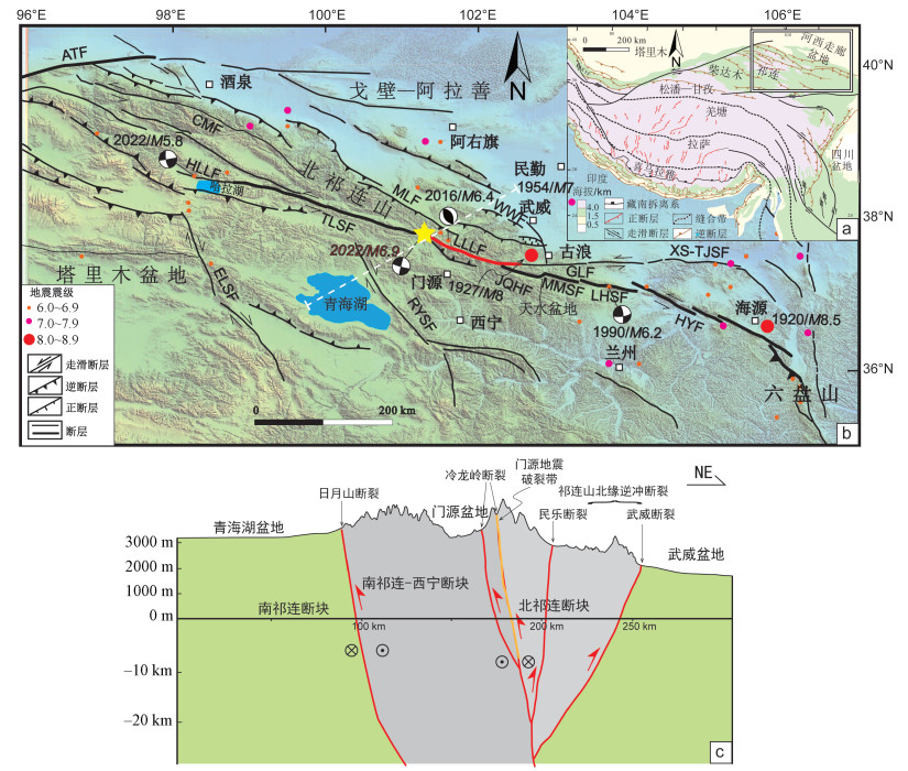
图 1 研究区区域地质图
a—青藏高原活动断裂构造纲要图(图中矩形框代表图b位置;据Li et al., 2015修改);b—青藏高原东北缘冷龙岭断裂及邻区区域构造简图(LLLF—冷龙岭断裂;JQHF—金强河断裂;MMSF—毛毛山断裂;LHSF—老虎山断裂;HYF—海源断裂;TLSF—托来山断裂;GLF—古浪断裂;XS-TJSF—香山-天景山断裂;CMF—昌马断裂;HLLF—哈拉湖断裂;MLF—民乐断裂;WWF—武威断裂;RYSF—日月山断裂;ELSF—鄂拉山断裂,ATF—阿尔金断裂;黄色五角星代表此次地震震中,白色虚线代表图c地质剖面位置、红色实线代表此次地震的发震断裂冷龙岭断裂带;据Guo et al., 2019a修改)、c—祁连山块体构造剖面示意图
Figure 1. Regional geological map of the study area
(a) Schematic tectonic map of the active faults in the Tibetan Plateau (modified after Li et al., 2015). The rectangular box in the figure represents the position of Fig. 1b; (b) Main active tectonics of the Lenglongling fault and adjacent region(modified after Guo et al., 2019a). The yellow star represents the epicenter of this earthquake, the white dotted line represents the position of the geological section in Fig. 1c, and the solid red line represents the seismogenic Lenglongling fault zone of this earthquake; (c) Geological profile of the Qilian Mountains block
LLLF-Lenglongling Fault; JQHF-Jinqianghe Fault; MMSF-Maomaoshan Fault; LHSF-Laohushan Fault; HYF-Haiyuan Fault; TLSF-Tuolaishan Fault; GLF-Gulang Fault; XS-TJSF-Xiangshan-Tianjingshan Fault; CMF-Changma Fault; HLLF-Hala Lake Fault; MLF-Minle Fault; WWF-Wuwei Fault; RYSF-Riyueshan Fault; ELSF-Elashan Fault; ATF-Altyn Tagh Fault
图 2 2022年1月8日青海门源MS 6.9地震地表破裂分布图
3a—7f代表下文图中照片位置;F1—F3分别代表南支破裂、北支主破裂和北支次级破裂
Figure 2. Surface rupture distribution map of the Menyuan MS 6.9 earthquake in Qinghai province on January 8, 2022
3a-7f represent the locations of the photos in the following figures; F1-F3 represent the south branch rupture, the north branch main rupture and the north branch secondary rupture, respectively (see discription in chap. 2.1)

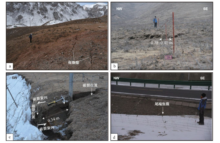
图 3 南支破裂(F1)野外照片(位置见图 2)
a—南支西侧尾端拉张区的左阶雁列张裂隙带;b—南支栅栏错动;c—南支次级破裂临近东端的左旋错断0.34 m;d—南支次级破裂临近东侧多条发散小裂缝
Figure 3. Field photos of the south branch rupture (F1) (see location in Fig. 2)
(a)The left-step en echelon of the tensile fracture zone at the west end of the south branch; (b) The fence dislocated by the south branch; (c) A 0.34 m sinistral displacement near the east end of the south branch; (d) Several small divergent fractures developed near the east side of the south branch

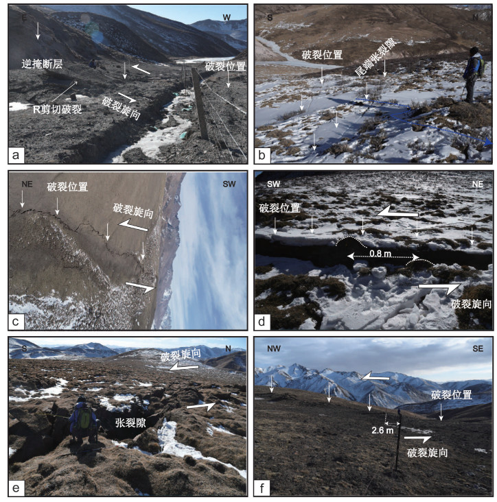
图 4 北支主破裂(F2)西段野外照片(位置见图 2)
a—破裂西段上R剪切破裂右阶部分发育的低角度逆冲断层,缩短量约91 cm;b—破裂西段的尾端呈马尾状撒开走向的张剪裂隙带,单条裂缝拉伸量和左旋走滑量都仅在厘米级;c—破裂西段无人机航拍照片;d—地表草坨左旋位错0.8 m;e—宏观震中附近最大张裂隙;f—宏观震中附近左旋错断栅栏约2.6 m
Figure 4. Field photos of the west section of the north branch main rupture (F2) (see location in Fig. 2)
(a)The low-angle thrust fault developed in the right stage of the R shear rupture in the west section of the rupture, with the shortening distance of about 91 cm; (b) A ponytail-shaped spreading tension-shear fracture zone At the tail end of the west section of the rupture, whose tensile amount and left-lateral strike-slip amount of a single crack are only at centimeter level; (c)Aerial photo of UAV in the west section of the rupture; (d)The sinistral dislocation of the grass mound reaches 0.8 m; (e)Maximum tensile fracture near the macroscopic epicenter of seismic network; (f)The 2.6 m sinistral dislocation of the fence near the macroscopic epicenter of the seismic network

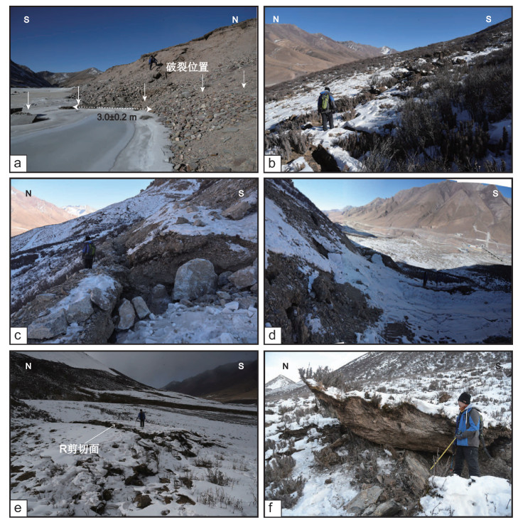
图 5 北支主破裂(F2)中段野外照片(位置见图 2)
a—沿整条破裂带最大左旋位移量3.0±0.2 m;b—左旋主破裂上张裂隙与挤压鼓包相间排列;c—冷龙岭大梁隧道附近南坡上大型张裂隙;d—冷龙岭大梁隧道附近边坡失稳与岩崩现象;e—左旋主破裂上的R剪切面;f—逆断层错断板岩
Figure 5. Field photos of the middle section of the north branch main rupture (F2) (see location in Fig. 2)
(a)The maximum sinistral displacement of 3.0±0.2 m along the whole fracture zone; (b)Tensile cracks and extrusion bulges alternately arranged in the sinistral main rupture; (c)Large tensile cracks on the south slope near the Lenglongling Daliang Tunnel; (d)Slope instability and rock collapse near the Lenglongling Daliang Tunnel; (e)R shear plane on the sinistral main rupture; (f)The slate dislocated by reverse fault

图 6 北支主破裂(F2)东段野外照片(位置见图 2)
a—北支东段上左阶拉分区走向96°的张裂隙;b—北支东段挤压鼓包,长宽高为3.8 m×4 m×1.6 m,对应走滑位移1.1~1.4 m;c—左旋剪切地表鼹鼠构造形迹;d—破裂东端的线性地表破裂形态
Figure 6. Field photos of the east section of the north branch main rupture (F2) (see location in Fig. 2)
(a)The extensional fissure striking 96°in the upper left step pull-apart area in the east section of the north branch; (b)The extrusion bulge in the east section of the north branch of 3.8 m in length, 4 m in width and 1.6 m in height, and the corresponding strike-slip displacement of 1.1~1.4 m; (c)Mole structural features in the sinistral shear surface; (d)Linear surface rupture pattern at the east end of the rupture

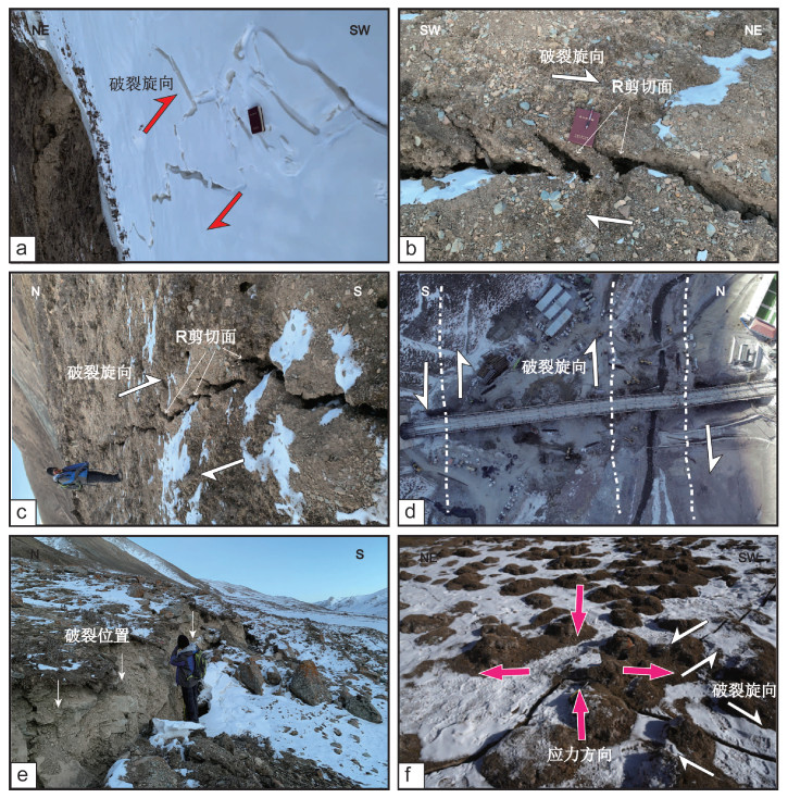
图 7 同震破裂带右旋张剪北支次级破裂(F3)野外照片(位置见图 2)
a—北支次级右旋破裂菱形拉分;b—北支次级右旋破裂R剪切面局部特征;c—北支次级右旋破裂R剪切面整体形态;d—右旋破裂错动铁路桥梁;e—北支右旋正断破裂上垂直断距约1.5 m的正断层崖;f—北支东段北侧右旋剪切破裂中的共轭剪裂隙
Figure 7. Field photos of the north branch secondary dextral rupture (F3) in the coseismic rupture zone (see location in Fig. 2)
(a)Diamond-shaped pull-apart of the north branch secondary dextral rupture; (b)Local features of the R shear plane of the north branch secondary dextral rupture; (c)Integral shape of the R shear plane of the north branch secondary dextral rupture; (d) Railway bridge dislocated by the dextral rupture; (e)The normal fault cliff with a vertical fault distance of about 1.5 m on the north branch normal dextral rupture; (f) Conjugate shear fissures in the dextral shear rupture on the north side of the east section of the north branch, and the pink arrow represents the strain direction

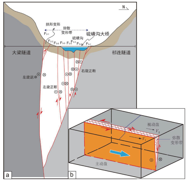
图 8 硫磺沟段破裂深部结构及右旋机理
a—错断硫磺沟桥隧的花状构造图(F2-1~F3-6代表次级分支破裂);b—右旋破裂成因模式图(V1、V2箭头分别代表主动盘和被动盘运动速度;主动盘(南盘)向东挤出,由于块体内部运动速度差异导致左旋主断层上发育右旋断层,两盘之间为转换变形区;蓝色曲线表示地表标志物拖曳变形)
Figure 8. Diagrams showing the deep structure and dextral rupture mechanism of the ruptures in the Liuhuanggou section
(a)Flower-like structure of the dislocated Liuhuanggou bridge tunnel; F2-1~F3-6 represent the secondary branch of the rupture; (b) Genetic model of the dextral rupture. V1 and V2 represent the velocity of the active fault wall and the passive fault wall, respectively; The active fault wall (south fault wall) is extruded eastward. Due to the velocity difference inside the block, the dextral fault is developed on the sinistral main fault, and there is a transition zone for the deformation between the two fault walls; The blue curve indicates the dragging deformation of the surface marker.
-
DENG Q D, CHENG S P, MA J, et al., 2014. Seismic activities and earthquake potential in the Tibetan Plateau[J]. Chinese Journal of Geophysics, 57(7): 2025-2042. (in Chinese with English abstract) http://en.cnki.com.cn/Article_en/CJFDTotal-DQWX201407001.htm GAI H L, YAO S H, YANG L P, et al., 2021. Characteristics and causes of coseismic surface rupture triggered by the "5.22" MS7.4 Earthquake in Maduo, Qinghai, and their significance[J]. Journal of Geomechanics, 27(6): 899-912. (in Chinese with English abstract) GAO R, WANG H Y, WANG C S, et al., 2011. Lithospheric deformation shortening of the northeastern Tibetan Plateau: evidence from reprocessing of deep seismic reflection data[J]. Acta Geoscientia Sinica, 32(5): 513-520. (in Chinese with English abstract) GAUDEMER Y, TAPPONNIER P, MEYER B, et al., 1995. Partitioning of crustal slip between linked, active faults in the eastern Qilian Shan, and evidence for a major seismic gap, the 'Tianzhu gap', on the western Haiyuan Fault, Gansu (China)[J]. Geophysical Journal International, 120(3): 599-645, doi: 10.1111/j.1365-246X.1995.tb01842.x. GUO A N, LI X, BAI X J, et al., 2016. The Menyuan, Qinghai MS6.4 Earthquake on 21 January 2016 and its related parameters[J]. China Earthquake Engineering Journal, 38(1): 150-158. (in Chinese with English abstract) GUO P, HAN Z J, DONG S P, et al., 2019a. Surface rupture and slip distribution along the Lenglongling fault in the NE Tibetan Plateau: implications for faulting behavior[J]. Journal of Asian Earth Sciences, 172: 190-207, doi: 10.1016/j.jseaes.2018.09.008. GUO P, HAN Z J, MAO Z B, et al., 2019b. Paleoearthquakes and rupture behavior of the Lenglongling fault: Implications for seismic hazards of the northeastern margin of the Tibetan Plateau[J]. Journal of Geophysical Research: Solid Earth, 124(2): 1520-1543, doi: 10.1029/2018JB016586. HE W G, LIU B C, YUAN D Y, et al., 2000. Research on slip rates of the Lenglongling active fault zone[J]. Northwestern Seismological Journal, 22(1): 90-97. (in Chinese with English abstract) HE W G, YUAN D Y, GE W P, et al., 2010. Determination of the slip rate of the Lenglongling fault in the middle and eastern segments of the Qilian mountain active fault zone[J]. Earthquake, 30(1): 131-137. (in Chinese with English abstract) HU C Z, YANG P X, LI Z M, et al., 2016. Seismogenic mechanism of the 21 January 2016 Menyuan, Qinghai MS6.4 earthquake[J]. Chinese Journal of Geophysics, 59(5): 1637-1646. (in Chinese with English abstract) JIA S X, ZHANG X K, 2008. Study on the crust phases of deep seismic sounding experiments and fine crust structures in the northeast margin of Tibetan plateau[J]. Chinese Journal of Geophysics, 51(5): 1431-1443. (in Chinese with English abstract) http://www.oalib.com/paper/1568190 JIANG W L, LI Y S, TIAN Y F, et al., 2017. Research of seismogenic structure of the menyuan MS6.4 earthquake on January 21, 2016 in Lenglongling area of ne Tibetan Plateau[J]. Seismology and Geology, 39(3): 536-549. (in Chinese with English abstract) LASSERRE C, MOREL P H, GAUDEMER Y, et al., 1999. Postglacial left slip rate and past occurrence of M≥8 earthquakes on the Western Haiyuan Fault, Gansu, China[J]. Journal of Geophysical Research: Solid Earth, 104(B8): 17633-17651, doi: 10.1029/1998JB900082. LI Y L, WANG C S, DAI J E, et al., 2015. Propagation of the deformation and growth of the Tibetan-Himalayan orogen: a review[J]. Earth-Science Reviews, 143: 36-61, doi: 10.1016/j.earscirev.2015.01.001 LIU Z, LI B, HE K, et al., 2020. An analysis of dynamic response characteristics of the Yigong landslide in Tibet under strong earthquake[J]. Journal of Geomechanics, 26(4): 471-480. (in Chinese with English abstract) MA B Q, LI D W, 2008. Stages of the neotectonic movement of the Menyuan basin in the middle segment of the Qilian mountains[J]. Journal of Geomechanics, 14(3): 201-211. (in Chinese with English abstract) http://en.cnki.com.cn/Article_en/CJFDTOTAL-DZLX200803004.htm PAN J W, BAI M K, LI C, et al., 2021. Coseismic surface rupture and seismogenic structure of the 2021-05-22 Maduo (Qinghai) MS7.4 earthquake[J]. Acta Geologica Sinica, 95(6): 1655-1670. (in Chinese with English abstract) PELTZER G, TAPPONNIER P, 1988. Formation and evolution of strike-slip faults, rifts, and basins during the India-Asia Collision: an experimental approach[J]. Journal of Geophysical Research: Solid Earth, 93(B12): 15085-15117, doi: 10.1029/JB093iB12p15085. TAPPONNIER P, XU Z Q, ROGER F, et al., 2001. Oblique stepwise rise and growth of the Tibet Plateau[J]. Science, 294(5547): 1671-1677, doi: 10.1126/science.105978. WELLS D L, COPPERSMITH K J, 1994. New empirical relationships among magnitude, rupture length, rupture width, rupture area, and surface displacement[J]. Bulletin of the Seismological Society of America, 84(4): 974-1002, doi: 10.1785/BSSA0840040974. WU Z H, ZHAO G M, 2013. The earthquake prediction status and related problems: a review[J]. Geological Bulletin of China, 32(10): 1493-1512. (in Chinese with English abstract) http://en.cnki.com.cn/Article_en/CJFDTOTAL-ZQYD201310002.htm WU Z H, ZHAO G M, LONG C X, et al., 2014. The seismic hazard assessment around South-East area of Qinghai-Xizang plateau: a preliminary results from active tectonics system analysis[J]. Acta Geologica Sinica, 88(8): 1401-1416. (in Chinese with English abstract) WU Z H, ZHAO G M, LIU J, 2016. Tectonic genesis of the 2015 Ms8.1 Nepal great earthquake and its influence on future strong earthquake tendency of Tibetan Plateau and its adjacent region[J]. Acta Geologica Sinica, 90(6): 1062-1085. (in Chinese with English abstract) http://www.researchgate.net/publication/324493674_2015niannipoerMs81dezhengouzaochengyinjiduiqingcanggaoyuanjilinquweilaiqiangzhenqushideyingxiang2015175 XIA Y, 2015. The faulting tectonics and it's evolution in Tuolai river of Qilian mountain since the Mesozoic[D]. Beijing: China University of Geosciences (Beijing). (in Chinese) YUAN D Y, LIU B C, LV T Y, et al., 1998. Study on the segmentation in east segment of the northern Qilianshan fault zone[J]. Northwestern Seismological Journal, 20(4): 27-34. (in Chinese with English abstract) http://en.cnki.com.cn/Article_en/CJFDTOTAL-ZBDZ199804003.htm YUAN D Y, ZHANG P Z, LIU B C, et al., 2004. Geometrical imagery and tectonic transformation of late quaternary active tectonics in northeastern margin of Qinghai-Xizang Plateau[J]. Acta Geologica Sinica, 78(2): 270-278. (in Chinese with English abstract) YUAN D Y, GE W P, CHEN Z W, et al., 2013. The growth of northeastern Tibet and its relevance to large-scale continental geodynamics: a review of recent studies[J]. Tectonics, 32(5): 1358-1370, doi: 10.1002/tect.20081. ZHAO G M, WU Z H, LIU J, 2020. The types, characteristics and mechanism of seismic migration[J]. Journal of Geomechanics, 26(1): 13-32. (in Chinese with English abstract) ZHAO Q, WANG S X, JIANG F Y, et al., 2017. Coseismic deformation field and fault slip distribution of the 2016 Qinghai Menyuan MW5.9 earthquake from InSAR measurement[J]. Earthquake, 37(2): 96-105. (in Chinese with English abstract) ZHENG W J, YUAN D Y, HE W G, 2004. Characteristics of Palaeo-earthquake activity along the active Tianqiaogou-Huangyangchuan fault on the eastern section of the Qilianshan mountains[J]. Seismology and Geology, 26(4): 645-657. (in Chinese with English abstract) ZHOU C J, WU Z H, NIMA C R, et al., 2014. Structural analysis of the co-seismic surface ruptures associated with the Yushu Ms7.1 earthquake, Qinghai Province[J]. Geological Bulletin of China, 33(4): 551-566. (in Chinese with English abstract) 邓起东, 程绍平, 马冀, 等, 2014. 青藏高原地震活动特征及当前地震活动形势[J]. 地球物理学报, 57(7): 2025-2042. https://www.cnki.com.cn/Article/CJFDTOTAL-DQWX201407001.htm 盖海龙, 姚生海, 杨丽萍, 等, 2021. 青海玛多"5·22"MS7.4级地震的同震地表破裂特征、成因及意义[J]. 地质力学学报, 27(6): 899-912. doi: 10.12090/j.issn.1006-6616.2021.27.06.073 高锐, 王海燕, 王成善, 等, 2011. 青藏高原东北缘岩石圈缩短变形: 深地震反射剖面再处理提供的证据[J]. 地球学报, 32(5): 513-520. doi: 10.3975/cagsb.2011.05.01 郭安宁, 李鑫, 白雪见, 等, 2016. 2016年1月21日青海门源6.4级地震及相关参数[J]. 地震工程学报, 38(1): 150-158. doi: 10.3969/j.issn.1000-0844.2016.01.0150 何文贵, 刘百篪, 袁道阳, 等, 2000. 冷龙岭活动断裂的滑动速率研究[J]. 西北地震学报, 22(1): 90-97. https://www.cnki.com.cn/Article/CJFDTOTAL-ZBDZ200001017.htm 何文贵, 袁道阳, 葛伟鹏, 等, 2010. 祁连山活动断裂带中东段冷龙岭断裂滑动速率的精确厘定[J]. 地震, 30(1): 131-137. doi: 10.3969/j.issn.1000-3274.2010.01.015 胡朝忠, 杨攀新, 李智敏, 等, 2016. 2016年1月21日青海门源6.4级地震的发震机制探讨[J]. 地球物理学报, 59(5): 1637-1646. https://www.cnki.com.cn/Article/CJFDTOTAL-DQWX201605009.htm 嘉世旭, 张先康, 2008. 青藏高原东北缘深地震测深震相研究与地壳细结构[J]. 地球物理学报, 51(5): 1431-1443. doi: 10.3321/j.issn:0001-5733.2008.05.016 姜文亮, 李永生, 田云锋, 等, 2017. 冷龙岭地区2016年青海门源6.4级地震发震构造特征[J]. 地震地质, 39(3): 536-549. doi: 10.3969/j.issn.0253-4967.2017.03.007 刘铮, 李滨, 贺凯, 等, 2020. 地震作用下西藏易贡滑坡动力响应特征分析[J]. 地质力学学报, 26(4): 471-480. doi: 10.12090/j.issn.1006-6616.2020.26.04.040 马保起, 李德文, 2008. 祁连山中段门源盆地新构造运动的阶段划分[J]. 地质力学学报, 14(3): 201-211. doi: 10.3969/j.issn.1006-6616.2008.03.002 潘家伟, 白明坤, 李超, 等, 2021. 2021年5月22日青海玛多MS7.4地震地表破裂带及发震构造[J]. 地质学报, 95(6): 1655-1670. doi: 10.3969/j.issn.0001-5717.2021.06.001 吴中海, 赵根模, 2013. 地震预报现状及相关问题综述[J]. 地质通报, 32(10): 1493-1512. doi: 10.3969/j.issn.1671-2552.2013.10.002 吴中海, 赵根模, 龙长兴, 等, 2014. 青藏高原东南缘现今大震活动特征及其趋势: 活动构造体系角度的初步分析结果[J]. 地质学报, 88(8): 1401-1416. https://www.cnki.com.cn/Article/CJFDTOTAL-DZXE201408004.htm 吴中海, 赵根模, 刘杰, 2016. 2015年尼泊尔Ms8.1地震构造成因及对青藏高原及邻区未来强震趋势的影响[J]. 地质学报, 90(6): 1062-1085. doi: 10.3969/j.issn.0001-5717.2016.06.002 夏阳, 2015. 祁连山托来河地区中生代以来的断裂构造及其演化[D]. 北京: 中国地质大学(北京). 袁道阳, 刘百篪, 吕太乙, 等, 1998. 北祁连山东段活动断裂带的分段性研究[J]. 西北地震学报, 20(4): 27-34. https://www.cnki.com.cn/Article/CJFDTOTAL-ZBDZ199804003.htm 袁道阳, 张培震, 刘百篪, 等, 2004. 青藏高原东北缘晚第四纪活动构造的几何图像与构造转换[J]. 地质学报, 78(2): 270-278. doi: 10.3321/j.issn:0001-5717.2004.02.017 赵根模, 吴中海, 刘杰, 2020. 地震迁移的类型、特征及机制讨论[J]. 地质力学学报, 26(1): 13-32. doi: 10.12090/j.issn.1006-6616.2020.26.01.002 赵强, 王双绪, 蒋锋云, 等, 2017. 利用InSAR技术研究2016年青海门源MW5.9地震同震形变场及断层滑动分布[J]. 地震, 37(2): 96-105. https://www.cnki.com.cn/Article/CJFDTOTAL-DIZN201702009.htm 郑文俊, 袁道阳, 何文贵, 2004. 祁连山东段天桥沟: 黄羊川断裂古地震活动习性研究[J]. 地震地质, 26(4): 645-657. doi: 10.3969/j.issn.0253-4967.2004.04.011 周春景, 吴中海, 尼玛次仁, 等, 2014. 青海玉树Ms7.1级地震同震地表破裂构造[J]. 地质通报, 33(4): 551-566. doi: 10.3969/j.issn.1671-2552.2014.04.011 -

 下载:
下载:


计量
- 文章访问数: 3253
- HTML全文浏览量: 742
- PDF下载量: 410
- 被引次数: 0
