

Characteristics and causes of coseismic surface rupture triggered by the "5.22" MS 7.4 Earthquake in Maduo, Qinghai, and their significance
-
摘要: 2021年5月22日2时4分在青海省果洛藏族州玛多县境内发生MS7.4级地震,此次玛多MS7.4级地震是2008年汶川MS8.0级大地震之后中国震级最大的一次地震,及时查明其同震地表破裂展布及特征,对于正确认识发震构造和区域防震减灾具有重要意义。根据震后现场调查,结合高分辨率卫星遥感图像的解译分析、余震数据和典型地震地表破裂的无人机低空摄影测量等结果,初步获得了此次地震6处典型地震地表破裂的特征。结果发现:此次玛多地震的地表破裂主要沿已知的东昆仑断裂带的南侧分支断裂昆仑山口-江错断裂的东南段分布,分析表明其中的江错断裂应是此次地震的发震断层;同震破裂的西段总体走向275°~300°,主要表现为挤压鼓包和雁列式张裂隙的斜列组合,其中江错贡麻段至江多村段出现了明显的1.4~0.8 m的垂直位移,指示该段可能具有较明显的正断层成分;中部黄河乡段主要由一系列呈左阶斜列的北西向P剪切裂缝和右阶雁行排列的北东向张裂隙构成,走滑位移较小;而东段地表破裂出现了多个分支,其中北支昌马河段主要由一系列雁行排列的张裂隙组成,总体走向为260°,与断裂西段的走向明显不同;地震造成的最大左旋位移出现在西段的错尔加拉破裂段,约2.8 m,指示此次地震地表破裂带的走滑位移主要呈从西向东的单侧扩展-衰减特征。考虑到此次玛多地震出现在东昆仑主干断裂南侧的巴颜喀拉地块内部,表明该地块内部具有发生7级以上大地震的能力,因此,巴颜喀拉地块内部强震活动的孕震条件和机理应该是未来需要进一步关注的科学问题。
-
关键词:
- 玛多MS7.4级地震 /
- 地震地表破裂 /
- 江错断裂 /
- 东昆仑断裂带 /
- 巴颜喀拉块体
Abstract: An MS 7.4 earthquake occurred in Maduo County, Guoluo Tibetan Prefecture, Qinghai Province at 02:04 on May 22, 2021(Beijing time), which is the largest one in China after the 2008 Wenchuan MS 8.0 earthquake. Finding out the distribution and characteristics of its coseismic surface rupture in time is of great significance for the identification of seismogenic structure, regional earthquake prevention and disaster reduction. Combining the post-earthquake field investigation with the results from the interpretation and analysis of high-resolution satellite remote sensing images, aftershock data and UAV low altitude photogrammetry, we got a preliminary judgment on the characteristics of six typical seismic surface ruptures. Firstly, the surface rupture caused by the Maduo earthquake is mainly distributed along the southeastern segment of the known South Branch of the East Kunlun fault zone, the kunlunshankou-Jiangcuo fault. It indicates that the Jiangcuo fault should be the seismogenic fault of the earthquake. Secondly, the western segment of the coseismic rupture with an overall strike of 275°~300°, is mainly manifested as an inclined combination of compressive bulges and echelon tensile fractures. There is a significant vertical displacement of 1.4~0.8 m between the Jiangcuogongma section and the Jiangduocun section, indicating that the western segment may have obvious normal fault components. The huanghexiang section in the middle is mainly composed of a series of NW-trending P shear fractures with left-order oblique and NE-trending tensile fractures with right-order en echelon, with small strike slip displacements. The Changma reach of the North Branch is mainly composed of a series of en echelon fractures, with the overall strike of 260°, The strike of the fault is obviously different from that of the western segment of the fault. Thirdly, the maximum left lateral displacement caused by the earthquake occurred in the Cuoerjiala rapture section of the western segment, about 2.8 m, indicating that the strike slip displacement of the surface fracture zone of the earthquake is mainly characterized by unilateral expansion attenuation from west to East. The fact that the Maduo earthquake occurred in the Bayan Har block on the south side of the East Kunlun main fault demonstrate the possibility of earthquake with magnitude 7 or above in this block. Therefore the seismogenic conditions and mechanism of strong earthquake activity in the Bayan Har block should be a scientific issue that needs further attention. -

图 1 玛多MS7.4级地震区域地震构造图(余震目录来自青海省地震台网)
a—巴颜喀拉块体历史强震分布图; b—玛多MS 7.4级地震余震分布及典型地表破裂考察点分布图
Figure 1. Regional seismic structural map of the Maduo MS7.4 earthquake
(a)Distribution map of historical strong earthquakes occurred in the Bayan Har block; (b)Distribution of aftershocks and investigation points of typical surface rupture of the MS7.4 Maduo earthquake
The aftershock catalog comes from the Qinghai Seismic Network.
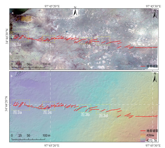
图 2 错尔加拉段地表破裂解译图
a—正射影像图; b—数字高程模型
Figure 2. Interpretation of surface rupture of the Cuoerjiala section
(a) Orthophoto; (b) Digital elevation model

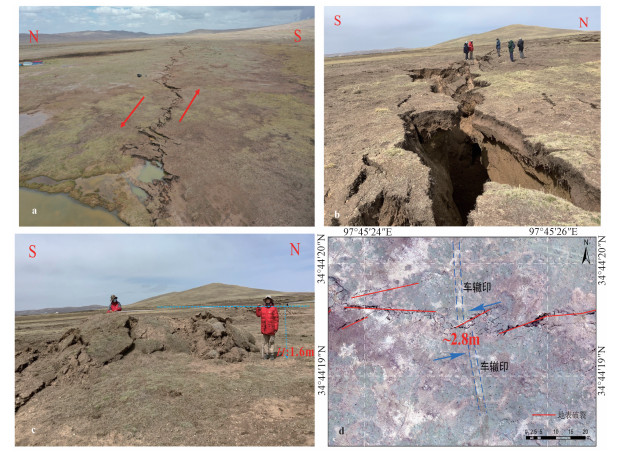
图 3 错尔加拉段地表破裂及同步左旋位移特征
a—指示左旋走滑的地表破裂带; b—北东向的大型张裂缝; c—高约1.6 m的北西向挤压鼓包; d—车辙左旋位错约2.8 m
Figure 3. Photos showing the features of surface rupture and synchronous left-handed displacement of the Cuoerjiala section
(a)Surface rupture zone indicating left-handed strike-slip; (b) Large-scale NE-trending crack; (c)A ~1.6 m-high NW-trending squeeze bulge; (d) A ~2.8 m left-handed rut dislocation

图 4 鄂陵湖南段地表破裂解译图
a—正射影像图; b—数字高程模型
Figure 4. Interpretation of the surface rupture in the southern segment of the Elinghu section
(a) Orthophoto; (b)Digital elevation model

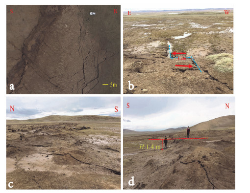
图 5 鄂陵湖南段地表破裂及同步左旋位移特征
a—指示近东西向左旋剪切作用的右阶雁行张裂缝; b—宽约1.7m的北东向张裂隙; c—左阶斜列分布的挤压鼓包; d—车辙被左旋位错约1.4 m
Figure 5. Photos showing the features of surface rupture and synchronous left-handed displacement in the southern segment of the Elinghu section
(a)Right-order en echelon crack indicating left-handed shearing action from near east to west; (b) A ~1.7 m-wide NE-trending tensile fracture; (c) Compressive bulges distributed diagonally in the left order; (d) A rut dislocated by left-handed is about 1.4 m

图 6 江错贡麻段地表破裂解译图
a—正射影像图; b—数字高程模型
Figure 6. Interpretation of the surface rupture in the Jiangcuogongma section
(a) Orthophoto; (b) Digital elevation model

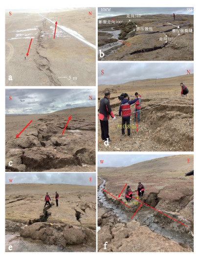
图 7 江错贡麻段地震地表破裂及同步左旋位移特征
a—张裂隙; b—左旋位错冲沟约1.2 m; c—断层陡坎; d—高约1.4 m的断层陡坎
Figure 7. Photos showing the features of seismic surface ruptures and synchronous left-handed displacement of the Jiangcuogongma segment
(a) Tensile fractures; (b) A ~1.2 m-wide left-handed dislocation gully; (c) Fault ridges; (d) A ~1.4 m-high fault ridge

图 8 江多村段地表破裂解译图
a—无人机航摄的正射影像图; b—数字高程模型(指示断层北盘存在相对抬升)
Figure 8. Interpretation of the surface ruptures in the Jiangduocun section
(a) Orthophoto; (b) Digital elevation model

图 9 江多村段地震地表破裂及同步左旋位移特征
a—指示左旋走滑的雁列挤压鼓包及张裂缝; b—在破裂右阶斜列部位发育的北西向挤压脊; c—宽约20 m的地表破裂; d—指示断层北侧抬升的约0.8 m高断坎; e—右阶雁列的北东向张裂缝; f—左旋位错冲沟约1.1 m
Figure 9. Photos showing the features of seismic surface ruptures and synchronous left-handed displacement of the Jiangduocun section
(a) En echelon compressive bulges and tensile fractures indicating left-handed strike-slip; (b) NW-trending compressive ridge developed in the right-order oblique row of the rupture; (c) A ~20 m-wide surface rupture; (d) A ~0.8 m-high fault ridge indicating the uplift in the north side of the fault; (e) Right-order en echelon NE-trending tensile fractures; (f) A ~1.1 m-wide left-handed dislocation gully

图 10 黄河乡段地表破裂解译图
a—正射影像图; b—数字高程模型
Figure 10. Interpretation of surface ruptures in the Huanghexiang section
(a) Orthophoto; (b) Digital elevation model

图 11 黄河乡段地震地表破裂及同步左旋位移特征
a—破裂带中呈左阶雁行排列的P剪切裂缝; b—北西向P剪切裂缝与北东向张裂隙的交切现象; c—具左旋走滑性质的北西向P剪切裂缝; d—破裂带中的北西向P剪切裂缝将水泥杆左旋位错约20 cm
Figure 11. Photos showing the features of surface ruptures and synchronous left-handed displacement of the Huanghexiang section
(a) Left-order en echelon P shear fractures in the fracture zone; (b) Intersection between the NW-trending P shear fractures and NE-trending tensile fractures; (c) NW-trending P shear fractures with left-handed strike-slip; (d) NW-trending P shear fractures in the rupture zone left-handed dislocated the cement rod about 20 cm

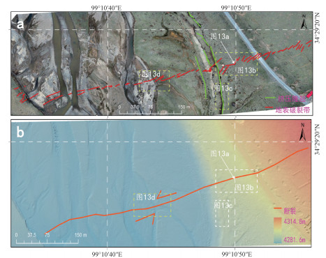
图 12 昌马河段地表破裂解译图
a—正射影像图; b—数字高程模型
Figure 12. Interpretation of surface ruptures in the Changmahe section
(a) Orthophoto; (b) Digital elevation model

图 13 昌马河段地表破裂及同步左旋位移特征
a—由拉张裂隙和小型鼓包雁列组合而成的地表破裂; b—由雁列鼓包和剪切裂缝组合而成的地表破裂; c—优尔曲东侧谷坡上出现的近南北向挤压鼓起带; d—地表剪切破裂左旋位错河床约1.1 m
Figure 13. Photos showing the features of surface ruptures and synchronous left-handed displacement in the Changmahe reach
(a) The surface ruptures formed by the combination of tensile fratures and small bulging en echelon row; (b) Surface ruptures formed by the combination of en echelon bulges and shear fractures; (c) A nearly NS-trending compressive bulge belt appeared on the valley slope on the east side of the Youerqu slope; (d) A surface shear fracture left-handed dislocated river bed about 1.1 m
-
BAI Y J, NI H Y, GE H, 2019. Advances in research on the geohazard effect of active faults on the southeastern margin of the Tibetan Plateau[J]. Journal of Geomechanics, 25(6): 1116-1128, doi: 10.12090/j.issn.1006-6616.2019.25.06.095.(in Chinese with English abstract) CHEN C Y, REN J W, MENG G J, et al., 2013. Division, deformation and tectonic implication of active blocks in the eastern segment of Bayan Harblock[J]. Chinese Journal of Geophysics, 56(12): 4125-4141, doi: 10.6038/cjg20131217.(in Chinese with English abstract). DAI H G, 1983. On the Dari earthquake of 1947 in the Qinghai province[J]. Northwestern Seismological Journal, 5(3): 71-77. (in Chinese with English abstract) http://en.cnki.com.cn/Article_en/CJFDTOTAL-ZBDZ198303013.htm DENG Q D, 2007. Active tectonic map of China (1: 4 million) (attached CD)[M]. Beijing: Seismological Publishing House. (in Chinese) Department of Earthquake Disaster Prevention, National Earthquake Bureau, 1995. Catalogue of historical strong earthquakes in China[M]. Beijing: Seismological Press: 1-514 (in Chinese). FU B H, LIN A M, 2003. Spatial distribution of the surface rupture zone associated with the 2001 MS8.1 Central Kunlun earthquake, northern Tibet, revealed by satellite remote sensing data[J]. International Journal of Remote Sensing, 24(10): 2191-2198. doi: 10.1080/0143116031000075918 FU B H, AWATA Y, DU J G, et al., 2005. Late Quaternary systematic stream offsets caused by repeated large seismic events along the Kunlun fault, northern Tibet[J]. Geomorphology, 71(3-4): 278-292, doi: 10.1016/j.geomorph.2005.03.001. GUO J M, LIN A M, SUN G Q, et al., 2007. Surface ruptures associated with the 1937 M 7.5 Tuosuo Lake and the 1963 M7.0 Alake Lake earthquakes and the paleoseismicity along the Tuosuo Lake segment of the Kunlun fault, northern Tibet[J]. Bulletin of the Seismological Society of America, 97(2): 474-496, doi: 10.1785/0120050103. JIANG W L, XIE X S, 2006. Characteristics of segments of surface ruptures of strong earthquakes along the East Kunlun active fault zone[J]. Chinese Journal of Geomechanics, 12(2): 132-139. (in Chinese with English abstract) LI H B, FU X F, VAN DER WOERD J, et al., 2008. Co-seisimic surface rupture and dextral-slip oblique thrusting of the MS8.0 Wenchuan earthquake[J]. Acta Geologica Sinica, 82(12): 1623-1643. (in Chinese with English abstract) LI H B, PAN J W, SUN Z M, et al., 2015. Seismogenic structure and surface rupture characteristics of the 2014 MS7.3 Yutian earthquake[J]. Acta Geologica Sinica, 89(1): 180-194. (in Chinese with English abstract) LI H B, PAN J W, SUN Z M, et al., 2021. Continental tectonic deformation and seismic activity: a case study from the Tibetan Plateau[J]. Acta Geologica Sinica, 95(1): 194-213, doi: 10.19762/j.cnki.dizhixuebao.2021051.(in Chinese with English abstract) LI J J, ZHANG J L, CAI Y Y, 2017. Investigation of historical earthquakes, paleo-earthquakes and seismic gap in the eastern Kunlun fault zone[J]. Earthquake, 37(1): 103-111. (in Chinese with English abstract) http://en.cnki.com.cn/Article_en/CJFDTOTAL-DIZN201701011.htm LIANG M J, ZHOU R J, YAN L, et al., 2014. The relationships between neotectonic activity of the middle segment of Dari fault and its geomorphological response, Qinghai Province, China[J]. Seismology and Geology, 36(1): 28-38. (in Chinese with English abstract) http://www.bloodjournal.org/content/73/1/141.full.pdf LIANG M J, YANG Y, DU F, et al., 2020. Late quaternary activity of the central segment of the Dari fault and restudy of the surface rupture zone of the 1947 M7 3/4 Dari earthquake, Qinghai Province[J]. Seismology and Geology, 42(3): 703-714. (in Chinese with English abstract) LIN A M, FU B H, GUO J M, et al., 2002. Co-seismic strike-slip and rupture length produced by the 2001 MS8.1 central Kunlun earthquake[J]. Science, 296(5575): 2015-2017. doi: 10.1126/science.1070879 LIN A M, RAO G, JIA D, et al., 2011. Co-seismic strike-slip surface rupture and displacement produced by the 2010 MW 6.9 Yushu earthquake, China, and implications for Tibetan tectonics[J]. Journal of Geodynamics, 52(3-4): 249-259. doi: 10.1016/j.jog.2011.01.001 PAN J W, BAI M K, LI C, et al., 2021. Coseismic surface rupture and seismogenic structure of the 2021-05-22 Maduo (Qingha)MS7.4 earthquake[J]. Acta Geologica Sinica, 95(6): 1655-1670, doi: 10.3969/j.issn.0001-5717.2021.06.001.(in Chinese with English abstract) SUN X Z, XU X W, CHEN L C, et al., 2012. Surface rupture features of the 2010 Yushu earthquake and its tectonic implication[J]. Chinese Journal of Geophysics, 55(1): 155-170, doi: 10.6038/j.issn.0001-5733.2012.01.015.(in Chinese with English abstract) TAPPONNIER P, MOLNAR P, 1977. Active faulting and tectonics in China[J]. Journal of Geophysical Research, 82(20): 2905-2930. doi: 10.1029/JB082i020p02905 WANG S Y, 1999. Catalogue of modern earthquakes in China[M]. Beijing: China Science and Technology Press. (in Chinese) WANG W L, FANG L H, WU J P, et al., 2021. Aftershock sequence relocation of the 2021 MS7.4 Maduo Earthquake, Qinghai, China[J]. Science China Earth Sciences, 64(8): 1371-1380, doi: 10.1007/s11430-021-9803-3.(in Chinese with English abstract) WEN X Z, YI G X, XU X W, 2007. Background and precursory seismicities along and surrounding the Kunlun fault before the MS8.1, 2001, Kokoxili earthquake, China[J]. Journal of Asian Earth Sciences, 30(1): 63-72. doi: 10.1016/j.jseaes.2006.07.008 WEN X Z, 2018. The 2008 Wenchuan, 2013 Lushan and 2017 Jiuzhaigou earthquakes, Sichuan, in the last more than one thousand years of rupture history of the eastern margin of the Bayan Har block[J]. Acta Seismologica Sinica, 40(3): 255-267. (in Chinese with English abstract) http://en.cnki.com.cn/Article_en/CJFDTOTAL-DZXB201803002.htm WU Z H, ZHAO G M, LONG C X, et al., 2014. The seismic hazard assessment around south-east area of Qinghai-Xizang Plateau: A preliminary results from active tectonics system analysis[J]. Acta Geologica Sinica, 88(8): 1401-1416. (in Chinese with English abstract) WU Z H, ZHAO G M, LIU J, 2016. Tectonic genesis of the 2015 MS8.1 Nepal great earthquake and its influence on future strong earthquake tendency of Tibetan Plateau and its adjacent region[J]. Acta Geologica Sinica, 90(6): 1062-1085. (in Chinese with English abstract) XIONG R W, REN J W, ZHANG J L, et al., 2010. Late Quaternary active characteristics of the Gande segment in the Maduo-Gande fault zone[J]. Earthquake, 30(4): 65-73. (in Chinese with English abstract) XU X W, CHEN W B, MA W T, et al., 2002. Surface rupture of the Kunlunshan earthquake (MS8.1), northern Tibetan plateau, China[J]. Seismological Research Letters, 73(6): 884-892. doi: 10.1785/gssrl.73.6.884 XU X W, CHEN W B, YU G H, et al., 2002. Characteristic Features of the Hoh Sai Hu (Kunlunshan) Earthquake (MS8.1), Northern Tibetan Plateau, China[J]. Seismology and Geology, 24(1): 1-13. (in Chinese with English abstract) http://en.cnki.com.cn/Article_en/CJFDTOTAL-DZDZ200201000.htm XU X W, CHEN G H, WANG Q X, et al. 2017. Discussion on seismogenic structure of Jiuzhaigou earthquake and its implication for current strain state in the southeastern Qinghai-Tibet Plateau. Chinese J. Geophys, 60(10): 4018-4026, doi: 10.6038/cjg20171028.(in Chinese with English abstract) YUAN D Y, ZHANG P Z, LIU B C, et al., 2004. Geometrical imagery and tectonic transformation of late quaternary active tectonics in northeastern margin of Qinghai-Xizang Plateau[J]. Acta Geologica Sinica, 78(2): 270-278. (in Chinese with English abstract) YUAN Z D, LIU-ZENG J, LI X, et al., 2021. Detailed mapping of the surface rupture of the 12 February 2014 Yutian MS7.3 earthquake, Altyn Tagh fault, Xinjiang, China[J]. Science China Earth Sciences, 64(1): 127-147, doi: 10.1007/s11430-020-9673-6.(in Chinese with English abstract) ZHAN Y, LIANG M J, SUN X Y, et al., 2021. Deep structure and seismogenic pattern of the 2021. 5.22 Madoi(Qinghai) MS7.4 earthquake[J]. Chinese Journal of Geophysics, 64(7): 2232-2252. (in Chinese with English abstract) ZHANG G M, TIAN Q J, WANG H, 2003. Strong earthquake activities in Kekexili-east Kunlun Mountains active fault zone, northwest China[J]. Earth Science Frontiers, 10(1): 39-46. (in Chinese with English abstract) http://en.cnki.com.cn/Article_en/CJFDTOTAL-DXQY200301007.htm ZHANG P Z, DENG Q D, ZHANG G M, et al., 2003. Active tectonic blocks and strong earthquakes in the continent of China[J]. Science in China Series D: Earth Sciences, 33(S1): 12-20. (in Chinese with English abstract) http://d.wanfangdata.com.cn/Periodical_zgkx-ed2003z2002.aspx ZHANG P Z, SHEN Z K, WANG M, et al., 2004. Continuous deformation of the Tibetan Plateau from global positioning system data[J]. Geology, 32(9): 809-812. doi: 10.1130/G20554.1 ZHANG P Z, MOLNAR P, XU X W, 2007. Late Quaternary and present-day rates of slip along the Altyn Tagh Fault, northern margin of the Tibetan Plateau[J]. Tectonics, 26(5): TC5010. http://citeseerx.ist.psu.edu/viewdoc/download;jsessionid=97E870F7460A2603137A62D4B67E9E27?doi=10.1.1.421.9331&rep=rep1&type=pdf ZHANG P Z, DENG Q D, ZHANG Z Q, et al., 2013. Active faults, earthquake hazards and associated geodynamic processes in continental China[J]. Scientia Sinica Terrae, 43(10): 1607-1620. (in Chinese with English abstract) doi: 10.1360/zd-2013-43-10-1607 ZHANG Y M, LI M F, MENG Y Q, et al., 1996. Research on fault activities and their seismogeological implication in Bayankala Mountain area[J]. Research on Active Fault, 5: 154-171 (in Chinese with English abstract). ZHAO G Z, UNSWORTH M J, ZHAN Y, et al., 2012. Crustal structure and rheology of the Longmenshan and WenchuanMW 7.9 earthquake epicentral area from magnetotelluric data[J]. Geology, 40(12): 1139-1142. doi: 10.1130/G33703.1 ZHENG W J, YUAN D Y, ZHANG P Z, et al., 2016. Tectonic geometry and kinematic dissipation of the active faults in the northeastern Tibetan Plateau and their implications for understanding northeastward growth of the Plateau[J]. Quaternary Sciences, 36(4): 775-788. (in Chinese with English abstract) http://www.dsjyj.com.cn/EN/Y2016/V36/I4/775 ZHENG W J, ZHANG P Z, YUAN D Y, et al., 2019. Basic characteristics of active tectonics and associamic processes in continental China[J]. Journal of Geomechanics, 25(5): 699-721 DOI: 10.12090/j.issn.1006-6616.2019.25.05.062.(in Chinese with English abstract) ZHOU C J, Wu Z H, NIMA T, et al., 2014. Qinghai Yushu MS7.1 magnitude earthquake with seismic surface rupture structure geological advisory, 2014, 33 (4): 551-566. (in Chinese with English abstract) 白永健, 倪化勇, 葛华, 2019. 青藏高原东南缘活动断裂地质灾害效应研究现状[J]. 地质力学学报, 25(6): 1116-1128, doi: 10.12090/j.issn.1006-6616.2019.25.06.095. 陈长云, 任金卫, 孟国杰, 等, 2013. 巴颜喀拉块体东部活动块体的划分、形变特征及构造意义[J]. 地球物理学报, 56(12): 4125-4141, doi: 10.6038/cjg20131217. 戴华光, 1983. 1947年青海达日7 3/4级地震[J]. 西北地震学报, 5(3): 711-77. https://www.cnki.com.cn/Article/CJFDTOTAL-ZBDZ198303013.htm 邓起东, 2007. 中国活动构造图(1: 400万)[M]. 北京: 地震出版社. 国家地震局震害防御司, 1995. 中国历史强震目录[M]. 北京: 地震出版社: 1-514. 江娃利, 谢新生, 2006. 东昆仑活动断裂带强震地表破裂分段特征[J]. 地质力学学报, 12(2): 132-139. doi: 10.3969/j.issn.1006-6616.2006.02.004 李海兵, 付小方, VAN DER WOERD J, 等, 2008. 汶川震(MS8.0)地表破裂及其同震右旋斜向逆冲作用[J]. 地质学报, 82(12): 1623-1643. doi: 10.3321/j.issn:0001-5717.2008.12.002 李海兵, 潘家伟, 孙知明, 等, 2015. 2014年于田MS7.3地震地表破裂特征及其发震构造[J]. 地质学报, 89(1): 180-194. https://www.cnki.com.cn/Article/CJFDTOTAL-DZXE201501014.htm 李海兵, 潘家伟, 孙知明, 等, 2021. 大陆构造变形与地震活动: 以青藏高原为例[J]. 地质学报, 95(1): 194-213, doi: 10.19762/j.cnki.dizhixuebao.2021051. 李建军, 张军龙, 蔡瑶瑶, 2017. 东昆仑断裂带历史地震、古地震及地震空区讨论[J]. 地震, 37(1): 103-111. doi: 10.3969/j.issn.1000-3274.2017.01.011 梁明剑, 周荣军, 闫亮, 等, 2014. 青海达日断裂中段构造活动与地貌发育的响应关系探讨[J]. 地震地质, 36(1): 28-38. doi: 10.3969/j.issn.0253-4967.2014.01.003 梁明剑, 杨耀, 杜方, 等, 2020. 青海达日断裂中段晚第四纪活动性与1947年M7 3/4地震地表破裂带再研究[J]. 地震地质, 42(3): 703-714. doi: 10.3969/j.issn.0253-4967.2020.03.011 潘家伟, 白明坤, 李超, 等, 2021. 2021年5月22日青海玛多MS7.4地震地表破裂带及发震构造[J]. 地质学报, 95(6): 1655-1670, doi: 10.3969/j.issn.0001-5717.2021.06.001. 孙鑫喆, 徐锡伟, 陈立春等, 2012. 2010年玉树地震地表破裂带典型破裂样式及其构造意义[J]. 地球物理学报, 55(1): 155-170, doi: 10.6038/j.issn.0001-5733.2012.01.015. 汪素云, 1999. 中国近代地震目录[M]. 北京: 中国科学技术出版社. 王未来, 房立华, 吴建平, 等, 2021. 2021年青海玛多MS7.4地震序列精定位研究[J]. 中国科学: 地球科学, 51(7): 1193-1202, doi: 10.1360/SSTe-2021-0149. 闻学泽, 2018. 巴颜喀拉块体东边界千年破裂历史与2008年汶川、2013年芦山和2017年九寨沟地震[J]. 地震学报, 40(3): 255-267. https://www.cnki.com.cn/Article/CJFDTOTAL-DZXB201803002.htm 吴中海, 赵根模, 龙长兴, 等, 2014. 青藏高原东南缘现今大震活动特征及其趋势: 活动构造体系角度的初步分析结果[J]. 地质学报, 88(8): 1401-1416. https://www.cnki.com.cn/Article/CJFDTOTAL-DZXE201408004.htm 吴中海, 赵根模, 刘杰, 2016. 2015年尼泊尔MS8.1地震构造成因及对青藏高原及邻区未来强震趋势的影响[J]. 地质学报, 90(6): 1062-1085. doi: 10.3969/j.issn.0001-5717.2016.06.002 熊仁伟, 任金卫, 张军龙, 等, 2010. 玛多-甘德断裂甘德段晚第四纪活动特征[J]. 地震, 30(4): 65-73. https://www.cnki.com.cn/Article/CJFDTOTAL-DIZN201004008.htm 徐锡伟, 陈文彬, 于贵华, 等, 2002. 2001年11月14日昆仑山库赛湖地震(MS8.1)地表破裂带的基本特征[J]. 地震地质, 24(1): 1-13. doi: 10.3969/j.issn.0253-4967.2002.01.001 徐锡伟, 陈桂华, 王启欣等, 2017. 九寨沟地震发震断层属性及青藏高原东南缘现今应变状态讨论, 地球物理学报, 60(10): 40184026, doi: 10.6038/cjg20171028. 袁道阳, 张培震, 刘百篪, 等, 2004. 青藏高原东北缘晚第四纪活动构造的几何图像与构造转换[J]. 地质学报, 78(2): 270-278. doi: 10.3321/j.issn:0001-5717.2004.02.017 袁兆德, 刘静, 李雪, 等, 2021. 2014年新疆于田MS7.3地震地表破裂带精细填图及其破裂特征[J]. 中国科学: 地球科学, 51(2): 276-298, doi: 10.1360/SSTe-2020-0100. 詹艳, 梁明剑, 孙翔宇, 等, 2021. 2021年5月22日青海玛多MS7.4地震深部环境及发震构造模式[J]. 地球物理学报, 64(7): 2232-2252. https://www.cnki.com.cn/Article/CJFDTOTAL-DQWX202107002.htm 张国民, 田勤俭, 王辉, 2003. 可可西里-东昆仑活动构造带强震活动研究[J]. 地学前缘, 10(1): 39-46. doi: 10.3321/j.issn:1005-2321.2003.01.005 张培震, 邓起东, 张国民, 等, 2003. 中国大陆的强震活动与活动地块[J]. 中国科学(D辑), 33(S1): 12-20. https://www.cnki.com.cn/Article/CJFDTOTAL-JDXK2003S1001.htm 张培震, 邓起东, 张竹琪, 等, 2013. 中国大陆的活动断裂、地震灾害及其动力过程[J]. 中国科学: 地球科学, 43(10): 1607-1620. https://www.cnki.com.cn/Article/CJFDTOTAL-JDXK201310005.htm 张裕明, 李闵峰, 孟勇琦, 等, 1996. 巴颜喀拉山地区活动断层活动性研究及其地震地质意义[J]. 活动断裂研究, 5: 154-171. 郑文俊, 袁道阳, 张培震, 等, 2016. 青藏高原东北缘活动构造几何图像、运动转换与高原扩展[J]. 第四纪研究, 36(4): 775-788. 郑文俊, 张培震, 袁道阳, 等, 2019. 中国大陆活动构造基本特征及其对区域动力过程的控制[J]. 地质力学学报, 25(5): 699-721, doi: 10.12090/j.issn.1006-6616.2019.25.05.062. 周春景, 吴中海, 尼玛次仁, 等. 2014. 青海玉树MS7.1级地震同震地表破裂构造[J]. 地质通报, 2014, 33(4): 551-566. -

 下载:
下载:


计量
- 文章访问数: 1359
- HTML全文浏览量: 434
- PDF下载量: 169
- 被引次数: 0
