

STUDY OF THE TECHNIQUE FOR LANDSLIDE RAPID RECOGNITION BY INSAR
-
摘要: 研究探索了一条以InSAR变形为主,辅助光学遥感、地貌和地质条件特征,进行活动性滑坡快速排查的技术方法,并以四川省雷波县域为例进行了实验。应用4种SAR数据(PALSAR-1升轨、Sentinel-1 A/B升、降轨和PALSAR-2降轨数据)进行合成孔径雷达干涉(Interferometric Synthetic Aperture Radar,InSAR)处理,共解译活动性地质灾害163处,并分析了其时空分布规律,获得了几点认识:(1)InSAR技术能够追溯滑坡长期微小变形,从而实现活动性滑坡的有效识别;(2)多时段、多角度和多分辨率SAR数据的综合使用,可以有效克服滑坡观测的阴影叠掩、失相干等问题,提高滑坡(尤其是高位滑坡)识别的效果、效率和时效性;(3)与地面调查结果比较,InSAR识别的滑坡更全面、规模更准确,对高位滑坡和集中分布滑坡识别更有效,可以作为现今地质灾害排查的重要手段之一;(4)雷波县地质灾害主要分布在金沙江及美姑河沿岸,北向坡和30°~40°坡度是地质灾害高发区,除寒武系、奥陶—志留系地层发生地质灾害比例较高,其它各地层总体分布较均一。Abstract: An active landslide rapid recognition method, based on InSAR deformation and assisted by optical remote sensing, geomorphologic features and geological conditions, is presented in this article and Leibo County of Sichuan Province is chosen to be the study area. Four type of SAR data, PALSAR-1/2 as-/descend and Senitnel-1A/B de-/ascend are processed, with interpretation of 163 landslides overall and analysis of spatial and temporal distribution, from which some important conclusions are drawn. (1) InSAR can trace long and small deformation so as to realize effective recognition of active landslides; (2) The use of multiple types SAR data can overcome the shortages of InSAR, such as layover, shadow, incoherence, to improve the efficiency, effect and timeliness; (3) Compared with field investigation results, landslides recognized by InSAR are more comprehensive and accurate, especially for high-position and centralized landslides, and therefore InSAR can be taken as one of the important methods for landslide survey; (4) The landslides in Leibo county mainly occurred along the Jinsha river and the Meigu river, on the north slope and slope areas with a gradient from 30° to 40°. The overall distribution of geological hazards in each stratum is even, except for the Cambrian and Ordovician-Silurian with a relatively high ratio.
-
Key words:
- landslide /
- geological hazard recognition /
- InSAR /
- SAR data /
- Leibo County in Sichuan province
-

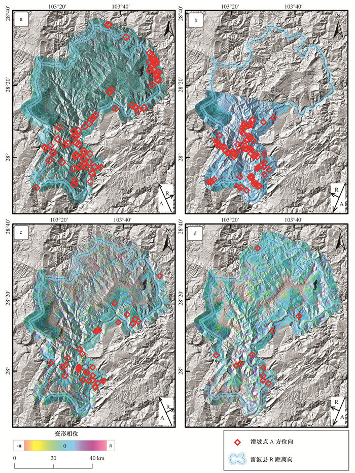
图 3 SAR数据覆盖范围及滑坡解译图
a—PALSAR-1;b—PALSAR-2;c—Sentinel-1 A/B升轨;d—Sentinel-1 A/B降轨
Figure 3. Coverage area of SAR data and interpretation map of landslides

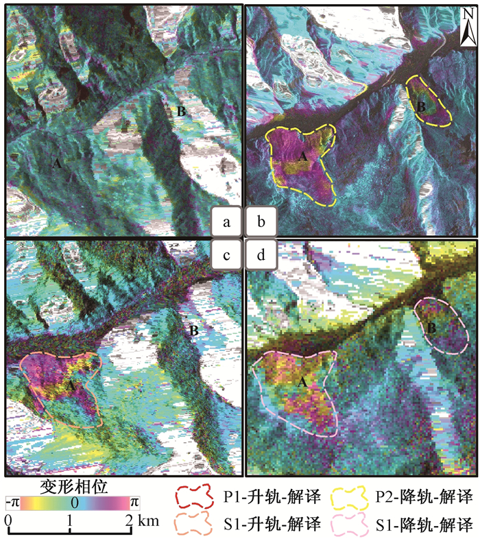
图 5 分幅影像解译图
a—PALSAR—1升轨;b—PALSAR—2降轨;c—Sentinel—1 A/B升轨;d—Sentinel—1 A/B降轨。
Figure 5. Interpretation map of iframing images

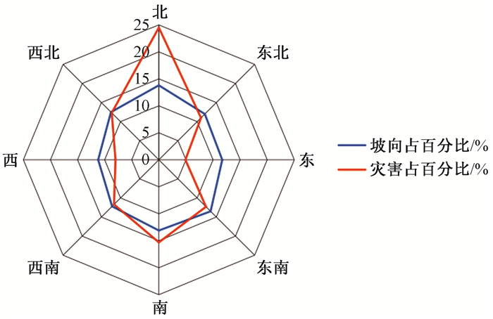
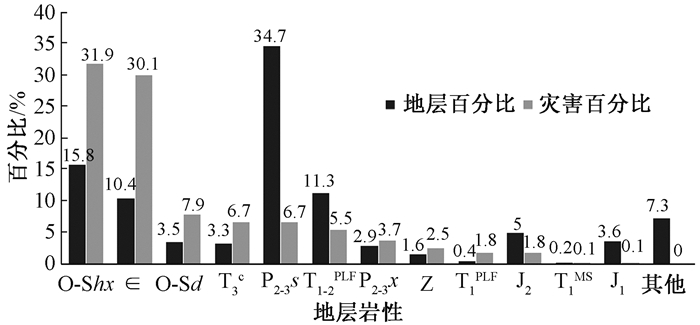
图 8 滑坡在不同地层岩性中分布的比例
O-Shx—奥陶—志留系红石崖组—回星哨组碳酸盐岩及碎屑岩;∈—寒武系筇竹寺组—娄山关组泥页岩、粉砂岩、砂岩、灰岩、白云岩(底部含磷);O-Sd—奥陶—志留系红花园组/大路寨组并层页岩、笔石页岩、灰岩夹钙质页岩、钙质砂岩、白云岩;T3C—上三叠统宝顶组/白果湾组陆相长石石英砂岩、粉砂岩、泥岩夹煤;P2-3s—中—上二叠统树河组/梁山组—宣威组/黑泥哨组下部为砂页岩、灰岩、白云岩,上部为拉斑玄武岩偶含砂页岩;T1-2PLF—下—中三叠统飞仙关组—雷口坡组台地相以灰岩、白云岩为主,底部为页岩,顶部岩溶角砾岩;P2-3x—中上二叠统梁山组/峨眉山组—宣威组并层砂岩夹页(泥)岩、煤层,灰岩及玄武岩;Z—震旦系观音崖组—灯影组白云岩,底为砂岩、页岩;T1PLF—下三叠统东川组/飞仙关组—嘉陵江组台地相,以灰岩、白云岩为主,底部页岩;J2—中侏罗统千佛岩组—沙溪庙组,灰—紫红色泥岩、粉砂岩、砂岩夹灰岩;T1MS—下三叠统飞仙关组浅海相紫红色泥(页)岩夹灰岩;J1—下侏罗统自流井组/新田沟组紫红色泥岩、砂岩、粉砂岩夹灰岩、泥灰岩
Figure 8. Percentage of landslides in different strata and lithologies

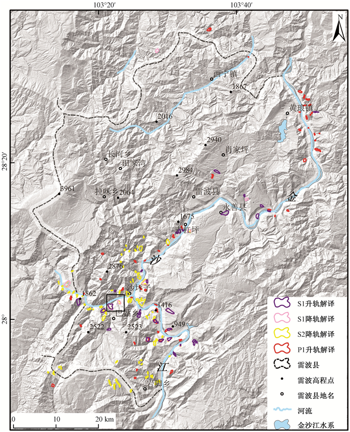
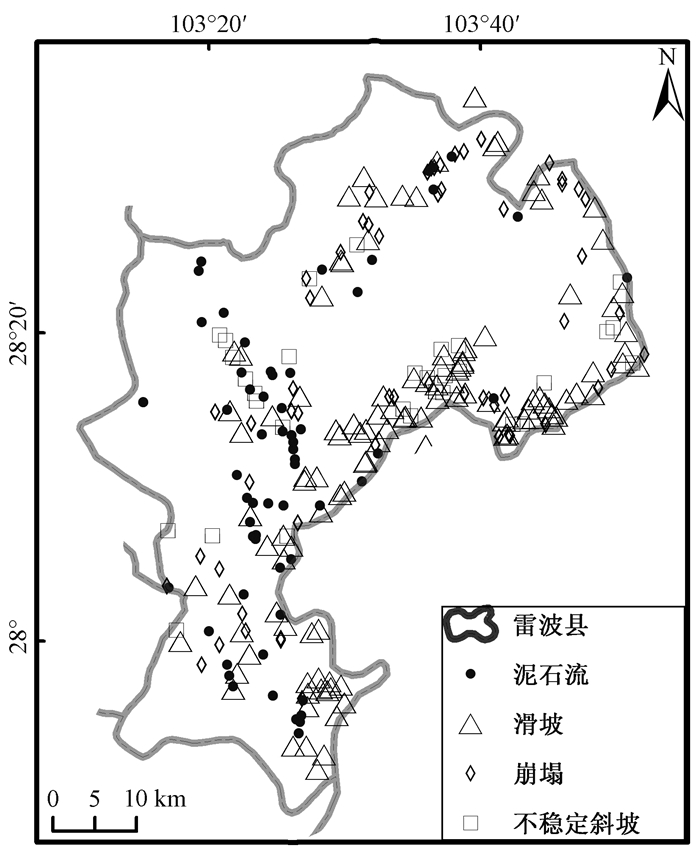
图 9 地面调查的雷波县地质灾害点
Figure 9. Geological hazard sites in Leibo County through field survey

图 10 InSAR解译滑坡点与地面调查滑坡对照
Figure 10. Comparison between landslides detected by InSAR and those surveyed in field
表 1 所选数据类型及卫星传感器基本参数
Table 1. The selected data type and main parameters of the satellite sensor
星载SAR系统 波长/cm 极化方式 观测方向 数据日期 平均基线/m 侧视角/(°) 分辨率/m 灾害个数 PALSAR-1 L(23.6) HH 升轨 2007-07-07、2007-08-22、2007-08-22、2008-01-07、2008-04-08、2008-05-24、2009-01-09、2009-02-24、2009-08-27、2010-01-12、2010-02-27、2011-01-15和2011-03-02 299 38.74 12 75 PALSAR-2 L(23.8) HH 降轨 2016-10-22和2017-01-28 56 39.66 3.0 81 Sentinel-1 A/B C(5.6) VV 升轨 2016-01-07和2017-03-08 45 33.91 15 11 Sentinel-1 A/B C(5.6) VV 降轨 2016-12-03和2017-12-27 30 33.95 15 34  下载: 导出CSV
-
[1] 许强, 汤明高, 徐开祥, 等.滑坡时空演化规律及预警预报研究[J].岩石力学与工程学, 2008, 27(6):1104~1112. https://www.wenkuxiazai.com/doc/ddbc681ff46527d3240ce0be.htmlXU Qiang, TANG Minggao, XU Kaixiang, et al. Research on space-time evolution laws and early warning-prediction of landslides[J]. Chinese Journal of Rock Mechanics and Engineering, 2008, 27(6):1104~1112. (in Chinese with English abstract) https://www.wenkuxiazai.com/doc/ddbc681ff46527d3240ce0be.html [2] Ferretti A. Satellite InSAR data:reservoir monitoring from space[M]. Houten:European Association of Geoscientists & Engineers, 2014. [3] 廖明生, 王腾.时间序列InSAR技术与应用[M].北京:科学出版社, 2014.LIAO Mingsheng, WANG Teng. Time series InSAR technology and application[M]. Beijing:Science Press, 2014. (in Chinese) [4] Fruneau B, Achache J, Delacourt C. Observation and modelling of the Saint-Étienne-de-Tinée landslide using SAR interferometry[J]. Tectonophysics, 1996, 265(3/4):181~190. https://www.sciencedirect.com/science/article/pii/S0040195196000479 [5] Rott H, Scheuchl B, Siegel A, et al. Monitoring very slow slope movements by means of SAR interferometry:a case study from a mass waste above a reservoir in the Ötztal Alps, Austria[J]. Geophysical Research Letters, 1999, 26(11):1629~1632. doi: 10.1029/1999GL900262 [6] Yin, Y., Zheng, W., Liu, Y., et al. Integration of GPS with InSAR to monitoring of the Jiaju landslide in Sichuan, China[J]. Landslides, 2010, 7:359~365. doi: 10.1007/s10346-010-0225-9 [7] Yao X, Li L J, Zhang Y S, et al. Types and characteristics of slow-moving slope geo-hazards recognized by TS-InSAR along Xianshuihe active fault in the eastern Tibet Plateau[J]. Natural Hazards, 2017, 88(3):1727~1740. doi: 10.1007/s11069-017-2943-y [8] 陈进, 徐平.金沙江科学考察的几个问题及思考[J].长江科学院院报, 2013, 30(7):1~6. http://d.old.wanfangdata.com.cn/Periodical/cjkxyyb201307001CHEN Jin, XU Ping. Considerations on the scientific investigation of Jinsha River[J]. Journal of Yangtze River Scientific Research Institute, 2013, 30(7):1~6. (in Chinese with English abstract) http://d.old.wanfangdata.com.cn/Periodical/cjkxyyb201307001 [9] 曾陈萍, 张宏平.物联网技术在山洪灾害监测预警系统中的应用研究[J].西昌学院学报·自然科学版, 2014, 28(3):56~59. http://www.wanfangdata.com.cn/details/detail.do?_type=perio&id=xcxtxb201403017ZENG Chenping, ZHANG Hongping. A review of the application of internet of things in the mountain torrent disaster monitoring and early-warning system[J]. Journal of Xichang College·Natural Science Edition, 2014, 28(3):56~59. (in Chinese with English abstract) http://www.wanfangdata.com.cn/details/detail.do?_type=perio&id=xcxtxb201403017 [10] 孙瑜, 李宏俊, 曹树波, 等.四川雷波碉楼沟泥石流特征及防治对策[J].地质灾害与环境保护, 2017, 28(1):1~6. http://edu.wanfangdata.com.cn/Periodical/Detail/zhx200904001SUN Yu, LI Hongjun, CAO Shubo, et al. Features and preventive countermeasures of potential debris flow in Diaolou Gully, Leibo county, Sichuan province[J]. Journal of Geological Hazards and Environment Preservation, 2017, 28(1):1~6. (in Chinese with English abstract) http://edu.wanfangdata.com.cn/Periodical/Detail/zhx200904001 [11] 陈炳蔚, 李永森, 符振康.金沙江构造带及邻区的构造变形特征[J].青藏高原地质文集, 1991, 21:222~234. http://cpfd.cnki.com.cn/Article/CPFDTOTAL-ZGDJ199112001019.htmCHEN Bingwei, LI Yongsen, FU Zhenkang. Deformations of Jinshajiang tectonic belt and its adjacent areas[J]. Contribution to the Geology of the Qinghai-Xizang (Tibet) Platean, 1991, 21:222~234. (in Chinese with English abstract) http://cpfd.cnki.com.cn/Article/CPFDTOTAL-ZGDJ199112001019.htm [12] 姚鑫, 许冲, 戴福初, 等.四川汶川Ms8级地震引发的滑坡与地层岩性、坡度的相关性[J].地质通报, 2009, 28(8):1156~1162. http://www.oalib.com/paper/4897679YAO Xin, XU Chong, DAI Fuchu, et al. Contribution of strata lithology and slope gradient to landslides triggered by Wenchuan Ms 8 earthquake, Sichuan, China[J]. Geological Bulletin of China, 2009, 28(8):1156~1162. (in Chinese with English abstract) http://www.oalib.com/paper/4897679 [13] Colesanti C, Wasowski J. Investigating landslides with space-borne Synthetic Aperture Radar (SAR) interferometry[J]. Engineering Geology, 2006, 88(3/4):173~199. https://www.sciencedirect.com/science/article/pii/S001379520600250X [14] Waltham T. Foundations of engineering geology[M]. 2nd ed. Boca Raton:CRC Press, 2002. -

 下载:
下载:


计量
- 文章访问数: 523
- HTML全文浏览量: 198
- PDF下载量: 43
- 被引次数: 0
