METHOD FOR THE CONSTRUCTION OF THE GEOLOGICAL MAP DATABASE BASED ON MAPGIS——EXAMPLE FROM THE 1:1 M GEOLOGICAL MAP DATABASE OF CHINA
-
摘要: 随着国家信息化的迅速发展, 新技术和新理论的不断进步, 地质图数据库的建立成为当前发展的趋势。利用GIS建立地质图数据库, 便于地质数据的存储、查询、分析和更新, 为实现了信息共享奠定了基础。本文以全国1:100万地质图数据库为例, 从编图设计、资料准备、数据处理、投影变换、数据套合及接边、数据库建立、数据检查及更新等几个方面介绍了应用MAPGIS平台建立地质图数据库的方法。Abstract: With the rapid development of informationization and continuous advances in technology and theory in China, the establishment of the geological map database has become the current trend of development.The geological map database based on GIS is convenient for the storage, inquiry, analysis and updating of the geological data, thus laying a foundation for information sharing.Take for example the 1:1 M Geological Map Database of China, this paper introduces the method of building the geological map database based on MAPGIS in such aspects as mapping design, data preparation, data processing, projection conversion, map connection, database building and data examination and updating.
-
Key words:
- geological information system /
- MAPGIS /
- geological map database /
- attribute database
-
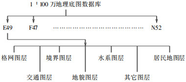
表 1 地理底图数据库图层(以J50幅为例)
Table 1. Layers of the geographic base map database (take Sheet J50 for example)

表 2 面元属性结构
Table 2. Attribute structure of the surface element

表 3 地质界线及断层的属性结构
Table 3. Attribute structure of the geological boundaries and faults

表 4 点元属性结构
Table 4. Attribute structure of the point element

附表 山丹台体应变仪同震变化基本参数
附表. Basic parameters of body strain in the same earthquake change at the Shandan station

-
[1] 翟亮, 唐新明, 周一, 等.国家基础地理信息数据库内容的完善[J].测绘通报, 2006, (1):47~48. doi: 10.3969/j.issn.0494-0911.2006.01.014 [2] 韩坤英, 丁孝忠, 范本贤, 马丽芳, 剧远景, 王振洋.MAPGIS在建立地质图数据库中的应用[J].地球学报, 2005, 26 (6):587~590. doi: 10.3321/j.issn:1006-3021.2005.06.017 [3] 祁兰英.概述地质图空间数据库的建设[J].青海国土经略, 2001, 1 :74~78. http://www.wanfangdata.com.cn/details/detail.do?_type=perio&id=QK200101219102 [4] 张庆合, 曹邦功, 姜兰.1:50万地质图数据库的研建[J].中国地质, 2002, 29 (2):208~212. doi: 10.3969/j.issn.1000-3657.2002.02.019 [5] 陈为公.应用GIS建立地质图空间数据库初探[J].辽宁地质, 2002, 17 (4):312~314. http://www.wanfangdata.com.cn/details/detail.do?_type=perio&id=QK200000843424 [6] 黄杏元, 马劲松, 汤勤.地理信息系统概论[J].北京:高等教育出版社, 2001.12. [7] 韩坤英, 丁孝忠, 李廷栋, 等.全国1:100万地质图空间数据库建设进展[J].中国地质, 2007, 34 (2):359~364. doi: 10.3969/j.issn.1000-3657.2007.02.020 [8] 李跃辉.地理信息系统(MapGis)在地质制图中的应用[J].地质力学学报, 2006, 12 (2):274~278. doi: 10.3969/j.issn.1006-6616.2006.02.022 -


 下载:
下载:


