GEOLOGICAL HAZARDS MONITORING AND APPLICATION IN MOUNTAINOUS TOWN OF THREE GORGES RESERVOIR
-
摘要: 以三峡库区羊角场镇为例,在地质调查基础上,利用伸缩位移计、应力计等常规地面监测设备,对地表裂缝相对位移和危岩体基座应力进行监测,并结合GPS静态和实时动态测量等技术,开展了角反射器干涉测量技术(CR-InSAR)和高相干InSAR技术在复杂山区地质灾害大范围调查与识别应用,从点到面、从大型危岩体到区域地表形变全覆盖。各种方法监测结果较为一致,有效实现了典型山区城镇地质灾害变形的高精度、动态立体化监测。Abstract: Regular geological hazards monitoring is very difficult in southwestern mountainous area, due to steep terrain, abundant plants, rainy and foggy weather. On the basis of geological hazards survey, a comprehensive monitoring network has been established. Regular geo-hazards monitoring devices, such as telescopic displacement meters and stressometers, are installed to monitor relative displacement of ground cracks and stress in base of perilous rock respectively. Static and real-time GPS, as well as corner reflector interferometry (CR-InSAR), are applied to monitor ground movement of perilous rocks. In order to obtain regional deformation, high coherence InSAR is adopted to investigate and detect geo-hazards. The Yangjiao monitoring network achieves high-resolution and real-time monitoring, and the methods applied are essentially in agreement with movement results.
-
Key words:
- mountainous town /
- geological hazards monitoring /
- perilous rock /
- InSAR
-
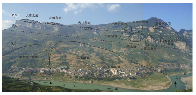
表 1 羊角场镇大型危岩体特征表
Table 1. Charateristics of large-scale perilous rock masses in Yangjiao area
危岩名称 岩性 滑坡形态 破坏模式 大巷危岩 二叠系吴家坪组灰岩 长条形 视向滑动式 庆峰危岩Ⅰ 长条形 视向滑动式 庆峰危岩Ⅱ 柱状 滑塌式 庆口危岩 长条形 视向滑动式 小湾后危岩 柱状 滑塌式 大湾后危岩 柱状 倾倒式 观音洞危岩 不规则形 落石破坏式 小湾危岩 二叠系茅口组灰岩 柱状 滑塌式 大湾危岩 柱状 滑塌式 大湾北危岩 锥状 滑塌式 观音洞北危岩 柱状 滑塌式 表 2 羊角场镇的地质灾害遥感监测结果(单位:mm)
Table 2. Monitoring results of geohazards via remote sensing methods in Yangjiao area
点号 测量方法 东 北 水平位移量 垂直* 点位 位移方向 监测时间 JT01 静态GPS -7.0 0.0 7.0 24.0 大巷危岩 南 2014/10—2015/10 JT02 -2.0 -2.0 2.8 10.0 西南 JT03 -1.0 3.0 3.2 -1.0 东南 JT04 静态GPS -1.0 -3.0 3.2 -16.0 庆峰危岩 西南 2012/11—2015/10 CR01 角反射器干涉 - - 11.0 -4.0 西南 2012/06—2014/01 JT05 静态GPS -8.0 -1.0 8.1 -16.0 西南 2012/11—2015/10 CR02 角反射器干涉 - - 21.0 -8.0 西南 2012/06—2014/01 DT01 静态GPS 5.0 -11.0 12.1 -5.0 西北 2013/10—2015/09 动态GPS 4.5 -6.4 7.8 -12.2 西北 JT06 静态GPS 5.0 -5.0 7.1 -29.0 西北 2013/10—2015/10 DT02 静态GPS -3.0 4.0 5.0 -36.0 庆口危岩 东南 2013/10—2015/07 动态GPS -1.4 5.2 5.4 4.6 东南 JT07 静态GPS -3.0 1.0 3.2 -59.0 羊角滑坡 东南 2013/10—2015/10 JT08 0.0 1.0 1.0 -56.0 东 JT09 0.0 -9.0 9.0 -51.0 西 *:位移方向垂直向下为负,向上为正 -
[1] 殷跃平.三峡工程库区移民迁建区地质灾害与防治[J].地质通报, 2002, 2(12):876~880. doi: 10.3969/j.issn.1671-2552.2002.12.011YIN Yue-ping. Geohazards and their prevention in resettlement areas of emigrants from the reservoir region of the Three Gorges Project[J]. Geological Bulletin of China, 2002, 21(12):876~880. doi: 10.3969/j.issn.1671-2552.2002.12.011 [2] 殷跃平. 加强城镇化进程中的地灾防治工作[N]. 中国国土资源报, 2014-04-21(4).YIN Yue-ping. Enhance geological hazards mitigation in urbanization process[N]. China Land and Resource News, 2014-04-21(04). [3] 刘传正.重庆武隆羊角镇工程地质环境初步研究[J].水文地质工程地质学报, 2013, 40(2):1~8. http://www.cnki.com.cn/Article/CJFDTOTAL-SWDG201302003.htmLIU Chuang-zhen. Primary research on the geological environment around Yangjiao Twon in Wulong County, Chongqing, China[J]. Hydrogeology and Engineering Geology, 2013, 40(2):1~8. http://www.cnki.com.cn/Article/CJFDTOTAL-SWDG201302003.htm [4] 黄润秋.中国西部地区典型岩质滑坡机理研究[J].地球科学进展, 2004, 19(3):443~450. http://www.cnki.com.cn/Article/CJFDTOTAL-DXJZ200403015.htmHUANG Run-qiu. Mechanism of large scale landslides in western China[J]. Advance in Earth Sciences, 2004, 19(3):443~450. http://www.cnki.com.cn/Article/CJFDTOTAL-DXJZ200403015.htm [5] 殷跃平, 朱继良, 杨胜元.贵州关岭大寨高速远程滑坡-碎屑流研究[J].工程地质学报, 2010, 18(4):445~454. http://www.cnki.com.cn/Article/CJFDTOTAL-GCDZ201004003.htmYIN Yue-ping, ZHU Ji-liang, YANG Sheng-yuan. Investigation of a high speed and long run-out rockslide-debris floe at Dazhai in Guizhou Province[J]. Journal of Engineering Geology, 2010, 18(4):445~454. http://www.cnki.com.cn/Article/CJFDTOTAL-GCDZ201004003.htm [6] 殷跃平, 刘传正, 陈红旗, 等.2013年1月11日云南镇雄赵家沟特大滑坡灾害研究[J].工程地质学报, 2013, 21(1):6~15. http://www.cnki.com.cn/Article/CJFDTOTAL-GCDZ201301003.htmYIN Yue-ping, LIU Chuan-zheng, CHEN Hong-qi, et al, Investigation on catastrophic landslide of January 11, 2013 at Zhaojiagou, Zhenxiong County, Yunnan Province[J]. Journal of Engineering Geology, 2013, 21(1):6~15. http://www.cnki.com.cn/Article/CJFDTOTAL-GCDZ201301003.htm [7] 刘传正, 杨冰.三峡库区地质灾害调查评价与监测预警新思维[J].工程地质学报, 2001, 9(2):121~126. http://www.cnki.com.cn/Article/CJFDTOTAL-GCDZ200102002.htmLIU Chuang-zhen, YANG Bing. 2001. A new method of surveying, evaluating, monitoring and forecasting for the geological hazards in the Three Gorges on Changjiang River[J]. Journal of Engineering Geology, 2001, 9(2):121~126. http://www.cnki.com.cn/Article/CJFDTOTAL-GCDZ200102002.htm [8] 王磊, 李滨, 冯振, 等.武隆县羊角场镇厚层灰岩山体大型危岩体破坏模式及成因机制研究[J].地质学报, 2015, 89(2):461~471. http://www.cnki.com.cn/Article/CJFDTOTAL-DZXE201502019.htmWANG Lei, LI Bin, FENG Zhen, et al. The failure patterns and their formation mechanisms of large perilous rocks in thick layered limestone masses in Yangjiao Town, Wulong[J]. Acata Geologica Sinica, 2015, 89(2):461~471. http://www.cnki.com.cn/Article/CJFDTOTAL-DZXE201502019.htm [9] 张勤.GPS监测滑坡形变的基准研究[J].西安工程学院学报, 2001, 23(4):69~71. http://www.cnki.com.cn/Article/CJFDTOTAL-XAGX200104014.htmZHANG Qin. The datum research of the slope deformation monitor by GPS[J]. Journal of Xi'an Engineering University, 2001, 23(4):69~71. http://www.cnki.com.cn/Article/CJFDTOTAL-XAGX200104014.htm [10] 朱建军, 邢学敏, 胡俊, 等.利用InSAR技术监测矿区地表形变[J].中国有色金属学报, 2011, 21(10):2564~2576. http://www.cnki.com.cn/Article/CJFDTOTAL-ZYXZ201110024.htmZHU Jian-jun, XING Xue-ming, HU Jun, et al. Monitoring of ground surface deformation in mining area with InSAR technique[J]. Chinese Journal of Nonferrous Metals, 2011, 21(10):2564~2576. http://www.cnki.com.cn/Article/CJFDTOTAL-ZYXZ201110024.htm [11] 邢学敏, 朱建军, 汪长城, 等.一种新的CR点目标识别方法及其在公路形变监测中的应用[J].武汉大学学报:信息科学版, 2011, 36(6):699~703. http://www.cnki.com.cn/Article/CJFDTOTAL-WHCH201106017.htmXING Xue-ming, ZHU Jian-jun, WANG Chang-cheng, et al. A new method for CR point identification and it's application to highway deformation monitoring[J]. Geomatics and Information Science of Wuhan University, 2011, 36(6):699~703. http://www.cnki.com.cn/Article/CJFDTOTAL-WHCH201106017.htm [12] 许文斌, 李志伟, 丁晓利, 等.利用InSAR短基线技术估计洛杉矶地区的地表时序形变和含水参数[J].地球物理学报, 2012, 55(2):452~461. http://www.cnki.com.cn/Article/CJFDTOTAL-DQWX201202008.htmXU Wen-bin, LI Zhi-wei, DING Xiao-li, et al. Application of small baseline subsets D-InSAR technology to estimate the time series land deformation and aquifer storage coefficients of Los Angeles area[J]. Chinese Journal Geophysics, 2012, 55(2):452~461. http://www.cnki.com.cn/Article/CJFDTOTAL-DQWX201202008.htm -


 下载:
下载:


